1. Introduction
Underwater cultural heritage includes all submerged cultural, historical, and archaeological elements, such as artefacts, shipwrecks, and sites, preserved in their natural aquatic contexts. UNESCO’s 2001 Convention [
1] highlights the importance of safeguarding this heritage, promoting in situ preservation, and raising awareness about its vulnerabilities, including those caused by climate change, biodiversity shifts, and human activities. Research on underwater heritage contributes to historical understanding, conservation science, and climate impact studies while emphasising ethical exploration and advanced technologies for sustainable management. Balancing protection with accessibility, experts advocate for controlled regulation to ensure preservation and harmonious integration with cultural promotion efforts. Effective policies and mapping strategies are vital for protecting this fragile heritage against environmental and human threats while advancing global efforts in heritage conservation.
Porto, a UNESCO World Heritage Site since 1996, is located at the mouth of the Douro River on the Atlantic coast of Portugal. Throughout history, the Douro estuary has been characterised by hazardous navigation conditions, frequent floods, intense commercial activity, and the presence of port infrastructures and defensive structures. Historical documentation records numerous shipwrecks, military episodes, and riverbank transformations, suggesting a strong potential for submerged archaeological remains distributed along both the riverbed and adjacent waterfront sectors.
In this context and focusing on mapping strategies essential for preserving underwater heritage while simultaneously advancing research to enhance the understanding of Porto’s history, this study presents a methodological approach based on the analysis of historical maps to identify potential underwater heritage sites along the riverbanks and riverbed. The resulting map is intended to guide an initial side-scan sonar survey and other non-invasive investigations aimed at identifying and mapping submerged structures and priority areas for future verification. These preliminary results may also support the future development of predictive models for assessing the distribution and extent of underwater heritage. The present study should be understood as a preliminary analytical step aimed at identifying areas of archaeological potential based on historical cartography. By providing a cost-effective spatial screening framework, this approach supports the prioritisation of future investigations, which may incorporate additional survey techniques. The significance of this study lies in demonstrating that historical cartography can be operationalised as a predictive screening tool for underwater cultural heritage through the integration of historical maps, documentary evidence, and GIS in a fluvial–estuarine urban context where systematic underwater inventories remain limited.
Historical maps provide valuable insights into the geographical, cultural, and political landscapes of the past, revealing information about natural resources, settlement evolution, heritage development, and long-term land use. They capture socio-economic and administrative realities, aiding in historical analysis and strategic planning. Researchers use these maps to reconstruct ancient coastlines, analyse maritime resource usage, and uncover navigation routes, shedding light on landscape evolution, human–environment interactions, and trade patterns. Beyond artefacts and shipwrecks, historical maps enhance understanding of past relationships between humans and aquatic environments, documenting changes in coastal physiognomy, port defences, infrastructure, and resource usage. These tools are essential for studying underwater heritage and the dynamics of historical riverbanks and maritime environments.
Historical maps, sourced from Porto’s Municipal Historical Archive (GISA—Gestão Integrada de Sistemas de Arquivo) and the National Library of Portugal’s Digital Collection (BNDigital), provide valuable insights into Porto’s geography, river navigation challenges, and maritime activities. Combined with historical documents, these resources highlight the archaeological and historical significance of Porto’s riverbed and its contribution to understanding the region’s past.
In view of the strong likelihood of uncovering remains within the riverbed and along its banks, as documented in historical sources and prior studies, a map was created to mark locations with a high probability of containing underwater archaeological heritage. This map was developed based on both cartographic records and written historical documents.
2. Literature Review
2.1. Protection and Safeguarding of Underwater Heritage
The 2001 UNESCO Convention [
1] established a formal international framework for the protection of underwater cultural heritage, defining its scope and setting principles for in situ preservation, international cooperation, and responsible research practices. This includes sites, structures, artefacts, ships and their cargo, and other remnants of human activity. Heritage designation extends not only to the objects themselves but also to their archaeological and natural contexts, such as the seabed, ocean floors, aquatic environments, and their subsoil. To be recognised as heritage, these objects must have been submerged for at least 100 years, thereby excluding contemporary maritime structures and uses. It is crucial to note that the concept of “underwater cultural heritage” is distinct from terms such as “nautical heritage,” “maritime heritage,” or “coastal heritage.” These latter terms encompass all ships, structures, artefacts, and both tangible and intangible heritage related to the aquatic environment, which are located on the surface [
2].
Since the 2001 Convention for the Protection of Underwater Cultural Heritage [
1], submerged cultural heritage in aquatic environments has attracted increasing attention among archaeologists and heritage professionals. Extensive efforts have been dedicated to the safeguarding, study, and dissemination of these elements, which are crucial for understanding history and world heritage. In 2017, the Tunis Declaration [
3] highlighted the need to protect heritage, including underwater heritage in the Mediterranean, urging Mediterranean countries to prioritise this effort. Consequently, international guidelines emphasise the importance of fostering research and coordinated action in this often-overlooked field. Attention to submerged heritage has further increased following the proclamation of the UNESCO Decade of Ocean Science for Sustainable Development 2021–2030, which reinforces the need to protect and better understand underwater cultural assets within broader ocean sustainability agendas.
Archaeologists and historians agree that studying and uncovering the information contained in these cultural assets can deepen understanding of past human activity, environmental change, and the long-term interaction between societies and aquatic environments [
4]. Aquatic environments—including oceans, seas, lakes, and rivers—remain largely unexplored, presenting opportunities for rigorous and ethical exploration [
2]. Research in this field continues to facilitate the construction and reconstruction of historical analyses across various domains, including military, economic, political, and social history, as well as the history of science and technology. It also contributes to the study of material preservation and conservation processes in aquatic environments, advancing scientific knowledge on material preservation. Simultaneously, research in underwater heritage will provide insights into the natural processes, climatic variability, geological events, coastal dynamics, and many other natural processes of our planet. It will also help us understand the effects of climate change and current human activities on the future of water. In this context, Pérez-Reverte Mañas et al. [
4] argue that archaeologists, historians, and heritage professionals must take a more active role in the study, conservation, protection, and enhancement of underwater heritage resources, which significantly impact the economies of countries. Perez-Alvaro [
2] emphasises that research in this area is fundamental for increasing the understanding of past human behaviours and for enhancing the appreciation and interpretation of heritage.
Having defined the concept of underwater cultural heritage and clarified its importance, the protection, preservation, and management of such heritage are framed within the principles of the UNESCO Convention [
1], particularly as established in Article 2 and Annex Rule 1. In situ preservation is recognised as the first option, referring to the study and conservation of heritage at its original location while maintaining the integrity of its archaeological context. In situ preservation must be assessed considering the rapid deterioration that may affect submerged cultural remains [
5].
However, preserving underwater cultural heritage in situ may encourage the development of controlled diving routes or archaeological parks, potentially affecting local biodiversity and underwater environments if not carefully managed. At the same time, public recognition and identification of submerged heritage are essential steps in ensuring its protection. Increased visibility can generate both opportunities for conservation and risks associated with greater access and tourism pressure. Therefore, the challenge lies not in limiting knowledge or appreciation, but in framing appropriate management strategies that balance accessibility, protection, and environmental sustainability [
6,
7,
8].
Specialists outline other significant concerns arising from climate change and its impacts on underwater heritage and its resilience [
2,
9,
10]. They refer to the rising water temperatures that promote chemical changes, alterations in maritime currents, and changes in protective sediments that can have destructive consequences. These include shifts in salinity and water acidification, as well as chemical changes that will affect materials. The rise in sea levels, coupled with an increase in storms and coastal flooding, is also highlighted. Additionally, alterations in sea levels and coastal wave patterns pose a significant challenge for preserving and conserving underwater cultural heritage [
10]. Despite all the recommendations from experts and the findings of scientific studies, the risks arising from the lack of a concrete policy for underwater heritage remain a reality.
Estuarine environments are particularly sensitive to climate-related pressures, including sea-level rise, altered sediment dynamics, and the intensification of extreme hydrological events. According to the IPCC Sixth Assessment Report [
11,
12], global changes in temperature and sea level are altering coastal and transitional systems, with implications for erosion and sediment redistribution in estuaries and river mouths [
11,
12]. Empirical analyses further indicate that sea-level rise and associated physical changes can directly influence the preservation, exposure, and morphological configuration of submerged cultural heritage in these dynamic settings [
13]. These processes reinforce the need for anticipatory spatial identification frameworks in historically active fluvial–estuarine contexts.
A balance must be maintained between the ecological stability of underwater environments and the study, conservation, and public appreciation of culturally significant remains. In this regard, Garcia and Barreiros [
14] advocate for attentive monitoring and assessment of environmental degradation impacts as a methodology to maintain balance. Bruno et al. [
15] reinforce that, in this context, the exploration of new technologies is fundamental to ensuring knowledge and accessibility, thereby avoiding the use of less sustainable work methodologies. Despite these risks, Nunes and Roeder [
16] argue that underwater cultural heritage can be effectively integrated into coastal tourism destinations traditionally associated with sun-and-sand tourism, provided that appropriate regulatory and management frameworks are in place. Effective and carefully regulated management is also essential to ensure the conservation and enhancement of these fragile assets. Given their vulnerability to specific environmental conditions, these cultural assets are highly fragile. Therefore, policymakers, in collaboration with experts, should develop management plans that ensure the sustainable conservation and protection of submerged materials [
17].
Effective protection requires the identification of site locations, the characterisation of their environmental context, and the assessment of the risks to which they are exposed. This comprehensive approach facilitates the implementation of specialised strategies aimed at preserving and protecting invaluable heritage elements and sites. By thoroughly mapping and studying these underwater locations, potential dangers can be anticipated and addressed, thereby strengthening the overall efforts for their protection and conservation.
2.2. Using Historical Maps for Underwater Heritage Detection and Mapping
The use of historical maps offers invaluable insights into the geographical, cultural, and political landscapes of the past. They serve as essential tools for understanding the distribution of natural resources, the evolution of settlements, and the development of heritage over time, as well as long-term land use and land cover [
18]. They often preserve spatial information that is absent from other historical sources about the land, settlements, and infrastructure that existed in the past. These maps not only illustrate the physical landscapes of regions but also capture the socio-economic and administrative realities of their time. They provide valuable insights into each epoch, supporting historical analysis, spatial interpretation, and land use reconstruction [
19]. From the same perspective, Manfio and Arnim [
20] highlight that historical maps enable researchers to reconstruct ancient coastlines, analyse maritime resource usage, and uncover historical navigation routes, offering valuable insights into landscape evolution, human–environment interactions, and patterns of trade and exploration.
Building upon this, the integration of Geographic Information Systems (GIS) into historical research has significantly transformed the methodologies employed by historians and geographers [
21,
22,
23]. Historical GIS facilitates the spatial analysis of historical data, enabling scholars to visualise and interpret temporal changes in landscapes, demographics, and socio-political structures. The digitisation and georeferencing of historical maps allow for the reconstruction of past geographies, offering insights into urban development, land use patterns, and environmental change over time [
24,
25,
26]. The use of GIS in the historical investigation of urban waterfronts has proven particularly valuable in understanding past settlement morphologies and coastal transformations—key elements in the study of submerged heritage. This is especially relevant where historical shorelines and infrastructure (e.g., quays, docks, fortifications) overlap with present-day aquatic environments. For example, Aouissi et al. [
27] examined the morphological evolution of the port-city interface in Algiers from the 16th century to the present, employing a geo-historical approach to trace the origins of the enduring division between the port and the city.
Moreover, GIS is now an established tool in archaeological research, supporting the identification of buried or otherwise obscured structures through the integration of remote sensing techniques and aerial imagery analysis, increasingly enhanced by artificial intelligence algorithms embedded in GIS and remote sensing workflows, e.g., Refs. [
27,
28]. In the context of underwater cultural heritage, GIS is widely employed to develop predictive models for locating shipwrecks and other submerged sites, relying on machine learning approaches trained on previously documented cases [
29,
30,
31,
32,
33]. Consequently, the systematic identification and documentation of documented cases are essential to providing robust training datasets for these predictive models.
Beyond the traditional focus on individual shipwrecks and artefacts, a broader understanding of past human interaction with riverine and marine environments is required [
34]. Historical maps support a broader spatio-temporal understanding of these environments and their historical transformation. In this study, they are further examined as analytical sources for interpreting how communities interacted with marine and river environments, tracing changes in settlement structures and coastal or fluvial infrastructures as part of broader heritage landscape dynamics over time. In this context, the present study differs from data-intensive predictive modelling by using historical cartography and documentary evidence as the primary basis for identifying priority survey areas in an urban estuarine environment with limited georeferenced underwater data. As Contreras Rodrigo and Fernández Sánchez [
35] argued, although historical maps do not permit the observation of data related to underwater heritage, they allow for the documentation of changes in coastal physiognomy, naval engagements, port defences, wells, water sources, salt production, and toponymy, and facilitate the reconstruction of former coastlines, river uses, and historical waterfronts. These themes are particularly relevant to the archaeological study of underwater heritage.
3. Case Study and Methodology
Porto, designated a UNESCO World Heritage Site in 1996, is situated along the Atlantic coast at the mouth of the Douro River. The area offers significant potential for underwater heritage research. Archaeological discoveries in the river [
36] provide compelling evidence of its historical significance beneath the water’s surface. Similarly, historical accounts, such as those by Padre Agostinho Rebelo da Costa [
37], highlight the frequent floods and river storms in the region. These descriptions further suggest that the river may contain archaeological remains associated with Porto’s long-term occupation, particularly from the Roman period to the present day. Porto has historically been a bustling commercial hub, maintaining active maritime trade with Northern Europe and Mediterranean ports [
38].
Historical maps, as vital documents for understanding the historical landscape and identifying significant elements within Porto’s cityscape, reveal key locations that may be associated with submerged heritage now preserved in the riverbed. The maps and figures utilised during the methodological process were carefully selected to ensure accuracy and relevance to the study’s objectives. The cartography was sourced from GISA (Gestão Integrada de Sistemas de Arquivo), the archival management system of the Arquivo Histórico Municipal do Porto (Porto’s Municipal Historical Archive), and from the National Library of Portugal (BNDigital), both of which provide access to comprehensive collections of historical documents, maps, and administrative records related to the city’s historical development.
The selected maps were accessed in digital format directly through these institutional archives, and no additional digitisation process was undertaken by the authors. Consequently, potential geometric distortions related to image acquisition are attributable to the original archival digitisation procedures rather than to this study.
Although additional maps are available in GISA, they were excluded because they provide overlapping or redundant information. The selection of the five historical maps followed three complementary criteria. First, temporal representativeness was ensured to cover distinct phases of urban and fluvial transformation between the eighteenth and nineteenth centuries. Second, spatial coverage was considered, prioritising maps that comprehensively represented the Douro riverbanks and estuarine configuration within the study area. Third, thematic relevance and cartographic detail were assessed, favouring maps that clearly depicted land–water interactions, port infrastructures, defensive structures, and navigation hazards aligned with the objectives of this research.
To assess areas of potential underwater cultural heritage in the Douro River, we adopted a methodology combining historical cartography and Geographic Information Systems (GIS). This approach focuses on identifying sites of potential archaeological significance through the integration of historical documentation and spatial data.
Georeferencing was performed in QGIS version 3.44.5, open-source GIS software, using the GDAL Georeferencer plugin. This tool facilitates the process by supporting various transformation types and enabling, for each control point, the direct visualisation of residual differences as well as the calculation of Root Mean Square (RMS) error to assess alignment precision. Cascón-Katchadourian and Alberich-Pascual [
39] found QGIS to achieve the highest performance in georeferencing historical cartography, thereby confirming its suitability for aligning Porto’s historic urban maps in this study.
Between 8 and 18 control points were used per map, depending on the scale, map accuracy, and the availability of stable reference features. The resulting Root Mean Square (RMS) error values ranged between 1.52 m and 6.63 m, with an average RMS of 4.94 m. These values were considered acceptable given the historical nature of the cartographic sources and their varying geometric precision.
Control point validation was conducted through an iterative adjustment process. Points exhibiting comparatively high residual errors were reviewed and, where necessary, repositioned or excluded to improve overall alignment consistency. Preference was given to stable and persistent urban features, such as major street intersections, religious landmarks, and fortification structures, to minimise positional uncertainty. The final configuration of control points was accepted once the residual error distribution was spatially coherent and the RMS values were stabilised.
Historical map images (PDFs converted to JPEG format) were pre-processed to remove margins and enhance visibility. Control points were manually selected using identifiable, historically stable features—such as churches, fortifications, and public buildings—visible in both the historical maps and modern orthophotos produced by the Direção-Geral do Território [
40]. The orthophoto basemap was retrieved via a Web Map Service (WMS), using the official coordinate reference system for mainland Portugal PT-TM06/ETRS89 to ensure alignment with contemporary spatial data.
To validate the identification of control points, historical iconography, chronicles, and urban planning records were consulted. These sources were crucial for verifying the spatial accuracy and the existence of specific buildings or infrastructures at the time the maps were created.
Extensive literature addresses automatic georeferencing processes for historical imagery [
41,
42,
43,
44]. However, these studies focus on large-scale maps aimed at identifying natural features (waterways, water bodies, relief) or large road networks, as well as generic settlements with low levels of detail. For the urban-scale maps examined in this study, a high level of detail was required to identify elements influencing the location of potential underwater heritage sites in the Douro River. At this level of urban detail, such accuracy still requires manual georeferencing, as adopted in this study. Recent literature suggests that automated segmentation of detailed historical maps may soon become accurate using machine learning, deep learning, and artificial intelligence [
45,
46,
47].
Following the georeferencing of the historical maps, point features were created in the GIS environment for each relevant historical element identified in the selected maps. In total, 138 point features were digitised, representing navigation hazards, port infrastructures, military structures, and documented shipwreck-related locations. Features that indicated intense land–water interaction were entered into a GIS point layer, with an associated attribute table containing ‘Type’ and ‘Subtype’ fields for feature classification. An additional field recording the feature name was also included, using the information derived from the historical maps. These points were subsequently validated against the 1871 and 1892 maps to achieve precise and reliable positioning. A small number of additional points were obtained from the shipwreck database of the Portuguese Hydrographic Institute and from historical documents and secondary literature.
Overall, this methodological approach strikes a balance between historical interpretability and technical accuracy, thereby enhancing the reliability of geospatial analyses derived from historical maps in urban and coastal contexts.
4. Results
The interpretative map synthesises evidence derived from historical maps, documentary sources, and previous archaeological and environmental research on the Douro River in Porto.
Alongside the cartographic analysis, historical documents and archaeological studies were examined to provide a more comprehensive understanding of specific areas and their roles along the riverbanks. It is well established that Porto was a significant Roman settlement, which probably played a key role in advancing navigation along the Douro River to the interior of the Douro Region. This is supported by archaeological findings both at the river’s mouth and in upriver villages [
48].
During the Middle Ages, Porto remained a vital port in northern Portugal, despite the challenges posed by its difficult river entrance. Interestingly, Porto merchants viewed the frequent rise in product prices as a natural consequence of the constant loss of boats and goods at the harbour’s entrance [
49]. Agostinho Rebelo da Costa’s 1791 work [
37] provides valuable additional information on Porto’s historical topography. His description of Porto’s riverbanks highlights the dangers and the major shipwrecks that discouraged commercial traffic.
Finally, the study by Jesus [
50] documented 109 historical references to boats of various sizes and functions that were lost or involved in accidents on the Douro River between 1727 and 1980. These documentary references are not precisely located or georeferenced. Consequently, and given that they may represent only a fraction of the actual number of occurrences, identifying areas with potential underwater heritage is essential for appropriate documentation and preservation.
From the cartographic materials consulted, five historical maps were selected based on their relevance, representation of the Douro River waterfront, and cartographic reliability. These maps were obtained from the Arquivo Histórico Municipal do Porto (via GISA) and the National Library of Portugal (BNDigital), with their respective archival references indicated below.
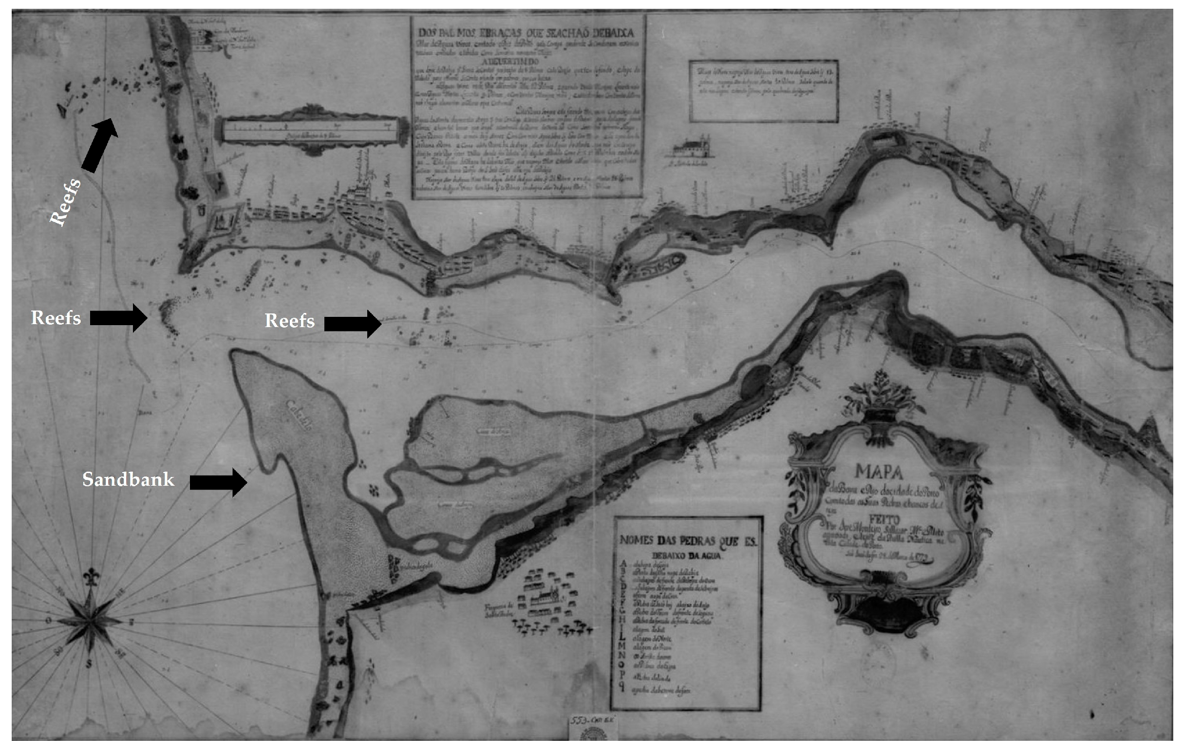
Douro River mouth in the city of Porto (1779) (
Figure 1).
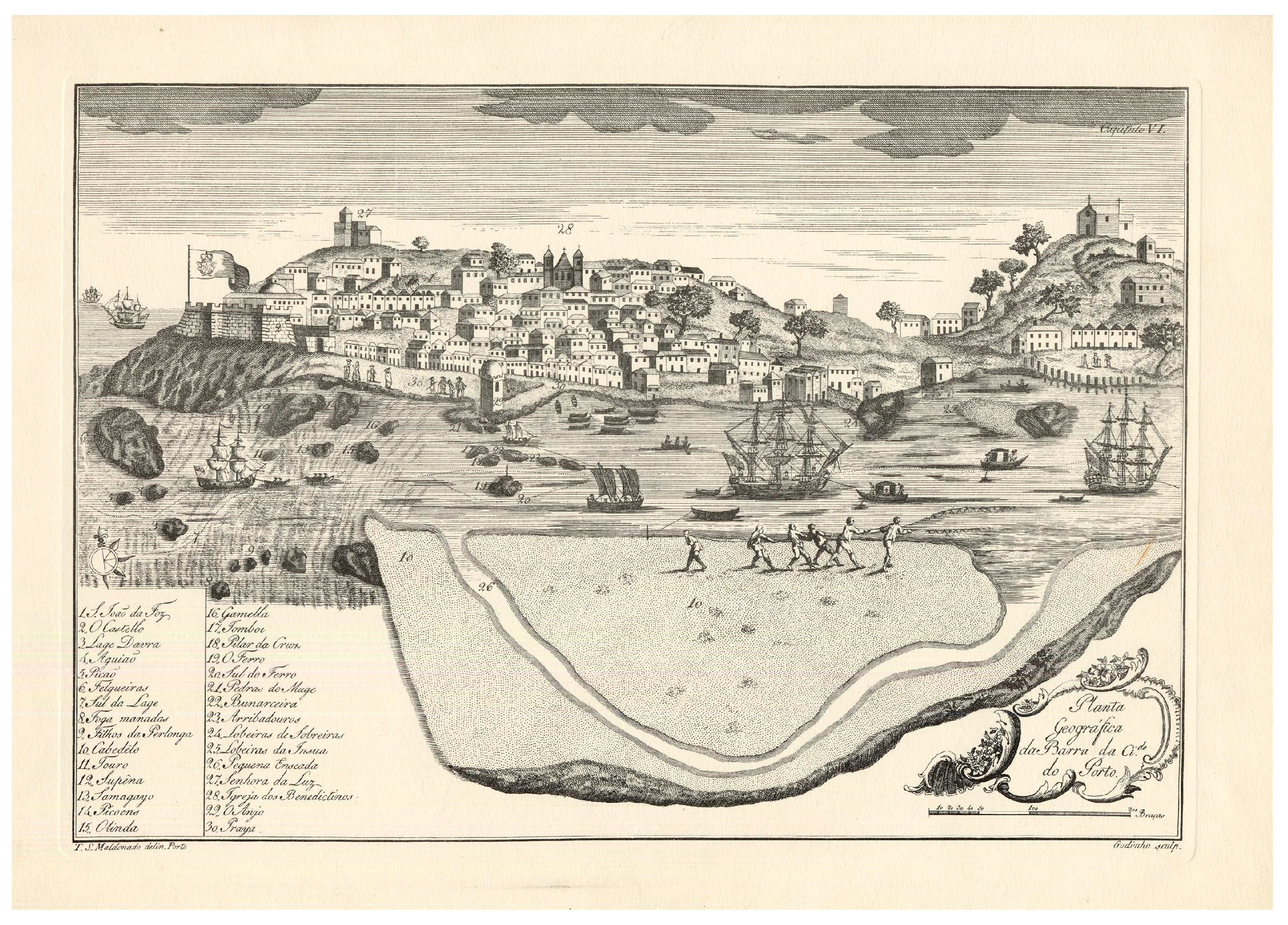
Geographical Plan of the Bar of the City of Porto, by Teodoro de Sousa Maldonado (1789) (
Figure 2).
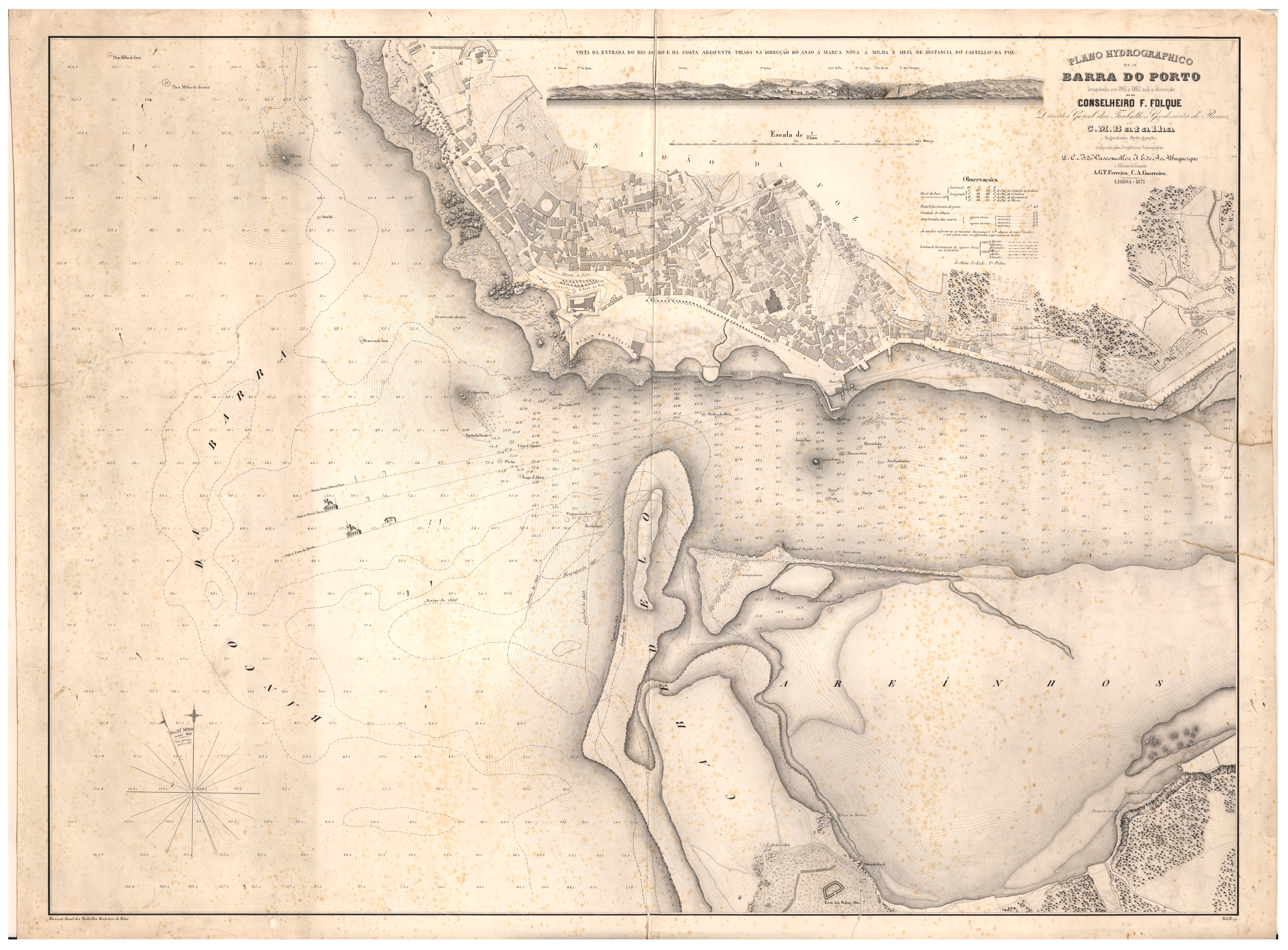
Hydrographic survey of the mouth of the Douro River, carried out between 1861 and 1862 and published in 1871 (
Figure 3). This detailed survey highlights natural features that made the area particularly hazardous for navigation and contributed to frequent shipwrecks. The map was compared with the 1779 map (
Figure 1) to assess historical changes in river morphology.
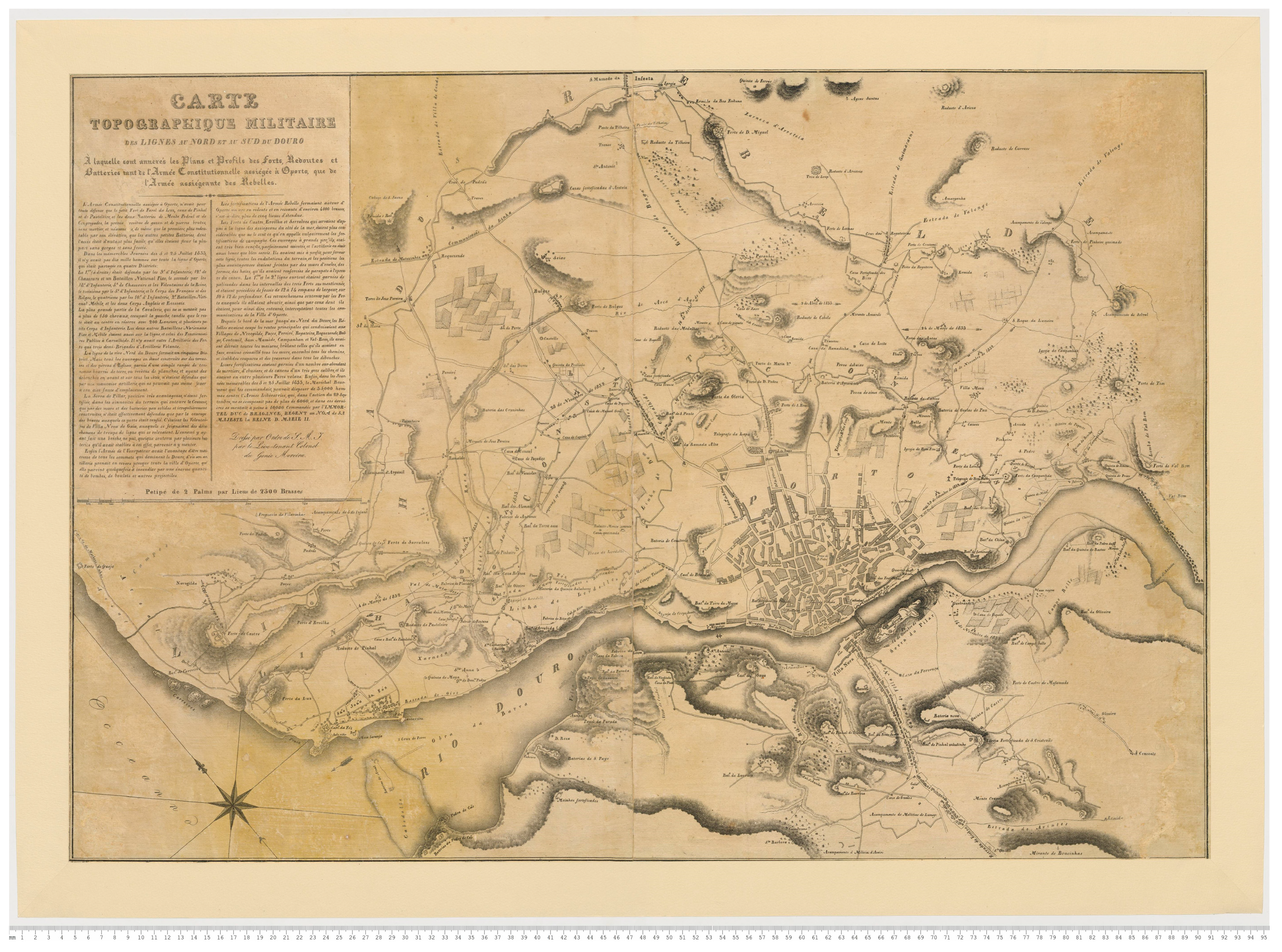
Topographic map of military fortifications (1834) (
Figure 4). This military document, produced for strategic planning purposes, presents limited geometric precision but is highly relevant for identifying defensive structures and land–water interaction points.
Topographic survey of Porto (1892) (
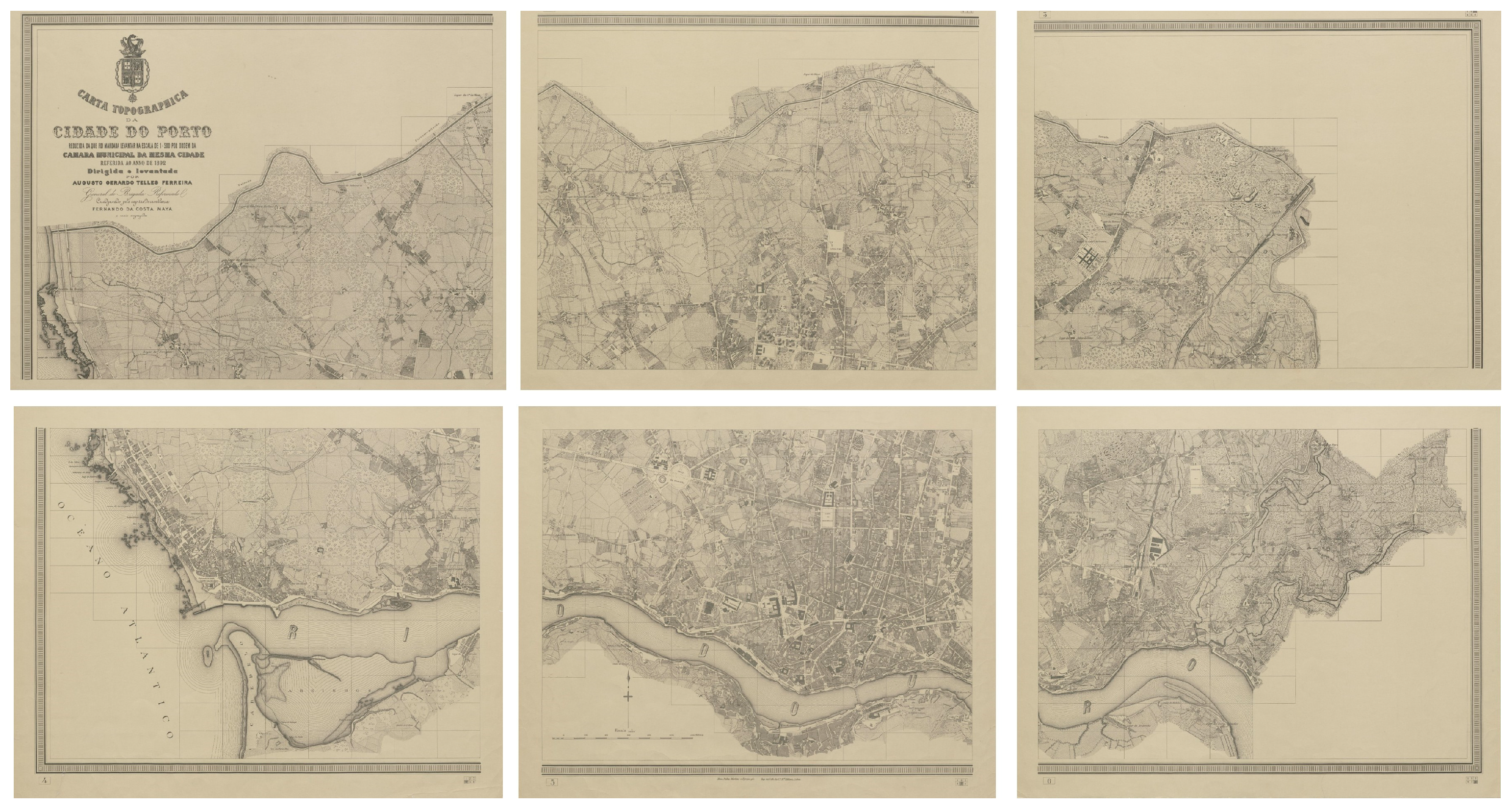
Figure 5), produced under the supervision of the military engineer Telles Ferreira. Considered the first rigorous survey of the city, it comprises 464 sheets at a 1:500 scale, later generalised into six sheets at a 1:5000 scale. For georeferencing purposes and considering the scope of this research, four sheets from the latter set were selected, covering the river and coastal fronts.
Among these, the 1892 survey (
Figure 5) was used as the primary reference layer for georeferencing due to its higher geometric precision and systematic coverage. The earlier maps (1779, 1789, and 1861–1862/1871) were primarily used for historical comparison and feature identification, while the 1834 military map supported the identification of defensive structures and strategic land–water interfaces.
Figure 1 illustrates the configuration of the Douro River mouth in 1779, highlighting reefs and sandbanks that historically posed significant navigation hazards. The map, dating back to the 18th century, provides a geographical representation of the Douro River and its banks. Additionally, it identifies settlement locations and outlines the area’s primary features, such as commercial zones, shipbuilding sites, and fishing ports.
Figure 1.
Douro River mouth in the city of Porto [
51].
Figure 1.
Douro River mouth in the city of Porto [
51].
This cartographic description is further enhanced by Teodoro de Sousa Maldonado’s 1789 Geographical Plan of the Bar of the City of Porto (
Figure 2). The engraving portrays the difficult navigation conditions at Porto’s river mouth, highlighting the potential risks and probability of accidents. In
Figure 2, the rocks positioned in the middle of the river are labelled with their commonly known names, serving to facilitate navigation and improve comprehension of the river routes for ships.
Figure 2.
Planta geográfica da barra da cidade do Porto [Geographical Plan of the Bar of the City of Porto] [
52].
Figure 2.
Planta geográfica da barra da cidade do Porto [Geographical Plan of the Bar of the City of Porto] [
52].
The same area is shown in
Figure 3, produced using more rigorous cartographic techniques by a team led by the military officer Filipe Folque, head of the Portuguese Kingdom’s Geodetic and Cartographic Services. Technically, this map was the precursor to the survey carried out in the following decades by Telles Ferreira (
Figure 5), which is considered the first geometrically and geographically accurate cartographic representation covering the entire municipality of Porto [
53]. The numerous maps produced for the mouth of the Douro River provide clear evidence of the longstanding concern regarding the navigation difficulties posed by this area.
Figure 3.
Plano hydrographico da barra do Porto [Hydrographic Plan of the Porto Bar] [
54].
Figure 3.
Plano hydrographico da barra do Porto [Hydrographic Plan of the Porto Bar] [
54].
The danger posed to boats increased significantly during the frequent floods of the Douro River in the past, or on foggy days, which are common in the city of Porto. As Dias and Alarcão [
48] pointed out, such challenges at the river entrance likely resulted in numerous shipwrecks, denied entries, and sidestepping the port entirely. Additionally, the sandbanks, strong currents, and frequent whirlpools near the rocks in the middle of the river often caused shipwrecks, resulting in lost boats and cargo [
49]. Indeed, until the 20th century, the entrance to Porto’s harbour remained dangerous, overwhelmed by natural obstacles. Improvements in navigation and engineering since the 19th century have mitigated these risks, transforming Porto into a safer and more accessible port.
Earlier historical episodes also contributed significantly to the militarisation of Porto’s riverbanks, particularly during periods of conflict involving French forces. During the French invasions of Portugal in the early nineteenth century (1807–1811), and particularly during the French occupation of Porto in 1809, the Douro River acquired a strategic defensive role [
55]. This prompted the reinforcement of its banks through the construction of temporary and permanent fortifications, artillery emplacements, and defensive obstacles intended to control river navigation and hinder enemy advances [
56]. These defensive works, often constructed rapidly and close to the waterline, increased the likelihood of material loss, collapse, or deliberate scuttling into the river, thereby enhancing the archaeological potential of the riverbed. Among the historical events in Porto that increase the likelihood of discovering archaeological remains in the riverbed is the city’s military defence.
During the so-called Civil War, the Siege of Porto (1832–1833) led to the construction of defence lines to protect the city.
Figure 4 shows the locations of military fortifications in Porto during this historical period. In this context, Coelho and Queirós [
57] highlight the numerous attacks on Porto from Gaia—the city on the opposite bank of the river—carried out by military vessels stationed in the Atlantic near the river’s mouth.
Figure 4.
Locations of military fortifications in the 19th century (Porto) [
58].
Figure 4.
Locations of military fortifications in the 19th century (Porto) [
58].
The 1892 Topographic Map of Porto (
Figure 5) provides the most accurate nineteenth-century representation of the city’s urban fabric [
54] and is therefore particularly useful for identifying riverbank structures and other locations of potential archaeological interest. By providing precise information on street layouts, riverbank structures, and urban features, the map allows researchers to pinpoint potential locations where historical defensive works, river fortifications, or submerged remains might be present. Consequently, it serves not only as a historical record but also as a practical guide for planning targeted surveys and riverbed explorations.
Figure 5.
Six maps depicting Porto (topographic map) in the nineteenth century [
59].
Figure 5.
Six maps depicting Porto (topographic map) in the nineteenth century [
59].
Based on the critical analysis, the georeferencing of the key historical cartographic sources, and the digitisation of point features, several areas were identified as having a high potential for containing submerged cultural heritage.
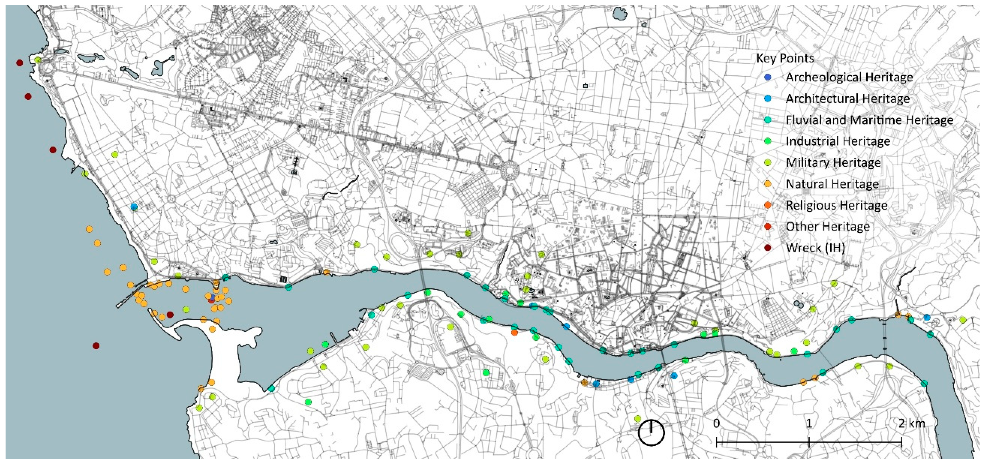
The resulting map (
Figure 6) displays the digitised point features alongside the wrecks identified by the Hydrographic Institute (IH) [
60]. It overlays the digitised historical data onto a modern vector cartographic base, facilitating spatial comparison between the past and the present.
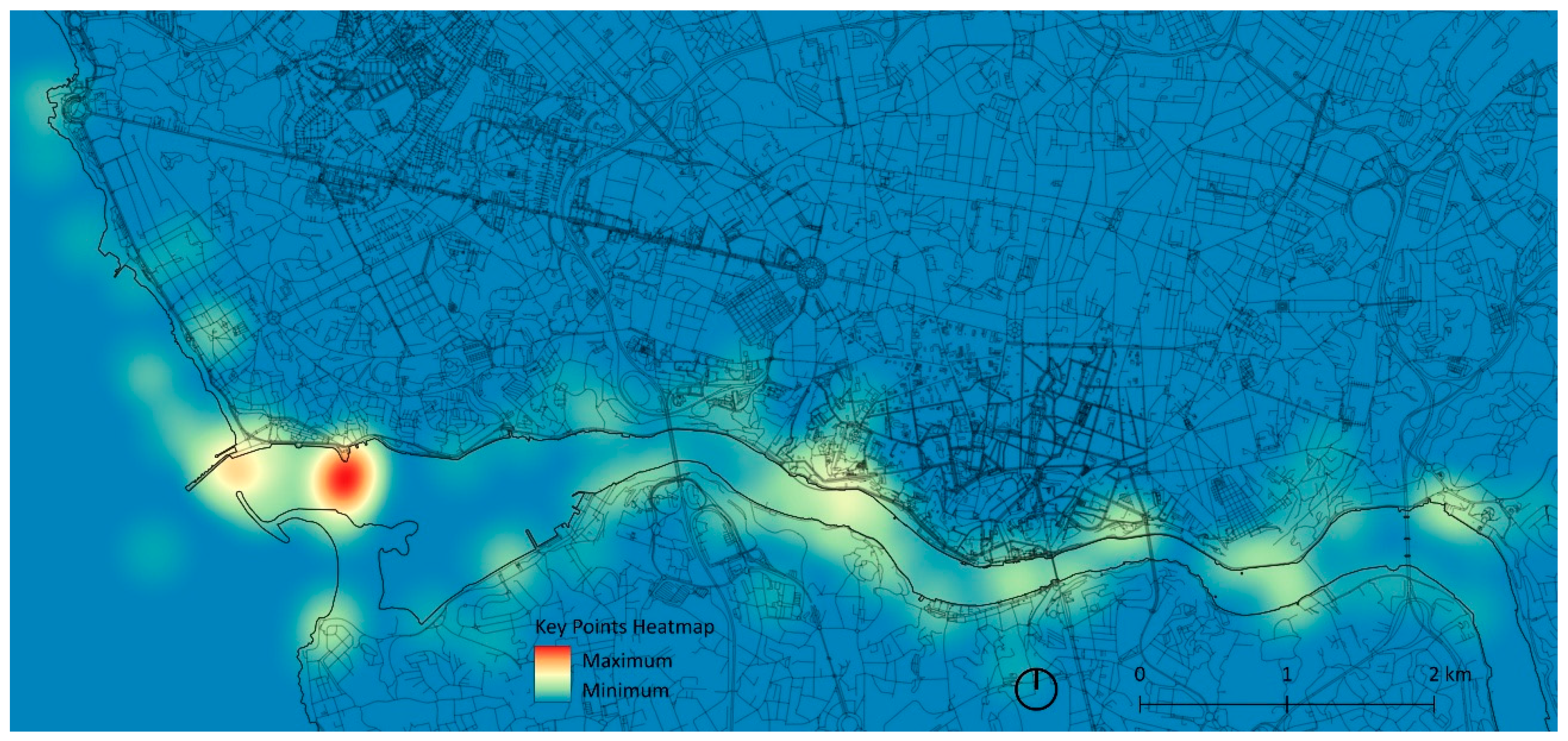
Derived from this map, a hotspot density map was produced in QGIS using the previously identified points and the Kernel Density Estimation (KDE) algorithm. A fixed search radius of 500 m was applied, selected in accordance with the spatial distribution of the digitised features and the scale of the study area, to highlight areas of concentrated archaeological potential (
Figure 7).
A cross-validation between the identified hotspots and the Portuguese Hydrographic Institute open-source shipwreck database [
60] reveals that these records contribute only 11 out of the 138 total feature points used in the model. Notably, only one of these documented wrecks is situated specifically at the Douro River mouth, while the remainder are located further offshore. While this quantitative disparity limits a full statistical validation, the spatial convergence observed between historically derived features and the documented locations supports the internal consistency of the screening framework. Furthermore, despite the abundant historical references to shipwrecks in documentary sources, the scarcity of precise georeferenced records within the river highlights the lack of systematic, geographically based underwater surveys in the Douro. This gap reinforces the value of the proposed geo-historical predictive approach as a primary tool for prioritising and guiding future ground-truthing efforts.
The resulting spatial dataset identifies sectors along the riverbanks and riverbed where underwater heritage remains may be present, including former docks, port infrastructures, shipbuilding areas, known shipwreck locations, and the military defence lines established during the 1832–1833 Siege of Porto.
The spatial differentiation of these hotspot areas suggests distinct categories of potential underwater cultural heritage. Zones historically associated with port and commercial activity may contain remains related to docking infrastructures, anchoring systems, cargo handling, and ship maintenance activities. Areas connected to military defensive structures present potential for artillery elements, structural debris, or conflict-related material culture. In sectors characterised by navigation hazards and documented maritime accidents, the probability of shipwreck remains, and dispersed cargo artefacts is comparatively higher.
From a survey planning perspective, priority should be assigned to areas where intense historical land–water interaction coincides with sedimentary conditions that may favour preservation. These zones constitute strategic targets for future geophysical prospection and in situ verification.
The hotspots should not be interpreted as exact coordinates of known remains but as spatial indicators of archaeological potential derived from historical, topographic, and environmental evidence. For example, certain areas near the mouth of the Douro, historically described as hazardous and difficult to navigate (as shown in
Figure 1,
Figure 2 and
Figure 3), emerge with the highest potential and were identified as priority zones for future underwater surveys. The areas of Massarelos and Ribeira also appear as hotspots, reflecting their historical importance as sites of intense land–river interaction due to their quays. Likewise, sections of the river where artillery was positioned during the Liberal Wars (
Figure 4) were marked for their possible association with submerged remains related to the conflict.
5. Discussion and Conclusions
These maps function as a preliminary predictive framework for directing more precise underwater archaeological surveys, including side-scan sonar and diving campaigns. Their value lies in their ability to integrate fragmented historical evidence into spatially explicit outputs for heritage prospection.
Despite its usefulness, this methodological approach presents limitations. The varying scales and geometric precision of the historical maps influence positional accuracy. Even with careful georeferencing, distortions remain unavoidable, particularly in earlier or more schematic cartographic sources.
Beyond geometric considerations, it is also important to recognise that historical maps are not neutral representations of space. As with other historical documents, cartographic production reflects the social, political, and strategic priorities of the time, and certain features may have been intentionally omitted or selectively represented. Lemke [
61], for example, demonstrates how the omission of African, African American, and Hispanic cemeteries from modern cartographic records in Texas contributed to their marginalisation and physical endangerment. Consequently, the absence of specific elements in the analysed maps cannot be interpreted as evidence of their historical non-existence.
Technical constraints were also present, as some digitised maps were only available at 150 dpi. Additionally, the study did not incorporate physical underwater verification, meaning that the mapped locations represent hypotheses that require future underwater surveys and in situ archaeological verification.
Nevertheless, the resulting maps provide a useful and structured basis for defining investigative priorities and designing targeted survey strategies in underwater heritage management. The approach also highlights the importance of interdisciplinary methodologies, combining historical scholarship, digital technologies, and spatial analysis to reveal past human activities now submerged. Once validated through high-resolution underwater methods, these initial results can support the development of predictive models using machine learning, enabling a more accurate and comprehensive identification of underwater heritage along the Douro River.
Compared with direct geophysical survey techniques, which provide material detection of submerged remains, the present approach does not generate immediate physical evidence. Instead, it functions as a strategic, historically informed screening tool that supports the definition of priority areas for future investigation. In contrast to data-intensive predictive modelling frameworks, this method relies primarily on documentary and cartographic analysis, making it particularly suitable in contexts where systematic underwater inventories remain limited. Thus, rather than replacing other methodologies, the proposed geo-historical approach should be understood as a complementary first step within a broader multi-method research strategy.
The combined use of historical cartography and GIS demonstrates the effectiveness of integrating past landscapes with modern spatial technologies to investigate submerged cultural heritage. Despite variations in cartographic accuracy, historical maps offer essential insights into former coastlines, infrastructures, navigation hazards, and long-term human–river interactions. When georeferenced and critically analysed, they help identify locations with high archaeological potential.
In the case of Porto, this methodology underscores the city’s enduring maritime significance, recurrent shipwreck history, and strategic coastal role. By integrating archaeological literature, documentary sources, and five key historical maps, several sectors along the Douro were identified as having high potential for submerged heritage, including the hazardous river mouth, the historic quays of Massarelos and Ribeira, former shipbuilding areas, and locations associated with 19th-century defence lines.
The production of an interpretative map and subsequent hotspot analysis provides a solid foundation for targeted field surveys and future predictive modelling. Overall, the study shows that historical maps are not only valuable for reconstructing past waterfront landscapes but can also be used as a practical and transferable screening framework to support underwater heritage prospection, management, and survey prioritisation in data-limited contexts.
Future investigations are planned to validate the identified hotspots through non-invasive survey techniques, such as side-scan sonar and targeted bathymetric analysis, subject to funding availability and institutional collaboration. It is also important to acknowledge that the current heatmap reflects the types of features documented in the analysed cartographic and historical sources, which predominantly relate to navigation hazards, port infrastructures, and military activity. Other forms of underwater cultural heritage, including votive deposits, submerged settlement remains, or ritual and everyday objects, may also be present but are less likely to be represented in historical cartography. Consequently, future surveys may reveal additional site types beyond those currently modelled.