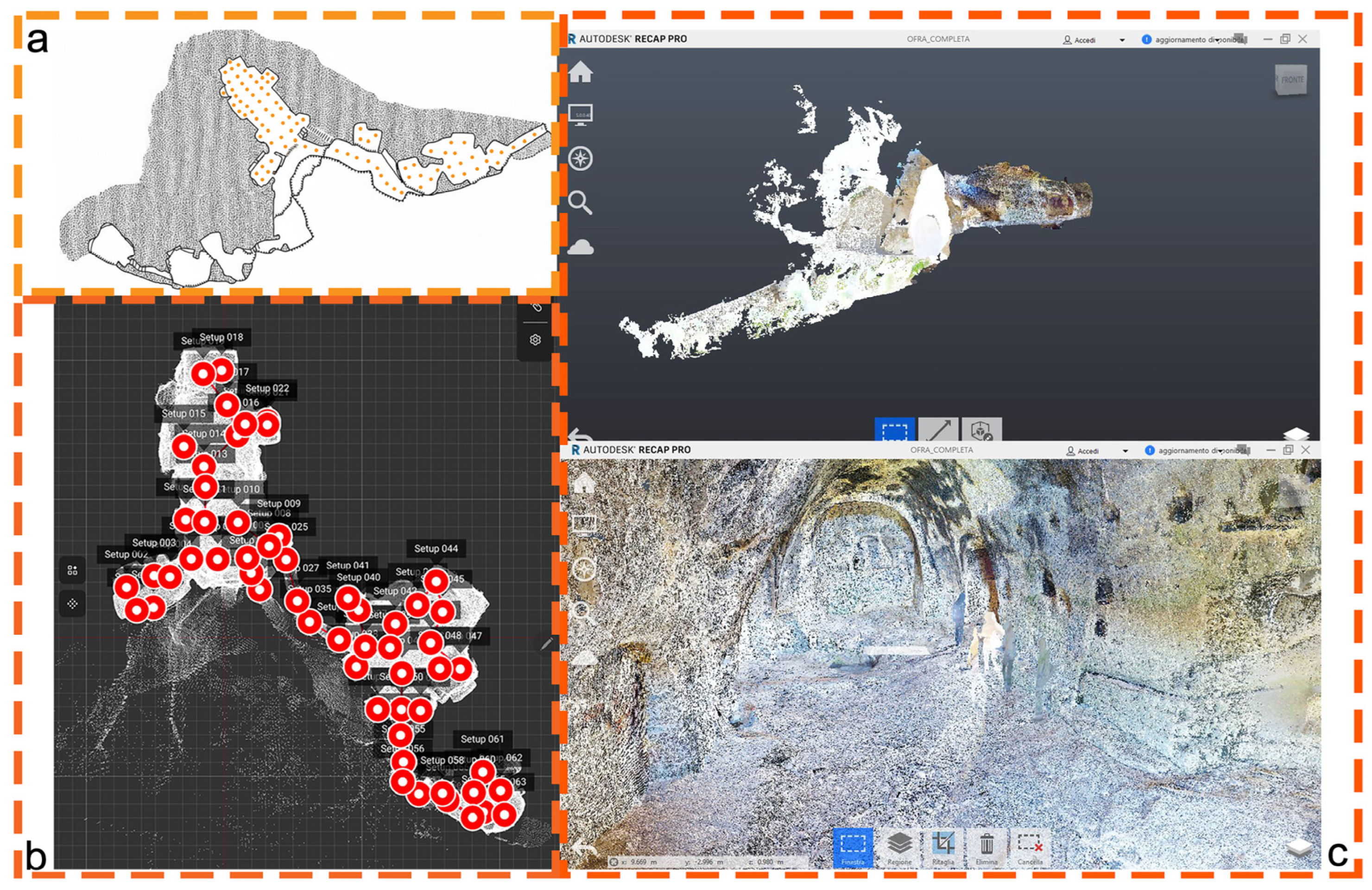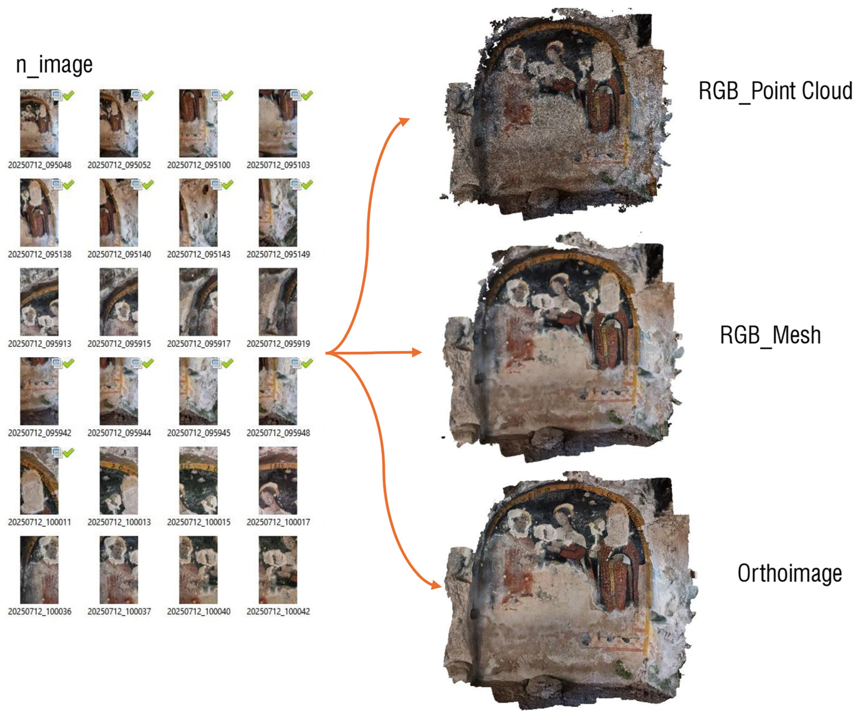

Integrated Digital Environments for the Knowledge and Management of Low-Accessible Cultural Heritage: A Multiscale Web-Based Framework

 , , and
Abstract
1. Introduction
- (i)
- Rupestrian structures, characterized by shallow excavations into exposed rock outcrops. The direct shaping of the rock and the relative simplicity of excavation techniques allow the creation of limited-scale spaces, suitable for residential, cultic, funerary, or small-scale productive functions. The orientation, dimensions, and depth of these spaces are strongly conditioned by the natural morphology of the rock and the local geomorphological context.
- (ii)
- Underground structures, excavated deeply below ground level, where the technical complexity of excavation enables the development of more articulated and functionally diverse spaces. These include cisterns, galleries, hypogeal warehouses, refuges, and complex hydraulic systems, often arranged on multiple interconnected levels [2].
1.1. Literature Review
1.1.1. Digital Technologies for Hypogeal and Low-Accessibility Heritage
1.1.2. Remote Fruition and Immersive Environments
1.1.3. Automation and Artificial Intelligence in Decay Diagnosis
1.1.4. Identification of the Research Gap and Positioning of the Study
2. Materials and Methods
2.1. The Methodological Workflow
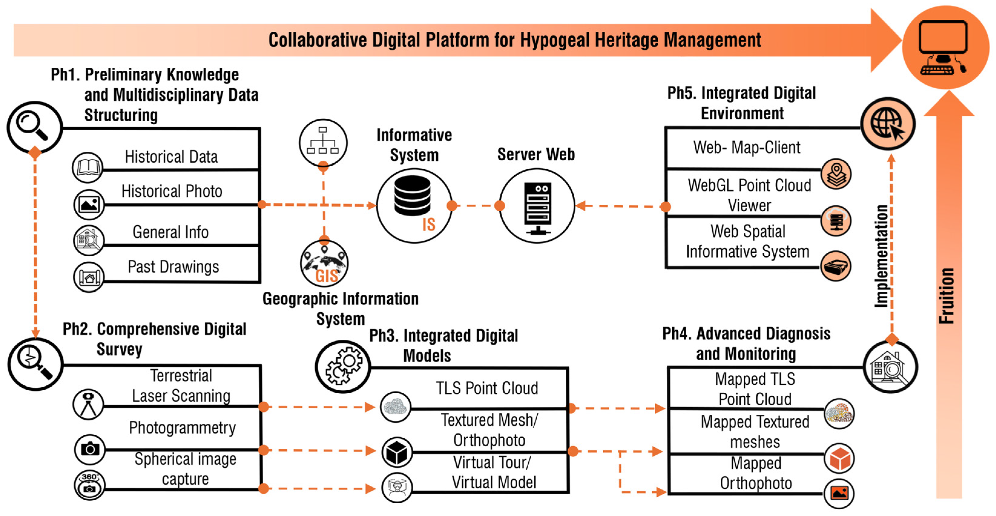
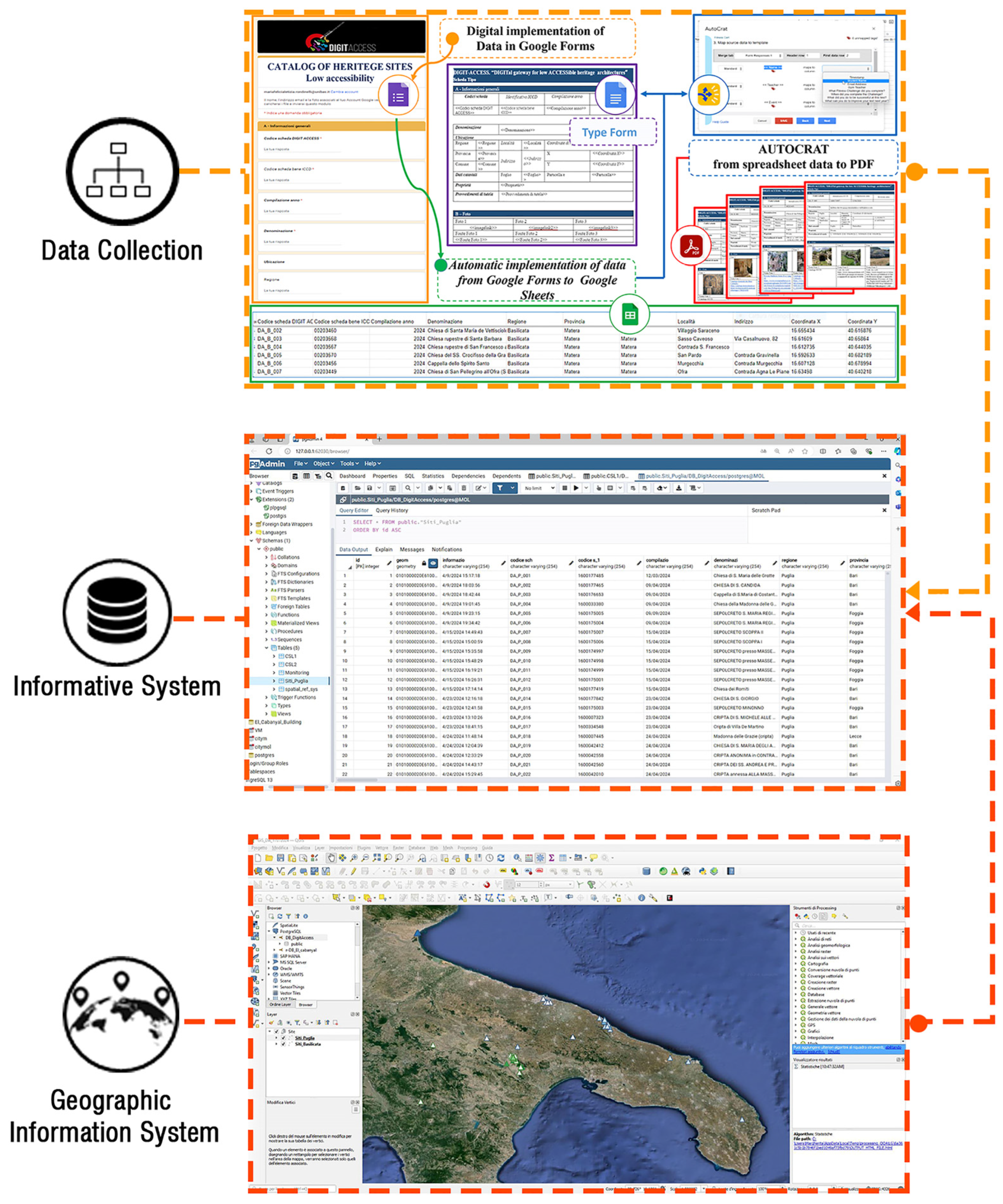
- Ph1. Preliminary Knowledge and Multidisciplinary Data Structuring (PK–MDS), focuses on collecting existing historical, architectural, and archaeological information and organizing it into an integrated framework.Ph2. Comprehensive Digital Survey (CDS), involves the acquisition of high-resolution geometric, colorimetric, and spatial data through advanced survey techniques.Ph3. Development of Integrated Digital Models (IDMs), consists of creating coherent digital and semantic models that combine geometric, material, and descriptive information.Ph4. Advanced Diagnosis and Monitoring (ADM), enables the analysis of conservative conditions and material degradation over time.Ph5. Implementation of an Integrated Digital Environment for Hypogeal Heritage Management (IDE), establishes a collaborative digital platform that supports multi-user access, knowledge sharing, and conservation and management purposes.
2.1.1. Preliminary Knowledge (PK) and Multidisciplinary Data Structuring (MDS)

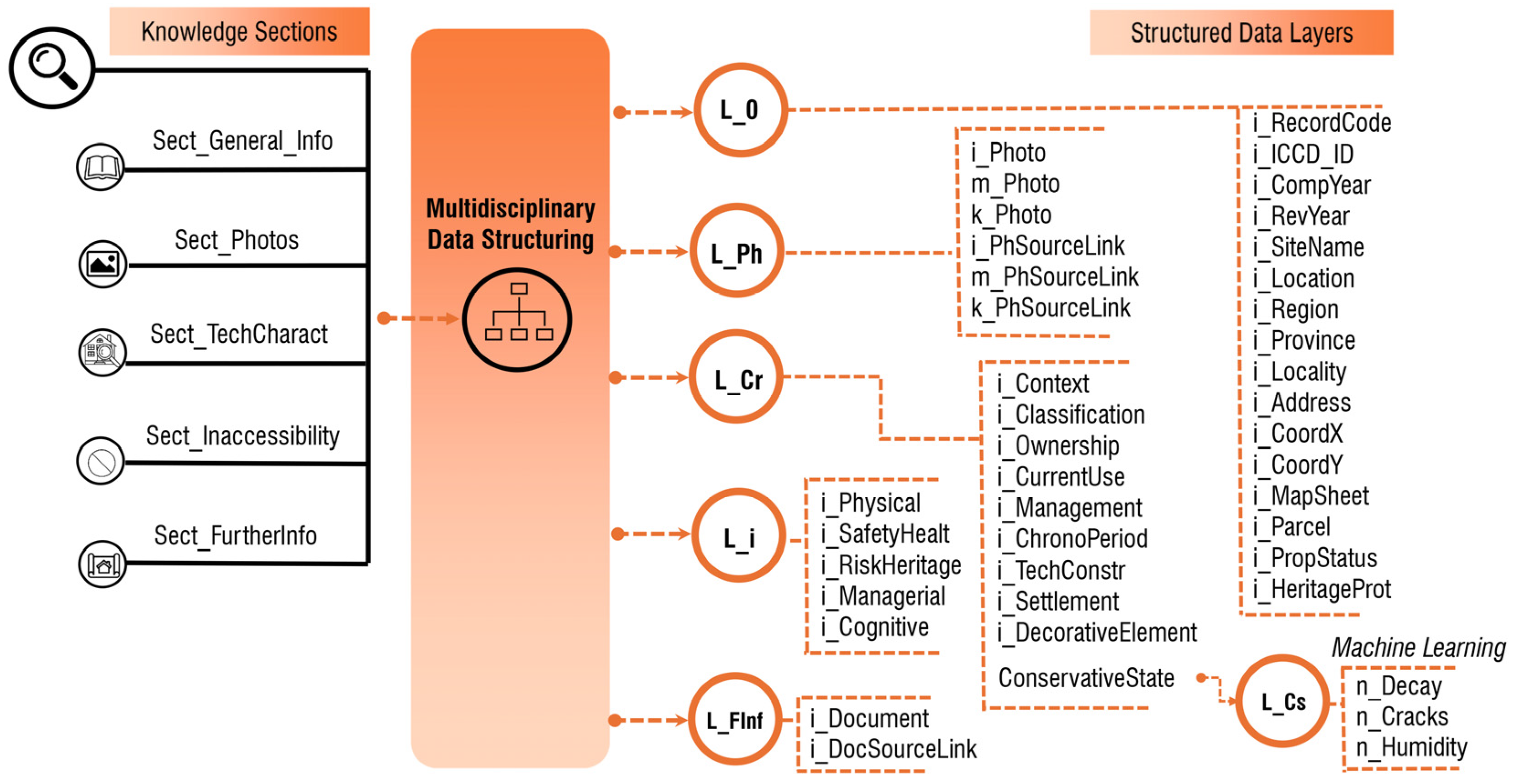
| Attributes | Implementation of Semantic Data in the Digital System/Model | ||||
|---|---|---|---|---|---|
| IS | GIS | TLS_Cloud | VT | VM | |
| i_RecordCode | Text | Text | Sheet (.pdf) | Sheet (.pdf) | |
| i_ICCD_ID | Text | Text | Sheet (.pdf) | Sheet (.pdf) | |
| i_CompYear | Integer | Integer | Sheet (.pdf) | Sheet (.pdf) | |
| i_RevYear | Integer | Integer | Sheet (.pdf) | Sheet (.pdf) | |
| i_SiteName | Text | Text | Sheet (.pdf) | Sheet (.pdf) | |
| i_Location | Text | Text | Sheet (.pdf) | Sheet (.pdf) | |
| i_Region | Text | Text | Sheet (.pdf) | Sheet (.pdf) | |
| i_Province | Text | Text | Sheet (.pdf) | Sheet (.pdf) | |
| i_Locality | Text | Text | Sheet (.pdf) | Sheet (.pdf) | |
| i_Address | Text | Text | Sheet (.pdf) | Sheet (.pdf) | |
| i_CoordX | Geometry (Point) | Geometry (Point, .shp) | Sheet (.pdf) | Sheet (.pdf) | |
| i_CoordY | Geometry (Point) | Geometry (Point, .shp) | Sheet (.pdf) | Sheet (.pdf) | |
| i_MapSheet | Integer | Integer | Sheet (.pdf) | Sheet (.pdf) | |
| i_Parcel | Integer | Integer | Sheet (.pdf) | Sheet (.pdf) | |
| i_PropStatus | Text | Text | Sheet (.pdf) | Sheet (.pdf) | |
| i_Heritage Prot | Text | Text | Sheet (.pdf) | Sheet (.pdf) | |
| i_nPhoto | Image (.jpeg, .png, .tif) | Image (.jpeg, .png, .tif) | Sheet (.pdf) | Sheet (.pdf) | |
| i_nPhSource Link | Text (URL) | Text (URL) | Sheet (.pdf) | Sheet (.pdf) | |
2.1.2. Comprehensive Digital Survey (CDS)
2.1.3. Integrated Digital Models (IDMs)
2.1.4. Advanced Diagnosis and Monitoring (ADM)
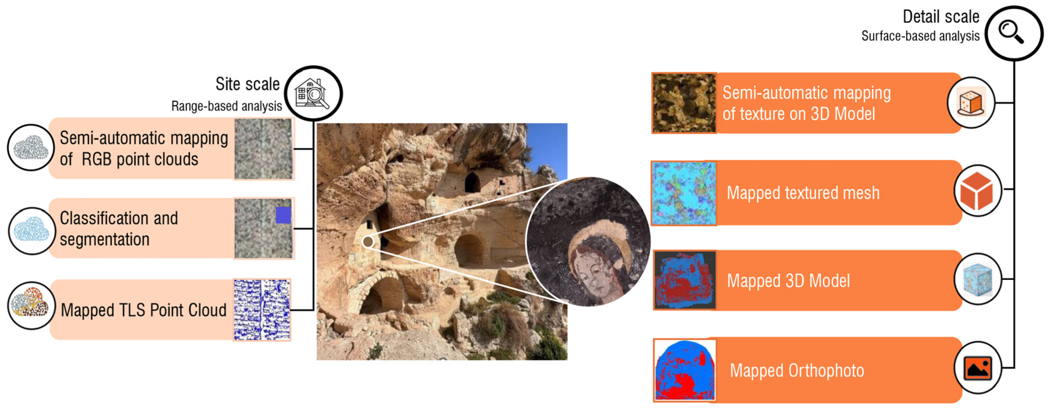
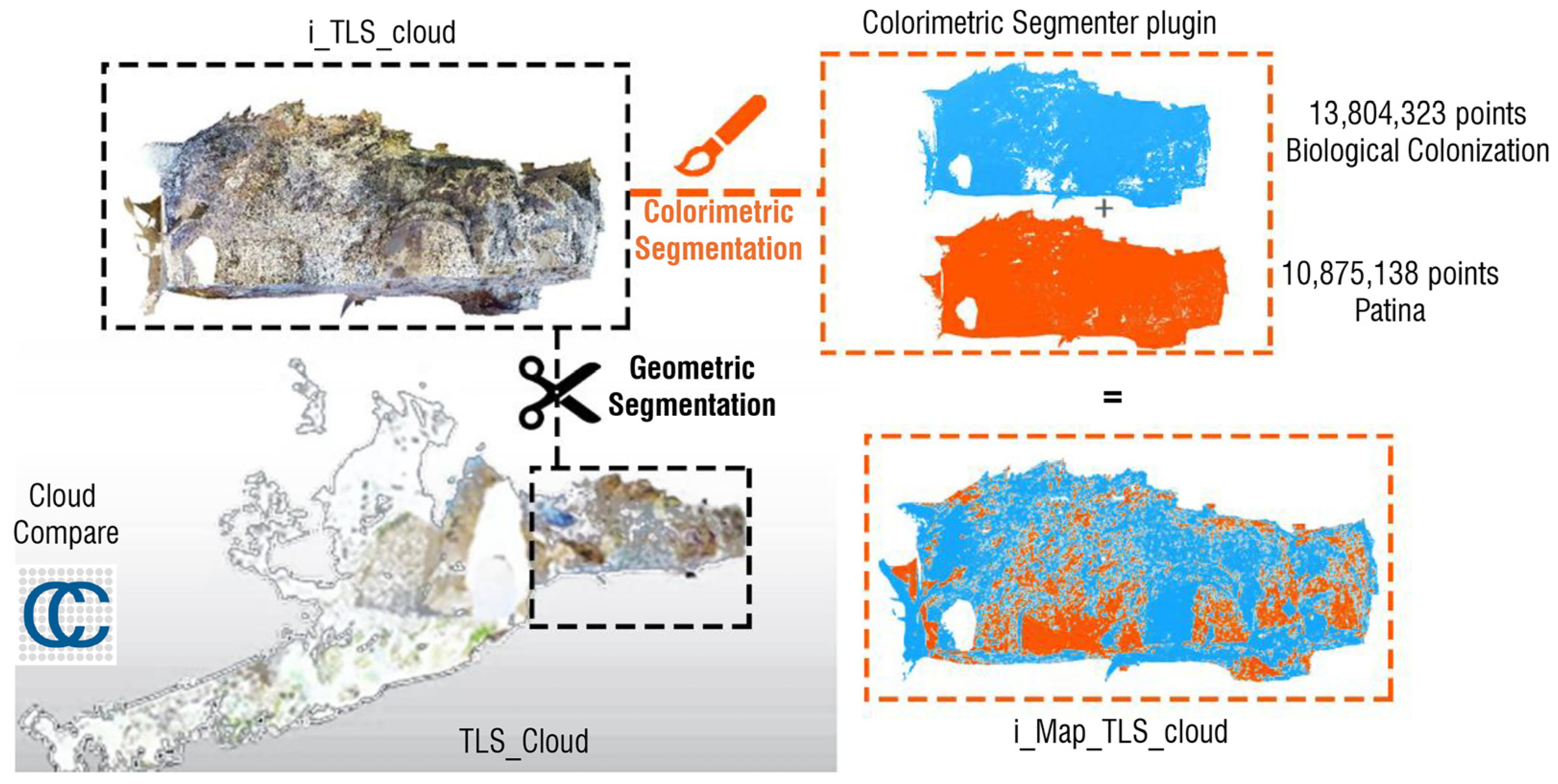
Decay Mapping at the Site Scale
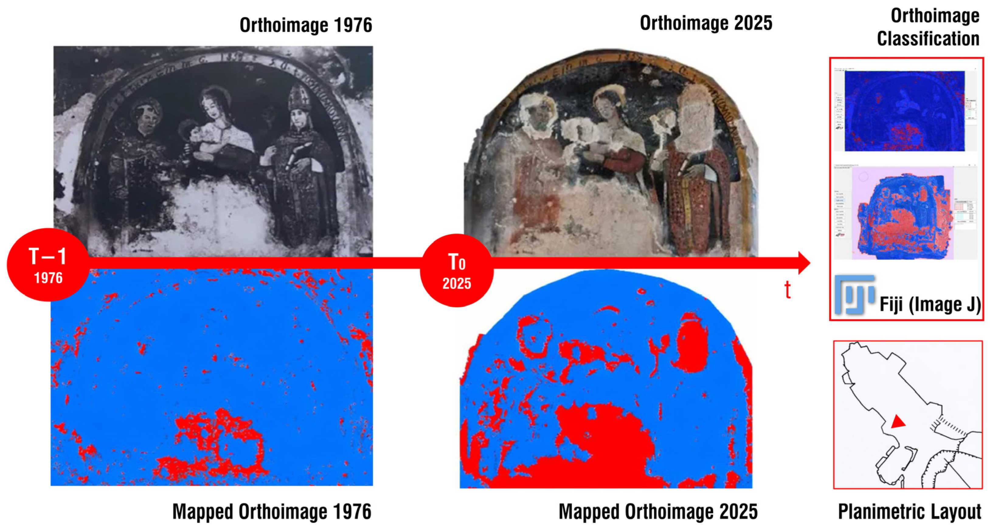
Diachronic Analysis of Decorative Elements
2.1.5. Integrated Digital Environment for Hypogeal Heritage Management
3. Results
3.1. Multi-Site Implementation of the Knowledge Structuring Phase
3.2. Methodological Workflow Applied to the San Pellegrino Rupestrian Complex
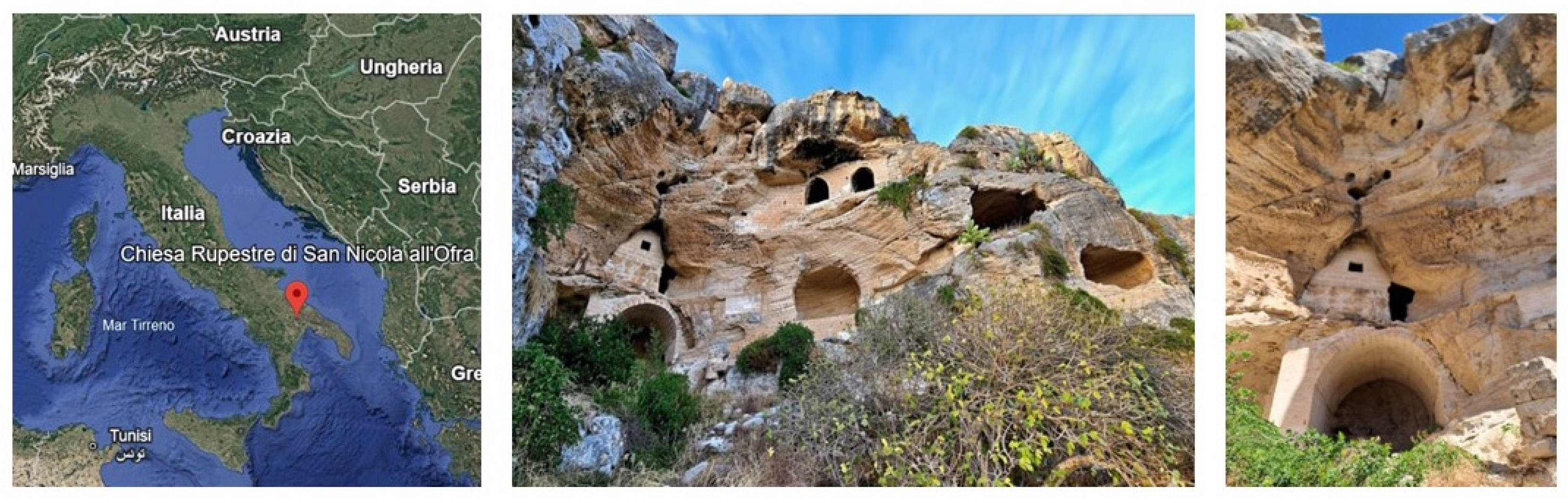
3.2.1. Historical Context
3.2.2. Detailed Diagnosis and Monitoring Workflow for a Representative Hypogeal Site
4. Discussion
5. Conclusions
Author Contributions
Funding
Data Availability Statement
Acknowledgments
Conflicts of Interest
Abbreviations
| ADM | Advanced Diagnosis and Monitoring |
| CDS | Comprehensive Digital Survey |
| CS | Conservative State |
| GIS | Geographic Information System |
| IDE | Integrated Digital Environment |
| IDMs/IDM | Integrated Digital Models |
| IS | Informative System |
| IVE | Integrated Virtual Environments |
| Map_Ortho | Mapped Orthophoto |
| Map_RGB_Mesh | Mapped |
| Map_TLS_cloud | Mapped Terrestrial laser scanning point cloud datasets |
| MDS | Multidisciplinary Data Structuring |
| MW | Methodological Workflow |
| PK | Preliminary Knowledge |
| RGB_Mesh | Textured mesh models generated from photogrammetric data |
| S_TK | Structuring of Technical Knowledge |
| Shp_image | Spherical image |
| SP | Survey Plan |
| TLS | Terrestrial laser scanning |
| TLS_Cloud | Terrestrial laser scanning point cloud datasets |
| UAVs | Unmanned Aerial Vehicles |
| VMs/VM | Virtual Models |
| VTs | Virtual Tours |
References
- Varriale, R. “Underground Built Heritage”: A theoretical approach for the definition of an international class. Heritage 2021, 4, 1092–1118. [Google Scholar] [CrossRef]
- Bixio, R.; De Pascale, A.; Galeazzi, C.; Parise, M. Rupestrian Works and Artificial Cavities: Categories of Construction Techniques. J. Arch. Eng. Res. 2023, 4, 59–68. [Google Scholar] [CrossRef]
- Varriale, R. Underground Built Heritage. Encyclopedia 2025, 5, 92. [Google Scholar] [CrossRef]
- Corrao, R.; Di Paola, F.; Termini, D.; Vinci, C. Investigation of the underground building heritage and the mechanism of water flowing in Qanāts in Palermo through innovative surveying techniques. Int. Arch. Photogramm. Remote Sens. Spat. Inf. Sci. 2021, 46, 147–154. [Google Scholar] [CrossRef]
- Lasorella, M.; Cantatore, E.; Fatiguso, F. Smart approaches to enhance technical knowledge of in/low-accessible heritage. SCIRES-IT-Sci. Res. Inf. Technol. 2021, 11, 97–112. [Google Scholar]
- De Fino, M.; Galantucci, R.A.; Fatiguso, F. Condition Assessment of Heritage Buildings via Photogrammetry: A Scoping Review from the Perspective of Decision Makers. Heritage 2023, 6, 7031–7066. [Google Scholar] [CrossRef]
- Scianna, A.; Gaglio, G.F.; La Guardia, M. Augmented virtual accessibility of ch: The web navigation model of inquisition prisons. Int. Arch. Photogramm. Remote. Sens. Spat. Inf. Sci. 2023, 48, 1443–1447. [Google Scholar] [CrossRef]
- Piscitelli, M. From 3D scanning to Virtual Tours for the fruition of Architectural Heritage. The Church of Santa Maria della Purità. SCIRES-IT-Sci. Res. Inf. Technol. 2023, 12, 55–68. [Google Scholar]
- Gaspari, F.; Barbieri, F.; Fascia, R.; Ioli, F.; Pinto, L. An open-source web platform for 3D documentation and storytelling of hidden cultural heritage. Heritage 2024, 7, 517–536. [Google Scholar] [CrossRef]
- Bartolini, G.; De Falco, A.; Gianfranceschi, L.; Martino, M.; Vignali, L. The Heritage Building Information Modeling Methodology for Structural Diagnosis: An Integrated System of Digital Models for the Baptistery of San Giovanni in Pisa. Heritage 2024, 7, 6366–6391. [Google Scholar] [CrossRef]
- Okanovic, V.; Ivkovic-Kihic, I.; Boskovic, D.; Mijatovic, B.; Prazina, I.; Skaljo, E.; Rizvic, S. Interaction in extended reality applications for cultural heritage. Appl. Sci. 2022, 12, 1241. [Google Scholar] [CrossRef]
- Sánchez-Aparicio, L.J.; del Blanco-García, F.L.; Mencías-Carrizosa, D.; Villanueva-Llauradó, P.; Aira-Zunzunegui, J.R.; Sanz-Arauz, D.; Pierdicca, R.; Pinilla-Melo, J.; Garcia-Gago, J. Detection of damage in heritage constructions based on 3D point clouds. A systematic review. J. Build. Eng. 2023, 77, 107440. [Google Scholar] [CrossRef]
- Giannuzzi, V.; Fatiguso, F. Historic Built Environment Assessment and Management by Deep Learning Techniques: A Scoping Review. Appl. Sci. 2024, 14, 7116. [Google Scholar] [CrossRef]
- Dionizio, R.F.; Marques, C.K.B.; Dezen-Kempter, E. BIM-GIS application for documenting and promoting archaeological heritage. Appl. Geomat. 2025, 17, 693–710. [Google Scholar] [CrossRef]
- Yang, S.; Xu, S.; Huang, W. 3D point cloud for cultural heritage: A scientometric survey. Remote. Sens. 2022, 14, 5542. [Google Scholar] [CrossRef]
- Lasorella, M.; De Fino, M.; Rondinelli, M.F.L.; Guida, A.; Fatiguso, F. Accessibility of hypogeal heritage: Identification of key factors by case study cataloguing and text mining. In Proceedings of EDMSET 2025; Springer: Cham, Switzerland, 2026. [Google Scholar]
- Casarotto, A.; Fiorentino, S.; Vandini, M. An Approach to Risk Assessment and Planned Preventative Maintenance of Cultural Heritage: The Case of the Hypogeum Archaeological Site of Sigismund Street (Rimini, Italy). Heritage 2025, 8, 344. [Google Scholar] [CrossRef]
- D’agostino, G.; Figuera, M.; Russo, G.; Galizia, M.; Militello, P.M. Integrated 3D survey for the documentation and visualization of a rock-cut underground built heritage. Int. Arch. Photogramm. Remote. Sens. Spat. Inf. Sci. 2022, 46, 167–174. [Google Scholar] [CrossRef]
- Galera-Rodríguez, A.; Angulo-Fornos, R.; Algarín-Comino, M. Survey and 3D modelling of underground heritage spaces with complex geometry: Surface optimisation for association with HBIM methodology. SCIRES-IT-Sci. Res.-Form. Technol. 2022, 12, 177–190. [Google Scholar]
- Tanasi, D.; Hassam, S.; Kingsland, K. Underground Archaeology: Photogrammetry and Terrestrial Laser Scanning of the Hypogeum of Crispia Salvia (Marsala, Italy). In International Conference on Pattern Recognition; Springer International Publishing: Cham, Switzerland, 2021; pp. 353–367. [Google Scholar]
- Luvidi, L.; Prestileo, F.; De Paoli, M.; Riminesi, C.; Del Fà, R.M.; Magrini, D.; Fratini, F. Diagnostics and monitoring to preserve a hypogeum site: The case of the mithraeum of Marino Laziale (Rome). Heritage 2021, 4, 4264–4285. [Google Scholar] [CrossRef]
- Frasca, F.; Verticchio, E.; Caratelli, A.; Bertolin, C.; Camuffo, D.; Siani, A.M. A comprehensive study of the microclimate-induced conservation risks in hypogeal sites: The mithraeum of the baths of Caracalla (Rome). Sensors 2020, 20, 3310. [Google Scholar] [CrossRef]
- D’Orazio, M.; Quagliarini, E.; Bernardini, G.; Gregorini, B.; Gianangeli, A. Sustainable fruition as a preventive conservation strategy for hypogeum artefacts. J. Cult. Herit. 2020, 46, 235–243. [Google Scholar] [CrossRef]
- Aricò, M.; La Guardia, M.; Brutto, M.L. 3D Data Integration for Web Fruition of Underground Archaeological Sites: A Web Navigation System for the Hypogeum of Crispia salvia (Marsala, Italy). Heritage 2023, 6, 5899–5918. [Google Scholar] [CrossRef]
- Trizio, I.; Brusaporci, S.; Luigini, A.; Ruggieri, A.; Basso, A.; Maiezza, P.; Tata, A.; Giannangeli, A. Experiencing the inaccessible. a framework for virtual interpretation and visualization of remote, risky or restricted access heritage places. Int. Arch. Photogramm. Remote. Sens. Spat. Inf. Sci. 2019, 42, 1171–1178. [Google Scholar] [CrossRef]
- Cantatore, E.; Lasorella, M.; Fatiguso, F. Virtual reality to support technical knowledge in cultural heritage. the case study of cryptoporticus in the archaeological site of Egnatia (Italy). Int. Arch. Photogramm. Remote. Sens. Spat. Inf. Sci. 2020, 44, 465–472. [Google Scholar] [CrossRef]
- Gabellone, F.; Masini, N. VR/AR based data integration for the diagnosis of the state of conservation of the Convento do Carmo. Towards a digital twin of architectural heritage. In Heritage Within (HWITHIN); New techniques for the inspection, recon-struction and presentation of the non-visible parts of the built cultural heritage; Ortega, J., Ed.; Sersilito-Empresa Gráfica: Maia, Portugal, 2021; pp. 101–115. [Google Scholar]
- Galantucci, R.A.; Musicco, A.; Verdoscia, C.; Fatiguso, F. Machine learning for the semi-automatic 3D decay segmentation and mapping of heritage assets. Int. J. Arch. Herit. 2025, 19, 389–407. [Google Scholar] [CrossRef]
- Zhang, G.; Dou, X.; Li, L. Intelligent Defect Detection of Ancient City Walls Based on Computer Vision. Sensors 2025, 25, 5042. [Google Scholar] [CrossRef] [PubMed]
- Nespeca, R.; Mariotti, C.; Petetta, L.; Mandriota, A. Point cloud segmentation in heritage preservation. advanced digital process for historical houses. Int. Arch. Photogramm. Remote. Sens. Spat. Inf. Sci. 2024, 48, 325–332. [Google Scholar] [CrossRef]
- Gbran, H.; Rukayah, S.; Suprapti, A.; Pandelaki, E.E. A Hybrid Framework Employing Deep Learning for 3D Decay Segmentation and Adaptive Mapping of Heritage Structures: Insights from an Experiment. Int. Soc. Study Vernac. Settl. 2025, 12, 101–135. [Google Scholar] [CrossRef]
- Vandenabeele, L.; Loverdos, D.; Pfister, M.; Sarhosis, V. Deep learning for the segmentation of large-scale surveys of historic masonry: A new tool for building archaeology applied at the Basilica of St Anthony in Padua. Int. J. Arch. Herit. 2023, 18, 1749–1761. [Google Scholar] [CrossRef]
- Nieto-Julián, E.; Robador, M.D.; Moyano, J.; Bruno, S. Semantic HBIM for Heritage Conservation: A Methodology for Mapping Deterioration and Structural Deformation in Historic Envelopes. Buildings 2025, 15, 1990. [Google Scholar] [CrossRef]
- Kotsopoulos, K.I.; Chourdaki, P.; Tsolis, D.; Antoniadis, R.; Pavlidis, G.; Assimakopoulos, N. An authoring platform for developing smart apps which elevate cultural heritage experiences: A system dynamics approach in gamification. J. Ambient. Intell. Humaniz. Comput. 2019, 15, 1679–1695. [Google Scholar] [CrossRef]
- Bruno, S.; Scioti, A.; Pierucci, A.; Rubino, R.; Di Noia, T.; Fatiguso, F. Verbum–Virtual enhanced reality for building modelling (virtual technical tour in digital twins for building conservation). J. Inf. Technol. Constr. 2022, 27, 20–47. [Google Scholar] [CrossRef]
- Lionetti, G.; Pelosi, M. Il Complesso Rupestre di San Pellegrino in Contrada Ofra a Matera. In MATHERA Rivista Trimestrale di Storia e Cultura del Territorio; Volume 21; set/20 dic 2018, no. 10, pp. 38–54, September 2018. Available online: https://www.rivistamathera.it/wp-content/uploads/2019/09/Lionetti-Pelosi-Il-complesso-rupestre-di-San-Pellegrino-in-contrada-Ofra-a-Matera.pdf (accessed on 10 September 2025).
- Lasorella, M.; Cantatore, E.; Rondinelli, M.F.L.; Fatiguso, F. A Semi-automatic Pipeline for the Decay Mapping and the State of Conservation Assessment of Architectural Heritage Through Point Clouds. In International Conference on Advanced Research in Technologies, Information, Innovation and Sustainability; Springer: Berlin/Heidelberg, Germany, 2024; pp. 52–67. [Google Scholar]







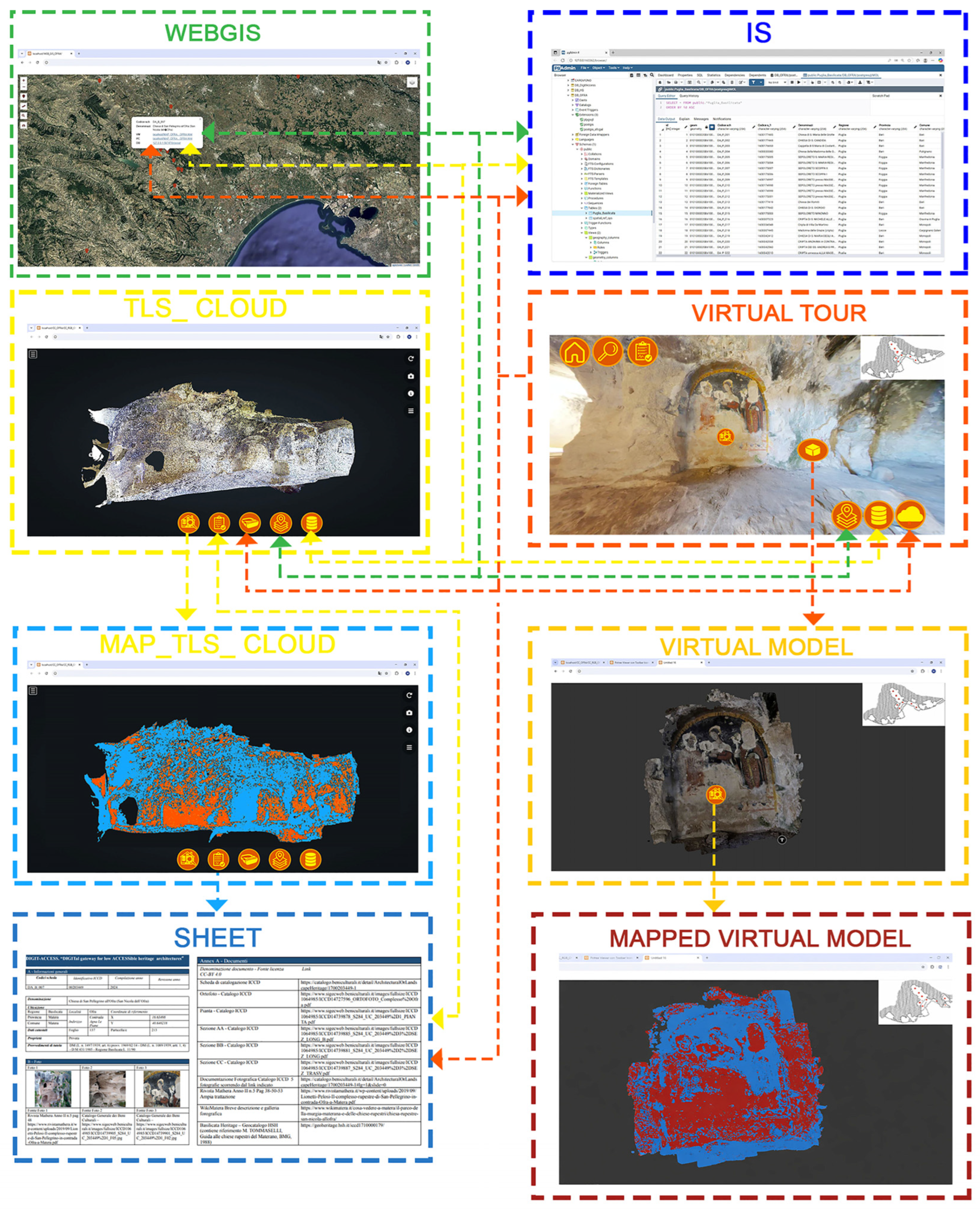
| Attributes | Implementation of Semantic Data in the Digital System/Model | ||||
|---|---|---|---|---|---|
| IS | GIS | TLS_Cloud | VT | VM | |
| i_Context | Text | Text | Sheet (.pdf) | Sheet (.pdf) | |
| i_Classification | Text | Text | Sheet (.pdf) | Sheet (.pdf) | |
| i_Ownership | Text | Text | Sheet (.pdf) | Sheet (.pdf) | |
| i_CurrentUse | Text | Text | Sheet (.pdf) | Sheet (.pdf) | |
| i_Managment | Text | Text | Sheet (.pdf) | Sheet (.pdf) | |
| i_ChronoPeriod | Text | Text | Sheet (.pdf) | Sheet (.pdf) | |
| i_TechConstr | Text | Text | Sheet (.pdf) | Sheet (.pdf) | |
| i_Settlement | Text | Text | Sheet (.pdf) | Sheet (.pdf) | |
| i_Decorative Element | Text | Text | Sheet (.pdf) | Sheet (.pdf) | |
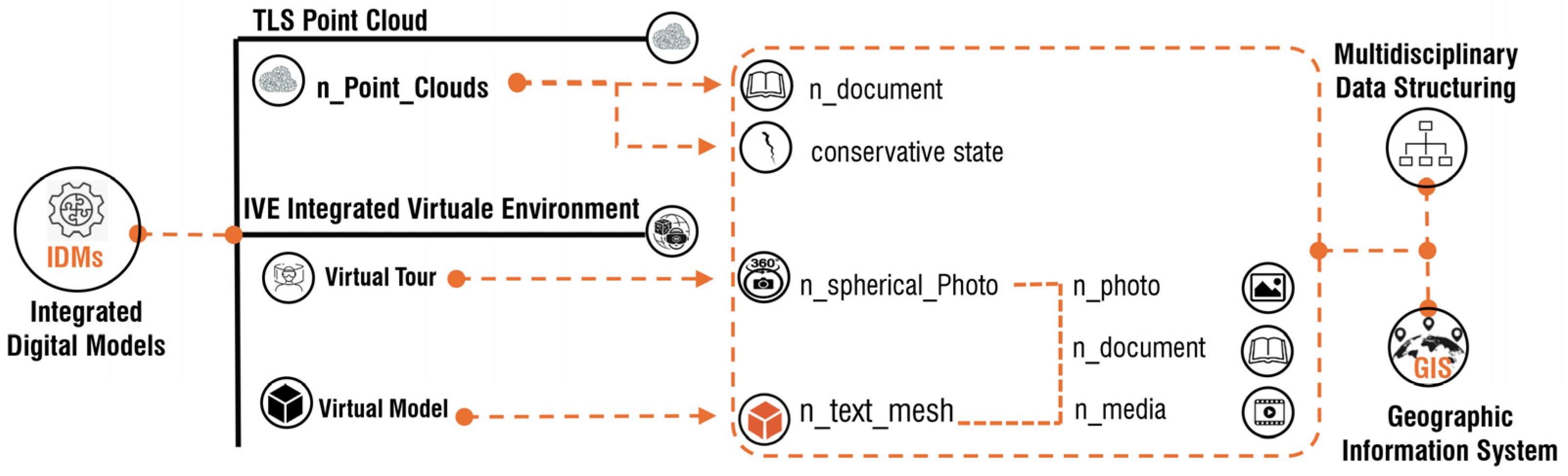
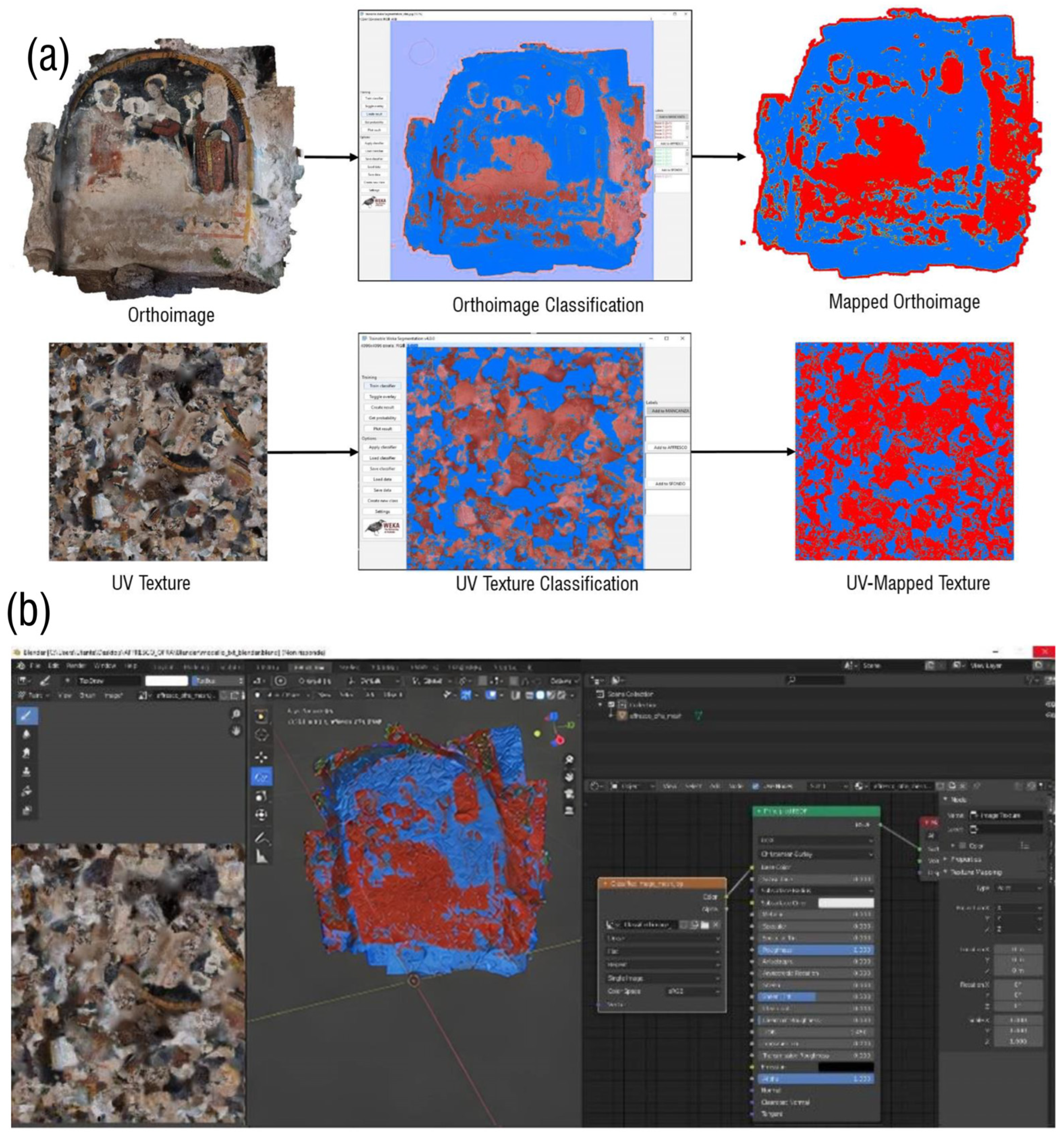
| ConservativeState | Text | Text | TLS_mapped_cloud (.LAS, .E57, .ply, .pts) | TLS_map_plt (.LAS, .E57, .ply, .pts) Map_ Orthoph (.jpeg) | Map_Orthoph (.jpeg) Map_txt (.obj, .ply, .fbx, .gltf, .glb) |
| i_Physical | Text | Text | Sheet (.pdf) | Sheet (.pdf) | |
| i_SafetyHealt | Text | Text | Sheet (.pdf) | Sheet (.pdf) | |
| i_RiskHeritage | Text | Text | Sheet (.pdf) | Sheet (.pdf) | |
| i_Managerial | Text | Text | Sheet (.pdf) | Sheet (.pdf) | |
| i_Cognitive | Text | Text | Sheet (.pdf) | Sheet (.pdf) | |
| i_Document | Text | Text | Sheet (.pdf) | Sheet (.pdf) | |
| i_DocSourceLink | Text (URL) | Text (URL) | Sheet (.pdf) | Sheet (.pdf) | |
Disclaimer/Publisher’s Note: The statements, opinions and data contained in all publications are solely those of the individual author(s) and contributor(s) and not of MDPI and/or the editor(s). MDPI and/or the editor(s) disclaim responsibility for any injury to people or property resulting from any ideas, methods, instructions or products referred to in the content. |
© 2026 by the authors. Licensee MDPI, Basel, Switzerland. This article is an open access article distributed under the terms and conditions of the Creative Commons Attribution (CC BY) license.
Share and Cite
Lasorella, M.; Rondinelli, M.F.L.; Guida, A.; Fatiguso, F. Integrated Digital Environments for the Knowledge and Management of Low-Accessible Cultural Heritage: A Multiscale Web-Based Framework. Heritage 2026, 9, 133. https://doi.org/10.3390/heritage9040133
Lasorella M, Rondinelli MFL, Guida A, Fatiguso F. Integrated Digital Environments for the Knowledge and Management of Low-Accessible Cultural Heritage: A Multiscale Web-Based Framework. Heritage. 2026; 9(4):133. https://doi.org/10.3390/heritage9040133
Chicago/Turabian StyleLasorella, Margherita, Maria Felicia Letizia Rondinelli, Antonella Guida, and Fabio Fatiguso. 2026. "Integrated Digital Environments for the Knowledge and Management of Low-Accessible Cultural Heritage: A Multiscale Web-Based Framework" Heritage 9, no. 4: 133. https://doi.org/10.3390/heritage9040133
APA StyleLasorella, M., Rondinelli, M. F. L., Guida, A., & Fatiguso, F. (2026). Integrated Digital Environments for the Knowledge and Management of Low-Accessible Cultural Heritage: A Multiscale Web-Based Framework. Heritage, 9(4), 133. https://doi.org/10.3390/heritage9040133