
Fields in the Forest Roman Land Division Between Siscia and Andautonia Through LIDAR Data Analysis


Abstract
1. Introduction
2. Materials and Methods
2.1. Study Area

2.2. Materials and Methods
2.3. LIDAR Data and Visualization
- Hillshade model: 35° zenith angle, 315° azimuth.
- Multi-directional hillshade model: 16 directions, 20° sun elevation.
- Simple local relief model (SLRM): 20 m search radius.
- Slope
2.4. Study Area and Scale
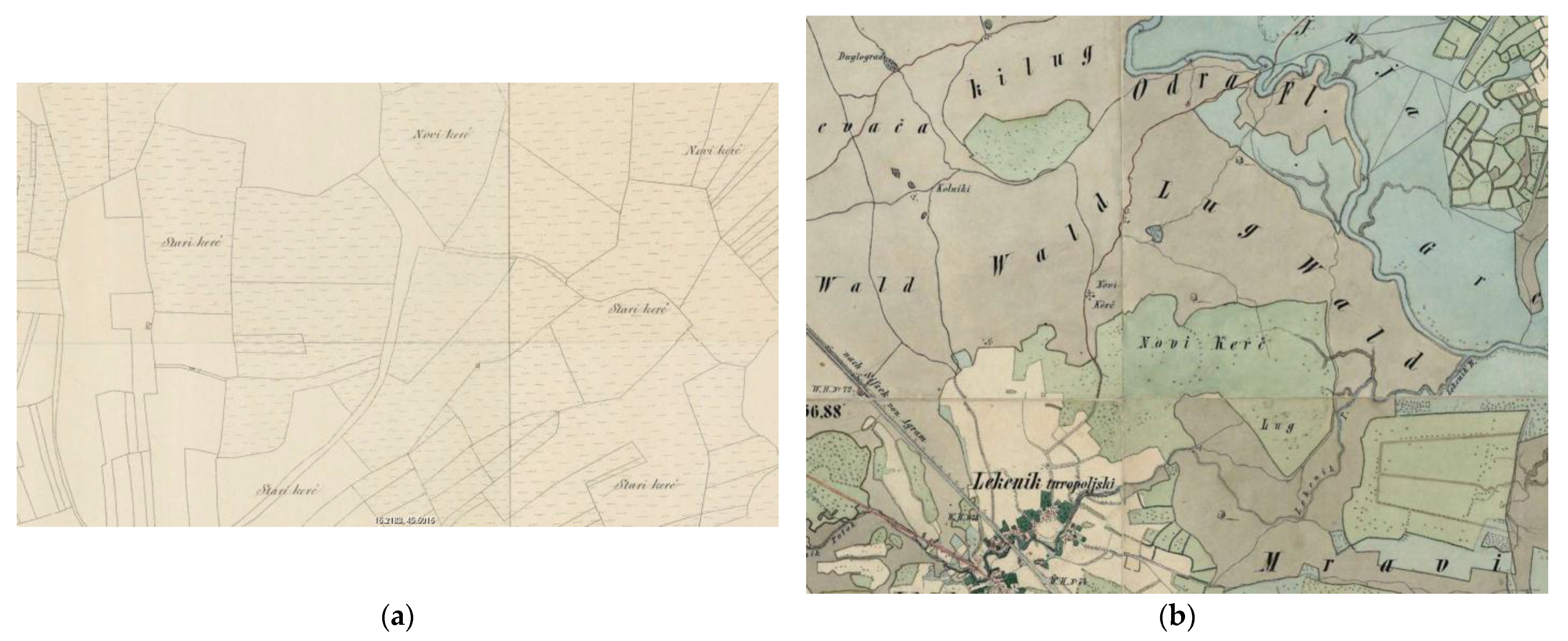
2.5. Archaeological and Historical Data Integration
- Tracing the historical extent of forest cover.
- Identifying shifts in landscape use and toponymy.
- Understanding long-term changes in the visibility and preservation of archaeological features.
2.6. Analytical Integrated Approach
- Remote sensing and visualization of topographic features for archaeological interpretation.
- Comparative cartographic analysis to evaluate landscape transformation over time.
- Cross-referencing archaeological literature to validate the identification of tumuli and centuriation elements.
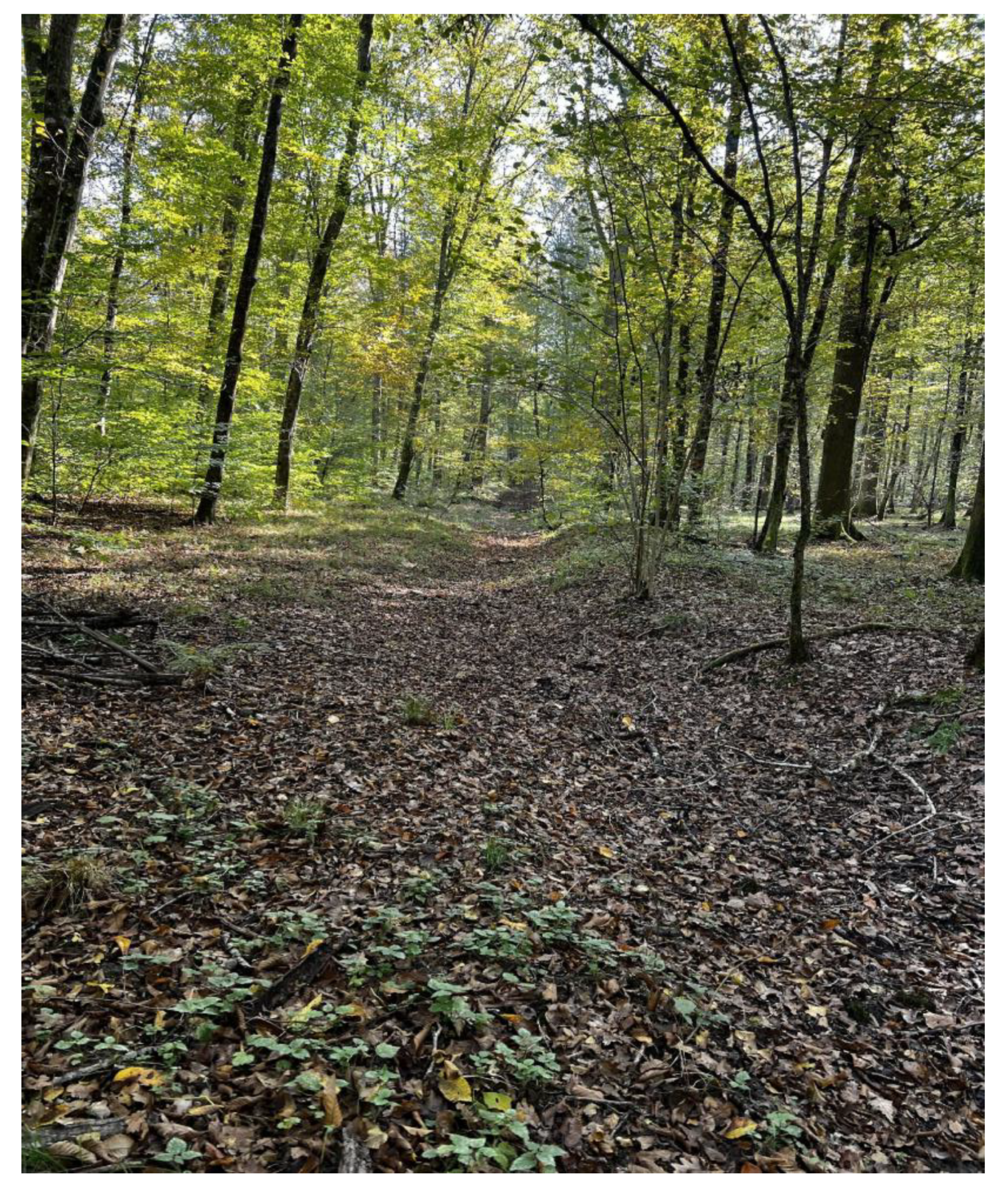
2.7. Field Surveys
3. Results
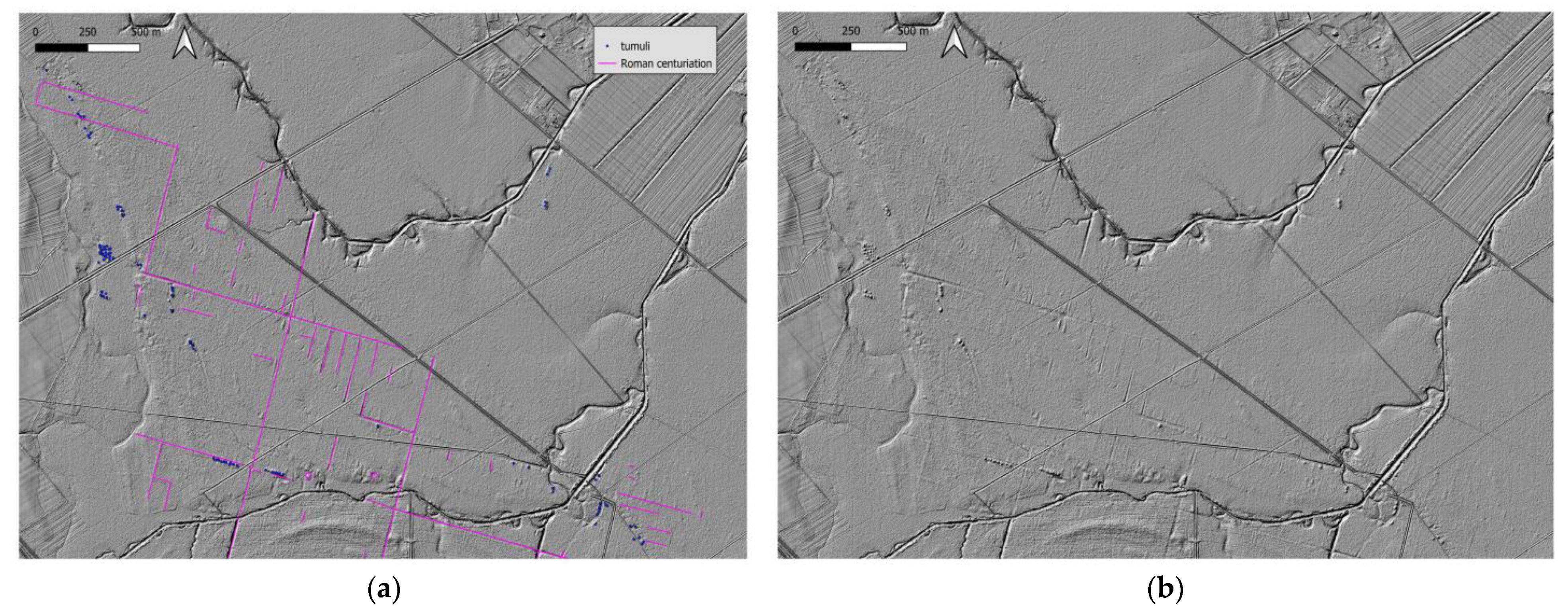
3.1. Tumuli
3.2. Centuriation
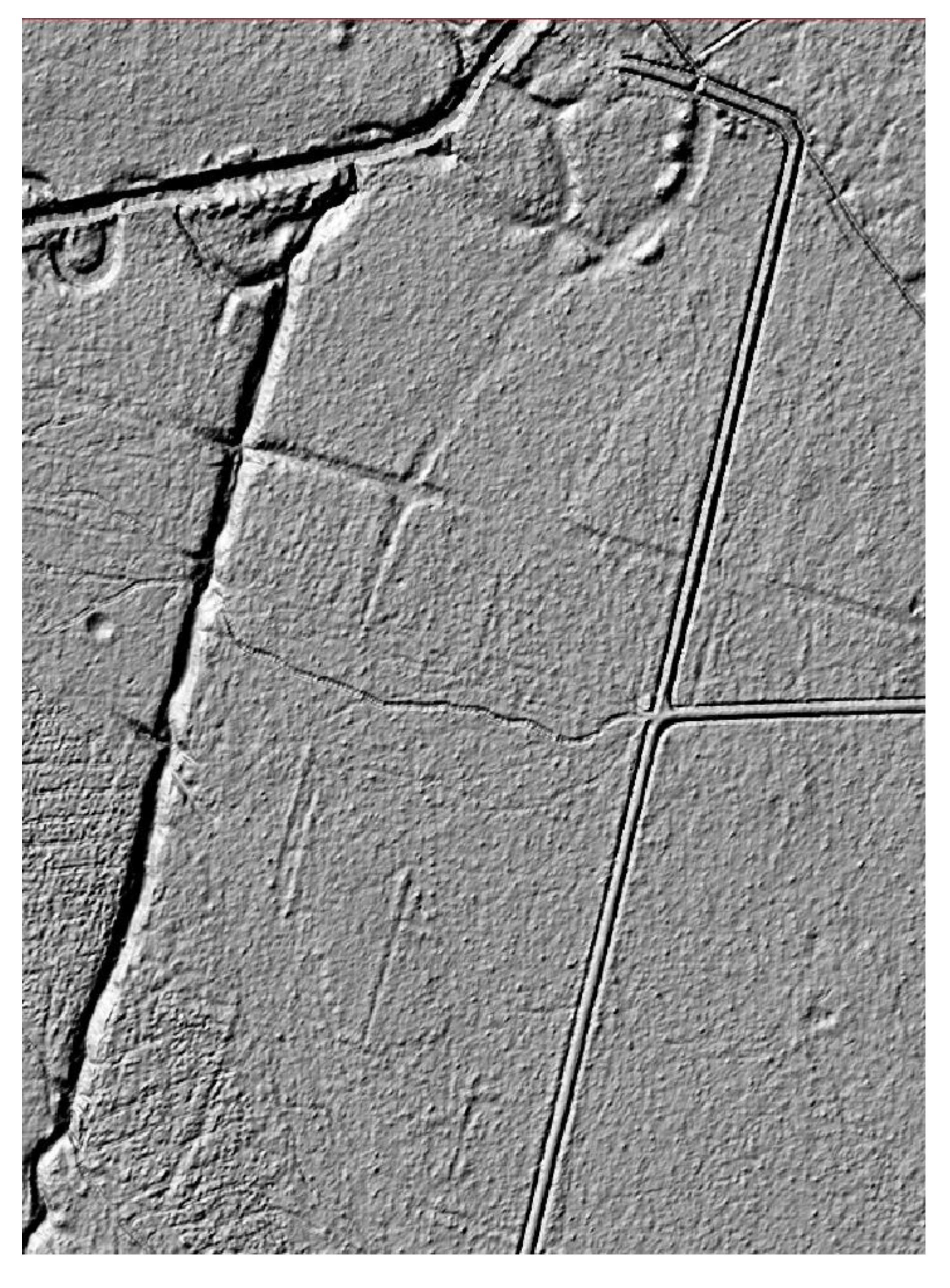
3.2.1. Main Grid
3.2.2. Internal Division
3.3. Roads
4. Discussion
5. Conclusions
Author Contributions
Funding
Data Availability Statement
Conflicts of Interest
References
- Campbell, B. Introduction, Text, Translation and Commentary. In The Writings of the Roman Land Surveyors, Journal of Roman Studies Monographs 9; Society for the Promotion of Roman Studies: London, UK, 2000. [Google Scholar]
- Campbell, B. Shaping the rural environment: Surveyors in ancient Rome. J. Rom. Stud. 1996, 86, 74–99. [Google Scholar] [CrossRef]
- Durman, A. O geostrateškom položaju Siscije. Opusc. Archaeol. 1992, 16, 117–131. [Google Scholar]
- Klemenc, J. Archeologische Karte von Jugoslawien, Blatt Zagreb; Akademie der Wissenschaften: Belgrade, Serbia, 1938. [Google Scholar]
- Koščević, R.; Makjanić, R. Antički tumuli kod Velike Gorice i nova opažanja o panonskoj radionici glazirane keramike. Pril. Instituta Arheol. Zagreb. 1986, 3/4, 25–70. Available online: https://hrcak.srce.hr/1074 (accessed on 2 June 2025).
- Gregl, Z. Noričko-panonski tumuli u Hrvatskoj. Izd. Hrvat. Arheol. Druš. 1990, 14, 101–109. [Google Scholar]
- Gregl, Z. Turopolje. Arheol. Pregl. 1990, 29, 250–252. [Google Scholar]
- Tustonjić, A.; Pavelić, J.; Farkaš-Topolnik, N.; Đuričić-Kuric, T. Šume unutar prostornog plana Zagrebačke županije. Šumar. List 1999, 9–10, 469–485. [Google Scholar]
- Župetić, V. Povijest nastanka i očuvanja Vrata od Krča u Turopoljskom lugu. God. Zašt. Spomen. Kult. Hrvat. 2021, 45, 89–103. Available online: https://hrcak.srce.hr/index.php/292055 (accessed on 2 June 2025).
- Gilman Romano, D. The orientation of towns and centuriations. In A Companion to the Archaeology of the Roman Republic, 1st ed.; Evans, J.D., Ed.; Wiley-Blackwell: New York, NY, USA, 2013; Chapter 16; pp. 253–267. [Google Scholar] [CrossRef]
- Dilke, O.A.W. The Roman Land Surveyors. In An Introduction to the Agrimensores; David and Charles: Devon, UK, 1971. [Google Scholar]
- Bulić, D. Rimska centurijacija Istre. Tabula 2012, 10, 50–74. [Google Scholar] [CrossRef]
- Bulić, D. Rimska Ruralna Arhitektura Istre U Kontekstu Ekonomske I Socijalne Povijesti. Ph.D. Thesis, Odjel za Arheologiju, Sveučilišta u Zadru, Zadar, Croatia, 2015. [Google Scholar]
- Bradford, J. A Technique for the Study of Centuriation. Antiquity 1947, XXI, 197–204. [Google Scholar] [CrossRef]
- Bradford, J. Ancient Landscapes. Studies in Field Archaeology; Bell: London, UK, 1957. [Google Scholar]
- Suić, M. Limitacija agera rimskih kolonija na istočnoj jadranskoj obali. Zb. Rad. Inst. Hist. Nauk. Zadru 1956, 1, 1–32. [Google Scholar]
- Chevallier, R. La centuriazione romana dell’Istria e della Dalmazia. Atti. Mem. Soc. Istriana Archeol. Stor. Patria 1961, 9, 11–24. [Google Scholar]
- Ilakovac, B. Land division of the Roman ager at Cissa on the island of Pag. Vjesn. Arheol. Muzeja Zagreb. 1997, 30–31, 81–82. Available online: https://hrcak.srce.hr/25333 (accessed on 6 August 2024).
- Kadi, M. Centurijacija Otoka Ugljana: Rimski Katastar = The Centuriation of the Island of Ugljan: The Roman Land Division; Zavod za Povijesne Znanosti: Zadar, Croatia, 2016. [Google Scholar]
- Kadi, M. Centurijacija otoka Ugljana. Kartogr. Geoinf. 2019, 18, 98–107. Available online: https://hrcak.srce.hr/222073 (accessed on 13 August 2024).
- Popović, S.; Bulić, D.; Matijašić, R.; Gerometta, K.; Boschian, G. Roman land division in Istria, Croatia: Historiography, LIDAR, structural survey and excavations. Mediterr. Archaeol. Archaeom. 2021, 21, 165–178. [Google Scholar] [CrossRef]
- Bernardini, F. Rediscovering the Lost Roman Landscape in the Southern Trieste Karst (North-Eastern Italy): Road Network, Land Divisions, Rural Buildings and New Hints on the Avesica Road Station. Remote Sens. 2023, 15, 1506. [Google Scholar] [CrossRef]
- Hoti, M. Sisak u Antičkim izvorima. Opusc. Archaeol. 1992, 16, 133–163. [Google Scholar]
- Kušan Špalj, D.; Nemeth-Ehrlich, D. Municipium Andautonia. In The Autonomous Towns of Noricum and Pannonia/Die autonomen Städte in Noricum und Pannonien, Pannonia I (Situla 41); Šašel Kos, M., Scherrer, P., Eds.; Narodni muzej Slovenije: Ljubljana, Slovenia, 2003; pp. 107–117. [Google Scholar]
- Kovacs, P. Territoria, pagi and vici in Pannonia. In Studia Epigraphica in Memoriam Géza Alföldy; Eck, W., Fehér, B., Kovács, P., Eds.; Dr. Rudolf Habelt GmbH: Bonn, Germany, 2013; pp. 131–153. [Google Scholar]
- Sokol, V. Najnovija arheološka istraživanja u Prigorju. Izd. Hrvat. Arheol. Druš. 1981, 6, 169–185. [Google Scholar]
- DGU LIDAR. Available online: https://dgu.gov.hr/UserDocsImages/dokumenti/Istaknute%20teme/Multisenzorno%20snimanje/LiDAR%20snimanje%20iz%20zraka.pdf (accessed on 23 July 2024).
- Kokalj, Ž.; Somrak, M. Why Not a Single Image? Combining Visualizations to Facilitate Fieldwork and On-Screen Mapping. Remote Sens. 2019, 11, 747. [Google Scholar] [CrossRef]
- Zakšek, K.; Oštir, K.; Kokalj, Ž. Sky-View Factor as a Relief Visualization Technique. Remote Sens. 2011, 3, 398–415. [Google Scholar] [CrossRef]
- Kokalj, Ž.; Čonč, K. QGIS Relief Visualisation Toolbox plugin: AARG Online workshop, 25 May 2023. 2023. Available online: https://www.researchgate.net/publication/371226392_QGIS_Relief_Visualisation_Toolbox_plugin_AARG_Online_workshop_25_May_2023 (accessed on 23 July 2024).
- Beuk, J.; Rončević, J.; Drvodelić, D. Turopoljski Lug. 2023. Available online: https://repozitorij.sumfak.unizg.hr/islandora/object/sumfak%3A3386/datastream/FILE0/view (accessed on 2 June 2025).
- Arcanum. Arcanum Maps [WWW Document]. Available online: https://maps.arcanum.com/en/ (accessed on 4 August 2024).
- Geoportal.dgu.hr. Available online: https://geoportal.dgu.hr/ (accessed on 20 May 2024).
- Nagy, L. Beiträge zur Herkunftsfrage der norischen und pannonischen Hügelgräber. Acta Archaeol. 2002, 53, 299–318. [Google Scholar] [CrossRef]
- Caravello, G.U.; Michieletto, P. Cultural Landscape: Trace Yesterday, Presence Today, Perspective Tomorrow For “Roman Centuriation” in Rural Venetian Territory. Hum. Ekol. Rev. 1999, 6, 45–50. Available online: http://www.jstor.org/stable/24707056 (accessed on 19 September 2024).
- Kremenić, T.; Varotto, M.; Ferrarese, F. Forgotten Ecological Corridors: A GIS Analysis of the Ditches and Hedges in the Roman Centuriation Northeast of Padua. Sustainability 2024, 16, 8962. [Google Scholar] [CrossRef]
- Dubravica, B. Turopoljsko Plemstvo Poslije Ukidanja Kmetstva; Narodno sveučilište Velika Gorica & Plemenita općina Turopoljska: Velika Gorica, Croatia, 1997. [Google Scholar]
- Kolar Dimitrijević, M. Kratak osvrt na povijest šuma Hrvatske i Slavonije od 1850. godine do Prvoga svjetskog rata. Ekon. Ekohist. 2008, 4, 71–93. [Google Scholar]
- Božić, A. Magna Silva Turopoljski Lug; Knjiga 1; Magna silva: Velika Gorica, Croatia, 2016. [Google Scholar]
- Katančić, M.P. Specimen Philologiae et Geographiae Pannoniorum in Quo de Origine Lingua et Literatura Croatorum, Simul de Sisciae, Andautonii, Nevioduni, Poetovionis Urbium in Pannonia Olim Celebrium et His Intriectarum via Militari Mansionum Situ Disseritur Auctore Math. Petro Katancsich in Archigymn; schol. human. professore p. o.; Typis Episcopalibus: Zagreb, Croatia, 1795. [Google Scholar]
- Knezović, I. Katančićev Andautonij: Vrhunac znanstvenog istraživanja arheologije i stare povijesti na zagrebačkom području u 18. st. Rad. Zavoda Hrvat. Povij. Filoz. Fak. Sveuč. Zagrebu 2008, 40, 11–47. Available online: https://hrcak.srce.hr/49036 (accessed on 13 August 2024).
- Koprivnjak, V. Sisak-Zagrebačka ulica. Hrvat. Arheol. God. 2014, 10, 278–280. [Google Scholar]
- Dizdar, M.; Tonc, A.; Ložnjak Dizdar, D. Zaštitna istraživanja nalazišta AN 6 Gornji Vukojevac na trasi auto-ceste Zagreb—Sisak, dionica Velika Gorica jug—Lekenik. Ann. Instituti Archaeol. 2011, VII, 61–64. Available online: https://hrcak.srce.hr/89817 (accessed on 13 August 2024).
- Bugar, A. Šepkovčica. Hrvat. Arheol. God. 2009, 5, 269–273. [Google Scholar]
- Vrbanović, S. Prilog proučavanju topografije Siscije. Izd. Hrvat. Arheol. Druš. 1981, 6, 187–199. [Google Scholar]
- Kadi, M. Centurijacija andautonijskog agera, Rimski katastar. Kartogr. Geoinf. 2021, 20, 77–91. Available online: https://hrcak.srce.hr/307190 (accessed on 15 August 2024).
- Groh, S. Novosti u urbanizmu municipija Andautonije-Ščitarjevo (Gornja Panonija, Hrvatska): Analiza i arheološko-povijesna interpretacija geofizičkih mjerenja iz 2012. godine. Vjesn. Arheol. Muz. Zagreb. 2014, 46, 89–113. Available online: https://hrcak.srce.hr/117906 (accessed on 14 August 2024).
- Lolić, T. Urbanism of Roman Siscia. Interpretation of Historical and Modern Maps, Drawings and Plans. In Archaeopress Roman Archaeology, 89; Archaeopress: Oxford, UK, 2022. [Google Scholar]
- Rodríguez-Antón, A.; Magli, G.; González-García, A.C. Between Land and Sky—A Study of the Orientation of Roman Centuriations in Italy. Sustainability 2023, 15, 3388. [Google Scholar] [CrossRef]
- Romano, D.G.; Tolba, O. Remote Sensing and GIS n the Study of Roman Centuriation in the Corinthia, Greece. Analecta Praehist. Leiden. 1996, 28, 457–463. [Google Scholar]
- Sparavigna, A.C. Roman Centuriation in Satellite Images. Philica 2015, 547. [Google Scholar] [CrossRef]
- Dell’Acqua, F.; Iannelli, G.C.; Lisini, G.; Ricardi, N.; Gorrini, M.E.; Mussi, C. A landscape archaeology application of “big heritage data”: Detecting traces of Roman centuriations in large-scale, old aerial photos. In Proceedings of the 2015 IEEE International Geoscience and Remote Sensing Symposium (IGARSS), Milan, Italy, 2 November 2015; pp. 3080–3082. [Google Scholar] [CrossRef]
- De Haas, T. Managing the marshes: An integrated study of the centuriated landscape of the Pontine plain. J. Archaeol. Sci. Rep. 2017, 15, 470–481. [Google Scholar] [CrossRef]
- Bernardini, F.; Vinci, G.; Forte, E.; Mocnik, A.; Višnjić, J.; Pipan, M. Integrating Airborne Laser Scanning and 3D Ground-Penetrating Radar for the Investigation of Protohistoric Structures in Croatian Istria. Appl. Sci. 2021, 11, 8166. [Google Scholar] [CrossRef]
- Latinčić, D.; Regan, K. Turopljske utvrde. Stud. Lexikogr. 2021, 15, 7–49. [Google Scholar] [CrossRef]
- Sevink, J.; de Haas, T.C.; Alessandri, L.; Bakels, C.C.; Mario, F.D. The Pontine Marshes: An integrated study of the origin, history, and future of a famous coastal wetland in Central Italy. Holocene 2023, 33, 1087–1106. [Google Scholar] [CrossRef]
- Doneus, M.; Briese, C.; Fera, M.; Janner, M. Archaeological prospection of forested areas using full-waveform airborne laser scanning. J. Archaeol. Sci. 2008, 35, 882–893. [Google Scholar] [CrossRef]
- Opitz, R.S.; Cowley, D.C. Interpreting Archaeological Topography: 3D Data, Visualisation and Observation; Oxbow Books: Oxford, UK, 2013. [Google Scholar] [CrossRef]
- Vinci, G., Vanzani, F., Fontana, A., Campana, S., Eds.; LiDAR applications in archaeology: A systematic review. Archaeol. Prospect. 2025, 32, 81–101. [Google Scholar] [CrossRef]
- Affek, A.N.; Wolski, J.; Latocha, A.; Zachwatowicz, M.; Wieczorek, M. The Use of LiDAR in Reconstructing the Pre-World War II Landscapes of Abandoned Mountain Villages in Southern Poland. Archaeol. Prospect. 2022, 29, 157–173. [Google Scholar] [CrossRef]
- Sobala, M. Detection of Past Landscape Elements in Marginal Mountain Areas—The Example of the Western Carpathians. Archaeol. Anthropol. Sci. 2023, 15, 48. Available online: https://link.springer.com/article/10.1007/s12520-023-01750-3 (accessed on 2 July 2024).
- Johnson, K.M.; Ouimet, W.B. An Observational and Theoretical Framework for Interpreting the Landscape Palimpsest through Airborne LiDAR. Appl. Geogr. 2018, 91, 32–44. [Google Scholar] [CrossRef]
- Abate, N.; Goffredo, R.; Dato, G.; Minervino Amodio, A.; Loperte, A.; Frisetti, A.; Ciccone, G.; Zaia, S.E.; Sileo, M.; Lasaponara, R.; et al. Adopting an Open-Source Processing Strategy for LiDAR Drone Data Analysis in Under-Canopy Archaeological Sites: A Case Study of Torre Castiglione (Apulia). Remote Sens. 2025, 17, 1134. [Google Scholar] [CrossRef]


Disclaimer/Publisher’s Note: The statements, opinions and data contained in all publications are solely those of the individual author(s) and contributor(s) and not of MDPI and/or the editor(s). MDPI and/or the editor(s) disclaim responsibility for any injury to people or property resulting from any ideas, methods, instructions or products referred to in the content. |
© 2025 by the authors. Licensee MDPI, Basel, Switzerland. This article is an open access article distributed under the terms and conditions of the Creative Commons Attribution (CC BY) license (https://creativecommons.org/licenses/by/4.0/).
Share and Cite
Kalafatić, H.; Šiljeg, B.; Šošić Klindžić, R. Fields in the Forest Roman Land Division Between Siscia and Andautonia Through LIDAR Data Analysis. Heritage 2025, 8, 234. https://doi.org/10.3390/heritage8060234
Kalafatić H, Šiljeg B, Šošić Klindžić R. Fields in the Forest Roman Land Division Between Siscia and Andautonia Through LIDAR Data Analysis. Heritage. 2025; 8(6):234. https://doi.org/10.3390/heritage8060234
Chicago/Turabian StyleKalafatić, Hrvoje, Bartul Šiljeg, and Rajna Šošić Klindžić. 2025. "Fields in the Forest Roman Land Division Between Siscia and Andautonia Through LIDAR Data Analysis" Heritage 8, no. 6: 234. https://doi.org/10.3390/heritage8060234
APA StyleKalafatić, H., Šiljeg, B., & Šošić Klindžić, R. (2025). Fields in the Forest Roman Land Division Between Siscia and Andautonia Through LIDAR Data Analysis. Heritage, 8(6), 234. https://doi.org/10.3390/heritage8060234