1. Introduction
Erasmus+ is the European Union programme (2014–2020 and 2021–2027;
https://erasmus-plus.ec.europa.eu/) (accessed on 1 March 2021) to support education, training, youth, and sport in Europe; it offers mobility and cooperation opportunities and funding for individuals and organisations in order to modernise education, training, and youth work across Europe. Within Erasmus+ 2014–2020, Key Action 2 of the Erasmus+ program is devoted to developing “strategic partnerships”, aimed at sharing best practice and fostering collaborative work.
The Global Geopark Network (GGN; founded in 2004; [
1]) is a network of territories designated as UNESCO Global Geoparks (UGGps) who are committed to working together, exchanging best practices, and joining in common projects to raise the quality of all their products and practices [
2,
3,
4]. The International Geoscience and Geoparks programme (IGGP) of UNESCO is intended to promote a global network of geoparks that safeguard and develop acknowledged geographical areas presenting significant geological features and also to support initiatives for the promotion of important geological sites, which is in line with sustainable development [
5,
6].
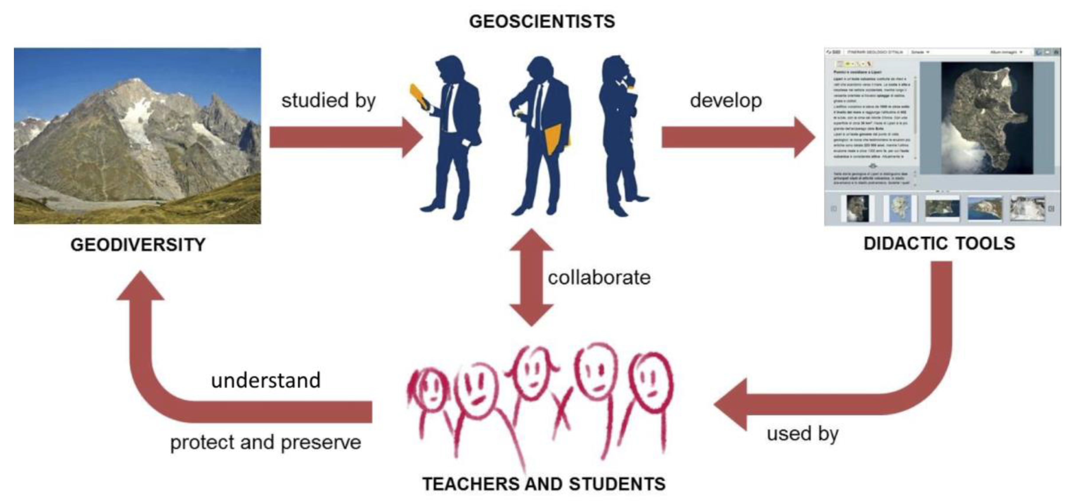
Since both the Erasmus+ and IGGP programs aim to develop models of best practices, with this review paper on international geoscience partnerships, we would like to demonstrate that a shared playground for common activities can be found in areas characterised by high geodiversity and rich geoheritage in order to (a) promote innovation for geoscience education and (b) introduce new skills and pedagogical approaches [
7]. In turn, these could improve strategic planning and help in delivering high-quality standards for territorial management within geoparks, thus integrating the preservation of geological heritage [
8,
9] into strategies for regional sustainable development [
10].
A common concern for all the UGGPs is the social and economic consequences and increased impacts on geodiversity by the present climate change. Their assessment is not only a technical issue to better manage the regional geoheritage [
11]; in order to enhance geoheritage recognition and protection within geopark areas, you also have to spread, either within students or the general public, the awareness on the role of geosystems [
12] and geodiversity [
13] in both controlling environmental dynamics and contributing to ecosystem services recognition and enhancement [
14,
15,
16]. This can lead to improvements in the understanding and response to the changes in climate and environment [
17,
18].
Based on this premise, two Erasmus+ strategic educational partnerships focusing on geoheritage, climate change, and geoparks have been developed since 2013 for exchanging groups of students between UGGps and high schools in different EU countries (Finland, Italy and France), with targeted educational objectives:
Developing basic and transversal skills using innovative methods;
Enhancing digital integration in learning, teaching, training, and youth work at various levels and strengthening quality through mobility and cross-border cooperation.
The overall aims of the international partnerships were synthetised in the titles of two related, consecutive Erasmus+ projects (“geoCLIMhome; Geoheritage and Climate Change Opening the Secrets of Home” from 2015 to 2018 and “geoCLIMHome-Pro; Geoheritage and Climate Change Highlighting Professional Perspective” from 2018 to 2021), namely: (1) to spread understanding of present climate change and historical climatic variation as multidimensional phenomena both in time and space, and (2) to recognise both the natural and the human-induced aspects of climate change, either by exploring the living environment or by improving formative experiences such as those offered by meeting with professionals within the geopark areas.
Following their main objectives, both of the projects utilised the distinctive geoheritage of the geopark areas for studying the climate change and understanding its effects on ecosystem services and cultural history and cultural aspects [
14].
The first project focused on the “secret” values of local knowledge on geoheritage [
19,
20] for better awareness on climate and environmental changes; it strengthened the students´ understanding of the geological and human history of their home region and their roots [
21].
Within the second project, the active and passive roles of humans toward the geomorphological environment [
22,
23] have been analysed, based on contents from national school curricula (Finland, Italy, France) and the United Nation´s sustainable development goals (SDGs). The educational activities have been addressed to enhance students’ awareness of social responsibility, in order to stimulate active citizenship and to discover new job opportunities accomplishing the local and global needs of sustainable development, future, and lifestyles [
9,
23].
2. Geoheritage, Climate Change, and Geoparks within International Partnerships for School Education
The “GEOclimHOME” projects enable teachers and students to focus on geological heritage and climate change in the international and special contexts of UNESCO Global Geoparks, which are devoted to global understanding and sustainability [
6]. Climate change as a complex phenomenon is difficult to understand for many students, even though it deeply affects their everyday life [
24,
25,
26]. When approaching climate change issues, it is important to recognise two main components: natural and human-induced climate change [
27]. Even if it is difficult to separate “a priori” these two components, it is crucial to investigate the role of humans behind the climate change and to understand the diversity of possible factors impacting the rates of climate and environmental changes [
22] (
https://climate.nasa.gov/effects/) (accessed on 28 November 2021). Educational programs including field activities using environmental exploration for the direct appraisal of climate-related effects on geodiversity [
28], and laboratory activities for modelling local climatic trends and extreme events [
29], can make easier the understanding of climate change and boost actions for adaptation and mitigation [
9,
30,
31].
We consider climate change as a natural and cultural phenomenon. Moreover, it is a global phenomenon that has local consequences. The awareness and the relevance of geological heritage allows evidence of past environmental changes to be highlighted and reflection over the possible future changes. Climate change is closely related to the human life and culture (Declaration of the right of the memory of the Earth; Digne, France, 2001) [
32].
Transnational exchanges and visits in different geological, geomorphological, and cultural environments deepen the fundamental understanding of climate change, both from a local and global perspective. These exchanges also enable the collection of scientifically relevant data as well as the implementation and practice of a wide range of learning and research methods [
33,
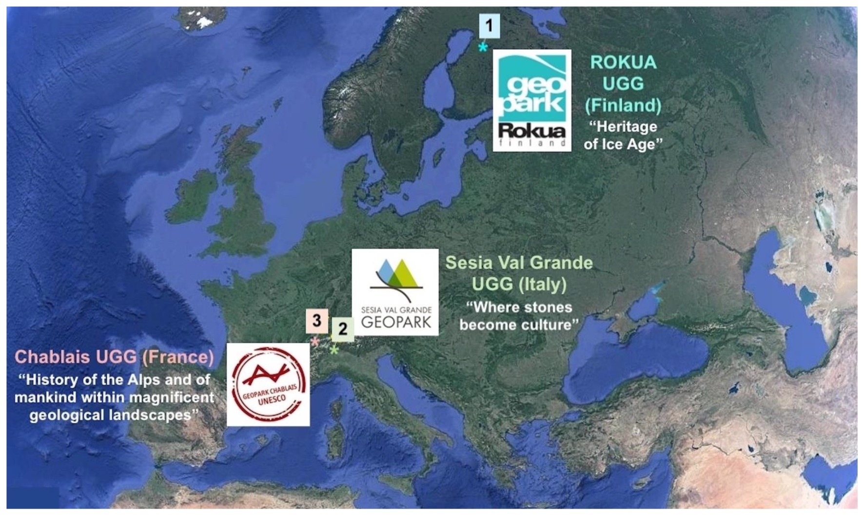
34]. Rokua, Sesia Val Grande, and Chablais UGGps (
Figure 1) offer very different but pedagogically outstanding environments for the study and exploration of climate change. The added value of these areas lies in their distinctive geological and cultural heritage [
24,
35]. This offers a natural laboratory for the investigation of long- and short-term climate change and also for a discussion around the effects of climate change on nature and culture. They represent ideal playgrounds for strategic EU partnerships devoted to cooperation for innovation and the exchange of best practice in school education within the ERASMUS+ framework.
2.1. Rokua UNESCO Global Geopark
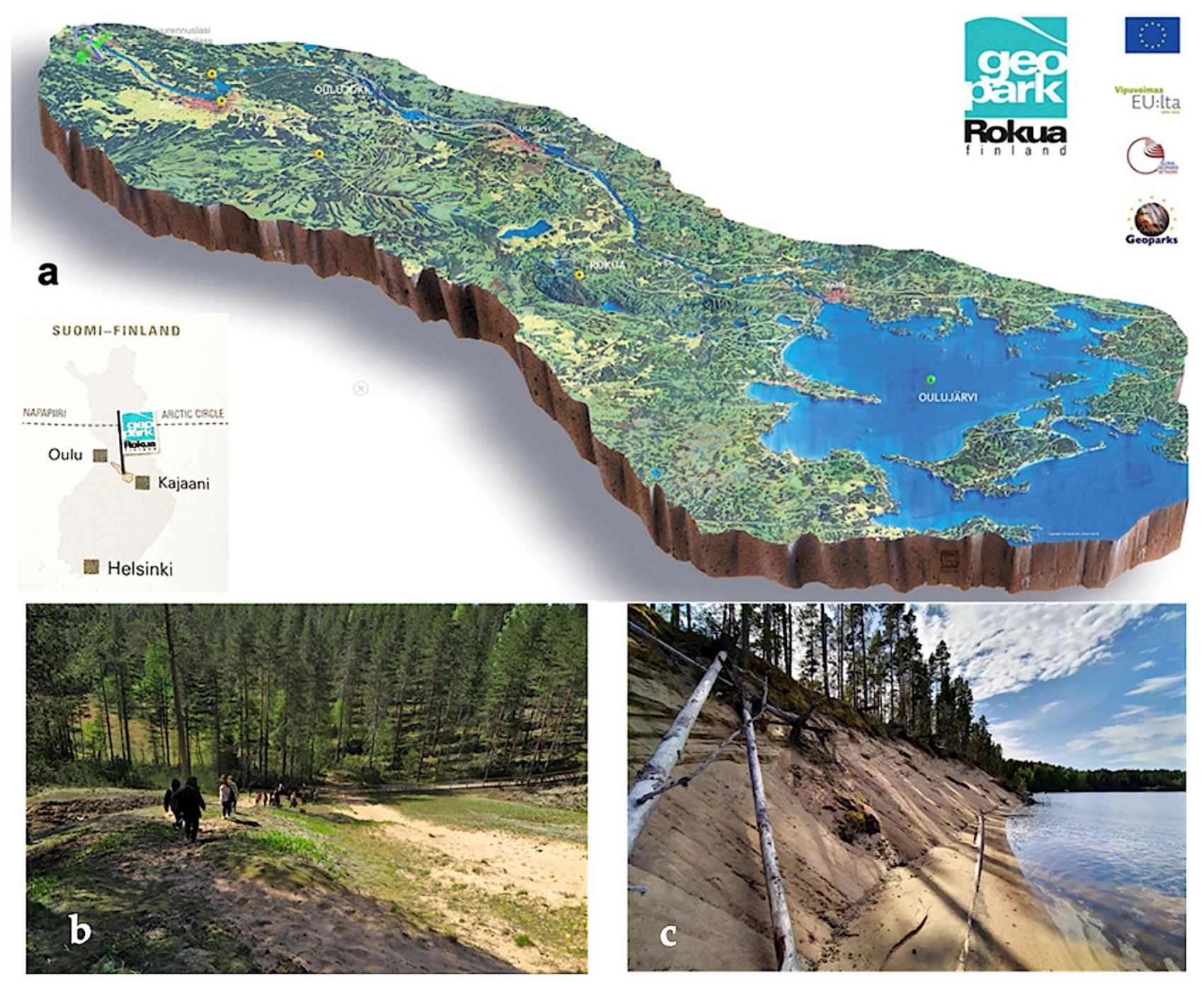
Rokua UNESCO Global Geopark is situated in Northern Finland, about 200 km south of the Arctic Circle between the cities of Oulu and Kajaani (
Figure 2). It has been a member of the European Geoparks Network (EGN) since 2010 and of the IGGP since November 2015. The geopark covers an area of about 1326 km
2 and includes three municipalities (Muhos, Utajärvi, and Vaala). It is bordered to the northwest by the Oulu urban area, Finland’s fifth largest city with around 200,000 inhabitants.
Rokua Geopark covers three landscape areas: the River Oulujoki Valley, the Rokua esker and dune area, and the Lake Oulujärvi district. Rokua Geopark’s geoheritage includes a number of impressive bedrock sites illustrating the long-term development stages of the Fennoscandian crystalline basement dating back even to the Archean era. Rokua Geopark´s main theme is “The Heritage of the Ice Age”; namely, the area offers a varied mosaic of thousands of glaciogenic, glaciofluvial, littoral, and aeolian landforms and deposits such as drumlins, hummocky moraines, terminal moraines, esker ridges and deltas, kettle holes, ancient shorelines, dunes, ravines, and bogs that trace the onset of the Pleistocene continental ice sheet and its melting stage. The most significant traces of the continental ice sheet can be found in the Rokua esker and dune area and on the Manamansalo Island in the Lake Oulujärvi district, where the glacial deposits overlay the Archean basement. The heritage also includes the postglacial land uplift and the concomitant landforms. In addition to the geological history, the geopark also introduces the evolution of life in ancient times and after the last Ice Age, and it tells the story of the prehistoric people who followed the retreating sea cost and inhabited the area during a time span of thousands of years. The most valuable findings and legends of the first inhabitants are located in the River Oulujoki Valley and on the shores of Lake Oulujärvi [
36].
Rokua Geopark’s special arctic character, contrasting long and cold winter and warm summer, combined with the vulnerable ecosystems hosted by the Ice-Age-related geomorphology, make this territory interesting for diverse interpretations of the relationships between geoheritage and climate change. Environmental conditions permit different field activities for the exploration, data collection, and even the direct appraisal of climate-related effects on geodiversity. This special character facilitates the educational activities of schools and other local institutions. [
37].
2.2. Sesia Val Grande UNESCO Global Geopark
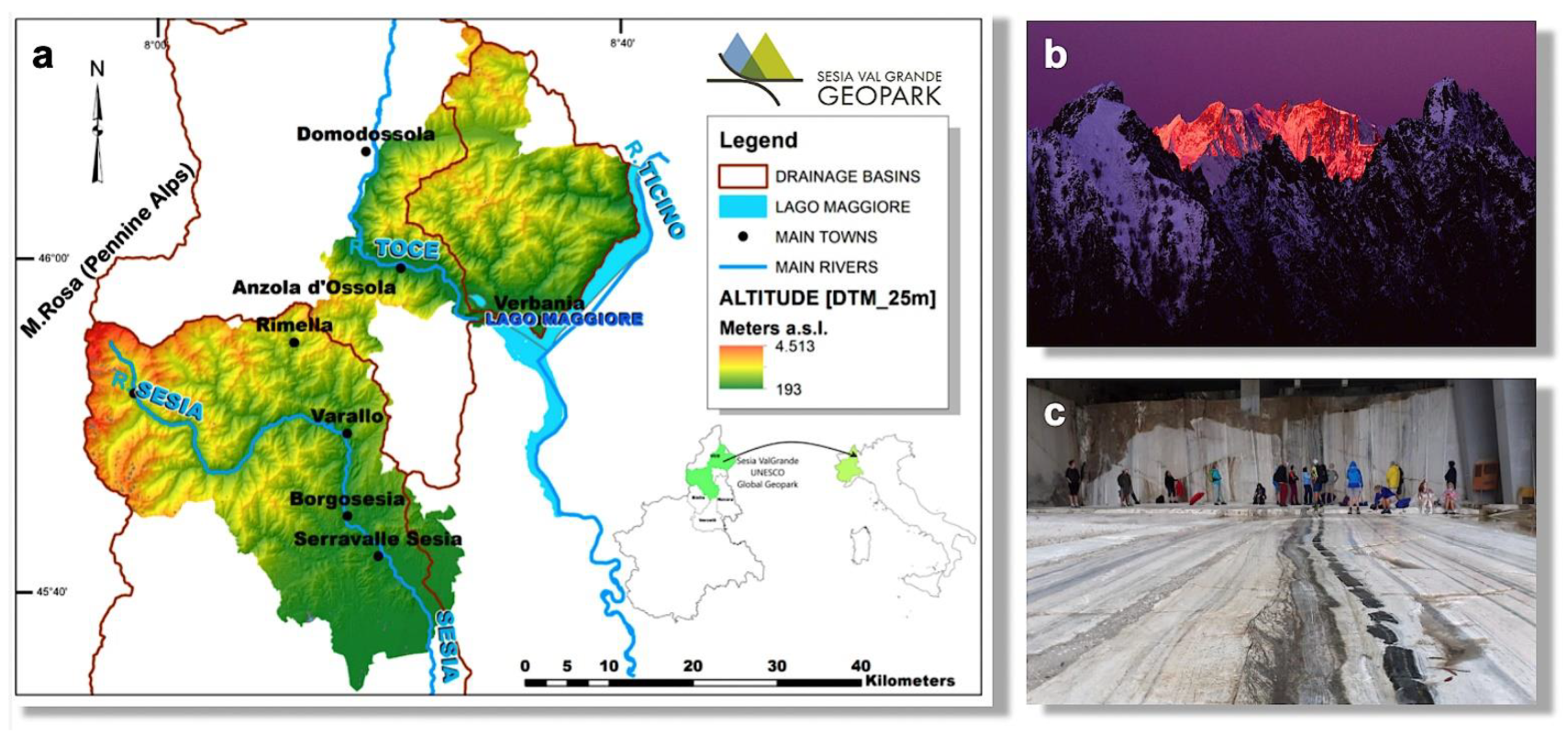
The Sesia-Val Grande UNESCO Global Geopark is located at the northeast of the Piemonte Region (NW Italy), from the Mount Rosa massif (Pennine Alps) to the Lake Maggiore, including the whole Val Grande National Park, the whole Sesia, and part of the Toce and Ticino drainage basins (
Figure 3). The Sesia Val Grande has been a member of the GGN since 2013 and of the IGGP since November 2015. It covers an area of about 2202 km
2 with a total population of 160,000 inhabitants.
The geodiversity of the Sesia-Val Grande UGGp includes a diversity of landforms, processes, and earth’s materials of the last 500 million years. The distinctive alpine geoheritage was recently analysed by researchers operating in the geopark for the proper implementation of conservation measures [
38]. As a whole, the geopark territory offers visitors the opportunity to observe the processes that formed the Alps and which have deformed the earth’s crust, including its deepest features: the Ivrea Verbano Zone is located here, one of the most spectacular sections of the earth’s crust [
39], which also includes a whole fossil supervolcano system, from the most superficial rocks of the caldera to a depth of 25 km [
40]. Since the Sesia Val Grande UGGp extends from the Mount Rosa massif to the Po Plain, it also shows the record of past climate changes and of the glacial, periglacial, water- and gravity-related processes that continuously shape the landscape [
41].
The scientific relevance of the Sesia Val Grande geoheritage highlights the role of its geological matrix in influencing human culture. The geopark’s motto, “Where stone becomes culture”, is a recognition of the importance of the abiotic ecosystem services offered by different lithologies, which foster not only the local stone cultural landscape but also great architectural achievements such as the Milan Cathedral (made of Candoglia Marbles). Moreover, the awareness of climate change is a characteristic of the local culture of the Walser people, whose migration from Valais, Switzerland happened in the 14th century: since then, they have preserved the Alemanic language, culture, and architecture, but also, they adapted to new environmental conditions during the Little Ice Age (1450–1850) and had a proactive behaviour towards natural hazards and resources of the mountain area. This historical perspective is a strong point for developing environmental educational activities; it helps to raise the awareness of the importance of nature conservation and territorial management within local communities and schools.
2.3. Chablais UNESCO Global Geopark
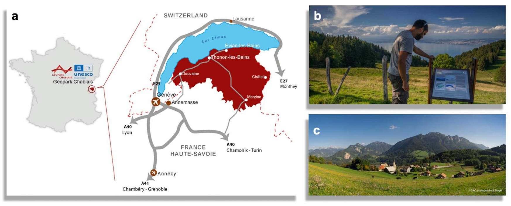
The Chablais UGGp is situated in eastern France between Lake Geneva and Mont Blanc. It has been a member of the GGN since 2012 and of the IGGP since November 2015. The geopark covers an area of 935 km
2 with rolling agricultural land to the north and contrasting alpine summits to the south. Its population is slightly over 150,000 inhabitants concentrated along the densely inhabited southern shores of Lake Geneva, whose principal agglomerations are Thonon-les-Bains and Evian-les-Bains (
Figure 4).
Chablais UGGp encompasses more than 250 million years of geological history from the formation of the Alps to the recent glacial events that have carved out the landscape. The riches of this geological history are visible, notably through a large number of lakes and a wealth of renowned mineral waters (Evian, Thonon). The quality of its geological record and the ease of its interpretation render the area of international significance for the understanding of the Alpine Orogeny and the development of tectonic thrust theories.
Education and public awareness raising is a key objective for the Chablais UNESCO Global Geopark. By following the transversal nature of UNESCO Global Geoparks that includes the earth sciences, climate change, natural hazards, human geography, history, art, literature, and music, the Chablais’ Geopark school programme offers field trips and laboratory activities which are aligned with the national curriculum. Sustainable development of the territory is promoted through geotourism by local guides and the tourist offices network. The importance of the geoheritage of the Chablais and its influence over the cultural, social, and economic history of the area is central to its many educational activities.
4. Pedagogical Approach and Methods
During the years 2015–2021, two Erasmus+ projects have been realised: GEOclimHOME (2015–2018), with the involvement of Italian and Finnish students, and GEOclimHOME-PRO (2018–2021), with the involvement of Italian, Finnish, and French students at the age of 16–18. The common pedagogical approach is presented below, highlighting the different methodological solutions for approaching two consecutive steps:
- (1)
Geoheritage and climate change opening the secrets of home;
- (2)
Geoheritage and climate change for highlighting the professional perspective.
The first step focused on the retrospective analyses of elements of the earth’s and human history related to climate and environmental changes: from long-term natural archives (rock, soil, ice, etc.) to memories of our recent past (paintings, photographs, but also tools, legend, and stories). The second step focused on a diverse professional figures within geoparks, providing relevant examples of possible careers for enhancing geoheritage and improving adaptation to climate change and territorial management within geoparks’ territories.
In both GEOclimHOME projects, thanks to the involvement of the schools, the UGGps, and the research institutions, different subjects have been integrated: natural sciences (physical geography, geology, biology, physics, chemistry), social sciences (history, archaeology), culture (cultural geography, history), informatics, international culture, and foreign languages (English). The mentioned disciplines are part of the school curriculum in all the countries involved; the greatest number of subjects are part of the Natural Sciences sector.
Within these subjects, an Inquiry-Based Scientific Education (IBSE) approach, or, in the other words, an exploratory teaching method, was applied, which is an inductive approach to science teaching, putting direct experience at its centre [
46,
47]. The activities aim at actively involving students in the identification of relevant proofs of scientific phenomena and to examine them with critical and logical thinking. Students learn not only how to conduct scientific experiments but also how scientists process information to develop knowledge. While communicating with each other, the students also learn group working skills. In this case, the students themselves confront the study objectives (biological phenomenon, climate variables, geological features of the land, metering tools, etc.), ask themselves relevant questions, formulate hypotheses, verify them through experiments, and discuss the results: they acquire direct experience of the phenomena that they are studying and reach their conclusions autonomously. One of the main benefits is that this does not involve complicated experiments with expensive or special tools. However, considerable preparation time is required by the exchange partners to identify and scope suitable themes and experimentation sites. This also requires careful preparation and pedantic monitoring by the supervisors to avoid any incorrect learning.
Both GEOclimHOME and GEOclimHOME-PRO projects are not a standard “academic” experiences: they both target scientific work on real situations by maintaining a learning approach based on the building of knowledge and abilities but also by achieving skill goals (
Figure 5).
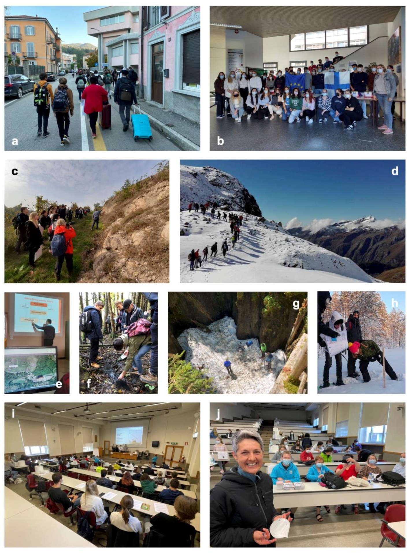
The original project plan proposed short international exchanges (1 week) between students (max 20; aged 16–18) from 2 “live” participant schools at a time and 1 school through remote participation. Due to the COVID-19 pandemic conditions, changes in this program occurred, and a virtual exchange was introduced as a solution during lockdown conditions.
During regular exchanges, costs were reduced because students were hosted by local families. In any case, the improvement of English as a foreign language was considered as a tool for achieving new skills in a different culture. The preliminary study of geoheritage with teachers, the performance of scientific observations, and data collection guided by researchers and the participation to cultural activities allows a deeper perception of the relevance of the climate change for natural and human systems.
A typical weekly schedule of the short exchanges includes two days for travelling and five days for working. The first day is devoted to introductions, discovery of the area of the hosting UNESCO Global Geopark, and the main scientific activities of the week. Then, three days of field activities are performed. The last working day is finally dedicated by the students, in groups, to summarise the data collected during the previous days in different thematic presentations. Evaluations are also performed. The last evening is conceived as a final event during which the students present to their families, friends, teachers, and local community, the results of their studies (
Table 2 and
Figure 6).
Innovative educational activities are proposed in the UGGps. Peer learning is promoted: the local students act as guides for their foreign correspondents and critical thinking is stimulated through a problem-posing–problem-solving approach. Information and Communication Technologies (ICT) are used for gathering and processing data on the field [
48,
49,
50].
One of the most important contributions to these experiences is the scientific lectures from local experts, such as university professors, experts, entrepreneurs, and researchers.
Field activities are executed within mixed working groups, which are composed both by Finnish and Italian students, following the methodology called peer learning [
51]. Host country teachers and researchers developed the working plans [
52]. The students, after observing the environment, with the field guides and the group coordinators asking leading questions, formulate hypotheses and collect relevant data. The group coordinators are host country students that act as peer educators to promote the local features to the foreign correspondents. For data collection, technologies such as PDF Maps are used, allowing to record the followed pathway, to highlight the most significant points, and to download the track with Google EARTH. In the end, each group presents their outcomes, thereby also teaching the other students at the same time. Finally, the supervisors conclude with summaries.
In addition to the international meetings, the students are prepared for the exchange by their teachers and the key people (researchers, technical boards, and geopark managers) involved in the project. Some meetings at school present the local geopark area and its main geological and cultural features. Students prepare materials for the activities with their foreign correspondents (e.g., those used in the field guides). At the end of the short exchange’s discussions, they are encouraged in the classroom. This evaluation phase is an important part of the project to achieve results.
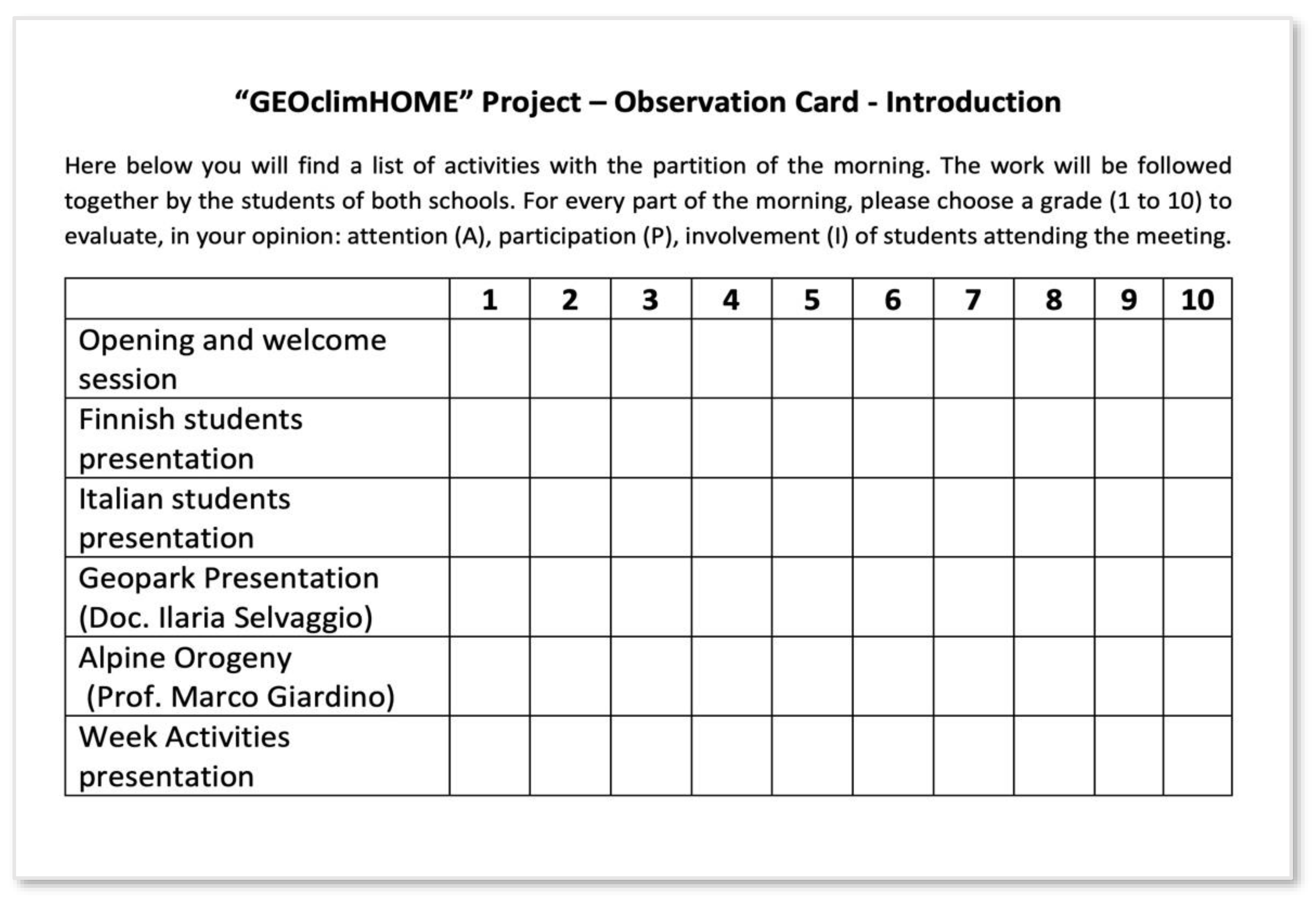
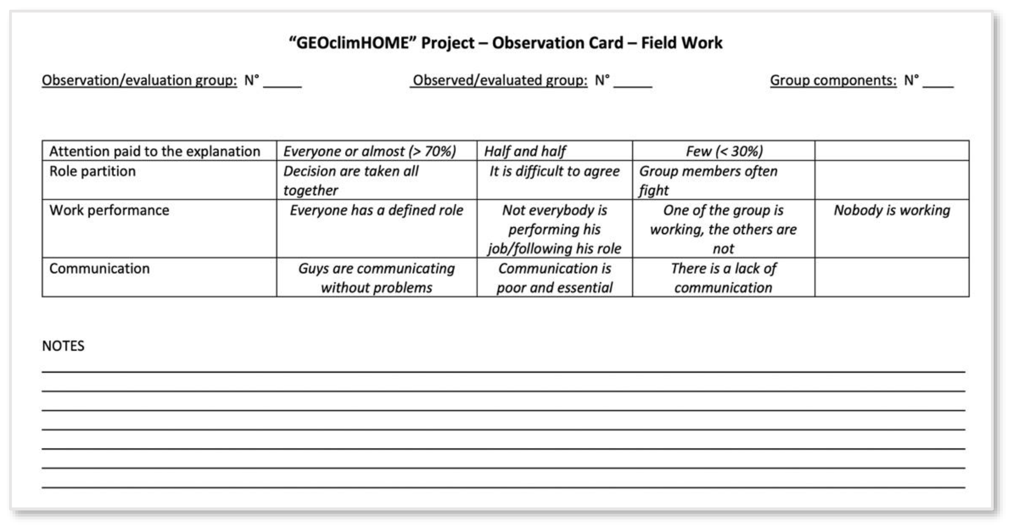
In order to evaluate and validate the learning outcomes, the following activities are performed:
- -
Preparation of observation cards to monitor and evaluate the interest, participation, and involvement of students attending the meeting (
Figure 7);
- -
Preparation of observation cards to evaluate role sharing, work performance, and communication in the group during the site working (
Figure 8);
- -
Evaluation and self-evaluation cards of competence acquired by the students;
- -
Feedback and conversation with the students and learning diaries.
In Italy, I.I.S. Cobianchi shares the methods and the results with the CompetensiISS network (established by the Italian Ministry of Education, MIUR) which shares virtuous teaching experiences and good practices for assessing students’ skills.
The last phase of shared activities with students consists of the analysis of collected data, including a discussion of the possible interpretation, in order to generate shared conclusions that are then presented to the community.
At the end of each exchange week, a final workshop is organised: the students coordinate working tables, where pupils from other classes or local schools participate. Students present their field experiences and conclusions with a peer-education activity. A final conference closes the experience.
As a result of updated topics (UN Agenda 2030 SDGs) and the enlarged partnership of the second project (GEOclimHOME-PRO, with a third school from Chablais Geopark, France), during each exchange week, a different school works remotely on its own territory on the same UN SDG topics as the two schools performing the in-person exchange. The activities, both in the field and in the classroom, follow the same modes and methodologies, with the support of experts and researchers from different universities. The “remote-working” partners participate in online meetings with the other students in order to compare the experiences and share the conclusions.
5. Activities and Evaluation Results
5.1. “GEOclimHOME”: “Geoheritage and Climate Change Discovering the Secrets of Home”
Since the school year 2013/14 to 2017/18, within the preparatory exchange and the first GEOclimHOME ERASMUS+ project, 149 secondary school students participated in the short exchanges (
Table 3). During the exchange, students were always accompanied by a team of project partners: their teachers (usually science and language teachers, but also teachers specialised in human sciences, such as history and philosophy), university researchers, and a representative from the UGGp staff.
According to the first main goal of the project, learning activities were addressed to understand climate change as a multidimensional phenomenon and to recognise both the natural and the human-induced aspects of climate change. The specific geoheritage of the geopark areas offered key elements for studying long-term and short-term aspects of climate change:
The long-term conditioning factors posed by the Last Glacial Maximum (20–18 ka) to the geomorphological landscape of the Rokua Geopark around the Rokua esker field and Lake Oulujärvi and along the River Oulujoki;
The rapid modifications of alpine glacial and periglacial environments of Sesia Val Grande during and after the Little Ice Age (1450–1850 CE), which caused the retreat of alpine glacier fronts and mountain slope instabilities.
The project also revealed the students the local “secret”—the unique natural and cultural heritage—thereby strengthening their identity with local culture and economy.
The changes in ice caps (properties, ice cover time) due to climate change have significant effects on Finnish lake ecosystems. The frozen lakes have also important cultural meanings in Finland: for example, the fishermen are fully dependent on the ice caps. Changes in the properties of the ice caps and can lead to cultural effects as well, and by interviewing fishermen, the students heard some practical experiences of this. Results benefited the students also in term of geodiversity appraisal and geoscience knowledge, by:
Learning of research methods (i.e., dendrochronological methods, species identification methods, soil profile measurement, climate data analysis, digital modelling, GIS-based field exercise methods, peat analysis and mire drilling, archaeological methods, georesources exploitation, glaciers retreat study).
Direct exploration of: “bedrock geology” (plate tectonics and Alpine orogenesis, and their geological time markers), geomorphological landscapes, and relationships between, rocks, georesources, and local culture.
By analysing the results of single field and laboratory activities as well as of final reports of exchange weeks within the first step of the GEOclmHOME project (
https://geoclimhomeblog.wordpress.com/geoclimhome-2015-2018/, accessed on 15 April 2021), the exchange program allowed students not only to be in touch with a new territory and culture but also to deepen their appreciation and develop a fresh perspective for their own territory and culture. A selection of the results is associated to this paper as
Supplementary Files S1 and S2, including data and images of the research activities. Contents and discussion of final presentations also revealed to teachers an increased student’s understanding of the values of geoheritage and local culture as well as an awareness of the emotional importance to the local people. These events turned out as special occasions for appraisal of the opportunities and the limits of the environment in human life.
5.2. “GEOclinHOME-PRO”: Geoheritage and Climate Change for Highlighting the Professional Perspective
Following the first successful GEOclimHOME project, the second GEOclimHOME-PRO partnership maintained its focus on climate change and related topics such as developing a knowledge of the driving processes, understanding of consequences within natural and human environments, and possible adaptation measures to increase the resilience of our society. Within this framework, the project capitalised on the contents of national school curricula and the international sustainable development goals (SDGs of UN Agenda 2030) to boost the appreciation of professional careers by means of cooperation between teachers, researchers, administrative persons, and stakeholders. The cooperation with Chablais UGGp broadened and deepened the thematic framework of the project and improved the quality of education. Eight objectives within the 17 SDGs have been selected for addressing specific field and laboratory activities of the short-term exchanges in the second project (see also
Table 4):
Quality education (UN-SDG 4);
Clean water (UN-SDG 6);
Clean and affordable energy (UN-SDG 7);
Inclusive and sustainable growth (UN-SDG 8);
Sustainable communities (UN-SDG 11);
Climate action (UN-SDG 13);
Life on land (UN-SDG 15);
Partnership for the goals and (UN-SDG 17).
Natural and cultural heritage of the Rokua, Sesia Val Grande, and Chablais UGGps offered targeted perspectives for the new activities focused on sustainable development (
Table 4). Climate change effects were analysed both in terms of impacts/risks (i.e., floods, avalanches, loss of bio/geodiversity, invasion of new species) and resources/opportunities (i.e., water supply, hydropower and green energy production, forestry, and tourism). To understand better the nature and consequences of the ongoing processes, activities were addressed to understand the past as well, and that is why the project also included the historical aspect (signs of former climate variation in bedrock, soils, ice, flora and fauna, as well as in human culture). A selection of the results is associated to this paper as
Supplementary Material Files S3 and S4; (see final notes of the paper), including data and images of the research activities.
To structure the learning content of the educational activities within the framework of the SDG topics, each GEOclimHOME-Pro exchange week (2018–2021) focused on specific environmental, territorial, and cultural characteristics of the geoparks.
Table 4 offers an overview of the dates, locations, and participants (host and guests, on-site or remote participation) of the exchange weeks. It further summarises the key questions posed in relation to the objectives of the selected SDGs and a description of the educational content that was designed to increase student insight into the different professions found within sustainable geopark territories.
The synthesis presented in
Table 4 of the GEOclimHOME-Pro exchange weeks is completed by the description of the specific methods and activities employed. It provides an overview of the field and laboratory activities that were performed in the geopark territories. These exercises allowed students to appraise the active and passive roles of humans towards the climate and environmental change. Activities included visits to geodiversity sites, infrastructure, museums, and other locations relevant to either the environmental, cultural, or economic aspects of each Geopark. The programme was designed to address global issues and local needs and also to deliver educational content on geoheritage and climate change, social responsibility and active citizenship. In-person and online meetings with professionals and researchers were organised to allow students to discover initiatives that deliver sustainable development in geopark territories.
5.3. Example of an Exchange Week: The Sustainable Community (SDG 11) of Chablais UGGp
The first GEOclimHOME-PRO exchange week was performed in France at Chablais UGGp in October 2018 with the direct participation of French and Finnish students; the Italian students joined remotely.
After a general introduction to the Sustainable Development Goals of UN Agenda 2030 and the specific contents of SDG 11, a key question was posed to all the participants of the GEOclimHOME-PRO project:
- -
How is the geopark’s community sustainable?
Field and laboratory activities, expert interviews, presentations, and open discussions were organised through the week to answer the key question. Different themes and learning objectives were approached according to analyses of the specific character of the Chablais UGGp, and comparisons were made with the environments, territories, and communities of the other partner geoparks.
Field activities first introduced the notion of continued environmental change influencing the geopark community by analysing geological and climate markers within the Thonon les Bains fluvio-glacial terraced landscape. By observing the role of terraces in the filtration and channelling of the water, students were able to understand the importance of drinking water resources at Blaves spring (
Figure 6f).
Thereafter, by visiting a farm and observing the sustainable land farming activities and interaction with water resources and land management, the theme of analyses of water cycle and restoring of water resources were approached, including contribution by urban design measures (green roofs, rainwater harvesting, daylighting of riverbeds, for sustainable urban drainage). Visit to the Thonon water purification station and meeting with the professionals of the water service allowed discussion about communities and their dynamics (decision making, governance, planning, conflict resolution, healthy and inclusive communities, ecovillages, and transition towns), including the professional perspective toward environmental issues.
Analysis of geodiversity and geoheritage of the Chablais UGGp also allowed students to understand past climates and landscapes and how they influence human activity today. In addition, the work demonstrated how we can use paleoenvironmental knowledge to prepare for the future. The visit to Reyvroz landslip, the presentation of geological history of the site, and a field exercise on monitoring methods and risk analysis allowed approaching the themes of sustainable resilient building, spatial planning, disaster preparedness, and community resilience. The visit to the Vailly geosite completed the knowledge on geology of the last ice age and the role of glacio-lacustrine deposits from an ancient ice dammed lake to control the present-day hydrogeological properties; the adaptation of this geosite for renewable energy production through a micro hydroelectric plant was finally explored.
The theme of historic sustainable communities and the possible suggestion for better water resources management and deeper climate change awareness was approached during the Bellevaux field trip. The ascent and the presentation of the Nifflon high summer farm and the traditional way of life contextualised different individual and collective wants and needs according to gender, age, income, and ability, and the related sustainable food production and consumption in a mountain community.
Conclusions on the role of sustainable communities within geopark territories and possible outcomes have been drawn based on the presentations from students to summarise work modules undertaken during the week. Discussion of the results of field investigation was enriched by the remote contributions from the Italian team of the Sesia Val Grande Geopark. They presented results of interviews to inhabitants of the Sesia and Anzasca Valleys (Monte Rosa massif), illustrating the role of the Walser population as a sustainable community through history.
5.4. Example of Field Activities: Cryosphere and Microclimate Surveys at Rokua Geopark
During the field trips to the Rokua esker and dune area in winter 2019 and to Manamansalo Island in winter 2021, students measured snow cover, lake ice cover, and microclimate.
For the snow cover, snow depth and snow water equivalent were measured, both affecting the insulation efficiency of snow. The measurements were carried out in selected locations using the official measurement method at a smaller scale. The aim was to practice the method and gain data for later analysis, not to produce official weather data, and therefore, the applied method was justifiable. The snow cover depth was measured with a stick, which was pushed through the snow until it reached the ground surface. This was repeated in a few sites located in a line crossing different environments, as classified by their land use. The snow water equivalent was measured by taking a sample of snow cover from the surface to ground by using a pipe with a known diameter. The sample was weighted, and the load in kilograms per square meter was calculated, as well as the amount of water in millimetres per square meter.
For lake ice cover, the total thickness as well as thicknesses of porous ice and bright ice layers were measured. At the same time, students practiced the identification of the different layers and studied their properties and genesis. The measurement was carried out by drilling a hole in the ice cover and measuring the layers with a special stick with an angle iron in the head or by sawing a cross-section of ice and identifying the layers and measuring their thickness. The measurement was repeated in few sites located in a line from shoreline to deeper water.
To understand the microclimate, measurements were made of the temperature under snow cover at ground level and at about one meter above the snow surface. The ground-level temperature was measured using an indicator at ground level and remote display attached to a stick pointing above the snow cover.
The snow cover and microclimate surveys were based on the assumption that snow, as a mixture of ice crystals and air, serves as an insulator for ground and living organisms beneath the snow cover protecting them against frost. Data from the Finnish Meteorological Institute shows that snow depth and snow-covered time period during the winter season are shrinking in Finland. The aim was to study the complexity of these variants, as well as the measurement of these variants to better understand the climatic mechanisms, the mechanisms that change how snow cover affects living nature and soil, and to experience how difficult it is to gather reliable data for further analyses.
The results obtained by the students clearly show how factors varied between different kinds of locations, and this gave opportunity to discuss the mechanisms in more detail. For example, snow cover might be thinner in open areas due to eolian transport and snow packing by the wind; it was also recognised that there was a lower insulation effect than on sites with thicker snow cover. This gives an indication that both the greater density and thinner cover, possible results of climate change, decrease the insulation effect. This might lead in the future to increased damage to living organisms. In turn, greater snow water equivalent due to increased (wet) precipitation during the snow cover period might lead to damage to buildings and trees. Changes in snow water equivalent and in snow-cover time period also led to a decreased predictability of waterflow within the watershed area. This could lead to problems in regulated water systems also to people living next to the waterbodies.
Ice cover measurements provided information around the mechanisms affecting the winter ice cover on the lakes. The results of the measurements indicated that water flow (velocity) critically affects the ice thickness. However, by interviewing the professionals, we also heard that the bright ice requires cold temperatures in early winter before snow cover forms; this is ice crystallised directly from the lake. In turn, porous ice forms from a mixture of water and snow on the surface of the lake ice. Due to air bubbles, porous ice has a lower density and therefore melts faster in the spring, shortening the ice cover time period. Increased precipitation and warmer temperatures in early winter are a probable consequence of climate change. Together, these lead to more favourable conditions for porous than bright ice, later freezing of the lake, and earlier melting of ice caps. Evidence for this process is seen in a long data series gathered for Lake Oulujärvi.
The changes in ice cover have significant effects on the lake ecosystem. In addition, frozen lakes also have an important cultural meaning in Finland, and, for example, the fishermen are fully dependent on ice cover. Changes in the properties of the ice cover and in the length of the ice cover time period can lead to cultural effects, and by interviewing fishermen, the students heard some practical experiences of this.
The ice cover studies can also be scaled to a more global level. The same physical mechanisms are affecting the sea ice on the Arctic Ocean and the Northern Atlantic Ocean. By understanding the local phenomena related to ice caps, it is also easier to understand the processes in a wider scale and in turn, when studying the global processes, it is also easier to recognise them in the local level.
5.5. Example of Public Recognition of the GEOclimHOME Partnership: A Resilient Pandemic Solution for UNESCO Designations
Results of the GEOclimHOME-PRO project were recognised at the international level for their good practice in resilience in UNESCO Global Geoparks during the pandemics. An initiative by the UNESCO Regional Bureau for Science and Culture in Europe (Venice), ‘’Talking about...: PAndemic and REsili-ence’’, investigated COVID-19 impact on the territories, institutional organisations, and economic activities within UNESCO designations, to understand what resilient pandemic solutions were adopted. The GEOclimHOME-PRO representative was invited to contribute to a public debate and to share data and outcomes from our project in a knowledge web platform and an exchange meeting online (
https://events.unesco.org/event?id=3406017155&lang=1033) (accessed on 15 April 2021), giving highlights to experiences from a diversity of UNESCO sites. This initiative was primarily aimed at site coordinators and local stakeholders but was open to anyone interested in the topic. After a first phase of investigation, which involved mainly site managers and the main stakeholders, the GEOclimHOME-PRO project was presented on 15 April 2021 during a webinar named “Talking about school and education”. The topic was “Erasmus at the time of the pandemic.” The meeting, dedicated to schools and educational and training activities, presented the experiences of Man and Biosphere Reserve and UNESCO Global Geoparks.
The GEOclimHOME experience was successfully shared to highlight the creative solutions of resilience identified in response to the current pandemic. Even the weaknesses of the GEOclimHOME project were discussed, along with their contribution to strengthening collaboration among UNESCO sites and their stakeholders. Moreover, the project inspired the identification of solutions that contribute to the achievement of the UN Sustainable Development Goals, strengthening the potential of UNESCO sites as sustainability laboratories and facilitating the dissemination of their best practice.
6. Discussion of Projects’ Outcomes and Conclusions
In order to fulfil the project’s targets, GEOclimHOME activities have been addressed to raise awareness and to develop skills on relevant topics for the natural, cultural, and socio-economical contexts of the UGGp areas. A selection of GEOclimHOME activities has been presented in a conceptual framework based on an Inquiry-Based Scientific Education (IBSE) approach. The inductive approach to science teaching places direct experience at its heart.
Activities offered insights into natural and cultural sites or events that could be explored and identified to fulfil the above-mentioned project topics. Results could be interpreted as examples of past or present, active or passive roles of man with respect to the environment.
Several lectures and workshops have been organised on the special values of the UGGp areas. Local schools agreed to use the UGGp territory as a basis for their educational programmes and to communicate about the work of UNESCO Global Geoparks and their objectives to the pupils. Analyses of preliminary and final questionnaires from both first and second projects revealed good approval from students. Particularly, the evaluation and validation process evidenced some positive learning outcomes and ability from GEOclimHOME activities:
Enhanced knowledge on present and past changes in climate and the fragile mountain and forest environments of the project areas;
The opportunity to experiment with new educational methods for the development of innovative curricula and training courses structured around the geoparks’ promotion and management;
Improved digital tools and ICT skills and the possibility to test new technologies both for the appraisal of climate and environmental changes and for enhanced performance of educational programs.
In addition to the reinforcing environmental and historical knowledge, analyses of preliminary and final questionnaires from both first and second ERASMUS+ projects revealed improved student language, social, and digital skills because of meetings and practical activities. Thanks to the peer learning approach, the following skills were developed:
To be able to work in a group;
To respect the roles and the different functions of the partners;
To accept the others and their diversity;
To respect the timing of the tasks received;
To be able to communicate clearly and fluently in a foreign language;
To be able to cope with problems and find solutions (problem solving);
To be able to decide independently; and
To be able to have good relationships with the partners.
GEOclimHOME results also benefited the project organisation, the participating schools, and the UGGp territories:
The schools acquired new knowledge, obtaining material and methods concerning the local environment, as well as about the environment of the partner geoparks.
Cooperation with the geoparks and the other participating organisations strengthened the possibilities of the local students to plan for professional careers, gain employment in environmental agencies, and set up new research projects, such as those for PhD programs in different universities, as testified by later contacts with the GEOclimHOME alumni.
Since in the rural areas, global structural changes make it difficult to create new jobs, an opportunity is offered by the fact that the immaterial economy, e.g., cultural tourism, is in harmony with sustainable development. In this perspective, the international cooperation increased the motivation of both the interviewed professionals and the students.
Intellectual outputs of the GEOclimHOME projects can be also interpreted as benefits to the whole process of internationalisation installed by the ERASMUS+ framework. By creating a website and digital data bank in the cloud, services including information on the project topics and methods, pictures, collected scientific data, and instructions for teachers about the innovative methods, the GEOclimHOME partnership has created a positive attitude to the opportunities of European integration and cooperation as well as the values of the European Union. A repository of the data and materials shared during the project has been created in a Webmapping environment showing the exchange week activities; the link to the resources is
https://www.geositlab.unito.it/geoclimhomepro (accessed on 15 February 2022). Further images and digital content from the Erasmus+ partnership are available at the website:
https://geoclimhomeblog.wordpress.com/programs/ (accessed on 15 April 2021). With these resources, we also aim to contribute to the effort of the European Geopark Network in spreading knowledge on geopark activities, particularly those recently developed and involving formal and informal educational contents for enhancing resilience within geopark territories [
53,
54].
Particularly, the project wanted to fulfil the recommendation of key competences adopted by the Council of the European Union on May 2018. The recommendation identifies eight key competences essential to citizens for personal fulfilment, a healthy and sustainable lifestyle, employability, active citizenship, and social inclusion. The GEOclimHOME projects contributed to the reach of the following key competences:
Multilingualism;
Numerical, scientific, and engineering skills;
Digital and technology-based competences;
Interpersonal skills and the ability to adopt new competences;
Active citizenship;
Cultural awareness and expression.
The success of the GEOclimHOME project with respect to the promotion of knowledge on climate change as a multidimensional phenomenon and the appraisal of geoheritage for better awareness of interaction between man and environment has been proved through the recognition of the work of students participating to the project.
On June 2016, an Honourable Mention at the XXIV EDITION of the NATIONAL COMPETITION “IMAGES FOR THE EARTH” by Green Cross Italia was achieved within the topic “EVERYBODY GOES CRAZY FOR THE CLIMATE”, under the patronage of Italian Ministry of Education (MIUR). The students who participated in the GEOClimHOME project won the Honourable Mention for their elaborate “Il clima cambia nel tempo e... nello spazio” (“The climate change in time and... in space”). The total number of participants for this competition was over 30,000 students, and there were 134 student winners (from 15 schools). Students have been prized by the President of the Italian Republic in Rome.
Participants in the GEOclimHOME-PRO project have been selected within the national educational and training initiative “Digital Culture 4.0 #FuturaMantova #PNSD”. The Ministry of Education, University, and Research promoted, in conjunction with the 1st World Forum on Urban Forests organised by the FAO, a national hackathon dedicated to upper secondary school students on the issues of protection, enhancement, and management of the Italian forest heritage, entitled “Forest Hack”. By using outcomes of educational activity from the GEOclimHOME project, two students won a prize for their scientific and communication skills. They presented a conservation project for the Piana del Toce, Sesia Val Grande Geopark’s geosite threatened by anthropogenic action, burdened by various types of tourist-accommodation projects and interventions. The enhanced awareness of social responsibility allowed students to present a project to maintain geodiversity and biodiversity through the natural geological evolution of the territory and the consequent rotation of herbaceous to wooded vegetation. The competition was between 20 high school delegations, comprising more than 500 students from the whole of Italy. The Sesia Val Grande UGGp students were selected, together with six others, to participate in an important experience in Ecuador in September 2019.
In year 2021, the UNESCO IGG Program launched an international youth forum (
www.globalgeoparksnetwork.org/w-content/uploads/2019/12) (accessed on 15 December 2021) to enable better participation of the young people of the UNESCO Global Geoparks in the international decision making such as advising on issues related to global geopark policies. Each country hosting a UNESCO Global Geopark was invited to nominate a national representative in the forum for two-year periods. The forum consists now (December 2021) of 40 young people all over the world. The first representative of Finland is a student of the Vaala upper secondary school and participated in the GEOclimHOME project for two school years. Even though this is a single occasion, together with the positive outcomes in the Italian school competitions, this suggests that the projects have activated, motivated, and encouraged the students to participate in national and even in international events and decision-making boards to proceed important actions towards geodiversity, biodiversity, climate, and their home region. Even if not recognised by national prizes, students participating in the project demonstrated a positive boost to plan their professional development. By analysing the carriers of Italian students participating in the GEOclimHOME project (years 2015–2018), it was possible to appraise their ability to perform further university studies within environmental-related faculties (
Table 5).
As a conclusion, new skills and pedagogical approaches introduced by strategic ERASMUS+ partnerships of UNESCO Global Geoparks, schools, and research institutions foster the development of new models for enhancing geodiversity and geoheritage. In turn, these improve strategic planning and the reach of high-quality standards for new professional perspectives in the territorial management of geoparks territories.


 ,
, 


