1. Introduction
In recent decades, the attention to sites of geological interest has grown worldwide due to the risk that these areas may be damaged or destroyed by unstoppable land consumption resulting from unconscious or unscrupulous land use. Although conservation and protection practices in each country can correspond to shared standards, mainly since the establishment of the UNESCO concept of a Geopark [
1], the cultural and ideological bases, the traditions of use and intangible values associated with geoheritage, can be very distinct. Integrating geological, biological and anthropogenic factors is fundamental [
2], and corresponding values, both tangible and intangible, are at the base of any interpretation, communication and educational practices. The complex of these values is also fundamental for each kind of enhancement activity, aiming at strengthening the sense of place in local communities and guiding those areas toward sustainable economic growth [
3,
4] according to the guidelines set by the 2030 Agenda [
5,
6] and the “Roadmap for the World After”, the Action Plan of UNESCO Global Geoparks (UGGps) in the post-COVID times [
7].
Furthermore, the integration concept is so frequently reiterated that the status of UGGp is also recognized in areas beyond the administrative borders of individual countries, considering the integrity of these contexts as a priority over administrative or geopolitical issues. Generally, the measures and good practices codified by UNESCO are limited to the boundaries of the property itself, ignoring the strong natural, social and cultural links between the listed areas and their surroundings.
In addition, the perspective changes, leaving apart for a moment UNESCO’s approach and, instead, framing problems of protection, management and sustainable development on a broader territorial scale. Despite their limitations within their borders, UGGps are not floating in nothingness, nor are they monads.
It has become clear that the success of social protection and participation actions, all the way up to the creation of a Geopark, is dependent on the understanding and recognition of certain values, as well as the sharing of benefits, including economic ones, that result from it, at the provincial, regional or national level.
Not by chance, among the criteria for UGGps recognition, the involvement of local communities, regional actors and authorities as key stakeholders in the Geopark is required, and they are involved in the management committee of the candidate park as well [
1]. Nonetheless, even though networking such as facilitating the sharing of experiences, formation of joint initiatives and projects and capacity building within the Global Network context was codified as a fundamental principle of UGGps [
1], its potential role within a broader geographical setting has already been underestimated.
The research hypothesis is that several geosites strongly characterize regional and national contexts and that significant examples of them can be found inside the boundaries of UGGPs.
The thesis is that geosites included in UGGPs can be considered archetypes of those serial and multiple sites located outside the border of the parks and that they can be profitably adopted as access doors to those groups to which homogeneous elements belong.
The proposed approach aims at contextualizing UGGps within their surroundings by adopting a newly introduced management framework, in this case, adopted to support protection and management practices, to drive forces for local economies and internationalization of lesser-known contexts, pursuing the common benefit.
More specifically, contextualizing UGGps would mean exporting the values and mentality of UNESCO beyond the boundaries of the properties. The aim would be to lay the foundations for triggering a mechanism of aggregation of valuable territorial enclaves and serial geosites that are not included in a UGGp but potentially integrable as its satellites.
In light of this, the paper examines the potential of UGGps as drivers for sustainable development based on the practice of the concept of geotourism, as conceptualized by the Arouca Declaration. According to this definition, geotourism would be a form of “tourism which sustains and enhances the identity of a territory, taking into consideration its geology, environment, culture, aesthetics, heritage and the well-being of its residents” [
8].
The paper also analyses the mutual benefits deriving from considering the park and its surroundings as a single complex system. The research focuses on selected examples of Geoparks in Italy, Japan and Tunisia, based on two international projects. The first is the bilateral project between the National Research Council of Italy (CNR) and the Japan Society for the Promotion of Science (JSPS) entitled “Damage assessment and conservation of underground space as valuable resources for human activities use in Italy and Japan” [
9]. The second is the Italy–Tunisia international cooperation project, entitled “GeoMedGis project: GIS for the sustainable development of a territory, use of management models of geosites and rural contexts, between tradition and innovation” [
10], funded by the Autonomous Region of Sardinia (L.R. 19/96) and led by Associazione Senza Confini (A.Se.Con).
The bilateral project has focused on the exchange of good practices between Italy and Japan for the conservation and enhancement of natural and cultural sites, particularly artificial cavities and underground spaces, highlighting the growing importance of geo-tourism in the economies of the respective countries and, consequently, paying great attention to interpretation, communication and enhancement practices of geoheritage sites [
11]. In that framework, the following case studies have been included: the Historical Centre of Naples (UNESCO 1995) [
12], the Sassi and the Park of the Rupestrian Churches of Matera (UNESCO 1993) [
13], the Madonie UGGp, the Rocca di Cerere UGGp and the former UGGp Historical and Environmental Geo-mining Park of Sardinia. Concerning Japan, the project focused both on the Izu Peninsula UGGp and its surroundings and on selected multiple or single geosites such as, for instance, Kamakura necropolis, Yoshimi Hyakuana hill and Taya Cavern.
The GeoMedGis project aims to raise awareness among local authorities and civil society of the importance of geoheritage for developing sustainable tourism related to the establishment of a Geopark. In light of this, the CNR supported the Office National des Mines (ONM) for the aspiring South-East Tunisia Geopark by developing an app [
14] to promote the project and disseminate the contents of the database. At the same time, project actions included educational activities, active workshops and training courses to retrain local unemployed people and launch young tourist guides and new professional figures.
2. Materials and Methods
The paper represents a preliminary overview of adopting a Diffused Geopark approach for territorial integration, both theoretically and with reference to responsible tourism development as well. The research aims, on the one hand, to identify those UNESCO values and criteria that can be profitably exported outside the borders of UGGps, in areas characterized by a valuable geological heritage. On the other hand, it analyses the potential mutual benefits deriving from considering the park and its geographical setting as a single complex system.
More specifically, the field study of UGGp cases from Italy, Japan and Tunisia highlighted the need to reason about possible strategies to be adopted to interconnect geosites included in UNESCO properties with those outside them. The aim was to encourage the exchange of good protection and management practices and evaluate joint enhancement and internationalization solutions for mutual benefit. The three cases were selected for their peculiarities—geographical, geological, socio-cultural and economic—and the common aspiration to sustainable and widespread development based on geotourism. Thus, the analysis of each case has highlighted the need to approach the problem from the point of view of a territorial system and not that of an isolated site. This result has led us to formulate a possible Diffused Geopark approach hypothesis. The term Diffused Geopark has already been introduced in the literature as a potential solution to contextualize serial geosites on a provincial scale, as an opportunity for promotion, which can increase the geodiversity value and the attractiveness of the diffuse geopark [
15]. Nonetheless, this definition did not enter into operational guidelines underlying contextualization and integration.
In light of this, our research aimed at substantiating the Diffused Geopark hypothesis through the evaluation of general UGGps criteria and guidelines to create a general framework to be refined from case to case.
The framework is intended to support the creation of a network of sites with different levels of importance—local, national, and international—and of protection—local, national regulations, UNESCO sites, etc.—which could virtually constitute an “extension” of the Geopark and empower its role on a local scale.
This approach includes adopting those general recommendations related to Sustainable Development Goals (SDGs)—1–8, 10–13 and 17 [
16,
17,
18]. More specifically, it refers to: the conservation and promotion of natural and cultural environment, raising awareness and training locals and visitors for sustainability and disaster mitigation, the effective management of natural and human resources and local economic development through geotourism and promotion of local production [
4,
19,
20,
21,
22,
23,
24].
Aside from this theoretical analysis, the infield work was critical in verifying the effectiveness of the hypothesis case by case and, most importantly, in identifying examples of success that might be replicable in other cases.
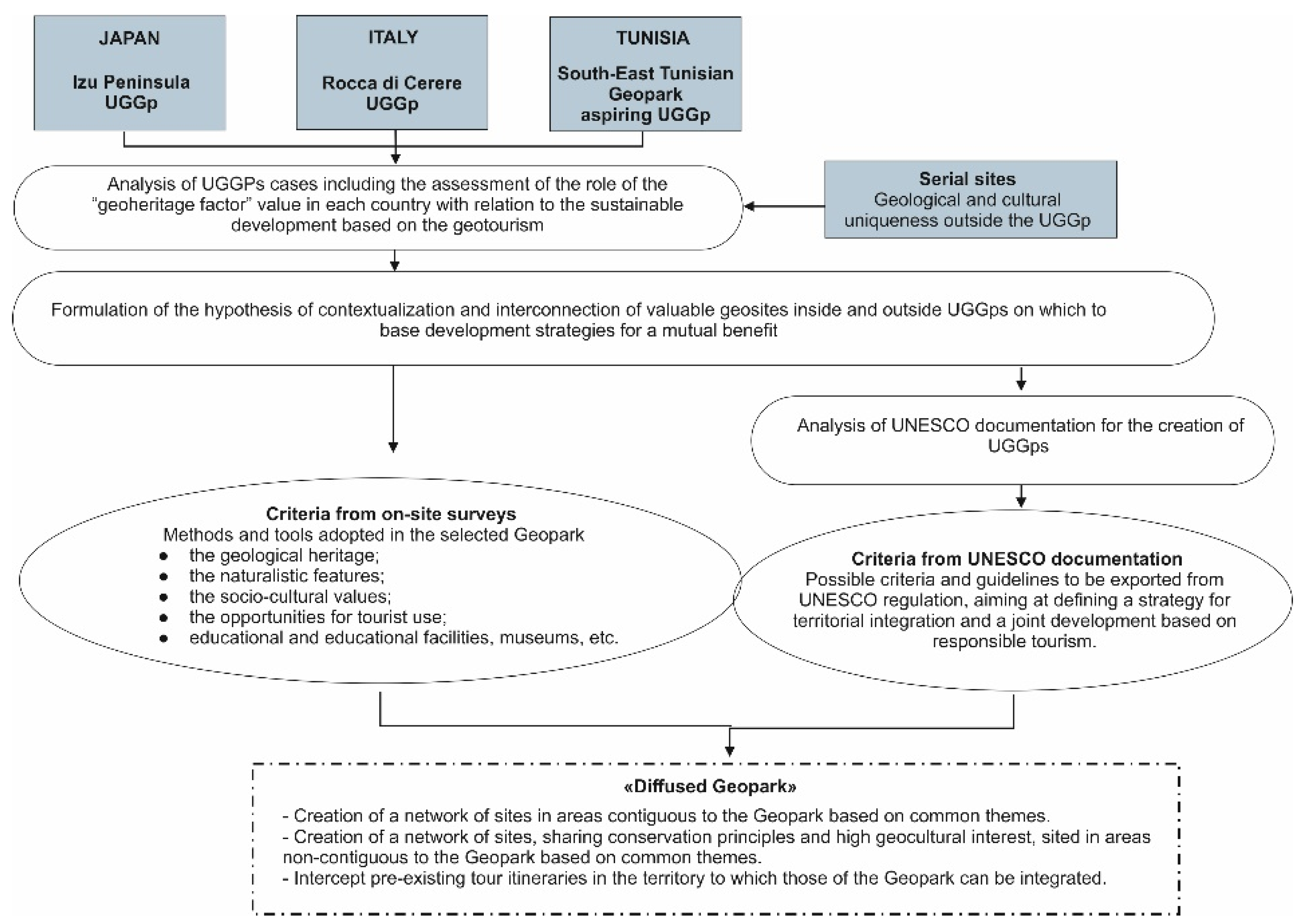
Based on data collected during onsite inspections by the authors in the above-mentioned three countries, the analysis was organized into five steps, as represented in the following flow chart (
Figure 1).
The first phase was dedicated to identifying and analyzing UGGPs cases, including assessing the role of the “geoheritage factor” value in each country in relation to sustainable development based on geotourism.
The second phase involved the formulation of the hypothesis of contextualization and interconnection of valuable geosites inside UGGps and outside (i.e., serial sites) on which to base development strategies for mutual benefit.
The third phase consisted in the analysis of UNESCO documentation for creating UGGps to identify possible criteria and guidelines to be exported from UNESCO regulation, aiming at defining a strategy for territorial integration and joint development based on responsible tourism.
The fourth phase regarded the analysis of case studies based on the documentation and information collected during the onsite visits. In particular, each case was analyzed concerning five elements:
geological heritage;
naturalistic features;
socio-cultural values;
opportunities for tourist use;
education and educational facilities, museums, etc.
The fifth regarded the formulation of the Diffused Geopark approach as a general framework enabling the evaluation of protection and management practices for the contextualization of UGGps in their geographical setting, to be specified from case to case.
3. Geoheritage and Geoparks in Italy, Japan and Tunisia: From the Hypothesis to the Validation of the Thesis
The abiotic and biotic components of the environment influence the cultural landscape, which is the result of human–earth interaction throughout history. Such a holistic interpretation of the landscape provides the indigenous resident population and tourists with a closer connection with the environment which they live in or visit, promoting awareness of the value of the place and the creation of territorial identity.
Geoheritage is a fundamental value for more general cultural heritage. From the integration of the values associated with any type of heritage, enrichment can be derived for interpretation and communication, as well as for the cultural opportunities for visitors. The relationship can also be reversed, with cultural values considered as superior, but this should not lead to the neglect of geodiversity and geoheritage aspects at these sites. This issue can be seen in many UNESCO sites, which were inscribed solely for their cultural value but may contain interesting landforms and rock outcrops [
25].
The research introduces the relationship between the culture and the history of the three countries considered—Italy, Japan and Tunisia—with their territories’ geomorphological characteristics being, surprisingly, very similar. For each country, a case study was selected and also analyzed on the basis of the results of onsite inspections by the authors and cooperative actions with local stakeholders and bodies as well. Selected case studies were: Rocca di Cerere UGPp, Izu Peninsula UGPp and the aspiring South-East Tunisian Geopark.
3.1. Italy: Rocca di Cerere UGGp Case Study
Italy has a distinct “geodiversity” due to its unique geological and geomorphological characteristics, which translates into a plethora of landscape peculiarities that express the territory’s cultural heritage [
26]. Italy is rich in examples of myths and legends associated with contexts in which the volcanic origin of the territory and its active manifestations have been critical in defining the long-term identity of places. Since ancient times, legends have grown up around the volcanic character of its territory, particularly in volcanic areas such as Sicily (
Figure 2), to justify phenomena such as earthquakes and other manifestations of volcanism.
This connection is evidenced by the importance placed on the protection and enhancement of geoheritage. Indeed, the island contains two UNESCO geosites—the Aeolian Islands (2000) and Mount Etna (2013)—each of which was chosen for “being one of the representative examples of great historical periods as evidence of life or geological processes”.
The presence of UGGps in Italy is linked to the evolution of national and international actions for the enhancement of geodiversity, leading to projects of mapping and classification of geological heritage aimed at safeguarding the integrity of natural and cultural heritage [
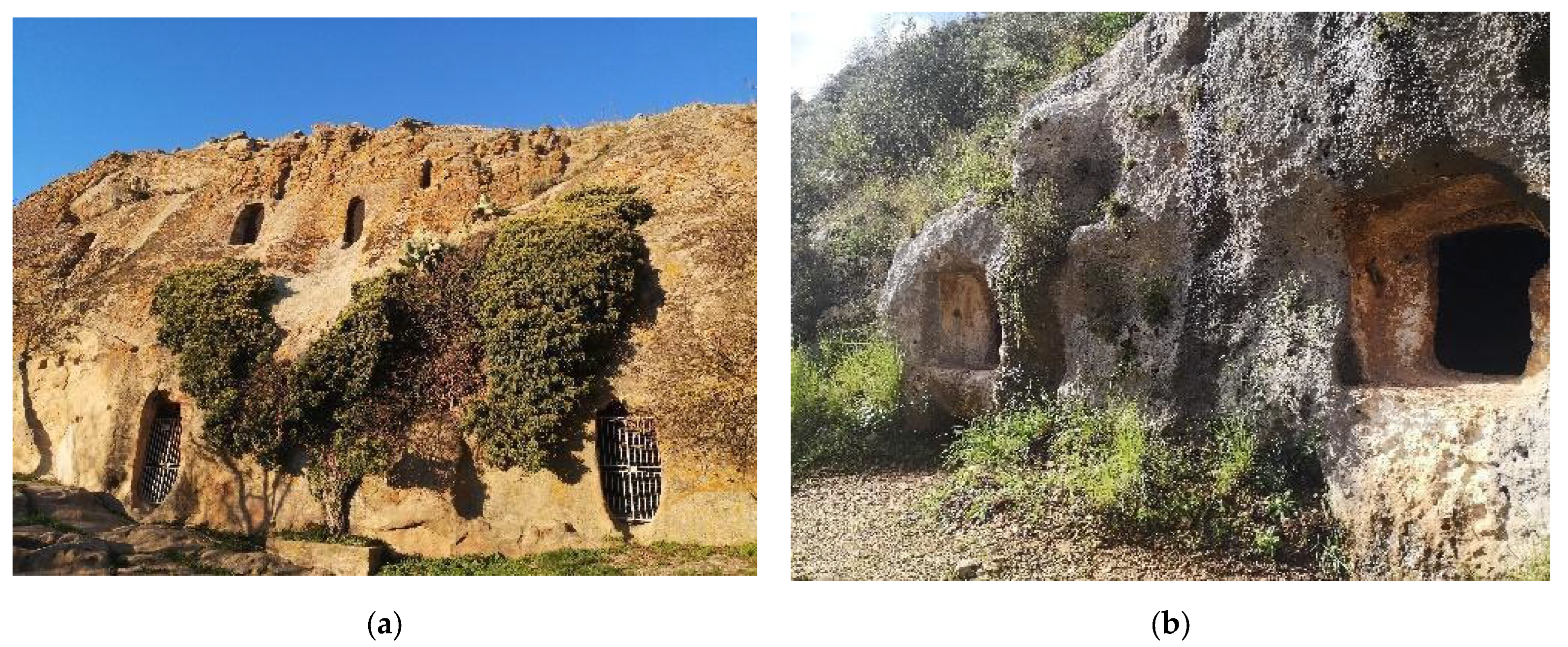
27]. However, not all homogenous geosites have been considered and protected in the same way. In Sicily, for example, the count of geosites nationally recognized includes the rock carved Necropolis of Pantalica, which, in 2005, was inscribed, together with the historical city center of Syracuse, in the UNESCO list as a cultural site, and the site of Gurfa cave in Alia, which is very similar to the previous one in terms of historical functions but enhanced as a geosite within the Madonie UGGp (
Figure 3). The Sicilian context contains 2 Geoparks—Madonie UGGp and Rocca di Cerere UGGp—in the context of the 11 on the entire Italian territory.
Sicily, where geology is the common thread in the reading and interpretation of the landscape, was the first region in Italy to adopt a legislative tool to protect places of great scientific value and geological beauty. It is no coincidence that there are two Geoparks on the island: Madonie Park and Rocca di Cerere Park. The latter became a Geopark in 2008 and has since demonstrated its full adherence and a convincing contribution to the European and Global Networks of Geoparks.
The key elements of this recognition are the extraordinary nature of its geological heritage, its high geodiversity, the presence of a sustainable development strategy implemented through the principles of sharing and collaboration with other local actors and intense geotourism activity that integrates and completes the proposals for environmental education.
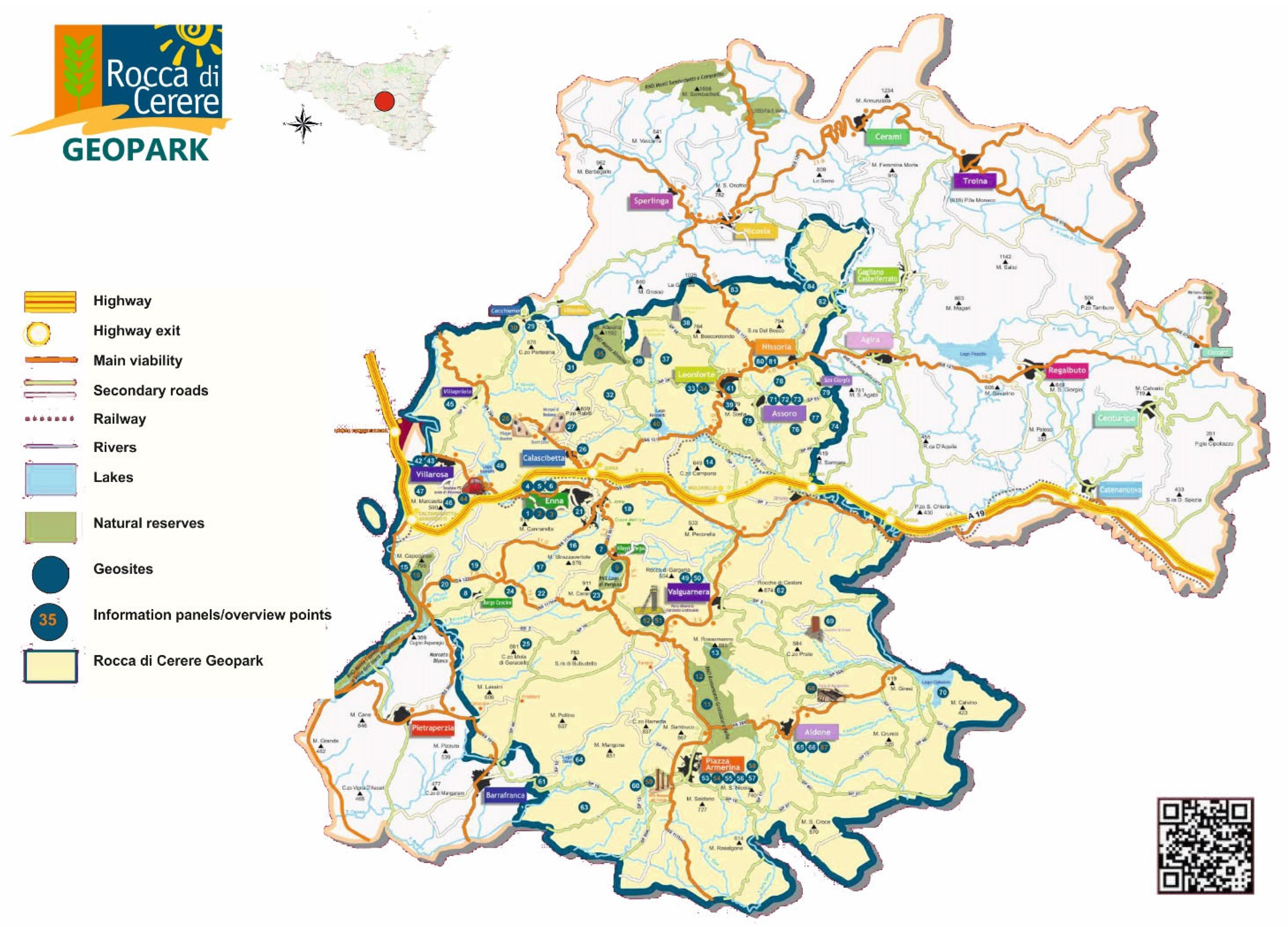
The Rocca di Cerere UNESCO Global Geopark (
Figure 4) area is located in the central zone of Sicily Region, on the Erei Mountains, and includes the towns of Enna, Piazza Armerina, Aidone, Valguarnera, Villarosa, Leonforte, Assoro, Nissoria and Calascibetta.
The name “Rocca di Cerere’’ was chosen because of the ancient consecration of this territory to the chthonic deities. All contents described in this sheet were developed within the framework of the research agreement between CNR-ISMed and Rocca di Cerere (ISMed 79/2022 prot. of 31 January 2022)—the data shown below are unpublished and were provided by Rocca di Cerere UGGps based on the above-mentioned agreement.
Even the indigenous inhabitants of Ancient Sicily, the Sicanians and the Sicels, worshipped figures related to the Earth and its Underworld. This is amply demonstrated by the types of tombs found in stone funeral chambers, collective fetal-position burials and the funeral ideology of an afterlife connected with the underworld. These forms of worship can be summarized with the Latin name of Ceres, the goddess known by the Greeks as Demeter, a deity that protected agriculture. She was worshipped on the highest peak of the city of Henna, on the Rocca di Cerere. The name, therefore, reflects the close relationship established through time between Mother Earth and people.
Geologically, the area covers the central part of the Sicilian foredeep between the Apennine–Maghreb chain and the lblean foreland. The Geopark area is characterized by its geological diversity. The northern area shows Triassic and flyshoid deposits with beautiful quartz arenite formations, while in the southern area, the presence of the gypsum-sulfurous plateau created during the Messinian crisis between 5.96 and 5.33 million years ago prevails. This crisis occurred due to a sudden drying up of the Mediterranean Sea with the consequent levels of cyclic deposition of powerful evaporites. The crisis ended with the return of the sea during the Zanclean period. The topography of the territory is typically hilly-mountainous, with more than 10% of the surface being over 700 m, with a maximum elevation (1192 m) at the top of Mt. Altesina. Surrounded by a mountainous perimeter, the landscape offers a rich mix of valleys, rivers, streams, lakes (including the Lake of Pergusa: the only natural lake in Sicily and location of the myth of Persephone), ancient rocky centers and hills that form part of the eastern plateaus that have been the theatre of intense human activity throughout the centuries. Their testimony defines the historical and cultural patrimony of the area today. Two of the most important classical archaeological sites of the Mediterranean can be found here: the Roman villa of Casale and the Greek polis of Morgantina, plus another 150 sites, including the Byzantine village of Canaletto or Malpasso and Realmese Necropolis from the Copper and Bronze Ages. The territory includes the only mining archaeological park on the island, Floristella-Grottacalda, several settlements of industrial archaeology and four protected areas of notable historical and natural value. The Geopark area is also rich in museums (Museum Train of Villarosa, Houses Museum of Villapriolo, Archaeological Museums of Aidone and Enna, ethno-anthropological Museum of Nissoria, permanent exhibition of mining culture of Piazza Armerina, etc.) and several castles, fortresses and churches, generally from medieval times (Castle of Lombardia, Federician Tower, Aragonese Castle, Swabian Castle, Gresti Castle, etc.). There, one can practice activities in nature (water skiing, sailing, canoeing, free climbing, MTB, birdwatching, etc.) and taste typical food products. The main educational center is located in Pergusa; other educational activities are located in Rossomanno, Calascibetta, Altesina, Train Museum and Nicoletti Lake.
The Rocca di Cerere UNESCO Global Geopark is represented by public and private entities working together in “districtual” form to promote the territory and its resources in new and innovative ways. These include proposing the development of geotourism through the creation of “pathways” aimed at valorizing and improving the fruition of the natural-geological, agro-alimentary, historical and cultural heritage in an integrated and sustainable way, including complementary services and facilities.
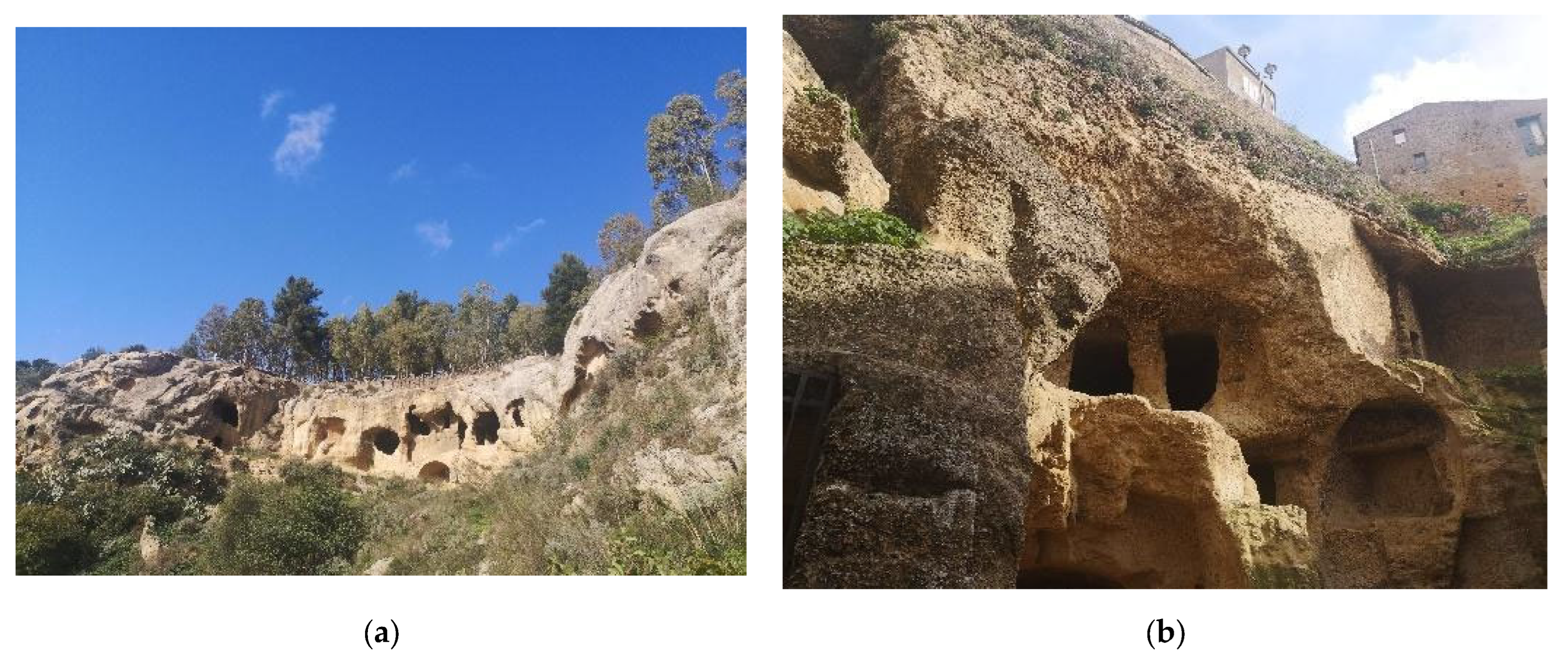
The Rocca di Cerere UGGp is a perfect example of a transboundary Geopark, and the recent proposal of the project Xibet, submitted by Calascibetta Municipality and supported by the Rocca di Cerere UGGp and the CNR—Institute for Studies on the Mediterranean (ISMed) (PNRR M1C3, CUP1: J35I22000000001, INTERVENTO 2.1) goes in the direction of linking the park with other regional serial sites, such as the caved Byzantine village and the Carceri (
Figure 5) grottoes. In this case, the local rock habitat is at the core of the planned regeneration strategy for small villages. It is a perfect example of different levels of reuse dedicated to the newborn class of Underground Built Heritage (UBH). This class includes various typologies of caved cultural elements whose reuse can generate sustainable local development [
28], in the attempt to valorize these cultural sites within the UNESCO Geopark.
In this proposal, a no-boundaries and inclusive approach was planned by pointing out the role of those artifacts within the local economic and local social context, the correspondent modus aedificandi and the geological factors rather than the limits belonging to a given geographical area. This is the first attempt for an innovative solution for enhancing anthropic geosites in a territorial asset characterized by serial geosites which strongly characterize the territorial asset, even outside the boundaries of the Geopark.
3.2. Japan: The Izu Peninsula Case Study
In Japan, the particular geographic position and its iconic morphology, due to the volcanic origins of the country, have historically influenced the area’s development, generating a strong identity relationship between the country and its incredible variety of geosites. The wide range of Japanese geosites includes natural elements, such as volcanoes and hot springs, and artificial sites, such as caved burials and mines, recently included in the UBH [
28]. In different ways, they all relate back to Japanese historical mythology and perfectly account for the national sense of place. Today, more than ever, those geosites are perceived as resources for economic development, the enhancement of the territory and culture.
As a consequence of its morphology and the efficient processes of governance and monitoring of these georesources carried out, within the list of 169 UNESCO Geoparks, Japan is one of the most represented among the 44 countries included, with its 9 Geoparks inscribed: Aso UGGp, Itoigawa UGGp, Izu Peninsula UGGp, Mt. Apoi UGGp, Muroto UGGp, Oki Islands UGGp, San’in Kaigan UGGp, Toya–Usu UGGp and Unzen Volcanic Area UGGp [
29].
Izu Peninsula UGGp is located at the northern edge of the Philippine Sea tectonic plate and in the southeast of Honshu Island, an area with a geological history of more than 20 million years. It is the meeting place of two active volcanic arcs and several natural phenomena linked to tectonic plate collisions, such as volcanic eruptions and earthquakes, significant geothermal activity and recurrent tsunamis. The effect of the northward movement of the Philippines Sea Plate and the collision with the Honshu Arc originated in the peninsula about 600,000 years ago. The continuous volcanic geological history of the area is unique in the world. The collision with the Honshu Arc led to an uplift of the topography, which has developed many active faults. Research has been of great importance to understanding active fault features. It is a mountainous area—the peninsula’s highest point is Mt. Banzaburō (1405 m)—with high rainfall and unique coastal topography. In the past, all these natural elements were considered to have a philosophical or religious significance, and they stimulated the building of more than 90 historical shrines. Today, the opportunities linked to this environment have transformed the area into one of Japan’s most important touristic destinations, including its historical sites, such as Shimoda, and hot springs destinations, such as Atami, Ito and Shuzenji. Tourism is currently the main element in the economic activity in the peninsula.
Izu Peninsula UGGp is the youngest Geopark of Japan, having been inscribed in the UNESCO list in 2018 [
30]. The valorization plan of the area, as it is described in the dossier developed by the local technical committee to support the inclusion in the UNESCO list [
31], of course, includes all the aspects connected to the geomorphology and volcanic activities typical of Geoparks, added to the main issues several linkages to local traditions and cultural elements. Both sites connected to the tangible and intangible cultural heritage of Izu Peninsula UGGp are considered. Special attention is given to those elements that have been historically adopted to manage all the functions connected to the given natural resources.
Izu Peninsula UGGp has been selected as a case study to test the Diffused Geopark approach because of its peculiar characteristics and youth. The UGGp includes a significant variety of geosites that resemble national serial ones, and it is managed following the most innovative valorization approaches. All these aspects have been tested during onsite visits, but, overall, the hypothesis of the research has been confuted with reference to the most representative types of Japanese geosites to verify if, in the youngest Japanese UGGp, their valorization also includes the role of gateway to homogenous national geosites.
The first example we studied is natural Japanese hot springs, those iconic water-based geosites connected to several national intangible cultural values, the so-called onsen. Onsen strongly characterize the terrestrial side of the peninsula, and the main locations linked to these geosites are: Rakujuen Genbeigawa, Hashiriyu and Atami area. In the area of Rakujuen Genbeigawa, the urban landscape is strongly influenced by underground water resources, which happens to be an identity symbol in locations such as Komo and Kohama ponds. Various surface lava flows, characterized by labyrinths of interwoven ropes, can be found around Mishima City. The unique urban river that crisscrosses the landscape of Genbeigawa is considered the city’s main character. Hashiriyu itself is connected with the presence of a rare tunnel-type thermal spring discovered about 1300 years ago: Hashiriyu (running hot spring). Atami was created due to the erosion of a large terrestrial volcano called the Taga Volcano. Hot springs and the Tanna Tunnel are some of the most popular tourist destinations in the city.
Onsen may feed public or private baths where people go to relax; they traditionally offer separate male and female spaces [
32]. When managed under concession by private owners, onsen are typically valorized within the so-called
ryokans. These traditional Japanese inns offer several facilities in continuity with the historical traditions that date back to the Edo period [
33]. The hospitality includes the typical dressing with
yukata robes and sandals, rooms with tatami mats, sliding paper doors, futon-style beds and the traditional multi-course dinners, the so-called
kaiseki ryori. Within Izu Peninsula UGGp many
ryokans have been established, and they all represent, at the same time, the optimization of the local thermal potentialities and the celebration of the iconic Japanese character. In this perspective, Izu Peninsula
raykans can be easily considered access doors to one of the most famous recreational activities in the country.
The second geosite tested is the Toi Gold Mine [
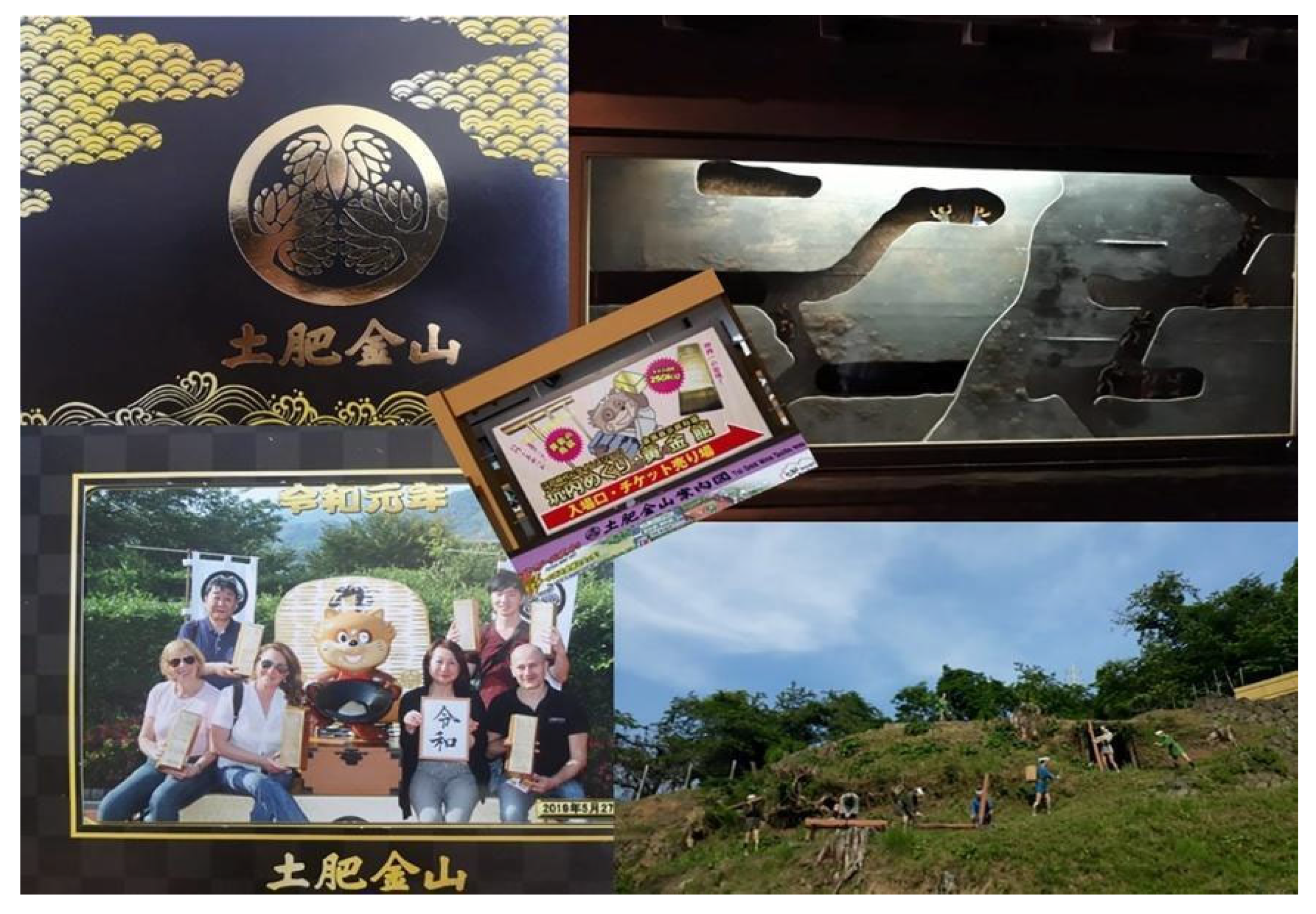
34], a dismissed gold mine that has been transformed into a didactic center for divulgation about the history of this geosite with reference to local socio/economic development. The enhancement process includes an immersive underground experience with several 1/1 characters and old machinery that simulate the main internal mine activities. Furthermore, the open-air path is animated by several personages; in this case, they represent the connection with the gold trade. The information center not only gives information about the history of the site throughout all its activity periods but contextualizes the geosite within the Japanese economic context and the global gold trade. In the future, other production sectors could also be integrated to emphasize the role of the site as gateway to the variegated sector of historical Japanese mines (
Figure 6). Concerning this specific site, we have to say that, even if the site has been successfully adopted as an access door to the gold mine and trade sectors, the opportunity for linking it to the wide range of Japanese dismissed mines, today enhanced as geosites or cultural sites, was missed. It is a lost opportunity since, in Japan, this sector also includes UNESCO sites such as the Itsukushima Shinto Shrine (UNESCO, 1996) [
35] and the Sites of Japan’s Meiji Industrial Revolution: Iron and Steel, Shipbuilding and Coal Mining (UNESCO, 2015) [
36].
The third geosite tested is Omuro Volcano, a dormant volcano. In the Izu Peninsula, it can be considered a geosite that represents the numerous Japanese volcanoes, including the Fuji Volcano, which is worldwide recognized as the symbol of Japan for its perfectly round and symmetrical shape and was inscribed in the UNESCO list as a cultural site in 2013 [
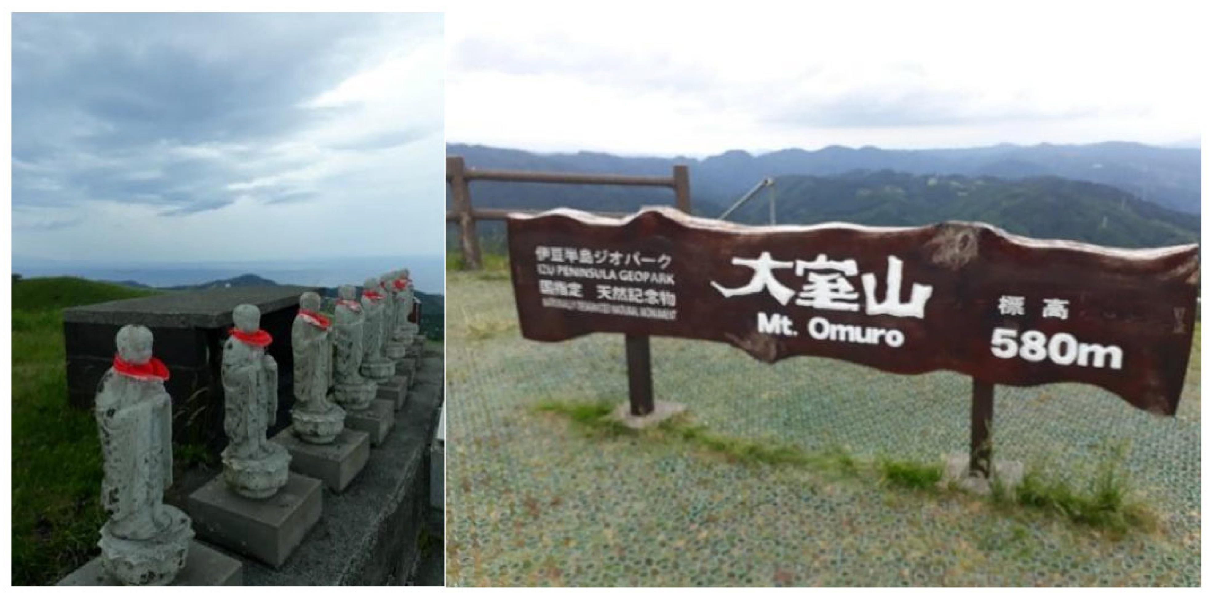
37]. Omuro Volcano is the most visited site in the Izu Peninsula UGGp; the site is a complex that includes a divulgation center, a lift to the top of the mountain, a secured path all around the crater of the extinct volcano and an archery range inside it. Several facilities are offered, such as shops and restaurants, and some religious elements have also been introduced. The divulgation center is organized with maps and interactive tools. Information and data are not limited to the Omuro volcano but contextualize the site within the Izu Peninsula UGGp and introduce essential elements about the geological history of the country as well. The family target of the Omuro site is confirmed by religious elements introduced in the most scenic location of the site. Eight life-size statues represent Jizo, the guardian deities of the children; visitors pray to them once they arrive on the top of the volcano to bless their children (
Figure 7).
Furthermore, the critical issues observed within the Izu Peninsula UGGp can be faced using the
Diffused Geopark approach. Even if a holistic approach to the valorization processes, both at spatial and temporal levels [
38], has been carried out concerning the above-mentioned natural elements, still, several critical issues have also been underlined with reference to the level of geo-conservation, the urban footprint of the nearby Tokyo area and the lack of awareness among the local population [
39]. Concerning this aspect, the Izu Peninsula case study reveals wider environmental problems connected to the valorization of geosites. The proximity of the major metropolitan complex of Tokyo has meant that the UGGp is perceived as a lung within reach of the congestion and pollution of the big city. Therefore, even if the availability of clean air is one of the recurring elements in the description of the park and its valorization, it also represents a risk in terms of gentrification and of environmental impact in general [
40].
Also, issues connected to the management of risks that may occur in the proximity of enhanced active geysers make the Izu Peninsula eligible to be a gateway to expertise in this sector. In detail, not only is the fire that broke out in Itoigawa Station a reminder of more general problems that can be connected with the enhancement of this type of geosites, but it also introduces the main issue of the need to develop best practices for monitoring and management of geosites in general [
41].
In conclusion, even if the valorization process in the Izu Peninsula UGGp is strongly market-oriented and includes several exogenous elements to reinforce the opportunities and the appeal for tourists, all the visited and analyzed geosites match the concept of
Diffused Geopark we introduced. It is possible the recurrent inclusion of several exogenous elements and the strong pressure on the natural resources are connected to the targeting of Tokyo tourists. On the other hand, the communication strategy adopted about the natural geopark is very effective. However, the principal focus is always the character of the area, even if it is not limited to it. Therefore, even if the need for a more conscious involvement of local communities for the reinforcement of the sense of place [
42,
43] is confirmed, Izu Peninsula UGGp can be considered a symbol of the Japanese approach to the relationships of local UGGps with their boundaries and the general national, environmental, social and economic context as well.
The Japanese case study confirms the thesis of the research, demonstrating how, in the case of Izu Peninsula UGGp, the
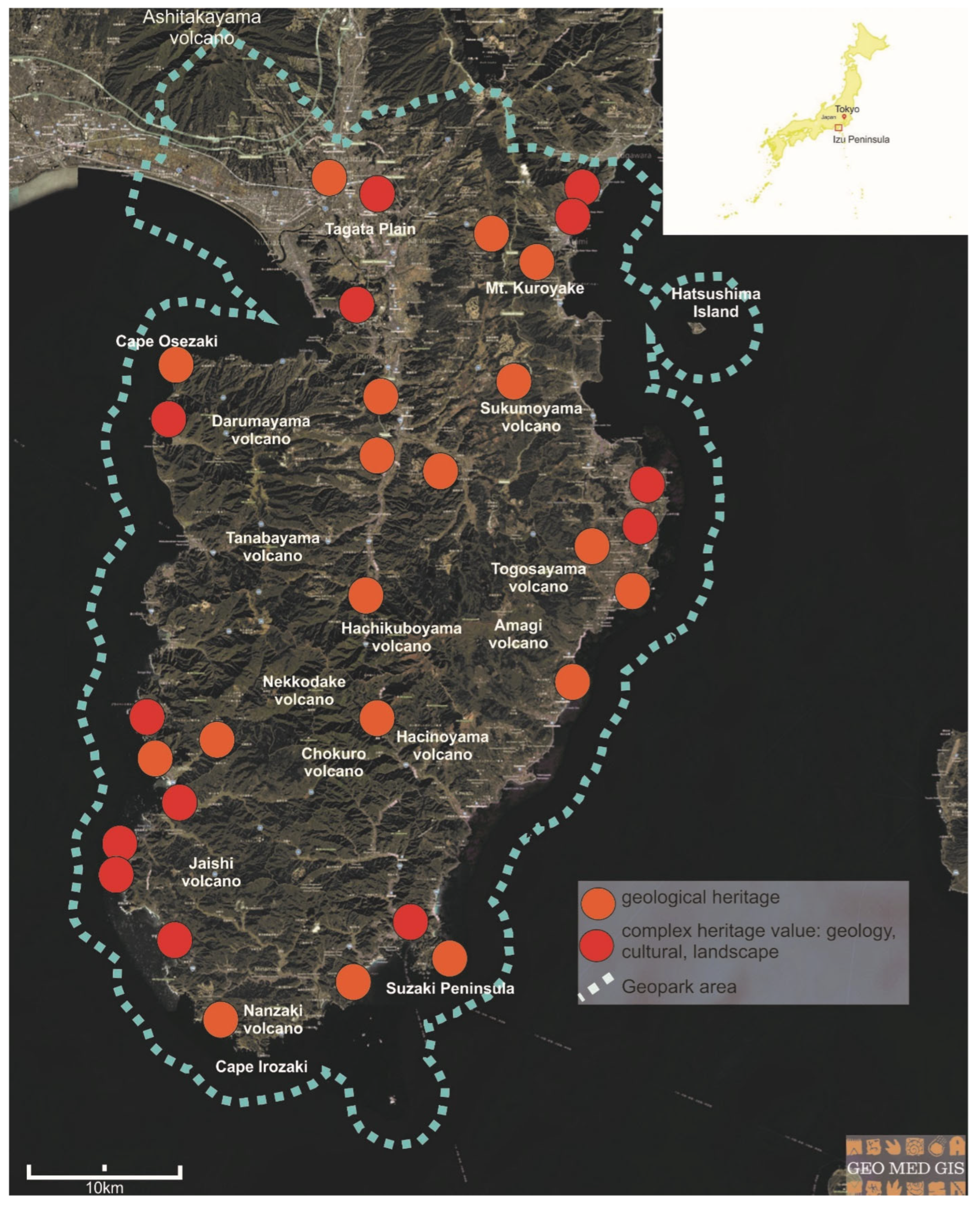
Diffused Geopark approach has already been profitably adopted within several enhancement strategies and, as an effect of them, in marketing actions toward the promotion of the correspondent sites. However, as emerged from the study, this is not a widespread approach, and there are several more sites that could be profitably adopted as access doors to national sites as well, while always respecting the peculiar character of Izu Peninsula UGGps (
Figure 8).
3.3. Tunisia: The Aspiring South-East Tunisian Geopark
Due to its geological and geographical conformation, Tunisia exhibits a great variety of natural and cultural landscapes. Over time, over-exploitation of water resources and anthropogenic pressures have led to conserving and rehabilitating biodiversity being prioritized on a national scale through legislation.
Since the 1990s, the Office National des Mines (ONM) has enhanced geological heritage. After studies on four potential sites for classification as Geoparks in Tunisia (El Kef, Ichkeul, Zaghouan, Tataouine) [
44], ONM decided to launch the first “Geopark” in Tunisia as part of the Protection of the Geological Heritage of the South-East Tunisian Country. It integrates south-eastern Tunisia’s natural, archaeological and geological wealth with a dual objective: protecting this natural and cultural heritage and its exploitation as a vector for economic development. Data and information have been collected thanks to Dr. Mohsen Ben Assine, from the ONM, in charge of the Geopark project.
In the years following 1996, many important paleontological discoveries prompted the ONM to commit, in 2014, to establishing the first Tunisian Geopark [
45,
46,
47]. Since November 2015, the Geopark label has become a veritable UNESCO program, with the roadmap for establishing UNESCO Geopark elaborated within the convention ONM-Swisscontact [
48]. In 2021, Tunisia’s candidacy was retained (rank 2) because of the importance of the region’s heritage potential (geological and cultural) within the framework of the UNESCO/GGN (Global Geoparks Network) initiative by ensuring the support of a certain number of initiatives for the “Aspiring Geopark’’ on the African continent by a customized and free accompaniment up to the submission of the candidature document. This initiative provides technical assistance and support until the candidature dossier is submitted to UNESCO. Despite the numerous criticalities related to the Geopark, innumerable associations and initiatives, with local or international partnerships, aim to promote sustainable tourism, which enhances the region’s natural, historical-cultural, tangible and intangible heritage. At the same time, many actions are aimed at educational activities and training courses for young graduates and women to create new professional skills and improve the quality of life in the region.
In this paper, the Tunisian park is a different case study from the other two. It allowed us to analyze the potentials and criticalities of the aspiring Geopark in a phase of the initial steps of Geopark identification and its impact on the territory.
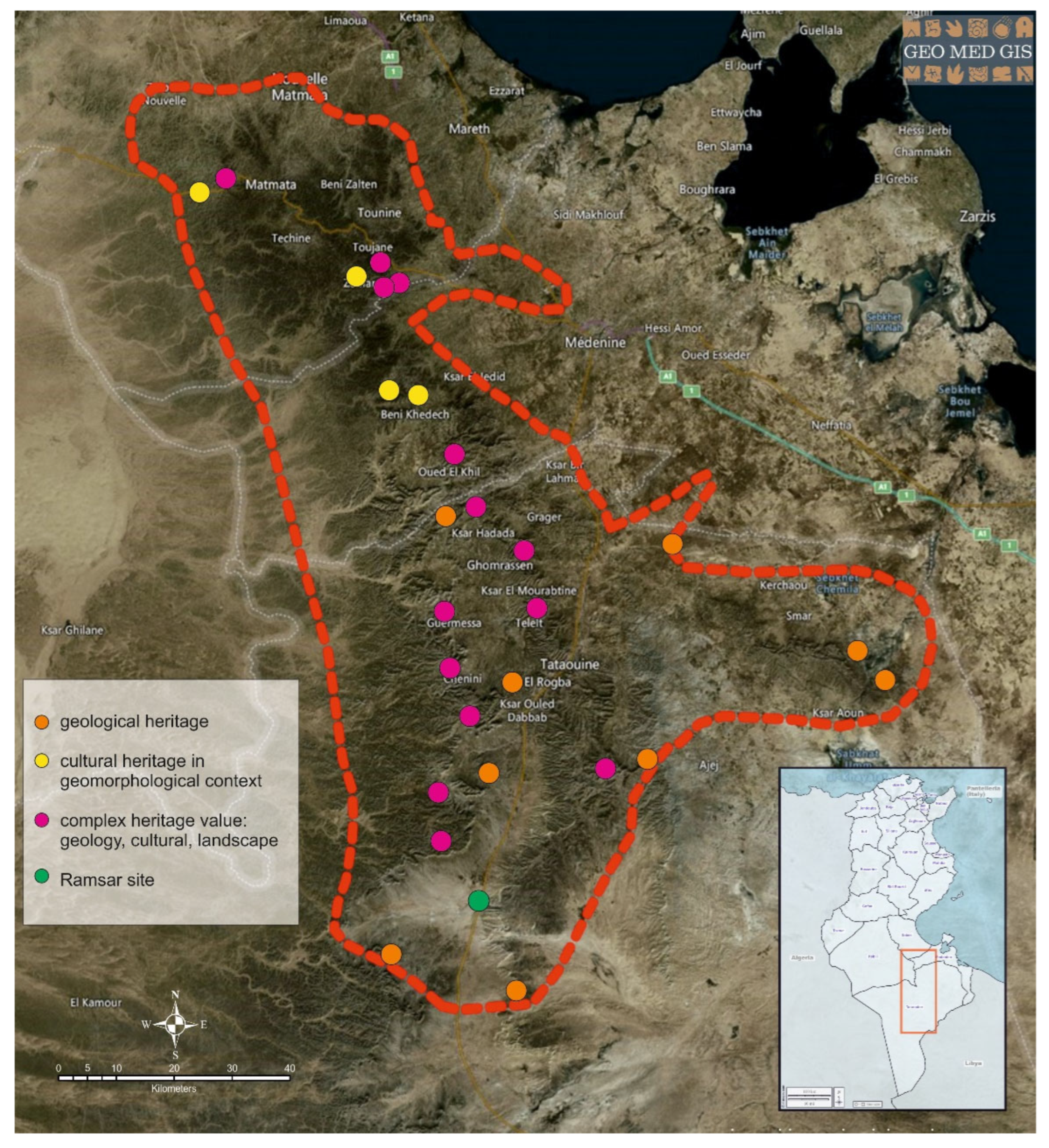
The South-East Tunisian Geopark (
Figure 9) covers the governorates of Gabès, Medenine and Tataouine. Its delimitation was based essentially on geological criteria. The structural reliefs offer an exceptional range of varied geomorphological contexts (cuestas, valleys, basins), to which societies have adapted by developing practices, infrastructures (hydraulics, for example) and forms of habitat (troglodyte perched villages, ksour), which today constitute a cultural heritage of exceptional value.
Jebel Dahar is located to the south of the great Chotts depression. It separates it from the folds of the Tunisian Atlas, marks the first terrains of the Saharan platform and constitutes a precious window into geological history. The Dahar is one of the most important landforms in south-eastern Tunisia. It consists of two or more stepped plateaus (cuesta), roughly aligned NNW-SSE and culminating at 713 m a.s.l. at Kef Ennsoura. In the southern part, a quadruple cuesta split south of Tataouine, west of Jebel Abiadh, with several buttes, bands and small ranges, such as Jebel Tebaga of Medenine (320 m a.s.l.).
The different morphostructural units (the Tataouine Graben, the Medenine Horst, part of the Jeffara and the Dahar Plateau) cover the broadest possible spectrum of geological time. Geologically, the geological series of Jebel Dahar constitutes a heritage of universal value and an archive of the evolution of natural landscapes and living beings, which occupied them for approximately 250 million years. Since the beginning of the Cenozoic era, the Dahar has emerged and evolved under the effect of continental morphogenic agents, wind, and runoff, which has led to the shaping of multiple well-expressed landforms. During the Anthropocene, humanity has progressively occupied Jebel Dahar and marked the landscape with rich cultural heritage vestiges.
The Paleozoic outcrops, exceptionally well preserved and exposed, are contemporary with the origin and expansion of the old Tethys Ocean, which appeared during one of the most important geological events in the history of our planet: the great rifting at the end of the Paleozoic and beginning of the Mesozoic. The exceptional paleontological and sedimentological heritage allowed a reconstitution and a complete “reading” of the paleoenvironments and the fauna and flora associated with the opening of the southern margin of the Tethys. The paleontological and sedimentological site of Jebel Tebaga in Medenine is the only Upper Permian marine outcrop on the African continent. It is included in the tentative list of World Heritage candidate sites submitted by Tunisia [
49].
Another site of exceptional value is the palaeobotanical site of Jebel Merbah el Asfer [
50,
51]. With the richness of its fossiliferous deposits, a new genus of Salviniaceae and five new species were proposed.
The importance of geological and geomorphological sites in this area constitutes a strong point for this Geopark (
Figure 10).
The cultural landscape resulting from human–territory interaction in these difficult geomorphological and climatic conditions [
52,
53] contributes to enriching the value of geoheritage. With its tangible and intangible heritage, the cultural heritage assumes a fundamental role in the geocultural sites [
54]. The attention paid to the agricultural production of the territory leads to understanding the identity landscape characterized by the fig and olive tree and the techniques of the “jessour” [
53,
55], controlling run-off water and collecting rainwater for domestic or agricultural use (
Figure 11).
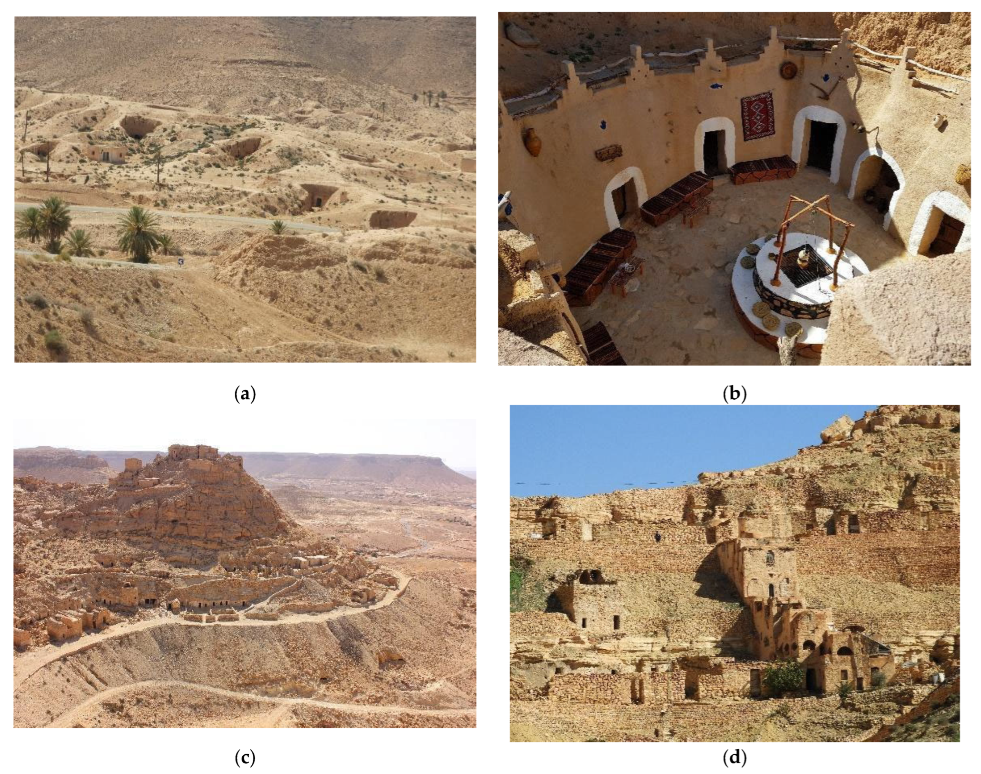
Even the typical troglodytic habitat of the Dahar is strictly linked to the scorching climate, geology and geomorphology. There are two categories of construction mode, mainly related to the lithology characteristics [
53,
55]. In the Matmata region, many geomorphological sites are essential in reconstructing the paleoenvironment’s history in the Quaternary period. The vertico-lateral troglodyte dwellings are dug vertically into the aeolian silt deposits (loess). In the Tataouine sector, horizontal or lateral troglodyte dwellings are dug horizontally into the soft hillside strata, in cuesta morphology.
They constitute troglodyte perched villages (Chenini, Douiret, Guermessa, etc.) or small family concentrations dispersed in the mountains (
Figure 12). Some villages, such as Chenini, are still inhabited, and constitute authentic geocultural sites [
54] of universal value both for the type of maintained and functional dwellings and the scientific, paleontological value of the surroundings with their dinosaur foot traces. The value of this cultural geosite is also enhanced by the presence of one of the sites around the Mediterranean supposed to have housed the Sleeping Seven in Muslim and Christian theology [
56].
Over the past four decades, troglodyte habitats were progressively abandoned because of socio-economic changes and important migration trends. However, today, some of them are also maintained for housing, as well as for oil mills, craft workshops or warehouses, or restored to create guest houses and museums.
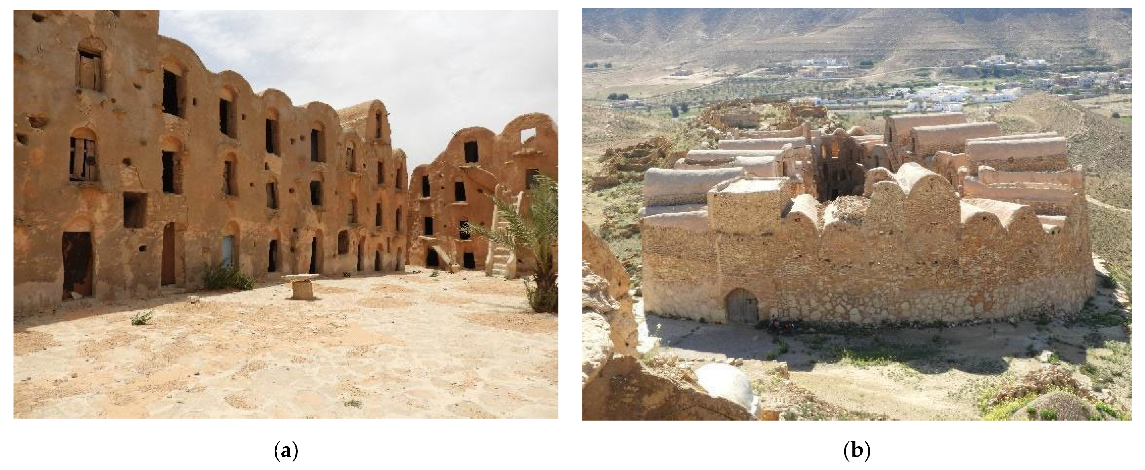
In the area, the third essential element of the geoheritage are the Gsour: solid constructions inherited from nomadic times, which testify to the genius of the region’s inhabitants and their expertise. Characterized by the same architectural specificity in the entire region, they were intended to store food harvests and occasionally as a refuge for the Berber populations during inter-tribal conflicts and tensions [
57]. The 82 Gasr are distributed between the governorate of Tataouine (56 Gasr) and Medenine (mainly in the delegation of Beni Khédache) and can be divided into two main types. The Gasr of the plain, mainly in Jeffara and El-Ouara regions, are generally used as granaries for the nomadic pastoralists. The mountain Gasr (Jebel) are perched on the heights of the Dahar mountain range and the surrounding hills. They are real fortresses (Qalâa) for the mountain tribes (Berbers and Arabs) who for centuries have used them as granaries and refuges during periods of inter-tribal unrest (
Figure 13) [
57]. Today, the Gasr heritage of south-eastern Tunisia is currently undergoing a procedure for inclusion in UNESCO’s World Heritage List.
The intangible cultural heritage is well evidenced by the importance of female artistry, as seen in the weaving of carpets and fabrics, and the veneer and traditional use of the ‘Gûeddim’ forage resource linked to male craftsmanship.
In addition to the Museum of the Memory of the Earth, created by the ONM, the IRA Natural Museum and numerous museums dedicated to cultural heritage and local traditions are essential in the territory. These are often set up and managed by private individuals and sometimes do not exhibit good content organization levels. However, it should be emphasized that they reflect a new awareness of inhabitants of safeguarding their territorial heritage and making it exploitable for a new form of cultural tourism. In reality, few tourist information points illustrate the opportunities for tourism in the area.
Some local tourist agencies and associations offer trekking, for sport and adventure. With the support of foreign partners, some local actors are proposing itineraries of natural and cultural interest to develop sustainable tourism. The Federation of Tourism (FTAD) is important in the region, which brings together local tourist service agents to present a unified tourist offer that highlights the many facets of the region’s heritage, following a quality charter [
58].
Sharing the region’s rich natural and cultural-historical heritage through web portals such as GEO MED GIS and GeoTourism Dahar (developed by FTAD with Swisscontact) contributes to disseminating geoheritage online and on-site and the development of geotourism opportunities in the region.
4. “Diffused Geopark” and Access Doors to Serial Sites: The Framework
As our research has highlighted, geotourism is continuously growing in importance in the economies of Italy, Japan and Tunisia, thus resulting in greater attention to interpretation, communication and enhancement practices of geoheritage sites, UGGPs and selected case studies as well, of course.
This is particularly true for Tunisia, where geo-patrimonial research is still relatively limited, the country does not have a national inventory of geoheritage; the concept was introduced into the national debate thanks to a new sensitiveness of the Government, the Office National des Mines, as an outcome of the beginning of the UNESCO tentative listing of the Geopark.
The Tunisian case punctually offers evidence of the extent to which the presence of a UGP can affect a territory on various scales in various ways. The theory of the Diffused Geopark is based on this assumption. A UNESCO property forms part of a broader territorial system, potentially having a strong natural, social and cultural link. A Diffused Geopark can act as a territorial hub, where best practices globally recognized and tested can be shared and learned, and concepts such as integration and networking might be integrated on multiple territorial scales. This would mean laying the foundations for triggering an aggregation mechanism of valuable territorial enclaves, not included in the Geopark area but potentially integrable, as satellites of the main attractions, i.e., Geoparks. An effective addition to the park can avoid being excluded, as a change in size for UGGp is potentially admitted during the revalidation process, by proving how the new area still fulfils the criteria for a UGGp.
The analysis conducted starting from the theory about the SDGs associated with the Geoparks and the guidelines for creating UGGp was rethought from this perspective, with a focus on the development of geotourism. Geotourism, as responsible tourism, is one of the economic activities linked to the parks and one of the most sustainable, because it specifically focuses on geology and the landscape [
59], aiming to promote, understand, appreciate and preserve the environment and culture [
60], giving an area of interest its ‘sense of place’ [
61]. In this phase, it should be emphasized that a fundamental aspect of geotourism is integrity, whose identification and classification are fundamental for the geoconservation strategy [
62].
The value of geoheritage is linked to the “process of heritage creation” by the scientific, civil and political communities [
54]. As part of the inventory process aimed at planning and managing geotourism, an assessment must be made for each element of the geoheritage, with regards to its importance to human society, its protection needs and the balance between its conservation needs and geotourist use [
63].
Even in our proposal for a Diffused Geopark, the basic assumption is to enhance the close link between geological heritage and cultural heritage in their complementarity. Some main criteria codified from UGGps were analyzed and reinterpreted as follows.
Networking, nurturing partnerships, and sharing of good practices. A Geopark’s role in a territory varies depending on its status and position in national administration. Nonetheless, it has to act as an umbrella for promoting each inner path and network of sites of interest and facilities such as information and accommodation. It is also expected to support cultural and educational infrastructures and human capital as well. Regarding this last aspect, we refer to indigenous and minority groups, local cooperatives, associations and any human aggregation that interacts with nature and culture of the area. This new vision should facilitate the coordination of their activities, promote new collaborations between these features and support the development of local synergies and new products, eventually acting as an engine for local sustainable development. Adequate levels of territorial integration of the UGGp could ensure that these practices and the related know-how were invested in to benefit territorial realities outside the UNESCO property. After all, knowledge transfer is already part of the UGGps mission, while remaining confined to the scope of the global network. Within these networks, the Geoparks develop synergies, common products and initiatives; magnify their visibility and influence; transfer knowledge and good practices; and organize capacity-building activities [
17]. Similar activities could be conceived and organized locally, from the Geopark, to affect a territory’s development deeply. Furthermore, as nodes of a global network, Geoparks could stimulate the internationalization of lesser-known territories—including their typical products and artefacts—attracting them out of the shadow cone they often find themselves in.
Local community participation—UGGps could work as models of a bottom-up or community-led approach toward local economic growth. It has emerged that the success of social protection and participation actions, up to the very acceptance of the creation of a Geopark, depends on the understanding and recognition of certain values and the sharing of benefits. They include the economic ones resulting from it, not only at the local level but sometimes also at the provincial, regional or national level. Active involvement of communities as key actors in joint tourism enhancement initiatives between the Geopark and other relevant sites in the surroundings could make the difference, determining their success and making communication more incisive.
Integration and interpretation—use of geoheritage with all other aspects of an area’s natural and cultural heritage in a broader context. If framed in a broader context, UGGps could take advantage and enrich themselves with new elements on which to base their interpretation, making communication more incisive to stimulate the identification and sense of care of a territory and its communities for the park itself. From common traits—natural, historical-cultural, etc.—sites of a specific importance could be selected and networked with the Geopark, building main narrative strands for the narration of the territory. Moreover, the consequent benefit would be twofold. On the one hand, it would be possible to organize an integrated tourist opportunity in the territory, which could also benefit, for example, if the park would be integrated into historical and cultural itineraries with a consolidated reputation. On the other hand, a mechanism of aggregation of valuable territorial enclaves, not included in the Park area but potentially integrable, as satellites of the main attractions would be activated.
Consequently, three hypotheses of integrated enhancement of geological and cultural heritage have been identified, as described below.
Creation of a network of sites, sharing conservation principles and high geocultural interest, situated in areas contiguous with the Geopark based on common themes. In the Sicilian Geopark, the theme of the mining culture was enhanced in relation to the geological peculiarities, based on which a fruition itinerary was organized. This itinerary could be extended beyond the boundaries of UNESCO property to integrate the valuable cultural and geological heritage widespread in its geographical setting, improve its promotion and internationalization and spread the consequent economic benefits throughout the territory.
Creation of a network of sites, sharing conservation principles and high geocultural interest, situated in areas noncontiguous with the Geopark based on common themes.
The themes do not have to be strictly scientific. They can be themes such as art, literature or cinema that act as attractors and lead the tourist to ‘discover’ content they were not looking for; thus, he increases his knowledge. In Tunisia, an interesting example is the “Star Wars” sites: a destination for many tourists from all over the world who visit southern Tunisia in search of the sites where the various episodes were filmed. The locations in the South-East Tunisian Geopark lead tourists to discover the cultural heritage of Ksar Haddada (Tataouine) and the Hotel Sidi-Idriss (Matmata); the numerous other sets in the governorates of Tozeur, Medenine and Djerba Island lead tourists to discover important sites of high natural and cultural-historical value in areas, which in reality have no other connection with the Geopark.
Intercepting pre-existing tour itineraries in the territory to the Geopark can be integrated to enhance their effectiveness and attractiveness.
Concerning this last aspect, for example, the Sicilian case study intercepts the historical path of Via Francigena and the paths for soft mobility prepared by the Tourist Observatory—Tourism, Sport and Entertainment Department of the Sicilian Region, available through the relative webGIS [
64]. Adopting preexistent routes can be an excellent opportunity to integrate homogenous elements inside and outside the UGGps, since our approach supports the preferential use of routes that promote sustainable tourism, in line with the goals of geotourism.
5. Conclusions
The research on the UNESCO UGGps topic highlighted their extraordinary potential in terms of networking and as a driving force for local economies, which, however, limit their effect within the boundaries of the property itself. Our thesis was based on the integrating the UGGp into its geographical setting to enhance its role and multiply the positive effects on a broader scale, both at a regional and national level. Based on the concept of Diffused Geopark, the proposed approach intends to be a possible solution towards the protection and implementation of dedicated management practices for the benefit of local economies and internationalization of lesser-known contexts.
From this theoretical framework, the research continued with the field study to verify its applicability and effectiveness in the selected case studies. From this perspective, particularly the Italian and Japanese cases have returned significant data. They confirm the existence of an open dialogue between the UGGps and the geographical setting, based on the commonality of geological, biological and anthropogenic factors and their respective intangible values, in which to invest for the dual benefit of the park itself and the territory on a larger scale.
In the Tunisian case, which is very peculiar, we have seen how this dialogue attitude has been considered already in the planning phase, and we sincerely hope that this approach will be continued in the phase of creation and systemization as well.
Based on the evidence gathered, the usefulness of investing in this research hypothesis is shown, and structuring the theoretical observations relating to the type of relationships with the UGGps considered can establish their geographical context. In the form of recommendations, they will be transferred to the administrations of the Geoparks considered and evaluated end enhanced in the context of the joint fieldwork.
As demonstrated by the given examples regarding case studies in Italy, Japan and Tunisia, geosites included in the correspondent UGGPs are representative of regions or regional types, and that connection, sometimes, is already included in the enhancement processes for a mutual benefit. Based on this evidence and the validation of our thesis, we would suggest the standardization of these procedures to optimize the potentiality of multiple and serial sites inside and outside UGGPs.
Thus, our analysis was intended to act as the first step of codification of good integration practices, whose usefulness should be assessed from case to case and which it is hoped, in the future, will be able to be implemented in the course of ongoing projects.
