Article

The Seat of the Roman Governor at Carnuntum (Pannonia superior)

by
Christian Gugl
1,2,*,
Mario Wallner
1,3,*,
Alois Hinterleitner
1,4 and
Wolfgang Neubauer
1,3
1
Ludwig Boltzmann Institute for Archaeological Prospection and Virtual Archaeology, Hohe Warte 38, A-1190 Vienna, Austria
2
Austrian Archaeological Institute (ÖAI), Austrian Academy of Sciences (ÖAW), Hollandstraße 11-13, A-1020 Vienna, Austria
3
Vienna Institute for Archaeological Science & Institute for Prehistory and Historic Archaeology, University of Vienna, Franz-Klein-Gasse 1, A-1190 Vienna, Austria
4
Central Institute for Meteorology and Geodynamics, Archeo Prospections®, Hohe Warte 38, A-1190 Vienna, Austria
*
Authors to whom correspondence should be addressed.
Heritage 2021, 4(4), 3009-3031; https://doi.org/10.3390/heritage4040168
Submission received: 31 August 2021 / Revised: 26 September 2021 / Accepted: 27 September 2021 / Published: 1 October 2021
(This article belongs to the Collection Feature Papers)

Abstract

:
The Roman site of Carnuntum was once a flourishing center on the frontiers of the Roman Empire. In its heyday as the capital of the province of Pannonia superior, Carnuntum probably covered an area of almost 9 km2. The whole site was divided into a military settlement (castra and canabae legionis) and a civil town (municipium/colonia). Through a large-scale archaeological prospection project, this huge area could be investigated and analyzed in great detail using a wide variety of nondestructive prospection methods. One of the main discoveries of the project was observed in the military settlement, where it was possible to identify a previously unknown military camp, interpreted as the garrison of the governor’s guard, the castra singularium. Through the topographic analysis of the immediate surroundings, the Roman fort was determined to be embedded in a large administrative complex related to the governor’s seat in Carnuntum. This article presents these new discoveries and shows what an important part they formed in the administration of the Roman province of Upper Pannonia.

1. Introduction

In spring 2022, the Museum Carnuntinum in Bad Deutsch-Altenburg (Austria) will reopen with a new permanent exhibition. Archaeological exhibitions that focus on the Roman city and its inhabitants always offer a good opportunity to give the interested public an overview of the state of research on one of the largest Roman sites on the Danube. Driven by the desire to present the ancient settlement in its entirety, one has already ventured to reconstruct Carnuntum several times, especially in exhibitions [1]. For the last large permanent exhibition on Carnuntum in 1992, a large wooden model on a scale of 1:600 was produced showing the location of the known monuments. At the same time, an attempt was made to create a graphical presentation that would give the museum visitor an artistically inspired overall impression of the ancient site (Figure 1). In the following decades, our knowledge of the appearance of Carnuntum has changed fundamentally. Finally, for the Country Exhibition of Lower Austria in 2011, a complete model of Carnuntum was produced on a scale of 1:300. This 23 m × 15 m model, set up in the outdoor area of the Archaeological Park, is based on a virtual reconstruction of the site and the buildings (Figure 2), which in turn was based on the current excavation and prospection results, especially the results of aerial archaeology.
In this article, a sub-area of the Roman settlement is selected, illustrating how our knowledge of the topography of Carnuntum has expanded enormously, especially as a result of the integrated archaeological prospection project carried out by the Ludwig Boltzmann Institute for Archaeological Prospection and Virtual Archaeology (LBI ArchPro). The seat of the Roman governor and in particular the barracks of the governor’s guard, discovered in 2013, are neither found on the older plans nor on the settlement reconstructions of Carnuntum. Especially when one compares these new discoveries with the sometimes-sparse building remains in other Roman provinces, one becomes aware of the significance of the architectural ensemble found in Carnuntum. In this respect, the chosen example demonstrates in particular how modern archaeology can contribute many new insights, for example into Roman military architecture and provincial administration.

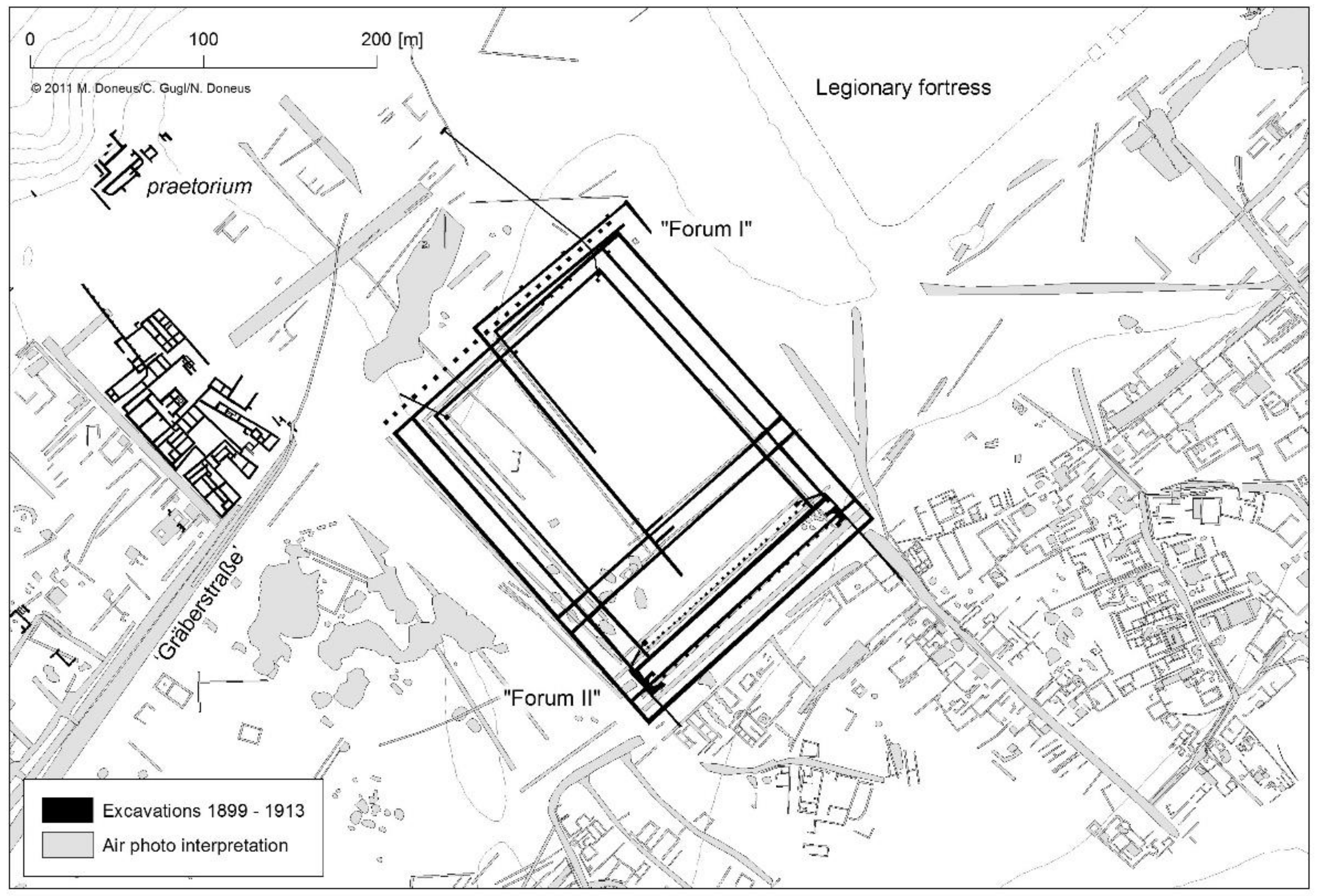
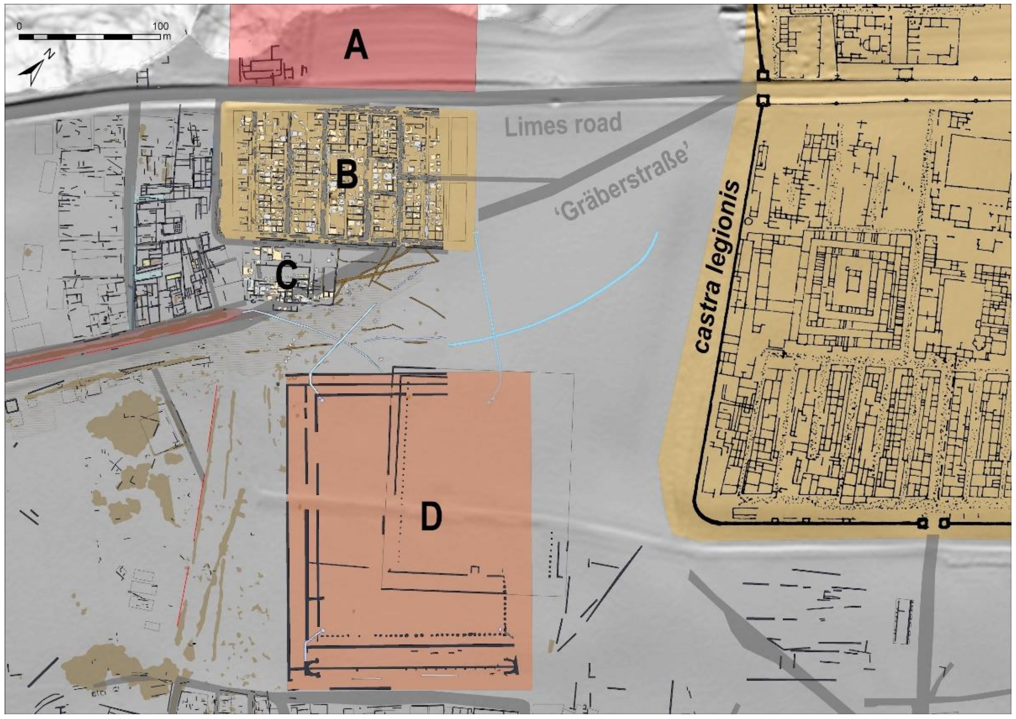
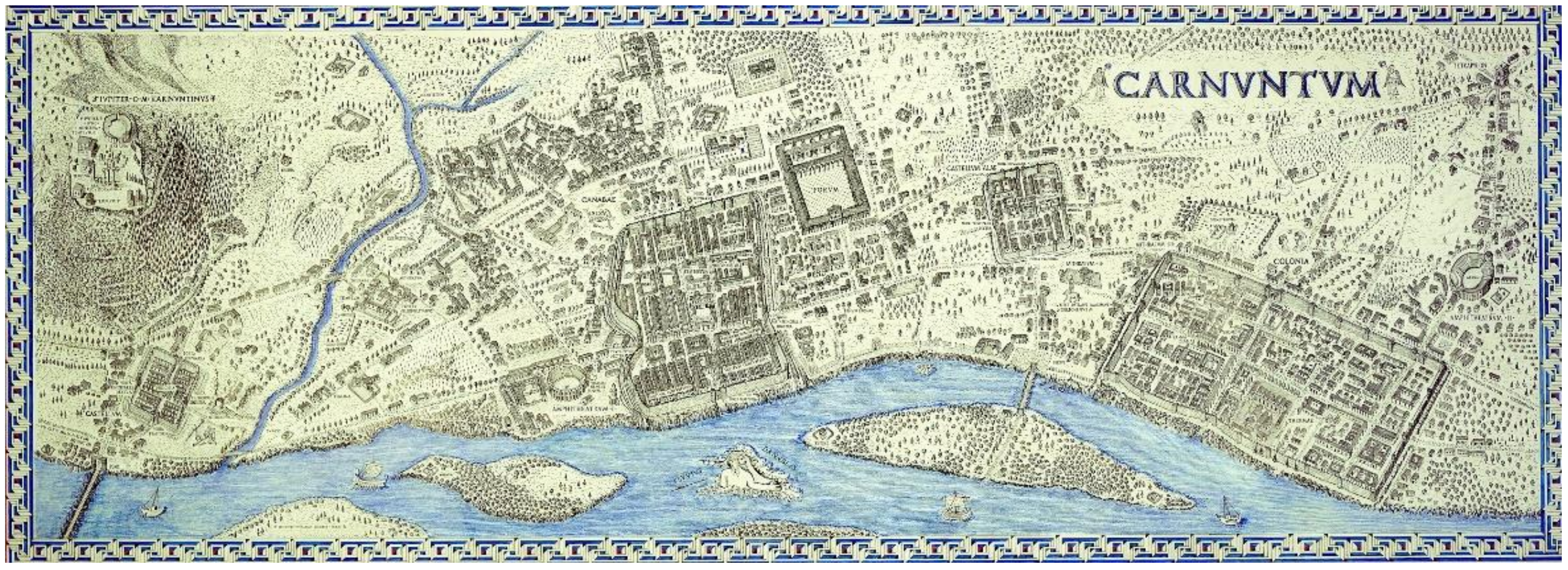
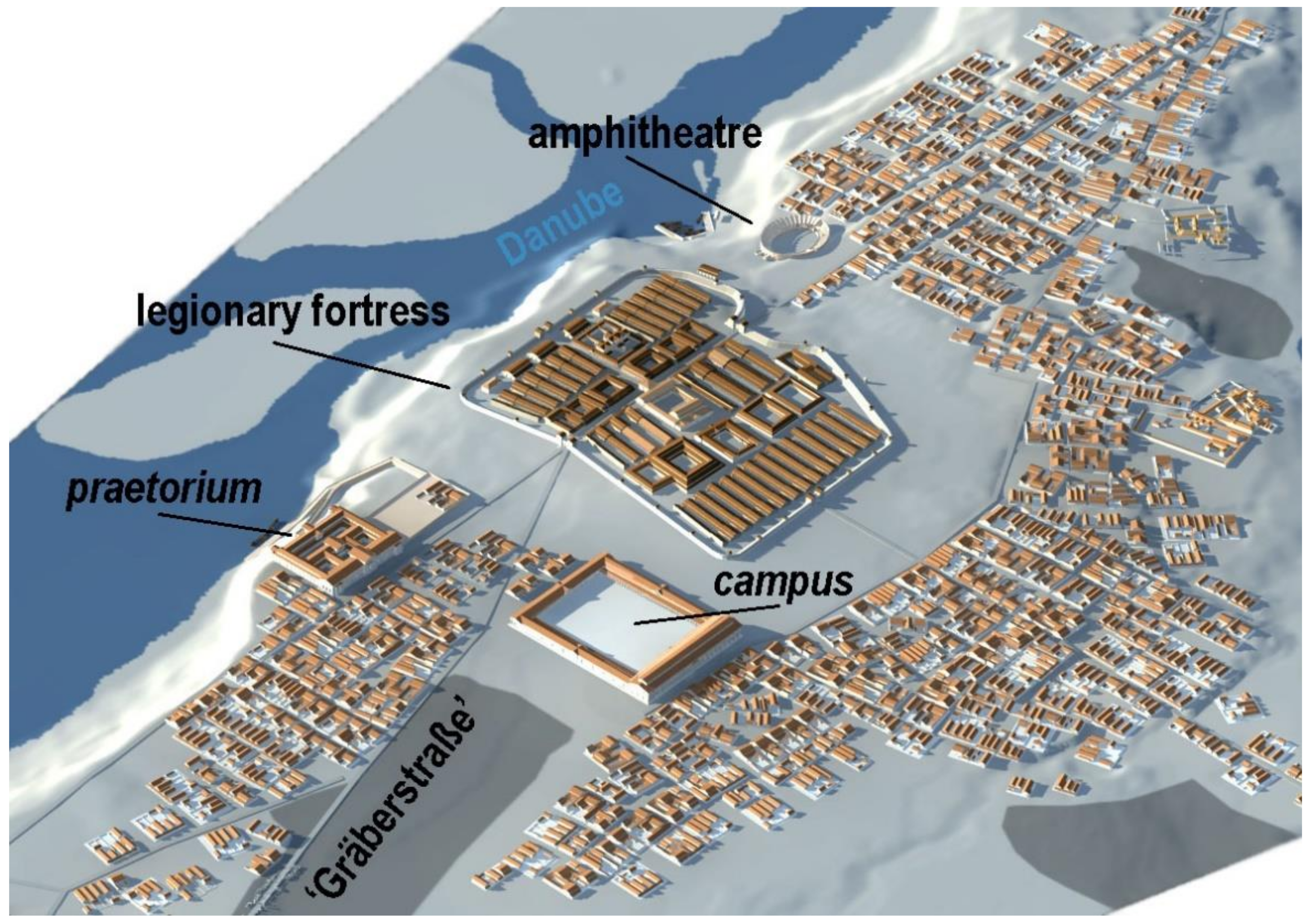
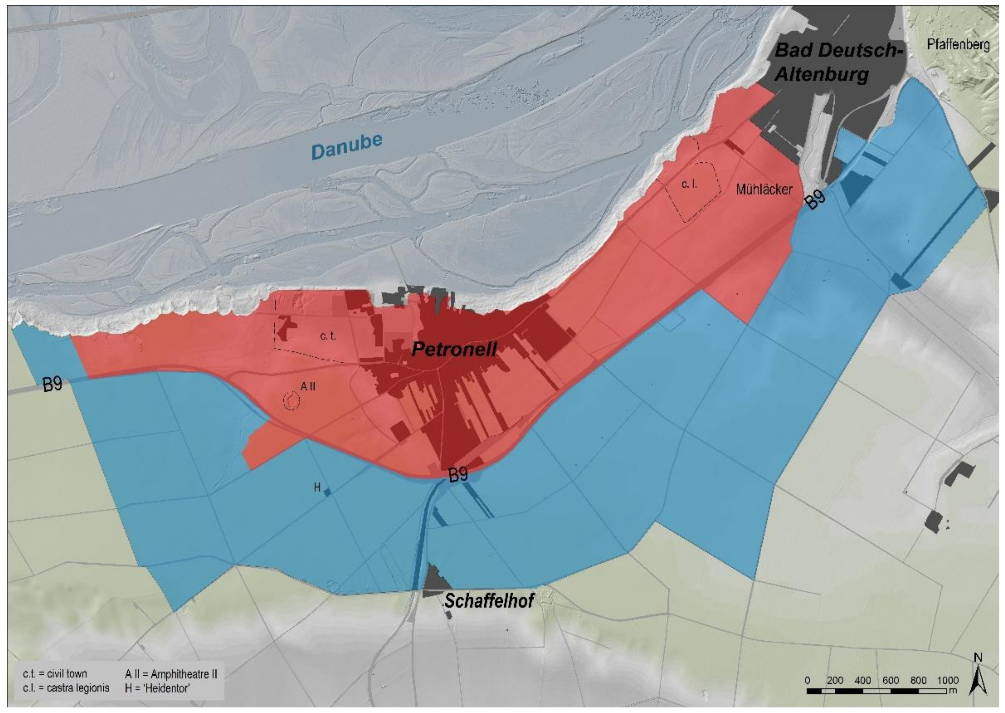
2. The Legionary Fortress at Carnuntum and Its Close Vicinity

Roman Carnuntum is located at the northern border of the Roman Empire 40 km east of modern Vienna (Austria) between the eastern edges of the Alpine range and the northwestern limits of the Carpathian Basin. Only a small part of the ancient settlement area is overbuilt by the modern villages of Petronell (in the west) and Bad Deutsch-Altenburg (in the east) (Figure 3). The Roman site is situated on a slightly undulating plain overlooking the southern bank of the river Danube marking the Roman frontier [2]. The Danube flows from west to east through the wide Vienna Basin, forming a wide flooding zone near its confluence with the river March before cutting through the Small Carpathian Mountains. A major trade route starts from the Carnuntum area following the river March to the north into the barbaricum.
At this strategic position, the Roman legio XV Apollinaris established a first permanent legionary fortress at the frontier around AD 50 [3] (Figure 4). The initial legionary fortress, an earth-and-timber construction of nearly 18 hectares in size [4], was established on a 20-meter-high flood-proof gravel terrace partly covered with Loess. The western gate, the porta principalis sinistra, was the starting point of a main road leading to the southwest as far as Aquileia (Italy). A necropolis of the 1st and 2nd century AD is expanding along the southwestern road over a distance of at least 2.4 km. The road alongside the limes ran through the fortress’ portae principales, forming an efficient connection along the Danube frontier. The shortest route to the neighboring fort of Gerulata located in the southeast in modern Rusovce (Slovakia) left the fortress through the porta decumana, the southern gate. The fortress was supported by an auxiliary fort some 700 m to the southwest, assigned to garrison an ala quingenaria, a mounted unit of 500 men [3].
During the second half of the first century AD, a civil settlement emerged in a distance of about 2.5 km to the west of the military zone. Because of the favorable demographic and economic development, Carnuntum soon became a municipium (Aelium) (AD 117–138) and finally a Roman colonia in the era of the Severan dynasty (AD 193–235). In the east of the legionary fortress, legio XV Apollinaris built a stone amphitheater already in the early 70s AD, dated by fragments of a newly discovered building inscription [5]. This military amphitheater was part of the canabae legionis, the civilian settlement that evolved around the fortress covering a total area of c. 120 ha. The canabae were nearly twice as large as the municipium nearby. Systematic photogrammetric analysis and GIS-based mapping of all aerials available provided an initial layout of the canabae [6].
After the division of the Roman province into Pannonia superior and Pannonia inferior between AD 103 and AD 107, Carnuntum became capital of Upper Pannonia [7] (pp. 349–352). Excavations west of the legionary fortress and near the nowadays steep bank of the Danube River, conducted before WWI, unearthed remnants of an extended building overlooking the Danube. The continuous erosion of the river bank heavily destroyed this building. Two votive inscriptions provided evidence for its identification as the governor’s palace (A in Figure 6), the praetorium [8] (pp. 681–683).
A large building complex—initially misinterpreted as the forum of the canabae—was excavated between 1902 and 1904 south of the praetorium (Figure 5). The extremely huge complex shows two main building phases and is currently understood as the campus (D in Figure 6), the military training ground close to the legionary fortress [9] (pp. 106–109).

3. Archaeological Heritage Management and Research in Carnuntum from the 1970s until Today

Due to the settlement expansions of the present-day villages of Petronell and Bad Deutsch-Altenburg that began in the 1970s, extensive rescue excavations became necessary. Ongoing research projects, such as the excavations in the Carnuntum legionary fortress, had to be discontinued because of construction activities. From then on, the institutions working in Carnuntum—the Austrian Archaeological Institute, the Federal Monuments Office and the Museum Carnuntinum—were very heavily burdened by these rescue excavations. At that time, the management basis, i.e., in particular our knowledge of the size and structure of Roman Carnuntum, was still comparatively very modest. Before the start of systematic aerial archaeological investigations, basically the same prospection methods were available as before in the times of the Limes Commission of the Habsburg Empire. The known settlement pattern had changed only insignificantly since the beginning of the 20th century. These time-consuming and cost-intensive rescue excavations were therefore a special challenge because there were no sufficient plans of the ancient settlement available. Surprises were therefore guaranteed: for example, the auxiliary fort located between the legionary fortress and the civil town as well as several temple precincts, buildings and tombs on the so-called Mühläcker on the eastern edge of the canabae legionis were discovered through rescue excavations [10] (pp. 34–35) (see Figure 3). On the eastern edge of Carnuntum, the sanctuary on the Pfaffenberg, which had been known for some time, was destroyed by a modern quarry (see Figure 3).
An important advance occurred when systematic aerial archaeology started from the 1980s onwards [11]. The large, unwooded areas offered ideal opportunities to use this prospection method efficiently. With the help of numerous aerial photographs, many new settlement areas could be discovered. A special focus was on the aerial photographs from the area of the military settlement (canabae), whereby here in particular the new prospection data were put into context with the old excavation results and the known epigraphic monuments [12].
During the last decade, large-scale field surveys were also carried out, initially in the surroundings of the canabae (Figure 7), but in recent years also in the southern and western suburbs of the Carnuntum civil town [13,14]. The systematically documented distribution of surface artefacts allows statements to be made about the rough chronological development and sometimes also the functional use of buildings or larger urban areas.

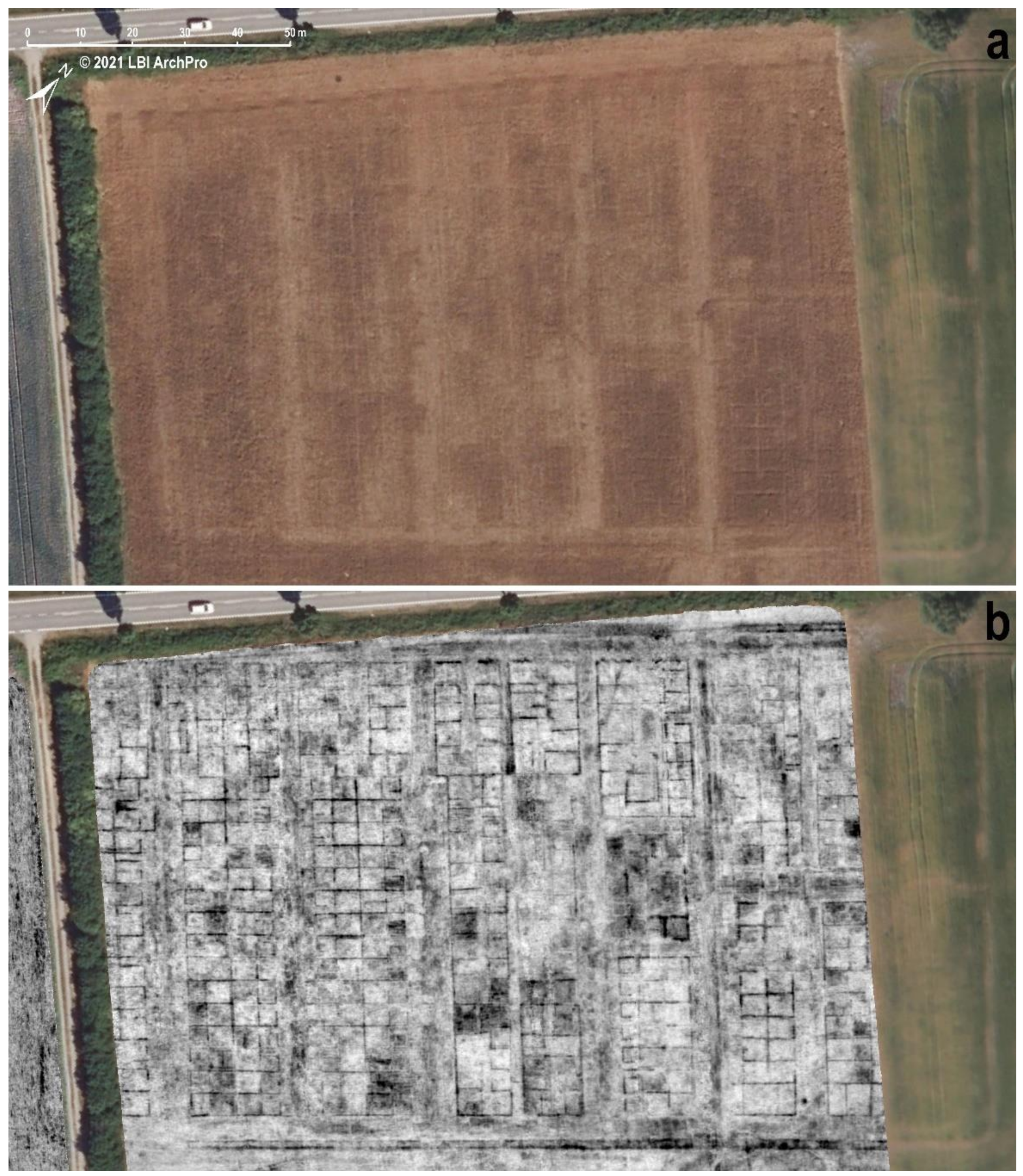
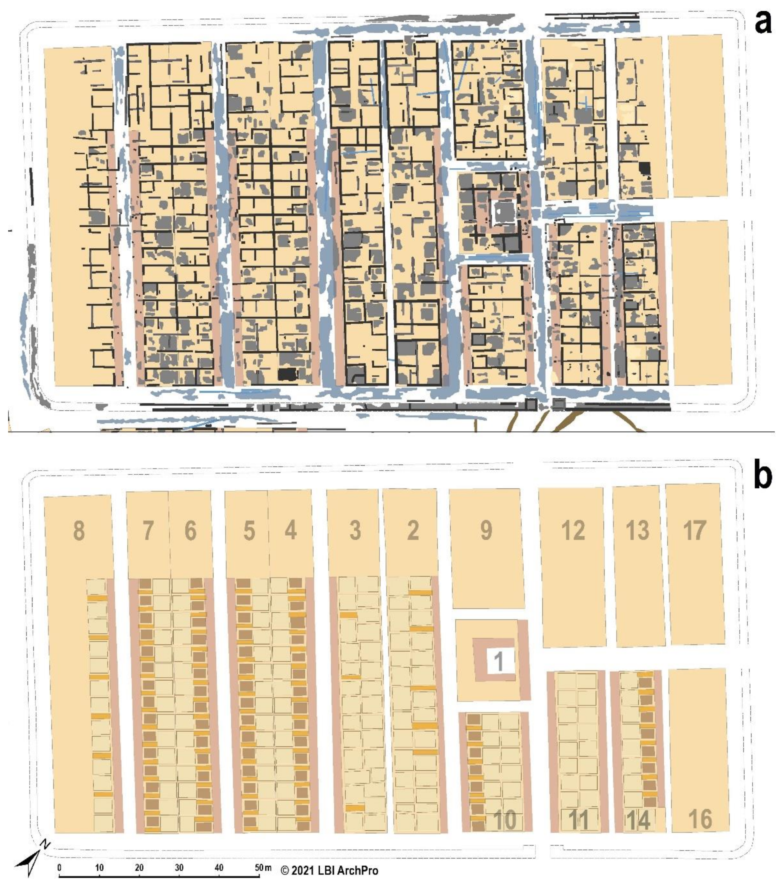
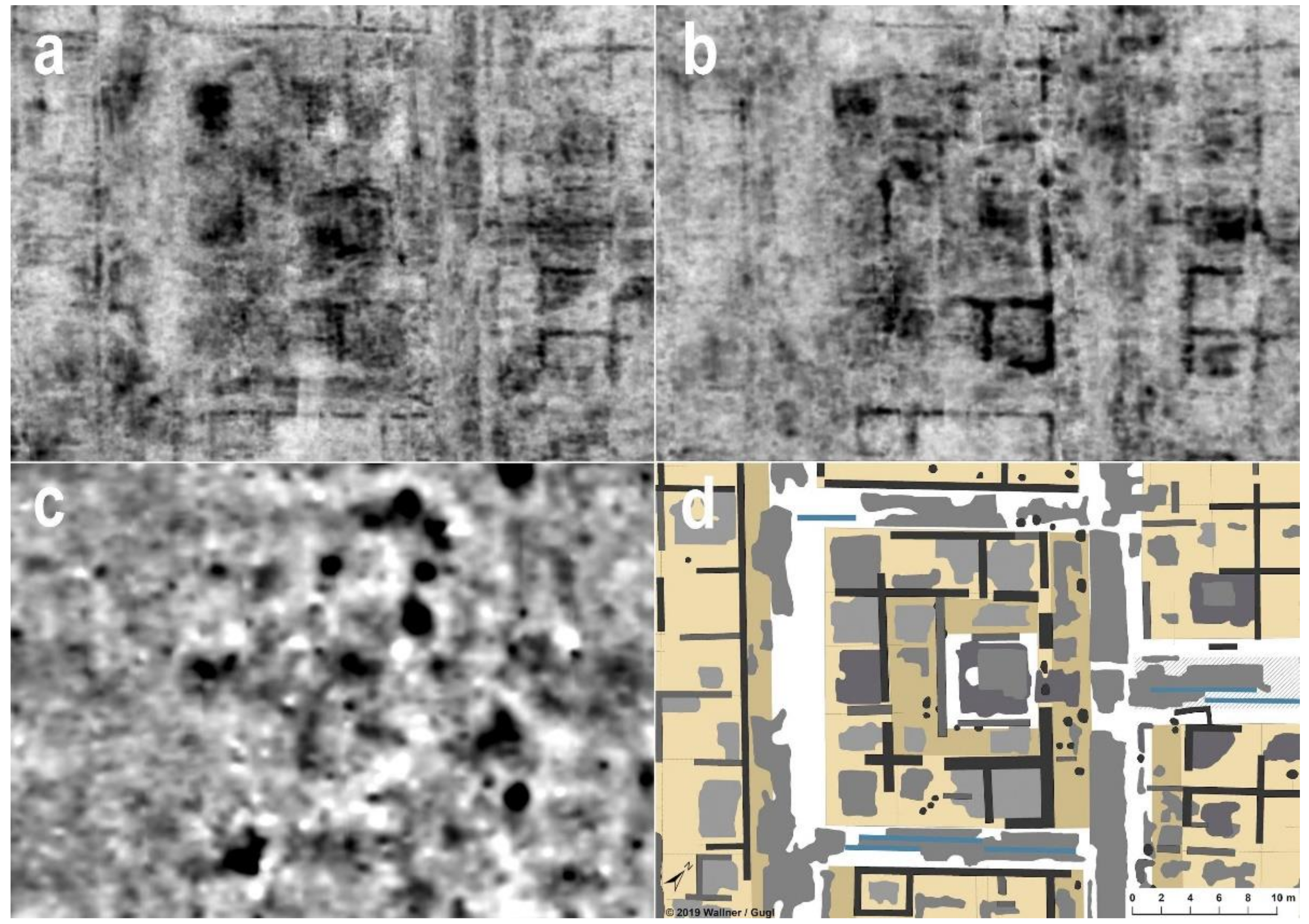
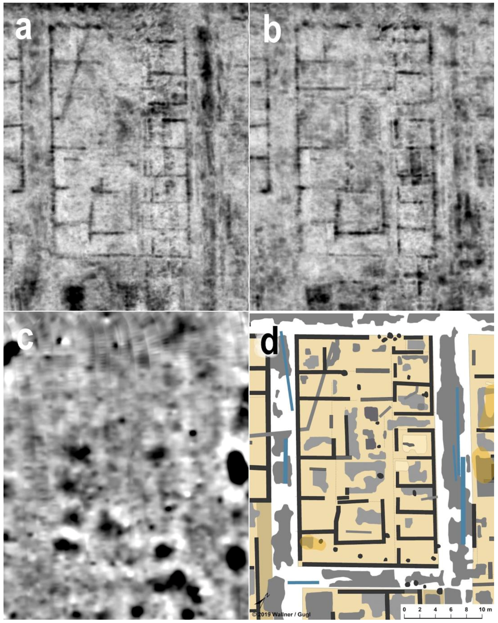
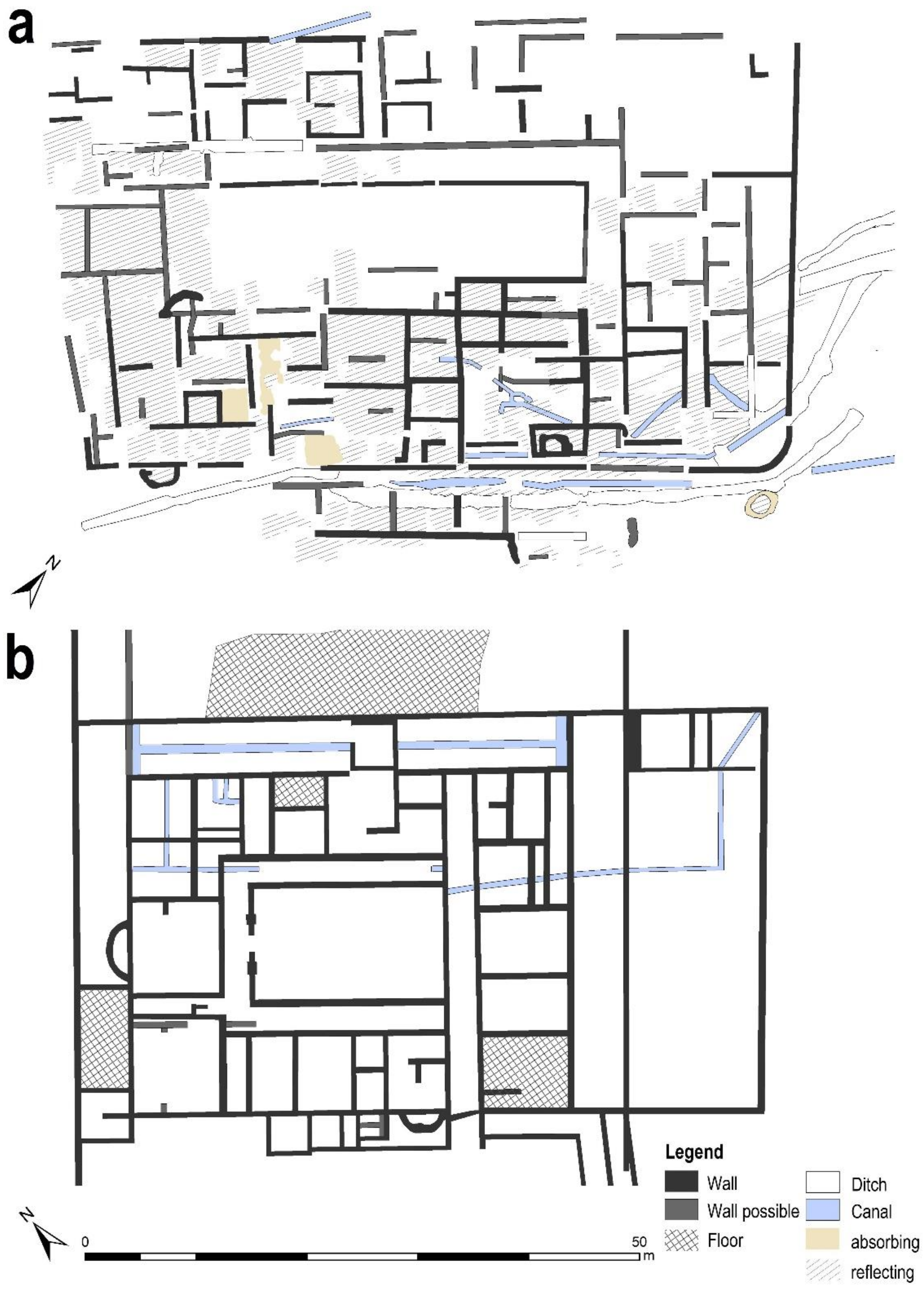
4. Large Scale Integrated Archaeological Prospection—The ‘ArchPro Carnuntum’ Project

Technological advances have opened many new possibilities for archaeological heritage management and research applying geophysical prospection methods. From 1996 to 1998, the combination of different geophysical prospection techniques made it possible to reconstruct the ground plan of the forum of the city [15] (pp. 32–50) sought for over a century. A discovery invoked further geophysical surveys covering a total area of over 1 km2 until the year 2001, running in parallel to the systematic photogrammetric analysis of all available aerials [12,16]. This initial systematic prospection approach delivered the first detailed information on the size and layout of Roman Carnuntum.
In the close vicinity of Amphitheater II, built around AD 200, the LBI ArchPro and its partners ZAMG-Archeo Prospections® and VIAS-University of Vienna, detected a building complex interpreted as ludus, a school of gladiators [17]. This discovery and the related international awareness finally invoked the large-scale non-invasive integrated ‘ArchPro Carnuntum’ project (http://lbi-archpro.org/cs/carnuntum/, accessed on 31 August 2021) funded by the Lower Austrian Provincial Government and carried out by the LBI ArchPro and its partners with the challenging goal to map the entire landscape surrounding the ancient site of Carnuntum within a time frame of three years. Novel, motorized measurement devices for rapid, high-resolution magnetometer and GPR prospection were designed and developed [18,19]. Together with the integration of automated positioning systems as well as new data processing and visualization techniques, highly efficient archaeological prospection systems [17] (Figure 4) were made available for the detailed geophysical survey of the truly vast areas (see Figure 3). A 10 km2 area in the core zone of Carnuntum was chosen to be explored with an integrated prospection approach combining airborne laser scanning, hyperspectral images and aerial photography with terrestrial magnetometry and GPR followed by joint archaeological interpretation of the digital data within a GIS environment.
The results discussed here are based on the integrated interpretation of excavations, aerial photographs, magnetometry using Förster fluxgate sensors on motorized arrays with a resolution of 0.25 m × 0.1 m and motorized MIRA (Malå Geoscience) multichannel GPR surveys with a resolution of 0.1 m × 0.08 m.

5. Discussion

5.1. The Garrison of the Governor’s Guard in Carnuntum

Despite the systematic air photo interpretation, the first evidence of another major monument between the campus and the praetorium of the governor was finally provided by the systematic GPR survey. The massive enclosing wall of the large building complex of the castra is visible in the geophysical data and new aerials (Figure 8). The approximately rectangular enclosure measures 183 m × 99 m, thus covering an area of c. 1.8 ha. It was built on even ground south to the governor’s palace about 180 m west of the legionary fortress.
Surprisingly there are no evident fortification ditches outside the wall, which are usually found at Roman forts and fortresses and should be clearly visible in the geophysics. The distance between the southern wall and the large adjacent building outside is not more than 4 m—definitely too small to assume a defensive ditch in front of the castra. The same can be stated for the northern front directly adjacent to the main road. The 1.80 m to 2.0 m wide enclosing wall consists of an inner and outer façade.
A gateway in the eastern front is clearly visible in the new aerials. From this gateway, a road leads towards a central building, the principia (1) in the interior (bottom Figure 9). In front of this central 380 m2 building there is a cross point with a north–south road. This arrangement corresponds to the layout of ordinary Roman forts which show the via praetoria and the via principalis in front of the principia, the central administrative building. However, the orientation of the castra to the east is uncommon. Due to the GPR data, only the porta principalis dextra seems to be flanked by two towers.
The principia (1) measures 21 m by 18 m and was accessible by a main entrance in the east leading towards an inner courtyard with a U-shaped porticus (Figure 10). Nearly all rooms show remains of pavements. The GPR data provides evidence to assume a 2.4 m by 2.4 m cellar inside the room in the northwestern corner. North and south of the principia (1), two buildings with comparable dimensions (30.5 m by 18 m) are visible (9 and 10) (Figure 9). The northern building (9) was constructed around an inner courtyard to be reached from the via principalis by an entrance hall (Figure 11). Due to its position in the castra and its outline, it could be interpreted as the commander’s house. The southern building (10) is tripartite with a portico at the western and eastern side.
The western part of the castra offers a regular arrangement of eight military barracks 86 m in length (Figure 9: 2–8). The officer’s quarters are situated at the northern end of the barracks, covering an area of 21.5 m × 13 m (Figure 12). The length of 64.5 m of the soldier’s accommodation wing and the 14 or 15 double chamber units of the contubernia are extraordinarily large. Barracks in auxiliary forts are generally smaller and show fewer contubernia for the accommodation of the soldiers [20] (pp. 17–115), [21] (pp. 68–71).
The barracks (2 and 3) adjacent to the principa consist of contubernia with a smaller anteroom (c. 4 m × 4.5 m) and a larger main room (4 m × 6 m). In front of the double chambers is a porch. The sizes of the contubernia are varying indicating that some contubernia might have been enlarged, whereas others received additional internal walls.
The barracks (4) to (7) further to the west are similar in their general layout, but they show two distinctive differences. These single barracks share a common rear wall, whereas we can observe an interspace of 1.5 m between the backside of the barracks (2) and (3). The anterooms and main rooms of the contubernia in the buildings (4) to (7) are approximately of similar size, measuring 4 m × 4.5 m.
On the opposite side of the castra, the interpretative mapping of the GPR measurements identified four buildings (11) to (14). At least two buildings (11 and 12) are of the same size (40.5 m × 15 m), although they definitely served different purposes according to their internal structures. Building (11) shows a taberna-like layout with a double row of single rooms, each of them accessible via a portico. The function of the buildings (12) to (14) remains unclear.

5.2. Building 15, a Part of the Governor’s Palace

South of the castra, there was another separate large building (named building 15), aligned parallel to the enclosing wall. Although the building is outside the enclosure, its relation to the gubernatorial complex seems evident, based on the coincident orientation and the small distance of less than 4 m to the castra. This 63 m × 40 m tall building with a total floor space of about 2500 m2, could expand our picture of the appearance of the administrative center as it has been suggested to be the governor’s private residential quarters [22] (p. 49).
The building consists of several building wings. The central element is an inner courtyard measuring approx. 37 m × 11 m, which is bordered on the north and east side by a 3 m wide portico (A in Figure 13). This passage continues on the east side of the courtyard as a corridor. The building wings to the north and south of the large inner courtyard have different structures. In the north, one can recognize small-scale, sometimes heated groups of rooms (B in Figure 13), many of which cannot be further interpreted. Approximately in the middle of the northern front and in the extension of the eastern line of the courtyard portico, two 10 m long corridors can be seen, which probably made the building accessible from the barracks.
The GPR images do not provide any clear information on the ground plan of the building wing to the west of the courtyard. South of the courtyard, two separate structures can be distinguished. To the southwest is an area measuring approx. 15 m × 17 m, the core of which consists of several heatable rooms (C in Figure 13). It is defined on the outside by long rectangular rooms, with a semicircular apse extending to the south of the wall. It is possible that a bath was housed here, as there are numerous indications of water pipes or channels in this southwestern wing, but also in the adjoining areas to the east.
Towards the east there are several unheated rooms, which are adjoined to the south-east of the inner courtyard by another structure of 28 m × 17 m (D in Figure 13). To the west and north, there are several heated rooms, and to the southeast there appears to be another small inner courtyard (c. 11 m × 8 m) crossed by a canal.
Numerous walls in the southwest and southeast wings have massive foundations. The rooms here appear to be more architecturally elaborate than in the eastern part of the building, where another separate structure can be reconstructed (E in Figure 13), which apparently fulfilled a different function. Its central element is a 1.5 m wide and 14 m long corridor that provides access to the adjacent unheated rooms on both sides.
The obvious contiguity to the castra singularium, the identical alignment and the extraordinary size of the building support the hypothesis that this is not a large private house but a building part of the praetorium-castra ensemble. Due to the size and layout of the building and its equipment, for example with bathing facilities, which can only be compared with the most representative peristyle villas in Pannonia [12] (p. 174, Figure 67), [23,24], [25] (pp. 77–81), [26] (pp. 107–144, Figure 6), [27] (pp. 40–41)], especially the villa of Baláca north of Lake Balaton [28], it can be assumed that the private accommodation of the governor and his family (hospitium) was located here (Figure 14).
The northeastern corner of the castra and building 15 interfere with the main Roman road coming from the southwest (see Figure 5). The detailed stratigraphic analysis of the GPR data clearly shows that the buildings were erected later than the road. This has an important chronological and structural implication to the settlement because the building process of the gubernatorial complex crucially affected the road. The ‘Gräberstraße’ (Burial road) was blocked and had to be relocated. Alternatively, travelers had to take the route following the western front of the castra to reach the ‘Limes road’. Finally, they could turn east towards the legionary fortress.
The campus is facing the castra at approximately 85 m. Its function as a military training ground has been discussed in detail elsewhere [29] (pp. 80–85), [9,30]. The first detectable building (phase 1) measured 134 m × 159 m. In contrast to the much larger phase 2-building, the earlier one is orientated parallel to the castra and building 15. Probably they have been erected simultaneously or they were in use at the same time, at least for a while. The building of phase 2 differs in orientation and size. With measurements of 175 m × 225 m, the younger campus of Carnuntum is one of the biggest buildings in the Northwestern provinces, covering an area of 3.94 ha. In the area between the campus and the castra, several constructions serving for water supply and sewage are visible in the GPR data. These channels and water conduits have been partly excavated before WWI.
South and southeast of the campus, the densely built-up housing area started to develop. This is also true for the region in the western neighborhood of the newly discovered castra. Between the campus and the road, there was open space, adjacent to the graves.

5.3. The Seat of the Provincial Governor at Carnuntum

To the north of the castra opposite the main road along the limes and overlooking the Danube on top of the 40 m cliff, we can reconstruct the palace or seat of the senatorial governor of Upper Pannonia. The position of the praetoria both in Cologne (Colonia Claudia Ara Agrippinensium) and in Budapest (Aquincum) is comparable in terms of the proximity to the Rhine or the Danube [31] (pp. 338–339). Apparently, in Germania inferior and in both Pannonian provinces, the praetoria were placed close to the riverbank. This topographical location certainly facilitated communication with the other military bases within the province, as well as with neighboring provinces along the river border. In addition, these architectural complexes were also highly visible from areas outside the empire. To a certain extent, they also manifested Rome’s claim to power vis-à-vis its neighbors on the other side of the Rhine and Danube. Regarding the connection to the waterway, a very similar situation is likely to be found at the governor’s seat of the Roman Province of Tres Daciae (Apulum), where the praetorium consularis was situated in the canabae legionis close to the Ampoi river, a tributary of the Mureș [32] (p. 109, Figure 4.13) [33,34].
Excavations in 1902 and 1903 uncovered several rooms of the building complex in Carnuntum, some of them equipped with hypocausts [8] (pp. 681–683). The identification of these rooms as belonging to the provincial praetorium is based on the specific topographic position at the river and on two votive inscriptions. The excavations of 1902 revealed an overthrown 1.52 m high votive altar close to a wall [32] (pp. 126–127 nr. 237). The inscription, written in Latin and Greek, says that L. Pomponius Protomachus, the governor (legatus Augustorum) of Upper Pannonia, dedicated this bilingual altar to Aequitas and Eudikia, respectively, the Goddess of Justice, in the years between AD 244 und AD 249. According to the excavators, the place of discovery likely coincides with the place where the governor executed acts of jurisdiction indicating that this room of the provincial praetorium should have served for administrative purposes.
In 1986, another altar was found in about 150 m of the former find spot and some 180 m away from the western rampart of the legionary fortress. The inscription mentions a group of people referred to as superiumentari et muliones, carters and mule skinners, which dedicated their votum to the goddess Epona [32] (p. 137 nr. 258), [35,36]. The dedicants are in attendance of the governor Claudius Maximus who was legatus Augusti pro praetore in Pannonia superior from AD 150 to AD 155.
However, the original extent of that architectural complex could not be revealed up to now by geophysics because the area is densely forested or so far not available for surveys. Continuous erosion of the cliff and landslides destroyed most of the architectural remains, so not much is left from the praetorium. Previously it was questioned whether this building extended further to the south, onto the other side of the ‘Limes road’ [36] (pp. 204–209). The geophysical data do not support this view.

5.4. Roman Troops at the Seat of the Provincial Governor

Roman provincial administration is complex, both in terms of the group of people involved as well as with the required buildings [31] (pp. 17–33). Soldiers formed an integral part of the officium of the governor in a Roman province. A large, elaborated administrative apparatus in our modern sense was not at the disposal of the Roman provincial organization. Therefore, soldiers fulfilled several duties, especially from the 1st century AD onwards [37] (pp. 149–169). Concerning the space needed to house these soldiers, the singulares were the most numerous group. They can be divided into infantry (pedites) and cavalry (equites). These soldiers were seconded from the various auxiliary units of the province [38,39].
Regarding the number of soldiers designated to serve at the governor’s seat, there are only two convincing written sources known so far. A wooden writing tablet from Vindolanda on Hadrian’s Wall (Britannia), dated to Flavian times, lists both the strength of the cohors I Tungrorum milliaria as well as the soldiers serving as singulares [40] (pp. 45–47 and pp. 101–102 pl. 4). From the 752 men of this unit, only 296 men were present at the garrison at Vindolanda on an 18 May (exact year unknown). Among those being absentes, 46 were singulares, probably sent to London. In two lists of the cohors XX Palmyrenorum milliaria from Dura-Europos (Syria Coele) dating to the years 219 and 222, about 60 pedites singulares are mentioned [38] (pp. 104–112), [39] (p. 287). There are other literary and epigraphic sources, which name members of the governor’s guard, but they do not offer the possibility to calculate their strength in relation to the auxiliary troops stationed in a province. Nevertheless, scholars tend to accept 5–6% of seconded soldiers from Vindolanda by using it as a general figure for establishing the strength of the governor’s guard elsewhere [41] (pp. 67–68), [31] (p. 30 nr. 160).
We know of dozens of Roman forts and legionary fortresses, especially in the frontier provinces of the Imperium Romanum. Examples of castra, determined to house soldiers in service of the provincial governor, are rare. An example of the difficulties to determine the type of the garrisoned troop at a provincial capital is Londinium (London). The garrison known as Cripplegate fort in the Northwest of Roman London measures c. 232 m × 216 m. A 1.25 m thick wall with intermediate gates and corner towers and at least one ditch protected the fort, which was integrated into the town wall at the end of the second or at the beginning of the third century AD. Parts of eight 52-meter-long barracks have been excavated [42,43], but no epigraphic evidence is available to specify the kind of troops stationed here.
At Lambaesis in eastern Algeria, we have an abundant number of inscriptions with relations to the governor of the province [7] (pp. 193–200). They concentrate around the ‘camp de l’est’, measuring 148 m × 120 m, which is approximately the same size (1.78 ha) as the castra singularium in Carnuntum. According to an inscription from the principia of the fort, the equites singulares provinciae Africae were attested here between AD 199 and AD 201, when they erected an altar dedicated to the disciplina militaris [44]. The 2.60 m thick fortification wall was a dry-stone construction with towers only confirmed at the gates. The existence of fortification ditches is uncertain [45] (pp. 201–209).
Located on the northern border of Raetia, the fully excavated 0.72 ha fort of Ellingen, was according to an inscription rebuilt by the pedites singulares in AD 182 [46,47] (pp. 166–170). Whether this unit not only renovated the fort but also manned it—with an estimated strength of 250–280 men—is uncertain, not least because Ellingen lies far from the Rhaetian provincial capital of Augsburg, where one would expect the permanent garrison of the governor’s guard.
Apart from Carnuntum, the geophysical measurements of the LBI ArchPro delivered another example of an enclosure, which probably (at least in parts) served as garrison for the governor’s guard [41,48]. It is a walled area of around 2.33 ha on the eastern edge of Virunum, the capital of the province of Noricum. Aerial photographs and GPR measurements revealed the remains of at least three barracks, which probably also housed horsemen. Some features of this camp, such as the absence of towers in the enclosure wall and the non-existence of ditches in front, correspond very well with the castra singularium of Carnuntum. Therefore, the hypothesis had already been formulated that the soldiers stationed in Virunum were attached to the governor of Noricum. Singulares and other military personnel assigned to the procurator that had no strictly military duties would have been billeted here [48] (pp. 85–89). The special features of the castra both in Virunum and in Carnuntum do not find any parallels in the forts and fortresses in the provinces. Nevertheless, the enclosed area in Carnuntum offers close connections to military installations in the capital of the Roman Empire. Therefore, military garrisons in Rome, for instance the castra nova equitum singularium [49,50] (pp. 72–83), probably served as a model for the accommodation of Roman soldiers at the seat of the governor in the frontier provinces.
Through the comparison of the number and the sizes of the soldiers’ quarters within the castra singularium in Carnuntum, it was possible to draw conclusions on the total strength of the military forces stationed at the governor’s seat and their commander structure. The existing assessment of the total strength of the singulares and other military groups in the staff of a provincial governor is in many cases based on highly speculative assumptions without a comprehensible data basis. The almost completely documented ground plan of the new fort at Carnuntum now offers further clues to estimate the size of the governor’s guard (singulares). With all precautions, the strength of the singulares of the Upper Pannonian provincial governor—who had, until the reign of Caracalla (211–217), the supreme command over three legions and the associated auxiliaries—could be estimated at a maximum of about 500 foot soldiers and about 125 cavalry men. This would correspond to the theoretical strength of a cohors quingenaria equitata [51] (pp. 97–98).

6. Conclusions

In this article, a best practice approach is presented, resulting in a detailed analysis of a newly discovered Roman fort and its close surroundings. Roman governor’s seats have only been rudimentarily explored so far. One of the main reasons for this is the enormous extent of such complexes, which are made up of different functional components. In Carnuntum, it has only been possible to localise the location of the governor’s seat in the canabae legionis using conventional archaeological methods.
Through the detailed investigation of archaeological structures, by means of non-invasive prospection methods (aerial photography, geomagnetics, ground penetrating radar), it is now possible to gain far-reaching conclusions about our cultural heritage even without physically destructive excavations. By using high-resolution motorized measuring systems, even large building complexes could be investigated in a relatively short time. The use of archaeologically nondestructive prospecting methods to explore our hidden cultural heritage is a major step forward in the planning process of preservation. In this way, precise interventions and general policies can be specifically designed for the preservation of archaeological monuments to guarantee a long-term management strategy.
From a scientific perspective, the newly discovered fort can make an important contribution to a better understanding of imperial governor’s seats and the troops stationed there. In Carnuntum, it is possible to gain an insight into the processes involved in the establishment of a governor’s seat. The castra singularium and building 15 overlap the so-called ‘Gräberstraße’, an old traffic route that started at the western gate of the legionary fortress and ran through Scarbantia (Sopron) and Savaria (Szombathely) towards Italy. With the establishment of the Upper Pannonian governor’s seat in the Trajanic period, these already fully developed settlement structures were interfered with, dragged down and turned to a new use.
The administrative center at Carnuntum is thought to have consisted of several extensive building complexes. The governor’s palace (praetorium), which was once located directly on the bank of the Danube, was destroyed by the erosive forces of the river along with all archaeological structures and can no longer be researched today. This northernmost area of the governor’s complex may have included, for example, facilities for the administration of justice, an archive and other administrative facilities, but also cult areas and even the stables and buildings for housing carriages and other vehicles. South of the Limes road, the castra singularium are situated, which housed the auxiliary and legionary troops sent to the governor from the other forts and fortresses in the province. Building 15 is also a villa-like complex that, in a province-wide comparison, could only have served as a residence for a member of the senatorial or equestrian rank. The conclusion that the private quarters of the Upper Pannonian governor were located here is therefore obvious.
Some of the quantitative considerations concerning the strength of the singulares undertaken above are, at the moment, still somewhat speculative. In any case, exciting new perspectives arise for future archaeological research in Carnuntum and in other provincial capitals, which will certainly enrich our understanding of the size, structure and appearance of Roman governor’s seats in the frontier provinces.
If we have to carry out a model reconstruction of Carnuntum again today, it would probably be better to implement this attempt only virtually. The large model completed in 2011 in the Archaeological Park is already out of date in many respects. The geophysical measurements carried out in 2011–2015 are likely to have documented the archaeological monuments hidden underground far more completely. However, only the coming decades will show how complete this documentation actually was.

Author Contributions

Conceptualization, C.G. and M.W.; methodology, C.G. and M.W.; software, A.H.; validation, C.G. and M.W.; investigation, C.G. and M.W.; writing—original draft preparation, C.G. and M.W.; writing—review and editing, C.G., M.W., A.H. and W.N.; visualization, C.G. and M.W.; funding acquisition, W.N.; C.G. and M.W. contributed equally. All authors have read and agreed to the published version of the manuscript.

Funding

By the Lower Austrian Provincial Government and carried out by the LBI ArchPro and its partners, Open Access Funding by the University of Vienna.

Institutional Review Board Statement

Not applicable.

Informed Consent Statement

Not applicable.

Data Availability Statement

https://www.7reasons.net/?page_id=37051&lang=en#2016, accessed on 31 August 2021. Figure 1: © Land Niederösterreich/Archäologischer Park Carnuntum, Bad Deutsch-Altenburg, Drawing: S. Szentes-Sinkó, according to specifications by W. Jobst. Figure 2: © 7reasons Medien GmbH. Figure 3, Figure 4, Figure 6, Figure 8, Figure 9, Figure 10, Figure 11, Figure 12, Figure 13 and Figure 14: © LBI ArchPro (Mario Wallner). Figure 5: © Michael Doneus, Christian Gugl and Nives Doneus. Figure 7: © Christian Gugl, Michaela Kronberger and Silvia Radbauer.

Acknowledgments

The Ludwig Boltzmann Institute for Archaeological Prospection and Virtual Archaeology (archpro.lbg.ac.at) is based on an international cooperation of the Ludwig Boltzmann Gesellschaft (A), Amt der Niederösterreichischen Landesregierung (A), Universität Wien (A), Technische Universität Wien (A), ZAMG—Zentralanstalt für Meteorologie und Geodynamik (A), 7reasons (A), ArcTron 3D (D), LWL—Archäologie für Westfalen (D), NIKU—Norwegian Institute for Cultural Heritage (N) and Vestfold og Telemark fylkeskommune—Kulturarv (N). LiDAR data acquisition was carried out by Airborne Technologies GmbH in the ‘ArchPro Carnuntum’ project.

Conflicts of Interest

The authors declare no conflict of interest. The funders had no role in the design of the study; in the collection, analyses, or interpretation of data; in the writing of the manuscript, or in the decision to publish the results.

References

  1. Gugl, C.; Doneus, M.; Humer, F.; Klein, M.; Paschke, V.; Weinlinger, G. Aus alten Ruinen wiedererstanden: Das neue Gesamtmodell von Carnuntum. In Erobern—Entdecken—Erleben Im Römerland Carnuntum; Bruckmüller, E., Humer, F., Eds.; MediaHistoria: Schallaburg, Austria, 2011; pp. 58–69. [Google Scholar]
  2. Humer, F. (Ed.) Carnuntum. Wiedergeborene Stadt der Kaiser; Zaberns Bildbände zur Archäologie: Darmstadt, Germany, 2014. [Google Scholar]
  3. Kandler, M. Das Reiterlager von Carnuntum und die Grabsteine im Lapidarium des Kulturhauses von Petronell-Carnuntum. In Kleine Führer zu Archäologischen Denkmälern; Neue Serie 2; Österr. Archäologisches Institut, Phoibos-Verlag: Vienna, Austria, 2008. [Google Scholar]
  4. Gugl, C.; Kastler, R. Legionslager Carnuntum. Ausgrabungen 1968–1977. In Der Römische Limes in Österreich 45; Verlag der Österreichischen Akademie der Wissenschaften: Vienna, Austria, 2007. [Google Scholar]
  5. Beutler, F. Die zwei Amphitheater von Carnuntum und deren Datierung. In Studia Epigraphica in Memoriam Géza Alföldy; Eck, W., Fehér, B., Kovács, P., Eds.; Antiquitas. Reihe 1, Abhandlungen zur alten Geschichte 61; Dr. Rudolf Habelt GmbH: Bonn, Germany, 2013; pp. 19–37. [Google Scholar]
  6. Doneus, M.; Gugl, C.; Doneus, N. Die Canabae von Carnuntum. Eine Modellstudie der Erforschung römischer Lagervorstädte. Von der Luftbildprospektion zur siedlungsarchäologischen Synthese. In Der Römische Limes in Österreich 47; Verlag der Österreichischen Akademie der Wissenschaften: Vienna, Austria, 2013. [Google Scholar]
  7. Haensch, R. Capita provinciarum. Statthaltersitze und Provinzialverwaltung in der römischen Kaiserzeit. In Kölner Forschungen 7; wbg Philipp von Zabern: Mainz, Germany, 1997. [Google Scholar]
  8. Kandler, M. Legionslager und canabae von Carnuntum, In Aufstieg und Niedergang der Römischen Welt; Temporini, H., Haase, W., Eds.; (ANRW) II 6; Walter de Gruyter & Co: Berlin, Germany; New York, NY, USA, 1977; pp. 626–700. [Google Scholar]
  9. Gugl, C.; Trumm, J. The secret of squares—Interpreting large-scale square structures at Roman legionary forts. In Limes XXII. Proceedings of the XXIIth International Congress of Roman Frontier Studies, Ruse, Bulgaria, 6–11 September 2012; Vagalinski, L.F., Sharankov, N., Eds.; National Archaeological Institute with Museum Bulgarian Academy of Sciences: Sofia, Bulgaria, 2015; pp. 103–110. [Google Scholar]
  10. Kandler, M. Carnuntum. In The Autonomous Towns of Noricum and Pannonia. Die Autonomen Städte in Noricum und Pannonien: Pannonia II; Šašel Kos, M., Scherrer, P., Eds.; Situla 42; Narodni Muzej: Ljubljana, Slovenia, 2004; pp. 11–66. [Google Scholar]
  11. Doneus, M.; Neubauer, W.; Scharrer, G. Archäologische Prospektion der Landschaft von Carnuntum. Möglichkeiten der Luftbildarchäologie. In Carnuntum Jahrbuch 2000; Verlag der österreichischen Akademie der Wissenschaften: Vienna, Austria, 2001; pp. 53–72. [Google Scholar]
  12. Doneus, M. Die Hinterlassene Landschaft: Prospektion und Interpretation in der Landschaftsarchäologie; Mitteilungen der Prähistorischen Kommission der Österreichischen Akademie der Wissenschaften; Verlag der Österreichischen Akademie der Wissenschaften: Vienna, Austria, 2013. [Google Scholar]
  13. Gugl, C.; Radbauer, S.; Kronberger, M. Die Canabae von Carnuntum II: Archäologische und GIS-analytische Auswertung der Oberflächensurveys 2009–2010. In Der Römische Limes in Österreich 48; Verlag der Österreichischen Akademie der Wissenschaften: Vienna, Austria, 2015. [Google Scholar]
  14. Gugl, C.; Radbauer, S.; Wallner, M. Archäologische Prospektion 2012–2017 in der Flur Gstettenbreite—Ein Beitrag zur Entwicklung vorstädtischer Siedlungszonen in Carnuntum. In Carnuntum Jahrbuch 2018; Verlag der österreichischen Akademie der Wissenschaften: Vienna, Austria, 2019; pp. 47–85. [Google Scholar]
  15. Neubauer, W. Kombinierte archäologische Prospektion am Beispiel der römischen Zivilstadt Carnuntum. In Carnuntum Jahrbuch 2000; Verlag der österreichischen Akademie der Wissenschaften: Vienna, Austria, 2000; pp. 27–52. [Google Scholar]
  16. Doneus, M.; Neubauer, W. Multiple survey techniques at Roman Carnuntum. Integrated prospection of the largest archaeological landscape in Austria. In In Volo Nel Passato. Aerofotografia e Cartografia Archeologica; Musson, C., Palmer, R., Campana, S., Eds.; Biblioteca del Dipartimento di Archeologia e Storia delle Arti: Siena, Italy, 2005; pp. 272–279. [Google Scholar]
  17. Neubauer, W.; Gugl, C.; Scholz, M.; Verhoeven, G.; Trinks, I.; Löcker, K.; Doneus, M.; Saey, T.; Van Meirvenne, M. The discovery of the school of gladiators at Carnuntum, Austria. Antiquity 2014, 88, 173–190. [Google Scholar] [CrossRef] [Green Version]
  18. Neubauer, W.; Wallner, M.; Gugl, C.; Löcker, K.; Vonkilch, A.; Trausmuth, T.; Nau, E.; Jansa, V.; Wilding, J.; Manojlovic, R.; et al. Zerstörungsfreie archäologische Prospektion des römischen Carnuntum—Erste Ergebnisse des Forschungsprojekts “ArchPro Carnuntum”. In Carnuntum Jahrbuch 2017; Verlag der österreichischen Akademie der Wissenschaften: Vienna, Austria, 2018; pp. 55–75. [Google Scholar] [CrossRef]
  19. Wallner, M.; Löcker, K.; Gugl, C.; Trausmuth, T.; Vonkilch, A.; Einwögerer, C.; Jansa, V.; Wilding, J.; Pollhammer, E.; Neubauer, W. The ‘Archpro Carnuntum’ project—Integrated archaeological interpretation of combined prospection data, Carnuntum (Austria). In Építés-Építészettudomány 49; Akadémiai Kiadó: Budapest, Hungary, 2021; Volume 49, pp. 77–95. [Google Scholar] [CrossRef]
  20. Davison, D.P. The Barracks of the Roman Army from the 1st to 3rd Centuries A.D: A Comparative Study of the Barracks from Fortresses, Forts and Fortlets with an Analysis of Building Types and Construction, Stabling and Garrisons; BAR International Series; B.A.R.: Oxford, UK, 1989. [Google Scholar]
  21. Burnham, B.C.; Davies, J.L. (Eds.) Roman Frontiers in Wales and the Marches; Royal Commission on the Ancient & Historical Monuments of Wales: Aberystwyth, Wales, UK, 2010.
  22. Gugl, C.; Wallner, M. Die Kaserne der Statthaltergarde in Carnuntum (Pannonia superior). In Authenticity and Experience. Governor’s Palaces of Roman Imperial Period. and the Limes. Proceedings of the International Conference, Budapest, Hungary, 5–6 November 2018; Havas, Z., Ed.; Aquincum Nostrum; Budapesti Történeti Múzeum: Budapest, Hungary, 2019; pp. 21–54. [Google Scholar]
  23. Thomas, E.B. Römische Villen in Pannonien: Beiträge zur Pannonischen Siedlungsgeschichte; Akademiai Kiadó: Budapest, Hungary, 1964. [Google Scholar]
  24. Zabehlicky, H. Zum Abschluss der Grabungen im Hauptgebäude der Villa von Bruckneudorf. In Jahreshefte des Österreichischen Archäologischen Institutes in Wien. 73; Verlag der österreichischen Akademie der Wissenschaften: Vienna, Austria, 2004; pp. 305–325. [Google Scholar]
  25. Borhy, L.; Szabó, M. Die Römer in Ungarn. In Zaberns Bildbände zur Archäologie—Sonderbände der Antiken Welt; WBG, Zabern: Darmstadt, Germany, 2014. [Google Scholar]
  26. Doneus, N.; Gugl, C.; Doneus, M.; Klammer, J. Die römische Villa von Zillingtal-Kleinberg und ihre Nachbarn in Prospektion und Landschaft. In Ein Römisches Landgut im Heutigen Zillingtal (Burgenland) und Sein Umfeld; Daim, F., Doneus, N., Eds.; Monographien Des Römisch-Germanischen Zentralmuseums: Mainz, Germany, 2018; pp. 99–182. [Google Scholar]
  27. Firnigl, A.; Nagy, M. Using colors at the Roman villas of Balaton upland. Óbuda Univ. e-Bull. 2008, 8, 39–46. [Google Scholar]
  28. Palágyi, S. Baláca als repräsentative Großvilla in Pannonien, In Bruckneudorf und Gamzigrad. Spätantike Paläste und Großvillen im Donau-Balkan-Raum; Akten des internationalen Kolloquiums in Bruckneudorf vom 15. bis 18. Oktober 2008; Von Bülow, G., Zabehlicky, H., Eds.; Sonderschriften des Österreichisches Archäologisches Institutes; Habelt: Bonn, Germany, 2011; pp. 247–258. [Google Scholar]
  29. Gugl, C. Die Carnuntiner canabae—Luftbilder und Grabungsbefunde im Vergleich, In Der Römische Limes in Österreich 47; Doneus, M., Gugl, C., Doneus, N., Eds.; Verlag der Österreichischen Akademie der Wissenschaften: Vienna, Austria, 2013; pp. 41–145. [Google Scholar]
  30. Trumm, J. Rätsel um ein Rechteck—Anmerkungen zum sogenannten forum von Vindonissa. Jahresber. Ges. Pro Vindonissa 2013, 49–63. [Google Scholar]
  31. Schäfer, F. Praetoria. Paläste zum Wohnen und Verwalten in Köln und anderen Römischen Provinzhauptstädten; Nünnerich-Asmus: Mainz, Germany, 2014. [Google Scholar]
  32. Kremer, G. Götterdarstellungen, Kult- und Weihedenkmäler aus Carnuntum. Corpus Signorum Imperii Romani Österreich Carnuntum; Carnuntum Suppliment 1; Verlag der Österreichischen Akademie der Wissenschaften: Vienna, Austria, 2012. [Google Scholar]
  33. Diaconescu, A. The towns of Roman Dacia: An overview of recent archaeological research. In Roman Dacia. The Making of a Provincial Society; Hanson, W.S., Haynes, I.P., Eds.; Supplementary Series 56; JRA: Portsmouths, RI, USA, 2004; pp. 87–142. [Google Scholar]
  34. Rusu-Bolindeţ, V. The praetorium consularis from Apulum: A symbol of official power in the province of Dacia. In Authenticity and Experience. Governor’s Palaces of Roman Imperial Period and the Limes. Proceedings of the International Conference, Budapest, Hungary, 5–6 November 2018; Havas, Z., Ed.; Aquincum Nostrum; Budapest History Museum: Budapest, Hungary, 2019; pp. 97–120. [Google Scholar]
  35. Eck, W. Superiumentari et muliones im privaten Personal eines römischen Statthalters. Z. Papyrol. Epigr. 1992, 90, 207–210. [Google Scholar]
  36. Piso, I. Eine Parallele zwischen den Praetoria der Statthalter in Carnuntum und in Apulum. In Carnuntum Jahrbuch 1993–94; Verlag der Österreichischen Akademie der Wissenschaften: Vienna, Austria, 1993; pp. 203–209. [Google Scholar]
  37. Austin, N.J.E.; Rankov, N.B. Exploratio. Military and Political Intelligence in the Roman World from the Second Punic War to the Battle of Adrianople; Routledge: London, UK; New York, NY, USA, 1995. [Google Scholar]
  38. Speidel, M.P. Guards of the Roman armies. An essay on the singulares of the provinces. In Antiquitas Reihe 1; Abhandlungen zur alten Geschichte 28; Habelt: Bonn, Germany, 1978. [Google Scholar]
  39. Haensch, R. Les singulares du gouverneur, In Corps du Chef et Gardes du Corps dans L’armée Romaine. Actes du Septième Congrès de Lyon (25–27 Octobre 2018); Wolff, C., Faure, P., Eds.; Collection Études et Recherches sur L’occident Romain; 53; CEROR: Lyon, France, 2020; pp. 279–287. [Google Scholar]
  40. Bowman, A.K. Life and Letters on the Roman Frontier: Vindolanda and Its People, 2nd ed.; British Museum Press: London, UK, 2003. [Google Scholar]
  41. Gugl, C.; Jernej, R. Das Militärlager in Virunum (Noricum). Zur Stationierung von römischen Truppen (singulares) an Statthaltersitzen. In Carnuntum Jahrbuch 2013; Verlag der Österreichischen Akademie der Wissenschaften: Vienna, Austria, 2013; pp. 51–74. [Google Scholar]
  42. Howe, E.; Lakin, D. Roman and Medieval Cripplegate, City of London. Archaeological Excavations 1992–8; MoLAS monograph 21; Museum of London Archaeology Service: London, UK, 2004. [Google Scholar]
  43. Shepherd, J. The Discovery of the Roman Fort at Cripplegate, City of London. Based upon the Records from Excavations by W. F. Grimes for the Roman and Mediaeval London; Excavation Council 1947–68; Museum of London Archaeology: London, UK, 2012. [Google Scholar]
  44. Speidel, M. The singulares of Africa and the establishment of Numidia as a Province. Hist. Z. Alte Gesch. 1973, 22, 125–127. [Google Scholar]
  45. Janon, M. Recherches à Lambèse. Antiq. Afr. 1973, 7, 193–254. [Google Scholar] [CrossRef]
  46. Dietz, K. Kastellum Sablonetum und der Ausbau des rätischen Limes unter Kaiser Commodus. In Mitteilungen der Kommission für Alte Geschichte und Epigraphik des Deutschen Archäologischen Instituts 13; Chiron: Munich, Germany, 1983; pp. 497–536. [Google Scholar]
  47. Zanier, W. Das römische Kastell Ellingen. In Limesforschungen 23; Philipp von Zabern: Mainz, Germany, 1992. [Google Scholar]
  48. Gugl, C.; Neubauer, W.; Nau, E.; Jernej, R. New evidence for a Roman military camp at Virunum (Noricum): The garrison of the governor’s guard (singulares). Caiete ARA 2015, 6, 79–90. [Google Scholar]
  49. Coulston, J.C.N. ‘Armed and belted men’: The soldiery in imperial Rome. In Ancient Rome. The Archaeology of the Eternal City; Coulston, J., Dodge, H., Eds.; Oxford University School of Archaeology Monograph 54; Oxford University School of Archaeology: Oxford, UK, 2000; pp. 76–118. [Google Scholar]
  50. Busch, A.W. Militär in Rom. Militärische und paramilitärische Einheiten im kaiserzeitlichen Stadtbild. In Palilia 20; Reichert: Wiesbaden, Germany, 2011. [Google Scholar]
  51. Hassall, M. The internal planning of Roman auxiliary forts. In Rome and Her Northern Provinces; Papers Presented to Sheppard Frere in Honour of His Retirement from the Chair of the Archaeology of the Roman Empire; Hartley, B., Wacher, J.S., Eds.; University of Oxford: Gloucester, UK, 1983; pp. 96–131. [Google Scholar]
Figure 1. Panoramic view of Carnuntum, made in the early 1990s. View from the north.
Heritage 04 00168 g001
Figure 2. Detail of the virtual model of Carnuntum, 2010/11 made by 7reasons: legionary fortress and canabae legionis with the military amphitheater, the campus and the governor’s palace (praetorium). View from the southwest.
Heritage 04 00168 g002
Figure 3. Overview of the ‘ArchPro Carnuntum’ project with modern place and field names. The blue areas were proposed for magnetometry; the red areas were proposed for GPR and magnetometry.
Heritage 04 00168 g003
Figure 4. The current state of research on the Roman settlement of Carnuntum. The civilian town in the west and the military town in the east are clearly separated. In the vicinity of the ancient city, numerous temporary military camps and farmsteads are to be found.
Heritage 04 00168 g004
Figure 5. Part of the canabae map, 2011, made by Michael Doneus, Christian Gugl and Nives Doneus: area southwest of the legionary fortress with the campus (“forum”) and the praetorium.
Heritage 04 00168 g005
Figure 6. Current archaeological interpretation of the area southwest of the legionary fortress representing the administrative district of Carnuntum consisting of A = governor’s palace (praetorium), B = garrison of the governor’s guard (castra singularium), C = building 15 and the D = military training ground (campus).
Heritage 04 00168 g006
Figure 7. Fieldwalking 2012: study areas in the south and southeast of the canabae legionis.
Heritage 04 00168 g007
Figure 8. (a) aerial photo with vegetation marks of the garrison of the governor’s guard (castra singularium), (b) the aerial photo overlayed with GPR visualization (depth slice 80–200 cm).
Heritage 04 00168 g008
Figure 9. (a) Interpretative mapping of GPR data showing detailed information on the garrison of the governor’s guard (castra singularium), (b) spatial analyses of the data set with numbering of the buildings (legend see Figure 13).
Heritage 04 00168 g009
Figure 10. Building 1 (principia). (a) GPR visualization (depth slice 50–100 cm), (b) GPR visualization (depth slice 100–150 cm), (c) magnetometry visualization (clip off value −8/12 nT), (d) archaeological interpretation (legend see Figure 13).
Heritage 04 00168 g010
Figure 11. Building 9 (commander’s house). (a) GPR visualization (depth slice 50–100 cm), (b) GPR visualization (depth slice 100–150 cm), (c) magnetometry visualization (clip off value −8/12 nT), (d) archaeological interpretation (legend see Figure 13).
Heritage 04 00168 g011
Figure 12. Building 2 and 3 (officer’s quarters). (a) GPR visualization (depth slice 50–100 cm), (b) GPR visualization (depth slice 100–150 cm), (c) magnetometry visualization (clip off value −8/12 nT), (d) archaeological interpretation (legend see Figure 13).
Heritage 04 00168 g012
Figure 13. Building 15: (a) GPR visualization (depth slice 80–200 cm) showing the different areas of building 15; (b) Interpretative mapping of all available data sets showing detailed information on the building.
Heritage 04 00168 g013
Figure 14. Ground plans of (a) building 15 in Carnuntum and the (b) villa of Baláca (County of Veszprém, Hungary).
Heritage 04 00168 g014
Publisher’s Note: MDPI stays neutral with regard to jurisdictional claims in published maps and institutional affiliations.

