Article

Enabling Citizen Engagement via Geolocated AR Interaction with a Digital Twin City

by
Xin Zhang
,
André Brown
* and
Antony Pelosi
School of Architecture, Victoria University of Wellington, Wellington 6140, New Zealand
*
Author to whom correspondence should be addressed.
Urban Sci. 2026, 10(4), 176; https://doi.org/10.3390/urbansci10040176
Submission received: 8 January 2026 / Revised: 20 February 2026 / Accepted: 13 March 2026 / Published: 24 March 2026
(This article belongs to the Special Issue Advances in Urban Planning and the Digitalization of City Management)

Abstract

This study reports on the devising and testing of the implementation and effectiveness of geolocated augmented reality (AR) as a potential means to convey urban information and elicit citizen interaction with the ability to interface with a digital twin city (DTC) environment. We have taken an open platform approach. The prospective approach is specifically chosen to test a set of technologies that could inform and actively engage citizens in matters of urban design and development. Critically, in line with the strategy of openness, the approach employs mobile technologies freely available to both citizens and city authorities. We first examine the recent DTC frameworks and the AR technologies capable of delivering the desired on-site interaction. Subsequently, we describe the structured development and testing of a prototype geolocated AR open technology implementation that could effectively integrate mutual communication with a DTC representation. In the case study, we examine the information flow paradigm between the physical and the virtual, then report on the technology’s usability. The study reveals promising performance and potential for the mobile AR system that has been developed, meeting the target expectations for the desired forms of public engagement that could be integrated with a DTC environment. If implemented, this approach has the potential to foster site-specific engagement, both digitally and physically, to enable citizens to interact with city authorities and, more broadly, to promote spatial smartness and urban intelligence.

1. Introduction

1.1. Background

Significant research attention and efforts worldwide have been directed towards making cities smarter through contemporary technology approaches to digitising a city’s physical and socio-economic infrastructure. The focus has been on aspects such as sustainability, efficiency, optimisation, collaboration and innovation in the city [1,2]. This has been supported by a range of rapidly accumulating novel digital technologies.
At the core of many discussions is the idea of the digital twin (DT). The digital twin concept refers to developing a mirrored digital counterpart to a physical system that captures information digitally throughout the physical counterpart’s life cycle [3]. A digital twin city (DTC) can, for instance, help improve a city’s resilience, sustainability, and liveability [4]. The digital twin concept has also been proposed and applied to address complex social problems [5].
Although the DTC idea and technology are still developing, early work paved the way for establishing the criteria and capability to provide geolocated architectural information [6,7,8]. In the contemporary situation, more advanced technology offers the potential that was envisaged 20 years ago in areas such as planning and simulation, monitoring, optimising and maintenance, and prediction and management [9,10,11,12].
The digital twin is increasingly being used to encapsulate not just geometric but also semantic information, relating physical objects to their associated real-time data. However, importantly, the contemporary framework offers the capability for further bi-directional interactions between the physical city and its mirrored digital counterpart [13]. Our research aims to exploit this enhanced potential.
To map and interact with the real world, the digital twin platform relies on encoding the semantic and geospatial properties of city objects and operating continuous data exchange between the physical and the virtual [14,15]. The digital twin platform utilises advanced technologies and system operations to enable this functional mechanism, for example, via GIS and UAV for surveying and mapping [11]. Other enabling technologies include BIM and CIM for modelling [10], cloud computing and Big Data for analysing and simulating [16], AR, VR and MR for interaction and visualising [17], IoT and ICT for connecting and flexibility of the interaction environment [18].
The DTC has been envisaged and developed as an intelligent virtual platform with technologies integrated for a variety of purposes, such as city management [19], disaster control [20], urban transportation [21], urban planning [22], and policy decisions [12].
However, the potential benefits envisaged for the diverse urban stakeholders tend to focus on city administrators and professionals as the leading actors. Few cities have adopted a citizen-centric strategy or an open platform approach to engage with city residents and, consequently, collaborate with them on urban issues and development. Behrouz et al. [23] are authors of a notable exception.
Consequently, the current situation is rather disappointing, as the public tends to have minimal exposure to the DTC framework and, particularly, to interactive engagement with the DTC. Charitonidou [24] noted in 2022 that “the digital twin’s function often neglect the importance of social interactions, cooperation, … and essential non-material qualities”. Instead, current DTC practices tend to focus on machine-oriented data and have lost sight of human-derived data as the critical enabler that can aid in achieving more comprehensive smart city goals [25,26]. Therefore, the DTC has great potential to be a better-exploited tool in decision-making related to social, political, cultural and economic issues and make a significant contribution as a sophisticated socio-technical system rather than being limited to being seen as a comprehensive technical aid [24,25,27].

1.2. Scope and Objectives

Although the long-term ambition of this research is to enable meaningful, bi-directional citizen engagement within a digital twin city (DTC) framework, achieving this vision requires a series of incremental phases. Given that, to date, no established geolocated AR approach has been used or developed specifically to link citizens directly with a DTC, this study deliberately focuses on an initial and foundational phase. In short, the research here addresses the question: is there an open platform technological approach that could furnish a ‘citizen layer’ with geolocated information and citizen feedback in a form that could be usefully integrated with a digital city twin?
In accordance with this, this paper is focused on the technical exploration and feasibility assessment of a geolocated AR approach as an enabling interface between a physical urban space and a digital twin environment. Rather than claiming comprehensive behavioural or societal impact, this study positions its findings as exploratory and illustrative and is intended to establish a practical technical basis upon which more extensive empirical and participatory research can be built.
Within this scope, the study addresses the following aims and research questions:
  • Technology Capability Survey Aim: To establish what the opportunities are for recent technology in AR to be configured to implement a geolocated AR system that is capable of delivering, visualising and recording urban information and data whilst the citizen user is in a physical city environment. By connecting the data collected to a locally abstracted section of an actual DTC model, it shows that the data can be integrated with the DTC in a two-way flow of information.
  • System Analysis Question: To analyse what technical workflows and system architectures are the most applicable and effective for a typical citizen user to transmit geo-referenced information to a DTC model dataset using a geolocated AR approach.
  • Usability Evaluation Question: To what extent does the prototyped geolocated AR system demonstrate an acceptable technical performance and indicative feasibility that is sufficient to support its potential use as a citizen-interactive interface that could communicate with a DTC environment?
By addressing these questions, this paper aims to explore the pragmatic and practical aspects of geolocated AR as a foundational enabling technology for future citizen–DTC interaction. With this foundation established, broader social impact, participatory effectiveness, and large-scale deployment are subjects for subsequent phases of research.

2. Opportunities for Citizen Engagement

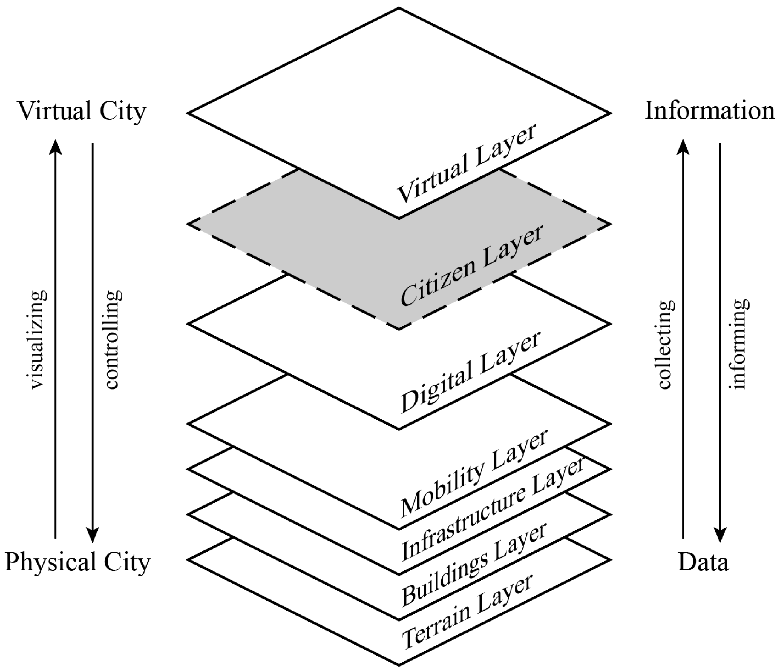
Several digital twin cities have been studied and reported on by researchers, such as ‘Digital Urban European Twins’ [28], ‘Virtual Singapore’ [29], ‘Virtual Zurich’ [30] and ‘Digital Twin of Hervanta, Tampere’ [31]. Each implementation has significant differences, and there is no unified picture of what a DTC is and what capabilities it should have. However, scholars have aimed to propose how a DTC should be composed. White et al. [12] suggested that a DTC model should ideally build on six layers of information: terrain, buildings, infrastructure, mobility, and digital layers, with the virtual layer (or digital twin layer) on top. The digital layer collects data generated by the four underlying layers in the city and passes it to the virtual layer, where simulation, prediction, monitoring, and optimisation can take place. Then that information flows back to other layers in the physical city to guide the execution of intended actions that are related to city services. This bi-directional information exchange is supported by an ICT system throughout the life cycle of city change. Integrating IoT sensors into the physical environment is a common feature. Several mobile or stationary devices, objects, and assets throughout the city can be connected and their data mapped from the physical to the virtual within a digital twin framework. This machine-oriented spatiotemporal data can be processed and visualised as a virtual representation to support decision-making or intervention [32].

2.1. The Citizen Layer

However, as mentioned before, the transaction between citizens and the DTC system has been underdeveloped. Consequently, we suggest incorporating a layer of citizen-generated information into the DTC framework to enable information provision, feedback reporting, and mutual interaction among citizens, the digital system, and, in turn, all authorities/stakeholders (see Figure 1). To enable this, a user-friendly, open-access connection channel should be provided to support human-derived data transactions and information awareness for all, i.e., citizens, stakeholders, decision makers, experts, and administrators [33].
Although emerging technologies, such as augmented reality (AR), have been integrated into digital twin workflows to create immersive visual experiences in some cases [34], there remains limited exploration of the active connection of geographical space within the digital twin paradigm [35], particularly at the citizen level. Researchers report that the significant potential to model, visualise, and transmit spatiotemporal information, thereby changing the patterns of spatial cognition and social interaction, has been underdeveloped and underexploited. The situation could be significantly addressed by leveraging the substantial benefits of intuitiveness, efficiency, immersion, and interactivity offered by AR technology [36,37]. In addition, many studies have shown that a collaborative management platform for urban issues and city management can provide practical and powerful means to involve diverse stakeholders productively [19,38,39].

2.2. The Proposed Geolocated AR System

In response to the context described above, this study adopts citizen-centric principles. It explores how an “Internet of People” can be aligned with the digital twin city (DTC) idea to enhance public interactions and enable smarter, more responsible urban development. However, considering the complexity of cities as interconnected social ecosystems, it is appropriate to define the scope of our attention. Our work focuses explicitly on the technology-enabling perspective, investigating how public interaction can be facilitated by the latest immersive technology innovations and the consequent potential opportunities to improve public awareness and engagement with the digital twin concept.
In this study, the concept of a “citizen layer” within a DTC is tested through a geolocated AR–supported interface that would link citizens and authorities within an urban decision-making context. Live engagement with a city model is not possible in this testing phase and the research reported here operates with a locally abstracted section of an actual DTC dataset. The concept of “engagement” acts at a functional level and refers to the ability of citizens to access, perceive, and respond to location-specific urban information while being physically present on site. In reverse, this system would be intended to support the reverse workflow, in which citizens could also submit location-specific feedback, comments, or proposals through this interface. Such citizen-derived inputs could then be transmitted back to the DTC environment and made available to decision makers and stakeholders as, importantly, contextualised, geo-referenced data.
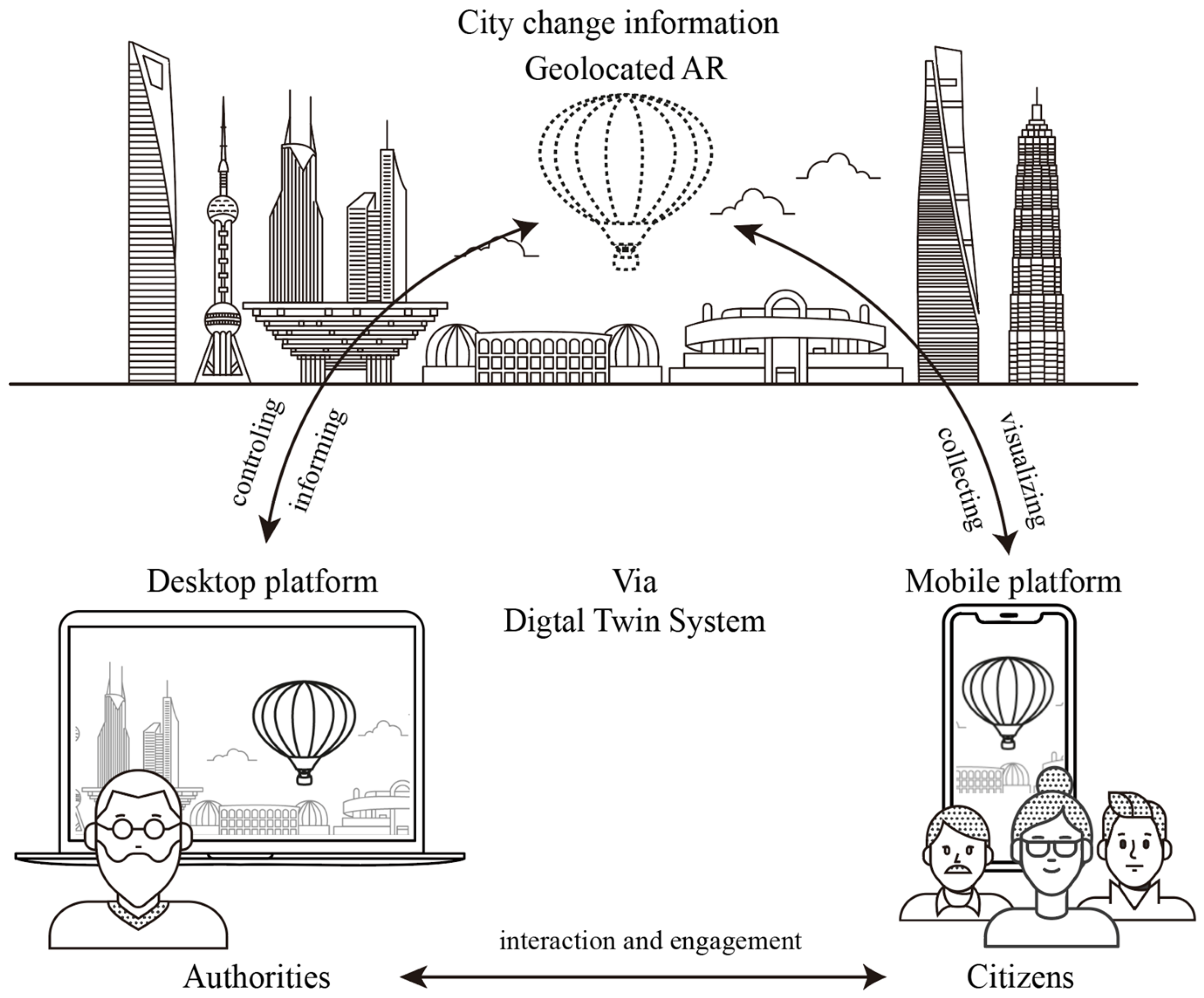
To be specific, within the proposed system, authorities and professionals act as information providers by publishing geo-referenced digital twin content, such as the core model data augmented with design proposals, proposed spatial interventions, or regulatory information. This would be made available through a geolocated AR interface. Citizens are linked to this DTC environment by receiving and exploring urban information in situ, using mobile devices to visualise digital twin data that is anchored to the physical environment; this interaction is implemented and evaluated in the current prototype reported here. The system is further conceived to support communication between citizens, authorities, and experts, enabling citizens to provide location-specific feedback or proposals via the same geolocated AR medium. Such workflows are ideally bi-directional, allowing human-derived data to be collected and integrated into the DTC framework to support urban decision-making, see Figure 2. Our prototype tests the foundational aspect of the geolocated delivery of information to a citizen user (such as a design proposal) on site and the transmission of their feedback (such as comments, objections or preferences), which would be locked to the appropriate location in an abstracted version of the digital twin.

3. Methodology

This study adopted a mixed-methods research design combining a literature and technical review with prototype-based experimentation and usability evaluation to investigate how digital technologies, specifically augmented reality (AR), can enhance public awareness and interaction within an urban digital twin environment. The methodology is structured to integrate conceptual analysis with technical implementation and user-centred assessment, ensuring both analytical rigour and practical relevance. The stages are outlined below.

3.1. Literature and Technical Review

A focused literature and technical review was conducted to establish the conceptual and technological foundation of the study. The academic literature was reviewed to examine recent developments in the digital twin city (DTC) frameworks, immersive urban visualisation, and public participation enabled by AR technologies. Particular attention was paid to studies addressing the role of digital twins in urban governance, citizen engagement, and sustainability-oriented decision-making.
In parallel, a technical review of contemporary AR technologies and development environments was undertaken. This included an assessment of the following:
  • Geolocation-based AR systems;
  • Mobile AR software development kits (SDKs);
  • Spatial data integration workflows;
  • Hardware capabilities of consumer mobile devices.
The review aimed to identify the critical technical capabilities required for deploying AR-based interfaces within urban digital twin contexts, including spatial accuracy, real-time rendering, scalability, and accessibility for non-expert users. The findings informed the selection of development tools and the overall system architecture used in the prototype phase.

3.2. Prototype Development and Experimental Implementation

Following the review phase, prototype experiments were conducted to explore the practical implementation of a Geolocation-based AR system linked to the digital twin city. Current and widely adopted AR development tools were utilised to ensure technical feasibility and reproducibility.
The prototype development process involved:
  • Integrating geospatial data from the digital twin environment into an AR platform;
  • Implementing location-aware AR visualisation functions on mobile devices;
  • Testing system workflows, including data loading, spatial alignment, and real-time interaction;
  • Iteratively refining the prototype based on technical performance and usability considerations.
This experimental phase functioned as a research-through-design process, allowing the authors to evaluate the suitability of different development approaches and to identify constraints related to accuracy, latency, user interaction, and system stability. The outcomes of the prototype experiments were analysed to validate an appropriate technical approach for enabling public interaction with digital twin data in real urban settings.

3.3. Usability Evaluation

To assess the feasibility and usability of the technical basis of this proposed AR system, a mixed-method evaluation framework was adopted, combining IsoMetrics and user engagement tools. The structured evaluation was divided into two parts. First, IsoMetrics were used to obtain an expert review that assessed the usability from a developer’s perspective; IsoMetricsS (short version 2.01e) was employed for this (see Section 5.1). Then, a user engagement study was conducted using the user engagement scale (UES version 11, 2023).
IsoMetrics is a recognised usability assessment framework derived in response to meeting the standards set in ISO 9241-10 [40] and is well-suited for evaluating interactive digital systems. This evaluation comprised both formative and summative assessments:
  • A formative evaluation was used during the prototype refinement process to identify usability issues that were related to navigation, clarity of information, and interaction feedback.
  • A summative evaluation was conducted to assess the overall system usability, feasibility, and performance once the prototype had reached a stable configuration.
The user engagement scale assesses the quality of user experience characterised by the depth of an actor’s cognitive, emotional, and behavioural investment when interacting with a digital system. It assesses the ability to attract and sustain user participation in digital interactive environments. The six key dimensions assessed included:
  • Novelty;
  • Aesthetics;
  • Focused attention;
  • Felt involvement;
  • Perceived usability;
  • Endurability.
The evaluation results were analysed to determine how to construct the AR system most effectively and to estimate how well it would engage with general users, which supports the study’s overarching objective of improving public awareness and interaction within urban digital twin environments. Insights from the usability assessment were also used to identify design implications and future development opportunities.

4. Prototype Development and Testing

4.1. Fundamental Requirements of the Potential AR System

Previous research on AR in participatory urban planning suggests that AR can enhance spatial understanding, particularly for non-experts, by enabling in situ visualisation of proposed interventions and making abstract planning information more tangible and experiential [35,37]. AR has been shown to increase engagement levels and facilitate more informed discussions during public consultations. However, studies identify key barriers, including spatial misalignment, device variability, digital literacy gaps, unequal access to technology, and ethical concerns such as data privacy and representational bias. These findings indicate that while AR holds strong potential for supporting public engagement, its effectiveness depends not only on technical capability but also on usability, accessibility, and careful socio-technical integration.
For AR interaction to be location-aware, the mobile device the user is holding must accurately identify the current physical location. Marker-based augmented reality (AR) is one way to do this. Marker-based AR overlays digital information onto the real world using specific graphical items, known as markers, placed in the environment. Compared with marker-based AR, marker-less AR relies on natural features such as tracking solutions to trigger and locate the AR experience, rather than predefined fiducial markers such as images, barcodes, or QR codes [41,42].
An AR system can be substantially enhanced by simultaneous location and mapping (SLAM) technology, which understands and reconstructs the real environment by continuously calculating the position and orientation from key points in a physical three-dimensional environment [43]. This technology enables the connection of all kinds of sensors to modern mobile devices. It contributes to a more advanced location-based AR experience that leverages features such as a depth camera, GPS, compass, and accelerometer [44].
Geolocated AR is explicitly tied to the user’s real-time geographic location to enable the recognition, tracking, and blending of digital content. It also allows augmentations to be designed and attached to specific preset geolocations. SLAM technology can unlock valuable potential and creative features to enable higher-level spatial intelligence and an innovative user experience, which makes it a point of interest in this study.
The particular points that indicated how the approach using marker-less location and SLAM enhancement could be effective were as follows:
  • A Generally Good Level of Accuracy and Stability: SLAM and GPS enable the user to track the position and orientation with a relatively high level of accuracy in the real world, and their straightforward mode of operation of identifying the physical coordinate to initiate the AR makes the location remain stable with minimal interruption, even within a complex and dynamic urban environment.
  • Wide Accessibility and Engagement: With modern mobile devices now equipped with essential sensors, geo-supported services have been highly accessible to most users for interacting with their environment. Major technology firms such as Apple and Google are continuously developing AR tools and solutions, broadening access and engagement across the public sector.
  • Enhanced Interactivity and Communication: The ICT development of 5G/6G features in this networking between users and the information that can be achieved effectively in real-time. Their urban information awareness and storytelling can be facilitated and personalised with immersive experiences for specific spatial targets in the immediate city surroundings.
  • Realistic Scalability and Registration: With scalability to large areas offering a real 1:1 virtual object model within a city or even an entire country, the technology registers with global unified coordinates and with a trajectory in the physical world, which bridges the gap between virtual and physical reality and further creates a better cognitive experience in the physical world.
The integration of accurate geolocated AR to enable an accurate connection to the digital twin city framework represents a significant advancement in encapsulating not only geometric and visual information but also semantic and behavioural information and in linking physical city elements with real-time data, personal insights, and community feedback. This multidimensional representation enhances the interpretability and relevance of urban data for a broader public user base, turning otherwise abstract city simulations into accessible, experiential interfaces for the citizen.

4.2. AR Technology Components

In 2023, we surveyed the most popular AR software development kits (SDKs) and AR development platforms that were developed over the past few years to establish their key features [45]. From our previous survey, Google’s ARCore (Google LLC, Mountain View, CA, USA) and its Google Geospatial Creator API were highlighted for their comprehensive features that enable the creation of location-based AR experiences [46,47]. Although initially aimed at Android devices, these technologies can also be developed and configured for Apple’s platform and devices [48]. It is associated with Google Maps (Google LLC, Mountain View, CA, USA) data and supported by the majority of smart devices, ensuring a diverse testing audience.
On the other hand, each AR development platform has distinct features within its designated ecosystem; its specialisation emphasises the specific platform, development needs, target audience, and user experience. We have investigated the platforms and made a structured comparison of the features and capabilities, and the details refer to our previous work [45]. Their main features are summarised and compared in Table 1. The Unity (Unity Technologies, San Francisco, CA, USA) game engine supports the most comprehensive range of operating systems, SDKs and APIs, making it especially suitable for developing lightweight mobile projects with real-time 2D and 3D experiences. Adobe Aero (Adobe Inc., San José, CA, USA) has proven to be the most intuitive and user-friendly all-in-one AR authoring and viewing platform, requiring no coding and minimal technical expertise. Therefore, to foster the widest inclusivity for a multitude of users in urban AR experiences, we have used combinations of Google ARCore and the Geospatial Creator API as primary digital tools and both Unity and Adobe Aero as platforms for comparison to develop the geolocated AR system in this study.

4.3. Objective

The objective of the prototype development and testing process described here is to provide technical evidence to guide the development of a geolocated AR system aimed at enhancing information-informed workflows and intended as a basis for improving public spatial awareness and fostering a more comprehensive connection within digital twin city representations.
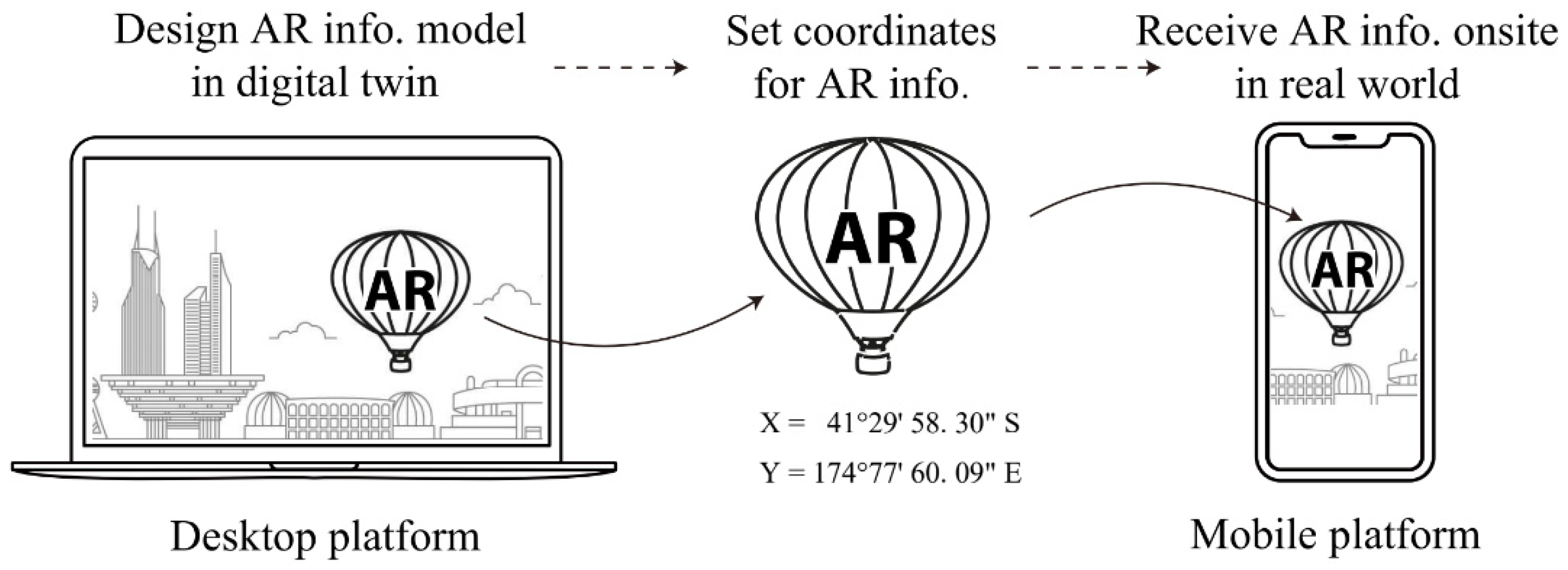
Our fundamental location performance requirement for prototyping the geolocated AR system is shown in Figure 3. To test the proposed technology combinations, we use relatively simple virtual 3D building models to illustrate how citizens might respond to urban issues by interacting on-site via an AR-assisted approach. Subsequently, we describe several developed case studies to test the system’s capacity for information transmission and public interaction. This strategic choice of technology combination allows us to prioritise the core functionality and integration of the geolocation feature first, then to focus on information flows subsequently.

4.4. Process

To develop a geolocated AR system, hardware and software are applied to create an AR application for both Android and iOS. The chosen technologies are not limited to specific devices; other combinations meeting the required specifications can also be suitable. The hardware and software tools used in the experiment are shown in Table 2.
The process began by creating AR applications on the desktop before being transferred to a mobile platform. Huawei and iPhone, respectively, were the devices hosting the Android and iOS target platforms. Cesium provided high-precision full-scale 3D global geospatial data through its Map Tiles API, which partners with Google Maps and Geospatial Creator to support a photorealistic 3D city digital model. ARCore is connected with the Geospatial Creator API for the AR programming process. ARKit was used as the plugin to enable ARCore on iOS; to do this, one must build the application with iOS SDK version 15.0 or higher [48].

4.4.1. Unity

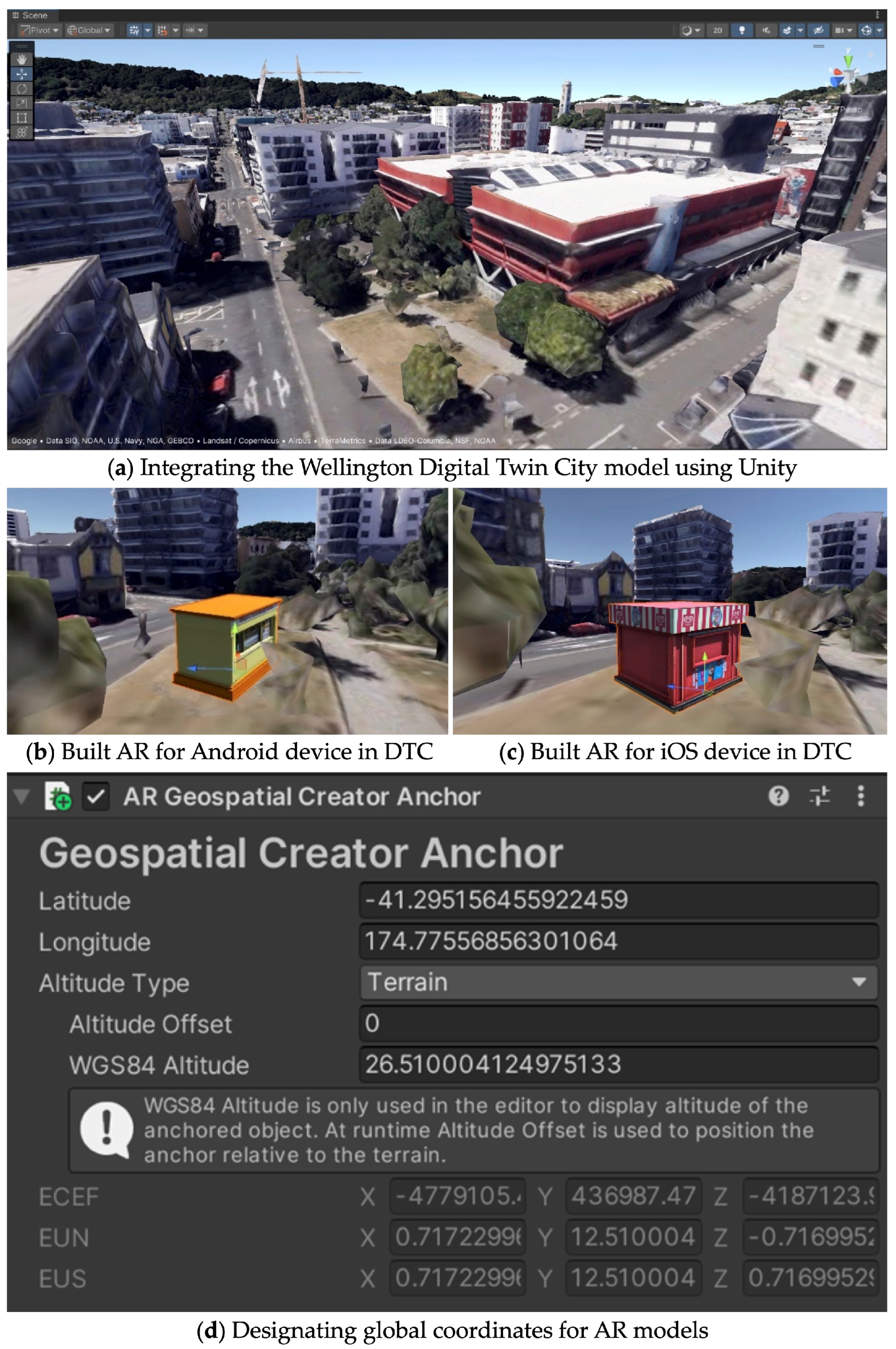
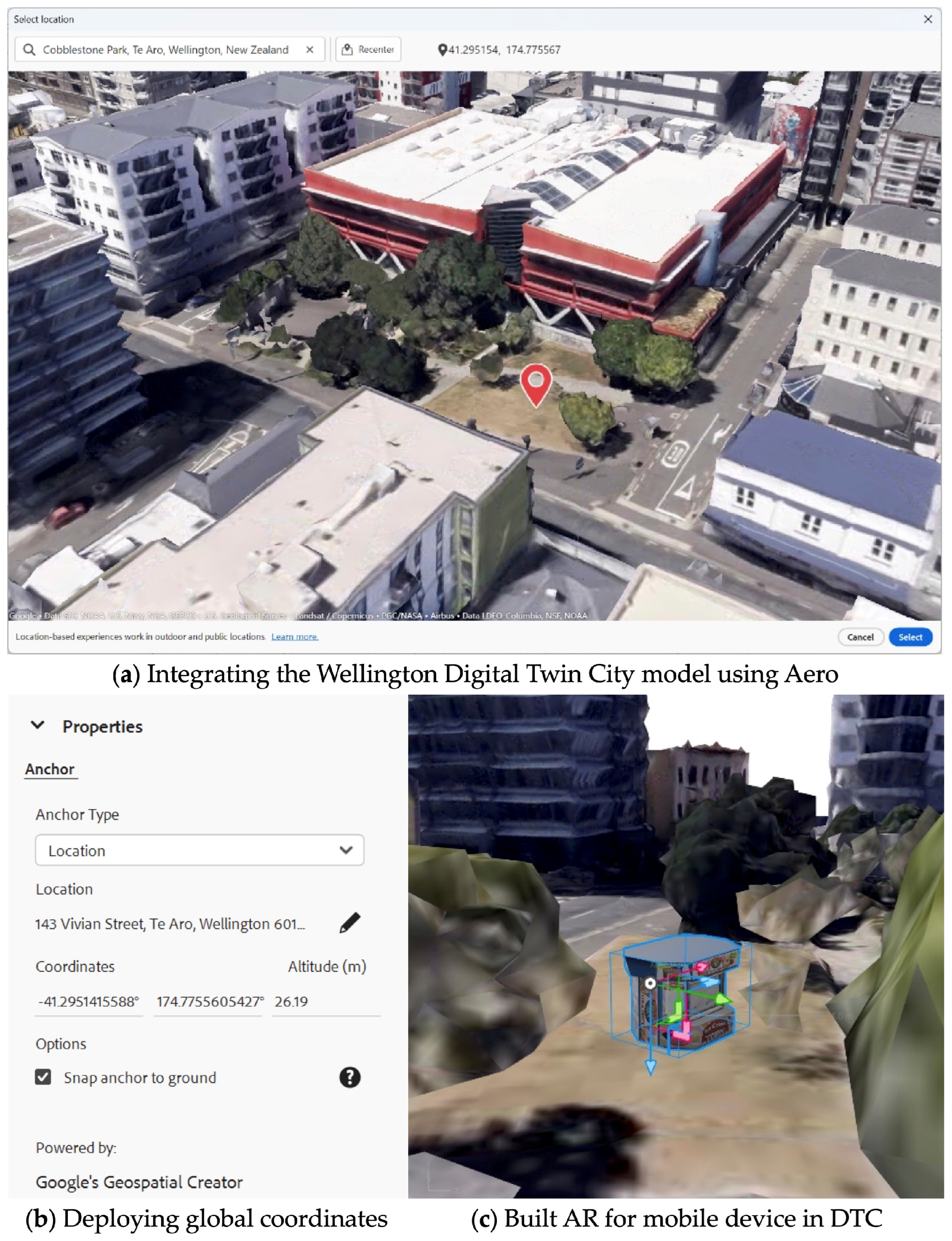
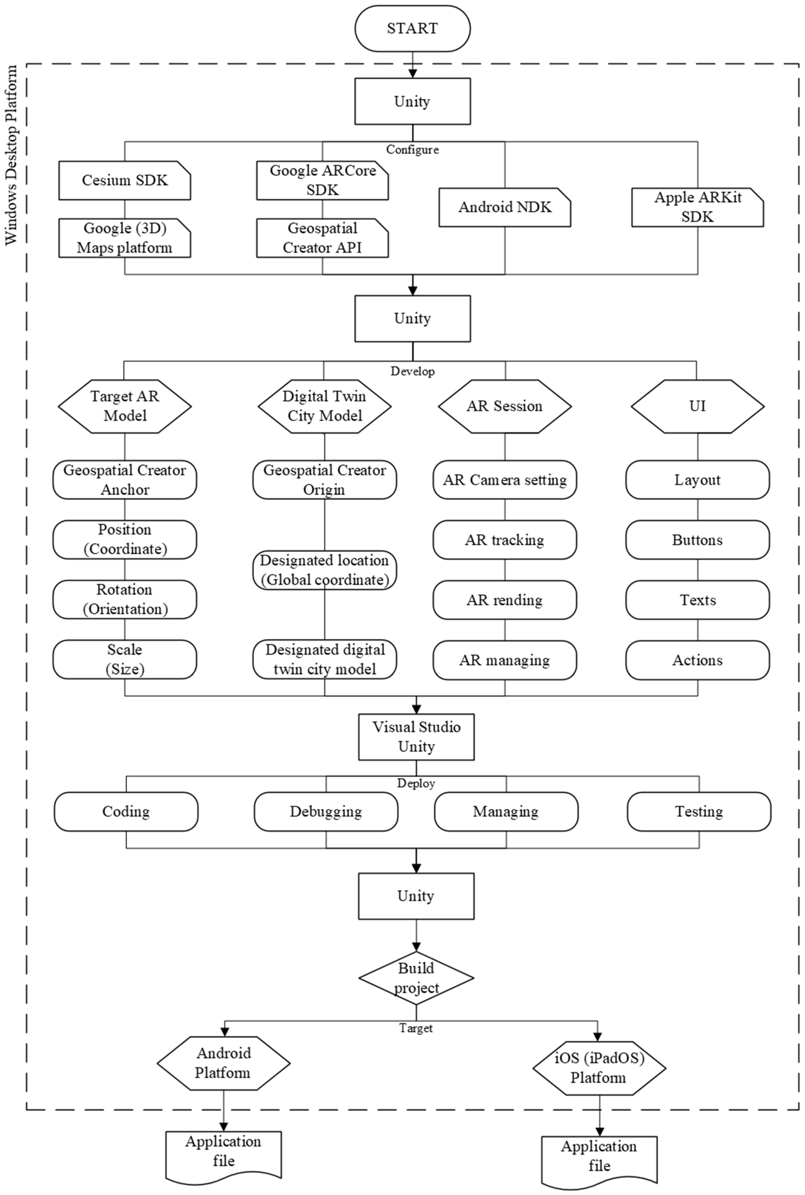
Developing with Unity on the desktop platform begins by enabling Google Maps titles and the ARCore APIs, then by creating a 3D URP (universal render pipeline) geospatial project that is supported by essential SDKs, including Cesium, ARCore, ARKit, and the Android NDK. Core components such as AR sessions, UI, and geospatial managers are configured, and a digital twin city model is integrated using Cesium with Google. The Geospatial Creator Origin is set by entering the global coordinate (latitude, longitude, and height) to display the designated location of the 3D city model. The test site uses Cobblestone Park lawn in Wellington City as the implementation venue, so its coordinates are set to “ latitude: −41.29515, longitude: 174.77556, altitude: terrain type by WGS84 altitude” as seen in Figure 4.
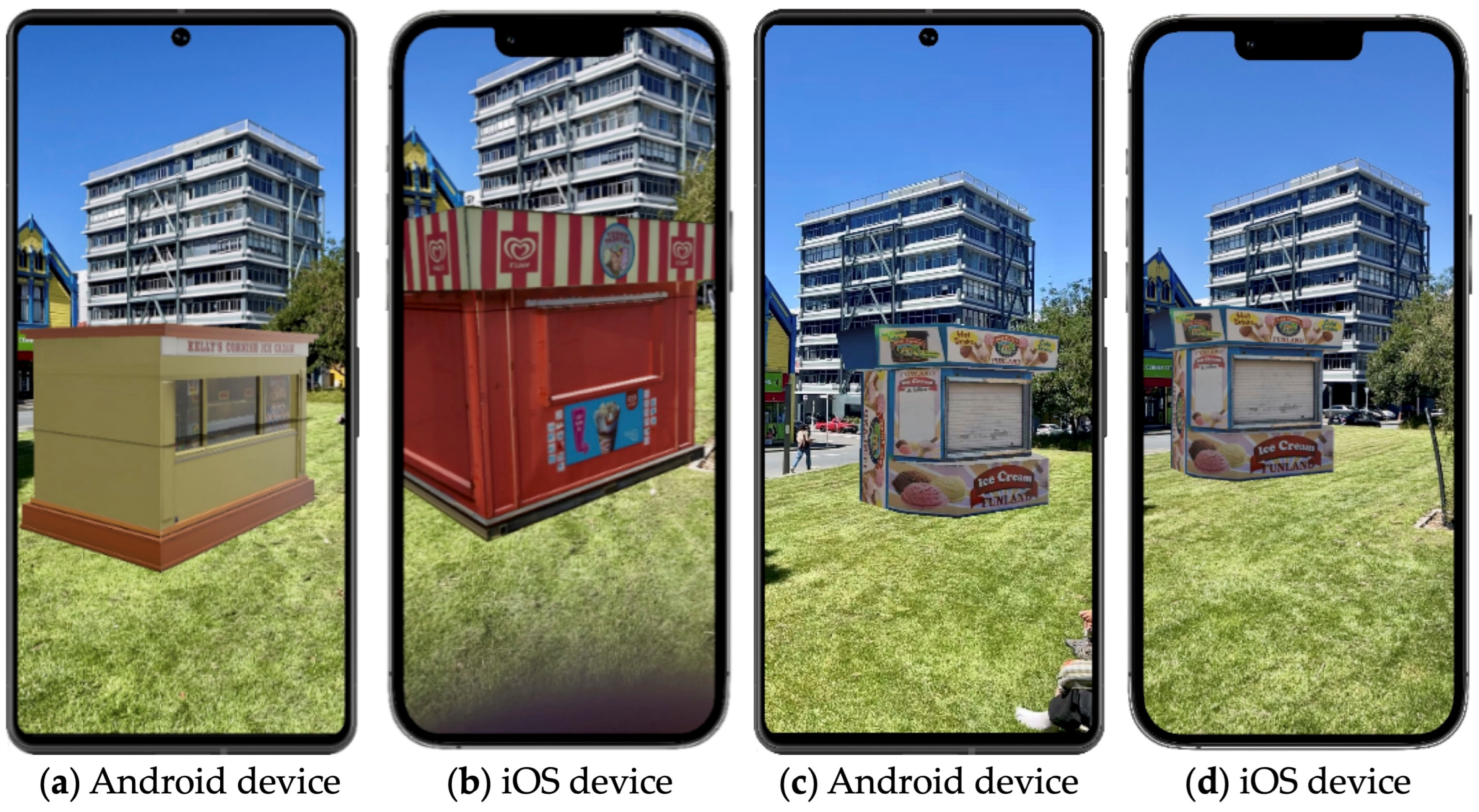
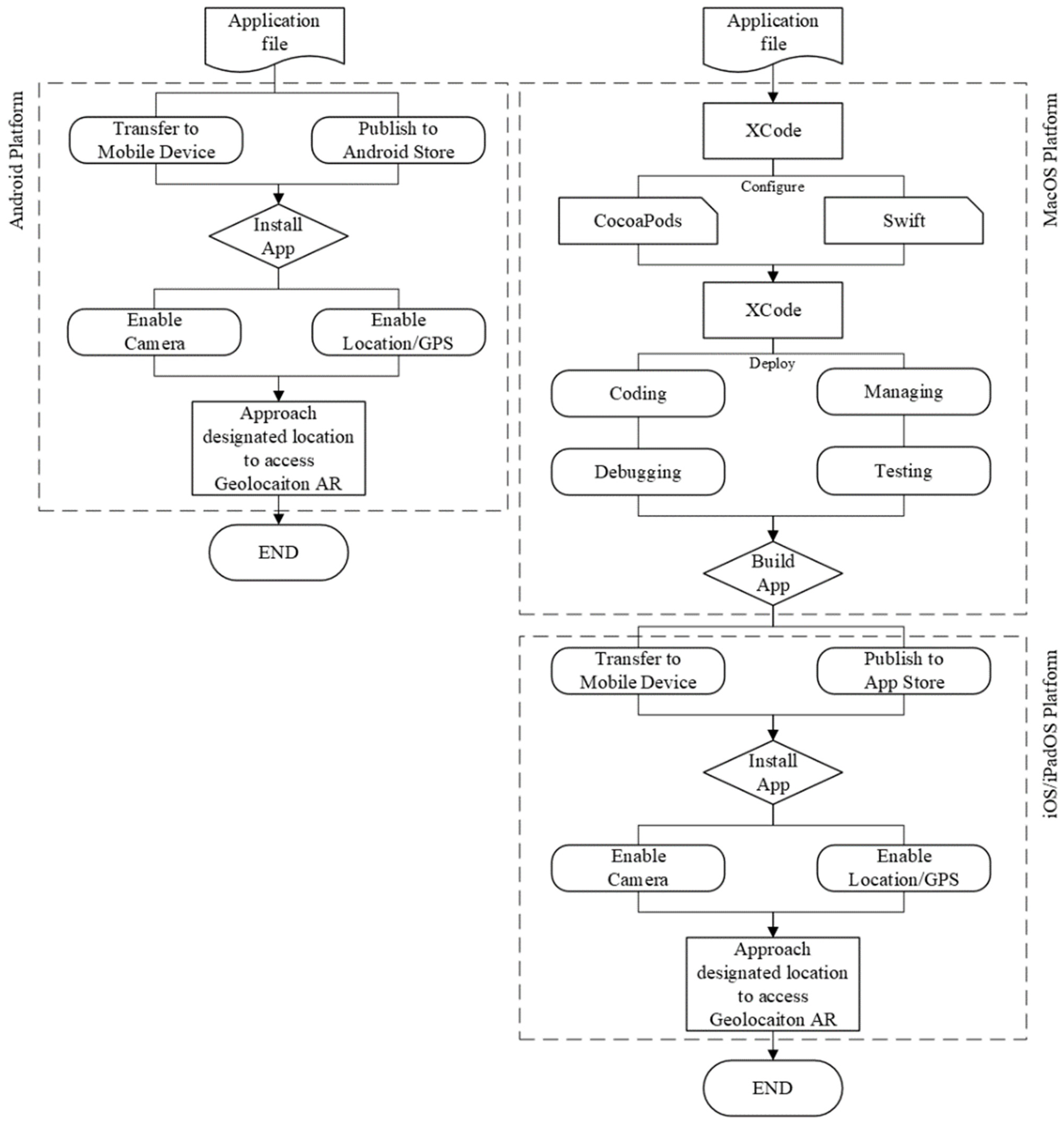
Distinct coloured building models are assigned for Android and iOS platforms and anchored to designated coordinates using Geospatial Creator Anchors. The final application is built for Android and iOS: for Android, the APK is installed directly onto a device, whereas for iOS, deployment is completed via Xcode to an iPhone. The experiment confirmed the feasibility of using Unity for spatially anchored digital content delivery via geolocated AR in urban environments.

4.4.2. Aero

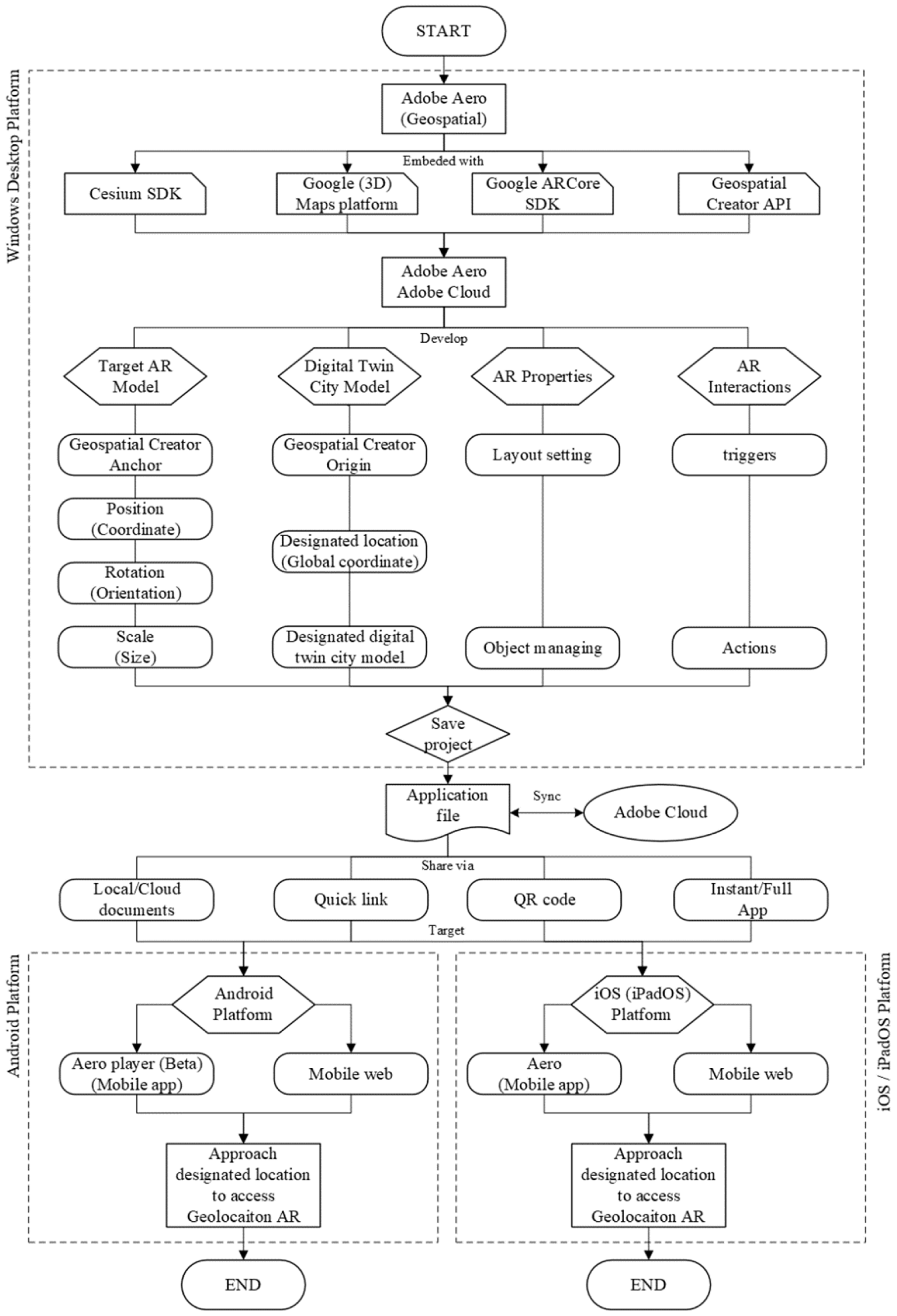
After initiating Adobe Aero (geospatial pre-release version) on the desktop platform, integrated with Google’s Geospatial Creator, it syncs with the Aero mobile app to deploy location-based AR content through their enabled cloud service. A new project is created by selecting “location anchor type,” which automatically loads 3D digital twin tiles from Google Earth support. The experiment again took the site of Cobblestone Park in Wellington City (latitude: −41.29515, longitude: 174.77556), where the 3D city model was visualised. To test the setup, a sample 3D stall structure was imported, positioned, and scaled relative to the digital twin model to ensure accurate spatial alignment. Although Aero provides limited interactivity settings, essential adjustments can be made. The finalised AR project is synced to Adobe Cloud and published across various channels, including quick links, QR codes, and App Clips, enabling broad accessibility without requiring the complete installation of an app. This process demonstrates the feasibility of using Aero for a lightweight, location-based AR deployment using building and landscape data extracted from the digital twin (see Figure 5).

4.5. Outcomes of Unity and Aero Testing

Despite procedural differences between developing geolocated AR applications in Unity and Aero, both approaches have delivered a successful geolocated AR experience of locating an AR on-site supported by DTC data. The Unity-enabled outcomes and Aero outcomes are shown in Figure 6.
The technique pathways for building the geolocated AR system that was described earlier can be summarised and represented in the following roadmaps (see Figure 7 and Figure 8). Unity offers a robust platform for self-developed applications, allowing for extensive customisation and control. In contrast, Adobe Aero provides a streamlined, all-in-one solution designed for ease of use and quick deployment, as seen in Figure 9. Both approaches have validated the core objective: when users hold their mobile devices with the camera and location services authorised, they can view predefined augmented models that are seamlessly overlaid on the physical environment of the designated location.

4.6. Application of Test Cases

Having established that the technical capabilities of the two geolocated AR systems were effective and delivered a suitable user experience, we have applied this approach to some ongoing urban issues in Wellington, with a focus on their integration with the digital twin for information transmission and public interaction. In those cases, we primarily used the Wellington digital twin dataset provided by the Wellington City Council (WCC) and, when necessary, supplemented it with Google’s geospatial data. We primarily applied Aero for these test cases due to its more streamlined process and broader accessibility. Unity could also potentially achieve these results and offer even more.
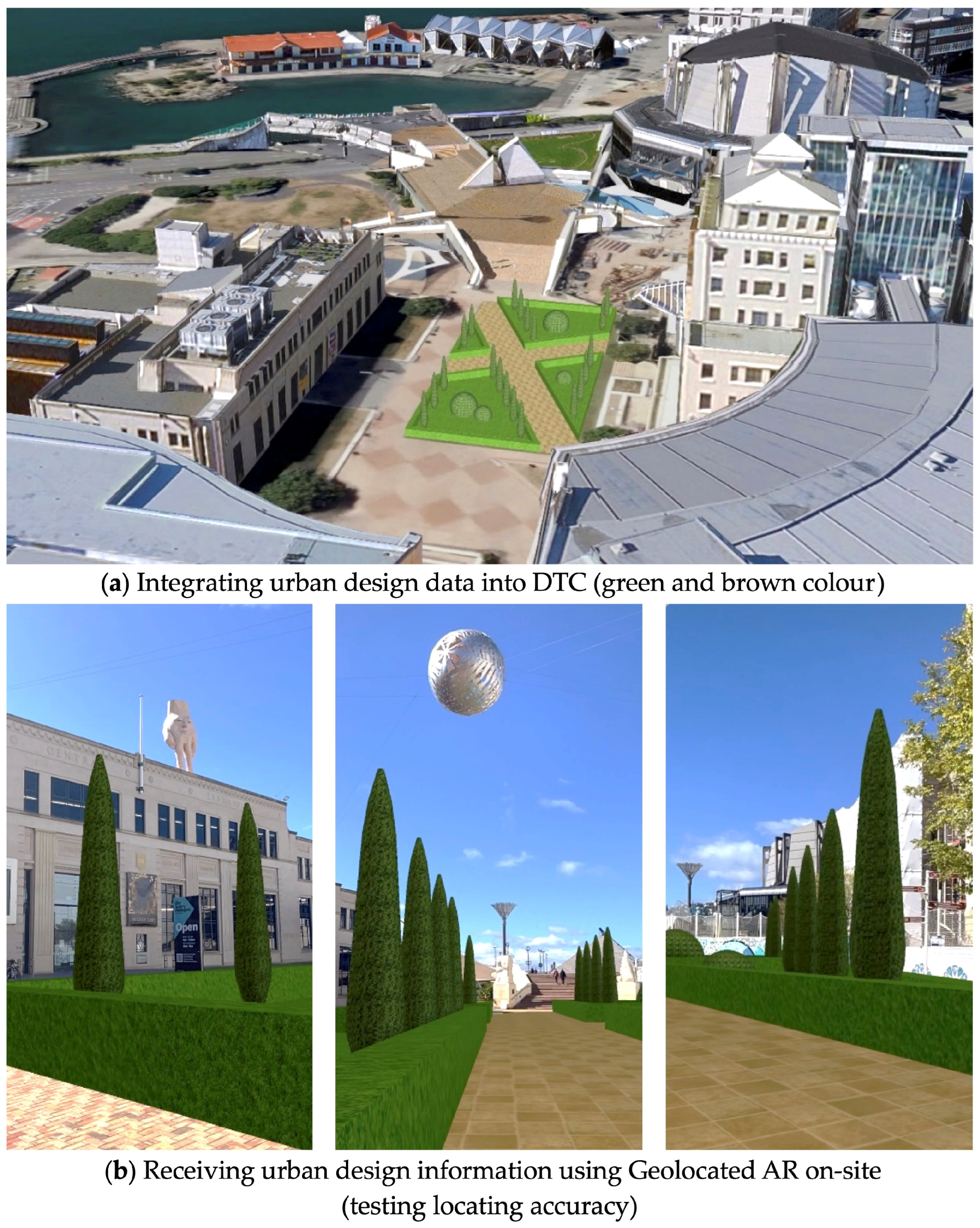
Te Ngakau Civic Square was selected for renewal, so it was chosen to demonstrate the integration of geolocated AR and digital twin for an immersive urban design visualisation. Using spatial data from its digital twin models, an example design scheme was modelled and imported into the on-site AR experience, where it was geolocated and refined. Then, users were allowed to observe and interact with the design on their mobile devices in real time as they moved through the physical space (see Figure 10). This successfully demonstrated that the system provided an intuitive, accessible way for the public to receive urban design information from local authorities, thus enhancing the understanding of design proposals, especially among non-experts.
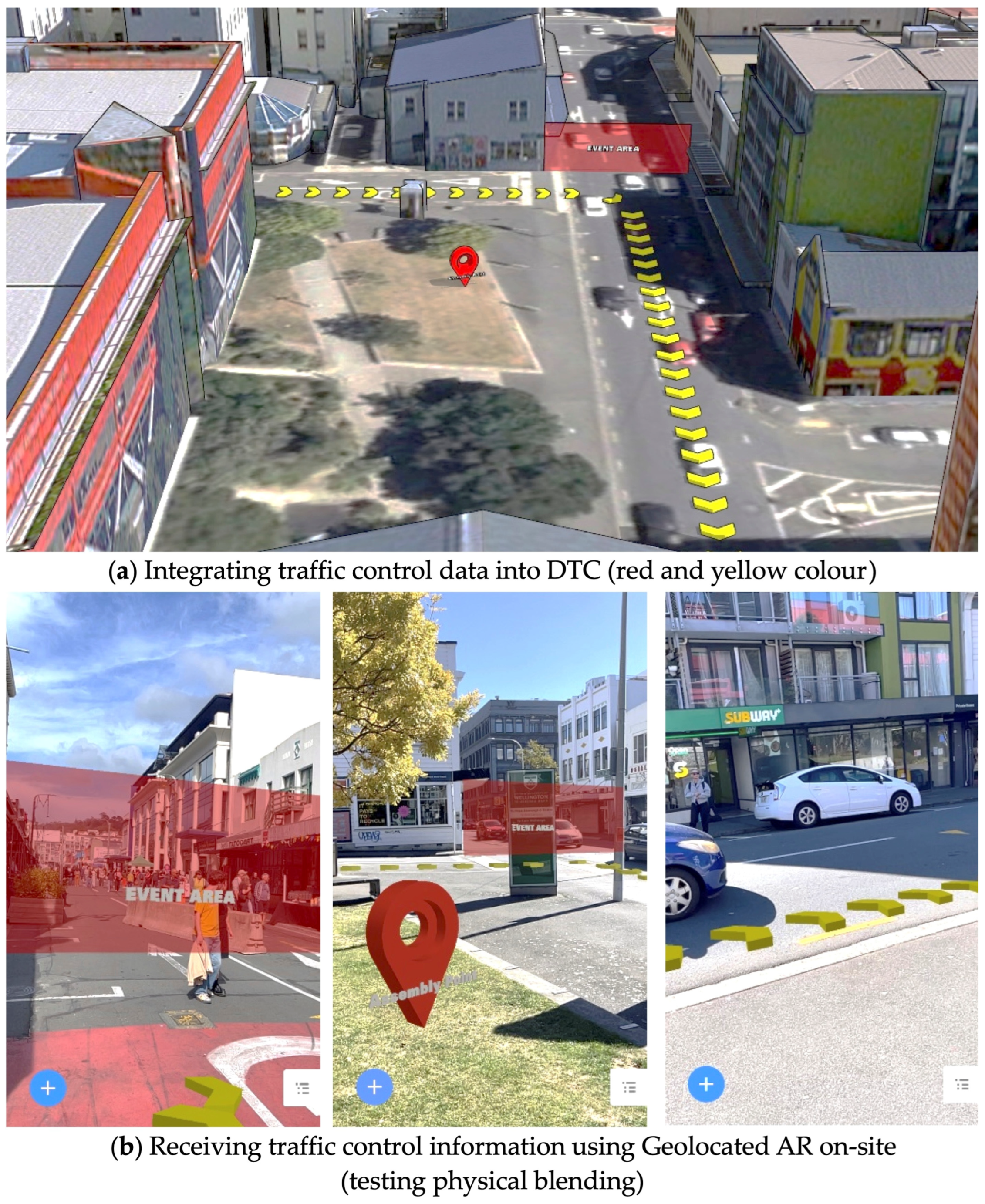
The CubaDupa street festival in Wellington presents a compelling scenario for testing traffic and mobility control through digital twin and geolocated AR technologies. As one of New Zealand’s most significant public events, it requires extensive road closures, detours, and crowd management. Despite traditional signage and static maps, issues such as congestion and misnavigation persist. In our test, simulated traffic control data was embedded into a digital twin and deployed via a geolocated AR system accessible through mobile devices or QR codes. This allowed real-time, location-based navigation and even dynamic updates during the event (see Figure 11). This test demonstrates the potential of geolocated AR, in synergy with digital twins, to transmit citizen-informing data, improve public guidance, and support adaptive spatial management in complex urban environments.
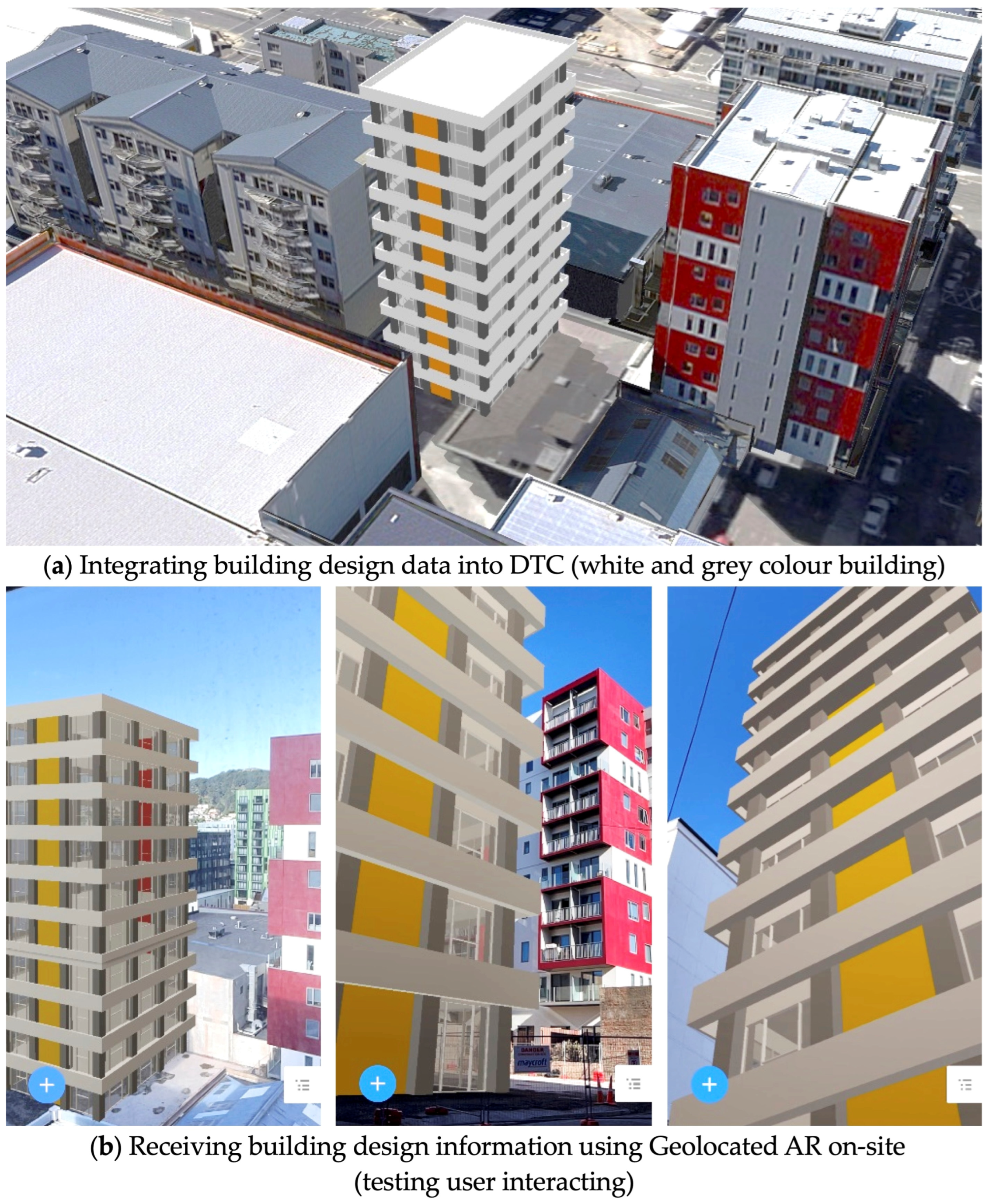
Building design is another key application of this study; a test at 11 Knigges Avenue simulated the proposed redevelopment of a demolished commercial building into a 10-storey residential tower. Due to its location in a dense urban area near educational and residential structures, spatial and environmental impacts are critical. Using digital twin data as the base, design proposals were integrated into a virtual urban context, allowing analysis of factors such as shadowing, view obstruction, and traffic flow. The model was then embedded in a geolocated AR system, enabling real-time, immersive site visualisation on mobile devices (see Figure 12). This test was constructed to facilitate an intuitive understanding of design information and a design evaluation for non-specialists within the actual physical environment.
Besides the three case studies of urban design, architectural design, and traffic control that were mentioned above, we have also applied similar AR-enabled approaches for urban renewal, green planning, urban and building information controls, and even commercial promotions, which are not detailed here. All the applications have shown a strong potential to utilise geolocated AR working in synergy with a digital twin city to support intended spatial-temporal information flows among urban stakeholders. They also indicate the potential for the effective communication of proposals and information to non-specialist citizens whilst on site, using commonly available mobile devices [45].
We have evaluated the technical performance of this prototype with experts and users and have also assessed its technical usability using IsoMetrics and the user engagement scales approach. The technique used and the results are summarised below.

5. Evaluation of the Geolocated AR Approach

The focus of this study is not only to evaluate the usability of the geolocated AR approach but also to assess the AR system development process. As such, the evaluation must consider both the developers’ point of view and the users’ perspectives. Thus, we undertook a mixed evaluation in two parts involving a peer review and user testing.

5.1. IsoMetrics Evaluation of the Technology Implementation

To review and evaluate our proposed approach, we used the IsoMetrics questionnaire to assess the technology’s usability as a user-friendly, apposite tool. The IsoMetrics was proposed by Gediga and Hamborg in 1999 as a user-oriented approach to software system evaluation based on ISO 9241 Part 10, which uses international standard criteria and measures usability quality for human–system interaction and related areas [40]. It provides an effective means of assessing compliance with ISO 9241-10 by supporting both the summative and formative evaluation of software systems [49]. It includes seven principles formulated in response to the ISO standard, which are as follows:
  • Suitability for the task;
  • Self-descriptiveness;
  • Controllability;
  • Conformity with user expectations;
  • Error tolerance;
  • Suitability for individualisation;
  • Suitability for learning.
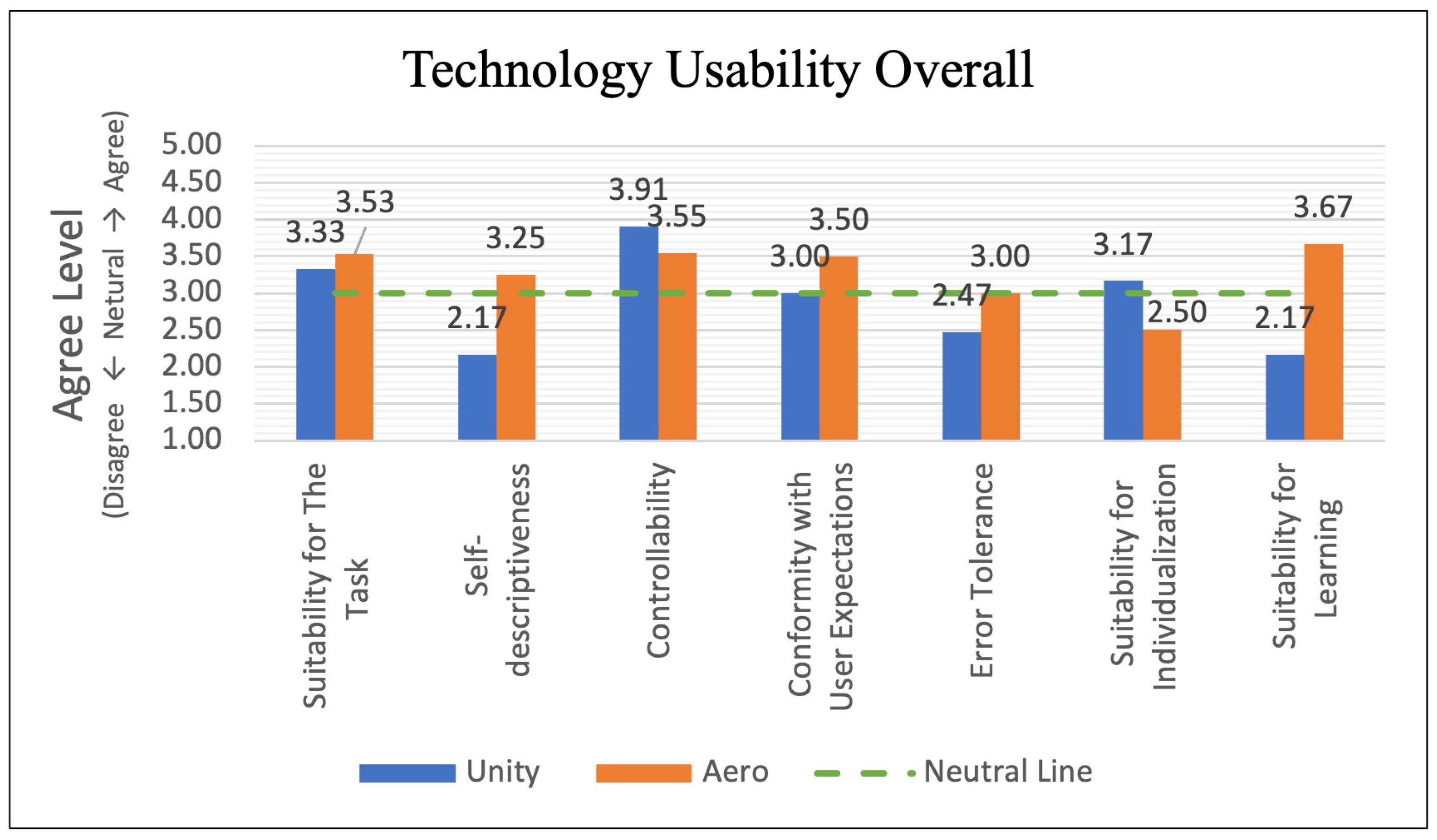
Applying IsoMetricsS (short list version 2.01e) as the evaluation instrument to conduct the summative analysis proved effective. It comprises 75 selected items that were required to examine the seven design principles above; each item was to be rated on a 5-point Likert scale. We invited three subjects who are experts in the architecture and urban design field with experience in developing AR or VR applications. The need for expertise in both areas meant that the initial group available to us was small, but their backgrounds meant that they could provide rigorous technical reviews and comparisons of the Unity- and Aero-enabled systems. The implementation was in the form of a roundtable introduction of the developed system, then a score was collected using the IsoMetricsS questionnaire. Figure 13 shows the overall mean scores for the seven design principles.
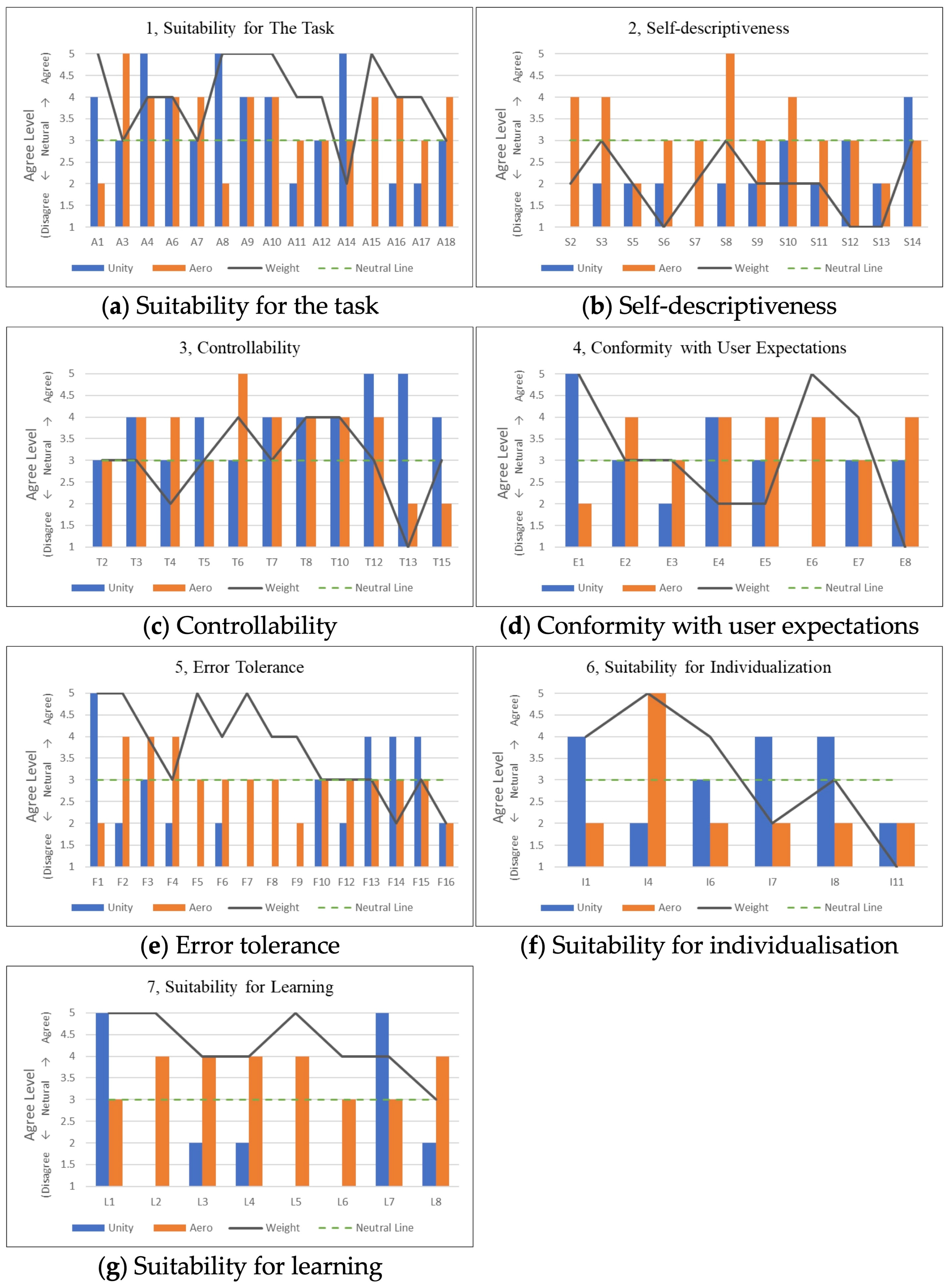
Specifically, the evaluation subscales for each usability criterion are shown in Figure 14.
Reflecting on our proposed technical pathways, which aimed to achieve a functional and effective geolocated AR system, both Unity and Aero proved suitable based on the IsoMetrics ratings. However, Aero displays more user-friendly interaction attributes, as evidenced by higher scores for self-descriptiveness, conformity with user expectations, error tolerance, and suitability for learning. On the other hand, Unity offers more customised features that enable greater control and, hence, make it suitable for individualisation. Among the seven design principles, self-descriptiveness is less relevant because both approaches are relatively new and not fully mature, and they are less critical in this AR system assessment. However, learning suitability is of great importance in this context, as ease of learning directly affects the feasibility of using these tools to develop accessible AR systems that enable improved user interactions.

5.2. UES for Users

The successful application of the geolocated AR approach depended on how well users interacted and engaged with these technologies. User engagement scales (UES) refer to the ability to attract and sustain participation in digital environments. It allows researchers to determine whether participants feel motivated to interact with the system, provide feedback, and actively contribute to urban discussion. Evidence suggested that the UES is a reliable and valid means of enabling self-report questionnaires for capturing subjective user engagement [50,51].
Through subsequent development, the UES approach was applied and resulted in a 31-item self-report instrument that comprised six main factors or dimensions:
  • Novelty: Curiosity and interest in the interactive task.
  • Aesthetics: The attractiveness and visual appeal of the interface.
  • Focused Attention: Feeling absorbed in the interaction and losing.
  • Felt Involvement: The sense of being “drawn in” and having fun.
  • Perceived Usability: The negative affect experienced as a result of the interaction and the degree of control and effort expended.
  • Endurability: The overall success of the interaction and users’ willingness to recommend an application to others or engage with it in future.
In this study, we adopted UES (version 11, 2023) with a strategically simplified structure to avoid participant fatigue and redundancy in order to ensure an efficient, scalable evaluation. The evaluation used 7-point Likert scales scored from the most negative (−3), to neutral (0), to the most positive (+3). The six dimensions were guided by questions and measured with pairs of contrasting adjectives (e.g., “unacceptable—excellent”), allowing participants to express their engagement level for each scale in this system.
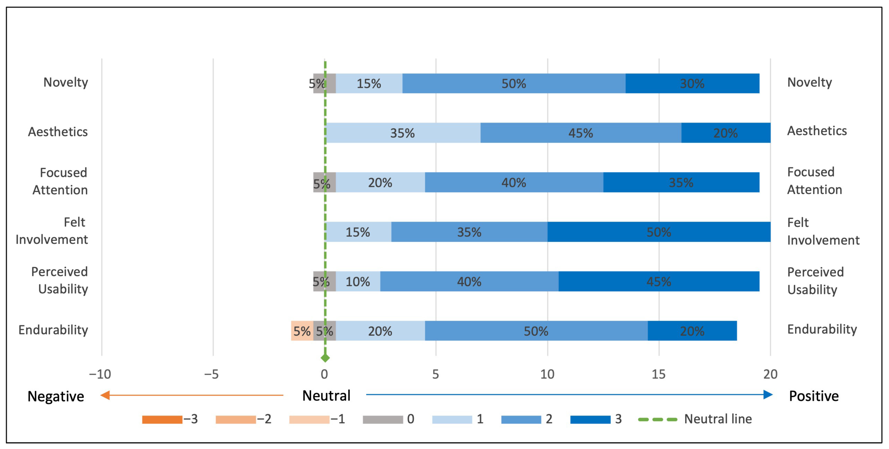
This survey was intended to collect holistic and indicative findings, as it was a very early-stage survey, so it employed an undifferentiated method without segmenting the participants’ backgrounds. A total of 20 valid results were obtained after recruiting the participants to test a building design case study. Figure 15 shows the statistical response of this survey.
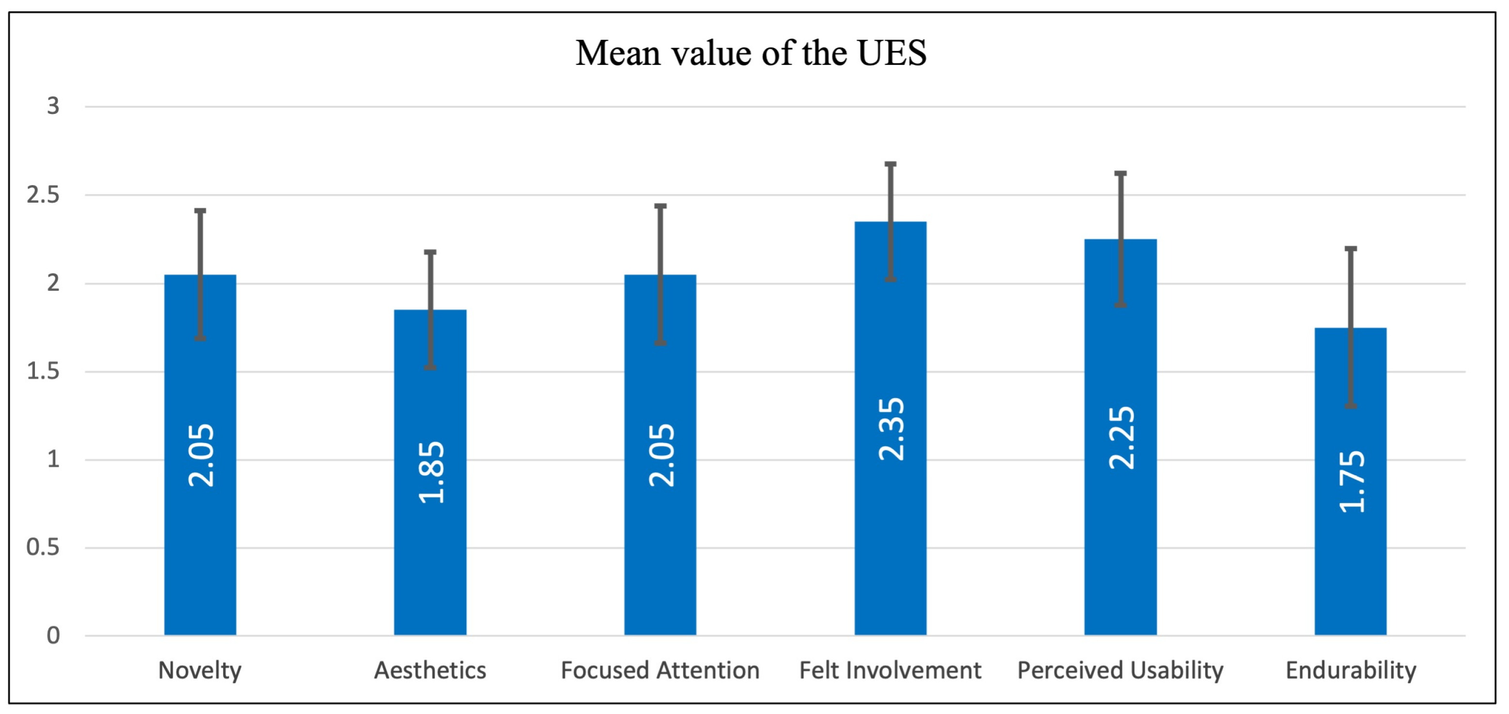
In a further analysis, the mean value of each attribute captured the subjective user engagement level. The means have been calculated, with standard deviation whiskers applied, as shown in Figure 16.
In addition, the reliability analysis and descriptive statistics of this evaluation process were conducted to evaluate their internal consistency and distribution characteristics. The results are shown in Table 3.
We used three variants of a proposed building design for a vacant site, with geo-anchored on-site design information and visualisation provided to the users. The mean values given by the users across all six dimensions show strong positive responses. Users rated the interface and the response highest in novelty, focused attention, felt involvement, and perceived usability. This strong performance indicates a low cognitive barrier, good user flow, and clear informational structure, which together foster a more immersive and satisfying interaction. This straightforward workflow appears to have enabled users to engage without confusion or friction, allowing them to remain focused and to perceive values in the AR interaction over time.
The Cronbach’s alpha values for the sub-scales of the UES assessment all exceed 0.80, indicating a high level of internal consistency and demonstrating good to excellent reliability across these interaction phases. This suggests that participants responded consistently to the subscales for each UES measurement during their engaging experience. These analyses of means and standard deviations provide deeper insight into the central tendencies and variability of user responses about the proposed geolocated AR approach and its future development.
In conclusion, the evaluation highlights the significant promise of using geolocated AR as an interface for public engagement with digital twin city environments. The research revealed further technological challenges that need attention but also showed that the developed geolocated AR system has significant potential to deliver a user-friendly and practical means to link on-site user feedback to a DTC dataset. Both Unity and Aero presented certain challenges during the prototyping process. For example, common issues in Unity include version incompatibilities between SDKs and APIs, software limitations within the tools provided, and a high demand for coding and debugging skills. In contrast, Aero encountered file transmission failures and cloud service integration crashes. Overall, while Unity is a more advanced and complex platform for developing a geolocated AR system than Aero, the technical and usability barriers limit accessibility for general users and individual developers. Aero is considerably more streamlined and provides ready-made solutions that simplify and expedite development, enabling broader user interactions and simpler information flows.
Some technical issues that we experienced during our prototype implementation and testing are worth noting. First, the accuracy of geolocation data was generally good. However, it could occasionally become unstable, with deviations of up to 2 m from the actual location due to multiple factors such as user movement, GPS signal strength, environmental conditions, and device computing capabilities; the variations were infrequent and inconsistent. The maximum error noted was 2 m, and normally the accuracy was close enough to give an accurate representation. Second, integration with the physical scene is limited, as AR content always appears in the foreground without full occlusion capability. It is also somewhat deficient in semantic scene recognition. However, tools like Google’s Scene Semantics API and preloaded spatial data offer future promise in addressing this issue. Third, device capability significantly affects performance; high-end devices with LiDAR outperform mid-range phones, suggesting external LiDAR sensors could improve spatial awareness for larger-scale applications. Lastly, while Unity enables broader AR content activation over distance, Aero manages larger content volumes more efficiently, revealing trade-offs in scalability and interactivity across platforms. These findings highlight both the potential and current limitations of deploying geolocated AR in complex urban environments.

6. Conclusions

This study has tested geolocated AR as a digital tool to both convey urban information and integrate human interaction with a connection to a DTC platform. Although both DTC and AR technologies are still developing, we have successfully prototyped a combination of technologies that demonstrate technical feasibility for transmitting spatiotemporal information and that have significant potential to enhance spatial awareness in urban settings. With the widespread use of smart devices equipped with GPS in our daily lives, the prototype system illustrated and tested as described above shows that urban information can be more accessible and intuitive, enhancing individual experiences that enable visualising and perceiving urban data in a useful, practical and user-friendly way. We summarise the three key outcomes below:
  • Visualisation of Urban Information: Urban data is transformed into augmented digital content within the digital twin framework and positioned at reasonably precise geographic coordinates. Users can access this information through the geolocated AR system with their mobile devices when they arrive at predefined locations, ensuring effective and context-sensitive delivery.
  • Flexible Integration of Content: Various forms of information, including 2D and 3D spatial data, can be incorporated if they can be modelled in real-time environmental contexts. While our experiment focused on visual content, evidence suggests that audio and video elements are also feasible, although they remain untested in this study.
  • Facilitating the Information Workflow: Our case study demonstrates how urban information can be transformed into geolocated AR content, enabling a one-way information flow from professional creators to the public. It also shows potential for how citizen feedback can be captured and tied to site location and context, though this workflow was not fully implemented. Our future studies will further explore feedback workflows that test the bi-directional interactions of this approach. However, we believe the research establishes that the data collected is appropriately structured, accurate enough and sufficiently useful to be capable of integration with a digital twin, which would be worthwhile.
In response to the motivation stated at the start of this article to enhance information transmission and public interaction, our study has sought to deliver urban information in a visually engaging way, thereby improving public awareness of urban issues. This fosters dynamic communication between citizens and the local authorities, promoting a participatory, informed approach to urban development.
However, we can reflect on some limitations. Our work is positioned as an exploratory and illustrative investigation, focused on establishing technical feasibility rather than a generalisable complete system. We have prototyped a beta version of a technology combination that focuses on the technical perspective, integrating carefully selected and manipulated mobile device tools. Other tools and approaches may also achieve a similar geolocated AR system. Also, the AR evaluation will be subject to broader testing and validation. Our findings reflect the performance of the current tool versions, devices, location, and conditions, which may shift as AR technology advances. In addition, the study does not include a comparative baseline against conventional citizen engagement methods; therefore, it does not claim a demonstrated superiority over existing approaches. It augments what is currently available.
Furthermore, this study investigated a one-way direction workflow of “informing” from desktop (professional end) to mobile (public end); the reverse workflow of “feedback” from mobile to desktop remains crucial for fostering deeper public engagement and is on our future agenda. Establishing a successful, complete bi-directional workflow for the geolocated AR system is intended to be a subsequent stage of development and would create a closed loop with the DTC platform, enhancing its role as a fully interactive, integrated urban information medium for urban environments and citizen interaction.

Author Contributions

Conceptualisation, X.Z., A.B. and A.P.; methodology, X.Z., A.B. and A.P.; software, X.Z.; validation, X.Z., A.B. and A.P.; formal analysis, X.Z.; investigation, X.Z.; resources, X.Z. and A.B.; data curation, A.B. and A.P.; writing—original draft preparation, X.Z.; writing—review and editing, A.B.; visualisation, X.Z.; supervision, A.B. and A.P.; project administration, A.B.; funding acquisition, X.Z. All authors have read and agreed to the published version of the manuscript.

Funding

This research was funded by the China Scholarship Council (CSC), grant number CSC202208330051.

Institutional Review Board Statement

The study was conducted in accordance with the Declaration of Helsinki and was approved by the Human Ethics Committee of Victoria University of Wellington (protocol code 31483, 18 April 2024).

Informed Consent Statement

Informed consent was obtained from all subjects involved in the study.

Data Availability Statement

The data and/or models that support the findings of this study are available upon reasonable request.

Acknowledgments

The authors express their gratitude to the Wellington City Council (WCC) for providing the Wellington digital twin model dataset, as well as to peers for their technical guidance and valuable contributions to this work.

Conflicts of Interest

The authors declare no conflicts of interest. The funders had no role in the design of the study; in the collection, analyses, or interpretation of data; in the writing of the manuscript; or in the decision to publish the results.

Abbreviations

The following abbreviations are used in this manuscript:
APIApplication Programming Interface
ARAugmented Reality
BIMBuilding Information Modelling
CIMCity Information Modelling
DTDigital Twin
DTCDigital Twin City
GISGeographic Information Systems
GPSGlobal Positioning System
HCIHuman–Computer Interaction
ICTInformation and Communications Technology
IoTInternet of Things
MRMixed Reality
SDKsSoftware Development Kits
SLAMSimultaneous Localisation and Mapping
UAVUnmanned Aerial Vehicle
UESUser Engagement Scales
URPUniversal Render Pipeline (in Unity)
VRVirtual Reality
WCCWellington City Council

References

  1. Angelidou, M. Smart Cities: A Conjuncture of Four Forces. Cities 2015, 47, 95–106. [Google Scholar] [CrossRef]
  2. Marsal-Llacuna, M.L.; Colomer-Llinàs, J.; Meléndez-Frigola, J. Lessons in Urban Monitoring Taken from Sustainable and Livable Cities to Better Address the Smart Cities Initiative. Technol. Forecast. Soc. Change 2015, 90, 611–622. [Google Scholar] [CrossRef]
  3. Grieves, M.; Vickers, J. Digital Twin: Mitigating Unpredictable, Undesirable Emergent Behavior in Complex Systems. In Transdisciplinary Perspectives on Complex Systems; Springer: Cham, Switzerland, 2016; pp. 85–113. [Google Scholar] [CrossRef]
  4. Bibri, S.E.; Krogstie, J. Smart sustainable cities of the future: An extensive interdisciplinary literature review. Sustain. Cities Soc. 2017, 31, 183–212. [Google Scholar] [CrossRef]
  5. Sharifi, A.; Khavarian-Garmsir, A.R.; Kummitha, R.K.R. Contributions of Smart City Solutions and Technologies to Resilience against the COVID-19 Pandemic: A Literature Review. Sustainability 2021, 13, 8018. [Google Scholar] [CrossRef]
  6. Berridge, P.; Koch, V.; Brown, A.G.P. Information Spaces for Mobile City Access. Int. J. Archit. Comput. 2003, 1, 34–45. [Google Scholar] [CrossRef]
  7. Knight, M.; Saeed, G.; Chen, Y.-H.; Brown, A. Remote Location in an Urban Digital Model. In Proceedings of the Predicting the Future, the 25th eCAADe Conference, Frankfurt am Main, Germany, 26–29 September 2007; pp. 581–587. [Google Scholar] [CrossRef]
  8. Brown, A.; Knight, M.; Chen, Y.-C.; Saeed, G. City Information Delivered to Mobile Digital Devices: Reflection on Contemporary Potentials and Problems. In Communicating Space(s), Proceedings of the 24th eCAADe Conference, Volos, Greece, 6–9 September 2006; University of Thessaly: Volos, Greece, 2006; pp. 146–150. [Google Scholar] [CrossRef]
  9. Khajavi, S.H.; Motlagh, N.H.; Jaribion, A.; Werner, L.C.; Holmström, J. Digital Twin: Vision, Benefits, Boundaries, and Creation for Buildings. IEEE Access 2019, 7, 147406–147419. [Google Scholar] [CrossRef]
  10. Ketzler, B.; Naserentin, V.; Latino, F.; Zangelidis, C.; Thuvander, L.; Logg, A. Digital Twins for Cities: A State of the Art Review. Built Environ. 2020, 46, 547–573. [Google Scholar] [CrossRef]
  11. Deng, T.; Zhang, K.; Shen, Z.-J. A Systematic Review of a Digital Twin City: A New Pattern of Urban Governance toward Smart Cities. J. Manag. Sci. Eng. 2021, 6, 125–134. [Google Scholar] [CrossRef]
  12. White, G.; Zink, A.; Codecá, L.; Clarke, S. A Digital Twin Smart City for Citizen Feedback. Cities 2021, 110, 103064. [Google Scholar] [CrossRef]
  13. Stoter, J.; Ohori, K.A.; Noardo, F. Digital Twins: A Comprehensive Solution or Hopeful Vision? GIM Int. 2021. Available online: https://www.gim-international.com/content/article/digital-twins-a-comprehensive-solution-or-hopeful-vision (accessed on 1 January 2026).
  14. Castelli, G.; Cesta, A.; Diez, M.; Padula, M.; Ravazzani, P.; Rinaldi, G.; Savazzi, S.; Spagnuolo, M.; Strambini, L.; Tognola, G.; et al. Urban Intelligence: A Modular, Fully Integrated, and Evolving Model for Cities Digital Twinning. In Proceedings of the 2019 IEEE 16th International Conference on Smart Cities: Improving Quality of Life Using ICT & IoT and AI (HONET-ICT), Charlotte, NC, USA, 6–9 October 2019; pp. 033–037. [Google Scholar] [CrossRef]
  15. Tomko, M.; Winter, S. Beyond Digital Twins—A Commentary. Environ. Plan. B 2019, 46, 395–399. [Google Scholar] [CrossRef]
  16. Li, X.; Liu, H.; Wang, W.; Zheng, Y.; Lv, H.; Lv, Z. Big Data Analysis of the Internet of Things in the Digital Twins of a Smart City Based on Deep Learning. Future Gener. Comput. Syst. 2022, 128, 167–177. [Google Scholar] [CrossRef]
  17. Mohammadi, N.; Taylor, J.E. Smart City Digital Twins. In Proceedings of the 2017 IEEE Symposium Series on Computational Intelligence (SSCI), Honolulu, HI, USA, 27 November–1 December 2017; pp. 1–5. [Google Scholar] [CrossRef]
  18. Behrad, S.; Bertin, E.; Tuffin, S.; Crespi, N. A New Scalable Authentication and Access Control Mechanism for 5G-Based IoT. Future Gener. Comput. Syst. 2020, 108, 46–61. [Google Scholar] [CrossRef]
  19. Ferré-Bigorra, J.; Casals, M.; Gangolells, M. The Adoption of Urban Digital Twins. Cities 2022, 131, 103905. [Google Scholar] [CrossRef]
  20. Ford, D.N.; Wolf, C.M. Smart Cities with Digital Twin Systems for Disaster Management. J. Manag. Eng. 2020, 36, 04020027. [Google Scholar] [CrossRef]
  21. Dembski, F.; Wössner, U.; Letzgus, M.; Ruddat, M.; Yamu, C. Urban Digital Twins for Smart Cities and Citizens: The Case Study of Herrenberg, Germany. Sustainability 2020, 12, 2307. [Google Scholar] [CrossRef]
  22. Deren, L.; Wenbo, Y.; Zhenfeng, S. Smart City Based on Digital Twins. Comput. Urban Sci. 2021, 1, 4. [Google Scholar] [CrossRef]
  23. Behrouz, T.; Erhan, H.; Abuzuraiq, A.M. D-ARE: A Location-Based Augmented Reality Tool for Public Engagement in Design of Built Environment. In Proceedings of the International Conference on Computer-Aided Architectural Design Research in Asia, Singapore, 20–26 April 2024; Volume 2, pp. 191–200. [Google Scholar] [CrossRef]
  24. Charitonidou, M. Urban Scale Digital Twins in Data-Driven Society: Challenging Digital Universalism in Urban Planning Decision-Making. Int. J. Archit. Comput. 2022, 20, 238–253. [Google Scholar] [CrossRef]
  25. Nochta, T.; Wan, L.; Schooling, J.M.; Parlikad, A.K. A Socio-Technical Perspective on Urban Analytics: The Case of City-Scale Digital Twins. J. Urban Technol. 2021, 28, 263–287. [Google Scholar] [CrossRef]
  26. Joss, S.; Sengers, F.; Schraven, D.; Caprotti, F.; Dayot, Y. The Smart City as Global Discourse: Storylines and Critical Junctures across 27 Cities. J. Urban Technol. 2019, 26, 3–34. [Google Scholar] [CrossRef]
  27. Milan, S.; Treré, E. Big Data from the South(s): Beyond Data Universalism. Telev. New Media 2019, 20, 319–335. [Google Scholar] [CrossRef]
  28. Raes, L.; Michiels, P.; Adolphi, T.; Tampere, C.; Dalianis, A.; McAleer, S.; Kogut, P. DUET: A Framework for Building Interoperable and Trusted Digital Twins of Smart Cities. IEEE Internet Comput. 2022, 26, 43–50. [Google Scholar] [CrossRef]
  29. Prime, G.W. Virtual Singapore—Building a 3D-Empowered Smart Nation. Geospatial World. Available online: https://www.geospatialworld.net/prime/case-study/national-mapping/virtual-singapore-building-a-3d-empowered-smart-nation (accessed on 1 January 2026).
  30. Schrotter, G.; Hürzeler, C. The Digital Twin of the City of Zurich for Urban Planning. PFG—J. Photogramm. Remote Sens. Geoinf. Sci. 2020, 88, 99–112. [Google Scholar] [CrossRef]
  31. Sitowise. Digital Twins Open a New World for Urban Development. Sitowise.com. Available online: https://www.sitowise.com/customer-story/digital-twins-open-new-world-urban-development (accessed on 1 January 2026).
  32. Cocchia, A. Smart and Digital City: A Systematic Literature Review. In Smart City; Springer: Cham, Switzerland, 2014; pp. 13–43. [Google Scholar] [CrossRef]
  33. Alva, P.; Mosteiro-Romero, M.; Miller, C.; Stouffs, R. Digital Twin-Based Resilience Evaluation of District-Scale Archetypes. In Proceedings of the International Conference on Computer-Aided Architectural Design Research in Asia, Sydney, Australia, 9–15 April 2022; pp. 525–534. [Google Scholar] [CrossRef]
  34. Ke, S.; Xiang, F.; Zhang, Z.; Zuo, Y. An Enhanced Interaction Framework Based on VR, AR and MR in Digital Twin. Procedia CIRP 2019, 83, 753–758. [Google Scholar] [CrossRef]
  35. Wang, Y.; Lin, Y.-S. Public Participation in Urban Design with Augmented Reality Technology Based on Indicator Evaluation. Front. Virtual Real. 2023, 4, 1071355. [Google Scholar] [CrossRef]
  36. Arena, F.; Collotta, M.; Pau, G.; Termine, F. An Overview of Augmented Reality. Computers 2022, 11, 28. [Google Scholar] [CrossRef]
  37. Saßmannshausen, S.M.; Radtke, J.; Bohn, N.; Hussein, H.; Randall, D.; Pipek, V. Citizen-Centered Design in Urban Planning: How Augmented Reality Can Be Used in Citizen Participation Processes. In Proceedings of the Designing Interactive Systems Conference 2021, Virtual, 28 June–2 July 2021; pp. 250–265. [Google Scholar] [CrossRef]
  38. Enders, M.R.; Hoßbach, N. Dimensions of Digital Twin Applications: A Literature Review. In AMCIS 2019 Proceedings; Association for Information Systems: Atlanta, GA, USA, 2019; p. 20. Available online: https://aisel.aisnet.org/amcis2019/org_transformation_is/org_transformation_is/20 (accessed on 1 January 2026).
  39. Jadid, A.; Koplin, M.; Siegert, S.; Hering-Bertram, M.; Paelke, V.; Teschke, T.; Eirund, H. Express Yourself/City—Smart Participation Culture Technologies. In Smart Cities in the Mediterranean; Progress in IS; Springer: Cham, Switzerland, 2017; pp. 175–194. [Google Scholar] [CrossRef]
  40. International Organization for Standardization. ISO 9241-10:1996; Ergonomic Requirements for Office Work with Visual Display Terminals (VDTs)—Part 10: Dialogue Principles. ISO: Geneva, Switzerland, 1996.
  41. Brito, P.Q.; Stoyanova, J. Marker versus Markerless Augmented Reality. Which Has More Impact on Users? Int. J. Hum.–Comput. Interact. 2017, 34, 819–833. [Google Scholar] [CrossRef]
  42. Oufqir, Z.; El Abderrahmani, A.; Satori, K. From Marker to Markerless in Augmented Reality. In Embedded Systems and Artificial Intelligence, Advances in Intelligent Systems and Computing; Bhateja, V., Satapathy, S., Satori, H., Eds.; Springer: Singapore, 2020; Volume 1076, pp. 599–612. [Google Scholar] [CrossRef]
  43. Khairuddin, A.R.; Talib, M.S.; Haron, H. Review on Simultaneous Localisation and Mapping (SLAM). In Proceedings of the 2015 IEEE International Conference on Control System, Computing and Engineering (ICCSCE), Penang, Malaysia, 27–29 November 2015; pp. 85–90. [Google Scholar] [CrossRef]
  44. Ramtohul, A.; Khedo, K.K. Augmented Reality Systems in the Cultural Heritage Domains: A Systematic Review. Digit. Appl. Archaeol. Cult. Herit. 2024, 32, e00317. [Google Scholar] [CrossRef]
  45. Zhang, X.; Brown, A.; Pelosi, A. Citizen Interaction with a Digital City Twin. In Proceedings of the 43rd Conference on Education and Research in Computer Aided Architectural Design in Europe (eCAADe 2025), Ankara, Turkey, 1–5 September 2025; Volume 2, pp. 345–354. [Google Scholar] [CrossRef]
  46. Google. Build Global-Scale, Immersive, Location-Based AR Experiences with the ARCore Geospatial API. ARCore. Available online: https://developers.google.com/ar/develop/geospatial (accessed on 1 January 2026).
  47. Google. Geospatial Creator. ARCore. Available online: https://developers.google.com/ar/geospatialcreator (accessed on 1 January 2026).
  48. Google. Enable AR in Your iOS App. ARCore. Available online: https://developers.google.com/ar/develop/ios/enable-arcore (accessed on 1 January 2026).
  49. Gediga, G.; Hamborg, K.-C.; Düntsch, I. The IsoMetrics Usability Inventory: An Operationalisation of ISO 9241-10 Supporting Summative and Formative Evaluation of Software Systems. Behav. Inf. Technol. 1999, 18, 151–164. [Google Scholar] [CrossRef]
  50. O’Brien, H.; Toms, E. The Development and Evaluation of a Survey to Measure User Engagement. J. Am. Soc. Inf. Sci. Technol. 2010, 61, 50–69. [Google Scholar] [CrossRef]
  51. O’Brien, H.; Cairns, P.; Hall, M. A Practical Approach to Measuring User Engagement with the Refined User Engagement Scale (UES) and New UES Short Form. Int. J. Hum.-Comput. Stud. 2018, 112, 28–39. [Google Scholar] [CrossRef]
Figure 1. The proposed digital twin city (DTC) layers of framework.
Urbansci 10 00176 g001
Figure 2. The proposed geolocated AR system linked with a digital twin.
Urbansci 10 00176 g002
Figure 3. The extraction of data from the digital twin and transmission to a mobile device.
Urbansci 10 00176 g003
Figure 4. The developed geolocated AR system using Unity.
Urbansci 10 00176 g004
Figure 5. The developed geolocated AR system using Aero.
Urbansci 10 00176 g005
Figure 6. The geolocated AR outcomes on mobile devices using Unity (a,b) and Aero (c,d).
Urbansci 10 00176 g006
Figure 7. The process roadmap for developing the geolocated AR system via Unity, part 1.
Urbansci 10 00176 g007
Figure 8. The process roadmap for developing the geolocated AR system via Unity, part 2.
Urbansci 10 00176 g008
Figure 9. The process roadmap for developing the geolocated AR system via Aero.
Urbansci 10 00176 g009
Figure 10. The urban design example utilising the geolocated AR system.
Urbansci 10 00176 g010
Figure 11. A traffic control example utilising the geolocated AR system.
Urbansci 10 00176 g011
Figure 12. A building design example utilising the geolocated AR system.
Urbansci 10 00176 g012
Figure 13. The overall technology usability assessment using IsoMetricsS of the geolocated AR system.
Urbansci 10 00176 g013
Figure 14. Subscale assessment of developing a geolocated AR system using IsoMetricsS.
Urbansci 10 00176 g014
Figure 15. The statistical response of UES.
Urbansci 10 00176 g015
Figure 16. The mean value result of each factor in UES.
Urbansci 10 00176 g016
Table 1. AR development platforms software key features comparison.
ItemsA-FrameUnityUnreal Engine 5Adobe AeroReality Composer (Incl.Pro)Windows Mixed Reality
Key
features
1. Open-source web framework for building 3D and WebXR experiences1. Cross-platform game engine to produce real-time 2D and 3D experiences for game or immersive technology1. Multi-platform, powerful real-time game engine with high-quality graphics and rendering1. All-in-one AR authoring and viewing platform with a wide range of digital content support 1. Specified for creating AR experiences for Apple’s ecosystem only1. A platform embedded within Windows 10 and 11, which provides VR/AR/MR experience with compatible head-mounted displays
2. Based on top of the HTML to reach all platforms via the web2. Covers the widest platforms, especially suitable for developing mobile projects2. High-performance requirement for creating AAA titles and digital content, suitable for PC heavyweight large-scale projects 2. Cross-platform solution and mobile-friendly with no coding and minimal 3D experience required2. A visual development environment solution, which offers a user-friendly, drag-and-drop, intuitive interface with or without coding.2. Features an AR/MR operating environment in which any Universal Windows Platform app can run
3. Unlimited access to JavaScript, DOM APIs, three.js, WebVR, and WebGL.3. Supports the widest range of AR SDKs and API, and includes the most tools, libraries, plugins and customisation features3. Various support of the toolkit, and the assets include 3D models, textures, scripts, and shadows3. Intuitive for designers to create, edit, interact, and publish AR works3. Limited to Apple’s SDKs and toolkits only, with a pre-built library and built-in physics engine for AR3. Tightly integrated and enabled various HMD MR devices
4. Based on web development, making it simple and accessible4. Simple to learn and use with a beginner-friendly interface, support low-coding or non-coding for non-techies 4. Complex interface and a steep learning curve for developers 4. Easy for viewers to receive, view, and collaborate with the interactive AR experience 4. Visual creation and logic design are simple for beginners, and advanced features can be accessed with Pro4. Interact with digital content in physical spaces to blend the real world with digital experiences.
5. Component-based Architecture makes it a powerful and versatile tool for web-based 3D development5. Good graphics with lightweight and low-level scale projects, suitable for mobile and indie development5. Cutting-edge graphics and state-of-the-art visuals to transcend reality and achieve digital realism 5. Multiple pathways and convenient to bridge the physical and digital worlds5. Accessible high-performance AR experience for Apple’s full range of devices with its original toolkits 5. Potential to revolutionise the interaction with the physical world and work at a real-world scale
Table 2. Geolocated AR developing tools list.
HardwareDELL OptiPlex 7490 desktop computer with Windows 11 (Dell Technologies Inc., Round Rock, TX, USA)
MacBook Air (M1 chips) laptop with MacOS Sonoma (Apple Inc., Cupertino, CA, USA)
iPhone 12 Pro Max with iOS 17 (Apple Inc., Cupertino, CA, USA)
Huawei P30 with HarmonyOS 3.0 (Huawei Technologies Co., Shenzhen, China)
SoftwareUnity 2022.3.13f1 with Unity Hub 3.6 (Unity Technologies, San Francisco, CA, USA)
Adobe Aero Geospatial Pre-release 0.24.3 (Adobe Inc., San José, CA, USA)
XCode 15.3 (Apple Inc., Cupertino, CA, USA)
Visual Studio 2022 (Microsoft Corporation, Redmond, WA, USA)
Cesium for Unity 1.2.0 (CesiumGS, Philadelphia, PA, USA)
ARCore extensions 1.37.0 (Google LLC, Mountain View, CA, USA)
Apple ARKit XR Plugin 5.1.1 (Apple Inc., Cupertino, CA, USA)
Android NDK r25 (Google LLC, Mountain View, CA, USA)
Table 3. The reliability analysis and descriptive statistics for the UES assessment.
Sub-ScalesNumberCronbach’s AlphaMeanVarianceStd. Dev.95%
Confidence
95% Confidence
Interval
Novelty200.852.050.680.830.361.692.41
Aesthetics200.851.850.560.750.331.522.18
Focused Attention200.832.050.790.890.391.662.44
Felt Involvement200.872.350.560.750.332.022.68
Perceived Usability200.872.250.720.850.371.882.62
Endurability200.811.751.041.020.451.302.20
Disclaimer/Publisher’s Note: The statements, opinions and data contained in all publications are solely those of the individual author(s) and contributor(s) and not of MDPI and/or the editor(s). MDPI and/or the editor(s) disclaim responsibility for any injury to people or property resulting from any ideas, methods, instructions or products referred to in the content.