3.1. Methodology
The motivation for researching the architectural heritage of Vlasotince arose from its particularly poor condition, the insufficient recognition of its value, and the absence of adequate treatment in contemporary planning documents. Partial and predominantly descriptive documentation, combined with the absence of quantitative and spatial analysis, represents one of the key challenges in managing cultural heritage in small towns. The weak presentation and interpretation of heritage, as well as the limited awareness of its significance among the local community, represent a problem that extends beyond the local context and is characteristic of most small towns in Serbia.
The methodological framework of this study was designed as an integrated, multi-phase model for the assessment and evaluation of architectural heritage degradation in small historic towns, in accordance with the principles of the Historic Urban Landscape (HUL) approach. While starting at the level of individual plots and buildings, this methodology allows the historic core to be considered as a spatially coherent urban ensemble, where architectural, historical, and other values intersect with ongoing processes of change and degradation.
The methodological framework combines qualitative and quantitative methods, integrating insights obtained through archival research, field surveys, value-based assessment, typological analysis of degradation, and detailed digital 3D photogrammetric documentation, which provides a reliable baseline that can be verified at any time, as it is publicly available on the website of the Institute for the Protection of Cultural Monuments in Niš [
28]. This approach enables spatial analysis at the level of individual buildings, as well as comparison, visualization, and prioritization of conservation interventions, while the sequential structure of the methodological process ensures transparency, reproducibility, and applicability to other small historic towns with similar characteristics.
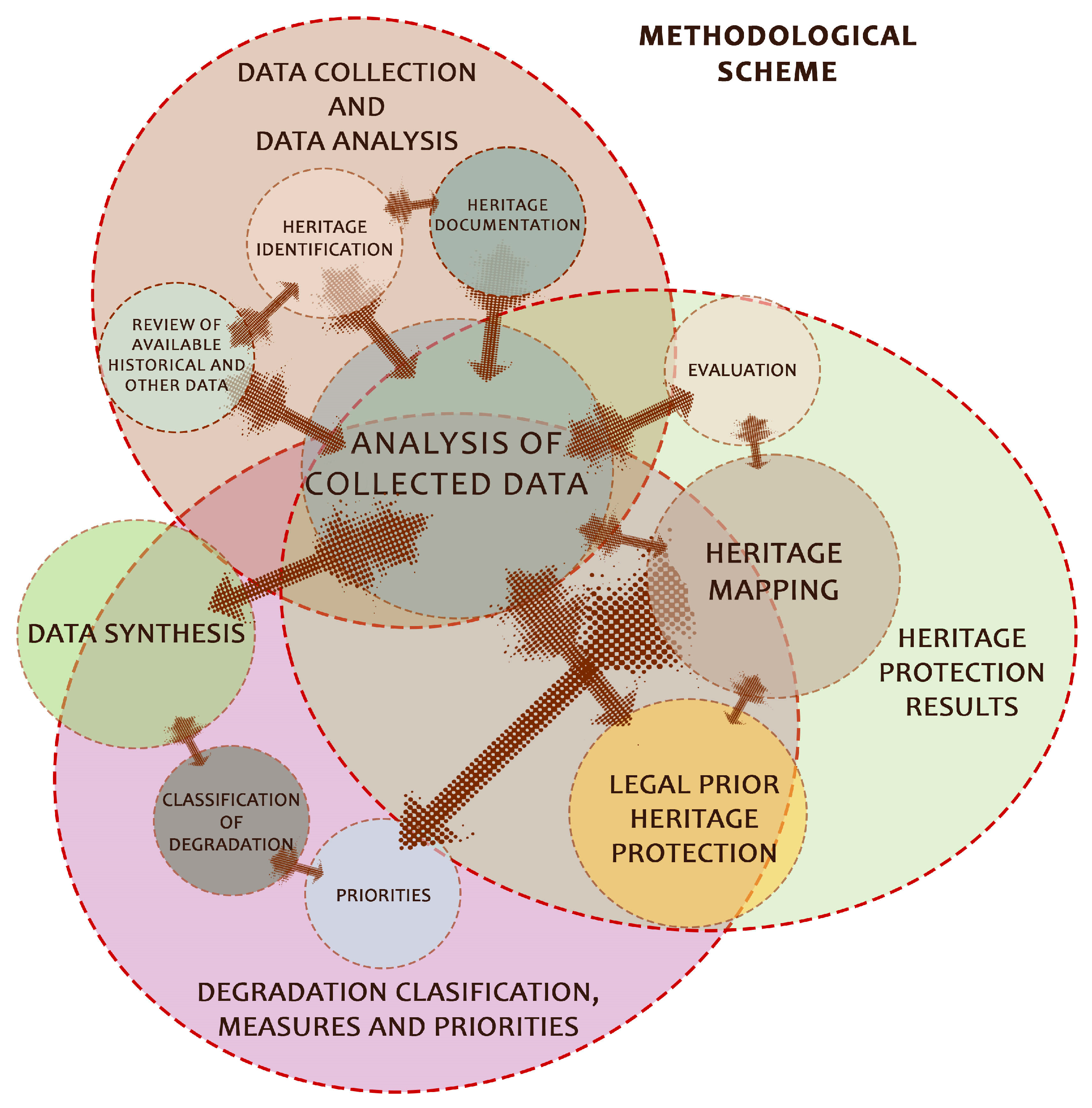
The methodological process comprises six main phases (
Figure 1):
Definition of the research area and sampling criteria;
Data collection through archival sources, field surveys, and digital documentation;
Evaluation of individual buildings;
Identification and classification of degradation types;
Spatial processing, data analysis, and synthesis of results to establish priorities for conservation interventions.
Formulation of recommendations for the preservation, enhancement, and integration of heritage into spatial and urban planning instruments.
The research area covers the historic core of Vlasotince, with a particular focus on the former commercial and artisan zone (the old bazaar-čaršija), which represents not only a historical section but also the social and administrative center of the town. This urban ensemble was selected due to its preserved urban morphology, the concentration of architecturally representative buildings from the late 19th and early 20th centuries, and the increasingly pronounced processes of neglect and inadequate interventions. A total of 84 buildings within the defined research area were included in the analysis. The selection of buildings was based on clearly defined criteria to ensure analytical consistency.
Buildings were included if they met at least two of the following conditions:
Located within the historically defined commercial core;
Construction period corresponding to the phase of formation and development of the historic urban fabric;
Preservation of original or partially retained architectural elements;
Contribution to the continuity of street fronts and ambient value of the area.
Buildings that have been completely reconstructed without any preserved historical elements, or that no longer contribute to the spatial coherence of the historic core, were excluded from the analysis. This purposive sampling allows for a focused assessment of the key elements of the historic urban landscape while maintaining a manageable scope for detailed documentation and evaluation.
Data collection was carried out using multiple complementary methods to ensure the reliability and depth of information. Archival research included historical maps, cadastral documentation from the late 19th and early 20th centuries, historical plans, previous and current planning acts, and archival photographic material, providing insight into the development and transformations of the urban structure. Field surveys were conducted to record the current physical condition of buildings, their architectural features, structural elements, and construction materials, as well as to document visible forms of degradation. Each building was documented using standardized field forms (architectural measurements accompanied by field and technical documentation, detailed photographic records, and descriptive reports), ensuring data consistency across the entire sample. Additionally, high-resolution 3D photogrammetric documentation was produced for selected buildings and entire street segments. Photogrammetry enabled precise geometric recording of facades and architectural details and served as both an analytical and visual tool, complementing field observations and value-based assessments.
The photogrammetric surveys formed the basis for a database of realistic 3D models of individual buildings and ensembles, enabling digital reconstruction of the current state of immovable cultural heritage. Public access to the 3D model database allows for further research and community participation [
28].
Mapping of buildings and spatial units was carried out partly in QGIS 3.44 and partly using GstarCAD2024 software. Statistical analyses were performed in Excel, where data were also visualized in the form of charts. Photogrammetric models were generated from a large set of photographs obtained through terrestrial photography with a camera and aerial photography using a DJI Mavic 2 Pro drone (DJI, Shenzhen, China). The collected photographs were processed using RealityCapture 1.5, an advanced photogrammetry and 3D reconstruction software. This tool automatically converts standard photographs and/or laser scans into precise, high-quality 3D models, maps, and orthophoto projections.
The evaluation and assessment of buildings were carried out using a value-based assessment model. Each building was analyzed according to pre-defined criteria encompassing architectural, historical, and urban values. Particular attention was given to individual buildings, which were considered in terms of architectural-artistic significance, historical and cultural context, memorial and identity-related value, functional schemes, community value, as well as urban significance.
The criterion of architectural and historical value in the context of the old bazaar (čaršija) of Vlasotince encompasses the assessment of the building’s period of construction and subsequent construction phases, which determine the historical continuity and typological evolution of the settlement. It also considers building typology, facade composition, structural and material characteristics, and the degree of authenticity. Historical value relates to the construction period, its connection with phases of urban development, and representativeness for local building traditions. Urban value was assessed based on a building’s contribution to street front continuity, spatial coherence, the identity of the historic core, and the recognizable city silhouette. The typological affiliation of buildings characteristic of the Vlasotince old bazaar (čaršija) was also examined, including street-oriented commercial houses and family houses located deeper within plots, enabling a coherent understanding of the historic urban landscape and its specific morphology.
The evaluation was based on expert judgment, supported by archival data, field observations, and comparative analysis within the study area. Assessment criteria and the evaluation scale were predefined and consistently applied to all buildings.
A potential limitation of this study lies in the value assessment of buildings, which is largely influenced by the expertise of the evaluators, as no software exists to process it, making the results subject to human error. However, such errors were minimized by establishing clear criteria prior to the start of the study, which were carefully considered and consistently applied throughout the evaluation process.
At the same time, the condition of the structure, facade surfaces, roof elements, and openings was examined, providing a clear understanding of the levels of degradation and the priority conservation needs. Particular attention was given to authentic architectural and spatial elements, such as wooden doors and windows, arched openings, stone plinths, and plaster finishes, which enhance the aesthetic and cultural value of the space [
29].
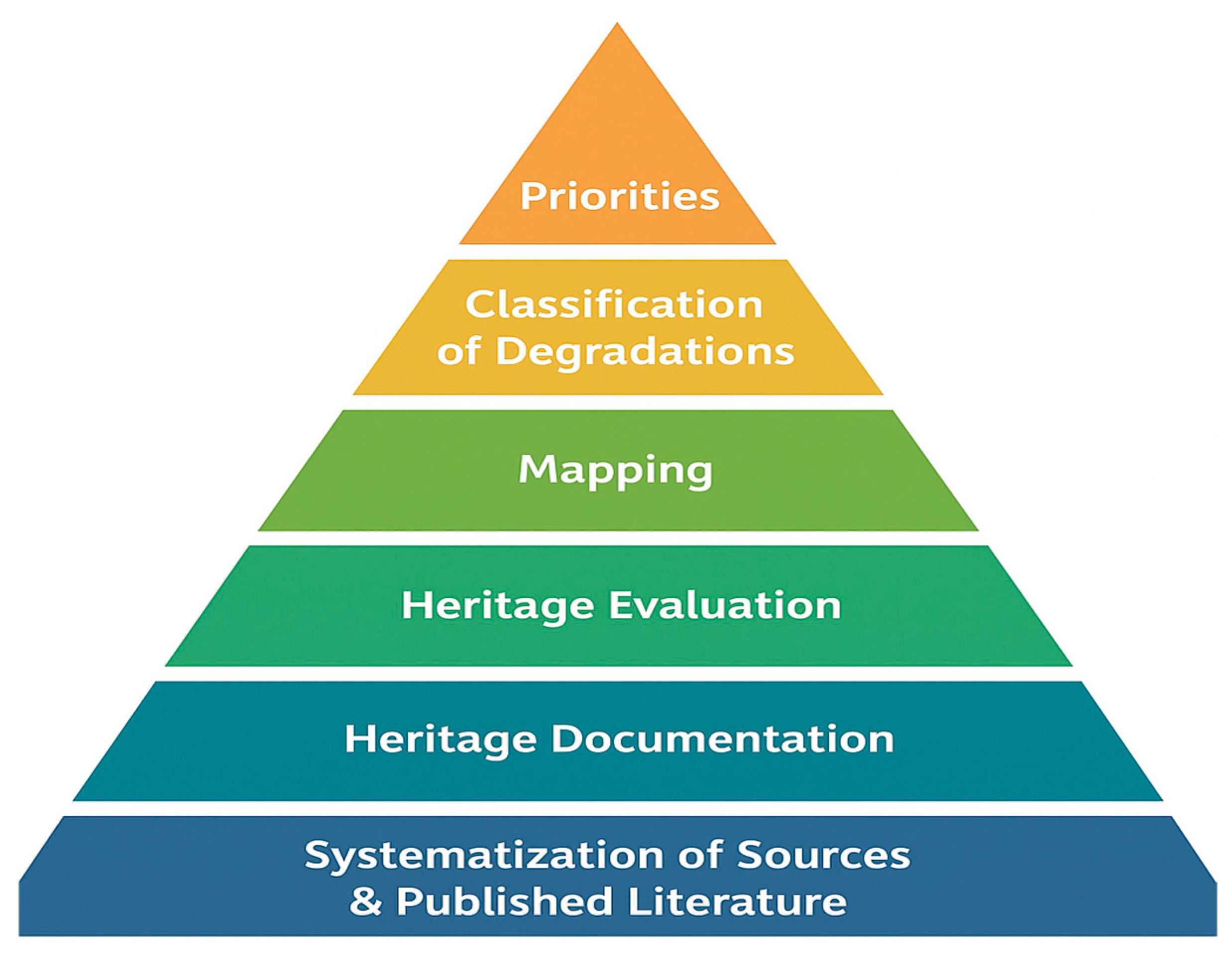
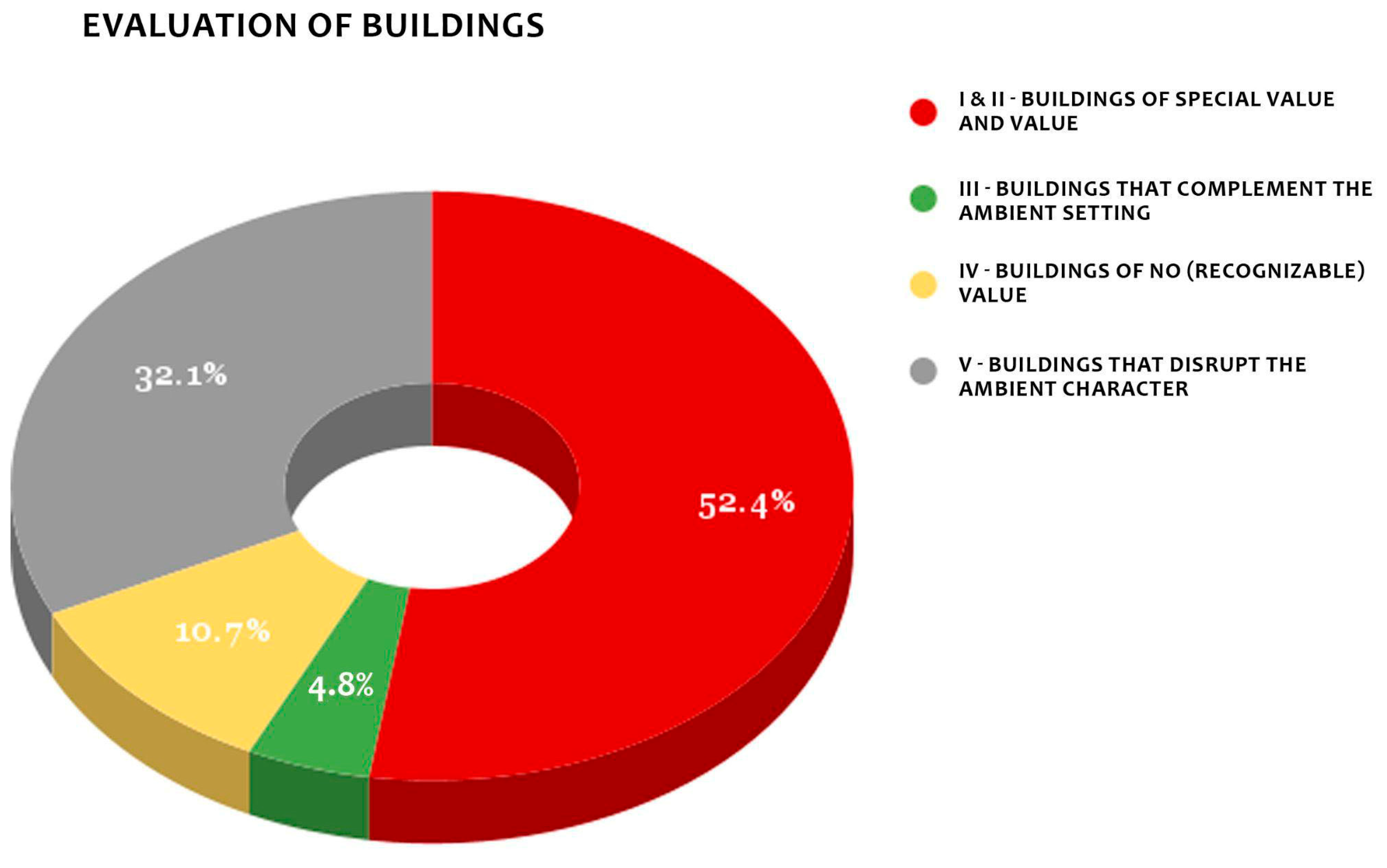
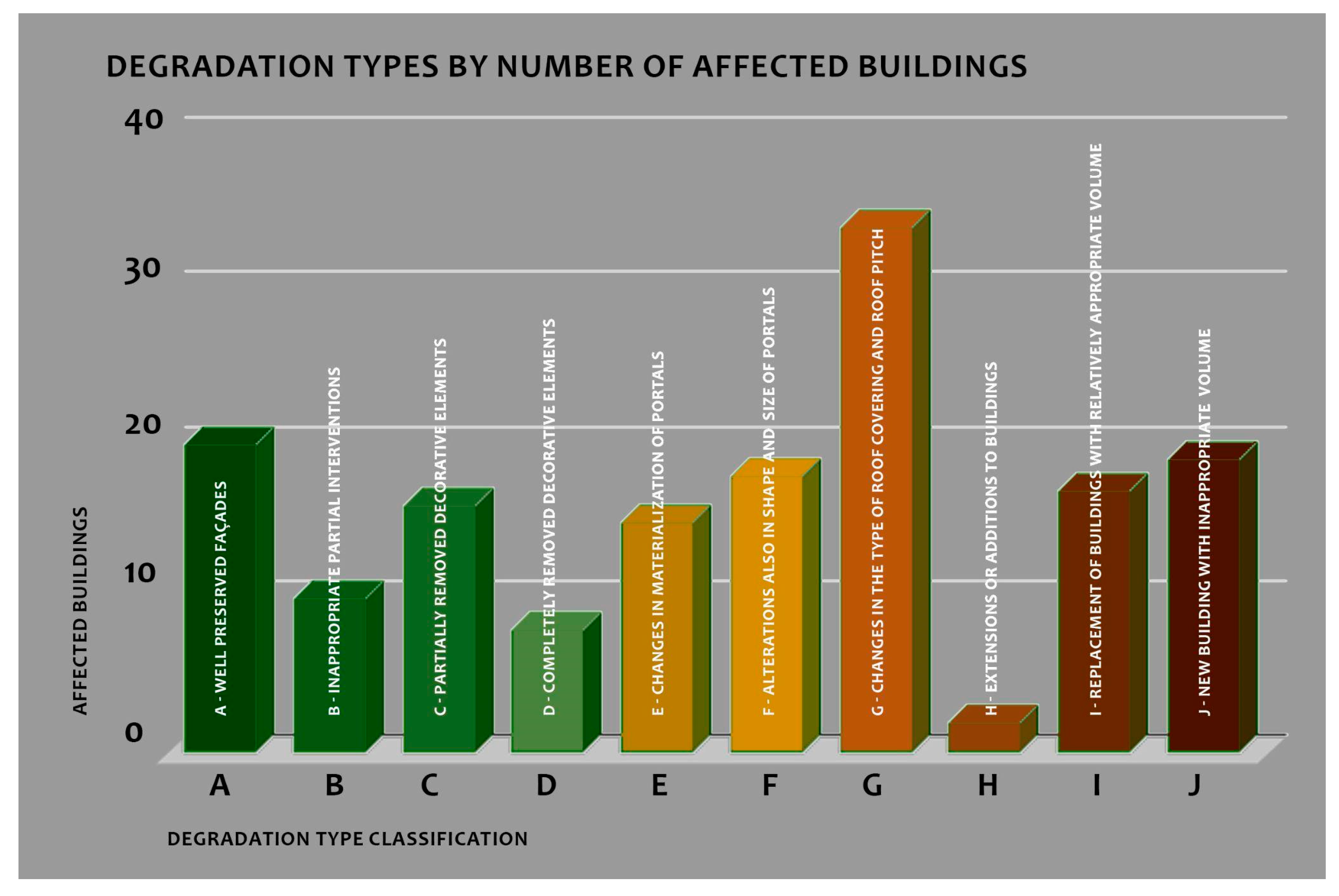
In the analysis of degradation, a typological system was applied to track various forms and degrees of deterioration of architectural and spatial values. Identified types of damage included material decay, inappropriate facade modifications, altered openings, changes to roof planes and coverings, volumetric alterations due to extensions, as well as functional changes affecting the external appearance of buildings. Each type of degradation was classified according to its impact on heritage values, distinguishing between reversible and irreversible interventions. This system facilitates the identification of buildings where values can be relatively easily restored, as well as those where degradation has resulted in a significant loss of authenticity. By linking types of degradation to value categories, precise mapping of the most vulnerable areas is enabled, allowing the identification of zones with priority conservation needs within the historic core (
Figure 2).
All collected data were systematized and processed within GIS and G-Star environments, enabling spatial visualization and analysis at the level of individual buildings. Attribute databases were created linking spatial elements with indicators of heritage value and degree of degradation, allowing thematic mapping and comparative analysis. The spatial analysis focused on identifying patterns, such as concentrations of value, the intensity of degradation, and zones of increased vulnerability. The integration of photogrammetric models into the spatial analytical framework further enhanced detailed facade analysis and precise documentation of the existing conditions.
Data validity was verified through cross-comparison of archival sources, field observations, and digital documentation. The proposed methodological framework can be applied to other small historic towns, with adjustments to criteria and the scope of research according to local conditions, ensuring its reproducibility and comparability.
3.2. Historical Context of the Study Area
Vlasotince is a small town in southern Serbia, located within the Jablanica District, which has so far not been significantly affected by depopulation. The municipality comprises a total of 47 settlements and has a population of approximately 26,000, of which around 15,000 reside in the town itself. Despite its small size, Vlasotince boasts an exceptionally valuable corpus of architectural heritage. However, until recently, this heritage was insufficiently treated and legally protected; apart from a few buildings designated as cultural monuments, most urban houses and palaces—although recorded in planning documentation—had not been professionally evaluated or protected as immovable cultural property.
The earliest written references to Vlasotince can be found in The Life of Saint Simeon, the 12th-century biography of Stefan Nemanja. Here, Vlasotince is referred to as Uska, denoting the area around the Vlasina River. Throughout history, the town appears in numerous records. Ottoman documents from 1516 mention it under the name Vlasotinac, noting that it was then a cultural and agricultural center. In the 16th century, it had around 600 inhabitants, and by the 1879 census, approximately 2600. Vlasotince was officially designated as a town in 1878 [
30].
After liberation from Ottoman rule, most affluent residents of Vlasotince sent their children to study in European countries, from where they brought back advanced ideas, marking the beginning of an intensive period of development for the town. The growth of Vlasotince was further supported by the development of the textile industry, trade, crafts, and viticulture [
31].
Regarding Vlasotince’s architectural stock, it gradually began to take shape at the end of the 18th century. By the mid-19th century, the town had developed as an elongated linear settlement with a commercial and craft-oriented character [
31]. This layout is still discernible today. By the late 19th century, European stylistic influences became evident in the representative buildings constructed during this period. In the early 20th century, and later between the two world wars—when conditions for architectural development were established—significant construction activity took place, accompanied by greater stylistic diversity. In addition to academicism, two entirely distinct styles emerged: the Serbian-Byzantine, or national style, and Art Nouveau (Secession) [
32]. Family residential and commercial buildings constructed in the first decade of the 20th century are characterized by massiveness, symmetry, representativeness, and academic-style design [
31].
The study analyzed buildings constructed from the late 19th century to the first half of the 20th century, corresponding to the phase of formation and development of the historic urban core of Vlasotince.
3.3. Architectural Heritage of the Study Area
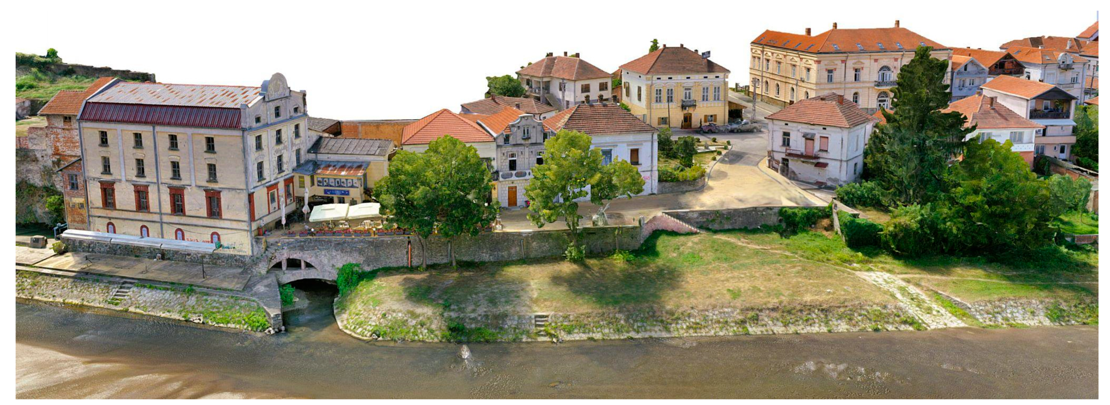
Over the centuries, Vlasotince developed as a town with a strong commercial, craft, and architectural identity, with each historical period—the Ottoman era, the post-liberation period, the interwar years, and the postwar period—clearly reflected in the city’s structure. This stratification is evident in the layout of the old bazaar (čaršija), house typologies, urban lines, and numerous buildings that bear the marks of different eras. Along the main street are rows of craft workshops and shops with narrow facades and typically deep plots, as well as multi-story bourgeois houses of architectural and artistic value, showcasing skilled craftsmanship. The partially preserved old trading bazaar (čaršija) in the town center represents the urban and living core of the settlement, densely built and retaining inherited specificities (
Figure 3).
To understand the layering of space and the character of the heritage embedded in Vlasotince’s urban fabric, it was necessary to examine its spatial organization and natural conditions, as well as the historical processes that shaped its urban development. Understanding these layers is essential for correctly interpreting the architectural heritage and defining its values in a contemporary context.
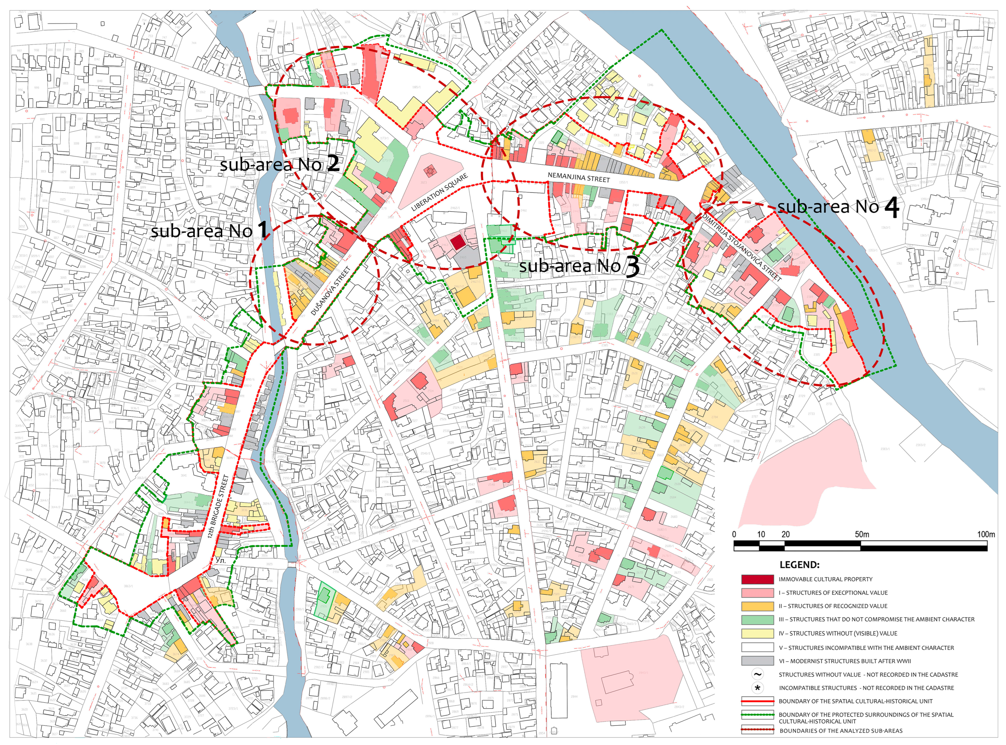
In 2023, extensive research was conducted on Vlasotince’s architectural stock to identify and define inherited values. This involved mapping and evaluating buildings across the wider area, and, based on detailed analyses and the higher concentration of structures with notable heritage characteristics, a spatial cultural-historical unit—the Old Čaršija—was delineated. It encompasses Dragoljub Petković Square, 12th Brigade Street and Dušanova Street, as well as Liberation Square and Marka Oreškovića, AVNOJ, Ive Lole Ribara, Nemanjina, Dimitrija Stojanovića, Njegoševa, and Vuka Karadžića Streets (
Figure 4) [
8].
To facilitate the assessment and evaluation of the identified historic unit, as well as to define measures for technical protection, the area was divided into several smaller ambient units, or groups of valuable buildings. These are located along Dušanova Street, Liberation Square, Marka Oreškovića Street, Ive Lole Ribara Street, Nemanjina Street, and Dimitrija Stojanovića Street near the Old Mill, and are presented below.
3.3.1. Sub-Area No 1.—Dušanova Street
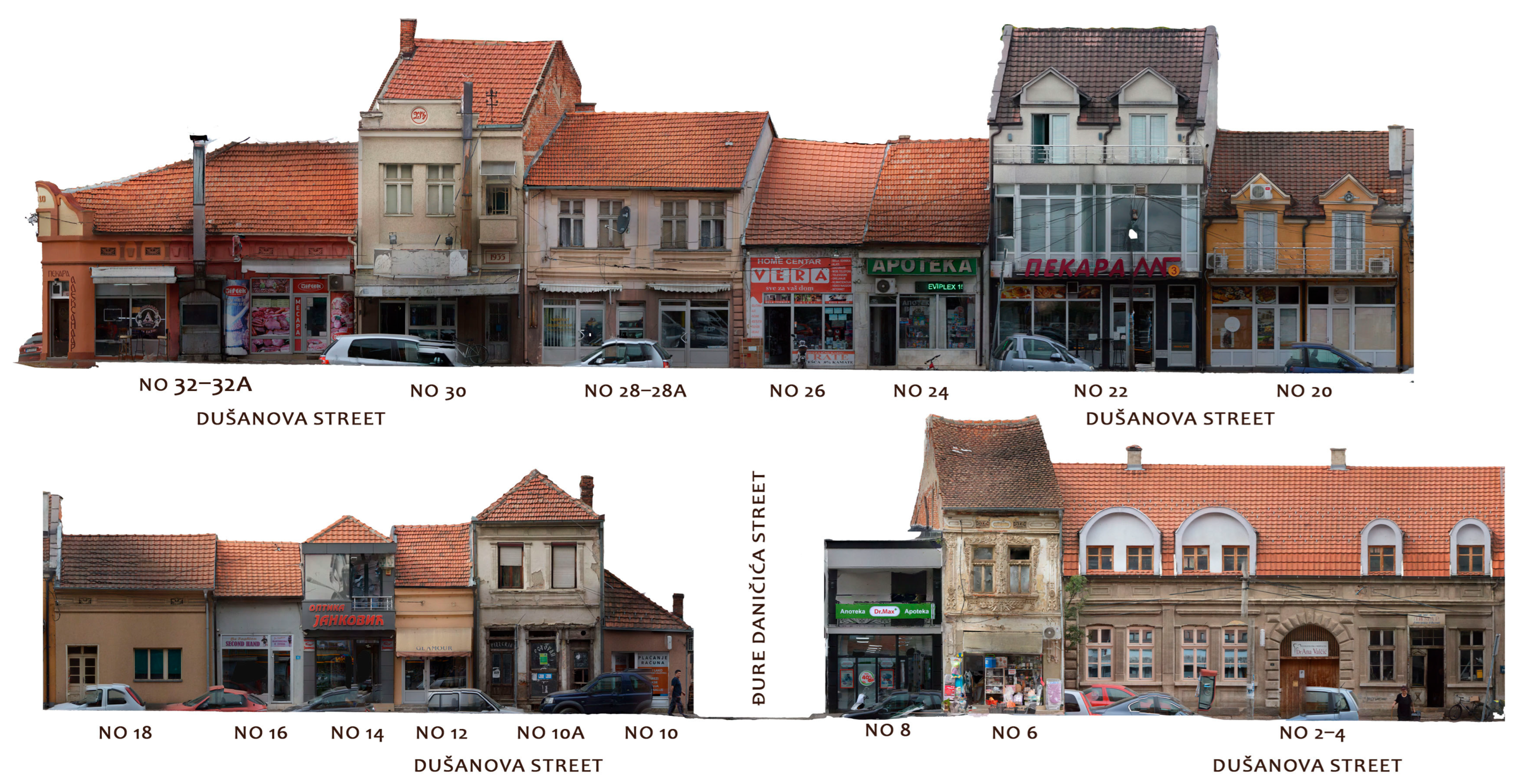
Dušanova Street represents the central part of the Old Čaršija, with the remnants of architectural heritage preserved only on the even-numbered side, while buildings on the odd-numbered side were completely demolished during the implementation of total reconstruction plans for the city center and the construction of multi-story buildings in the second half of the 20th century. The houses on the even-numbered side of Dušanova Street in this section of the Old Čaršija are modest in appearance, either single- or two-story, arranged within a block bordered by Đura Daničić Street, which runs along Peškina Valley. The composition of this subunit consists of two sections of Dušanova Street, divided by the passage of Đura Daničić Street. This part of the unit is among the most degraded areas of the Old Čaršija. The disharmony of the street row is accentuated by buildings of varying heights, numbers of floors, and facade treatments. Notable buildings in this subunit include the Paraskeva Bojković House, the Zaharija Hadži Stamenković House—a structure of high architectural value and one of the few with Art Nouveau motifs in Vlasotince—the Tasa Valčić House, with exceptional documentary and historical significance, among others.
3.3.2. Sub-Area No 2.—Liberation Square
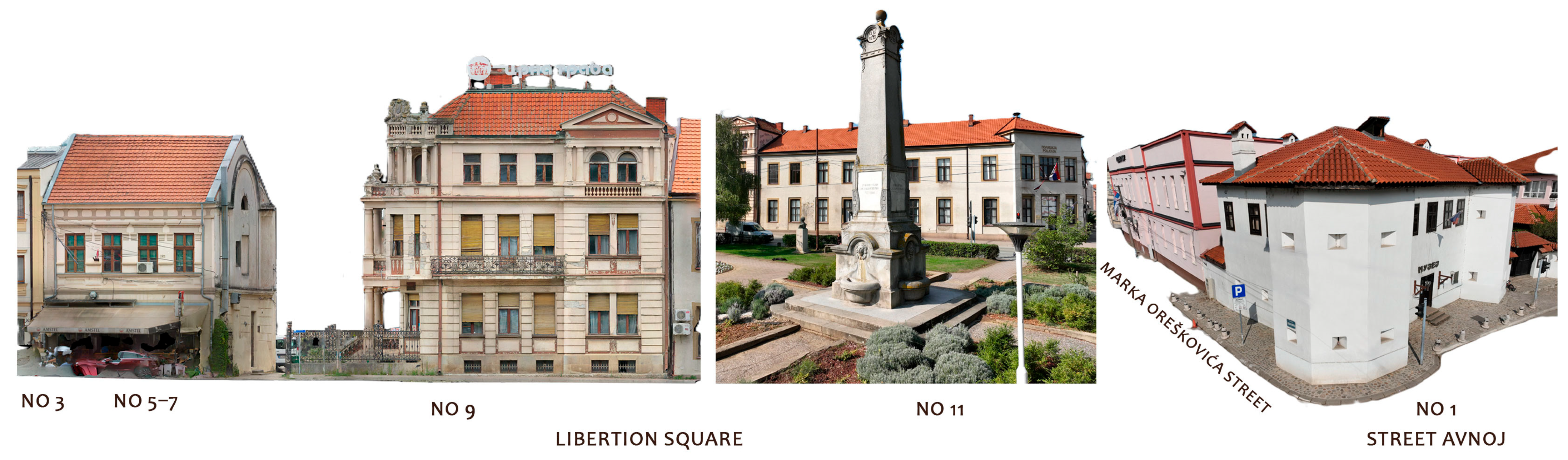
Liberation Square is a spontaneously formed town square in the center of Vlasotince, originally serving as the main marketplace. The square has a triangular shape, with the former main market located at its center, around which the urban core and central town square developed spontaneously, featuring a fountain and a monument to fallen soldiers in the form of an obelisk. Over time, significant public buildings were constructed around the former market, forming the urban core of Vlasotince. In addition to public institutions—such as the Old Municipality building, the District Administration, and the People’s House—the marketplace was surrounded by numerous single- or two-story private buildings with mixed public–private functions, including hospitality, commercial-craft activities, and residential use, forming the town’s commercial-craft čaršija.
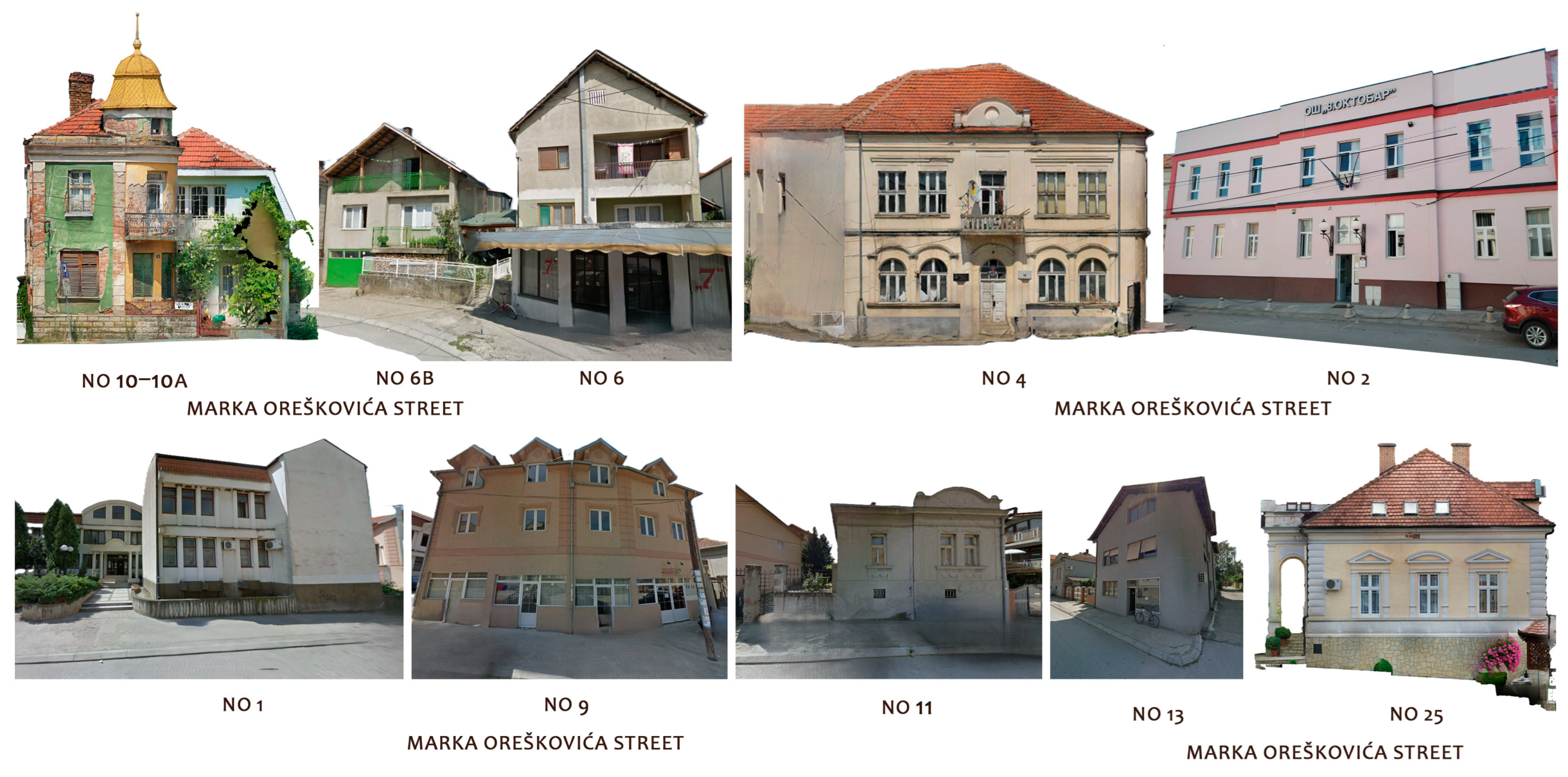
Marka Oreškovića Street represents a small residential branch of the Old Čaršija in Vlasotince. It is directly connected to Liberation Square, forming an integral unit that continues the spatial fabric of the čaršija. In addition to characteristic residential houses with diverse architectural treatments—such as the corner house with a dome by Miladin Đorđević and the monumental Gligorija Parunović House, set in spacious courtyards with abundant greenery—significant public buildings are located at the corner with Liberation Square, including the Police building, the Regional Museum building, the complex of the Primary School, and the former People’s (Sokol) House.
3.3.3. Sub-Area No 3.—Nemanjina Street
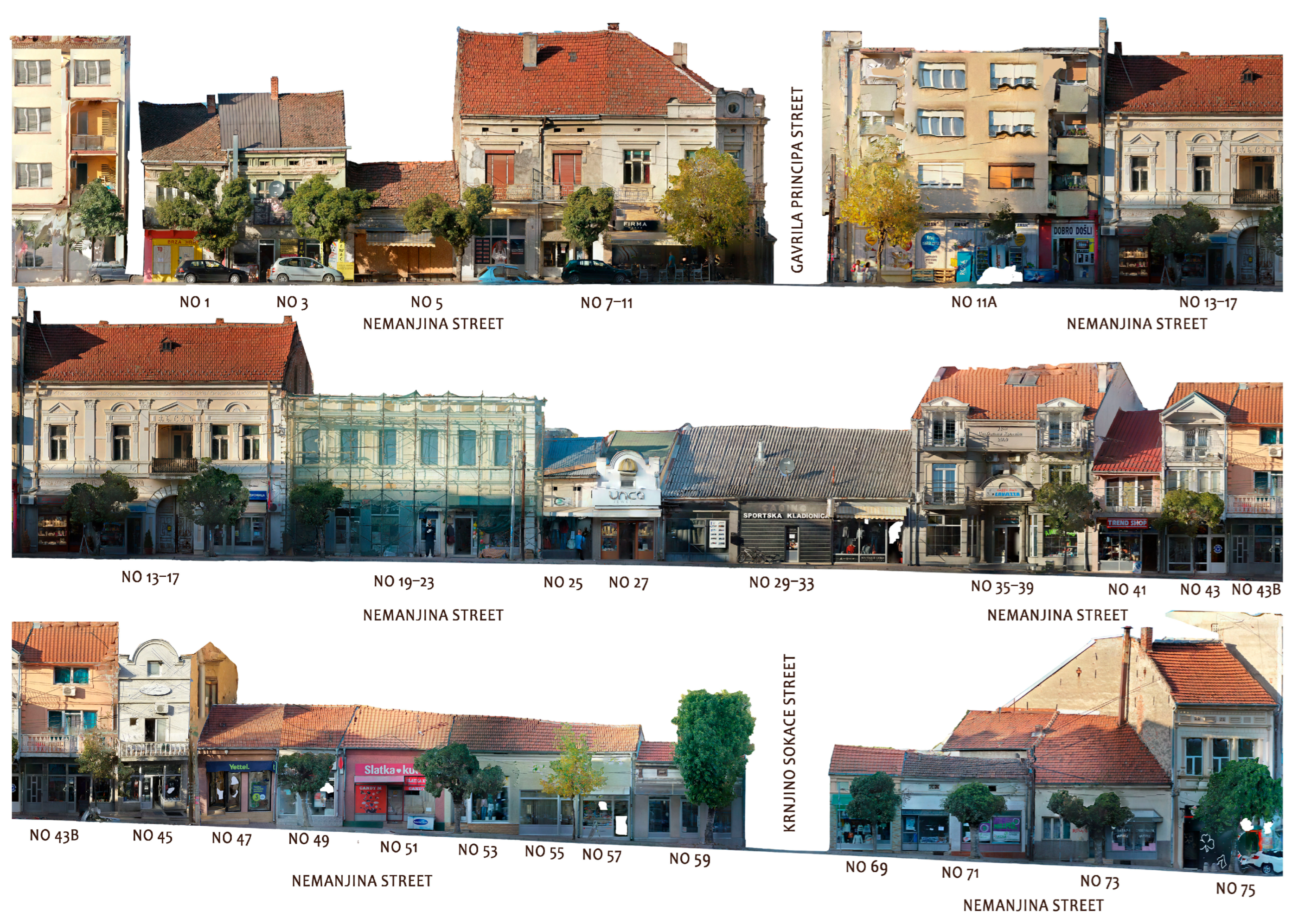
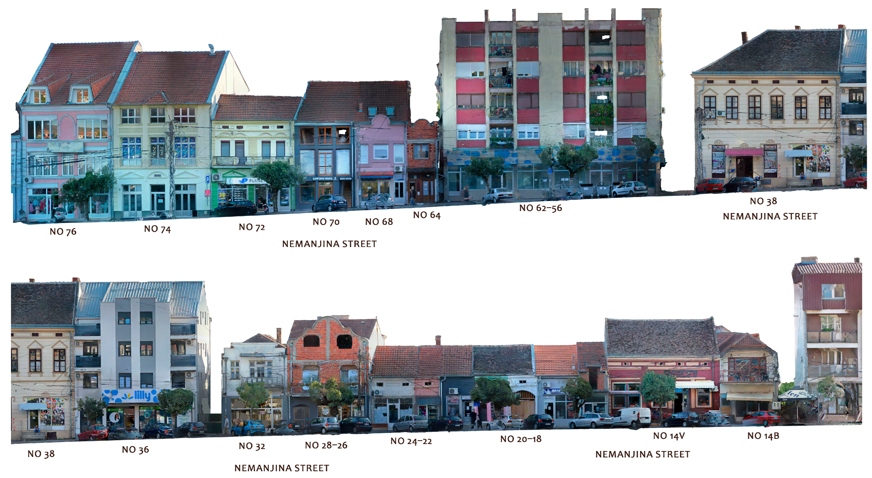
Nemanjina Street constitutes the largest part of the observed spatial unit. Along this street, craft workshops and shops were arranged, typically with a residential upper floor. Over time, the population density led to the construction of a few four-story buildings. The street also functions as the town’s promenade, becoming a pedestrian zone between 6 p.m. and 10 p.m.
The odd-numbered side of the street is quite disharmonious, primarily due to varying building heights and diverse architectural styles resulting from construction across different periods. The most prominent buildings on the odd side include the two-story corner house of Kriste Bošković, the Golub Aranđelović Belja House with its highly decorative facade, and the Ilija Krainčanić House.
On the even-numbered side of Nemanjina Street, in the section that has preserved architectural heritage, the street begins with Ilija Krainčanić’s tavern and ends with Uroš Valčić two-story building. The aforementioned tavern and several adjacent establishments represent remnants of the old urban matrix and architecture, while the subsequent buildings exhibit characteristics of a broken row. This block primarily consists of lower structures with gable roofs and roughly uniform roof cornices.
3.3.4. Sub-Area No 4.—Dimitrija Stojanovića and Njegoševa Street
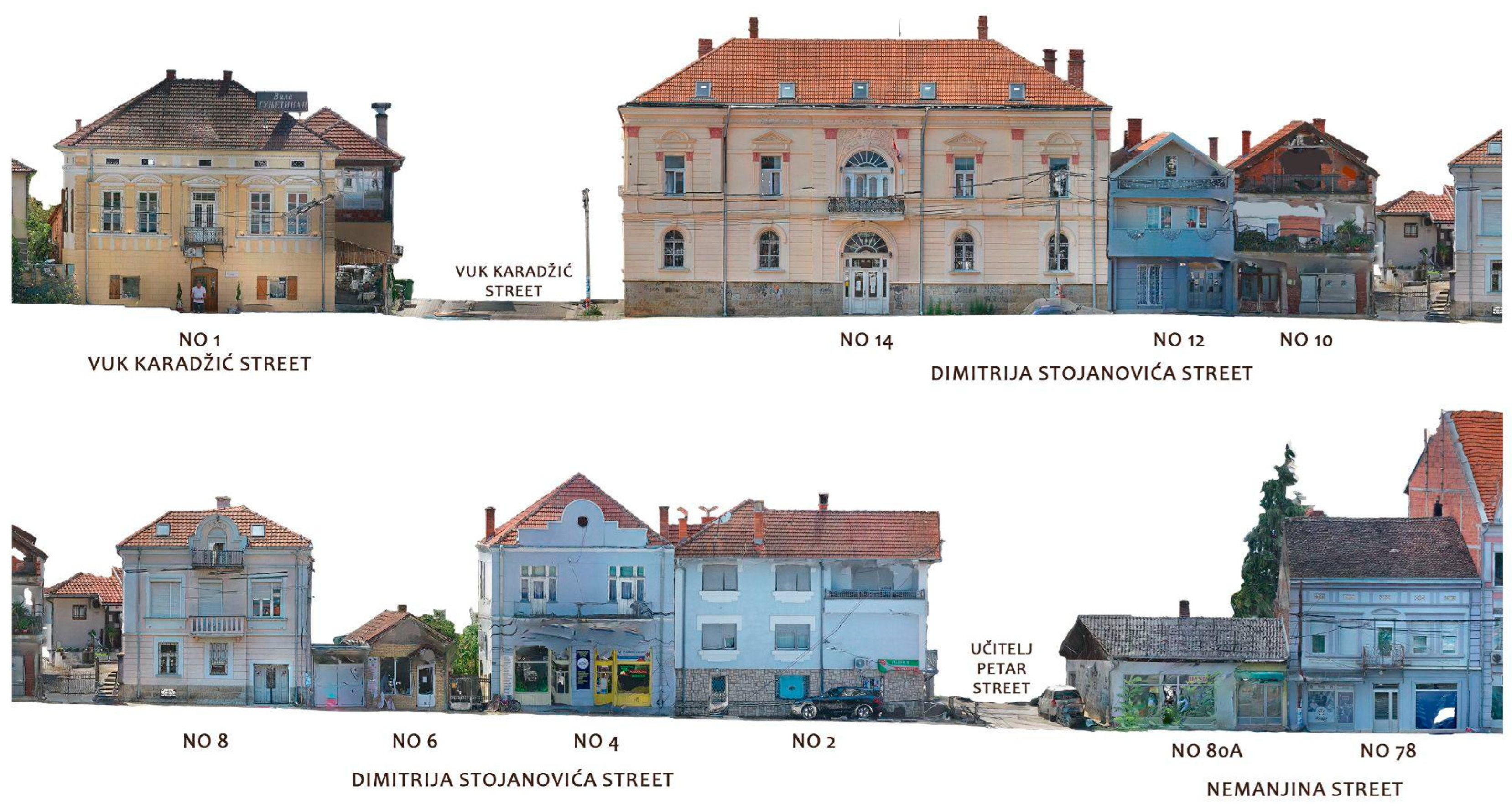
Dimitrija Stojanovića Street represents a direct continuation of Nemanjina Street, which is further extended by Njegoševa Street. This unit is characterized by buildings that vary in form and spatial rhythm, with a rather irregular and inconsistent arrangement and size of houses. It is the part of Vlasotince with the highest concentration of architectural heritage and is intensively used as the most attractive section of the Old Čaršija.
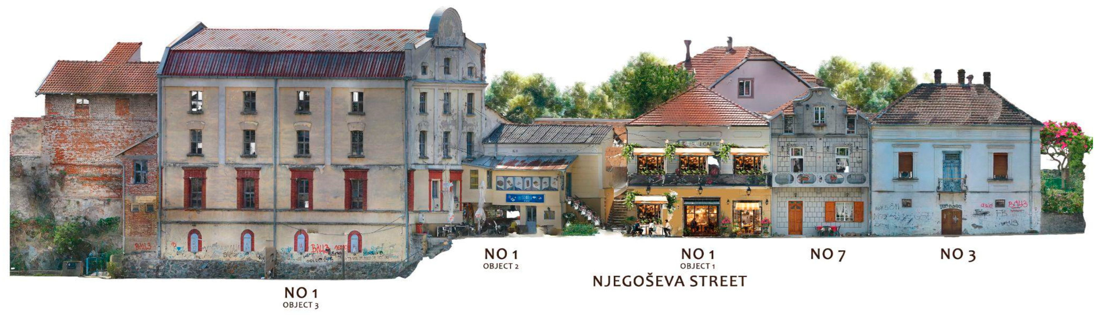
In this subunit, monumental buildings dominate, which remain symbolic landmarks of the town today: the old Popović Mill, accompanied by several houses oriented toward the river; the representative Stamenko Milošević House, now functioning as a restaurant; and the monumental Petar Popović House, currently housing the Social Services Center. Buildings located further along this street do not match the height of its roofline, proportions, or number of stories. A similar situation occurs along Njegoševa Street, with differences due to terrain configuration. This section of the town possesses significant recreational, tourist, and commercial potential.






 ,
,