Wave Modeling for the Establishment Potential Area of Offshore Aquaculture in Indonesia
Abstract
:1. Introduction
2. Study Area
3. Materials
4. Methods
4.1. Hydrodynamic Model
| d | m | depth below some horizontal plane of reference (datum) |
| Gξξ | m | coefficient used to transform curvilinear to rectangular coordinates |
| Gηη | m | coefficient used to transform curvilinear to rectangular coordinates |
| Q | 1/s | global source or sink per unit area |
| qin | 1/s | local source per unit volume |
| qout | 1/s | local sink per unit volume |
| U | m/s | depth-averaged velocity in ξ-direction |
| u | m/s | flow velocity in the y- or ξ-direction |
| V | m/s | depth-averaged velocity in η-direction |
| v | m/s | flow velocity in the x- or η-direction |
| ξ, η | horizontal, curvilinear co-ordinates | |
| ζ | m | water level above some horizontal plane of reference (datum) |
4.2. Wave Modeling
4.2.1. Basic Equation
- (x,y) = complex surface elevation function, from which the wave height can be estimated
- = wave frequency under consideration (in radians/second)
- C(x,y) = phase velocity =
- Cg (x,y) = group velocity =
- with
- k(x,y) = wave number (=2π/L), related to the local depth d(x,y) through the linear dispersion relation:
- = gk tanh (kd)
4.2.2. Setup Boundary Condition
5. Results and Discussion
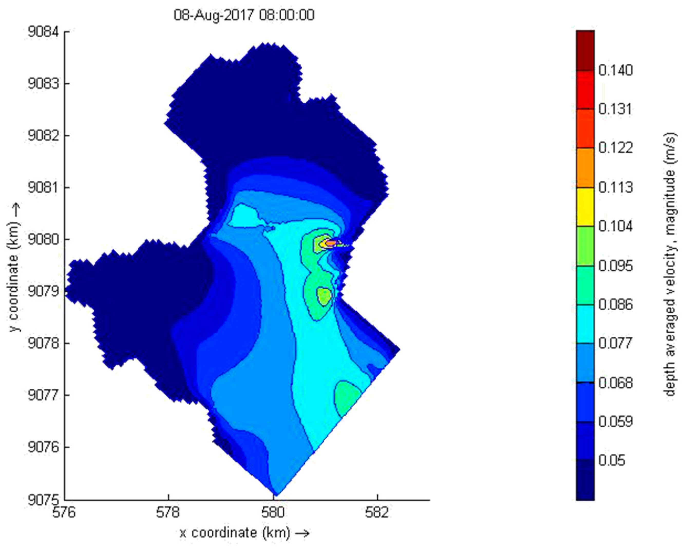
5.1. Hydrodynamic Modelling
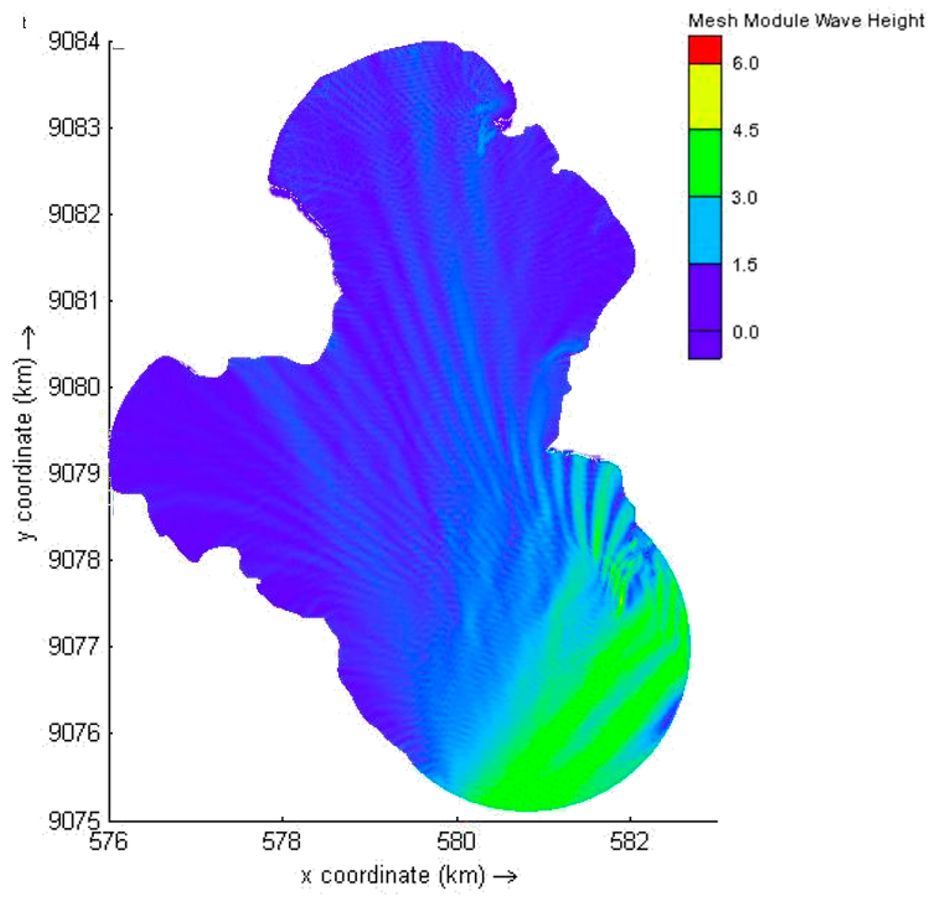
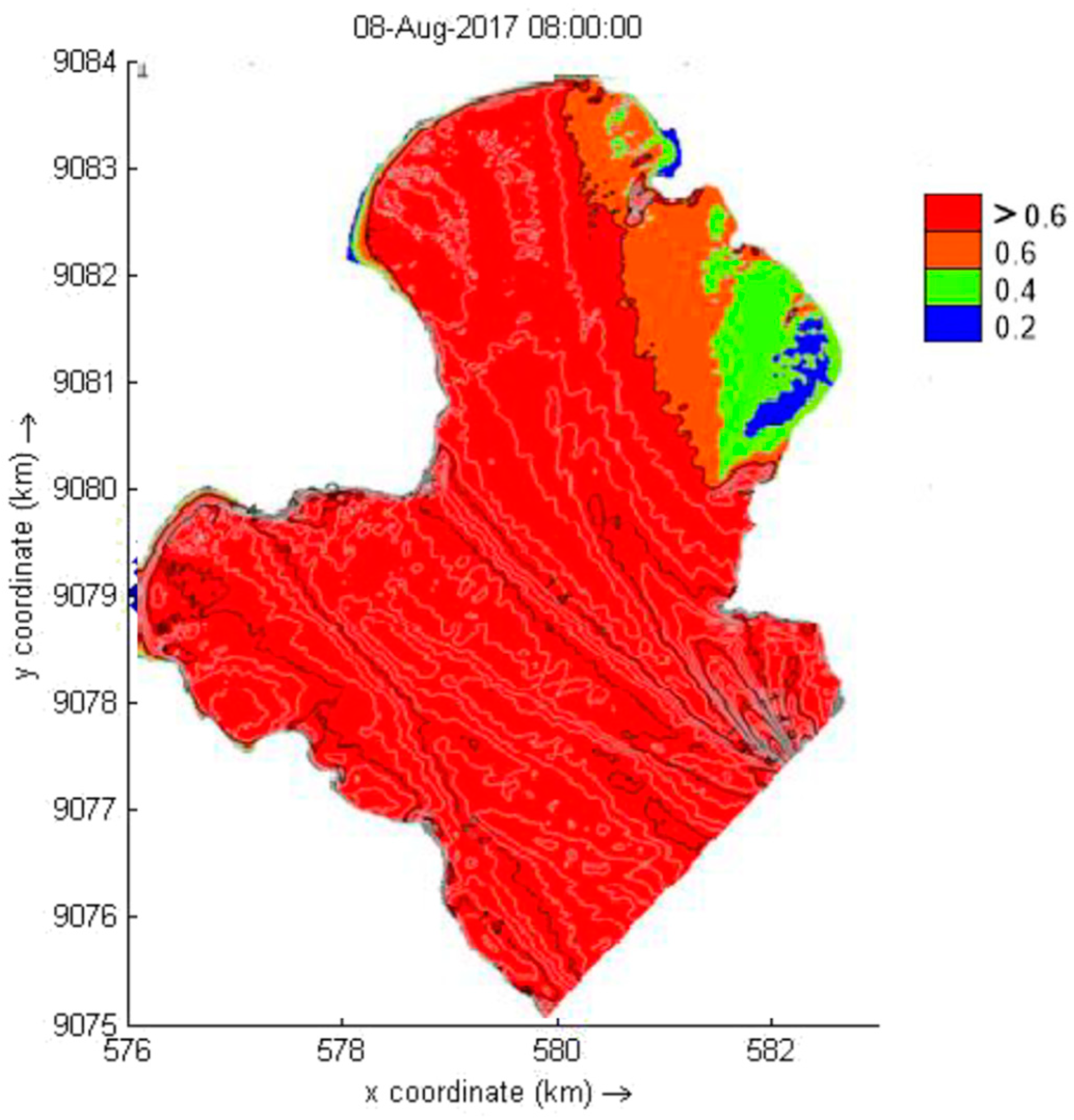
5.2. Wave Model
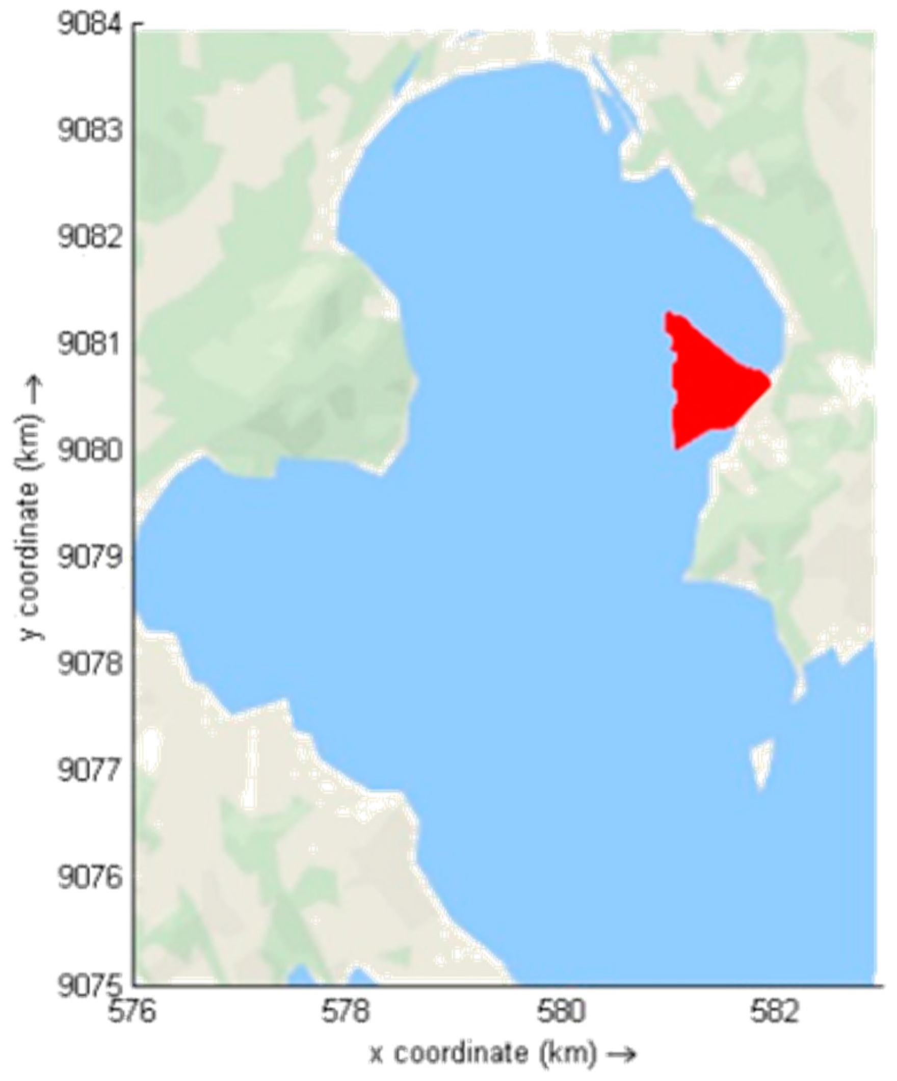
5.3. Suitability Location Using Superimpose Analysis
6. Conclusions
Author Contributions
Funding
Conflicts of Interest
References
- Ministry of Marine Affairs and Fisheries. Center of Data and Statistics, 2017; Ministry of Marine Affairs and Fisheries: Jakarta, Indonesia, 2018.
- Food and Agriculture Organization of the United States; World Bank. The State of World Fisheries and Aquaculture 2016; Contributing to Food Security and Nutrition for All; Food Agric Organ UN: Rome, Italy, 2016. [Google Scholar]
- Food and Agriculture Organization of the United States; World Bank. Aquaculture Zoning, Site Selection and Area Management under the Ecosystem Approach to Aquaculture A Handbook; Contributing to Food Security and Nutrition for All; Food Agric Organ UN: Rome, Italy, 2017. [Google Scholar]
- Food and Agriculture Organization. The State of World Fisheries and Aquaculture 2020; Sustainability in Action; FAO: Rome, Italy, 2020. [Google Scholar] [CrossRef]
- Duarte, C.M.; Holmer, M.; Olsen, Y.; Soto, D.; Marbà, N.; Guiu, J.; Black, K.; Karakassis, I. Will the oceans help feed humanity? Bioscience 2009, 59, 967–976. [Google Scholar] [CrossRef]
- Zikra, M.; Haryo, D.A.; Billy, M. Site selection of aquaculture location in Indonesia Sea. Ecol. Environ. Conserv. 2020, 26, S8–S17. [Google Scholar]
- Perez, O.M.; Telfer, T.C.; Ross, L.G. Geographical information systems-based models for offshore floating marine fish cage aquaculture site selection in Tenerife, Canary Islands. Aquac. Res. 2005, 36, 946–961. [Google Scholar] [CrossRef]
- Bostick, K. Aquaculture in the Ecosystem. In NGO Approaches to Minimizing the Impacts of Aquaculture: A Review; Holmer, M., Black, K., Duarte, C.M., Marbà, N., Karakassis, I., Eds.; Springer: Dordrecht, The Netherlands, 2008. [Google Scholar]
- Haryo, D.A.; Billy, M.; Zikra, M. The Usage of Geographical Information System in the Selection of Floating Cages Location for Aquaculture at Prigi Bay, Trenggalek Regency, East Java. IOP Conf. Ser. Earth Environ. Sci. 2018, 135, 012023. [Google Scholar]
- Aguilar-Manjarrez, J.; Crespi, V. National Aquaculture Sector Overview Map Collection. User Manual/Vues Générales du Secteur Aquacole National (NASO); Manuel de l’utilisateur; FAO: Rome, Italy, 2013; p. 65. Available online: www.fao.org/docrep/018/i3103b/i3103b00.htm (accessed on 20 November 2020).
- Ryan, J.; Mills, G.; Maguire, D. Farming the Deep Blue; Marine Institute: Dublin, Ireland, 2004; p. 67. [Google Scholar]
- Beveridge, M. Cage Aquaculture, 3rd ed.; Blackwell Publishing: Ames, IA, USA, 2004. [Google Scholar]
- Radiarta, I.N. Mapping the Feasibility of Land Cultivation Sea Fish in District Moro, Riau Islands: With the Geographical Information System Approach. J. Aquac. Res. 2006, 1, 291–302. [Google Scholar]
- Roelvink, J.A.; Van Banning, G.K.F.M. Design and development of Delft3D and application to coastal morphodynamics. In Proceedings of the Hydroinformatics ’94 Conference, Delft, The Netherlands, 19–23 September 1994. [Google Scholar]
- Deltares. Delft3D-FLOW Manual; Boussinesqweg: Delft, The Netherlands, 2014. [Google Scholar]
- Elias, E.P.L.; Walstra, D.-J.; Dano, J.A. Roelvink and Marcel Stive, Hydrodynamic Validation of Delft3D with Field Measurements at Egmond. In Proceedings of the 27th International Conference on Coastal Engineering (ICCE), Sydney, Australia, 16–21 June 2001. [Google Scholar]
- Demirbilek, Z.; dan Panchang, V. CGWAVE: A Coastal Surface Water Wave Model of the Mild Slope Equation; Army Corps of Engineers: Washington, DC, USA, 1998.


| Parameter | Coastal | Off the Coast | Offshore |
|---|---|---|---|
| Location | 500 m from the coast | 500 m–3 km | >3 km open ocean |
| Depth | 10 m depth | 10 m < depth < 50 m | 50 m depth< |
| Wave Height | Hs < 1 m | Hs < 3–4 m | Hs > 5 m |
| Site Class | 1 | 2 | 3 | 4 |
|---|---|---|---|---|
| Conventional description | Sheltered inshore site | Semi-exposed inshore site | Exposed offshore site | Open-ocean offshore site |
| Cage type used | Surface gravity | Surface gravity | Surface gravity, anchor tension | Surface gravity, surface rigid, anchor tension, submerged gravity, submerged rigid |
| Environmental Parameter | Unit | Highly Suitable | Suitable | Unsuitable |
|---|---|---|---|---|
| Bathymetry | m | 10–20 | 20–30 | <10 >30 |
| Current | m/s | 0.05–0.15 | 0.15–0.35 | >0.35 <0.05 |
| Wave Height | m | <0.20 | 0.20–0.40 | >0.40 |
| No | Parameters | |
|---|---|---|
| 1 | Delft3D model setup | |
| Model configuration | 2DH (depth-averaged) | |
| Horizontal grid resolution | 20 m × 20 m | |
| Number of grid elements | 9760 | |
| Meteorological forcing | astronomical tidal forcing, wind data | |
| 2 | Delft3D parameters | |
| Time step | 60 s | |
| Chézy roughness coefficient | 65 m1/2/s | |
| Horizontal eddy viscosity | 1 m2/s | |
| Horizontal eddy diffusivity | 1 m2/s | |
| Threshold depth | 0.1 m |
| Month | Wave Height (m) | Wave Period (s) |
|---|---|---|
| January | 3.68 | 9.95 |
| February | 3.89 | 10.82 |
| March | 3.54 | 17.68 |
| April | 2.73 | 15.53 |
| May | 3.17 | 16.91 |
| June | 3.54 | 17.68 |
| July | 3.86 | 20.13 |
| August | 3.59 | 18.85 |
| September | 2.88 | 15.62 |
| October | 2.52 | 15.62 |
| November | 2.22 | 11.28 |
| December | 2.40 | 12.23 |
Publisher’s Note: MDPI stays neutral with regard to jurisdictional claims in published maps and institutional affiliations. |
© 2020 by the authors. Licensee MDPI, Basel, Switzerland. This article is an open access article distributed under the terms and conditions of the Creative Commons Attribution (CC BY) license (http://creativecommons.org/licenses/by/4.0/).
Share and Cite
Zikra, M.; Armono, H.D.; Pratama, F. Wave Modeling for the Establishment Potential Area of Offshore Aquaculture in Indonesia. Fluids 2020, 5, 229. https://doi.org/10.3390/fluids5040229
Zikra M, Armono HD, Pratama F. Wave Modeling for the Establishment Potential Area of Offshore Aquaculture in Indonesia. Fluids. 2020; 5(4):229. https://doi.org/10.3390/fluids5040229
Chicago/Turabian StyleZikra, Muhammad, Haryo Dwito Armono, and Fahrizal Pratama. 2020. "Wave Modeling for the Establishment Potential Area of Offshore Aquaculture in Indonesia" Fluids 5, no. 4: 229. https://doi.org/10.3390/fluids5040229
APA StyleZikra, M., Armono, H. D., & Pratama, F. (2020). Wave Modeling for the Establishment Potential Area of Offshore Aquaculture in Indonesia. Fluids, 5(4), 229. https://doi.org/10.3390/fluids5040229


