Spatiotemporal Evolution of Urban Expansion Using Landsat Time Series Data and Assessment of Its Influences on Forests


 ,
,
Abstract
1. Introduction
2. Study Area and Datasets
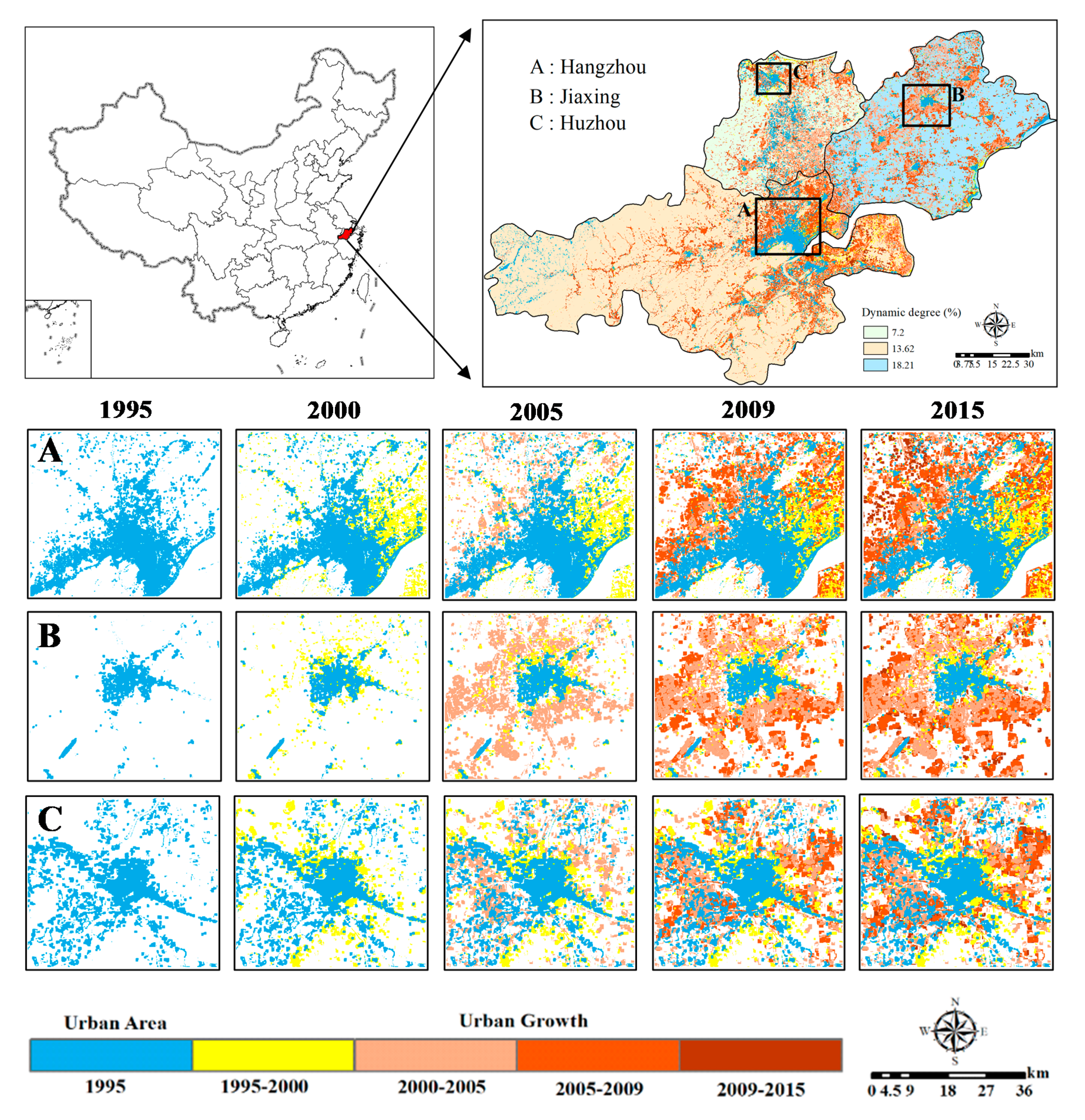
2.1. Study Area
2.2. Datasets and Processing
3. Study Methodology
3.1. C5.0 Decision Tree
3.2. Construction of the Decision Tree
3.3. Evalution of Urban Expansion
3.4. Land Use Prediction
4. Results and Analysis
4.1. Classification Decision Trees
4.2. Classification Result and Verification Accuracy
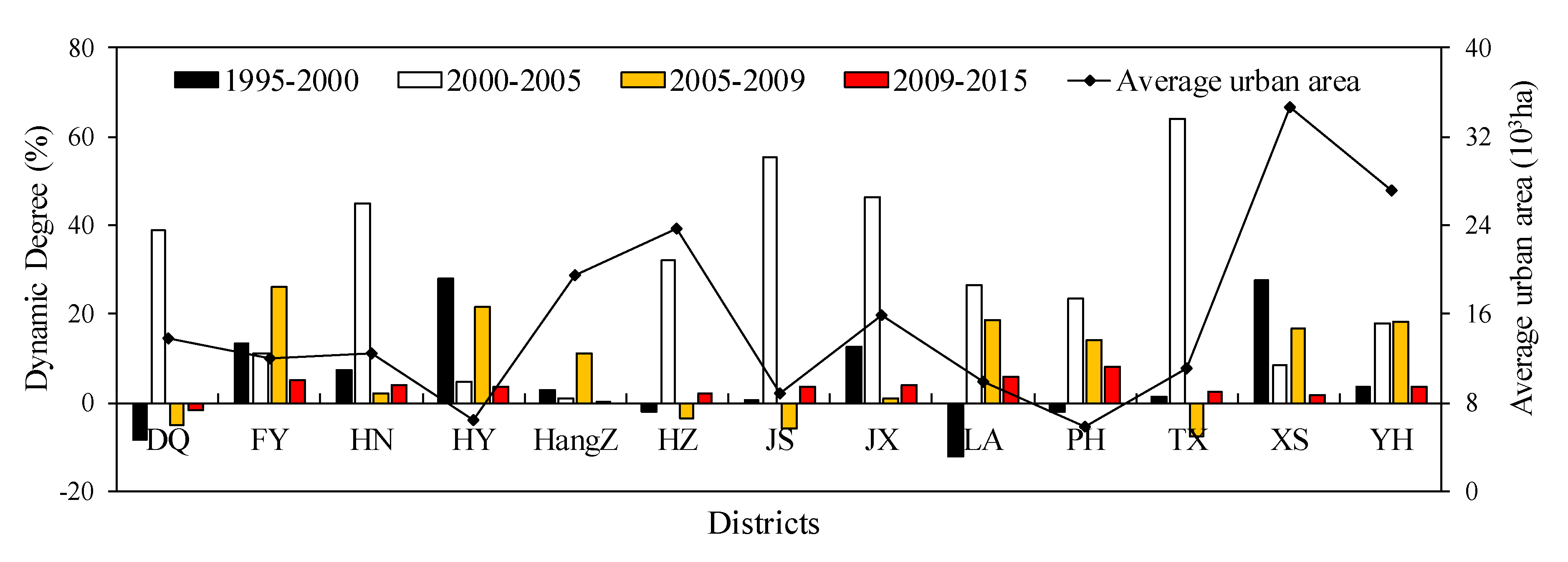
4.3. Analysis of Urban Expansion
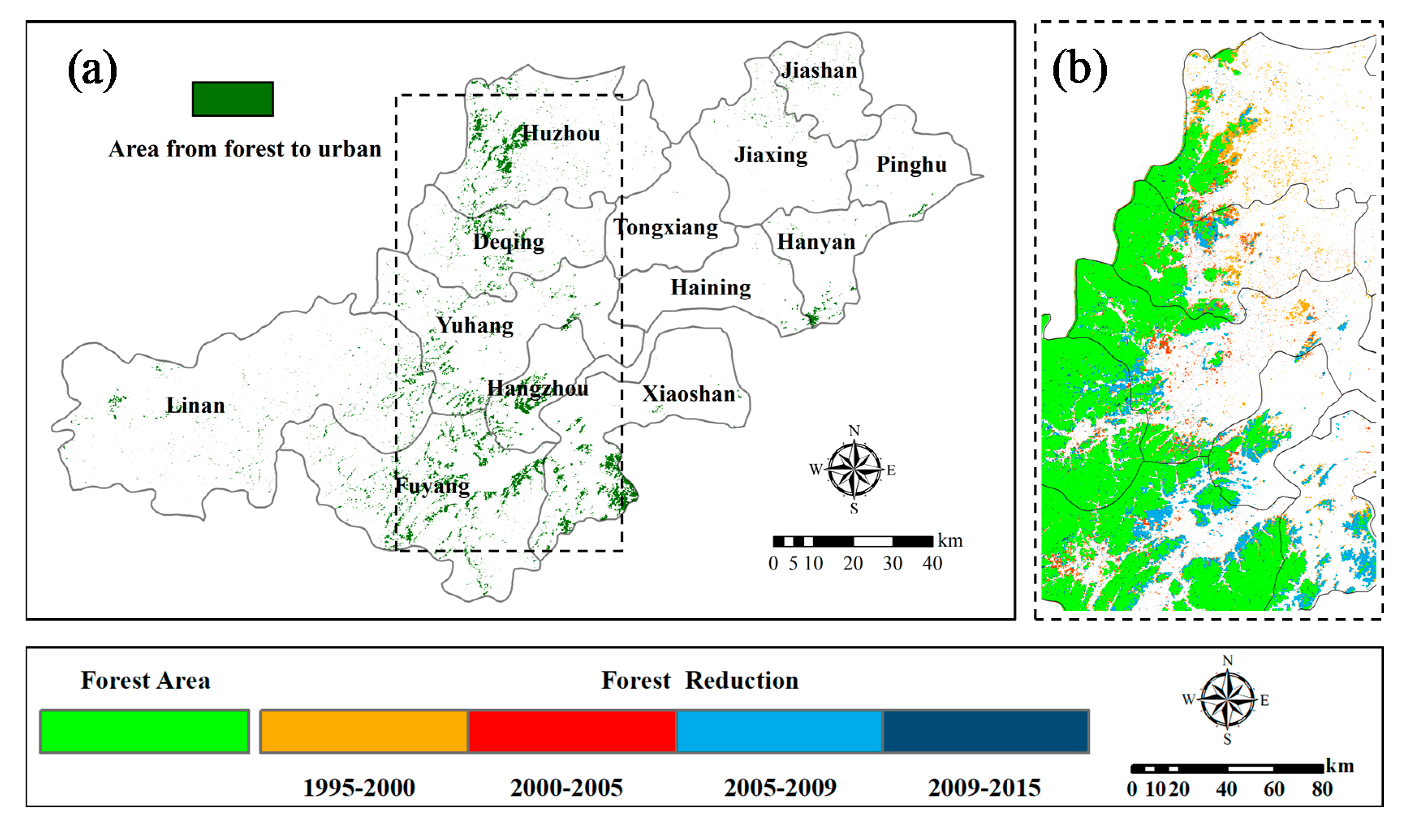
4.4. Impact of Urbanization on Forests
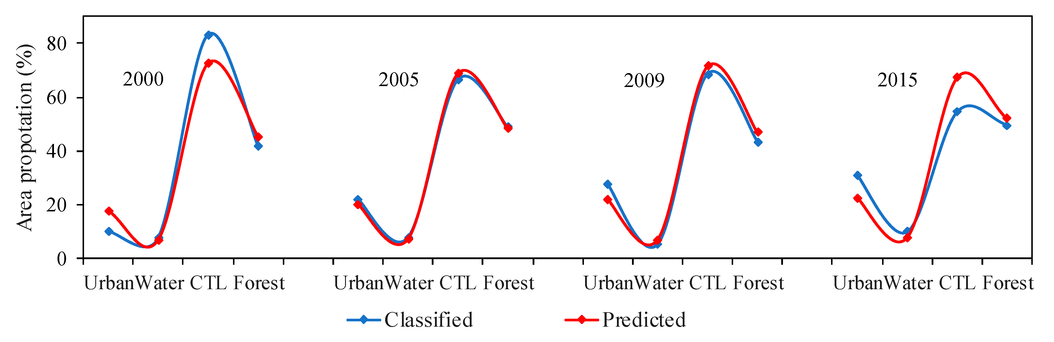
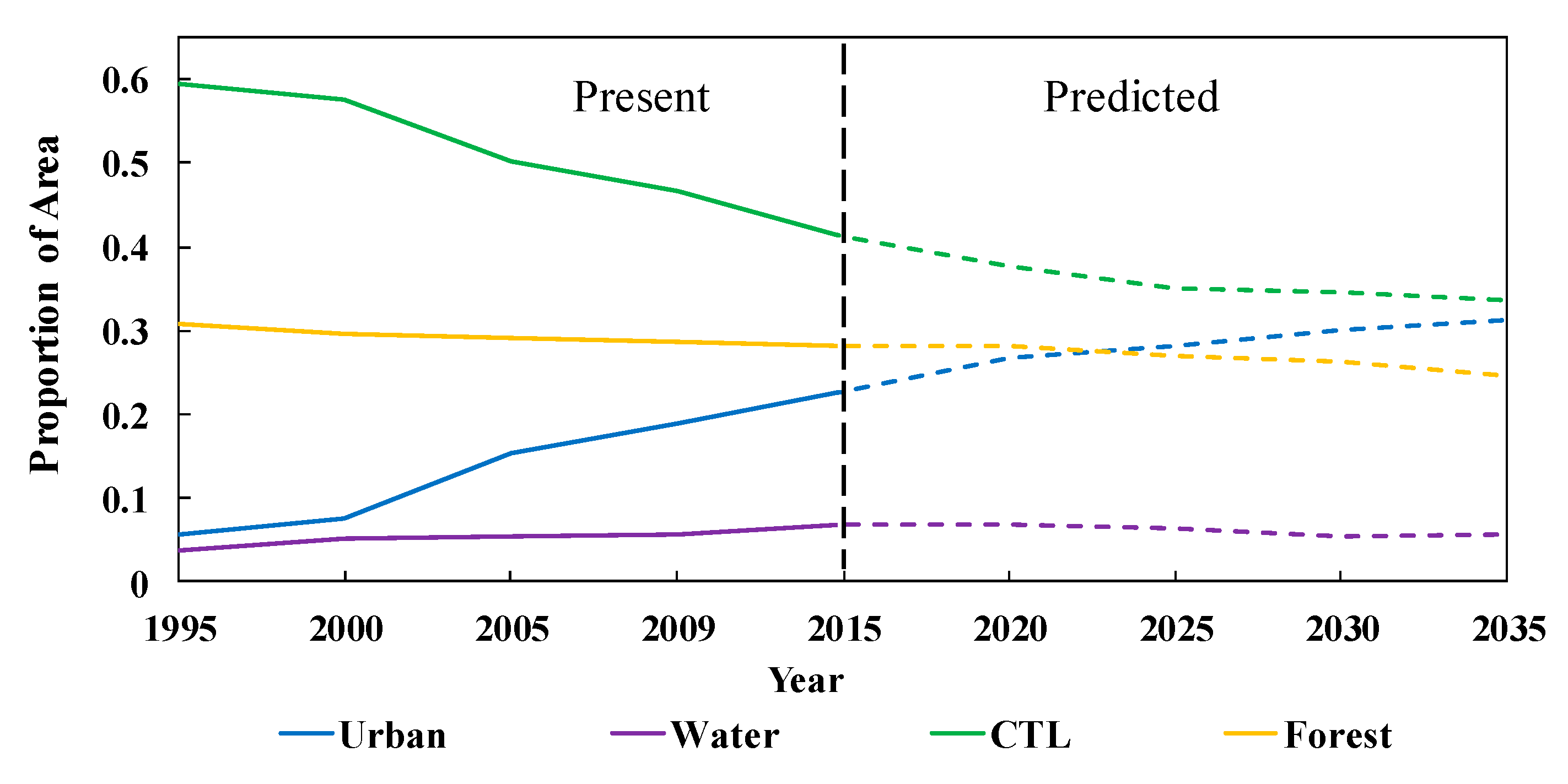
4.5. Prediction of LUCC for the Next 20 Years
5. Discussion
6. Conclusions
Author Contributions
Funding
Acknowledgments
Conflicts of Interest
References
- Wheaton, W.C.; Shishido, H. Urban Concentration, Agglomeration Economies, and the Level of Economic Development. Econ. Dev. Cult. Chang. 1981, 30, 17–30. [Google Scholar] [CrossRef]
- Wu, J.; Chen, B.; Mao, J.; Feng, Z. Spatiotemporal evolution of carbon sequestration vulnerability and its relationship with urbanization in China’s coastal zone. Sci. Total Environ. 2018, 645, 692. [Google Scholar] [CrossRef] [PubMed]
- Zhou, C.; Wang, S.; Wang, J. Examining the influences of urbanization on carbon dioxide emissions in the Yangtze River Delta, China: Kuznets curve relationship. Sci. Total Environ. 2019, 675, 472–482. [Google Scholar] [CrossRef] [PubMed]
- Xu, Q.; Dong, Y.X.; Yang, R. Influence of land urbanization on carbon sequestration of urban vegetation: A temporal cooperativity analysis in Guangzhou as an example. Sci. Total Environ. 2018, 635, 26–34. [Google Scholar] [CrossRef]
- Goodchild, B. Homes, Cities and Neighbourhoods; Routledge: Abingdon, UK, 2008. [Google Scholar]
- Mahmoud, S.H.; Gan, T.Y. Urbanization and climate change implications in flood risk management: Developing an efficient decision support system for flood susceptibility mapping. Sci. Total Environ. 2018, 636, 152–167. [Google Scholar] [CrossRef]
- Güneralp, B.; Zhou, Y.; Ürge-Vorsatz, D.; Gupta, M.; Yu, S.; Patel, P.L.; Fragkias, M.; Li, X.; Seto, K.C. Global scenarios of urban density and its impacts on building energy use through 2050. Proc. Natl. Acad. Sci. USA 2017, 114, 8945. [Google Scholar] [CrossRef]
- Mao, J.X.; Li, Z.G.; Yan, X.P.; Zhou, S.H. The impact of landscape-urbanization upon land use change with microscopic data. Acta Ecol. Sin. 2008, 28, 3584–3596. [Google Scholar]
- Hao, H.M.; Ren, Z.Y. Land Use/Land Cover Change (LUCC) and Eco-Environment Response to LUCC in Farming-Pastoral Zone, China. Agric. Sci. China 2009, 8, 91–97. [Google Scholar] [CrossRef]
- Bing, L.I.; Jun, B.I.; Tian, Y. Analysis of LUCC and Driving Force in Heavy Polluted Area in Taihu Lake Basin. Environ. Sci. Technol. 2011, 5, 43–48. [Google Scholar]
- Schneider, A.; Logan, K.E.; Kucharik, C.J. Impacts of Urbanization on Ecosystem Goods and Services in the U.S. Corn Belt. Ecosystems 2012, 15, 519–541. [Google Scholar] [CrossRef]
- Reynolds, R.; Liang, L.; Li, X.C.; Dennis, J. Monitoring Annual Urban Changes in a Rapidly Growing Portion of Northwest Arkansas with a 20-Year Landsat Record. Remote Sens. 2017, 9, 71. [Google Scholar] [CrossRef]
- Giardina, C.P.; Coleman, M.; Binkley, D.; Hancock, J.; King, J.S.; Lilleskov, E.; Loya, W.M.; Pregitzer, K.S.; Ryan, M.G.; Trettin, C. The Response of Belowground Carbon Allocation in Forests to Global Change. Tree Species Effects on soils: Implications for Global Change; Kluwer Academic Publishers: Dordrecht, The Netherlands, 2005; pp. 119–154, Chapter 7. [Google Scholar]
- Berenguer, E.; Gardner, T.A.; Ferreira, J.; Aragão, L.E.O.C.; Camargo, P.B.; Cerri, C.E.; Durigan, M.; Junior, R.C.O.; Vieira, I.C.G.; Barlow, J. Developing Cost-Effective Field Assessments of Carbon Stocks in Human-Modified Tropical Forests. PLoS ONE 2015, 10, 3713–3726. [Google Scholar] [CrossRef] [PubMed]
- Schneider, A.; Friedl, M.A.; Potere, D. Mapping global urban areas using MODIS 500-m data: New methods and datasets based on ‘urban ecoregions’. Remote Sens. Environ. 2010, 114, 1733–1746. [Google Scholar] [CrossRef]
- Zhou, X.; Chen, H. Impact of urbanization-related land use land cover changes and urban morphology changes on the urban heat island phenomenon. Sci. Total Environ. 2018, 635, 1467–1476. [Google Scholar] [CrossRef] [PubMed]
- Jeon, S.B.; Olofsson, P.; Woodcock, C.E. Land use change in New England: A reversal of the forest transition. J. Land Use Sci. 2014, 9, 105–130. [Google Scholar] [CrossRef]
- Olofsson, P.; Foody, G.M.; Herold, M.; Stehman, S.V.; Woodcock, C.E.; Wulder, M.A. Good practices for estimating area and assessing accuracy of land change. Remote Sens. Environ. 2014, 148, 42–57. [Google Scholar] [CrossRef]
- Zhang, M.; Du, H.; Zhou, G.; Li, X.; Mao, F.; Dong, L.; Zheng, J.; Liu, H.; Huang, Z.; He, S. Estimating Forest Aboveground Carbon Storage in Hang-Jia-Hu Using Landsat TM/OLI Data and Random Forest Model. Forests 2019, 10, 1004. [Google Scholar] [CrossRef]
- Giraldo, M.A. Land-use and land-cover assessment for the study of lifestyle change in a rural Mexican community: The Maycoba Project. Int. J. Health Geogr. 2012, 11, 27. [Google Scholar] [CrossRef]
- Arifasihati, Y. Analysis of Land Use and Cover Changes in Ciliwung and Cisadane Watershed in three Decades. Procedia Environ. Sci. 2016, 33, 465–469. [Google Scholar] [CrossRef][Green Version]
- Wang, Y.; Liu, L.; Wang, Z. Land Covermapping based on Landsat Time-series Stacks in Sanjiang Plain. Remote Sens. Technol. Appl. 2015, 30, 959–968. [Google Scholar]
- Du, H.; Sun, X.; Han, N.; Mao, F. Comprehensive object-oriented and decision-making tree survey factors and remote sensing estimation of carbon stocks. J. Appl. Ecol. 2017, 28, 3163–3173. [Google Scholar]
- Bounoua, L.; Ping, Z.; Mostovoy, G.; Thome, K.; Masek, J.; Imhoff, M.; Shepherd, M.; Quattrochi, D.; Santanello, J.; Silva, J. Impact of urbanization on US surface climate. Environ. Res. Lett. 2015, 10, 084010. [Google Scholar] [CrossRef]
- Ding, J. Study on oasis water body themation extraction using PCA way. Yunnan Geogr. Environ. Res. 2005, 17, 11–14. [Google Scholar]
- Lu, M.; Xu, Y.; Shan, N.; Wang, Q.; Wang, J. Effect of urbanisation on extreme precipitation based on nonstationary models in the Yangtze River Delta metropolitan region. Sci. Total Environ. 2019, 673, 64–73. [Google Scholar] [CrossRef] [PubMed]
- Luan, C.; Dong, G. Experimental Identification of Hard Data Sets for Classification and Feature Selection Methods with Insights on Method Selection. Data Knowl. Eng. 2018, 118, 41–51. [Google Scholar] [CrossRef]
- Foster, K.R.; Koprowski, R.; Skufca, J.D. Machine learning, medical diagnosis, and biomedical engineering research-commentary. Biomed. Eng. Online 2014, 13, 94. [Google Scholar] [CrossRef]
- Kotsiantis, S.B. Supervised machine learning: A review of classification techniques. Emerg. Artif. Intell. Appl. Comput. Eng. 2007, 160, 3–24. [Google Scholar]
- Schleier-Smith, J. An Architecture for Agile Machine Learning in Real-Time Applications. In Proceedings of the 21th ACM SIGKDD International Conference on Knowledge Discovery and Data Mining (KDD’15), Sydney, Australia, 10–13 August 2015; pp. 2059–2068. [Google Scholar]
- Zaman, S.; Rifat, S.M.R. Performance Analysis of Supervised Machine Learning Algorithms for Text Classification. In Proceedings of the 19th International Conference on Computer and Information Technology (ICCIT), Dhaka, Bangladesh, 18–20 December 2016. [Google Scholar]
- Kinnings, S.L.; Liu, N.; Tonge, P.J.; Jackson, R.M.; Xie, L.; Bourne, P.E. Correction to “A Machine Learning-Based Method To Improve Docking Scoring Functions and Its Application to Drug Repurposing”. J. Chem. Inf. Model. 2011, 51, 408–419. [Google Scholar] [CrossRef]
- Zhou, Z.H.; Feng, J. Deep Forest: Towards an Alternative to Deep Neural Networks. arXiv 2017, arXiv:1702.08835. [Google Scholar]
- Shankru, G.; Vijayakumar, K.; Umadevi, V. Non-Sequential Partitioning Approaches to Decision Tree classifier. Future Comput. Inform. J. 2018, 3, 275–285. [Google Scholar]
- Lan, T.; Zhang, Y.; Jiang, C.; Yang, G.; Zhao, Z. Automatic identification of Spread F using decision trees. J. Atmos. Sol.-Terr. Phys. 2018, 179, 389–395. [Google Scholar] [CrossRef]
- Hansen, M.C.; Defries, R.S.; Townshend, J.R.G.; Sohlberg, R. Global land cover classification at 1 km spatial resolution using a classification tree approach. Int. J. Remote Sens. 2000, 21, 1331–1364. [Google Scholar] [CrossRef]
- Wang, C.; Wang, J. Cloud-service decision tree classification for education platform. Cogn. Syst. Res. 2018, 52, 234–239. [Google Scholar]
- Xiaohu, W.; Lele, W.; Nianfeng, L. An Application of Decision Tree Based on ID3. Phys. Procedia 2012, 25, 1017–1021. [Google Scholar] [CrossRef]
- Cui, L.; Du, H.; Zhou, G.; Li, X.; Mao, F.; Xu, X.; Li, P.; Zhu, D.; Liu, T.; Xing, L. Combination of decision tree and linear spectral unmixing for extracting bamboo forest information in China. J. Remote Sens. 2018, 22, 609–619. [Google Scholar]
- Funkenberg, T.; Binh, T.T.; Moder, F.; Dech, S. The Ha Tien Plain—Wetland monitoring using remote-sensing techniques. Int. J. Remote Sens. 2014, 35, 2893–2909. [Google Scholar] [CrossRef][Green Version]
- Lv, Y.; Zhang, C.; Xun, W.; Li, P.; Sang, L.; Chen, Y. Automatic Recognition of Farmland Shelterbelts in High Spatial Resolution Remote Sensing Data. J. Agric. Mach. 2018, 49, 157–163. [Google Scholar]
- Ai, L.Y.; Yi, T.Q.; Li, D.W. Current Status of Hangjiahu Plain Wetlands Resources and Proposals for Protection and Management. Adv. Mater. Res. 2014, 955, 3683–3686. [Google Scholar]
- Zhu, H.C.; Shen, J.G.; Wang, Z.D.; Lin, Y.; Zhang, Z.J. Phosphorus status on overlying water-sediment of typical riparian wetlands in Hangjiahu plain region and its impact to water quality. J. Zhejiang Univ. 2009, 35, 450–459. [Google Scholar] [CrossRef]
- Yu, H.; Joshi, P.K.; Das, K.K.; Chauniyal, D.D.; Melick, D.R.; Yang, X.; Xu, J. Land use/cover change and environmental vulnerability analysis in Birahi Ganga sub-watershed of the Garhwal Himalaya, India. Trop. Ecol. 2007, 48, 241–250. [Google Scholar]
- Sharma, K.; Robeson, S.M.; Thapa, P.; Saikia, A. Land-use/land-cover change and forest fragmentation in the Jigme Dorji National Park, Bhutan. Phys. Geogr. 2016, 38, 18–35. [Google Scholar] [CrossRef]
- Cooley, T.; Anderson, G.P.; Felde, G.W.; Hoke, M.L.; Ratkowski, A.J.; Chetwynd, J.H.; Gardner, J.A.; Adler-Golden, S.M.; Matthew, M.W.; Berk, A. FLAASH, a MODTRAN4-based atmospheric correction algorithm, its application and validation. In Proceedings of the Geoscience and Remote Sensing Symposium (IGARSS ’02), Toronto, ON, Canada, 24–28 June 2002; Volume 1413, pp. 1414–1418. [Google Scholar]
- Perkins, T.; Adler-Golden, S.; Matthew, M.W.; Berk, A.; Bernstein, L.S.; Lee, J.; Fox, M. Speed and accuracy improvements in FLAASH atmospheric correction of hyperspectral imagery. Opt. Eng. 2012, 51, 1707. [Google Scholar] [CrossRef]
- Li, Y.; Han, N.; Li, X.; Du, H.; Mao, F.; Cui, L.; Liu, T.; Xing, L. Spatiotemporal Estimation of Bamboo Forest Aboveground Carbon Storage Based on Landsat Data in Zhejiang, China. Remote Sens. 2018, 10, 898. [Google Scholar] [CrossRef]
- Sun, X.; Du, H.; Han, N.; Ge, H.; Gu, C. Multi-Scale Segmentation, Object-Based Extraction of Moso Bamboo Forest from SPOT5 Imagery. Sci. Silvae Sin. 2013, 49, 80–87. [Google Scholar]
- Li, X.; Du, H.; Mao, F.; Zhou, G.; Liang, C.; Xing, L.; Fan, W.; Xu, X.; Liu, Y.; Lu, C. Estimating bamboo forest aboveground biomass using EnKF-assimilated MODIS LAI spatiotemporal data and machine learning algorithms. Agric. For. Meteorol. 2018, 256, 445–457. [Google Scholar] [CrossRef]
- Huang, J.; Ling, C.X. Using AUC and accuracy in evaluating learning algorithms. IEEE Trans. Knowl. Data Eng. 2005, 17, 299–310. [Google Scholar] [CrossRef]
- Duro, D.C.; Franklin, S.E.; Dubé, M.G. A comparison of pixel-based and object-based image analysis with selected machine learning algorithms for the classification of agricultural landscapes using SPOT-5 HRG imagery. Remote Sens. Environ. 2012, 118, 259–272. [Google Scholar] [CrossRef]
- Pal, M.; Mather, P.M. An assessment of the effectiveness of decision tree methods for land cover classification. Remote Sens. Environ. 2003, 86, 554–565. [Google Scholar] [CrossRef]
- Han, N.; Du, H.; Zhou, G.; Xu, X.; Ge, H.; Liu, L.; Gao, G.; Sun, S. Exploring the synergistic use of multi-scale image object metrics for land-use/land-cover mapping using an object-based approach. Int. J. Remote Sens. 2015, 36, 3544–3562. [Google Scholar] [CrossRef]
- Rajeswari, S.; Suthendran, K. C5.0: Advanced Decision Tree (ADT) classification model for agricultural data analysis on cloud. Comput. Electron. Agric. 2019, 156, 530–539. [Google Scholar] [CrossRef]
- Uğuz, H. A two-stage feature selection method for text categorization by using information gain, principal component analysis and genetic algorithm. Knowl.-Based Syst. 2011, 24, 1024–1032. [Google Scholar] [CrossRef]
- Praveena, P.R.; Valarmathi, M.L.; Sivakumari, S. Gain ratio based feature selection method for privacy preservation. ICTACT J. Soft Comput. 2011, 1, 201–205. [Google Scholar]
- Ran, C.L.; Wang, X.J. Building a Decision Tree Model for Campus Information Score Based on the Algorithm C5.0. Appl. Mech. Mater. 2015, 719, 805–811. [Google Scholar] [CrossRef]
- Pang, S.L.; Gong, J.Z. C5.0 Classification Algorithm and Application on Individual Credit Evaluation of Banks. Syst. Eng.-Theory Pract. 2009, 29, 94–104. [Google Scholar] [CrossRef]
- Siknun, G.P.; Sitanggang, I.S. Web-based Classification Application for Forest Fire Data Using the Shiny Framework and the C5.0 Algorithm. Procedia Environ. Sci. 2016, 33, 332–339. [Google Scholar] [CrossRef]
- Quinlan, R. Data mining tools see5 and c5. Res. Net 2008. Available online: https://www.researchgate.net/publication/242373794_Data_mining_tools_see5_and_c5/citation/download. (accessed on 10 January 2020).
- Xu, M.; Jia, X.; Pickering, M.; Jia, S. Thin cloud removal from optical remote sensing images using the noise-adjusted principal components transform. ISPRS J. Photogramm. Remote Sens. 2019, 149, 215–225. [Google Scholar] [CrossRef]
- Ren, H.; Zhou, G.; Feng, Z. Using negative soil adjustment factor in soil-adjusted vegetation index (SAVI) for aboveground living biomass estimation in arid grasslands. Remote Sens. Environ. 2018, 209, 439–445. [Google Scholar] [CrossRef]
- Qi, J.; Chehbouni, A.; Huete, A.R.; Kerr, Y.H.; Sorooshian, S.S. A modified soil adjusted vegetation index. Remote Sens. Envrion. 2015, 48, 119–126. [Google Scholar] [CrossRef]
- Cui, R.R.; Du, H.Q.; Zhou, G.M.; Xu, X.J.; Dong, D.J.; Lv, Y.L. Dynamic remote sensing monitoring and carbon storage changes of bamboo forest in Anji County in the past 30 years. J. Zhejiang Agric. For. Univ. 2011, 28, 422–431. [Google Scholar]
- Zhu, H.; Li, X. Discussion on the Model Method of Regional Land Use Change Index. Acta Geogr. Sin. 2003, 58, 643–650. [Google Scholar]
- Wang, X.; Bao, Y. Study on the methods of land use dynamic change research. Prog. Geogr. 1999, 18, 81–87. [Google Scholar]
- Li, Y.; Du, H.; Mao, F.; Li, X.; Cui, L.; Han, N.; Xu, X. Information extracting and spatiotemporal evolution of bamboo forest based on Landsat time series data in Zhejiang Province. Sci. Silvae Sin. 2019, 55, 88–96. [Google Scholar]
- Mondal, M.S.; Sharma, N.; Garg, P.K.; Kappas, M. Statistical independence test and validation of CA Markov land use land cover (LULC) prediction results. Egypt. J. Remote Sens. Space Sci. 2016, 19, 259–272. [Google Scholar] [CrossRef]
- Du, H.; Zhou, G.; Xu, X. Quantitative Methods Using Remote Sensing in Estimating Biomass and Carbon Storage of Bamboo Forest; Science Press: Beijing, China, 2012. [Google Scholar]
- Jiang, X.; Lu, D.; Moran, E.; Calvi, M.F.; Dutra, L.V.; Li, G. Examining impacts of the Belo Monte hydroelectric dam construction on land-cover changes using multitemporal Landsat imagery. Appl. Geogr. 2018, 97, 35–47. [Google Scholar] [CrossRef]


| WRS2 Row/Path. | 1995 | 2000 | 2005 | 2009 | 2015 |
|---|---|---|---|---|---|
| Landsat5 TM | Landsat5 TM | Landsat5 TM | Landsat5 TM | Landsat8 OLI | |
| 118039 | 12/08/1995 | 06/06/2000 | 27/11/2005 | 17/07/2009 | 03/08/2015 |
| 119039 | 09/12/1995 | 17/09/2000 | 17/10/2005 | 13/01/2009 | 13/10/2015 |
| 120039 | 06/05/1995 | 10/10/2000 | 24/10/2005 | 06/12/2009 | 06/02/2015 |
| Year | Urban | Water | CTL | BLF | CNF | BMF | Total |
|---|---|---|---|---|---|---|---|
| 1995 | 46 | 37 | 51 | 45 | 48 | 45 | 272 |
| 2000 | 47 | 35 | 43 | 41 | 40 | 48 | 254 |
| 2005 | 47 | 39 | 46 | 47 | 44 | 48 | 271 |
| 2009 | 48 | 36 | 40 | 46 | 42 | 56 | 268 |
| 2015 | 42 | 40 | 49 | 45 | 47 | 46 | 269 |
| Type | Name | Calculation Models or Descriptions | Abbreviation | Remarks |
|---|---|---|---|---|
| Original Band | Band1 | band1 (band2 *) | B1 | Suitable Landsat5 TM (1995, 2000, 2005,2009) and Landsat8 OLI (2015) data with * |
| Band2 | band2 (band3 *) | B2 | ||
| Band3 | band3 (band4 *) | B3 | ||
| Band4 | band4 (band5 *) | B4 | ||
| Band5 | band5 (band6 *) | B5 | ||
| Band6 | band6 (band7 *) | B6 | ||
| Vegetation Index | NDVI | (B4 − B3)/(B4+B3) | B7 | L take value for 0.5 [63,64] |
| EVI | 2.5 × (B4 − B3)/(B4 + 6 × B3 − 7.5 × B1 + 1) | B8 | ||
| SAVI | (B4 − B3) (1 + L)/(B4 + B3 + L) | B9 | ||
| MNDWI | (B3 − B5)/(B3 + B5) | B10 | ||
| Component Eigenvalue | PC_1 | First principal component | B11 | Principal component analysis in ENVI software |
| PC_2 | Second principal component | B12 | ||
| PC_3 | Third principal component | B13 |
| Year | Average of PA and UA (%) | Overall Accuracy (%) | Kappa Coefficient | |||||
|---|---|---|---|---|---|---|---|---|
| Urban | Water | CTL | BLF | CNF | BMF | |||
| 1995 | 92.39 | 98.22 | 90.69 | 94.65 | 89.50 | 81.18 | 90.59 | 0.87 |
| 2000 | 100.00 | 92.86 | 87.50 | 90.10 | 92.72 | 86.31 | 93.30 | 0.90 |
| 2005 | 92.11 | 91.60 | 96.16 | 94.37 | 91.38 | 89.28 | 96.92 | 0.96 |
| 2009 | 92.10 | 91.67 | 85.21 | 94.16 | 95.45 | 91.84 | 90.04 | 0.88 |
| 2015 | 95.84 | 100.00 | 97.50 | 90.23 | 94.77 | 87.06 | 95.94 | 0.95 |
| Average | 94.49 | 94.87 | 91.41 | 92.70 | 91.48 | 88.42 | 93.40 | 0.91 |
| Land Type | Unclassified | Urban | Water | CTL | BLF | CNF | BMF |
|---|---|---|---|---|---|---|---|
| Unclassified | 0.961 | 0.015 | 0.002 | 0.007 | 0.005 | 0.007 | 0.003 |
| Urban | 0.008 | 0.705 | 0.002 | 0.244 | 0.012 | 0.018 | 0.011 |
| Water | 0.003 | 0.093 | 0.761 | 0.127 | 0.007 | 0.006 | 0.003 |
| CTL | 0.014 | 0.035 | 0.045 | 0.814 | 0.021 | 0.045 | 0.026 |
| BLF | 0.006 | 0.009 | 0.005 | 0.009 | 0.756 | 0.114 | 0.101 |
| CNF | 0.003 | 0.008 | 0.009 | 0.005 | 0.104 | 0.830 | 0.041 |
| BMF | 0.005 | 0.006 | 0.003 | 0.007 | 0.112 | 0.116 | 0.751 |
© 2020 by the authors. Licensee MDPI, Basel, Switzerland. This article is an open access article distributed under the terms and conditions of the Creative Commons Attribution (CC BY) license (http://creativecommons.org/licenses/by/4.0/).
Share and Cite
Zhang, M.; Du, H.; Mao, F.; Zhou, G.; Li, X.; Dong, L.; Zheng, J.; Zhu, D.; Liu, H.; Huang, Z.; et al. Spatiotemporal Evolution of Urban Expansion Using Landsat Time Series Data and Assessment of Its Influences on Forests. ISPRS Int. J. Geo-Inf. 2020, 9, 64. https://doi.org/10.3390/ijgi9020064
Zhang M, Du H, Mao F, Zhou G, Li X, Dong L, Zheng J, Zhu D, Liu H, Huang Z, et al. Spatiotemporal Evolution of Urban Expansion Using Landsat Time Series Data and Assessment of Its Influences on Forests. ISPRS International Journal of Geo-Information. 2020; 9(2):64. https://doi.org/10.3390/ijgi9020064
Chicago/Turabian StyleZhang, Meng, Huaqiang Du, Fangjie Mao, Guomo Zhou, Xuejian Li, Luofan Dong, Junlong Zheng, Di’en Zhu, Hua Liu, Zihao Huang, and et al. 2020. "Spatiotemporal Evolution of Urban Expansion Using Landsat Time Series Data and Assessment of Its Influences on Forests" ISPRS International Journal of Geo-Information 9, no. 2: 64. https://doi.org/10.3390/ijgi9020064
APA StyleZhang, M., Du, H., Mao, F., Zhou, G., Li, X., Dong, L., Zheng, J., Zhu, D., Liu, H., Huang, Z., & He, S. (2020). Spatiotemporal Evolution of Urban Expansion Using Landsat Time Series Data and Assessment of Its Influences on Forests. ISPRS International Journal of Geo-Information, 9(2), 64. https://doi.org/10.3390/ijgi9020064