
Initial Results of the Precise Orbit Determination for the New-Generation BeiDou Satellites (BeiDou-3) Based on the iGMAS Network


Abstract
:1. Introduction
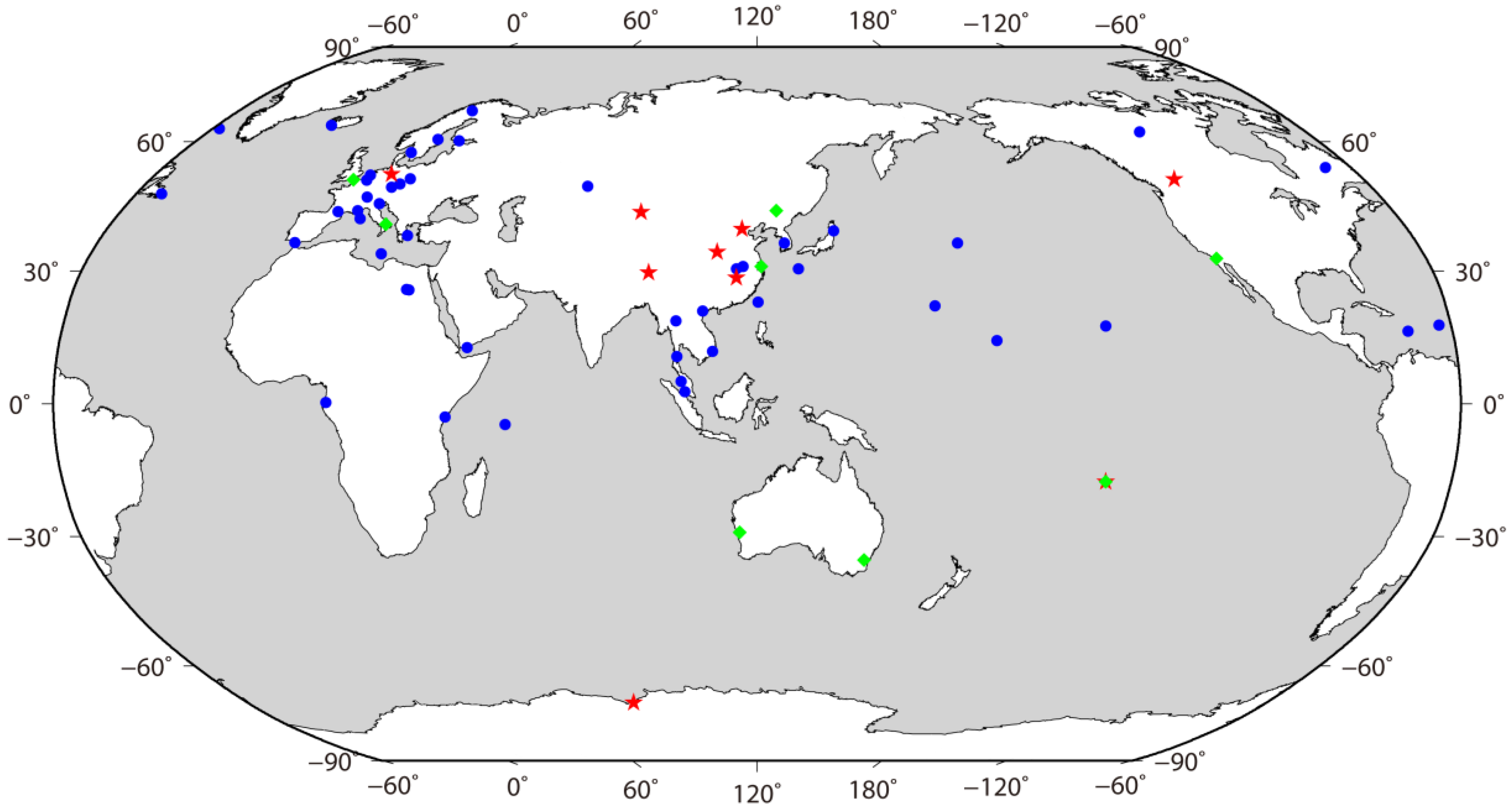
2. Data Collection for BeiDou-3 Satellites POD
3. Methods and Strategies for BeiDou-3 and BeiDou-2 Satellite POD
4. Results
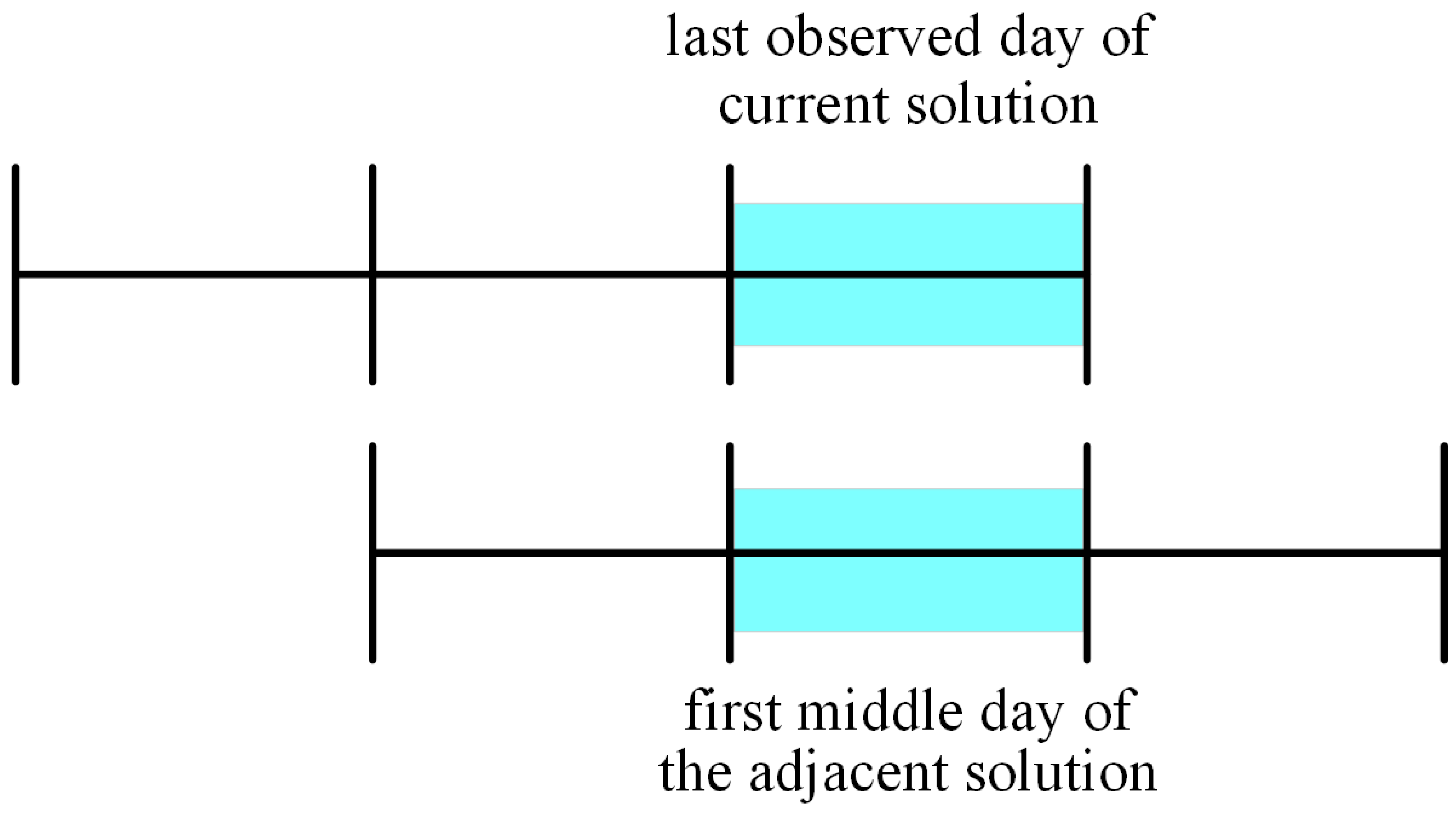
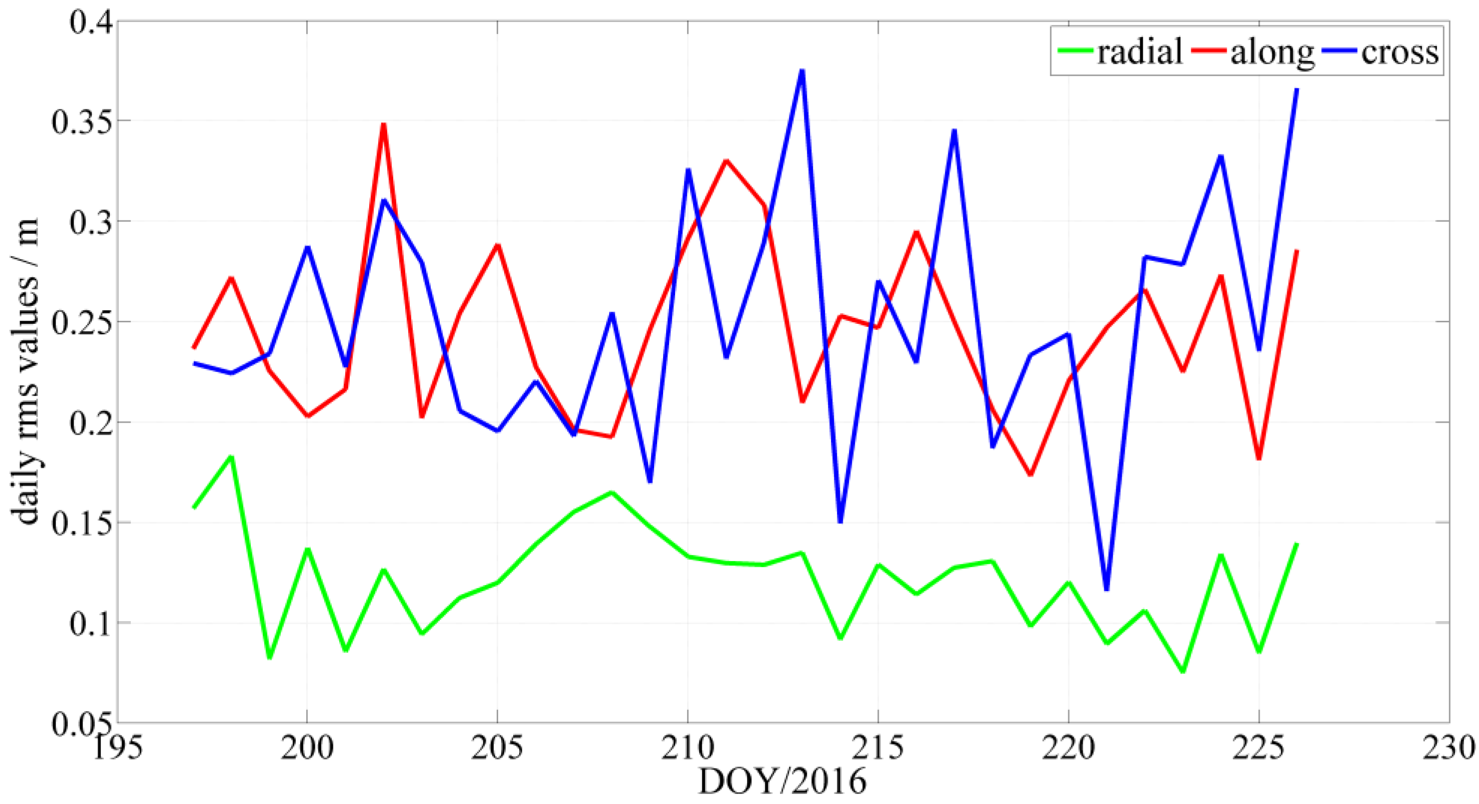
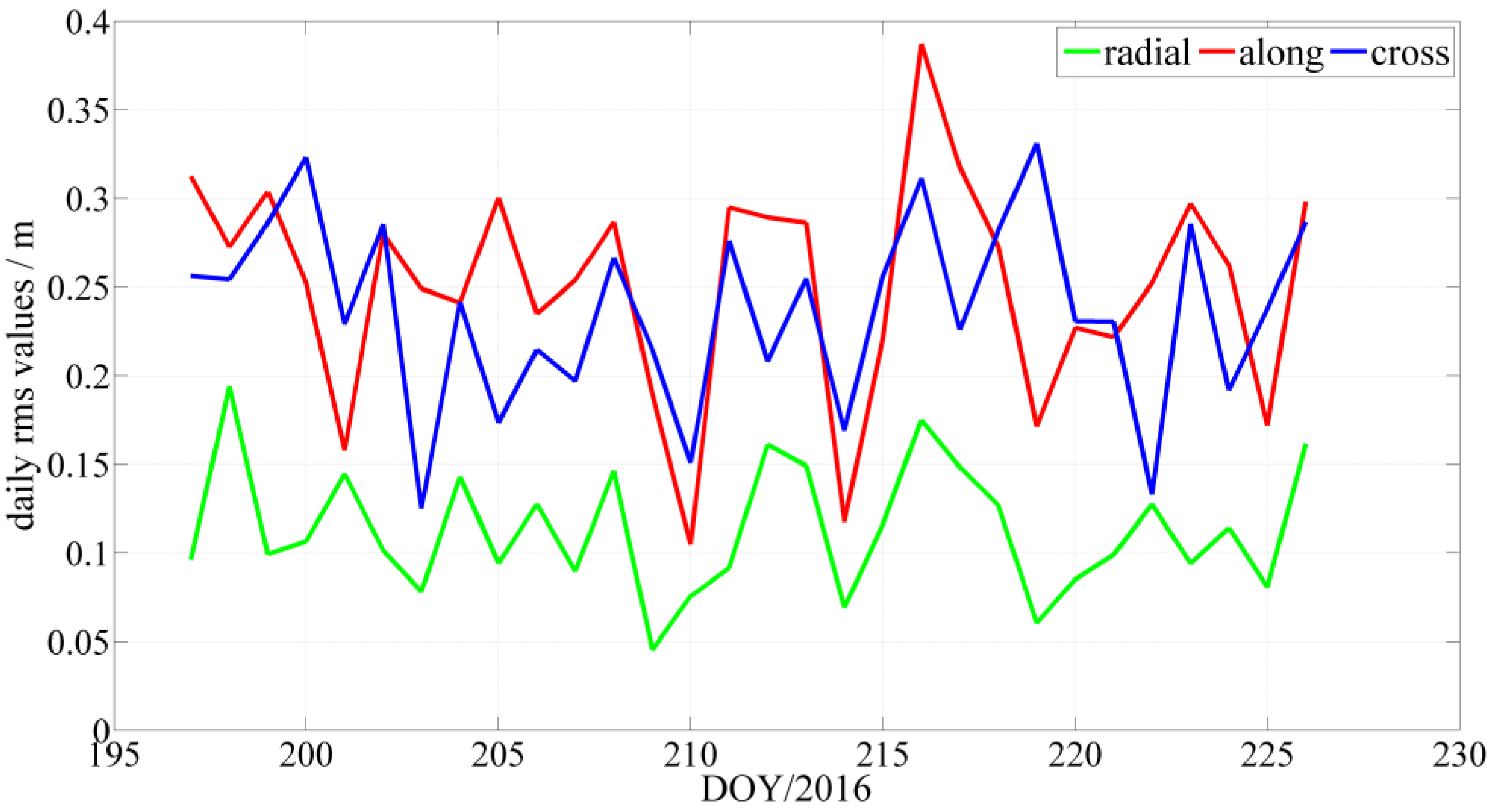
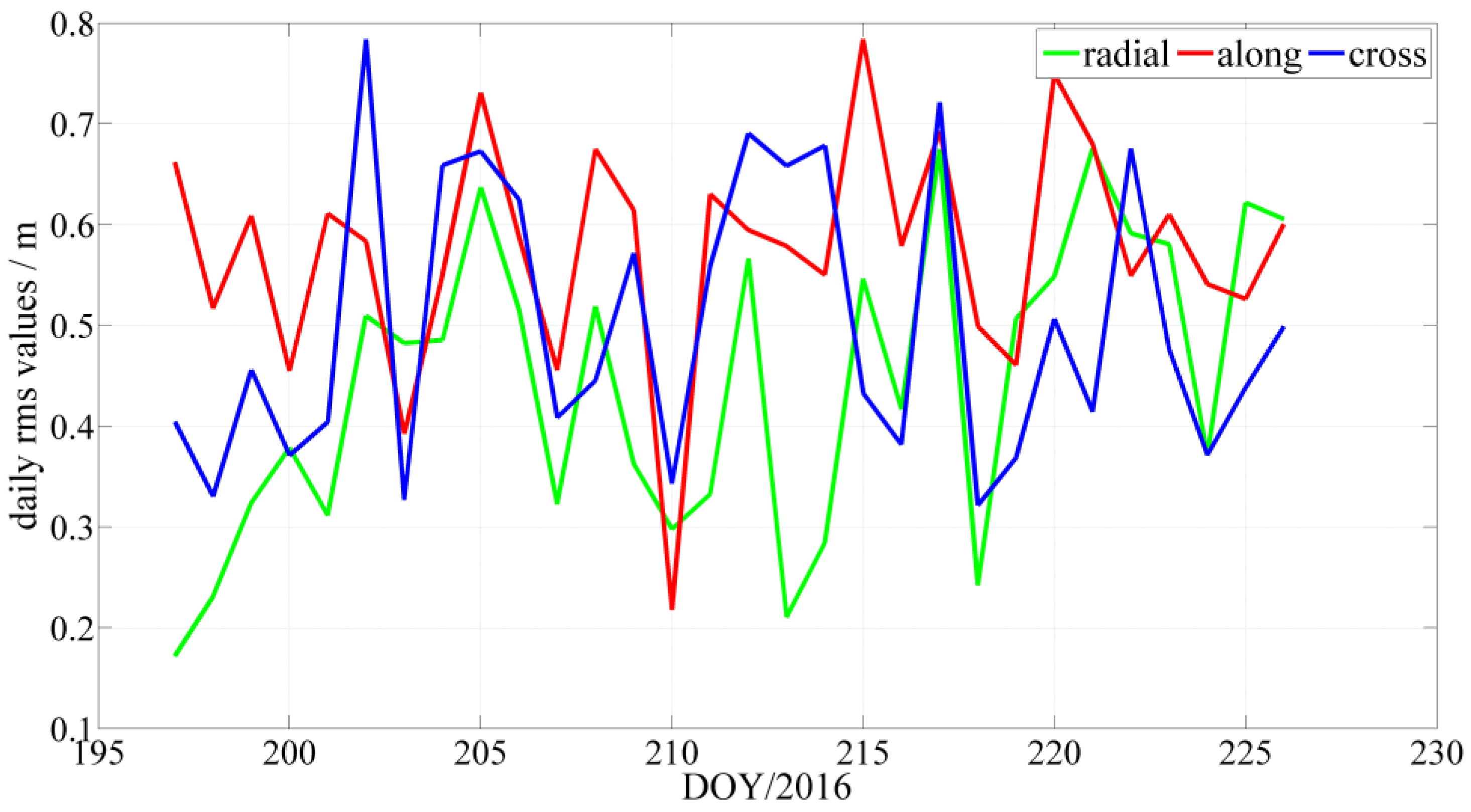
4.1. Overlap Comparison
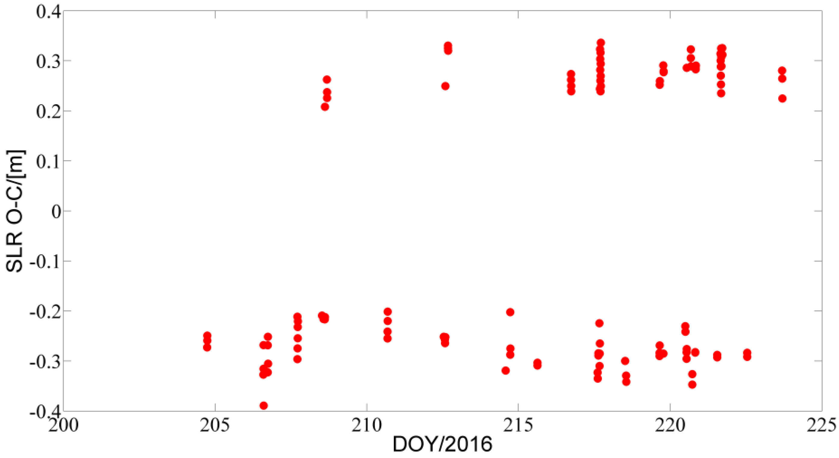
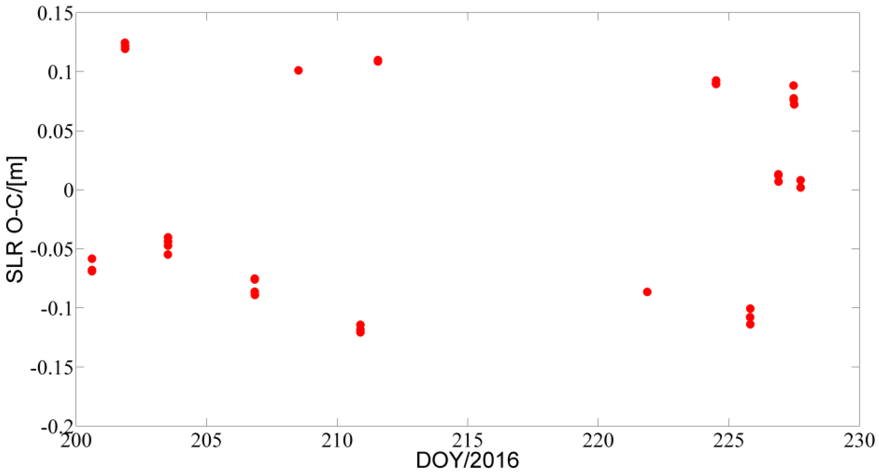
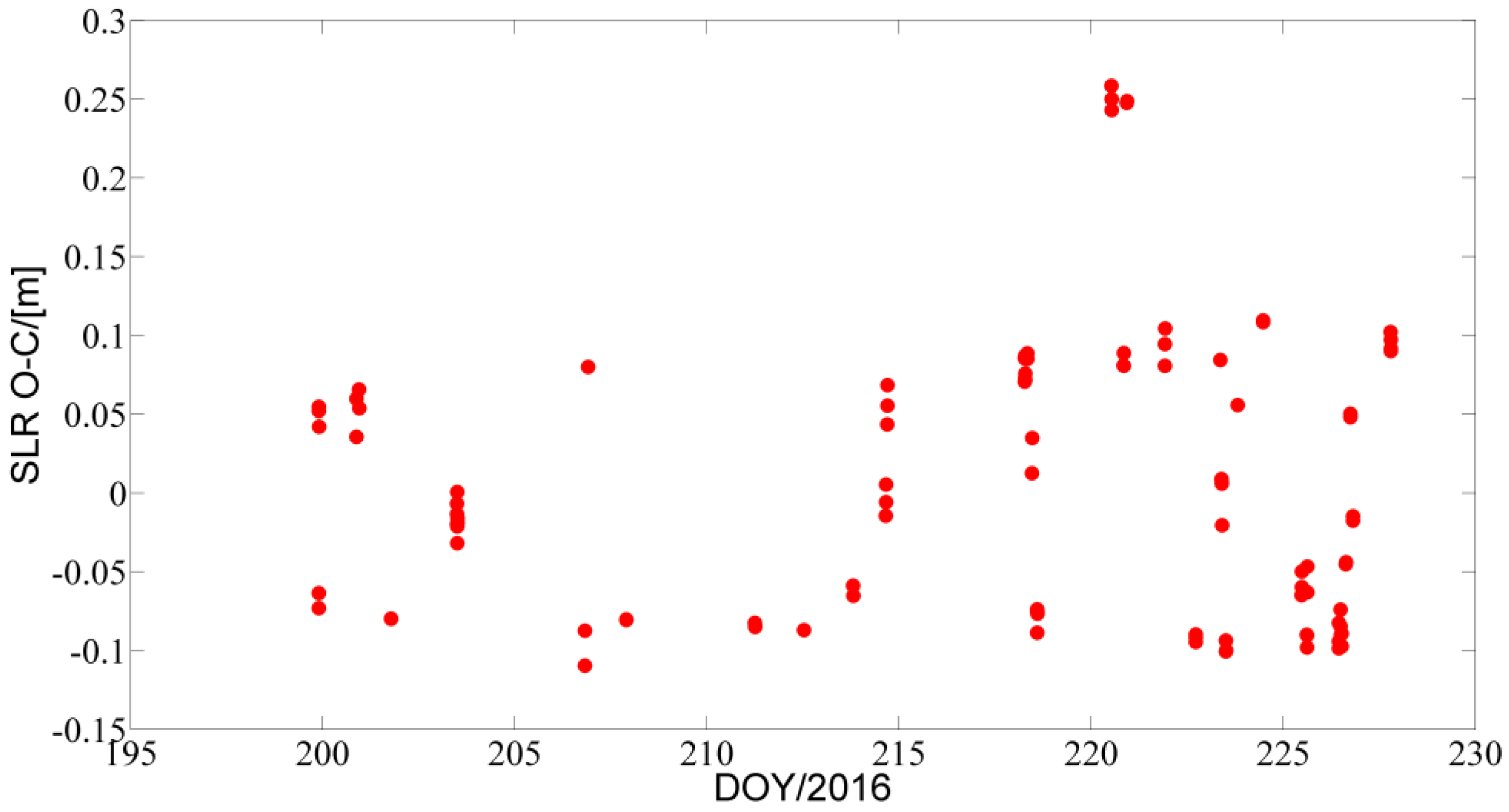
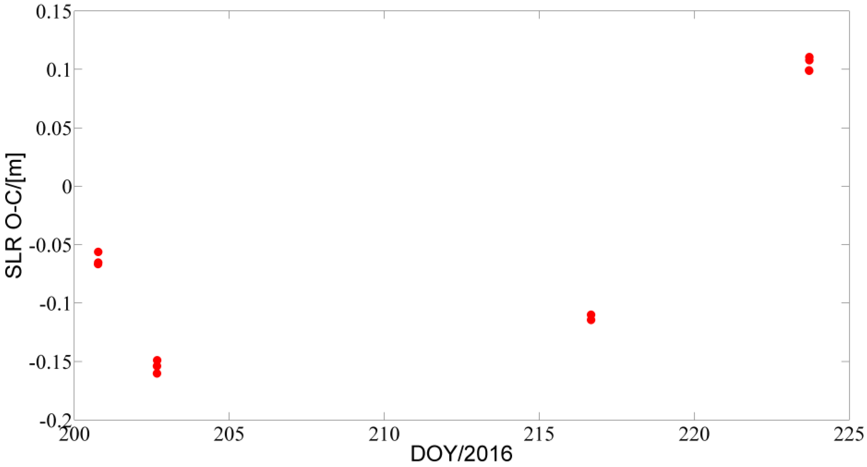
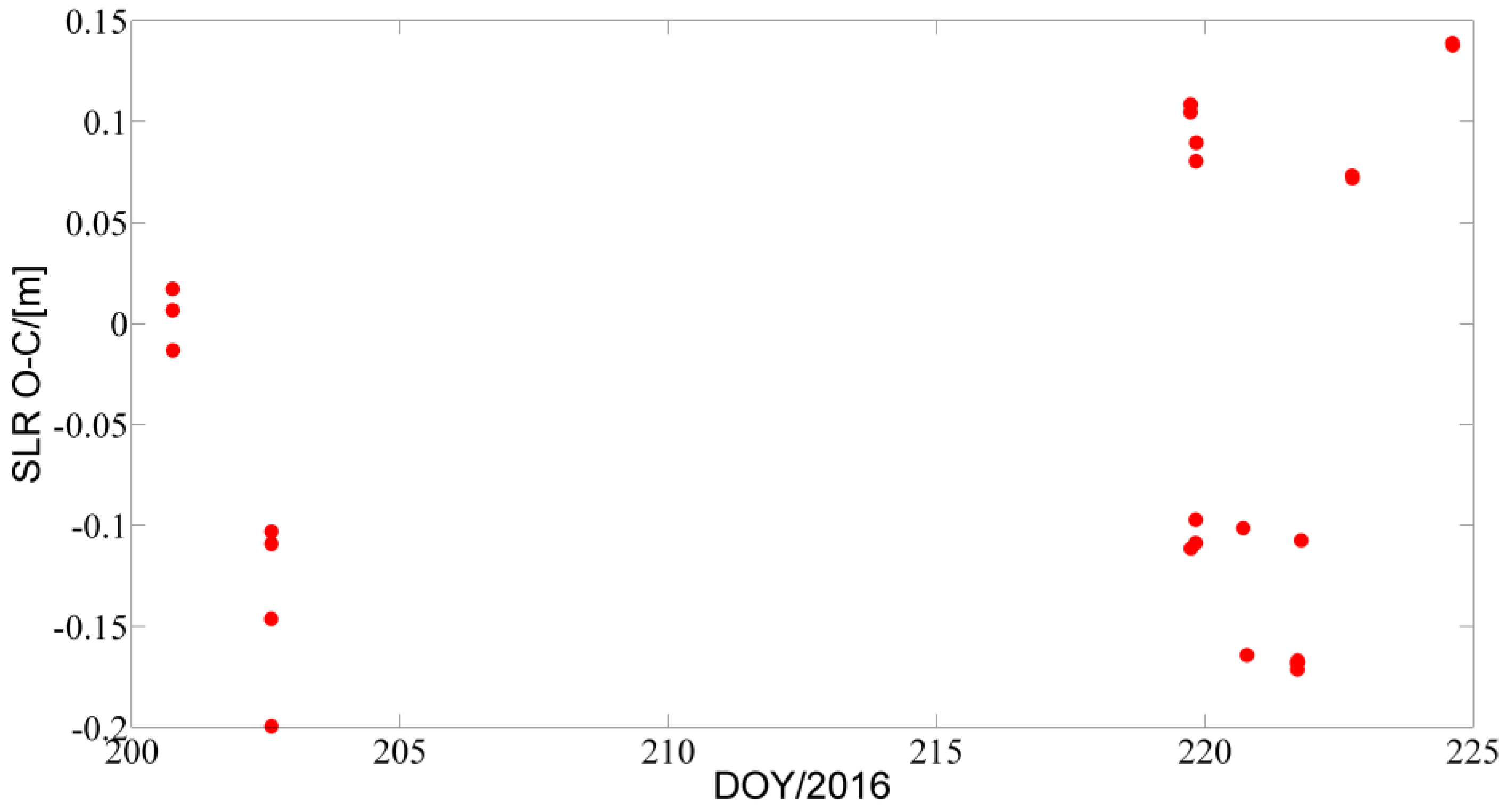
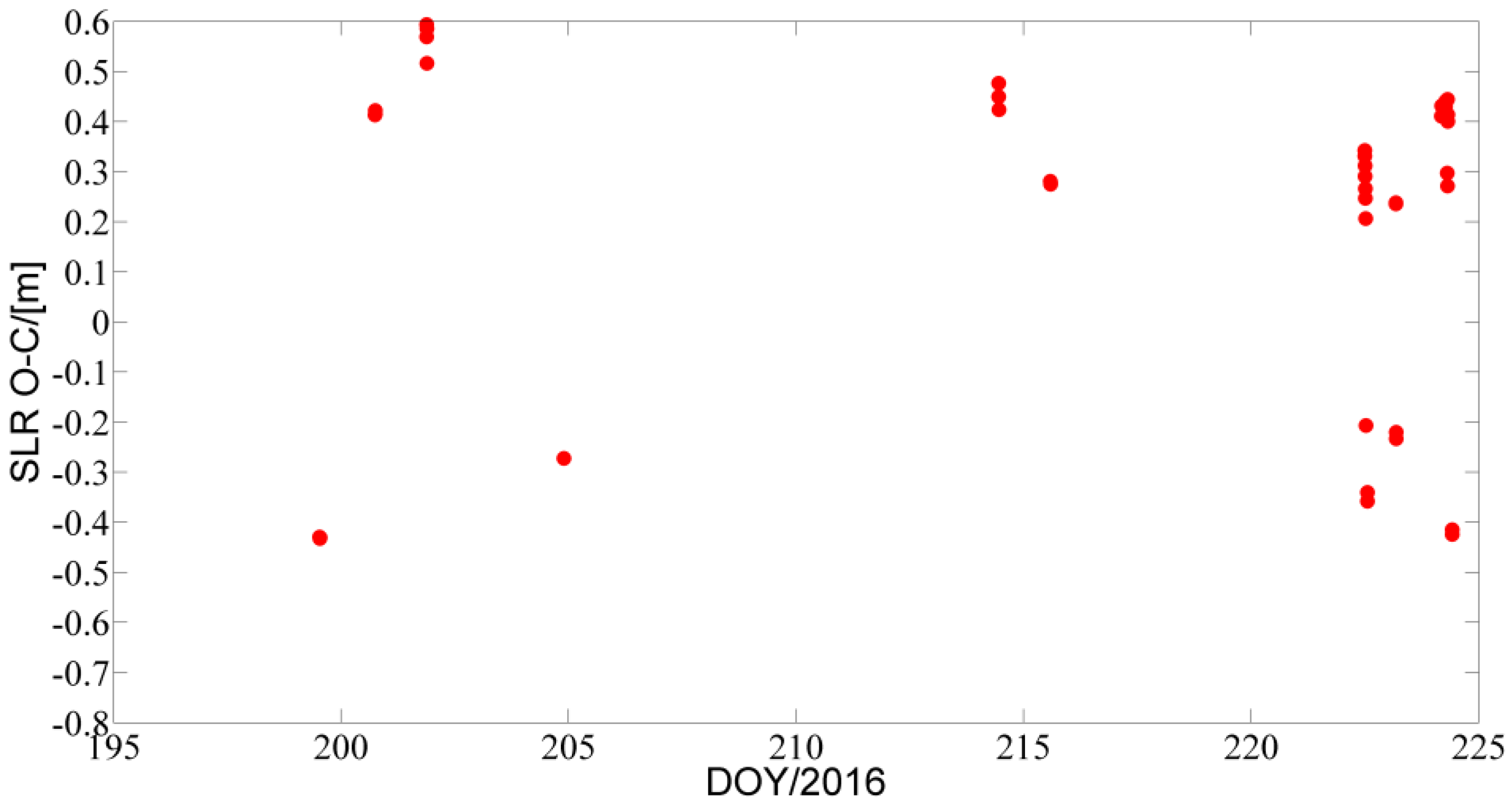
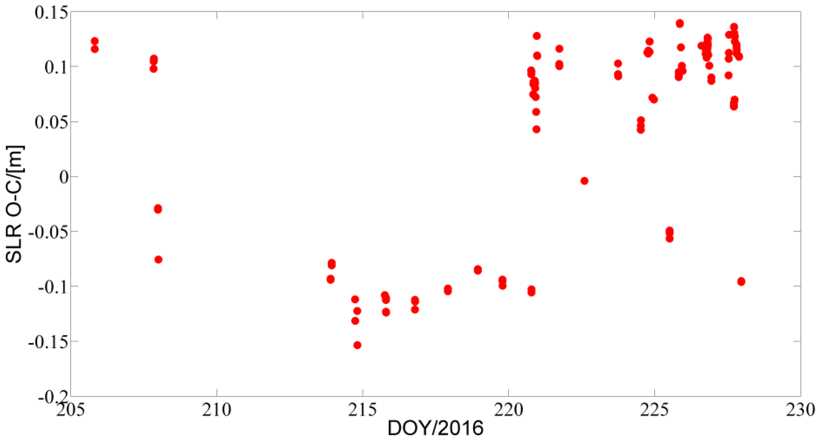
4.2. SLR Validation
5. Conclusions and Discussion
Acknowledgments
Author Contributions
Conflicts of Interest
References
- Yang, Y. Progress, contribution and challenges of compass/BeiDou satellite navigation system. Acta Geod. Cartogr. Sin. 2010, 39, 1–6. [Google Scholar]
- The Multi-GNSS Experiment and Pilot Project (MGEX). Available online: http://igs.Org/mgex/status-bds (accessed on 17 October 2016).
- Zhang, B.; Teunissen, P.J.; Odijk, D. A novel un-differenced PPP-RTK concept. J. Navig. 2011, 64, 180–191. [Google Scholar] [CrossRef]
- Zhang, B.; Yuan, Y.; Chai, Y. QIF-based GPS long-baseline ambiguity resolution with the aid of atmospheric delays determined by PPP. J. Navig. 2016, 69, 1–15. [Google Scholar] [CrossRef]
- Ning, Y.; Yuan, Y.; Chai, Y.; Huang, Y. Analysis of the bias on the BeiDou geo multipath combinations. Sensors 2016. [Google Scholar] [CrossRef] [PubMed]
- Zhang, H.; Yuan, Y.; Li, W.; Li, Y.; Chai, Y. Assessment of three tropospheric delay models (IGGtrop, EGNOS and UNB3m) based on precise point positioning in the Chinese region. Sensors 2016. [Google Scholar] [CrossRef] [PubMed]
- Chen, J.; Hu, X.; Tang, C.; Zhou, S.; Guo, R.; Pan, J.; Li, R.; Zhu, L. Orbit Determination and Time Synchronization for New-Generation BeiDou Satellites: Preliminary Results; Science China Press: Beijing, China, 2016. (In Chinese) [Google Scholar]
- Chen, Y.; Hu, X.; Zhou, S.; Song, X.; Huang, Y.; Mao, Y.; Huang, C.; Chang, Z.; Wu, S. A new autonomous orbit determination algorithm based on inter-satellite ranging measurements. Sci. Sin-Phys. Mech. Astron. 2015. [Google Scholar] [CrossRef]
- Mao, Y.; Hu, X.; Song, X.; Chen, Y.; Jia, X.; Wu, X. Satellite autonomous navigation algorithm analysis based on broadcast ephemeris parameters. Sci. Sin-Phys. Mech. Astron. 2015. [Google Scholar] [CrossRef]
- Yang, W.; Gong, H.; Hu, X.; Wei, S.; Guo, W. 2-GEO TWSTFT for BDS ground stations: Confidence interval of clock difference Allan variance. Sci. Sin-Phys. Mech. Astron. 2015. [Google Scholar] [CrossRef]
- Zhou, S.; Hu, X.; Liu, L.; Guo, R.; Zhu, L.; Chang, Z.; Tang, C.; Gong, X.; Li, R.; Yu, Y. Applications of two-way satellite time and frequency transfer in the BeiDou navigation satellite system. Sci. Sin-Phys. Mech. Astron. 2016. [Google Scholar] [CrossRef]
- Ge, M.; Zhang, H.P.; Jia, X.L.; Song, S.L.; Wickert, J. What is achievable with the current compass constellation. GPS World 2012, 1, 29–34. [Google Scholar]
- Montenbruck, O.; Hauschild, A.; Steigenberger, P.; Hugentobler, U.; Teunissen, P.; Nakamura, S. Initial assessment of the compass/BeiDou-2 regional navigation satellite system. GPS Solut. 2013, 17, 211–222. [Google Scholar] [CrossRef]
- Steigenberger, P.; Hugentobler, U.; Hauschild, A.; Montenbruck, O. Orbit and clock analysis of compass geo and IGSO satellites. J. Geod. 2013, 87, 515–525. [Google Scholar] [CrossRef]
- Zhao, Q.; Guo, J.; Li, M.; Qu, L.; Hu, Z.; Shi, C.; Liu, J. Initial results of precise orbit and clock determination for compass navigation satellite system. J. Geod. 2013, 87, 475–486. [Google Scholar] [CrossRef]
- Lou, Y.; Liu, Y.; Shi, C.; Yao, X.; Zheng, F. Precise orbit determination of BeiDou constellation based on bets and MGEX network. Sci. Rep. 2014. [Google Scholar] [CrossRef] [PubMed]
- CNSS (Compass/BeiDou Navigation Satellite System)/BDS (BeiDou Navigation System). Available online: https://directory.Eoportal.Org/web/eoportal/satellite-missions/c-missions/cnss (accessed on 17 October 2016).
- Dilssner, F.; Springer, T.; Schönemann, E.; Enderle, W. Estimation of satellite antenna phase center corrections for BeiDou. In Proceedings of the IGS workshop 2014, Pasadena, CA, USA, 23–27 June 2014.
- Beutler, G.; Jäggi, A.; Hugentobler, U.; Mervart, L. Efficient satellite orbit modelling using pseudo-stochastic parameters. J. Geod. 2006, 80, 353–372. [Google Scholar] [CrossRef]
- Dach, R.; Hugentobler, U.; Fridez, P.; Meindl, M. Bernese GPS Software, Version 5.0; Astronomical Institute, University of Bern: Bern, Switzerland, 2007.
- Montenbruck, O.; Steigenberger, P.; Kirchner, G. GNSS satellite orbit validation using satellite laser ranging. In Proceedings of the ILRS Workshop 2013, Fujiyoshida, Japan, 9–14 October 2013.
- Pearlman, M.R.; Degnan, J.J.; Bosworth, J.M. The international laser ranging service. Adv. Space Res. 2002, 30, 135–143. [Google Scholar] [CrossRef]
- Tan, B.; Yuan, Y.; Zhang, B.; Hsu, H.Z.; Ou, J. A new analytical solar radiation pressure model for current beidou satellites: IGGBSPM. Sci. Rep. 2016. [Google Scholar] [CrossRef] [PubMed]


| Beidou-2 | |||||
| Satellite | PRN | SVN | Type | Notes | Launch Date |
| G01 | C01 | C003 | GEO | 140.0°E | 17 January 2010 |
| G02 | C02 | C002 | GEO | Not in operation | 15 April 2009 |
| G03 | C03 | C004 | GEO | 84.0°E | 2 January 2010 |
| G04 | C04 | C006 | GEO | 160.0°E | 1 November 2011 |
| G05 | C05 | C011 | GEO | 58.75°E | 25 February 2012 |
| G06 | C02 | C016 | GEO | 110.5°E | 25 October 2012 |
| G07 | C17 | C017 | GEO | In orbit test | 12 June 2016 |
| I01 | C06 | C005 | IGSO | 122°E | 1 August 2010 |
| I02 | C07 | C007 | IGSO | 119°E | 18 December 2010 |
| I03 | C08 | C008 | IGSO | 120°E | 10 April 2011 |
| I04 | C09 | C009 | IGSO | 96.5°E | 27 July 2011 |
| I05 | C10 | C010 | IGSO | 92.5°E | 2 December 2011 |
| I06 | C15 | C017 | IGSO | 95°E | 29 March 2016 |
| M01 | C30 | C001 | MEO | Not in operation | 4 April 2007 |
| M03 | C11 | C012 | MEO | 30 April 2012 | |
| M04 | C12 | C013 | MEO | 30 April 2012 | |
| M05 | C13 | C014 | MEO | Not in operation | 18 September 2012 |
| M06 | C14 | C015 | MEO | 18 September 2012 | |
| Beidou-3 | |||||
| Satellite | PRN | SVN | Type | Notes | Launch Date |
| I1-S | C31 | C101 | IGSO | 30 March 2015 | |
| M1-S | C33 | C102 | MEO | 25 July 2015 | |
| M2-S | C34 | C103 | MEO | 25 July 2015 | |
| I2-S | C32 | C104 | IGSO | 29 September 2015 | |
| M3-S | C35 | C105 | MEO | In orbit test | 1 February 2016 |
| Station Abb. | Location | Country | Receiver | Antenna |
|---|---|---|---|---|
| BJF1 | Beijing | China | CETC-54 GMR-4011 | LEIAR25.R4 LEIT |
| BRCH | Braunschweig | Germany | CETC-54 GMR-4011 | LEIAR25.R4 LEIT |
| CLGY | Calgary | Canada | CETC-54 GMR-4011 | LEIAR25.R4 LEIT |
| GUA1 | Urumqi | China | GNSS_GGR | RINT-8CH CETD |
| LHA1 | Lhasa | China | CETC-54 GMR-4011 | NOV750.R4 NOVS |
| TAHT | Tahiti | France | GNSS_GGR | RINT-8CH CETD |
| WUH1 | Wuhan | China | CETC-54 GMR-4011 | LEIAR25.R4 LEIT |
| XIA1 | Xian | China | GNSS_GGR | RINT-8CH CETD |
| XHON | Antarctica | United Nations | CETC-54 GMR-4011 | LEIAR25.R4 LEIT |
| Strategy | Describe |
|---|---|
| Observations | Double-differenced ionosphere-free code, and phase combination of B1 and B3 in deployment phase 1 |
| Elevation angle cut-off | 7° |
| Sampling rate | 30 s |
| Data span | Three days |
| Station coordinates and ERPs | Fixed using estimates from the GPS daily POD process |
| Weighting | 4 mm for phase observations, 2 m for code observations and elevation-dependent weighting |
| Satellite antenna PCO and PCV | BeiDou-3: PCO values are given by the Operation Control Department (with authorization), no PCV applied BeiDou-2: Obtained from Dilssner et al. [18] |
| SLR retro-reflector offsets | BeiDou-3: Given by the Operation Control Department (with authorization) BeiDou-2: Obtained from ILRS |
| Attitude model | BeiDou-3: Yaw-steering attitude mode BeiDou-2: Yaw-steering and orbit normal attitude mode |
| Ground antenna PCO and PCV | Not applied |
| Troposphere | Dry and wet GMF mapping functions; ZTDs estimated for each station at intervals of two hours; GPS daily ZTDs used as a priori values |
| Precession and nutation | IAU 2010 precession and IAU 2010 nutation model |
| Geopotential | EGM2008 12 × 12 |
| Solid Earth tides, ocean tides and solid Earth pole tides | IERS Conventions 2010 |
| N body | JPL DE405 ephemeris |
| Orbital parameters | Six orbit elements and five ECOM SRP parameters were estimated: constants in the D, Y and X directions; periodic terms in the X direction |
| Pseudo-stochastic orbit parameters | Every 12 h; constrained to 1 × 10⁻⁶ m/s in the radial direction, 1 × 10⁻⁵ m/s in the along direction, and 1 × 10⁻⁸ m/s in the cross-track direction |
| Ambiguity | Real constant value for each ambiguity arc |
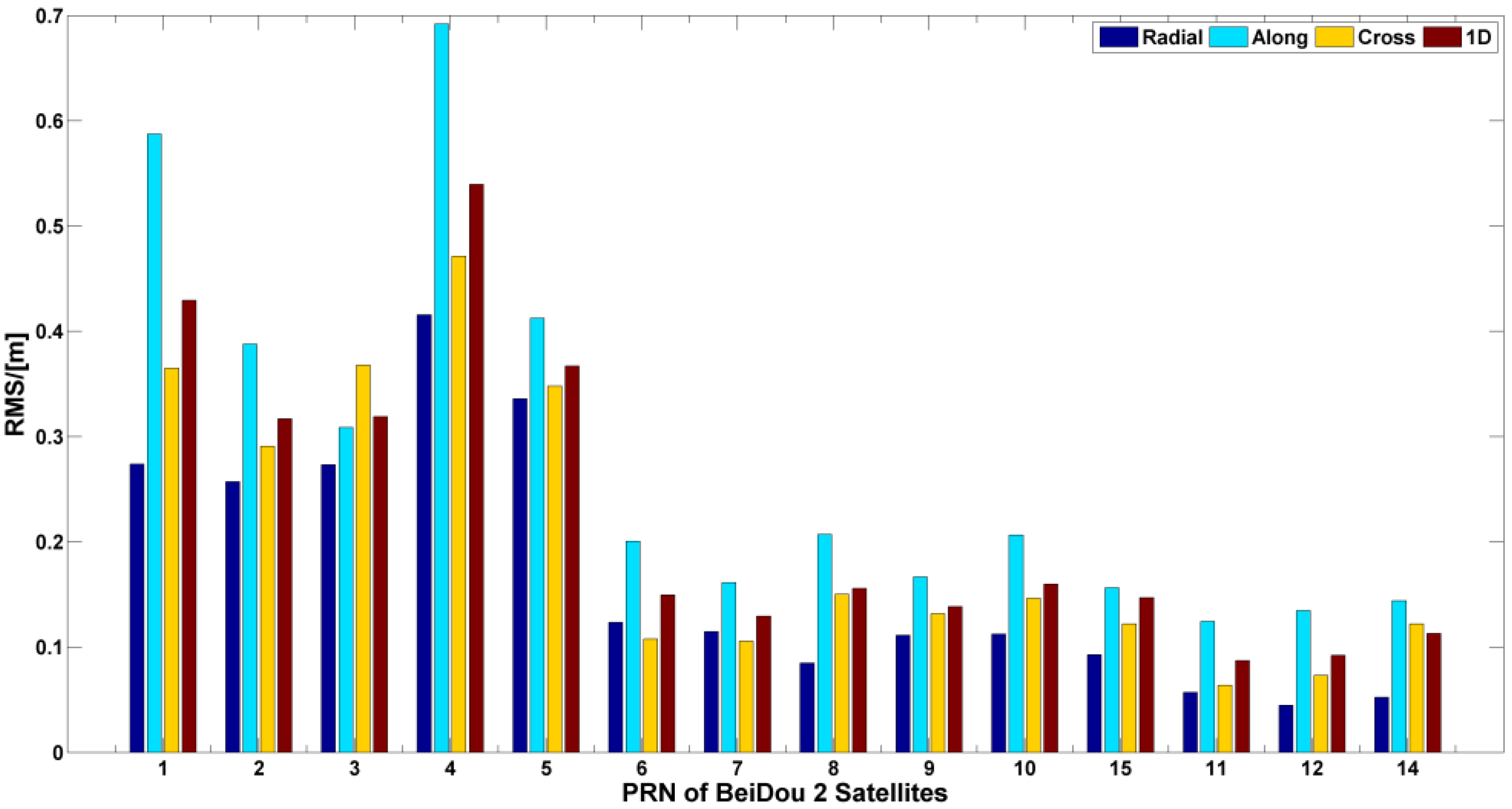
| PRN of BeiDou Satellites | Radial (cm) | Along(cm) | Cross-track (cm) |
|---|---|---|---|
| BeiDou-3 C31 (IGSO) | 12.51 | 24.95 | 23.82 |
| BeiDou-3 C32 (IGSO) | 11.88 | 25.81 | 24.32 |
| BeiDou-3 C33 (MEO) | 40.75 | 58.67 | 51.82 |
| BeiDou-3 C34 (MEO) | 41.16 | 59.88 | 59.11 |
| BeiDou-2 C01 (GEO) | 27.39 | 58.72 | 36.49 |
| BeiDou-2 C02 (GEO) | 25.72 | 38.79 | 29.09 |
| BeiDou-2 C03 (GEO) | 27.32 | 30.87 | 36.78 |
| BeiDou-2 C04 (GEO) | 41.55 | 69.19 | 47.12 |
| BeiDou-2 C05 (GEO) | 33.58 | 41.25 | 34.81 |
| BeiDou-2 C06 (IGSO) | 12.35 | 20.05 | 10.77 |
| BeiDou-2 C07 (IGSO) | 11.46 | 16.12 | 10.57 |
| BeiDou-2 C08 (IGSO) | 8.49 | 20.71 | 15.03 |
| BeiDou-2 C09 (IGSO) | 11.12 | 16.67 | 13.17 |
| BeiDou-2 C10 (IGSO) | 11.23 | 20.65 | 14.65 |
| BeiDou-2 C15 (IGSO) | 9.26 | 15.63 | 12.21 |
| BeiDou-2 C11 (MEO) | 5.69 | 12.45 | 6.37 |
| BeiDou-2 C12 (MEO) | 4.46 | 13.46 | 7.31 |
| BeiDou-2 C14 (MEO) | 5.22 | 14.41 | 12.19 |
| PRN of BeiDou Satellites | Mean (cm) | RMS (cm) |
|---|---|---|
| BeiDou-3 C31 (IGSO) | −3.82 | 11.25 |
| BeiDou-3 C32 (IGSO) | −3.51 | 11.28 |
| BeiDou-3 C33 (MEO) | 15.64 | 38.61 |
| BeiDou-3 C34 (MEO) | 15.44 | 40.26 |
| BeiDou-2 C01 (GEO) | −2.68 | 27.98 |
| BeiDou-2 C08 (IGSO) | −4.27 | 8.51 |
| BeiDou-2 C10 (IGSO) | −4.97 | 10.32 |
| BeiDou-2 C11 (MEO) | 2.92 | 5.91 |
© 2016 by the authors; licensee MDPI, Basel, Switzerland. This article is an open access article distributed under the terms and conditions of the Creative Commons Attribution (CC-BY) license (http://creativecommons.org/licenses/by/4.0/).
Share and Cite
Tan, B.; Yuan, Y.; Wen, M.; Ning, Y.; Liu, X. Initial Results of the Precise Orbit Determination for the New-Generation BeiDou Satellites (BeiDou-3) Based on the iGMAS Network. ISPRS Int. J. Geo-Inf. 2016, 5, 196. https://doi.org/10.3390/ijgi5110196
Tan B, Yuan Y, Wen M, Ning Y, Liu X. Initial Results of the Precise Orbit Determination for the New-Generation BeiDou Satellites (BeiDou-3) Based on the iGMAS Network. ISPRS International Journal of Geo-Information. 2016; 5(11):196. https://doi.org/10.3390/ijgi5110196
Chicago/Turabian StyleTan, Bingfeng, Yunbin Yuan, Mingyue Wen, Yafei Ning, and Xifeng Liu. 2016. "Initial Results of the Precise Orbit Determination for the New-Generation BeiDou Satellites (BeiDou-3) Based on the iGMAS Network" ISPRS International Journal of Geo-Information 5, no. 11: 196. https://doi.org/10.3390/ijgi5110196
APA StyleTan, B., Yuan, Y., Wen, M., Ning, Y., & Liu, X. (2016). Initial Results of the Precise Orbit Determination for the New-Generation BeiDou Satellites (BeiDou-3) Based on the iGMAS Network. ISPRS International Journal of Geo-Information, 5(11), 196. https://doi.org/10.3390/ijgi5110196