The Influence of Surface Roughness on GIS-Based Solar Radiation Modelling

Abstract
1. Introduction
2. Materials and Methods
2.1. Case Studies and Data Used
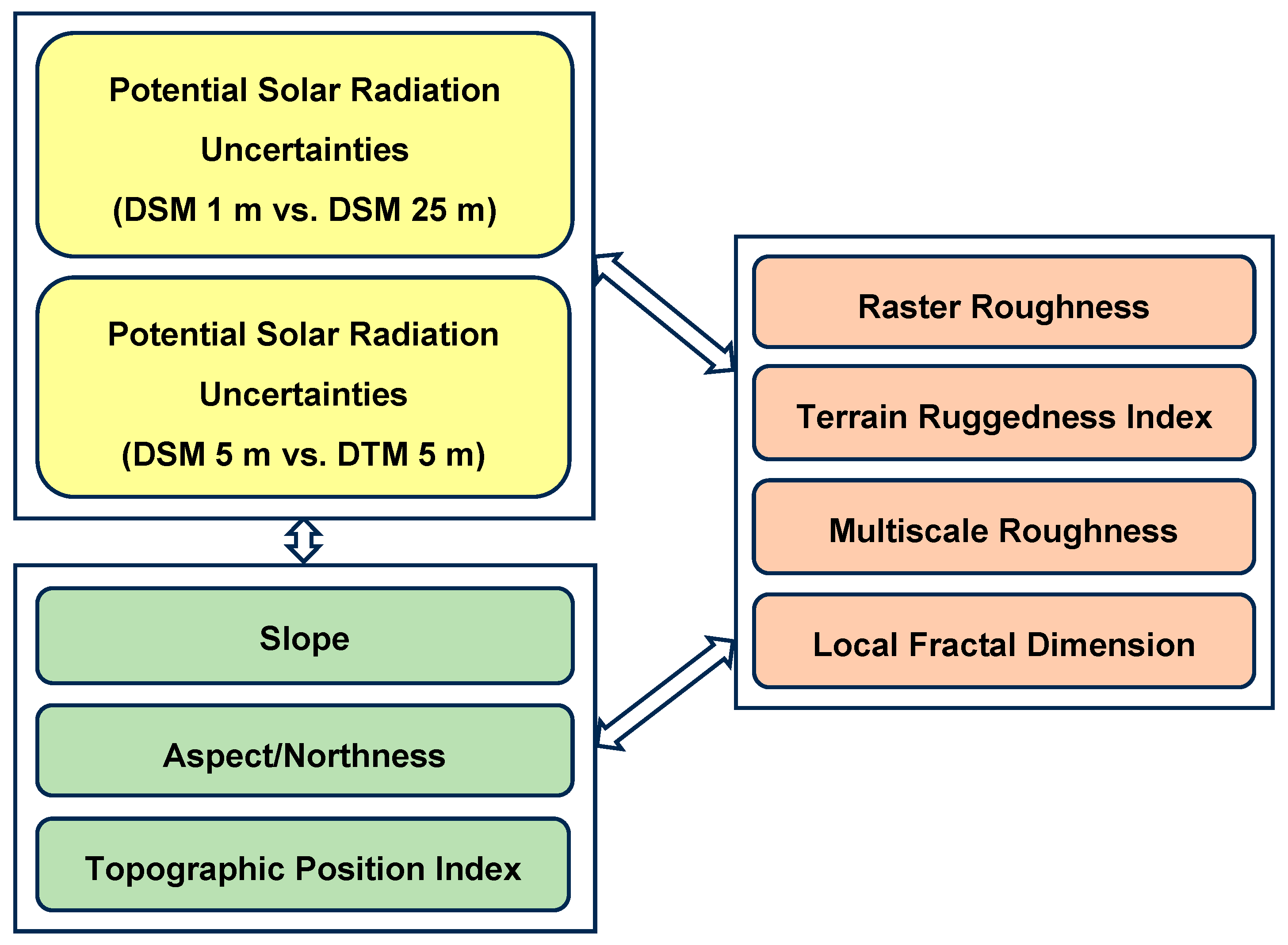
2.2. Design of the Experiment
2.3. Calculation of Basic Elevation-Derived Terrain Parameters
2.3.1. Slope, Aspect, and Northness
2.3.2. Topographic Position Index
2.4. Calculation of the Terrain or Surface Roughness
2.4.1. Raster Roughness (GDAL/QGIS)
2.4.2. Terrain Ruggedness Index (SAGA/QGIS, ArcGIS)
2.4.3. Multiscale Roughness (WhiteboxTools/QGIS)
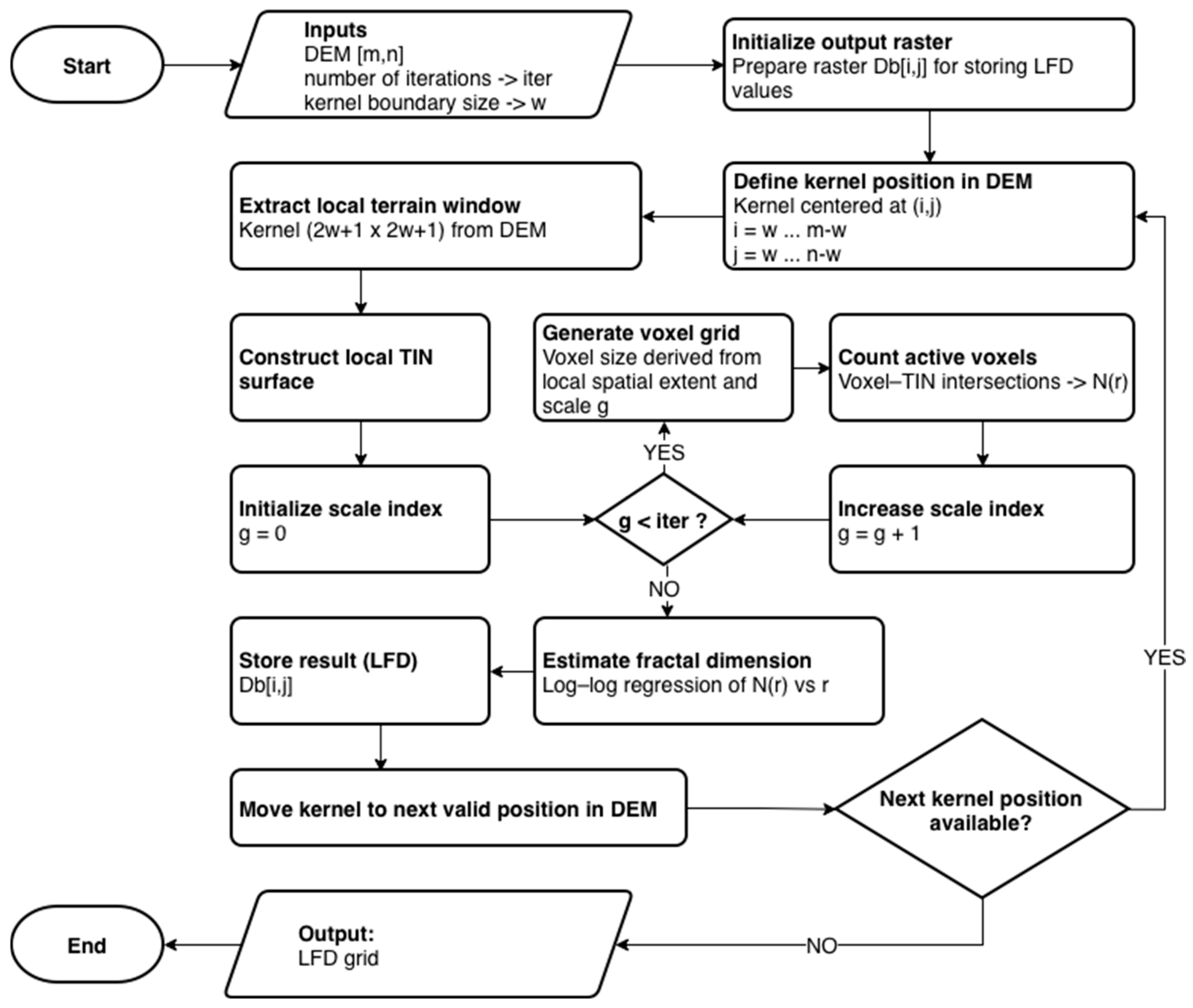
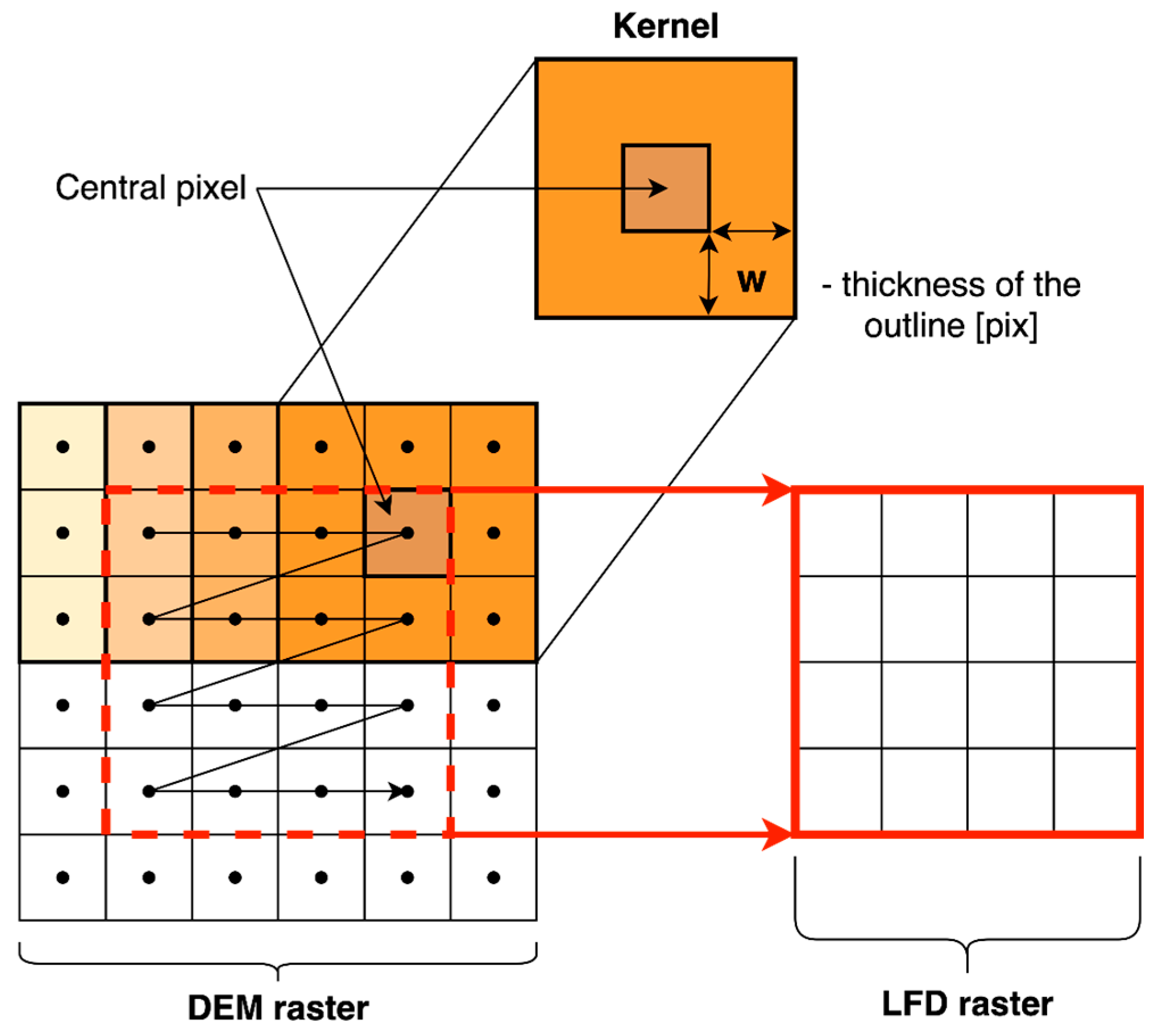
2.5. Fractal Dimension and Its Relevance in Terrain Surface Analysis
2.6. Potential Solar Radiation
2.7. Cross-Correlation Analysis of Terrain Parameters, Surface Roughness, and Uncertainties in PSR Calculation
2.8. Surface Reclassification and Clustering by Roughness
3. Results
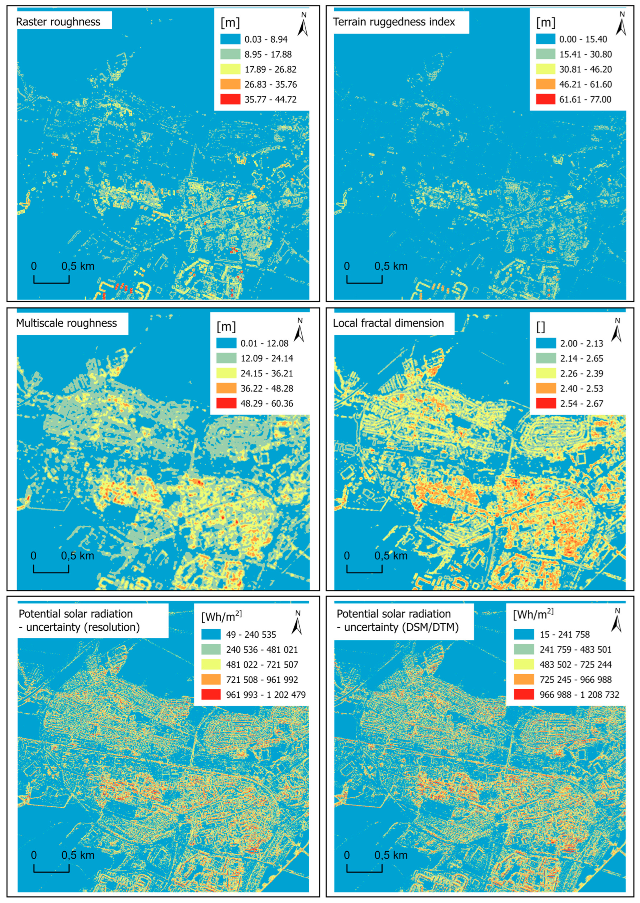
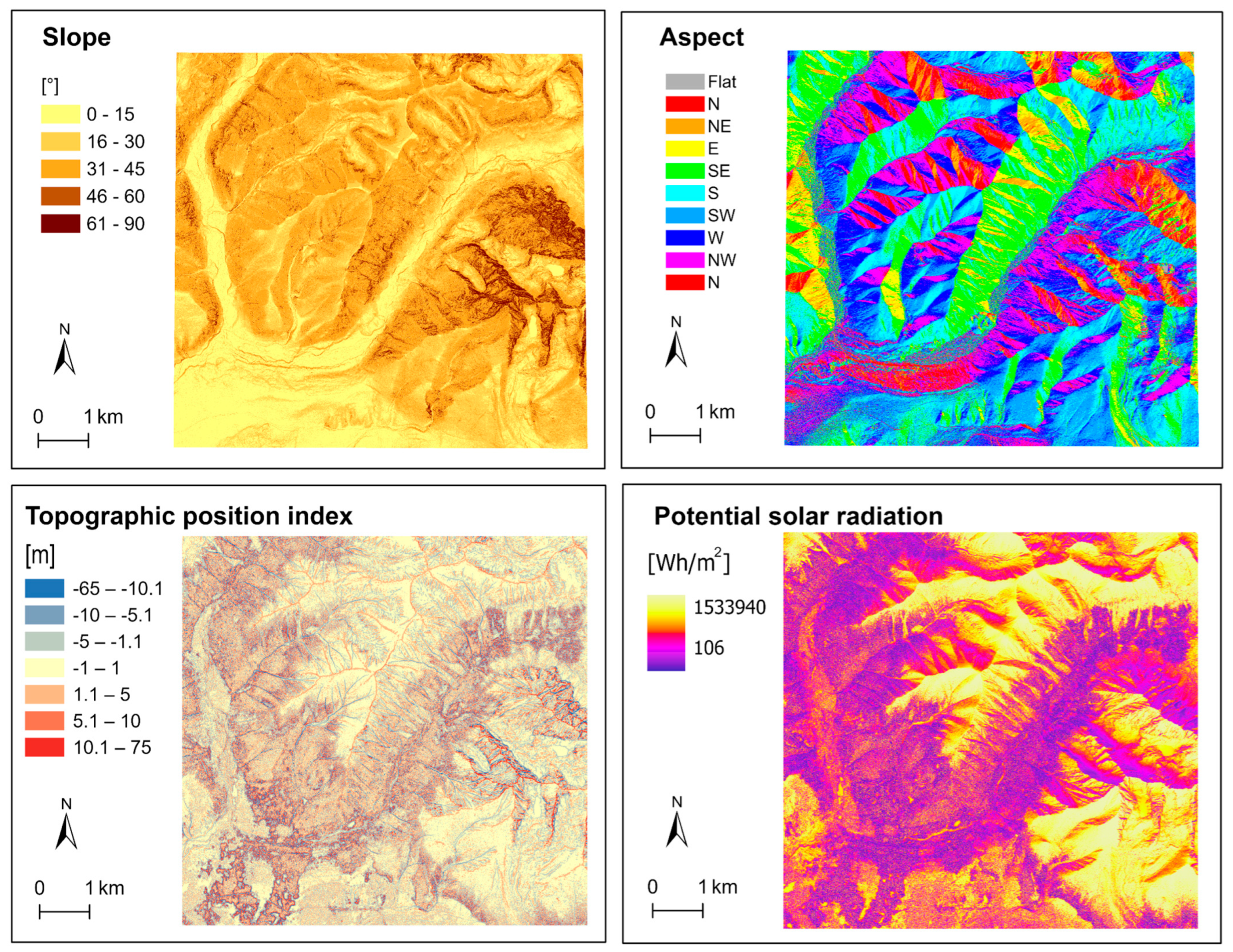
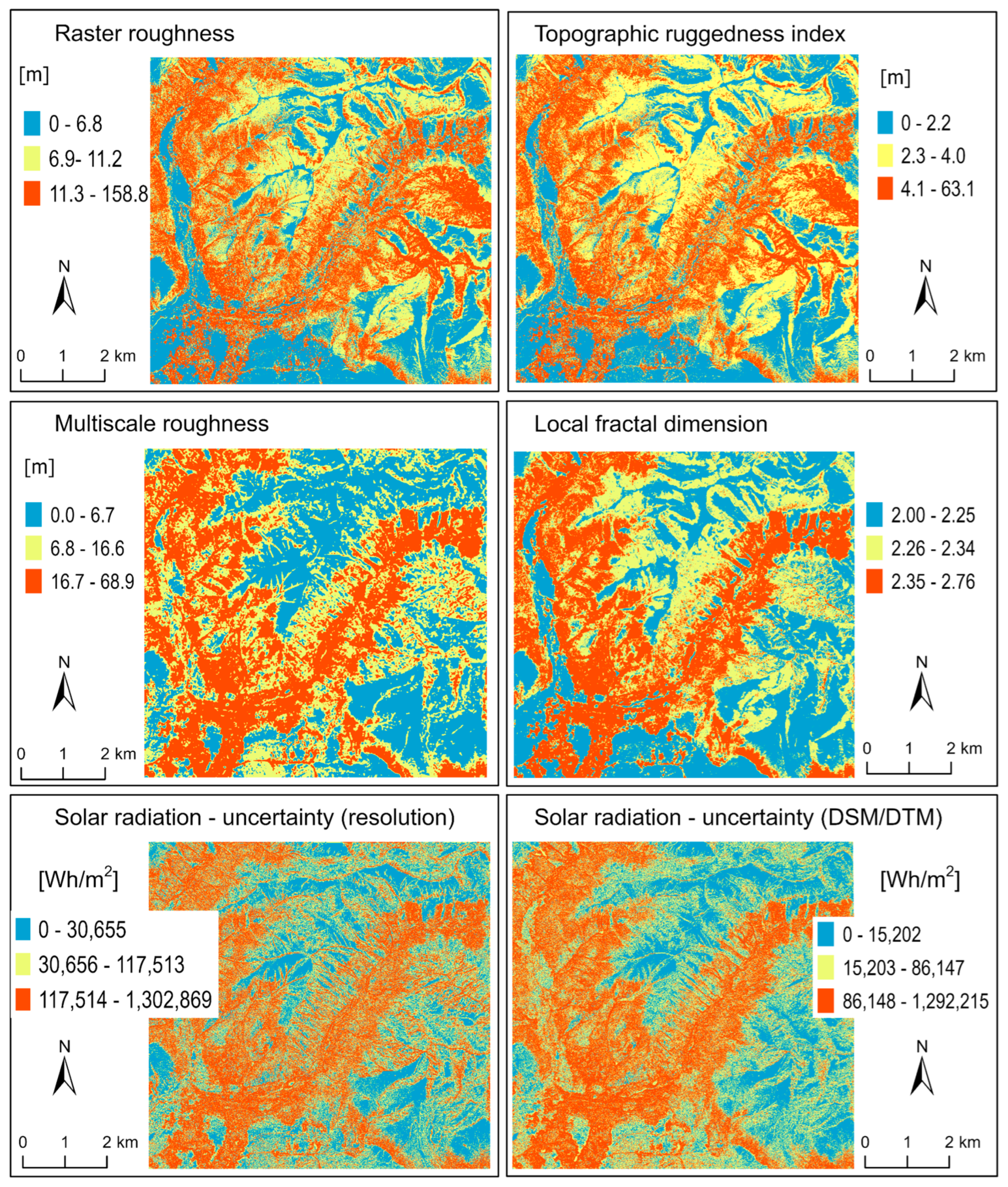
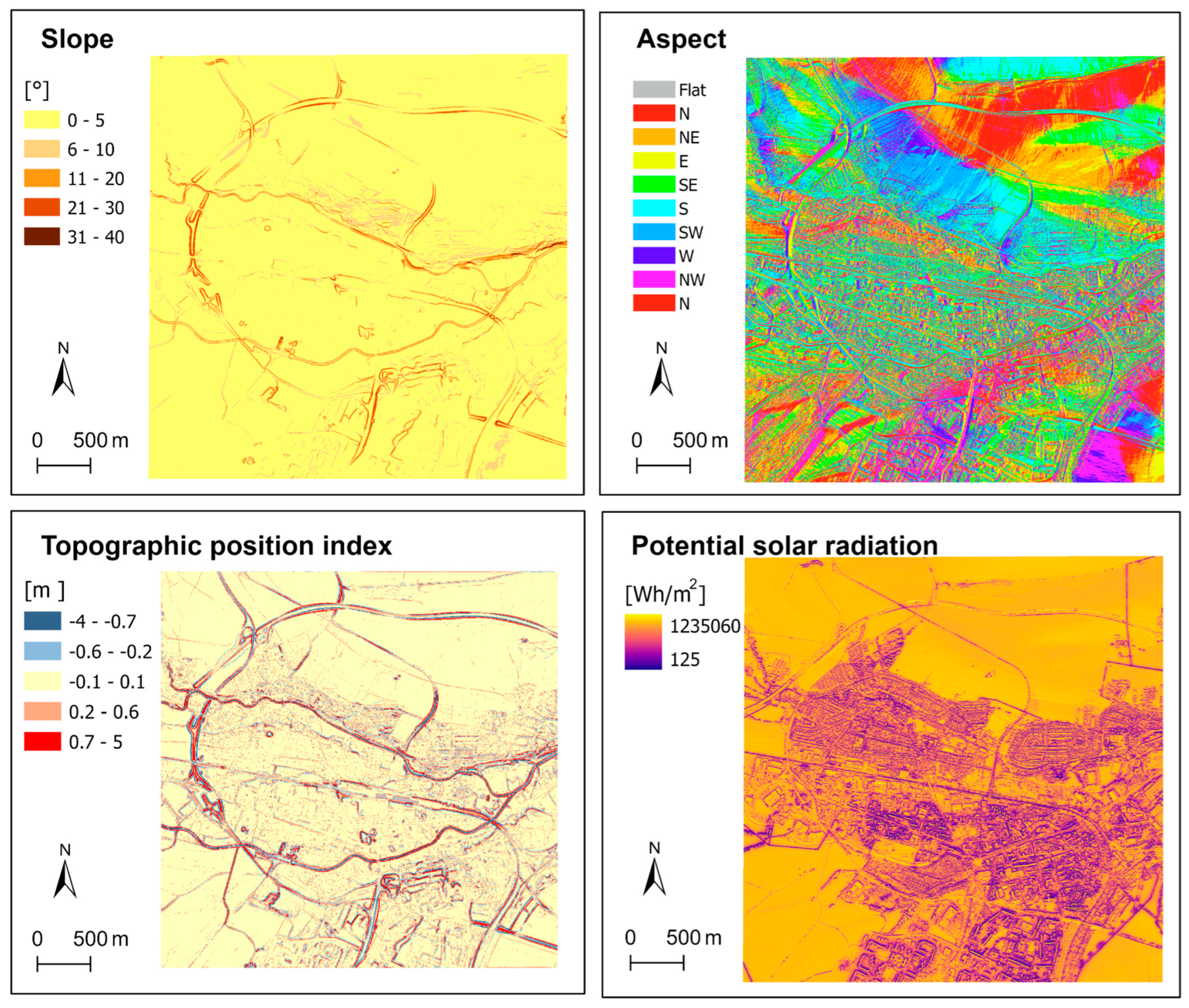
3.1. Terrain Parameters, Surface Roughness, and PSR Calculations
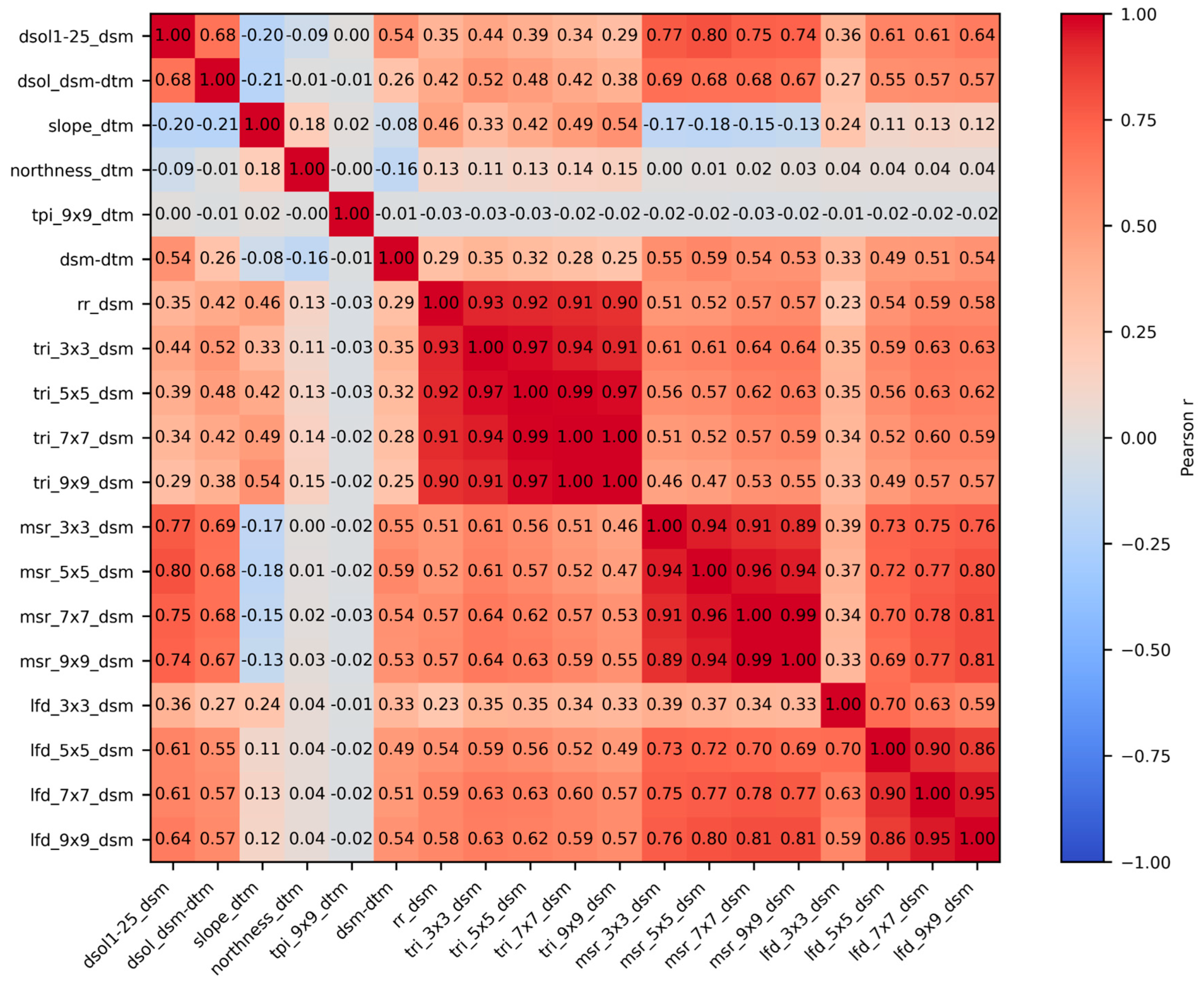
3.2. Calculating Correlations and Multicollinearity Tests
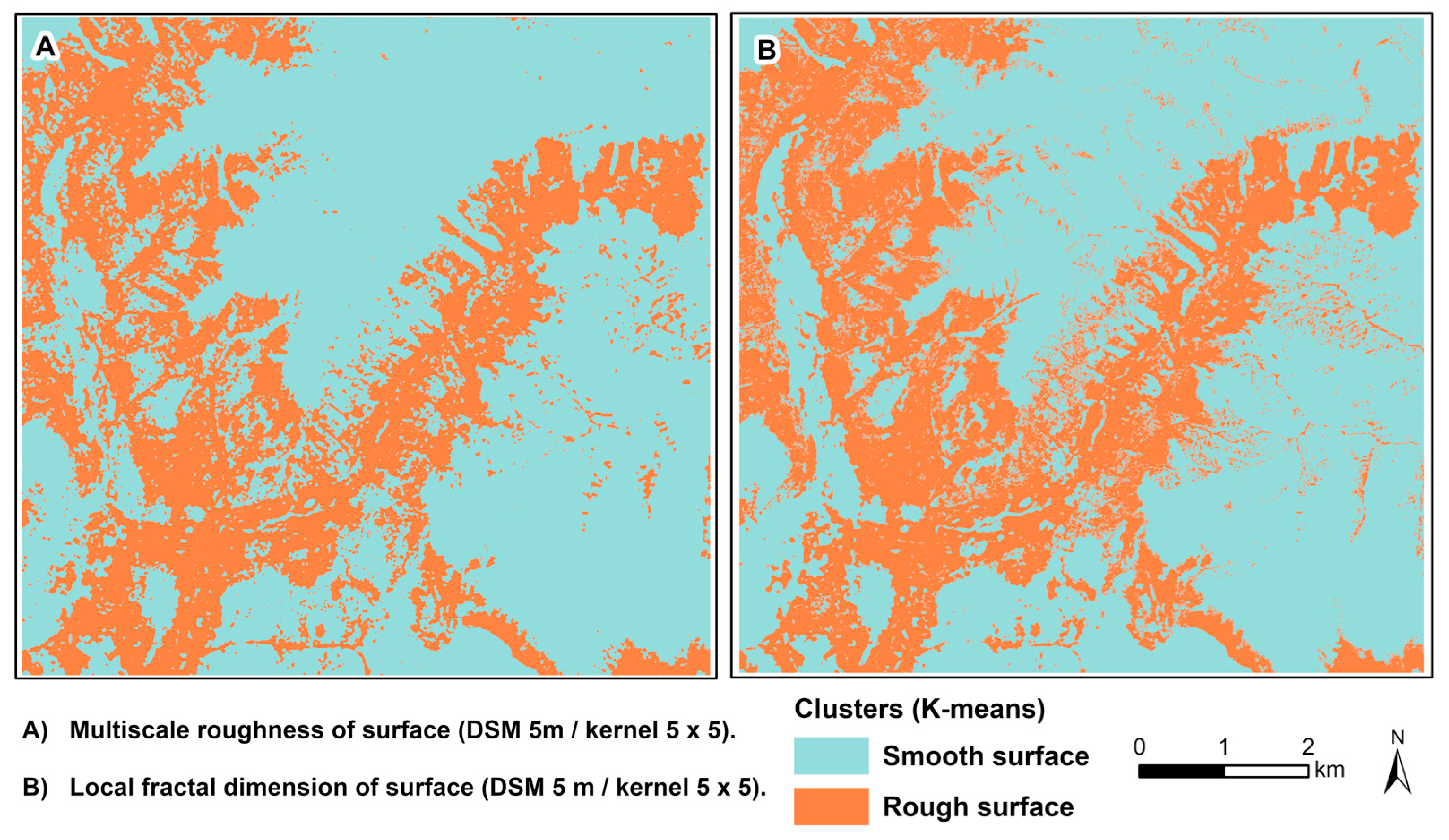
3.3. Clustering and Reclassification
4. Discussion
4.1. Modelling Surface Roughness in GIS
4.2. LFD as a New Roughness Parameter
4.3. Assessment of the Impact of Surface Roughness on Potential Solar Radiation Calculation
5. Conclusions
Supplementary Materials
Author Contributions
Funding
Data Availability Statement
Acknowledgments
Conflicts of Interest
Abbreviations
| ALS | Airborne laser scanning |
| ASR | Area solar radiation |
| DSM | Digital surface model |
| DTM | Digital terrain model |
| FD | Fractal dimension |
| GCCA SR | Geodesy, Cartography and Cadastre Authority of the Slovak Republic |
| GIS | Geographical information system |
| GKÚ | Geodetic and Cartographic Institute Bratislava (in Slovak) |
| LFD | Local fractal dimension |
| MSR | Multiscale roughness |
| PCSRT | Point cloud solar radiation tool |
| PSR | Potential solar radiation |
| RMS | Root-mean-square |
| RR | Raster roughness |
| TPI | Topographic position index |
| TRI | Terrain ruggedness index |
| ÚGKK SR | Geodesy, Cartography and Cadastre Authority of the Slovak Republic (in Slovak) |
| VIF | Variance inflation factor |
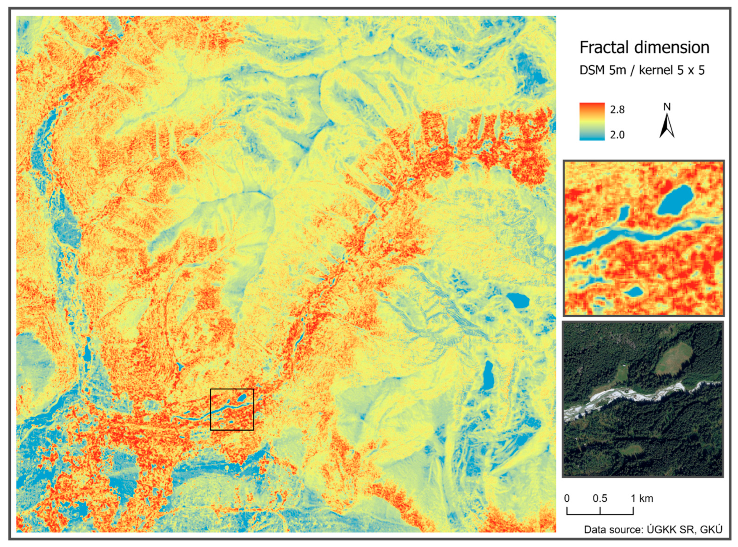
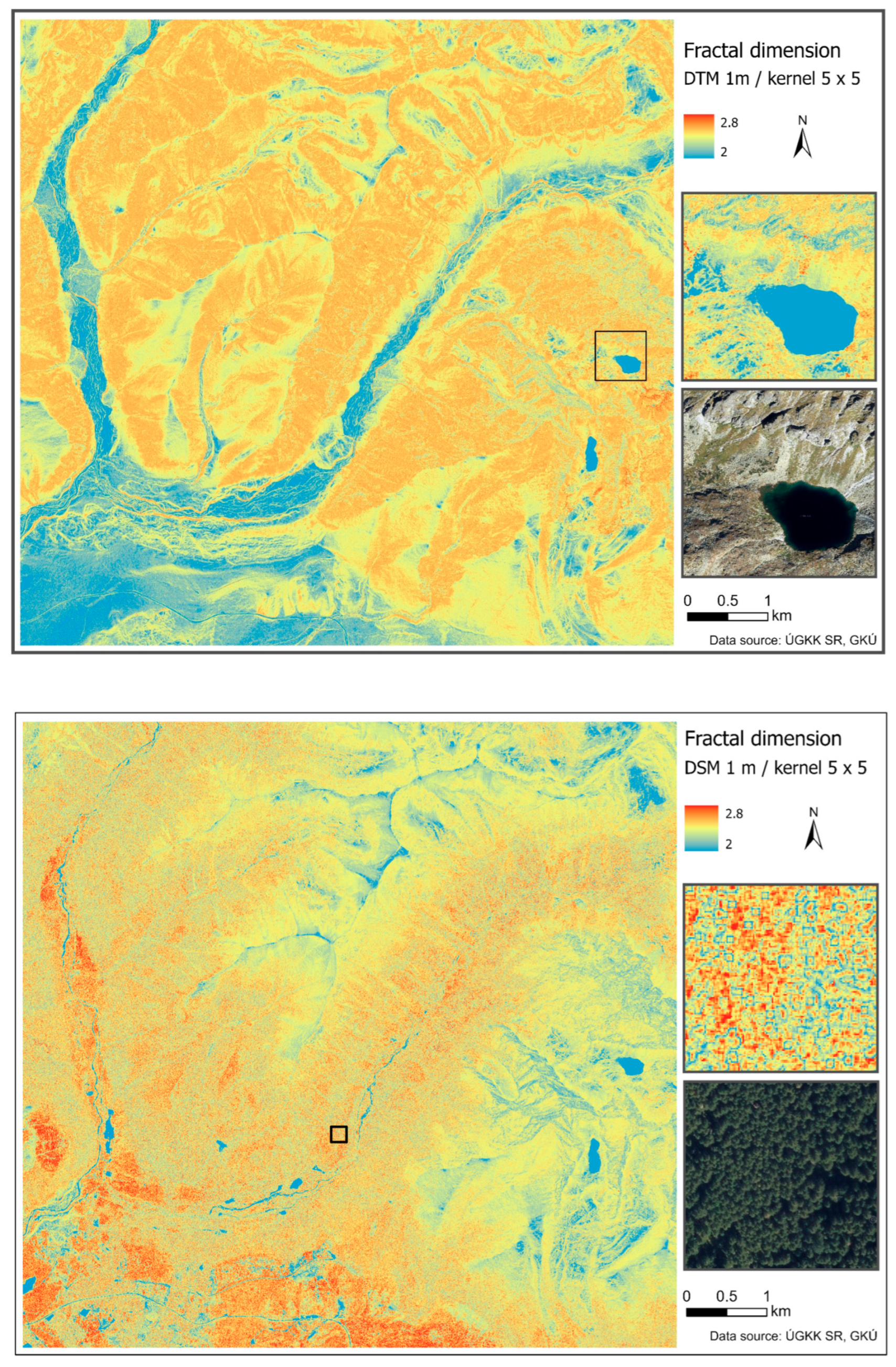
Appendix A. Visualisation of Local Fractal Dimension (LFD) Calculated Based on Digital Terrain Model (DTM) and Digital Surface Model (DSM)
References
- Tovar-Pescador, J.; Pozo-Vázquez, D.; Ruiz-Arias, J.A.; Batlles, J.; López, G.; Bosch, J.L. On the use of the digital elevation model to estimate the solar radiation in areas of complex topography. Meteorol. Appl. 2006, 13, 279–287. [Google Scholar] [CrossRef] [Scilit]
- Aguilar, C.; Herrero, J.; Polo, M.J. Topographic effects on solar radiation distribution in mountainous watersheds and their influence on reference evapotranspiration estimates at watershed scale. Hydrol. Earth Syst. Sci. 2010, 14, 2479–2494. [Google Scholar] [CrossRef] [Scilit]
- Flint, A.L.; Childs, S.W. Calculation of solar radiation in mountainous terrain. Agric. For. Meteorol. 1987, 40, 233–249. [Google Scholar] [CrossRef] [Scilit]
- Witzmann, S.; Gollob, C.; Kraßnitzer, R.; Ritter, T.; Tockner, A.; Schume, H.; Nothdurft, A. Modeling of solar radiation and sub-canopy light regime on forest inventory plots of mixed conifer and deciduous temperate forests using point clouds from personal laser scanning. For. Ecol. Manag. 2024, 569, 122166. [Google Scholar] [CrossRef] [Scilit]
- Buchalová, D.; Hofierka, J.; Šupinský, J.; Kaňuk, J. Estimating subcanopy solar radiation using point clouds and GIS-Based solar radiation models. Remote Sens. 2025, 17, 328. [Google Scholar] [CrossRef] [Scilit]
- Cenky, M.; Bendik, J.; Janiga, P.; Lazarenko, I. Urban-Scale Rooftop Photovoltaic Potential Estimation Using Open-Source Software and Public GIS Datasets. Smart Cities 2024, 7, 3962–3982. [Google Scholar] [CrossRef] [Scilit]
- Wilson, M.F.J.; O’Connell, B.; Brown, C.; Guinan, J.C.; Grehan, A.J. Multiscale Terrain Analysis of Multibeam Bathymetry Data for Habitat Mapping on the Continental Slope. Mar. Geod. 2007, 30, 3–35. [Google Scholar] [CrossRef] [Scilit]
- Riley, S.J.; De Gloria, S.D.; Elliot, R. A Terrain Ruggedness that Quantifies Topographic Heterogeneity. Intermt. J. Sci. 1999, 5, 23–27. [Google Scholar]
- Grohmann, C.H.; Smith, M.J.; Riccomini, C. Multiscale analysis of topographic surface roughness in the Midland Valley, Scotland. IEEE Trans. Geosci. Remote Sens. 2010, 49, 1200–1213. [Google Scholar] [CrossRef] [Scilit]
- Hani, A.F.M.; Sathyamoorthy, D.; Asirvadam, V.S. A method for computation of surface roughness of digital elevation model terrains via multiscale analysis. Comput. Geosci. 2011, 37, 177–192. [Google Scholar] [CrossRef] [Scilit]
- Smith, M.W. Roughness in the Earth sciences. Earth-Sci. Rev. 2014, 136, 202–225. [Google Scholar] [CrossRef] [Scilit]
- Lindsay, J.B.; Newman, D.R. Hyper-scale analysis of surface roughness. PeerJ Prepr. 2018, 6, e27110v1. [Google Scholar]
- Lindsay, J.B.; Newman, D.R.; Francioni, A. Scale-Optimized surface roughness for topographic analysis. Geosciences 2019, 9, 322. [Google Scholar] [CrossRef] [Scilit]
- Brožová, N.; Baggio, T.; D’Agostino, V.; Bühler, Y.; Bebi, P. Multiscale analysis of surface roughness for the improvement of natural hazard modelling. Nat. Hazards Earth Syst. Sci. 2021, 21, 3539–3562. [Google Scholar] [CrossRef] [Scilit]
- Ič, T. Local Modelling of the Fractal Dimension on Digital Elevation Models. In Juniorstav 2024: Proceedings 26th International Scientific Conference of Civil Engineering; Brno University of Technology, Faculty of Civil Engineering: Brno, Czech Republic, 2024; pp. 1–9. ISBN 978-80-86433-83-7. [Google Scholar] [CrossRef] [Scilit]
- Xu, T.; More, D.M.; Gallant, J.C. Fractals, Fractal Dimensions and Landscapes—A review. Geomorphology 1993, 8, 245–262. [Google Scholar] [CrossRef] [Scilit]
- Huang, J.; Turcotte, D.L. Fractal image analysis: Application to the topography of Oregon and synthetic images. J. Opt. Soc. Am. A 1990, 7, 1124–1130. [Google Scholar] [CrossRef] [Scilit]
- Hagerhall, C.M.; Purcell, T.; Taylor, R. Fractal dimension of landscape silhouette outlines as a predictor of landscape preference. J. Environ. Psychol. 2004, 24, 247–255. [Google Scholar] [CrossRef] [Scilit]
- Goff, J.A.; Tucholke, B.E. Multiscale spectral analysis of bathymetry on the flank of the Mid-Atlantic Ridge: Modification of the seafloor by mass wasting and sedimentation. J. Geophys. Res. 1997, 102, 15447–15462. [Google Scholar] [CrossRef] [Scilit]
- Gagnon, J.S.; Lovejoy, S.; Schertzer, D. Multifractal earth topography. Nonlinear Process. Geophys. 2006, 13, 541–570. [Google Scholar] [CrossRef] [Scilit]
- Schmittbuhl, J.; Vilotte, J.-P.; Roux, S. Reliability of self-affine measurements. Phys. Rev. E 1995, 51, 131–147. [Google Scholar] [CrossRef] [Scilit]
- Lee, J.H.; Kim, H. The impact of Sentinel-1-Corrected fractal roughness on soil moisture retrievals. Fractal Fract. 2024, 8, 137. [Google Scholar] [CrossRef] [Scilit]
- Simion, A.G.; Andronache, I.; Ahammer, H.; Marin, M.; Loghin, V.; Nedelcu, I.D.; Popa, C.M.; Peptenatu, D.; Jelinek, H.F. Particularities of forest dynamics using Higuchi Dimension. Parâng Mountains as a case study. Fractal Fract. 2021, 5, 96. [Google Scholar] [CrossRef] [Scilit]
- Zou, Z.; Du, Y.; Song, H. Fractal Features in Terrain Restoration of Jiuzhai Valley, a World Natural Heritage Site in China. Fractal Fract. 2023, 7, 863. [Google Scholar] [CrossRef] [Scilit]
- Cheng, L.; Feng, R.; Wang, L. Fractal Characteristic Analysis of Urban Land-Cover Spatial Patterns with Spatiotemporal Remote Sensing Images in Shenzhen City (1988–2015). Remote Sens. 2021, 13, 4640. [Google Scholar] [CrossRef] [Scilit]
- Karpinski, M.; Kuznichenko, S.; Kazakova, N.; Fraze-Frazenko, O.; Jancarczyk, D. Geospatial Assessment of the Territorial Road Network by Fractal Method. Future Internet 2020, 12, 201. [Google Scholar] [CrossRef] [Scilit]
- Pei, S.; Wang, J.; Wang, W. The Impact of Terrain on the Planar Spatial Morphology of Mountain Settlements Studied Using Fractal Dimensions. Appl. Sci. 2025, 15, 3046. [Google Scholar] [CrossRef] [Scilit]
- Aguado, P.L.; Del Monte, J.P.; Moratiel, R.; Tarquis, A.M. Spatial Characterization of Landscapes through Multifractal Analysis of DEM. Sci. World J. 2014, 2024, 563038. [Google Scholar] [CrossRef] [Scilit]
- Chen, Y. Fractal modeling and Fractal Dimension Description of urban Morphology. Entropy 2020, 22, 961. [Google Scholar] [CrossRef] [Scilit]
- Batty, M.; Longley, M. Fractal Cities—A Geometry of Form and Function; Academic Press: London, UK, 1994. [Google Scholar]
- Chen, Y. The solutions to the uncertainty problem of urban fractal dimension Calculation. Entropy 2019, 21, 453. [Google Scholar] [CrossRef] [Scilit] [PubMed]
- Glenn, N.F.; Streutker, D.R.; Chadwick, D.J.; Thackray, G.D.; Dorsch, S.J. Analysis of LiDAR-derived topographic information for characterizing and differentiating landslide morphology and activity. Geomorphology 2006, 73, 131–148. [Google Scholar] [CrossRef] [Scilit]
- Tara, A.; Patuano, A.; Lawson, G. Between 2D and 3D: Studying structural complexity of urban fabric using Voxels and LIDAR-Derived DSMs. Fractal Fract. 2021, 5, 227. [Google Scholar] [CrossRef] [Scilit]
- Harrouni, S. Fractal Classification of Typical Meteorological Days from Global Solar Irradiance: Application to Five Sites of Different Climates. In Modeling Solar Radiation at the Earth’s Surface; Springer: Berlin/Heidelberg, Germany, 2008; pp. 29–54. [Google Scholar] [CrossRef] [Scilit]
- Rodríguez-Gómez, B.A.; Del Carmen Meizoso-López, M.; Mirás-Avalos, J.M.; García-Tomillo, A.; Paz-González, A. Assessment of solar irradiation models in A Coruña by multifractal analysis. Vadose Zone J. 2013, 12, vzj2012.0183. [Google Scholar] [CrossRef] [Scilit]
- Gonzalez-Arbescu, J.M.; Romeu, E. On the influence of fractal dimension on radiation efficiency and quality factor of self-resonant prefractal wire monopoles. In Proceedings of the IEEE Antennas and Propagation Society International Symposium, Columbus, OH, USA, 22–27 June 2003; Volume 4, pp. 214–217. [Google Scholar] [CrossRef] [Scilit]
- Ďuračiová, R.; Pružinec, F. Effects of Terrain Parameters and Spatial Resolution of a Digital Elevation Model on the Calculation of Potential Solar Radiation in the Mountain Environment: A Case Study of the Tatra Mountains. ISPRS Int. J. Geo-Inf. 2022, 11, 389. [Google Scholar] [CrossRef] [Scilit]
- Anderson, E.S.; Thompson, J.A.; Austin, R.E. LIDAR density and linear interpolator effects on elevation estimates. Int. J. Remote Sens. 2005, 26, 3889–3900. [Google Scholar] [CrossRef] [Scilit]
- Hofierka, J.; Kaňuk, J. Assessment of photovoltaic potential in urban areas using open-source solar radiation tools. Renew. Energy 2009, 34, 2206–2214. [Google Scholar] [CrossRef] [Scilit]
- Cathles, L.M.; Abbot, D.S.; Bassis, J.N.; MacAyeal, D.R. Modeling surface-roughness/solar-ablation feedback: Application to small-scale surface channels and crevasses of the Greenland ice sheet. Ann. Glaciol. 2011, 52, 99–108. [Google Scholar] [CrossRef] [Scilit]
- Feng, Y.; Yao, G.; Xu, J.; Wang, L.; Liu, G. Effect of surface roughness on the solar evaporation of liquid marbles. J. Colloid Interface Sci. 2022, 629, 644–653. [Google Scholar] [CrossRef] [Scilit]
- Zhang, Y.; Li, X.; Chang, X.; Luo, D.; Wang, X.; Cheng, G. Impacts of topographic shadows cast by surrounding terrain on the solar irradiance on glaciers’ surface in High Mountain Asia (HMA). Atmos. Res. 2024, 307, 107511. [Google Scholar] [CrossRef] [Scilit]
- Mezei, P.; Potterf, M.; Škvarenina, J.; Rasmussen, J.G.; Jakuš, R. Potential solar radiation as a driver for bark beetle infestation on a landscape scale. Forests 2019, 10, 604. [Google Scholar] [CrossRef] [Scilit]
- GCCA, SR. Geoportal. Available online: https://www.skgeodesy.sk/sk/ (accessed on 12 December 2024).
- GKÚ. LiDAR—Mračno Bodov (LOT26—Tatry) Metadata Record for Spatial Dataset/Series. Available online: https://rpi.gov.sk/en/metadata/da2fbb0d-4a91-4860-9f52-1c4e8ae47708 (accessed on 25 February 2026).
- ESRI. Slope (Spatial Analyst). ArcGIS Pro 3.3. Available online: https://pro.arcgis.com/en/pro-app/3.3/tool-reference/spatial-analyst/slope.htm (accessed on 21 May 2025).
- ESRI. Aspect (Spatial Analyst). ArcGIS Pro 3.5. Available online: https://pro.arcgis.com/en/pro-app/latest/tool-reference/spatial-analyst/aspect.htm (accessed on 21 May 2025).
- Weiss, A. Topographic Position and Landforms Analysis. In Proceedings of the Poster Presentation, ESRI User Conference, San Diego, CA, USA, 9–13 July 2001; Available online: https://www.jennessent.com/downloads/TPI-poster-TNC_18x22.pdf (accessed on 30 March 2026).
- Berti, M.; Corsini, A.; Daehne, A. Comparative analysis of surface roughness algorithms for the identification of active landslides. Geomorphology 2013, 182, 1–18. [Google Scholar] [CrossRef] [Scilit]
- GDAL. GDAL Raster Roughness. Available online: https://gdal.org/en/stable/programs/gdal_raster_roughness.html (accessed on 25 July 2025).
- Trevisani, S.; Teza, G.; Guth, P.L. Hacking the topographic ruggedness index. Geomorphology 2023, 439, 108838. [Google Scholar] [CrossRef] [Scilit]
- ESRI Analytics Team. Terrain Ruggedness Index (TRI). Available online: https://hub.arcgis.com/content/28360713391948af9303c0aeabb45afd/about (accessed on 25 July 2025).
- Conrad, O. Module Terrain Ruggedness Index (TRI). 2010. Available online: https://saga-gis.sourceforge.io/saga_tool_doc/2.2.1/ta_morphometry_16.html (accessed on 25 July 2025).
- Lindsay, J. Whitebox GAT: A case study in geomorphometric analysis. Comput. Geosci. 2016, 95, 75–84. [Google Scholar] [CrossRef] [Scilit]
- Lindsay, J. MultiscaleRoughness. WhiteboxTools User Manual. 2018. Available online: https://www.whiteboxgeo.com/manual/wbt_book/available_tools/geomorphometric_analysis.html#MultiscaleRoughness (accessed on 30 March 2026).
- Addison, P.S. Fractals and Chaos: An Illustrated Course; Institute of Physics Publishing: Bristol, UK; Philadelphia, PA, USA, 1997; 268p. [Google Scholar]
- Peitgen, H.O.; Jürgens, H.; Saupe, D. Chaos and Fractals: New Frontiers of Science; Springer: New York, NY, USA, 1992. [Google Scholar] [CrossRef] [Scilit]
- Falconer, K.J. Fractal Geometry: Mathematical Foundations and Applications, 3rd ed.; John Wiley & Sons Inc.: Hoboken, NJ, USA, 2014; 400p. [Google Scholar]
- Malleswar, S.D.; Isoda, Y.; Nakaya, T. Box Height-Independent Differential Bar Cumulation (DBC) for 3D Raster Surface Fractal Dimension Analysis. J. Geovis. Spat. Anal. 2025, 9, 13. [Google Scholar] [CrossRef] [Scilit]
- Ič, T. Object collision detection algorithm and principles of its application in solving issues in GIS. In Proceedings of the Advances in Architectural, Civil and Environmental Engineering, Bratislava, Slovakia, 13 October 2021; Slovak University of Technology in Bratislava: Bratislava, Slovakia, 2021; pp. 173–182. (In Slovak) [Google Scholar]
- Delaunay, B. Sur la sphre vide. A la mmoire de Georges Vorono. Bull. Acad. Sci. URSS Cl. Sci. Math. Nat. 1934, 6, 793–800. [Google Scholar]
- Liu, S.; Chen, Y. A Three-Dimensional Box-Counting Method to Study the Fractal Characteristics of Urban Areas in Shenyang, Northeast China. Buildings 2022, 12, 299. [Google Scholar] [CrossRef] [Scilit]
- Ericson, C. Real-Time Collision Detection; Taylor & Francis: Boca Raton, FL, USA; CRC Press: Boca Raton, FL, USA, 2004; 632p. [Google Scholar]
- Akenine-Möller, T.; Haines, E.; Hoffman, N.; Pesce, A.; Ivanicki, M.; Hillaire, S. Real-Time Rendering, 4th ed.; Taylor & Francis: Boca Raton, FL, USA; CRC Press: Boca Raton, FL, USA, 2018; 1178p. [Google Scholar]
- Boyd, S.; Vandenberghe, L. Convex Optimization; University Press: Cambridge, UK, 2009; pp. 46–50. [Google Scholar]
- ESRI. ArcGIS Pro 3.5. Area Solar Radiation (Spatial Analyst). Available online: https://pro.arcgis.com/en/pro-app/latest/tool-reference/spatial-analyst/area-solar-radiation.htm (accessed on 21 May 2025).
- Kausika, B.B.; van Sark, W.G.J.H.M. Calibration and validation of ArcGIS solar radiation tool for photovoltaic potential determination in the Netherlands. Energies 2021, 14, 1865. [Google Scholar] [CrossRef] [Scilit]
- GRASS GIS 8.0.1dev Reference Manual r.sun—Solar Irradiance and Irradiation Model. Available online: https://grass.osgeo.org/grass80/manuals/r.sun.html (accessed on 15 May 2024).
- Hofierka, J.; Šúri, M. The solar radiation model for Open source GIS: Implementation and applications. In Proceedings of the Open Source GIS-GRASS Users Conference, Trento, Italy, 11–13 September 2002; pp. 1–19. [Google Scholar]
- Pružinec, F.; Ďuračiová, R. A Point-Cloud Solar Radiation Tool. Energies 2022, 15, 7018. [Google Scholar] [CrossRef] [Scilit]
- Snedecor, G.W.; Cochran, W.G. Statistical Methods, 6th ed.; The Iowa State University Press: Ames, IA, USA, 1968. [Google Scholar]
- ESRI. ArcGIS Pro 3.5. Band Collection Statistics (Spatial Analyst). Available online: https://pro.arcgis.com/en/pro-app/latest/tool-reference/spatial-analyst/band-collection-statistics.htm (accessed on 30 March 2026).
- Forgy, E. Cluster Analysis of Multivariate Data Efficiency versus Interpretability of Classifications. Biometrics 1965, 21, 768–780. [Google Scholar]
- Ďuračiová, R.; Muňko, M.; Barka, I.; Koreň, M.; Resnerová, K.; Holuša, J.; Blaženec, M.; Potterf, M.; Jakuš, R. A bark beetle infestation predictive model based on satellite data in the frame of decision support system TANABBO. iForest-Biogeosci. For. 2020, 13, 215–223. [Google Scholar] [CrossRef] [Scilit]
- Wang, L.; Wang, K. Impacts of DEM uncertainty on estimated surface solar radiation and extracted river network. Bull. Am. Meteorol. Soc. 2014, 96, 297–304. [Google Scholar] [CrossRef] [Scilit]


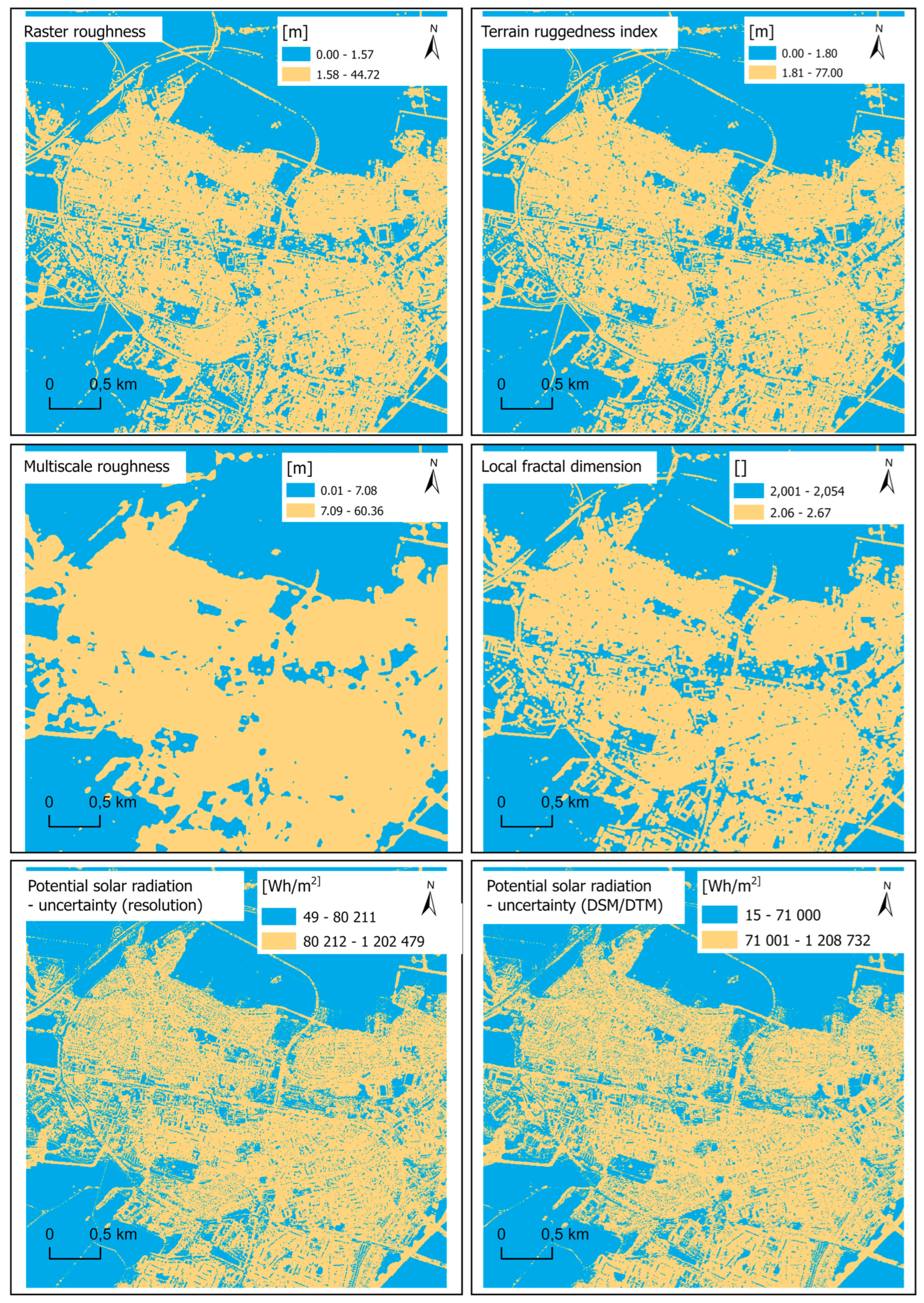




| Input Parameter | Value |
|---|---|
| Latitude [°] | 49.21231 |
| Sky size/resolution | 200 |
| Day interval | 14 |
| Hour interval | 1 |
| Calculation directions | 32 |
| Zenith divisions | 8 |
| Diffuse model type | UNIFORM SKY |
| Diffuse proportion | 0.3 |
| Transmissivity | 0.5 |
| Parameter | Description | |
|---|---|---|
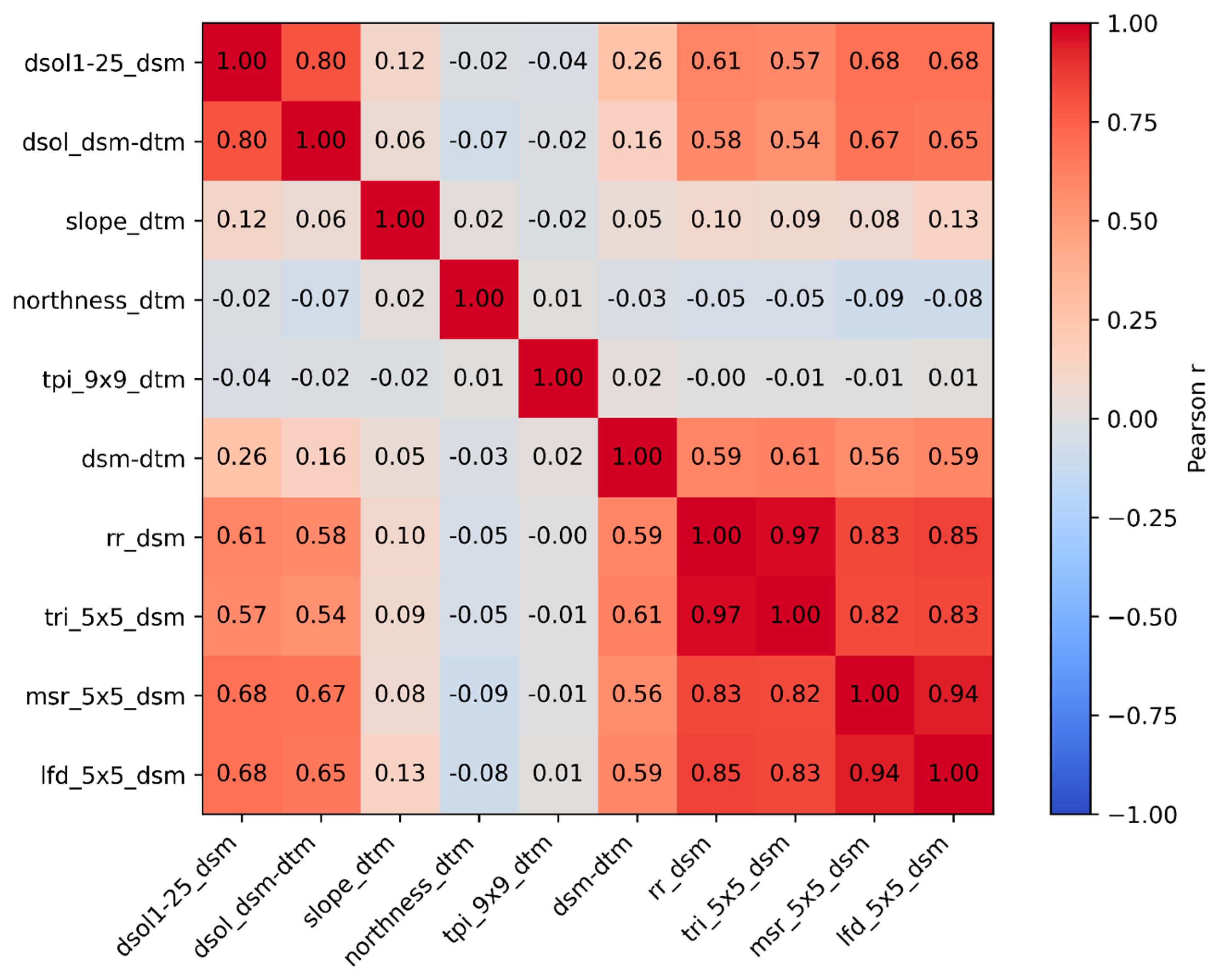
| 1 | dsol1-25_dsm | AbsPSR(1-25) [kWh/m2]—absolute value of differences in PSR (reduced resolution) calculated using DSM |
| 2 | dsol_dsm-dtm | AbsPSR(S-M) [kWh/m2]—absolute value of differences in PSR calculated using DSM and DTM |
| 3 | slope_dtm | Slope [°]; calculated using DTM |
| 4 | northness_dtm | Northness []—(cos(aspect)); calculated using DTM |
| 5 | tpi_9 × 9_dtm | TPI [m]—square kernel 9 × 9; calculated using DTM |
| 6 | dsm-dtm | Difference DSM-DTM [m]; calculated using DSM and DTM |
| 7 | rr_dsm | RR—kernel 3 × 3, calculated in QGIS using GDAL using DSM |
| 8 | tri_3 × 3_dsm | TRI—kernel 3 × 3, calculated in QGIS/SAGA using DSM |
| 9 | tri_5 × 5_dsm | TRI—kernel 5 × 5, calculated in QGIS/SAGA using DSM |
| 10 | tri_7 × 7_dsm | TRI—kernel 7 × 7, calculated in QGIS/SAGA using DSM |
| 11 | tri_9 × 9_dsm | TRI—kernel 9 × 9, calculated in QGIS/SAGA using DSM |
| 12 | msr_3 × 3_dsm | MSR—kernel 3 × 3, calculated in QGIS with WhiteboxTools using DSM |
| 13 | msr_5 × 5_dsm | MSR—kernel 5 × 5, calculated in QGIS with WhiteboxTools using DSM |
| 14 | msr_7 × 7_dsm | MSR—kernel 7 × 7, calculated in QGIS with WhiteboxTools using DSM |
| 15 | msr_9 × 9_dsm | MSR—kernel 9 × 9, calculated in QGIS with WhiteboxTools using DSM |
| 16 | lfd_3 × 3_dsm | LFD—kernel 3 × 3, calculated using the custom Python script and DSM |
| 17 | lfd_5 × 5_dsm | LFD—kernel 5 × 5, calculated using the custom Python script and DSM |
| 18 | lfd_7 × 7_dsm | LFD—kernel 7 × 7, calculated using the custom Python script and DSM |
| 19 | lfd_9 × 9_dsm | LFD—kernel 9 × 9, calculated using the custom Python script and DSM |
Disclaimer/Publisher’s Note: The statements, opinions and data contained in all publications are solely those of the individual author(s) and contributor(s) and not of MDPI and/or the editor(s). MDPI and/or the editor(s) disclaim responsibility for any injury to people or property resulting from any ideas, methods, instructions or products referred to in the content. |
© 2026 by the authors. Published by MDPI on behalf of the International Society for Photogrammetry and Remote Sensing. Licensee MDPI, Basel, Switzerland. This article is an open access article distributed under the terms and conditions of the Creative Commons Attribution (CC BY) license.
Share and Cite
Ďuračiová, R.; Ič, T.; Oberski, T. The Influence of Surface Roughness on GIS-Based Solar Radiation Modelling. ISPRS Int. J. Geo-Inf. 2026, 15, 155. https://doi.org/10.3390/ijgi15040155
Ďuračiová R, Ič T, Oberski T. The Influence of Surface Roughness on GIS-Based Solar Radiation Modelling. ISPRS International Journal of Geo-Information. 2026; 15(4):155. https://doi.org/10.3390/ijgi15040155
Chicago/Turabian StyleĎuračiová, Renata, Tomáš Ič, and Tomasz Oberski. 2026. "The Influence of Surface Roughness on GIS-Based Solar Radiation Modelling" ISPRS International Journal of Geo-Information 15, no. 4: 155. https://doi.org/10.3390/ijgi15040155
APA StyleĎuračiová, R., Ič, T., & Oberski, T. (2026). The Influence of Surface Roughness on GIS-Based Solar Radiation Modelling. ISPRS International Journal of Geo-Information, 15(4), 155. https://doi.org/10.3390/ijgi15040155