Geospatial Dasymetric Modeling and Cluster Analysis with Stability Confidence Measures for Identifying Parcel-Level Naturally Occurring Retirement Communities

Abstract
1. Introduction
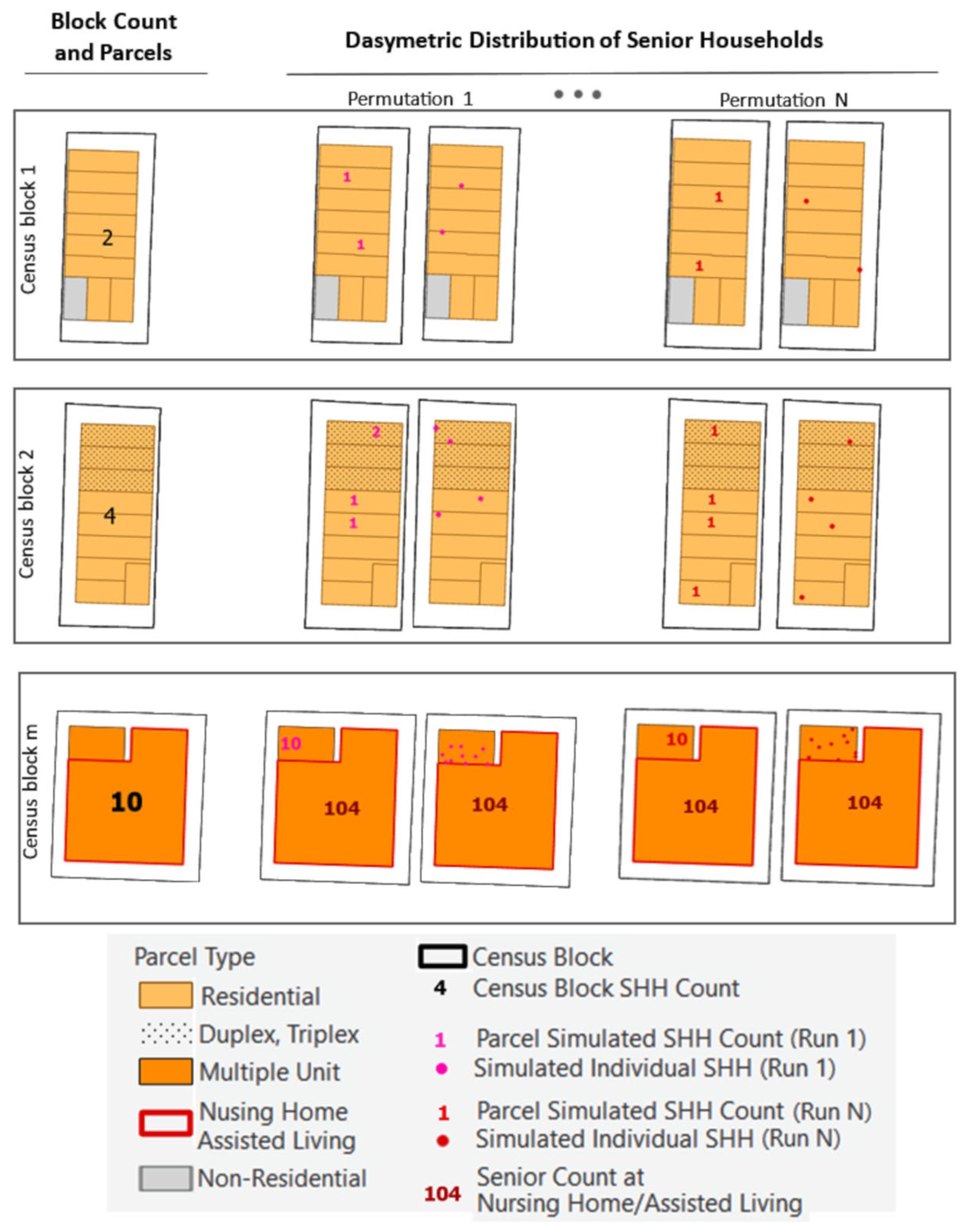
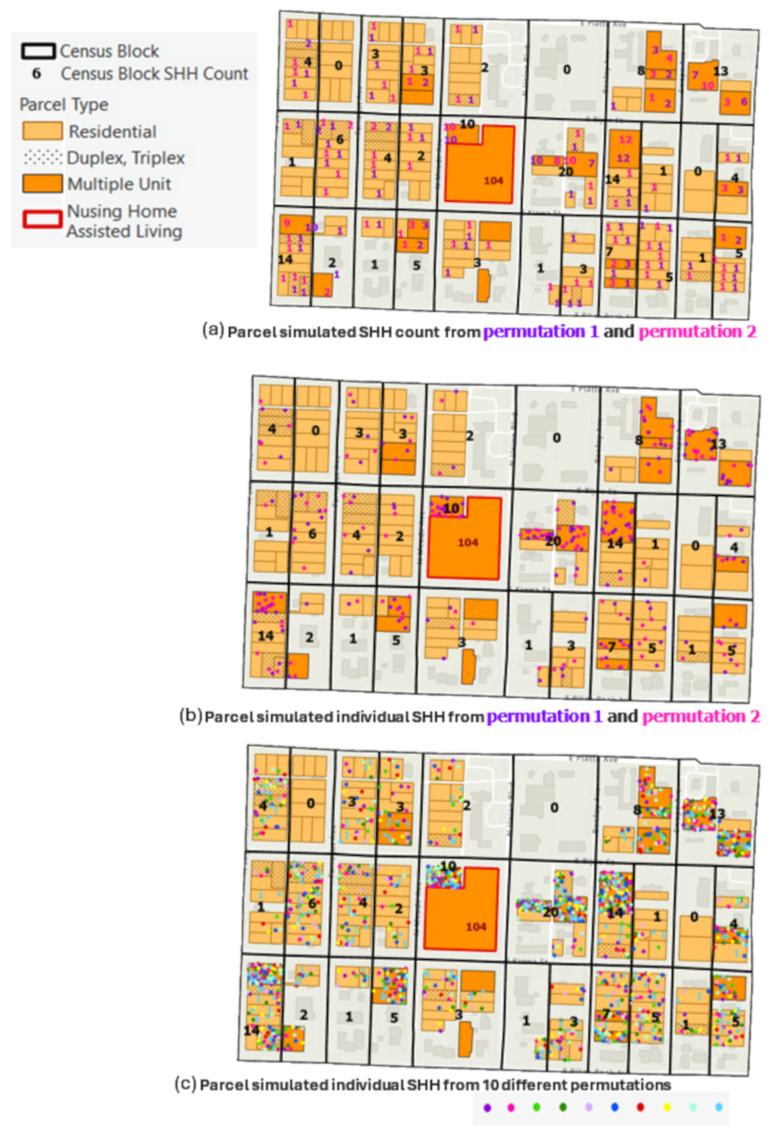
- Fine-scale senior population disaggregation via dasymetric modeling. We downscale senior household counts from census blocks to residential housing units. Dasymetric modeling replaces uniform areal assumptions with actual residential housing allocation, producing synthetic senior household microdata suitable for parcel and housing-unit-level analytics.
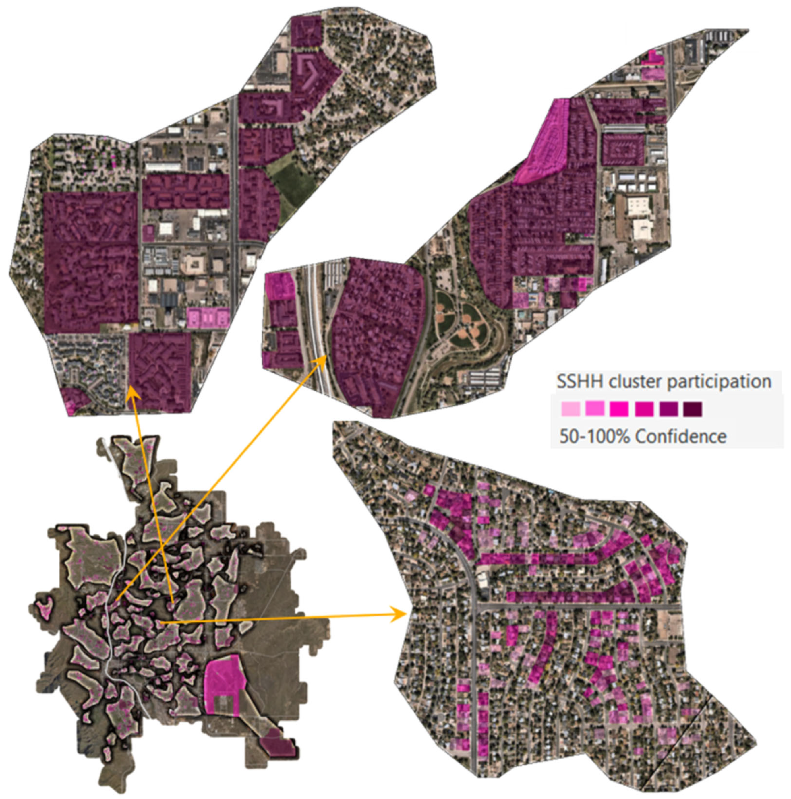
- Robust spatial clustering with stability confidence measures. We detect concentration patterns using noise-resistant clustering with parameter optimization and evaluate their stability across simulation runs. This process yields both cluster-level footprint stability measures and parcel-level participation confidence measures of membership stability across simulations, transforming detected concentrations into inference-ready parcel groups rather than heuristic visuals.
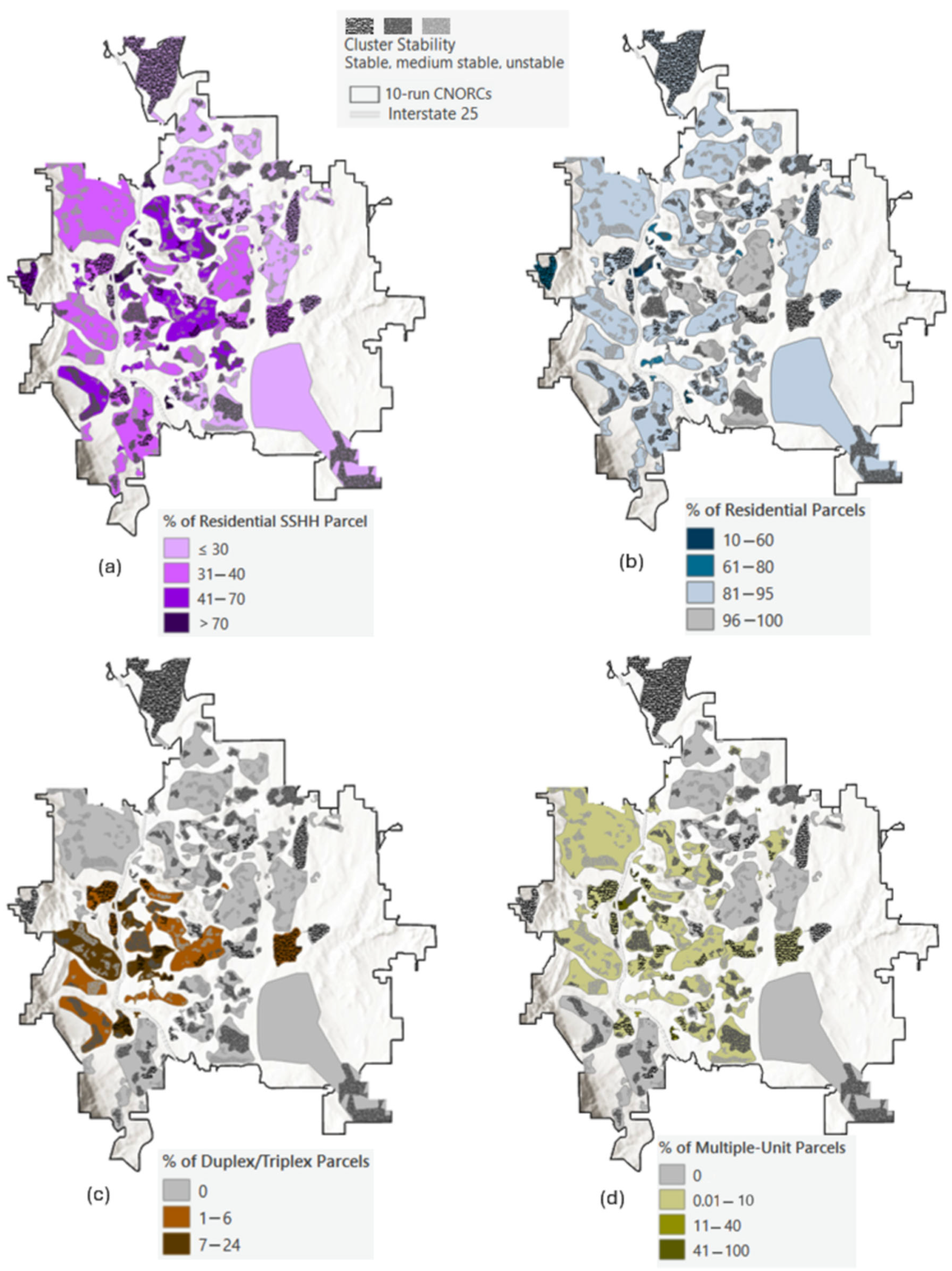
- NORC characterization across forms and scales. We profile detected clusters with structural indicators (e.g., share of residential parcels, proportion of senior households, prevalence of multi-unit buildings) to distinguish horizontal NORCs (neighborhood-scale, low-rise fabric) from vertical NORCs (building-scale, multi-unit structures). This typology links detected geospatial patterns to actionable planning contexts.
2. Background and Methodological Context
2.1. Definition and Characteristics of NORCs
2.2. Prior Geospatial Foundations
2.2.1. Fine-Scale Population Modeling of the Residential Fabric
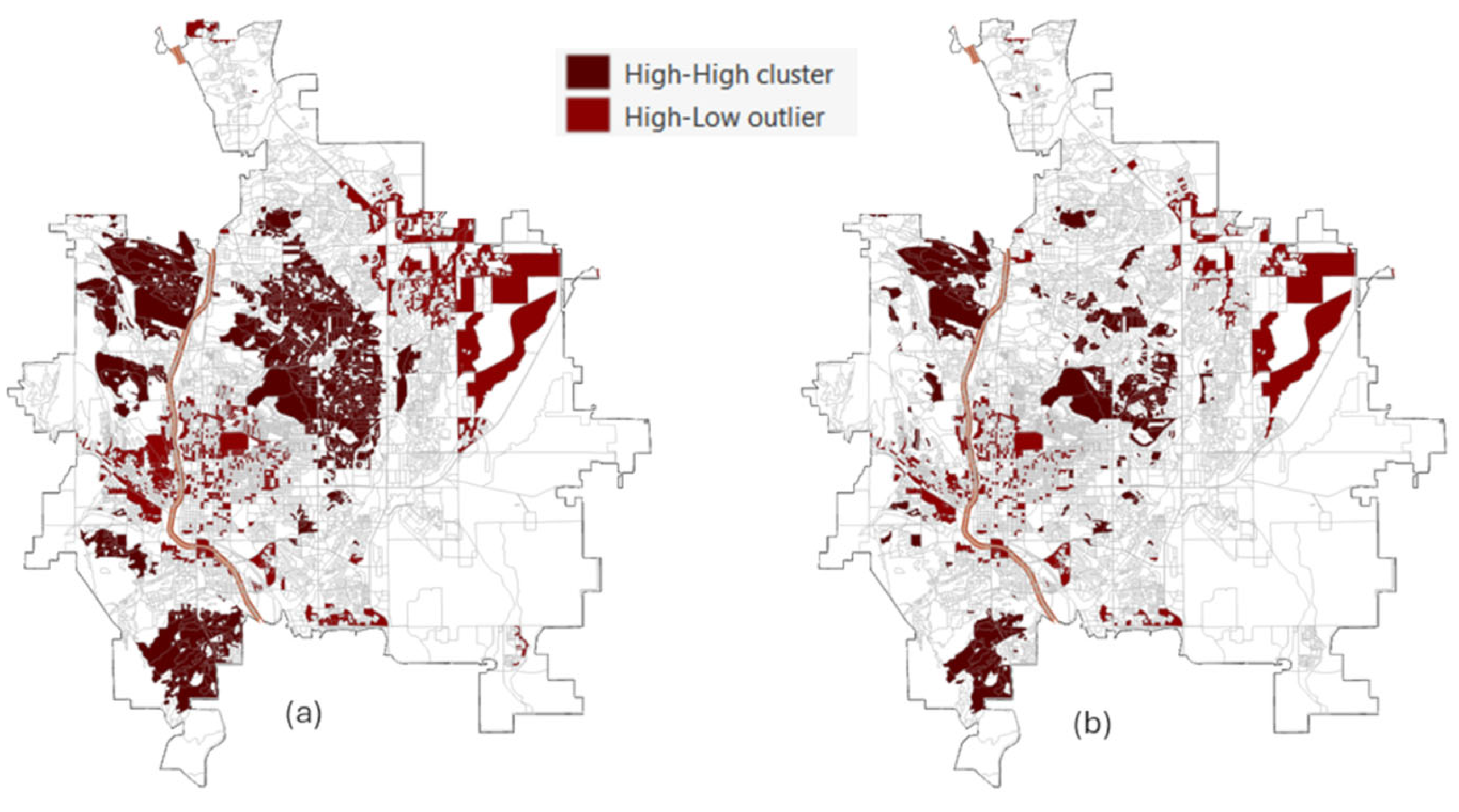
2.2.2. Existing Areal-Based Cluster Inference and Its Pitfalls
2.3. Our Contribution: NORC-SIMCLUST
3. Methodology
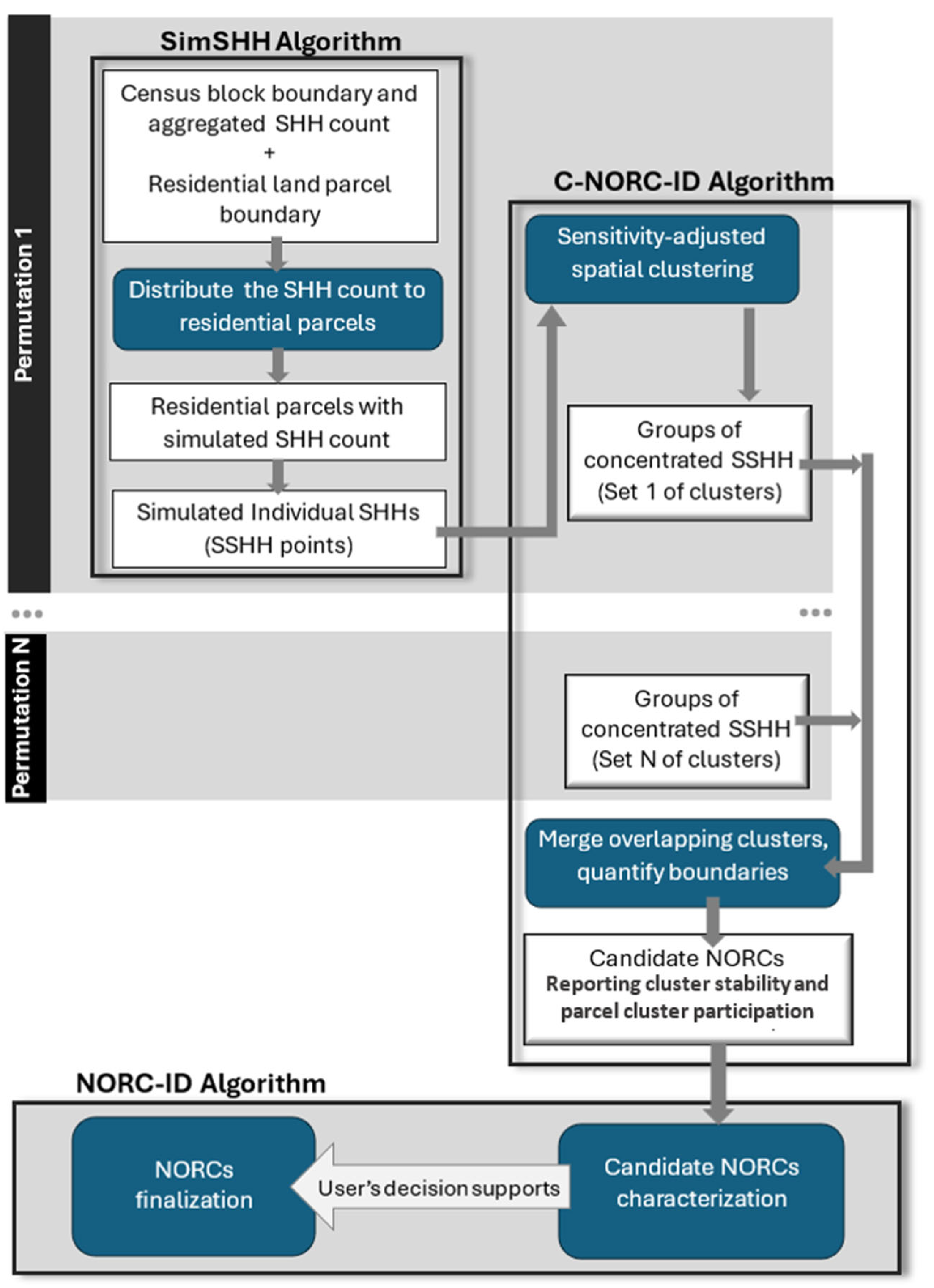
- SimSHH simulates senior household (SHH) data at the parcel level and incorporates permutations to generate multiple synthetic datasets.
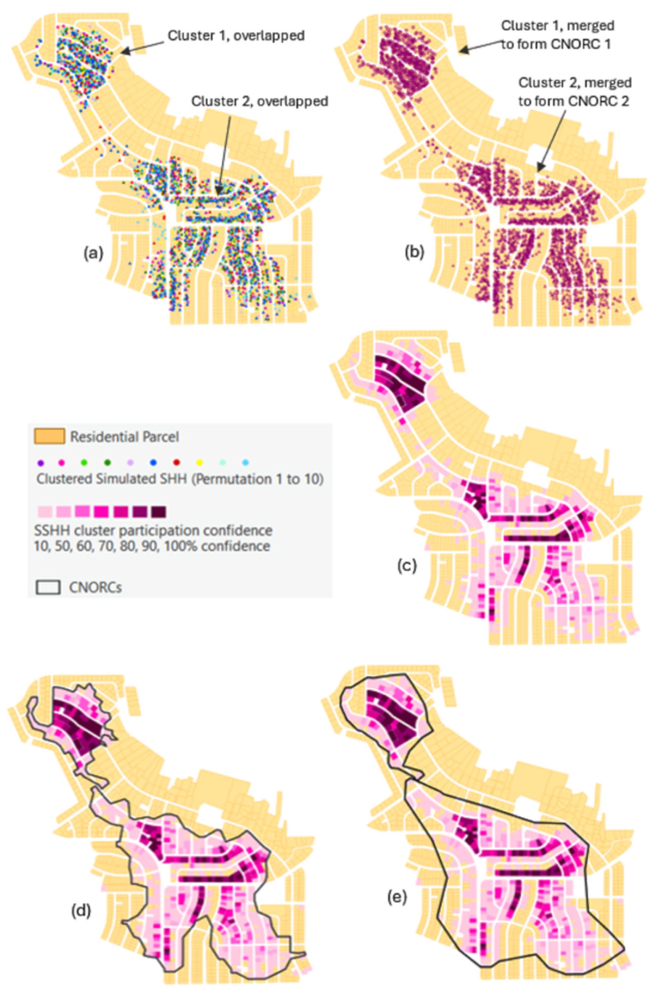
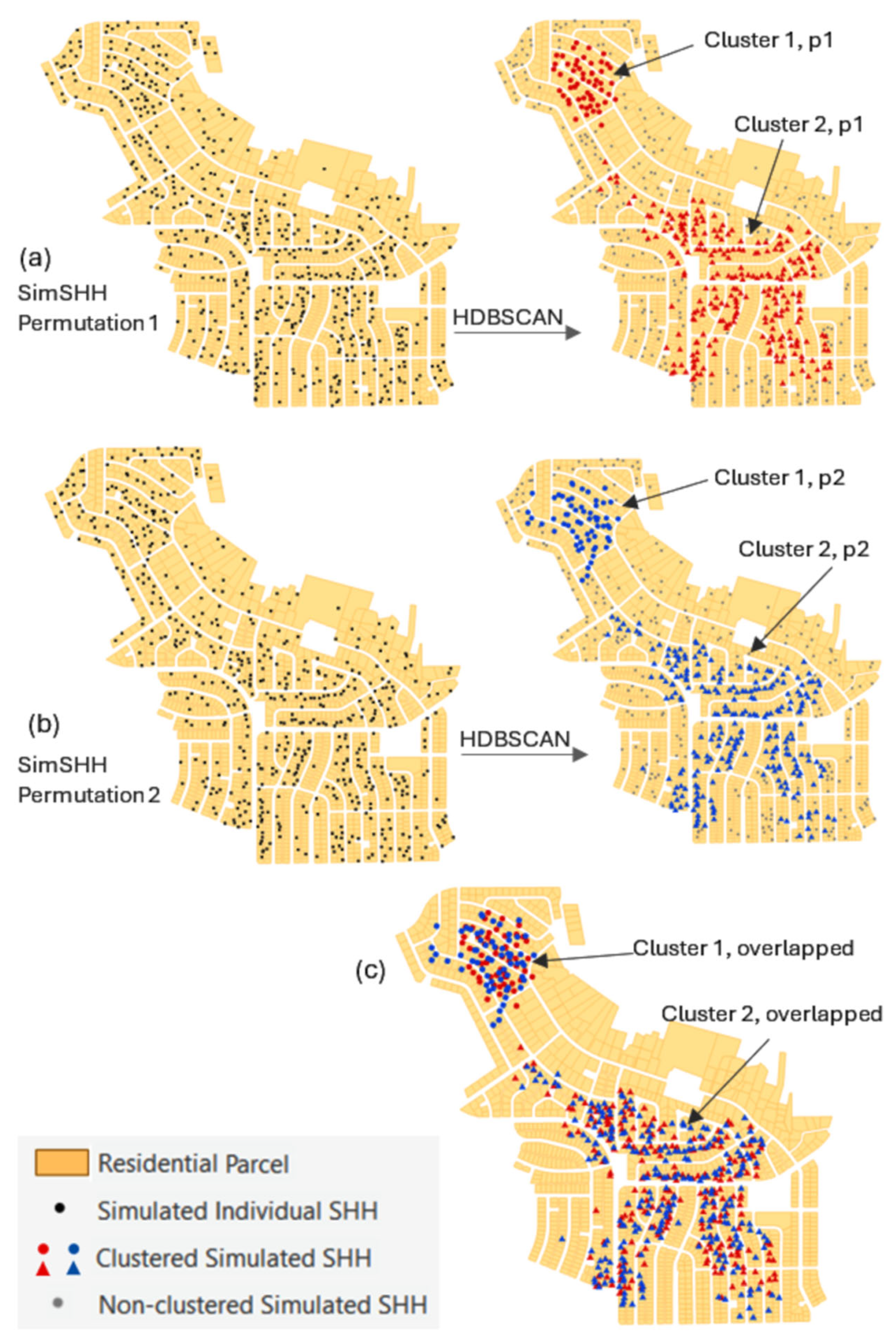
- C-NORC-ID applies noise resistant, density based spatial clustering with parameter sensitivity assessment to detect SHH concentrations for each simulated dataset. Overlapping clusters are merged to form NORC candidates (C-NORCs), with quantified boundaries, cluster footprint stability, and parcel participation confidence.
- NORC-ID evaluates NORC candidates based on housing composition and supports final NORC selection using specified characteristics and confidence thresholds.
3.1. The SimSHH Algorithm
3.2. The C-NORC-ID Algorithm
3.2.1. Parameter-Optimized Clustering with HDBSCAN
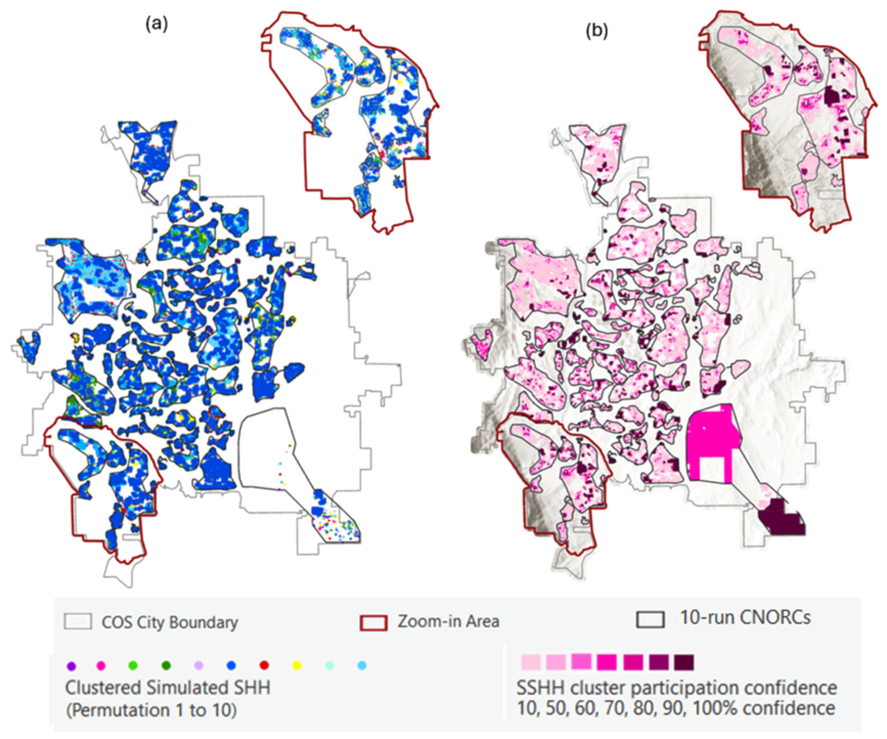
3.2.2. C-NORCs: Boundary and Confidence Measure
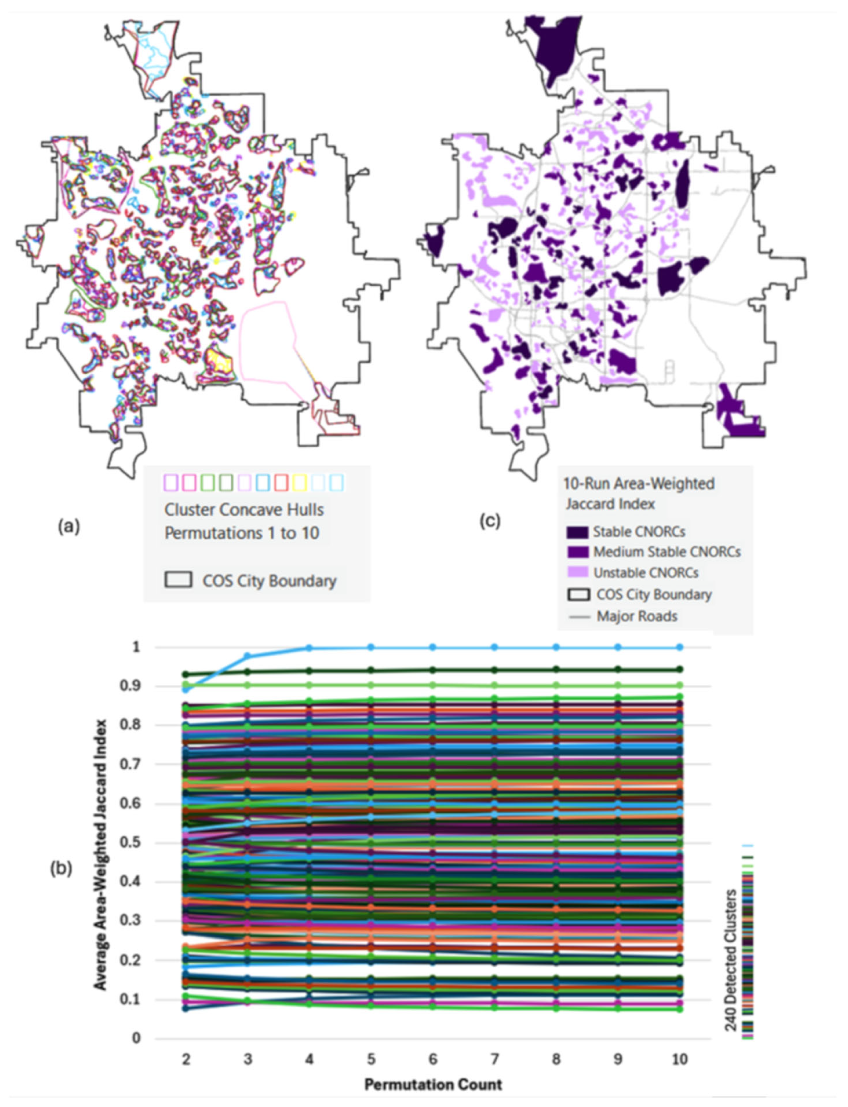
3.2.3. Cluster Stability Assessment Across Simulation Runs
3.2.4. Cluster Stability Convergence as Evidence of Robust Spatial Structure to Identify C-NORCs
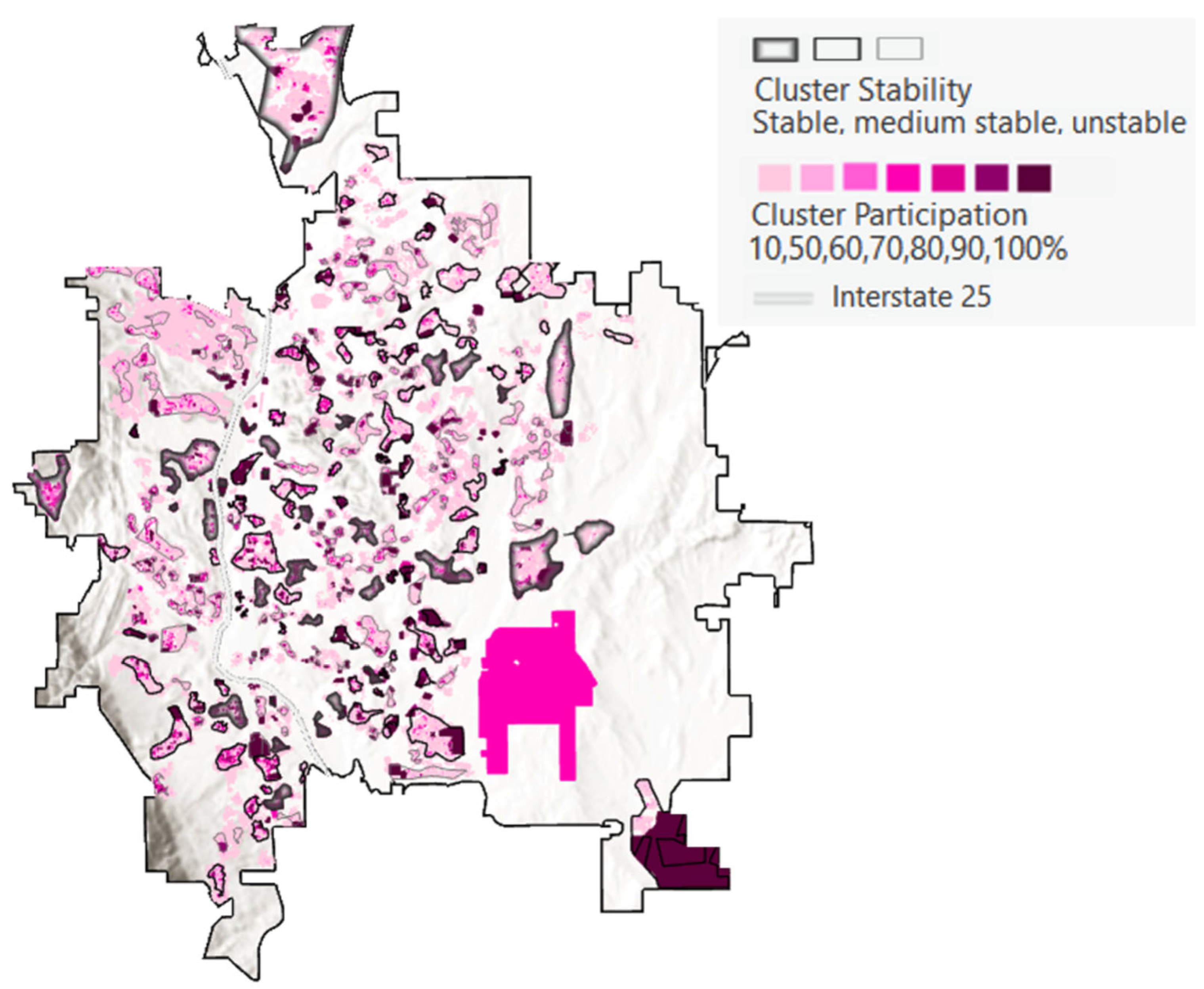
3.2.5. Distinguish Between Cluster Footprint Stability and Internal Parcel-Level Stability Under Within-Block Uncertainty
3.3. NORC-ID Algorithm
3.4. The NORC-SIMCLUST Workflow
4. Application: Identify NORCs in Colorado Springs, Colorado, USA
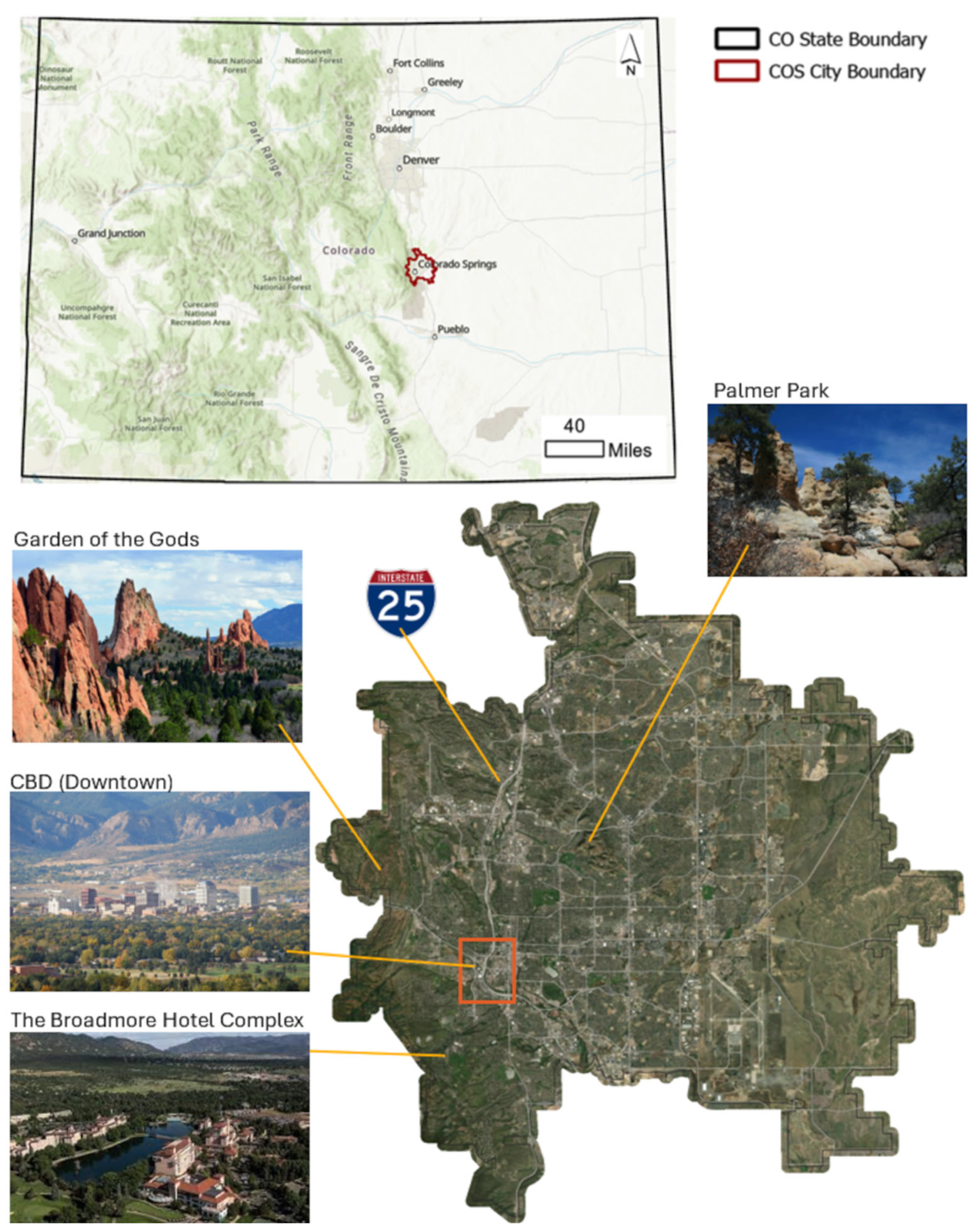
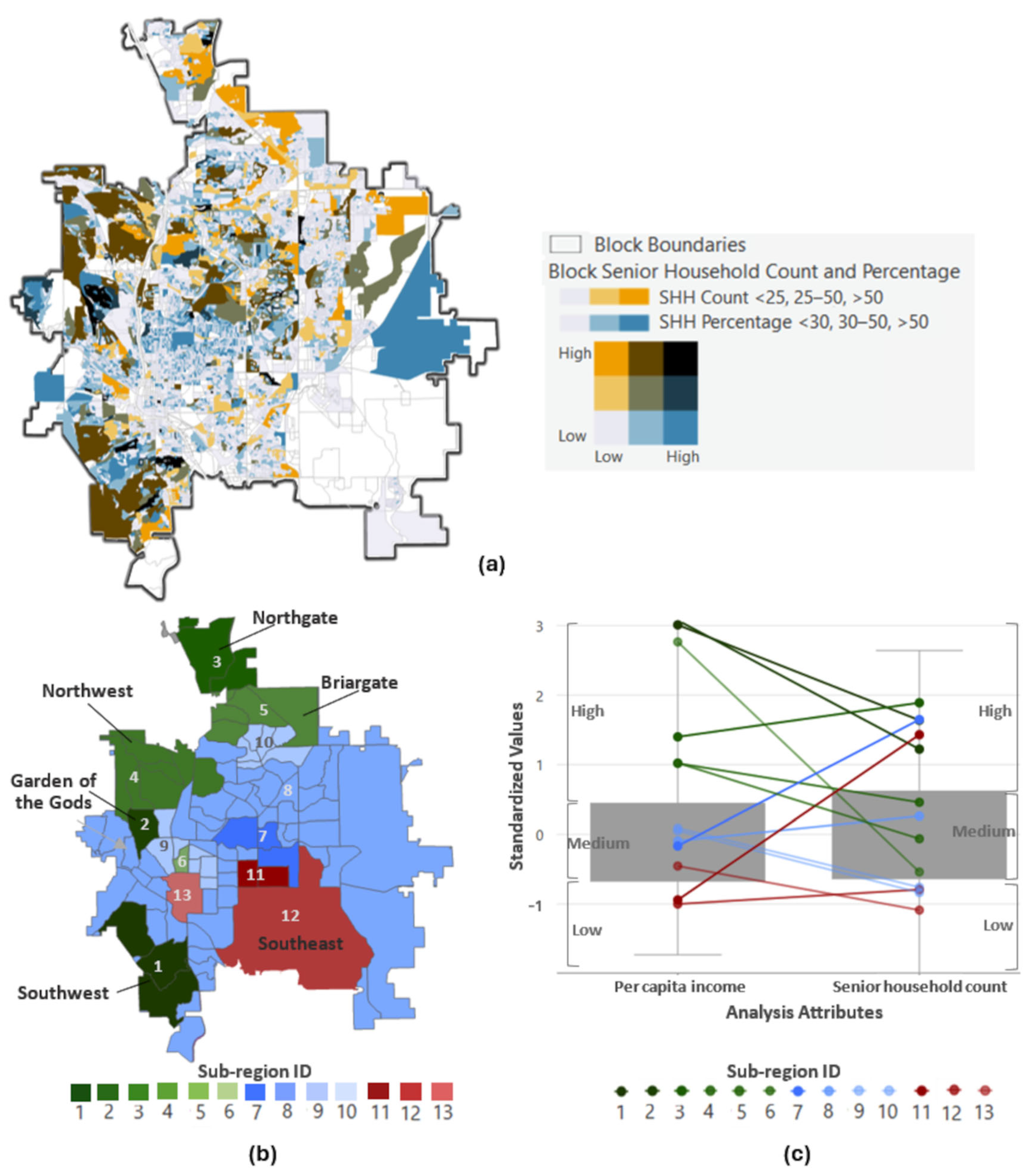
4.1. Colorado Springs: Landscapes and Seniors
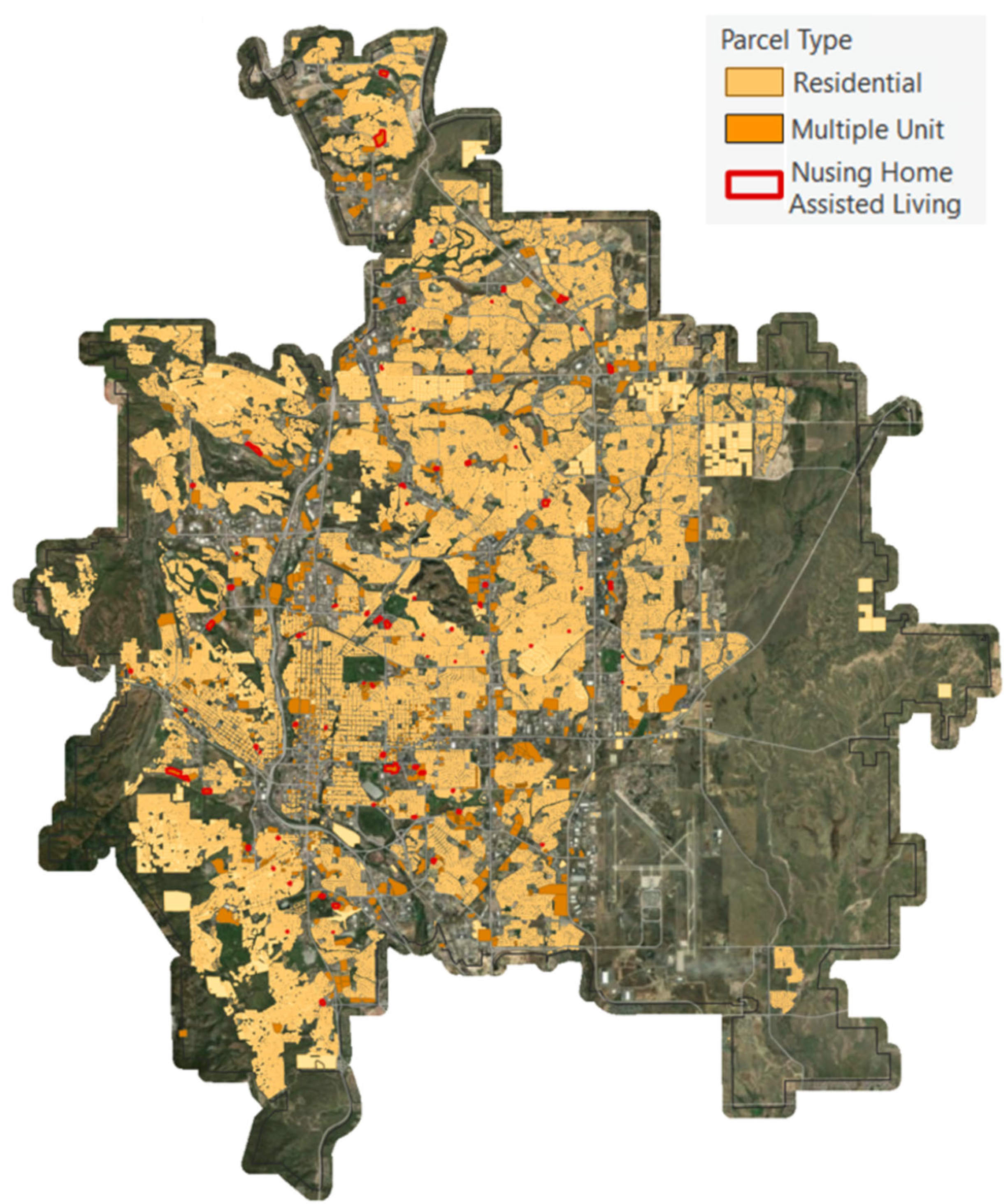
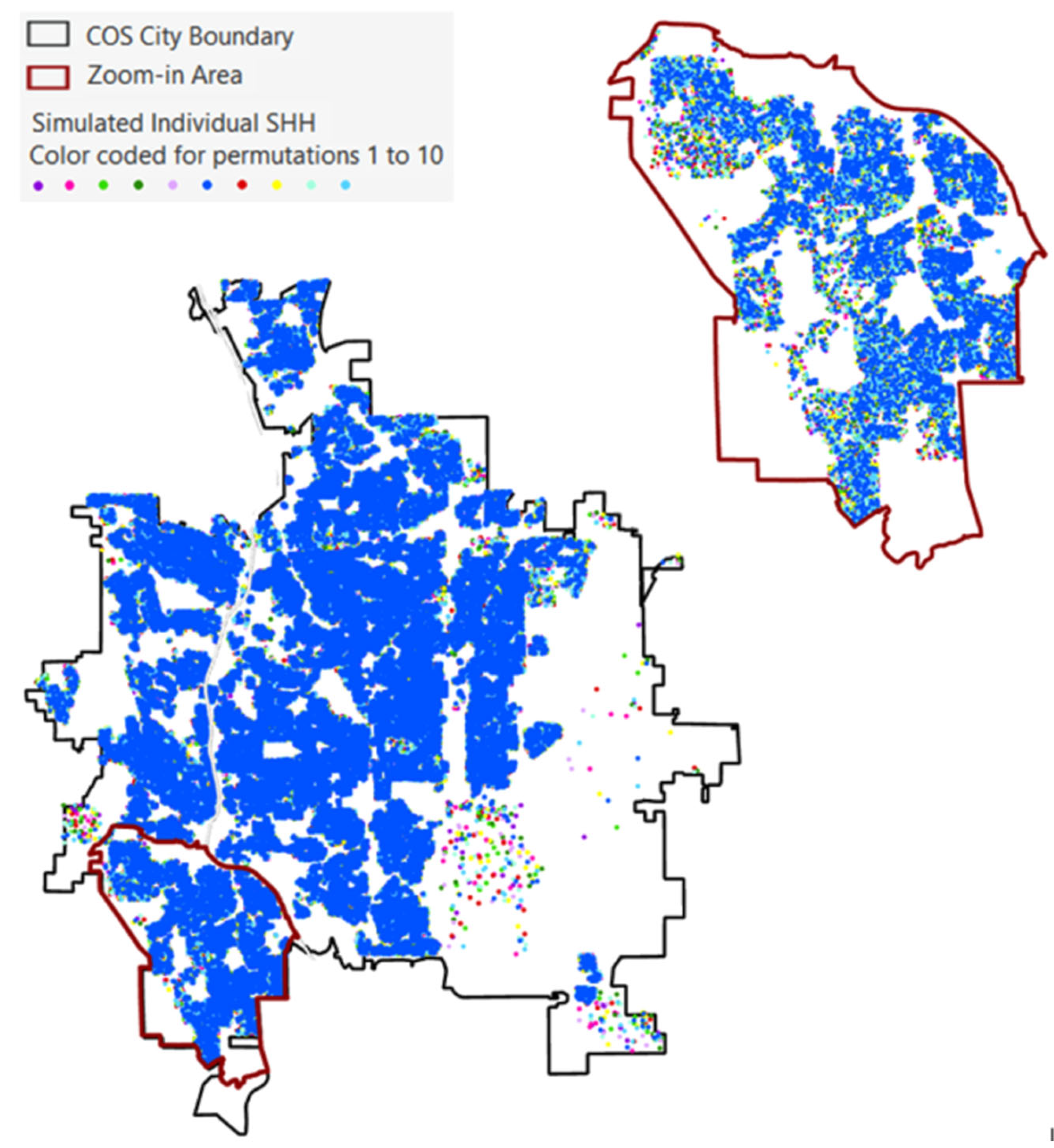
4.2. SimSHH Algorithm and Simulated Senior Household Result
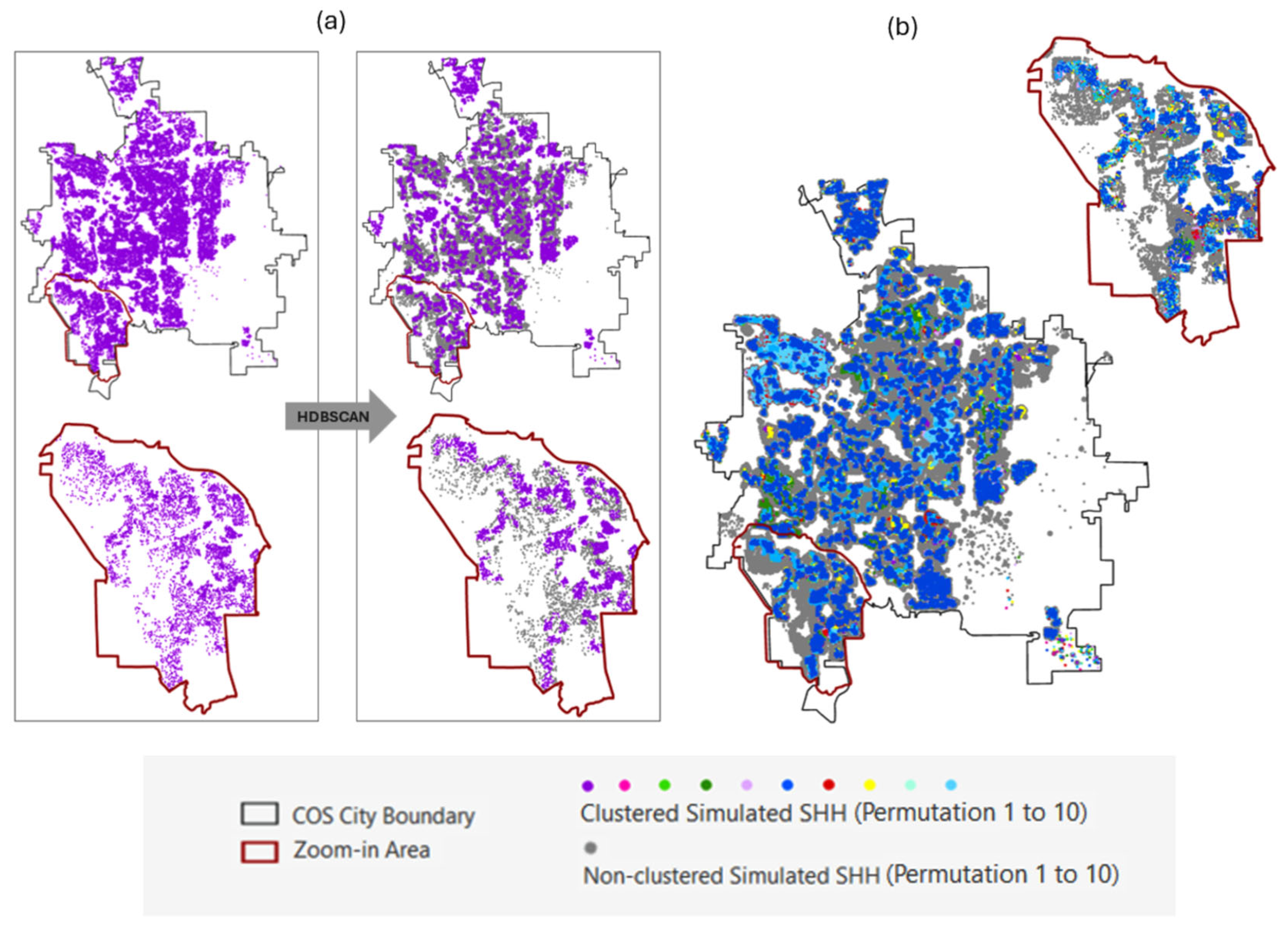
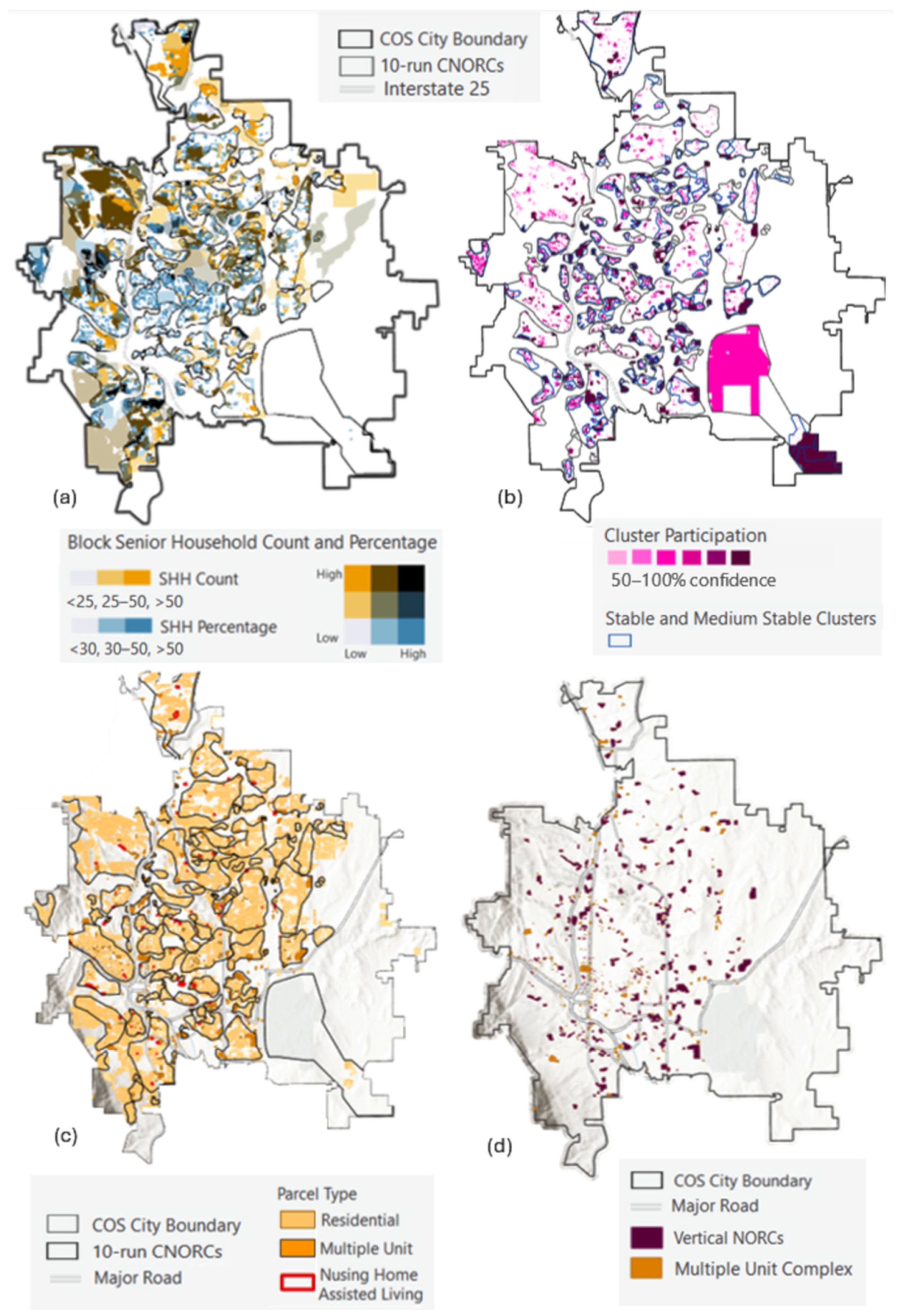
4.3. C-NORC-ID Process and Result
4.3.1. Clustering Parameter Sensitivity Analysis Result
4.3.2. Cluster Stability Assessment Result
4.3.3. Merging Clusters to Form C-NORCs
4.4. NORC-ID Process and Result
5. Conclusions
Supplementary Materials
Author Contributions
Funding
Institutional Review Board Statement
Informed Consent Statement
Data Availability Statement
Conflicts of Interest
Abbreviations
| C-NORC | Candidate Natural Occurring Retirement Community |
| DBSCAN | Density-Based Spatial Clustering of Applications with Noise |
| HDBSCAN | Hierarchical Density-Based Spatial Clustering of Applications with Noise |
| GIS | Geographical Information Science |
| NORC | Natural Occurring Retirement Community |
| NORC-SSP | Natural Occurring Retirement Community—Support Service Program |
| SHH | Senior Household |
References
- United Nations Department of Economic and Social Affairs (UNDESA). Our World Is Growing Older: UN DESA Releases New Report on Ageing; UN DESA: New York, NY, USA, 2019; Available online: https://www.un.org/development/desa/en/news/population/our-world-is-growing-older.html (accessed on 18 December 2025).
- E, J.; Xia, B.; Susilawati, C.; Chen, Q.; Wang, X. An Overview of Naturally Occurring Retirement Communities (NORCs) for Ageing in Place. Buildings 2022, 12, 519. [Google Scholar] [CrossRef] [Scilit]
- Parniak, S.; DePaul, V.G.; Frymire, C.; DePaul, S.; Donnelly, C. Naturally Occurring Retirement Communities: Scoping Review. JMIR Aging 2022, 5, e34577. [Google Scholar] [CrossRef] [Scilit]
- Hunt, M.E.; Gunter-Hunt, G. Naturally Occurring Retirement Communities. J. Hous. Elder. 1986, 3, 3–22. [Google Scholar] [CrossRef] [Scilit]
- Kloseck, M.; Crilly, R.G.; Gutman, G. Naturally Occurring Retirement Communities: Untapped Resources to Enable Optimal Aging at Home. J. Hous. Elder. 2010, 24, 392–412. [Google Scholar] [CrossRef] [Scilit]
- Bedney, B.J.; Goldberg, R.B.; Josephson, K. Aging in Place in Naturally Occurring Retirement Communities: Transforming Aging Through Supportive Service Programs. J. Hous. Elder. 2010, 24, 304–321. [Google Scholar] [CrossRef] [Scilit]
- Marshall, L.J.; Hunt, M. Rural Naturally Occurring Retirement Communities. J. Hous. Elder. 2008, 13, 19–34. [Google Scholar] [CrossRef] [Scilit]
- Vladeck, F.; Segel, R. Identifying Risks to Healthy Aging in New York City’s Varied NORCs. J. Hous. Elder. 2010, 24, 356–372. [Google Scholar] [CrossRef] [Scilit]
- Aurand, A.; Miles, R.; Usher, K. Local Environment of Neighborhood Naturally Occurring Retirement Communities (NORCs) in a Mid-Sized U.S. City. J. Hous. Elder. 2014, 28, 133–164. [Google Scholar] [CrossRef] [Scilit]
- Hunt, M.E.; Marshall, L.J.; Merrill, J.L. Rural Areas That Affect Older Migrants. J. Archit. Plan. Res. 2002, 19, 44–56. [Google Scholar]
- Anetzberger, G.J. Community Options of Greater Cleveland, Ohio: Preliminary Evaluation of a Naturally Occurring Retirement Community Program. Clin. Gerontol. 2009, 33, 1–15. [Google Scholar] [CrossRef] [Scilit]
- Rivera-Hernandez, M.; Yamashita, T.; Kinney, J.M. Identifying Naturally Occurring Retirement Communities: A Spatial Analysis. J. Gerontol. B Psychol. Sci. Soc. Sci. 2015, 70, 619–627. [Google Scholar] [CrossRef] [Scilit]
- E, J.; Xia, B.; Buys, L.; Yigitcanlar, T. Sustainable Urban Development for Older Australians: Understanding the Formation of Naturally Occurring Retirement Communities in the Greater Brisbane Region. Sustainability 2021, 13, 9853. [Google Scholar] [CrossRef] [Scilit]
- DePaul, V.G.; Parniak, S.; Frymire, C.; DePaul, S.A.; Donnelly, C.A. Identification and Engagement of Naturally Occurring Retirement Communities to Support Healthy Aging in Canada: A Set of Methods for Replication. JMIR Aging 2022, 5, e37617. [Google Scholar] [CrossRef] [Scilit] [PubMed]
- Peng, Z.; Wang, R.; Liu, L.; Wu, H. Fine-Scale Dasymetric Population Mapping with Mobile Phone and Building Use Data Based on Grid Voronoi Method. ISPRS Int. J. Geo-Inf. 2020, 9, 344. [Google Scholar] [CrossRef] [Scilit]
- Bonnevie, I.M.; Hansen, H.S.; Schrøder, L. Dasymetric Algorithms Using Land Cover to Estimate Human Population at Smaller Spatial Scales. ISPRS Int. J. Geo-Inf. 2024, 13, 427. [Google Scholar] [CrossRef] [Scilit]
- Zhao, Y.; Zhang, Y.; Wang, H.; Du, X.; Li, Q.; Zhu, J. Intraday Variation Mapping of Population Age Structure via Urban-Functional-Region-Based Scaling. Remote Sens. 2021, 13, 805. [Google Scholar] [CrossRef] [Scilit]
- Friedman, S.; Fang, C.; Yang, T.-C.; Li, R.; Mithu, I.H.; Manganello, J.A.; Romeiko, X.; Lin, S. Mapping the Vulnerability of Older-Adult Neighborhoods: An Ecological Study of New York State. Int. J. Environ. Res. Public Health 2025, 22, 332. [Google Scholar] [CrossRef] [Scilit]
- Cartagena-Colón, M.; Mattei, H.; Wang, C. Dasymetric Mapping of Population Using Land Cover Data in JBNERR, Puerto Rico during 1990–2010. Land 2022, 11, 2301. [Google Scholar] [CrossRef] [Scilit]
- Rebelo, C.; Rodrigues, A.M.; Tenedório, J.A. Dasymetric Mapping Using UAV High Resolution 3D Data within Urban Areas. Remote Sens. 2019, 11, 1716. [Google Scholar] [CrossRef] [Scilit]
- Aquilino, M.; Adamo, M.; Blonda, P.; Barbanente, A.; Tarantino, C. Improvement of a Dasymetric Method for Implementing Sustainable Development Goal 11 Indicators at an Intra-Urban Scale. Remote Sens. 2021, 13, 2835. [Google Scholar] [CrossRef] [Scilit]
- Bronstein, L.; Kenaley, B.L.D. Learning from Vertical NORCs: Challenges and Recommendations for Horizontal NORCs. J. Hous. Elder. 2010, 24, 237–248. [Google Scholar] [CrossRef] [Scilit]
- Dao, T.H.D.; Dao, K.A.; Barboza-Salerno, G. Uncovering Spatial Patterns of Residential Settlements, Segregation, and Vulnerability of Urban Seniors Using Geospatial Analytics and Modeling Techniques. Urban Sci. 2024, 8, 81. [Google Scholar] [CrossRef] [Scilit]
- Anselin, L. Local Indicators of Spatial Association—LISA. Geogr. Anal. 1995, 27, 93–115. [Google Scholar] [CrossRef] [Scilit]
- Getis, A.; Ord, J.K. The Analysis of Spatial Association by Use of Distance Statistics. Geogr. Anal. 1992, 24, 189–206. [Google Scholar] [CrossRef] [Scilit]
- Morrison, P.A.; Bryan, T.M. Targeting Spatial Clusters of Elderly Consumers in the U.S.A. Popul. Res. Policy Rev. 2010, 29, 33–46. [Google Scholar] [CrossRef] [Scilit]
- Li, F.; Zhou, J.; Wei, W.; Yin, L. Spatial Distribution Pattern and Evolution Characteristics of Elderly Population in Wuhan Based on Census Data. Land 2023, 12, 1350. [Google Scholar] [CrossRef] [Scilit]
- Lu, B.; Dong, Z.; Yue, P.; Qin, K. Spatial Analysis of the Aging Population and Socio-economic Factors of China: Global and Local Perspectives. J. Geod. Geoinf. Sci. 2024, 7, 37–51. [Google Scholar] [CrossRef]
- Eicher, C.L.; Brewer, C.A. Dasymetric Mapping and Areal Interpolation: Implementation and Evaluation. Cartogr. Geogr. Inf. Sci. 2001, 28, 125–138. [Google Scholar] [CrossRef] [Scilit]
- Sleeter, R.; Gould, M. Geographic Information System Software to Remodel Population Data Using Dasymetric Mapping Methods; U.S. Geological Survey—Techniques and Methods 11-C2; U.S. Geological Survey: Reston, VA, USA, 2007; 15p. [CrossRef] [Scilit]
- Openshaw, S. The Modifiable Area Unit Problem; Concepts and Techniques in Modern Geography; Geo Books: Norwich, UK, 1984; Volume 38. [Google Scholar]
- Wong, D.W.S. The Modifiable Areal Unit Problem (MAUP). In WorldMinds: Geographical Perspectives on 100 Problems; Janelle, D.G., Warf, B., Hansen, K., Eds.; Springer: Dordrecht, The Netherlands, 2004; pp. 571–575. [Google Scholar] [CrossRef] [Scilit]
- Manley, D. Scale, Aggregation, and the Modifiable Areal Unit Problem. In Handbook of Regional Science, Living Reference Entry; Fischer, M.M., Nijkamp, P., Eds.; Springer: Berlin/Heidelberg, Germany, 2019; pp. 1–15. [Google Scholar] [CrossRef] [Scilit]
- Campello, R.J.G.B.; Moulavi, D.; Sander, J. Density-Based Clustering Based on Hierarchical Density Estimates. In Advances in Knowledge Discovery and Data Mining: 17th Pacific-Asia Conference, PAKDD 2013; Springer: Berlin/Heidelberg, Germany, 2013; pp. 160–172. [Google Scholar] [CrossRef] [Scilit]
- Campello, R.J.G.B.; Moulavi, D.; Zimek, A.; Sander, J. Hierarchical Density Estimates for Data Clustering, Visualization, and Outlier Detection. ACM Trans. Knowl. Discov. Data 2015, 10, 1–51. [Google Scholar] [CrossRef] [Scilit]
- McInnes, L.; Healy, J.; Astels, S. HDBSCAN: Hierarchical Density Based Clustering. J. Open Source Softw. 2017, 2, 205. [Google Scholar] [CrossRef] [Scilit]
- O’Sullivan, D.; Unwin, D.J. Geographic Information Analysis, 2nd ed.; John Wiley & Sons: Hoboken, NJ, USA, 2010. [Google Scholar]
- Rousseeuw, P.J. Silhouettes: A Graphical Aid to the Interpretation and Validation of Cluster Analysis. J. Comput. Appl. Math. 1987, 20, 53–65. [Google Scholar] [CrossRef] [Scilit]
- Moulavi, D.; Jaskowiak, P.A.; Campello, R.J.G.B.; Zimek, A.; Sander, J. Density-Based Clustering Validation. In Proceedings of the 2014 SIAM International Conference on Data Mining (SDM); SIAM: Philadelphia, PA, USA, 2014; pp. 839–847. [Google Scholar] [CrossRef] [Scilit]
- Arthur, D.; Vassilvitskii, S. K-means++: The Advantages of Careful Seeding. In Proceedings of the Eighteenth Annual ACM-SIAM Symposium on Discrete Algorithms (SODA ’07); Society for Industrial and Applied Mathematics: Philadelphia, PA, USA, 2007; pp. 1027–1035. [Google Scholar]
- Edelsbrunner, H.; Kirkpatrick, D.; Seidel, R. On the shape of a set of points in the plane. IEEE Trans. Inf. Theory 1983, 29, 551–559. [Google Scholar] [CrossRef] [Scilit]
- Asaeedi, S.; Didehvar, F.; Mohades, A. α-Concave hull, a generalization of convex hull. Theor. Comput. Sci. 2017, 702, 48–59. [Google Scholar] [CrossRef] [Scilit]
- Levy, A.; Shalom, B.R.; Chalamish, M. A guide to similarity measures and their data science applications. J. Big Data 2025, 12, 188. [Google Scholar] [CrossRef] [Scilit]
- Tang, M.; Kaymaz, Y.; Logeman, B.L.; Eichhorn, S.W.; Liang, Z.S.; Dulac, C.; Sackton, T.B. Evaluating single-cell cluster stability using the Jaccard similarity index. Bioinformatics 2021, 37, 2212–2214. [Google Scholar] [CrossRef] [Scilit] [PubMed]
- U.S. News & World Report. Best Places to Live in the U.S. in 2023–2024. Available online: https://realestate.usnews.com/places/rankings/best-places-to-live (accessed on 22 April 2024).
- City of Colorado Springs. Comprehensive Plan and Land Use Data. Available online: https://coloradosprings.gov (accessed on 19 December 2025).
- Colorado Energy Office. Colorado Springs Land Use and Zoning Overview. Available online: https://energyoffice.colorado.gov (accessed on 19 December 2025).
- U.S. Department of Housing and Urban Development (HUD). Consolidated Plan for Colorado Springs. Available online: https://coloradosprings.gov/2025AnnualActionPlan (accessed on 19 December 2025).
- The United States Census Bureau. QuickFacts Colorado Springs City, Colorado. Available online: https://www.census.gov/quickfacts/fact/table/coloradospringscitycolorado/POP010220#POP010220 (accessed on 31 March 2024).
- Golant, S.M. The Quest for Residential Normalcy by Older Adults: Relocation But One Pathway. J. Aging Stud. 2011, 25, 193–205. [Google Scholar] [CrossRef] [Scilit]







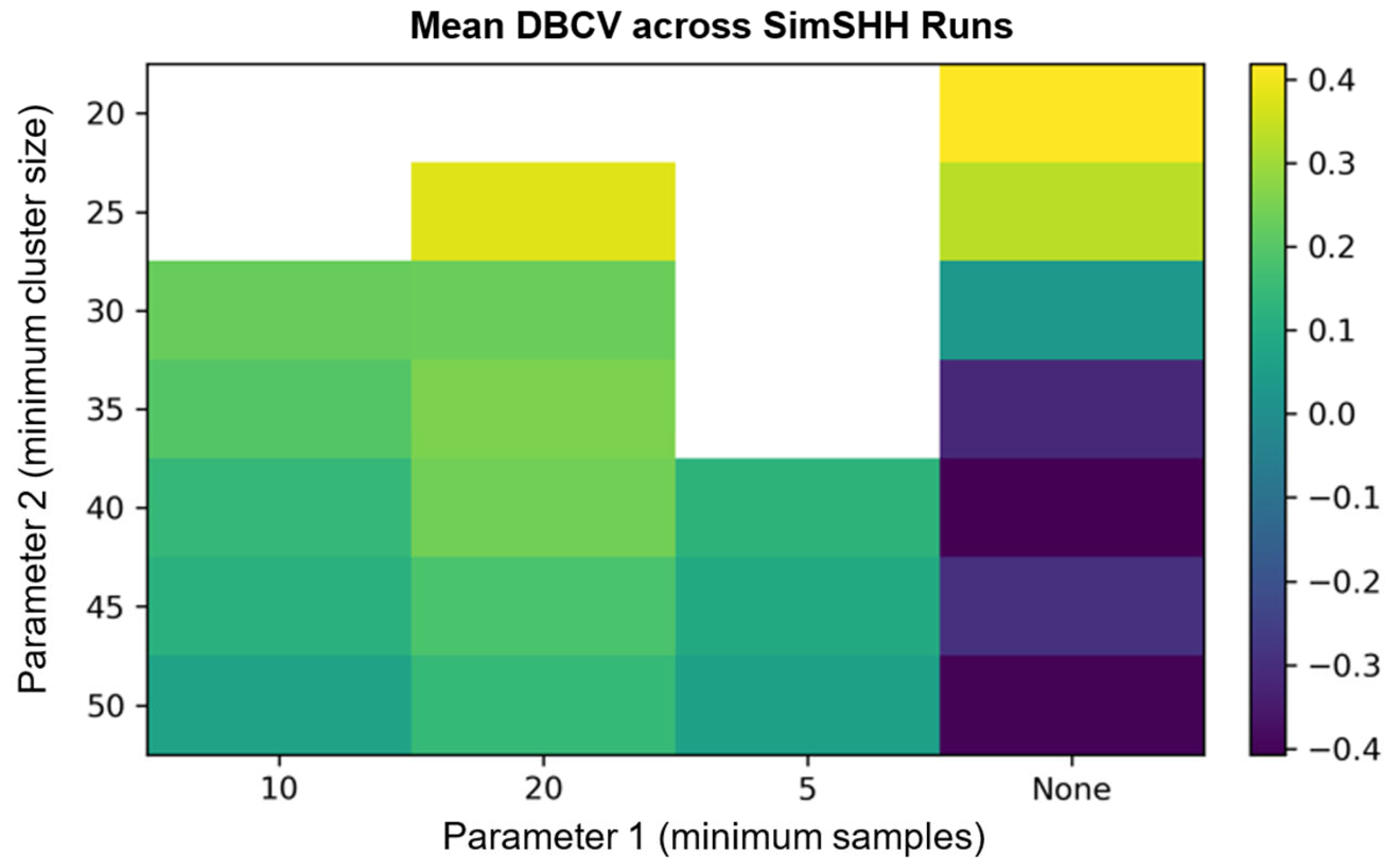
| Run ID | Parameter 1 (Minimum Cluster Size) | Parameter 2 (Minimum Samples) | DBCV | Noise Fraction | Cluster Count |
|---|---|---|---|---|---|
| 1 | 30 | None | 0.4 | 0.5 | 240 |
| 2 | 25 | 20 | 0.4 | 0.4 | 319 |
| 3 | 45 | None | 0.3 | 0.4 | 134 |
| 4 | 25 | None | 0.3 | 0.4 | 259 |
| 5 | 20 | None | 0.4 | 0.4 | 367 |
| 6 | 35 | 20 | 0.4 | 0.4 | 257 |
| 7 | 35 | None | 0.3 | 0.4 | 179 |
| 8 | 30 | None | 0.3 | 0.4 | 223 |
| 9 | 25 | 20 | 0.4 | 0.4 | 312 |
| 10 | 30 | None | 0.3 | 0.4 | 212 |
Disclaimer/Publisher’s Note: The statements, opinions and data contained in all publications are solely those of the individual author(s) and contributor(s) and not of MDPI and/or the editor(s). MDPI and/or the editor(s) disclaim responsibility for any injury to people or property resulting from any ideas, methods, instructions or products referred to in the content. |
© 2026 by the authors. Published by MDPI on behalf of the International Society for Photogrammetry and Remote Sensing. Licensee MDPI, Basel, Switzerland. This article is an open access article distributed under the terms and conditions of the Creative Commons Attribution (CC BY) license.
Share and Cite
Dao, K.A.; Dao, T.H.D. Geospatial Dasymetric Modeling and Cluster Analysis with Stability Confidence Measures for Identifying Parcel-Level Naturally Occurring Retirement Communities. ISPRS Int. J. Geo-Inf. 2026, 15, 149. https://doi.org/10.3390/ijgi15040149
Dao KA, Dao THD. Geospatial Dasymetric Modeling and Cluster Analysis with Stability Confidence Measures for Identifying Parcel-Level Naturally Occurring Retirement Communities. ISPRS International Journal of Geo-Information. 2026; 15(4):149. https://doi.org/10.3390/ijgi15040149
Chicago/Turabian StyleDao, Khac An, and Thi Hong Diep Dao. 2026. "Geospatial Dasymetric Modeling and Cluster Analysis with Stability Confidence Measures for Identifying Parcel-Level Naturally Occurring Retirement Communities" ISPRS International Journal of Geo-Information 15, no. 4: 149. https://doi.org/10.3390/ijgi15040149
APA StyleDao, K. A., & Dao, T. H. D. (2026). Geospatial Dasymetric Modeling and Cluster Analysis with Stability Confidence Measures for Identifying Parcel-Level Naturally Occurring Retirement Communities. ISPRS International Journal of Geo-Information, 15(4), 149. https://doi.org/10.3390/ijgi15040149