1. Introduction
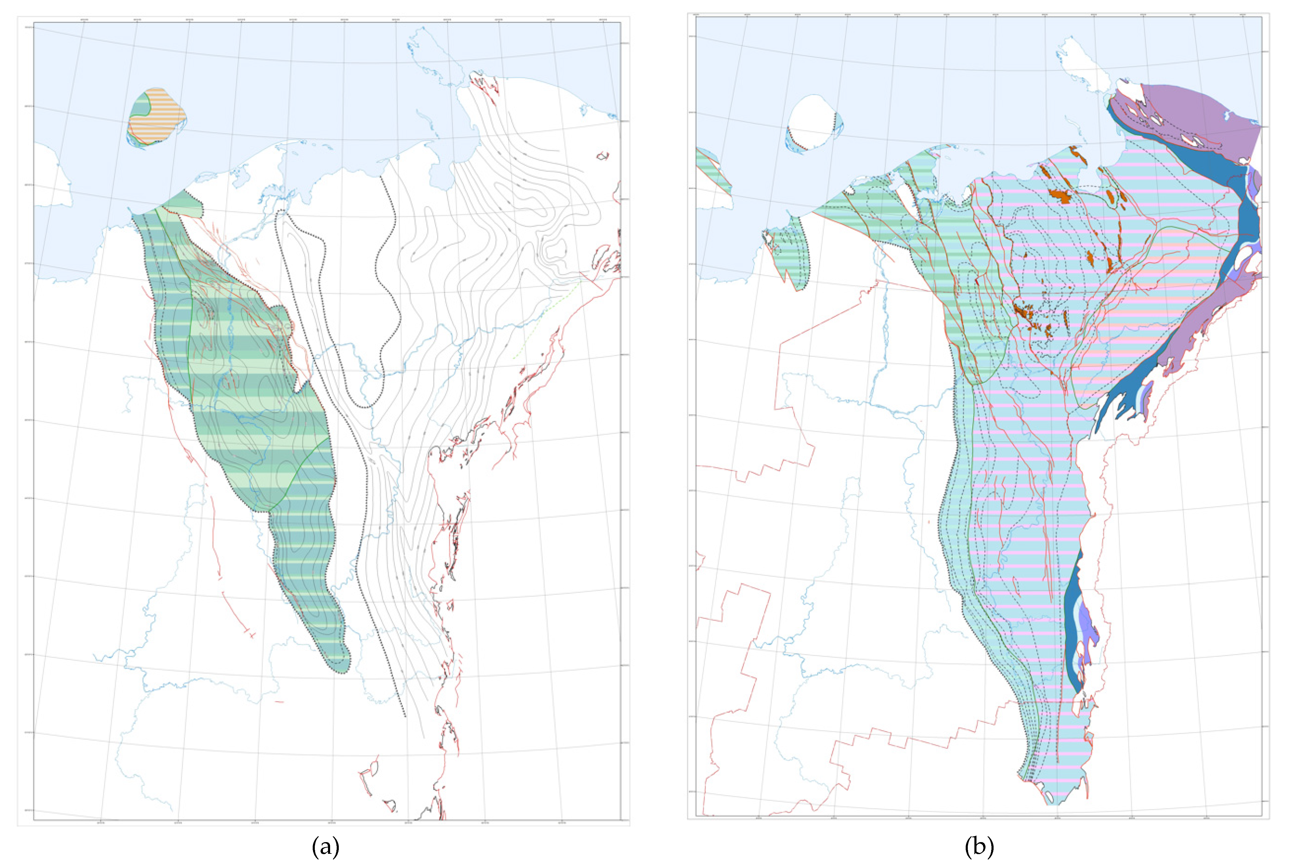
More than 5500 deep oil and gas wells with a drilling volume of 10 million meters have been drilled within the Timan–Pechora sedimentary basin (TP SB). Only 54 wells have been drilled in the water area of the sedimentary basin, most of which have only exposed Mesozoic deposits. Drilling within the limits of the land of the TP SB is also uneven. In the northern half of the Izhma–Pechora syneclise, which is the area of this study, it does not exceed 0.01 m/km
2 (
Figure 1), and it does not exceed 0.3 m/km
2 in the Malozemelsko–Kolguevskaya monocline, which indicates the lack of knowledge of this region and the prospects for the discovery of new oil and gas objects (
Figure 1).
In the Pechora–Kolva aulacogen, located in the east, it increases to 200 m/km
2 in some areas. The Khoreyver depression of the Khoreyversko–Pechoromorskaya syneclise is characterized by an average drilling depth of 50–100 m/km
2, but its coastal part has been studied to a much lesser extent—the drilling depth is only 10 m/km
2. In the water area on the eastern half of Kolguev Island (East Kolguev structural zone), the drilling density is close to 50 m/km
2. The most significant drilling operations on land were carried out by state-owned enterprises from the 1970s to the early 1990s of the last century [
2,
3].
A promising direction for further study of the region is the study of the storage reservoir and flow behavior in the Ordovician shale formation lying directly under the Silurian oil and gas source clay strata, which is a high-quality impermeable layer. Studies of the capacity of similar shale strata, from the point of view of the possibility of CO
2 storage capacity and flow behavior in the shale formation, have been carried out by the Journal of Petroleum Science and Technology 2022 [
4].
2. The Economic Significance of the Resource Development of the Hydrocarbon Potential of the Arctic Zone of the Russian Federation
The hydrocarbon (HC) potential of the Arctic zone of the Russian Federation (AZRF) is considered as a strategic reserve for the reproduction of the mineral resource base of oil and gas in the long term. A detailed geological study and the industrial development of the Arctic regions, especially the water areas, are associated with a number of problems related to natural and climatic features, the complex geological structure of deposits, technological features, and the imperfection of the regulatory framework—the current unfavorable economic situation in the global and domestic markets for fuel and energy resources [
5].
According to the results of the latest quantitative assessment, the volume of forecast resources of the Russian Arctic is estimated at more than 270 billion TOE (tonne of oil equivalent), including about 48.5 billion tons of oil and condensate and over 220 trillion m3 of natural gas. At the same time, land resources are estimated at 156 billion TOE (58% of the total volume), of which a significant part is accounted for by gas, while the share of the water areas accounts for 42% of all resources, mainly gas and gas condensate. The largest hydrocarbon potential of the land of the Arctic zone, if we consider the subjects of the Russian Federation, is estimated to be in the Yamalo–Nenets Autonomous District (120.5 billion TOE, including 98.8 trillion m3 of gas), followed by the Nenets Autonomous District (the northern part of the Timan–Pechora oil and gas province). In addition, with regards to the water area, the southern parts of the Kara and Barents Seas have the greatest potential, which are where all the deposits identified on the Arctic shelf and, accordingly, the oil, gas, and condensate reserves are located.
The raw hydrocarbon potential of the Arctic Seas of Russia is represented today by 19 deposits, most of which are located within the lips and bays of the Kara Sea; some are shelf extensions of onshore objects [
5,
6], and a smaller one is in the Pechora Sea on the continuation of the TPP. The volume of proven oil reserves is relatively small at 454 million tons, while the volume of projected oil resources is estimated at 12.8 billion tons, of which only 5% is concentrated in currently licensed areas. The volume of proven gas reserves is much larger at 9.2 trillion m
3, 70% of which comprises fields with valid licenses; the volume of the forecasted natural gas resource base is 86.5 trillion m
3 [
7,
8,
9].
The development of the HC raw material base of the AZRF, first of all, is associated with the implementation of large-scale projects for the exploration, production, and transportation of oil and gas on land, with the prospect of further using the created coastal industrial infrastructure in order to involve the marine hydrocarbon potential in industrial turnover and in the development of the Northern Sea Route. The coastal parts of the northern seas are now considered as outposts of testing and implementation of the latest technologies in the most difficult conditions [
8]. The Pechora Sea (the southern part of the Barents Sea) is considered as one of the most important bridgeheads for advancing into the Arctic water area on the basis of the already identified and predicted hydrocarbon potential [
10,
11,
12].
Since 2013, a project for the industrial development of the Prirazlomnoye oil field has been implemented in the Pechora Sea, the operator of which is PJSC “Gazprom Neft Shelf”. The project can be called successful in terms of being able to test a huge number of development technologies and logistics solutions in difficult ice conditions with the development of the interaction of various services and support vessels.
The Shtokman gas condensate field has been prepared for development in the Barents Sea, but the start of development was postponed due to technological difficulties, the need for huge investments, and economic constraints caused by a significant reduction of the gas market in Europe for the Russian Federation and the withdrawal from projects of strategic partners. Among the achievements of domestic marine technology in the Arctic waters of Russia, one worthy of note is the Varandey terminal, which was built by the forces of PJSC “Lukoil” in the Pechora Sea and has an oil shipment volume of up to 12.5 million tons/year [
13].
At the same time, the development of the hydrocarbon resource base on the Arctic shelf has significant limitations, and all the significant achievements of recent years in the preparation of new reserves have been reduced to the additional exploration of offshore extensions of land deposits. Domestic programs for the development of the raw material base of the Arctic seas are very impressive: according to the Ministry of Natural Resources, a significant amount of seismic work has been planned until 2023, and the number of exploratory wells drilled in the Arctic waters should reach 127 units [
14]. The real pace of exploration in the water part of the Russian Arctic is limited by the huge cost of offshore drilling, the small capacity of its own drilling fleet, and sanctions and restrictions [
15].
3. Materials and Methods
The study methodology consisted of a number of sequential steps [
16,
17,
18,
19], including:
- −
construction of a geological model of the studied area, including tracing the distribution of Lower Paleozoic deposits;
- −
identification of possible oil and gas systems;
- −
recovery of the dive history;
- −
restoration of the primary hydrocarbon potential (before the beginning of catagenesis);
- −
assessment of the scale of hydrocarbon generation;
- −
assessment of possible migration directions from the oil and gas system;
- −
identification of natural reservoirs (collectors and cap rocks) in the Lower Paleozoic part of the section;
- −
analysis of possible hydrocarbon accumulation zones and types of traps in them [
18,
20,
21,
22,
23,
24].
The Kingdom and TEMIS 3D software systems (VNIGRI licenses) were used to process seismic survey data and build a basin model. To calculate the hydrocarbon potential of the oil and gas system, balance equations were used, obtained on the basis of numerous experimental data from VNIGRI [
25,
26] and linked to the degree of transformation of organic matter (catagenesis) [
27,
28,
29,
30,
31,
32].
The greatest contribution to the clarification of the hydrocarbon potential of the studied area was made by such parts of this study as:
Refinement of the structural model (a series of structural maps) based on the interpretation and linking of the profile seismic survey on the land part of the site, in the transitional shallow water zone (depths less than 25 m), on Kolguev Island, and in the relatively deep water zone (more than 25 m).
Clarification of the boundaries of the development and thickness of the Lower Paleozoic part of the section (separately the Lower-Middle Ordovician terrigenous strata, Lower Silurian carbonate strata, Lower Devonian terrigenous-carbonate strata, Middle Devonian-Lower Frasnian terrigenous strata, and Middle-Upper Frasnian (so-called “Domanik”) carbonate-siliceous-clay strata).
Identification of characteristic features inherent in oil and gas source deposits (organic carbon content of more than 0.5% per rock), with an emphasis on the Lower Paleozoic part of the section.
Identification of lithological and facies features and boundaries of the distribution of the oil and gas system, traditional for the Timan–Pechora OGP—the Domanik oil and gas source formation.
Conduction of a laboratory study by pyrolysis of core samples from the Ordovician, Lower Silurian, and Middle Frasnian parts of the section.
Determination of the stratigraphic interval of the distribution of Lower Silurian sediments enriched with organic matter and tracing their distribution within the studied area.
Determination of the lithological composition (microscopic and petrographic study of samples) and lithotypes, typical for sediments enriched with organic matter.
Study of the petrophysical features of Ordovician and Middle Frasnian terrigenous deposits in order to identify reservoirs.
Paleotectonic reconstructions along the lines of individual seismic profiles in order to determine the time of immersion of the source sediments to the depths of the “oil window”.
Mapping the current concentration of organic carbon and the catagenetic maturity of organic matter.
Recalculation of the amount of organic carbon in Silurian and Upper Devonian rocks at the beginning of catagenesis.
Clarification of possible ways of hydrocarbon migration through the transit terrigenous strata of the Lower and Middle Devonian.
Construction of a basin model in the TEMIS and assessment of the hydrocarbon potential of the studied area.
To assess the residual oil and gas potential of the Silurian strata, an integrated approach was applied using quantitative models of oil and gas generation developed by Neruchev S.G. [
25,
26] for the main genetic types of organic matter, which can be used as a basis for assessing the oil and gas formation of any potential oil and gas source strata.
Sapropel OM is characterized by the highest oil-producing potential (I-II types of kerogen according to international terminology).
Based on these models, in which the weight percentage of generated liquid and gaseous hydrocarbons in the mass of the initial substance is calculated.
In this study, the technology of TEMIS for basin modeling is used. The essence of modeling is to restore the geological processes that determine oil and gas formation [
27,
28,
29,
30,
31,
32].
The resource assessment by the volume-genetic method is based on the capabilities of a rock enriched with organic matter to generate hydrocarbons. This method evaluates the generation potential of the oil and gas source strata and the degree of its realization. The method of calculating the generated hydrocarbons by the oil-producing stratum located in the center of an oil and gas formation includes the calculation of the current content (mass) of organic carbon (C
c) in oil and gas-producing rocks, an estimate of the mass of generated hydrocarbons per unit mass of C
c, and an estimate of the total amount of generated hydrocarbons by the oil and gas-producing rock [
25,
26].
The theories and technologies of basin modeling have been successfully tested for a number of other regions [
31,
33,
34,
35,
36,
37,
38,
39].
4. Source Material
The research area is characterized by a very reduced range of industrial oil and gas content, established only on Kolguev Island, despite the fact that in the northern part of the land area of the TPP or the eastern part of the research area, the range of industrial oil and gas content is very significant—with deposits from the Lower Silurian to the Middle Triassic [
40,
41,
42].
In the sedimentary cover within the studied area, the Cambrian-Lower-Middle Ordovician terrigenous, Middle Ordovician-Lower Devonian terrigenous-carbonate, Middle Devonian-Frasnian terrigenous, Domanik-Tournaisian carbonate, Upper Visean-Lower Permian carbonate, and the Upper Permian and Triassic terrigenous sediments that promise oil and gas complexes are distinguished from the bottom-up. The principal difference from the eastern regions is the reduced volume of the sedimentary cover from the Middle Devonian to the Jurassic deposits as well as the presence of graben-like deflections filled with Cambrian-Lower Ordovician terrigenous deposits (
Figure 2) [
30,
43,
44].
5. Prospects of Oil and Gas Potential
In accordance with the oil and gas geological zoning of the Timan–Pechora oil and gas province, the research area includes the Seduyakhinsko–Kipiyevsky oil and gas region (OGR), belonging to the Izhma–Pechora oil and gas region (OGR) (only a small fragment is presented in the territory of the study), and the West–Kolguevsky, Naryan–Marsky, and East–Kolguevsky OGR, which are the part of the Malozemelsko–Kolguevskaya OGR [
45,
46,
47].
5.1. Izhma–Pechora Oil and Gas Region
Industrial accumulations have not been established in the north of the Izhma–Pechora OGR; to the south, in the territory of the Komi Republic, they were detected in a narrow stratigraphic range in the Upper Devonian carbonate deposits. In the extreme southwestern part of the Izhma–Pechora OGR, the Seduyakhinsko–Kipiyevsky OGR stands out.
The Seduyakhinsko–Kipiyevsky OGR is tectonically confined to the Seduyakhin disjunctive shaft complicated by the Seduyakhin–Yangyt bridge. The industrial oil and gas potential of the section within the OGR has not been established.
Prospects may be associated with the pre-Domanik terrigenous part of the section in the zone of the Charkayu–Pylemetsk deep fault, which controls the wedging of the Upper Devonian Dzhersky deposits.
5.2. Malozemelsko–Kolguevskaya Oil and Gas Region
The Malozemelsko–Kolguevskaya oil and gas region is one of the most extensive areas of the northern part of the Timan–Pechora province; the area of its marine part alone (together with Kolguev Island) is 25.6 thousand km2. In tectonic terms, it corresponds to the monocline of the same name, inclined to the north and northeast; its regional slope is 15–17 m/km. Sedimentary cover structures are expressed in the form of steps and shafts. Most of them correspond to ledges or projections of the foundation. The amplitudes of the shafts, which have a north-western strike similar to other tectonic elements that make up the monocline, vary from 50 to 250 m; their length reaches 100–140 km.
The sedimentary thickness of the monocline increases in the northeast and northwest, from 500–1000 to 4500–5500 m. It is distinguished by differences in the lateral distribution of the lower part of the sedimentary cover and the upper part before and after the Visean deposits. There is a wedging of deposits of most horizons to the southern border of the region, the stratigraphic breaks in the pre-Permian interval.
There are three districts within the oil and gas region: West–Kolguevsky, East–Kolguevsky, and Naryan–Marsky.
The East–Kolguevsky OGR in the study area is tectonically confined to the West–Kolguevsky trough, overlapped by the West–Kolguevskaya monocline. No accumulations of oil and gas were detected within the district. A distinctive feature is the sharply reduced thickness of most parts of the Paleozoic section and the predominance of coastal and coastal-marine terrigenous sediments for complexes with a predominantly carbonate composition to the east.
Prospects for oil and gas potential can be associated, first of all, with the terrigenous Upper Permian-Triassic reservoirs formed by sandstones of deltaic and alluvial-lacustrine origin, as well as non-structural traps in the terrigenous formations of the Silurian-Lower Permian interval of the section [
46,
47].
The Naryan–Marsky OGR tectonically corresponds to the Malozemelskay monocline (in the study area, it is isolated within the Sengei structural nose and the Naryan–Marsky stage, complicated by the South Sengei and East Seduyakhin ledges) and the Udachnaya stage.
The prospects of oil and gas potential are associated with both the Paleozoic and Mesozoic parts of the sedimentary cover section. Zones of oil and gas accumulation formed within promising oil and gas complexes are characterized by inheritance, which is associated with the peculiarities of the tectonic development of the territory [
2,
46].
The East–Kolguevsky OGR tectonically corresponds to the East–Kolguevsky structural region.
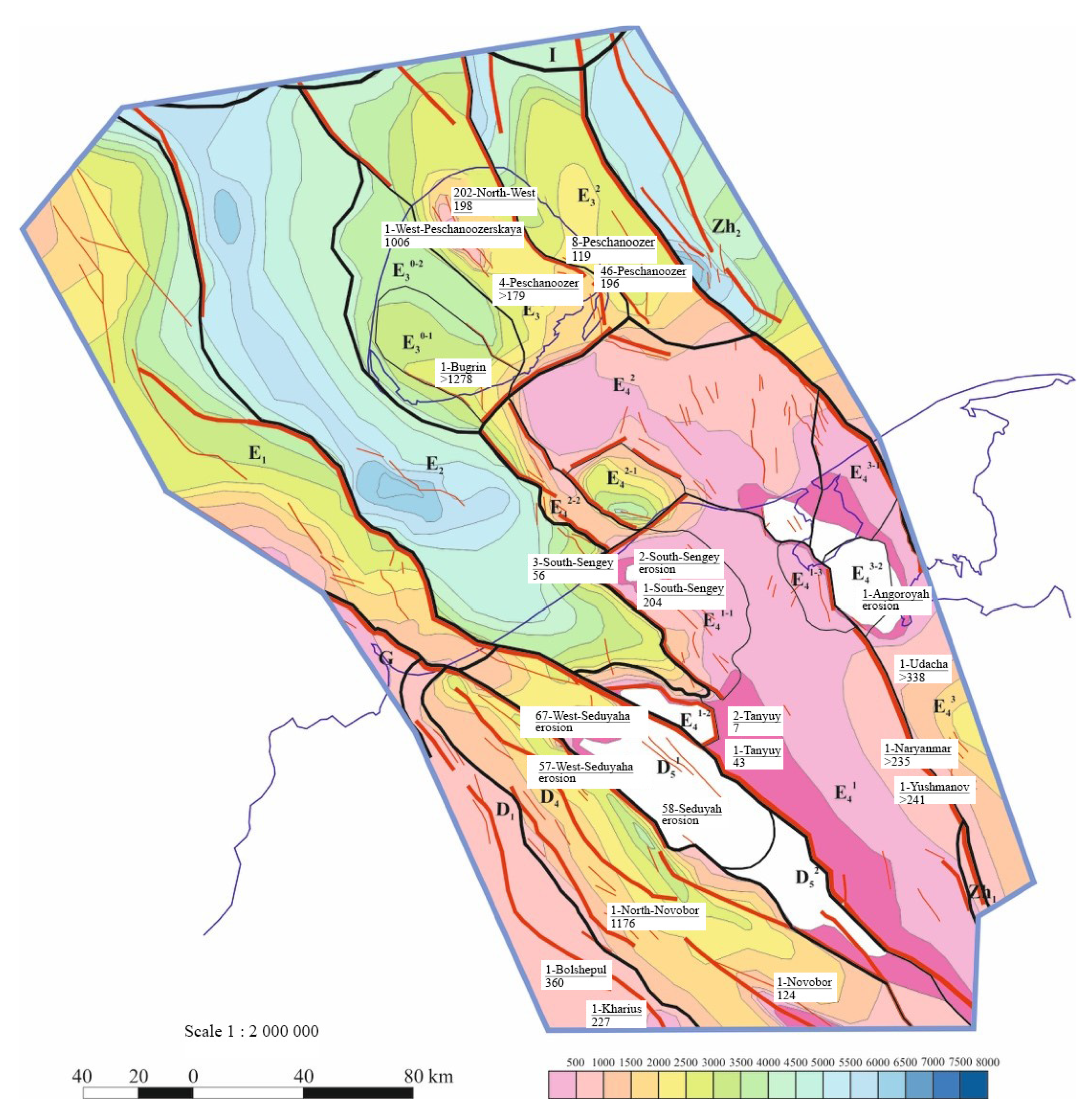
The oil and gas potential of the Lower Permian and Lower Middle Triassic deposits has been established within the OGR. The Peschanoozerskoye and Tarkskoye deposits on Kolguev Island have been identified. The highest productivity was noted in the Triassic sandstones of the Peschanoozerskoye deposit at depths of 1300–1600 m. The prospects of the search are mainly associated with low-amplitude and medium-sized structures in the development zones of natural reservoirs with a mainly terrigenous composition.
6. Development of the Structural Frame
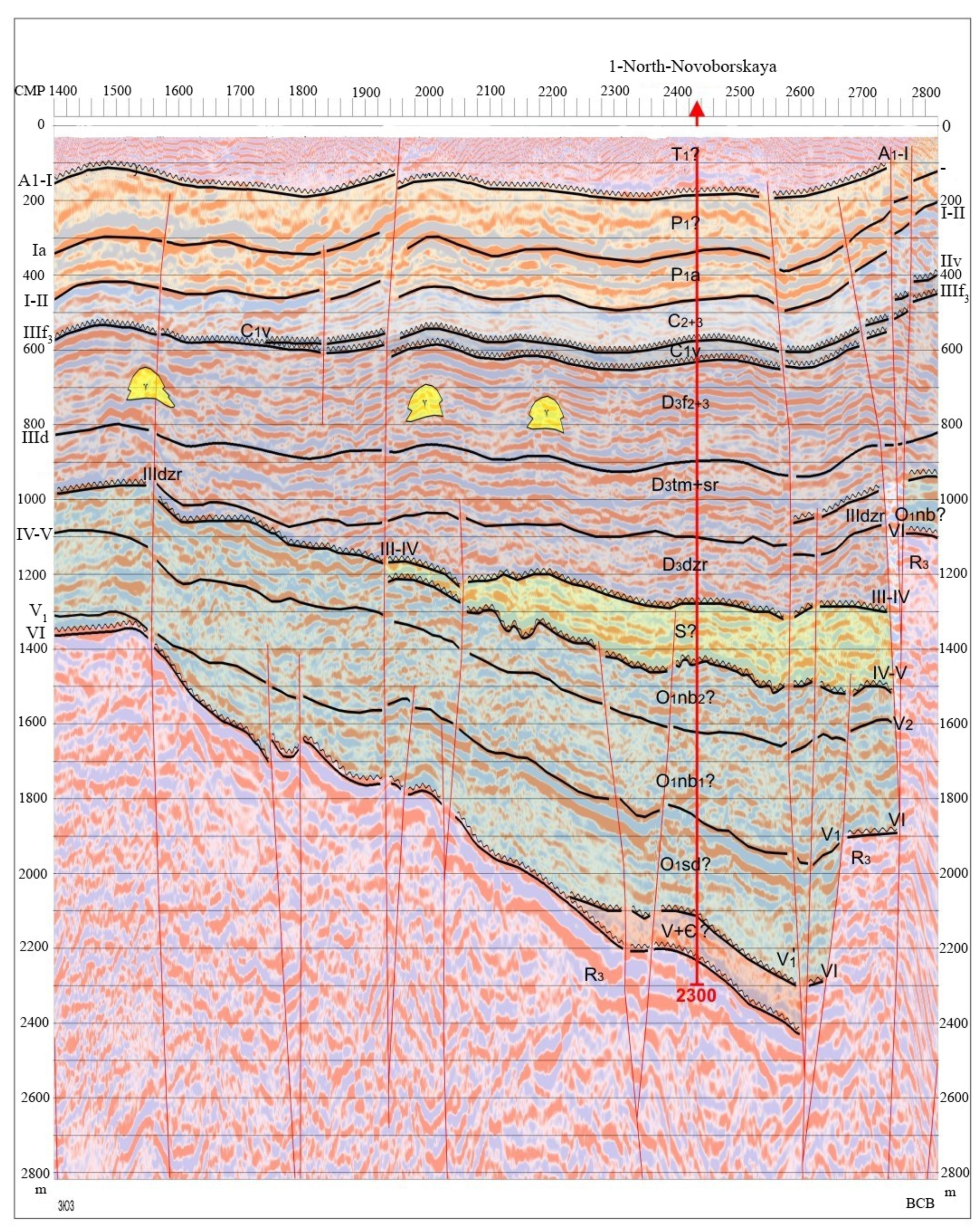
In the waters of the Pechora Sea and in the area of its junction with the land of the Timan–Pechora province, a modern complex of seismic exploration regional works was carried out, which made it possible to significantly refine the geological and geophysical model of the structure of the northwestern part of the Timan–Pechora oil and gas province and its marine continuation in the waters of the Pechora Sea.
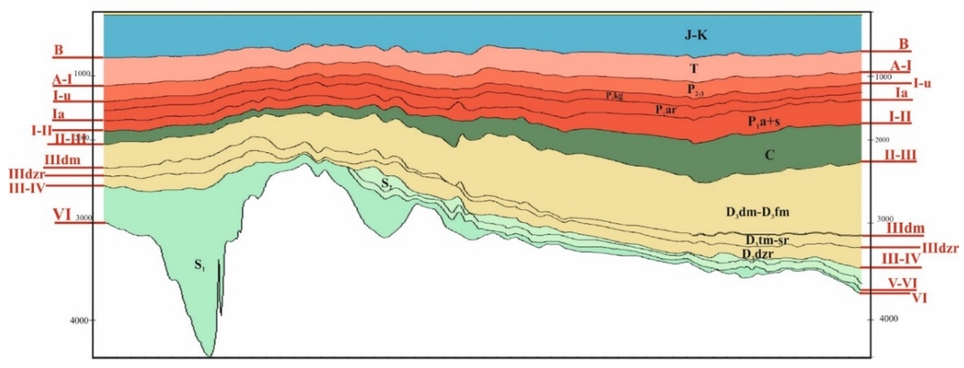
Interpretation of seismic data and borehole materials was made for the purpose of structural constructions on reflecting horizons (RH): VI (foundation surface), V-V1 (acoustic roof surface of Ordovician terrigenous deposits), IV (roof of Silurian deposits), III-IV (roof surface of Silurian-Lower Devonian deposits of different ages), III2 (surface of Middle Devonian-Lower Frasnian deposits), IIIdm (solely Domanik deposits), IIIfm1 (acoustic surface of Famennian deposits), IIv (roof surface of Visean deposits of the lower carboniferous), Ia (horizon, separating the carbonate and terrigenous part of the Lower Permian), A-I (the roof of the Lower Triassic), and B (the horizon in the Jurassic sediments). The seismogeological model created in the PC Kingdom was the basis for clarifying the tectonic and oil and gas geological zoning of the northern part of the Timan–Pechora province, including the waters of the Pechora Sea (
Figure 3).
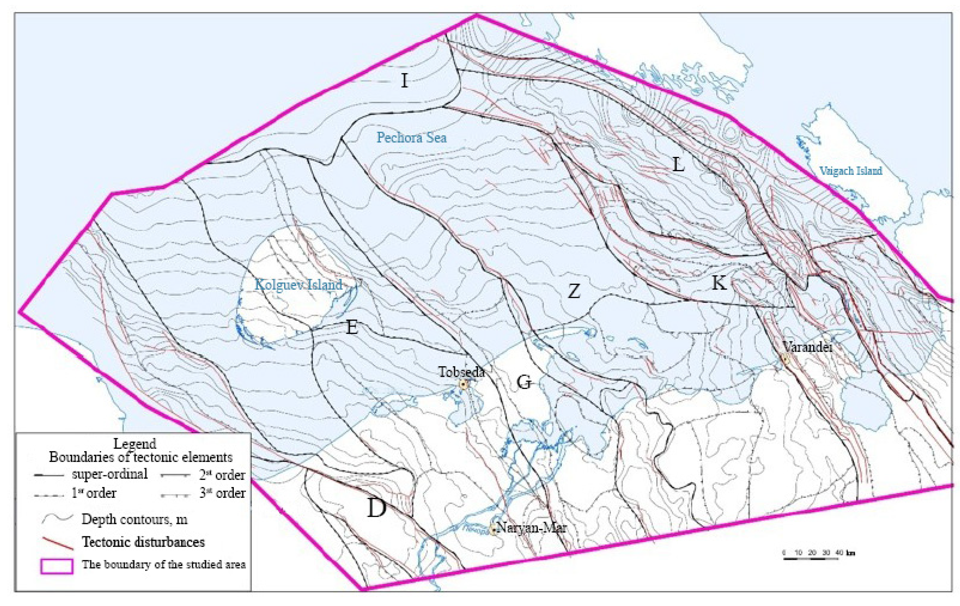
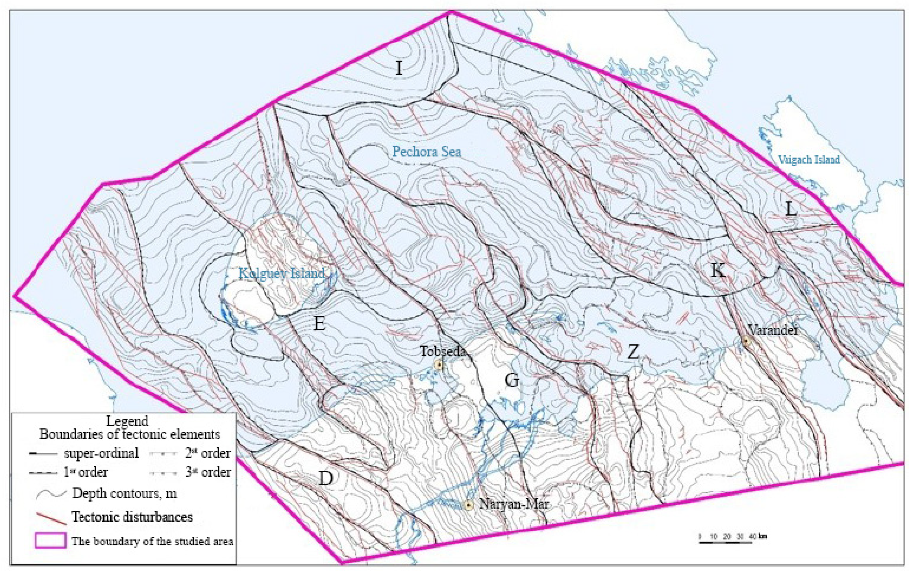
The boundaries of the main tectonic elements were significantly clarified (Izhma–Pechora syneclise (north), the Malozemelsko–Kolguevskaya monocline, the Pechora–Kolva aulacogen (north), the Khoreyversko–Pechoromorskaya syneclise, the North Pechoromorskaya monocline, the Pripaikhoysko–Priyuzhnonovozemelsky trough, and the Gulyaev–Varandeyskaya structural-tectonic zone) primarily in the water part of the research area, and their subordination was established by the nature of the relationship. The discrepancy between the structural plans on the surface of the sedimentary cover and the surface of Permian-carbonates was then established, which determined significant differences in the control of oil and gas content of different structural stages (
Figure 4 and
Figure 5).
The correlation of well sections along the lines of regional profiles allowed us to identify the features of the development of oil and gas complexes.
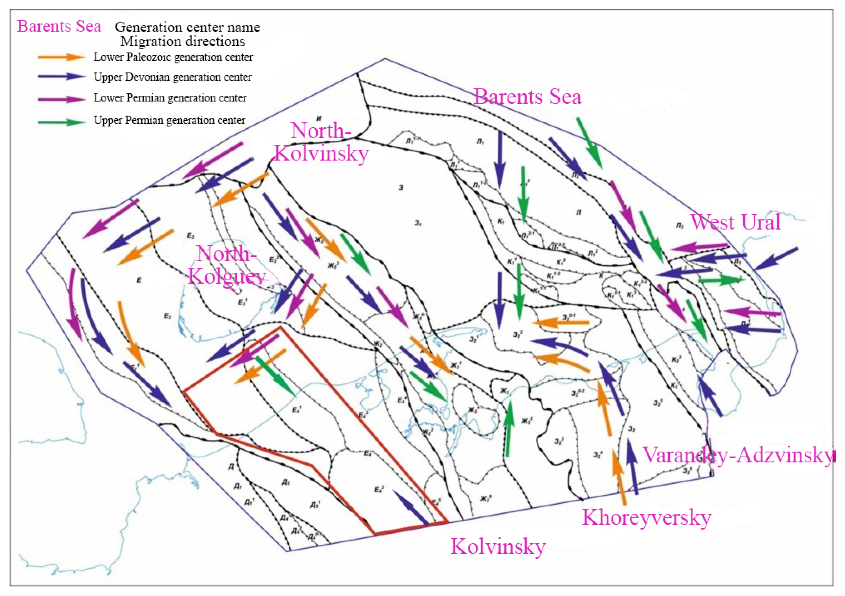
The restoration of the history of immersion and the isolation of oil and gas systems (the evolution of HC generation centers), noting the catagenetic zonality for the Barents Sea and North Kolguev generation centers, allowed us to draw conclusions about the zonality in the distribution of the phase composition of fluids in the water part of the basin (mainly oil fields were identified in the eastern part; gas and gas condensate fields were identified in the western part). It is assumed that there could be several centers of oil and gas formation, including the possible influence of the Domanik-Famennian oil and gas source rocks, located to the north of Kolguev Island.
Regional structural constructions made it possible to clarify the tectonic and oil and gas geological zoning (
Figure 6) [
46,
47].
7. Promising Oil and Gas Complexes and Oil and Gas Generating Strata of the Lower Paleozoic Part of the Section
The composition, structure, and ratio of rocks comprising natural reservoirs (NR) are determined by their genesis: the origin of certain types of precipitation, the frequency of sedimentation, the nature of secondary transformations. The genetic approach is an effective method of forecasting reservoirs as a whole and its individual elements. The most significant formation with generation potential is the Domanik-Famennian-Tournaisian complex. It also includes the Domanik oil and gas generating strata, which is fundamental for the province; its potential for oil is estimated at 70% of its contribution to the formation of TPP deposits, and more than 50% for that of gas.
In the sedimentary cover within the studied area, the Cambrian Lower-Middle Ordovician terrigenous, Middle Ordovician-Lower Devonian terrigenous-carbonate, Middle Devonian-Frasnian terrigenous, Domanik-Tournaisian carbonate, Upper Visean-Lower Permian carbonate, and the Upper Permian and Triassic terrigenous sediments that promise oil and gas complexes are distinguished from the bottom to the top [
5,
39].
7.1. Cambrian-Lower-Middle Ordovician Terrigenous Complex
The basal Lower-Middle Ordovician terrigenous complex is established on the Bugrinsky dome in the East Kolguevsky block and is assumed to be in the West Kolguevsky trough on the basis of the general patterns of development of quartz sandstone formations in posthumous post-Baikal subsidences known in the south in the Izhma-Pechora syneclise. The thickness of this complex in the depocenter of the deflection, which reaches up to 2.0 km on the tops of the Sengei Mountain and the South Sengei Dome, is reduced to tens of meters.
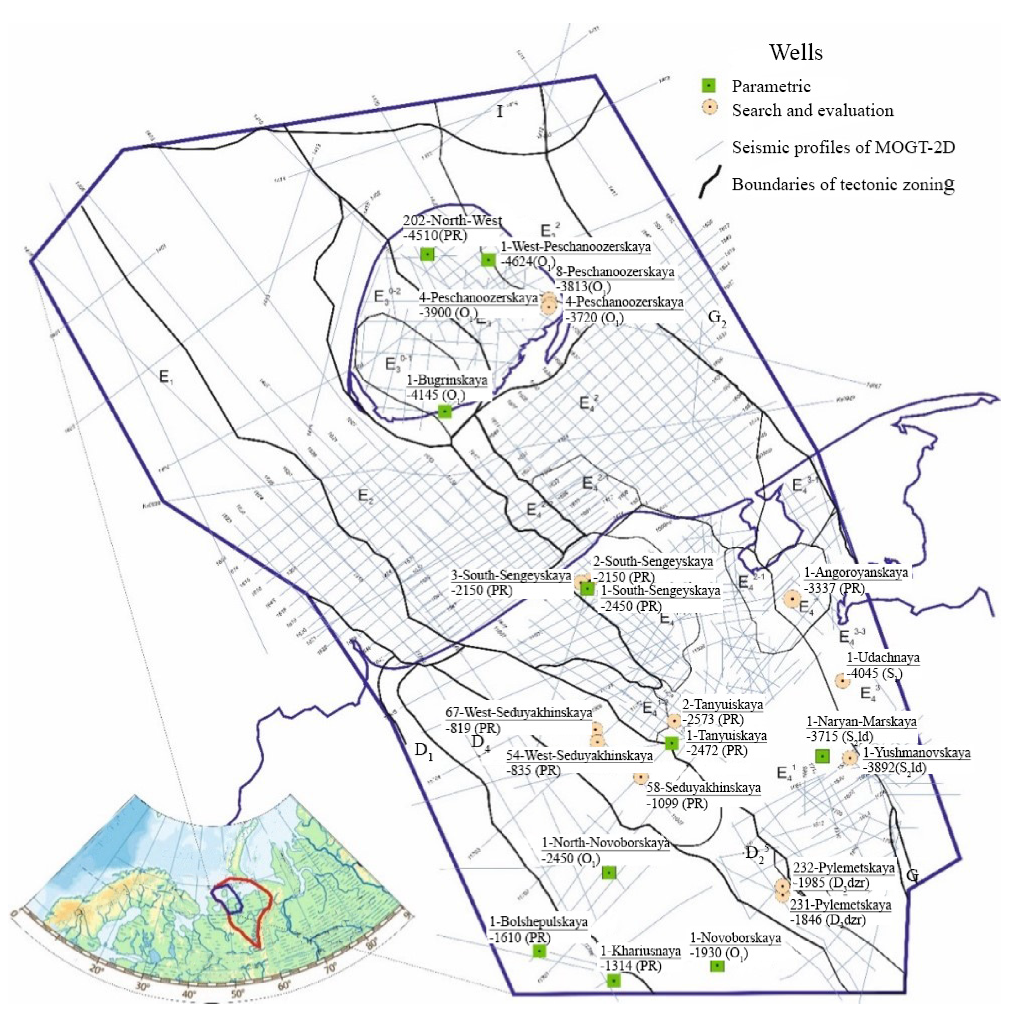
Terrigenous Ordovician deposits are characterized by data from drilling wells in the areas: No. 1–Bugrinskaya, No. 1—Bolshepulskaya, No. 1, 2—Khariusny, No. 1—Novoborskaya. They are mainly represented by terrigenous sediments of considerable capacity. The development within the studied area is limited mainly by the West Kolguevsky paleodeflection as well as by the paleotrough located along the Timansky ridge.
Within the water area, the oil and gas complex (OGC) is represented in the volume of the Upper Cambrian Lower-Middle Ordovician deposits (Sedjel formation of the Tremadocian stage, the Nibel formation of the Arenigian stage, and the conditionally isolated Lanvirnian stage). The deposits of the complex with angular disagreement lie on the foundation of the Proterozoic age and are represented by sandy-clay deposits of the littoral and supralithoral. It is assumed that the development of the complex in the modern water area is wider than on land. The presence of the Middle and Upper Ordovician is established in the West Kolguev trough, where the presence of Lower and Middle Devonian is also assumed in its uncompensated central-part formations of coastal-marine and deltaic sandstones. The thicknesses of the complex vary from 1.5–2.0 km in the West–Kolguevsky trough, to 0.5–1.5 km on its slopes. It is completely absent on the Bugrinsky buried dome (north of the Bugrinsky stage) and on the local elevations of the Sengei shaft and the Udachnaya stage. The lithological composition of the complex naturally changes from terrigenous-carbonate to the west and south of Kolguev Island, to mainly carbonate in the north of the Udachnaya stage. A characteristic feature of the sedimentation conditions is the compensated filling of the basin, which was provided by the demolition of detrital material from the Timan and the elevated Malozemelsky block. The most powerful section of the undifferentiated Sediol and Nibel formations of the Lower Ordovician, and possibly the Middle Ordovician terrigenous deposits with a total capacity of at least 1278 m, was opened by well No. 1—Bugrinskaya on Kolguev Island. In the upper part of the section, the role of significantly clayey, carbonate-clay bundles with a thickness of 5–40 m separating sand layers with a thickness of 5–120 m is noticeably increasing.
7.2. Middle Ordovician-Lower Devonian Terrigenous-Carbonate OGC
The province is allocated with deposits in the volume of the Upper Middle-Upper Ordovician, the Silurian and Lower Devonian, and in the volume of the Lower and Upper Silurian and Lower Devonian of the studied area. The deposits of the Lower Silurian (Lower Devonian), represented by carbonate and terrigenous rocks, were discovered by drilling only in the Naryan–Marsky, Udachnaya, and South–Sengei areas. The boundary of the complex is erosive and corresponds to the surface of the Lower Devonian, Silurian, and Ordovician deposits of different ages. The complex is very limited in distribution within the land of the studied area, and more significantly, in the water area. At the same time, its volumes are incomplete due to the partial erosion of the Lower Devonian, preserved only in the Western Kolguevsky trough and in the northeastern part of the Udachnaya stage [
48].
Silurian deposits within the research area were discovered only on the Malozemelsko–Kolguevskaya monocline, where it has a predominantly carbonate composition and a total thickness from 0 to 500 m. In the volume of the Silurian system, the lower and upper sections are distinguished.
The deposits of the Lower Devonian are represented by fragmentary deposits of the Lohkovsky stage, presumably in the volume of the Ovinparmian horizon only in the extreme eastern sections of the research site. Its presence in the section is proved by drilling data on the Peschanoozerskoye area in wells No. 4 (thickness, 46 m) and No. 46 (thickness, 256 m). The rocks are represented by carbonate-clay and sulfate-carbonate-clay deposits in lagoons in the West Kolguevskaya depression and the Peschanomorskoye structural zone.
7.3. Middle Devonian-Frasnian Terrigenous OGC
The complex in the work area has a reduced stratigraphic volume. According to seismic data, there are practically no deposits of the Middle Devonian within the studied object. The Middle Devonian sandstones are assumed to be present only in the West Kolguevsky trough. The Lower Frasnian subcomplex (Dzhersky horizon) is almost ubiquitous and has been opened by wells of the Tanuyskaya, Pylemetskaya, and South Sengei areas. The thickness of the horizon reaches 150–200 m. Timan–Sargaev carbonate-terrigenous deposits cover the entire territory of the considered area, but due to significant sandiness they sometimes lose their qualities of a regional cover, preserving them in the east and locally in the West Kolguevsky trough (
Figure 7).
Above the section lies the Domanik-Tournaisian terrigenous-carbonate OGC, which is not the subject of study.
Sedimentation conditions and patterns of distribution of natural reservoirs and oil-generating strata.
The composition, structure, and ratio of the rocks comprising the NR are due to its genesis: the origin of certain types of precipitation, the frequency of sedimentation, and the nature of secondary transformations. The genetic approach is an effective method of forecasting reservoirs as a whole and its individual elements (
Figure 8 and
Figure 9).
On the basis of a comprehensive interpretation of geological and geophysical data within each oil and gas complex, the patterns of distribution of reservoir rocks and fluid traps forming natural reservoirs of various scales have been revealed.
7.4. Natural Reservoirs of the Lower-Middle Ordovician Terrigenous Oil and Gas Prospective Complex
The reservoir strata accumulated in the mode of compensated sedimentation. The alternation of layers with different filtration-thickness characteristics is rhythmic in nature due to the seasonal cyclicity of their sedimentation and/or the uneven speed, and possibly the multidirectional nature of the shoreline at the initial stages of filling the basin. Bundles with optimal reservoir potential are confined to the tops of rhythms corresponding to the formation of “washed” precipitation during relatively calm periods of sedimentation. In the sandstones of the Lower Ordovician interval, similar in genesis to the south of the Izhma-Pechora syneclise (well No. 1—Sosyanskaya, No. 40—Khabarikhinskaya, No. 1—Dvoynikovaya), sandstone reservoirs are characterized by an open porosity coefficient of 20% (according to the sections). According to the results of laboratory studies of the core, the open porosity goes up to 14%, and the permeability ranges from 3.3 to 6.8 m up to 519 mD.
At the last stages of compensated filling, the Ordovician bay morphologically represented a peneplenized littoral-supralithoral zone. The leveled bottom relief and impeded water exchange over large areas caused the formation of substantial clay deposits (the Nibel formation) with sufficient thickness, which have satisfactory screening properties and can act as clay screens with a local and possibly a zonal distribution. It should be noted that in the clay column, there may be low-power sand–silt interlayers associated with the seasonal activation of sedimentation, and/or interlayers of carbonate–clay composition caused by the periodic or seasonal increase in salinity of the basin waters. In both cases, the reliability of the cover is reduced. These interlayers can act as a reservoir with a low filtration capacitance potential. The NR of the Lower-Middle Ordovician terrigenous complex can be characterized by a three-layer structure.
Noting the power of the scattering thickness (up to 300–400 m), with the exception of areas where there are no Nibel deposits, hydrocarbon deposits can be confined to high-amplitude structures. Since the Sediol formation strata most likely do not have their own oil-generating potential, the deposits are most likely near fault zones, where younger Silurian (Upper Silurian) deposits containing a sufficient total amount of organic matter are hypsometrically lower than the Lower Ordovician reservoirs.
In the volume of the regionally isolated Upper Ordovician-Lower Devonian terrigenous-carbonate OGC within the object of study, the Silurian carbonate and Lower Devonian carbonate-terrigenous subcomplexes were identified. There are no carbonate deposits of the Upper Ordovician in the studied area.
7.5. Natural Reservoirs of the Silurian Carbonate Subcomplex
The oldest deposits of the complex, uncovered by wells in the area under consideration and in adjacent areas, are of Lower Silurian age.
Facies of the littoral zone with mixed sedimentation, represented by variegated gray colored carbonate-terrigenous sediments, are found on the South Sengei ledge and on the Tanuyskaya area.
In the variegated gray colored carbonate-terrigenous formations of the Lower Silurian, the reservoirs are of quartz sandstone layers.
The presence of reservoirs in the Silurian deposits of the object was also confirmed further north in well No. 3—South-Sengei, where 11 reservoir layers with an effective capacity from 2.4 m to 5 m, and porosity from 5–8% to 12–16% were identified.
A comprehensive analysis of drilling materials and the results of field-geophysical studies allowed us to identify two main groups of development zones of the Silurian natural reservoirs. The first is the development zone of terrigenous-carbonate low-medium-thickness reservoirs under the regional Timan–Sargaev cover, spatially connected with high projections of the foundation (South Sengei and Tanuyskaya areas). On the Tanuyskaya area, Silurian rocks most likely form a hydrodynamically connected (single) reservoir with Dzhersky sandstones. On the arches of the paleomorphological ledges, the hydrodynamic activity of the waters was quite active, which led to the accumulation of desiccated sediments and significantly reduced the fluid-resistant properties of the cover.
The second group (II) is the development zone of carbonate low-medium-thickness reservoirs under the regional Timan–Sargaev and intraformational Silurian (Upper Silurian) cover. It is spatially connected with the development zone of shelf facies in the eastern part of the object and in its water area.
7.6. Natural Reservoirs of the Lower Devonian Carbonate-Terrigenous Subcomplex
The Lower Devonian interval of the section is absent from the sections of the wells of the studied area. The forecast of the complex reservoirs was carried out on the basis of data from seismic materials analyzed from the point of view of regional patterns of development of the Timan–Pechora paleobasin.
The nature of sedimentation in the Lower Devonian was due to extensive regional regression.
The zones of possible reservoir development are associated with areas of increased thickness (depocenters) of the Lower Devonian sediments, which (according to the basic principles of the paleogeomorphological method) can be considered as the main directions for forecasting sand formations (lenses, layers). The reservoir characteristics of sandstones can be significantly reduced by the abundant clay and/or carbonate-clay cement expected in the sediments of reservoirs with difficult water exchange.
In the north-western regions of the object, the possible presence of local, low-thickness, and mainly terrigenous NR of a complex type, which are lenticular and possibly mantle-shaped, is predicted.
The screening strata of the local type in the Lower Devonian complex are most likely of poor quality, associated with their significant carbonate content and areas, possibly comprising sulphate.
7.7. Natural Reservoirs of the Middle Devonian-Lower Frasnian Terrigenous Oil and Gas Complex
The Middle Devonian-Frasnian sub-Domanik oil and gas complex in the work area has a reduced stratigraphic volume. According to seismic data, there are no deposits of the Middle Devonian within the studied object. The Lower Frasnian subcomplex is almost ubiquitous and has been opened by wells of the Tanuyskaya, Pylemetskaya, and South-Sengei areas.
By its origin, the Lower Frasnian reservoir is polyfacial: coastal-marine and shallow-shelf. The reservoir potential is mainly associated with the Dzhersky and Lower Timan intervals, which, in the absence of the Middle Devonian, acquire the value of a search object [
49,
50].
The Dzhersky terrigenous deposits formed under coastal conditions with sufficiently active hydrodynamics in the shallow shelf that existed in most of the studied territory. The Dzhersk formations are characterized by the high sandiness of the section as well as the presence of laterally sustained and most likely mantle-shaped sand bodies with good reservoir potential. Reservoirs are mainly pored. The open porosity can vary from 5–6% to 15–18%. The permeability is intergranular.
The Dzhersky and Lower Timan sand layers, overlain by clays of the Upper Timan–Sargaev age, form a single hydrodynamically connected reservoir. The reservoir potential of this stratum is confirmed by the results of testing in wells.
8. Basin Modeling
The natural geological bodies of the formation level—where the processes of oil and gas formation that took place (and/or are taking place) are oil and gas source formations or horizons (OGSH)—are responsible for the oil and gas potential of various regions. The total oil and gas-producing potential of a particular oil and gas basin (OGB) should be estimated by the amount of OM contained in OGSH. The OGSH are characterized by certain concentrations of OM, types of OM, and a certain volume, i.e., thickness and area of development, as well as the maturity of OM (catagenesis). In order for OGSH (or their combination) to become a focus of oil and gas formation (OGF), the minimum values of HC migration densities from them should be at least 50 thousand tons/km2 (50 million nm3/km2) under ideal accumulation conditions (the immediate vicinity of the reservoir and its optimal thickness). In general, the border focal density of migration can be assumed to be 100 thousand tons/km2 (100 million m3/km2). In order to identify the localization of OGF, it is necessary to determine the area of development and the thickness of the OGSH as well as the concentration of OM (Corg) in them; it is also necessary to identify the degree of catagenesis of OM, and with the use of the created models of the generation-migration of HC, to calculate the scale of migration for the type of OM corresponding to this OGSH.
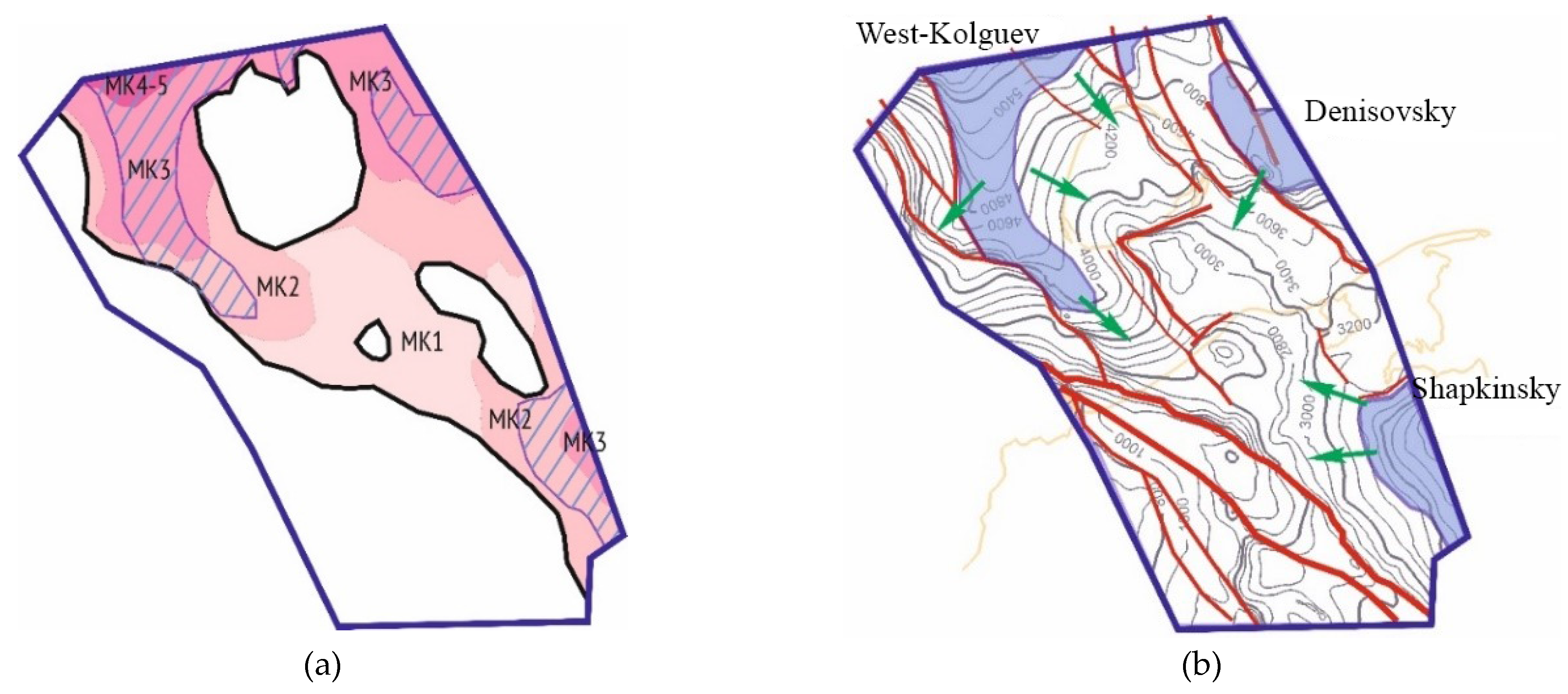
On the territory of the TP SB, the Domanik-Tournaisian formation and the Silurian formations (29% and 25% for oil, respectively) play the main role in terms of the scale of oil and gas formation; Lower Permian formations (12% for oil and 22% for gas) can be attributed to less significant ones.
The Domanik-Tournaisian formation was continued from the continent to the sea on the basis of facies constructions and seismic data, according to the results of which reef bodies were identified, outlining the zone of the pre-reef facies of the sublatitudinal strike. Thin layers of domanikoid rocks are found in the section of the clay-carbonate deposits of well No. 1—Pakhancheskaya, which is typical for some areas of the reef facies near the reef body [
50]. These interlayers are enriched with OM and are not of interest from the standpoint of large-scale oil and gas formation, but they indicate the relative proximity of the development of domanikoids of the formation scale. The thickness of the Domanik OGSH increases in general from west to east—from 20 to 300 m—as the age range of the formation expands. The average concentrations of Corg vary in the range of 0.6–1.5%. In the work area, the Domanik-Tournaisian OGSH is characterized by the following degrees of catagenesis of OM: MK21 and MK22 [
49].
The mudstones of the Lower Ordovician and Upper Cambrian are characterized by shallow-sea facies formation conditions and sapropel organic matter. At the same time, a large proportion of algal OM is noted in Ordovician samples. The degree of transformation of rocks according to bituminology remains relatively low, but the correctness of these definitions is questionable, especially given the large spread of analysis results.
The modern geothermal regime of the TP SB is characterized by the relatively low intensity of the thermal field; the average geothermal gradients in the section do not usually exceed 2.5 °C/100 m [
25]. In the TPB, the so-called abbreviated (“subdonets”) zonality of the catagenesis of OM [
49] was established due to the intense geothermal regime in the past (paleogradients of the order of 5 °C/100 m), which is characteristic of Paleozoic basins.
Table 1 shows the paleodepth dimension of such a scale compared with measurements of the reflectivity of vitrinite R
a (measurements carried out in oil) and R
o (measurements carried out in air) (
Table 1) [
49,
50].
The scheme of the distribution of the centers of oil and gas generation of hydrocarbons in the water area of the Timan–Pechora basin is shown in
Figure 10.
The thicknesses of the OGSH of the Silurian complex in the work area vary in the range of 50–400 m, while the direction of thickness changes and their gradients are aligned with the seismic map of the total thicknesses of O
2-D
1. Average concentrations of C
org in the OGSH (S
1-2) vary in the range of 0.25–0.60% (isocarbs 0.3; 0.5). The organic matter in the Silurian OGSH is characterized by the degree of catagenesis of MK
3 (
Figure 11).
In most of the territory of the TBP, the catagenetic scale has a shortened, so-called subdonets character corresponding to the maximum paleogradient of 5 °C/100 m. The scale is justified by numerous data on the definitions of the reflectivity of vitrinite.
The data of analytical geochemical studies made it possible to create a basin model for the studied region. The modeling of the processes of generation, migration, and accumulation of hydrocarbons was carried out using the TemisFlow software package. The geological history of the basin is modeled with backstripping technology, which involves restoring the history of the basin’s dives by sequentially removing structural horizons. The modeling of the geochemical history is carried out based on the kinetic model of hydrocarbon transformation based on the work of the French Institute of Petroleum (IFP). The applied modeling method makes it possible to link disparate geochemical and structural materials to assess the qualitative characteristics of oil and gas source rocks and the degree of realization of their potential, as well as to obtain approximate but reasonable quantitative data on the scale of generation and migration of hydrocarbons.
As a result of the work carried out to assess the oil and gas source potential in the Lower-Middle Paleozoic section of the MKM, the main prospects for the formation of possible hydrocarbon accumulations are associated with Silurian oil-producing strata. It was not possible to separate the Lower and Upper Silurian deposits at the research site, and the characteristics of their oil and gas production potential are given together.
To the west of the fault separating the structures of the Pechora–Kolva Aulacogen from the Malozemelsko–Kolguevskaya monocline, a band of the absence of oil and gas source strata is mapped. The scale of the thicknesses of the OGSH of the Silurian complex in the work area is 50–400 m, while the direction of change in thicknesses and their gradients are aligned with the seismic map of the total thicknesses of O2-D1. Average concentrations of Corg in the OGSH (S1-2) vary in the range of 0.25–0.60%.
To create the model, the constructed structural maps for the main reflecting horizons and thickness maps between them were used, the degree of erosion as a result of large interruptions in sedimentation was estimated, and prospective source strata, forecast reservoirs, and fluid barriers of the lower structural floor of the MKM were estimated (
Figure 12).
At the initial stage of the work, the 1D modeling method was also used to evaluate the catagenetic transformation of the OM according to deep-drilling data. The modeling of the temperature history of catagenetic changes in rocks was based on T.K. Bazhenova’s opinion that in Paleozoic basins, there was a reduced catagenetic zonality due to an increased paleogradient of temperatures of up to 4.5–5.0 °C/100 m, as well as data on the modern thermal gradient for mobile foundation blocks (which was the MKM) at 2.4–2.7 °C/100 m [
6,
46].
To assess the reliability of fluid traps and the generation potential of oil source rocks, the results of the logging data analysis for deep wells extrapolated to the territory of the entire site were used. The surfaces of fluid traps and oil source rocks were calculated by the method of convergence in the gap between the main structural horizons, by a proportional division of the thickness between the main deep surfaces. The correction of the depth reference was made based on the borehole data, where it is possible. To assess erosion, it was assumed that the maximum apparent thickness of the eroded complex was almost equal to the thickness of the complex before erosion. Furthermore, the amount of erosion was calculated as the difference between the maximum thickness and the current thickness. At the same time, the paleoterrain at the time of the formation of the analyzed complex was noted, and the thickness of the filling of paleotroughs was excluded from the calculation, for which the correlation of additional horizons was performed [
40,
48,
50].
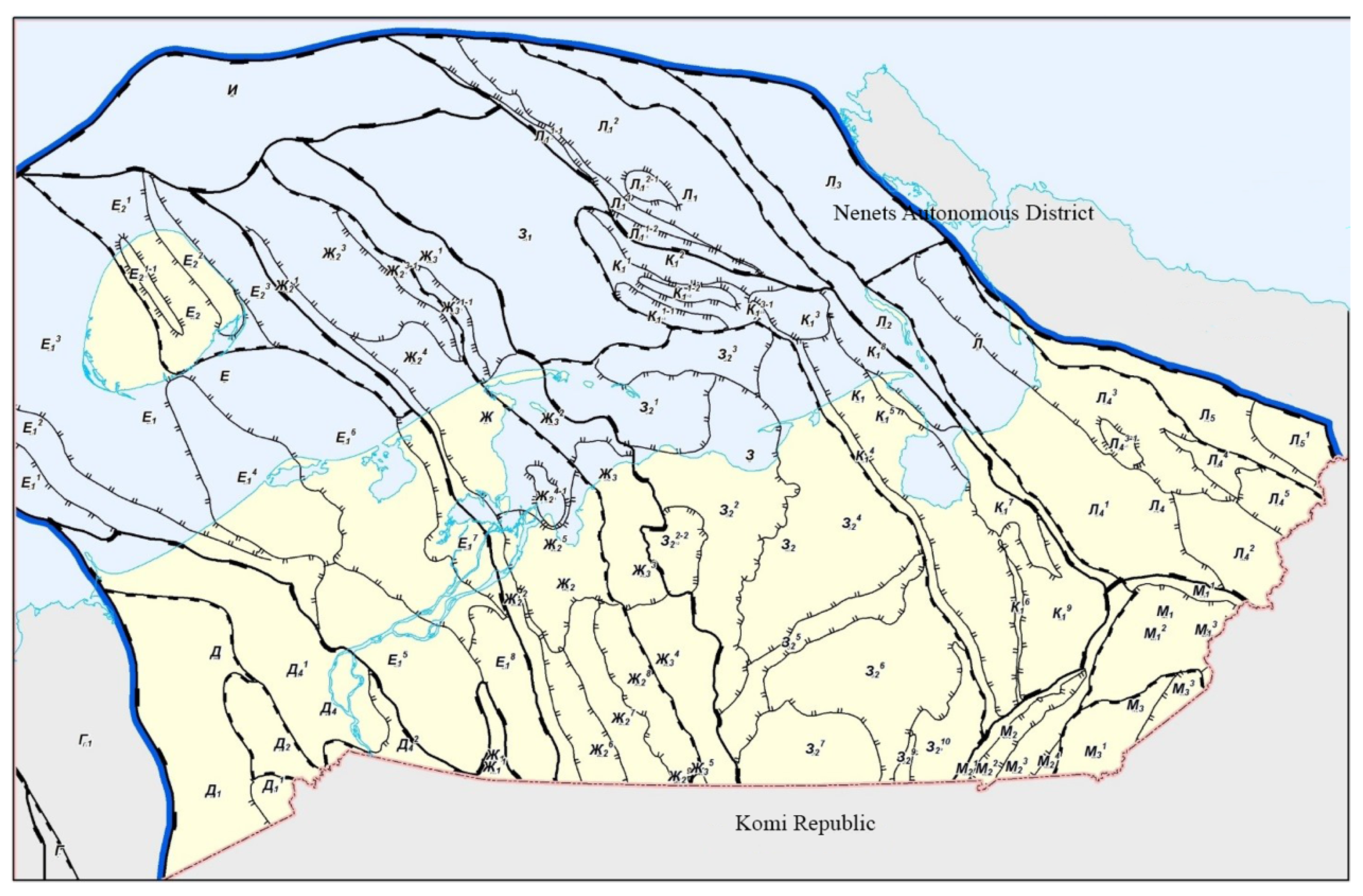
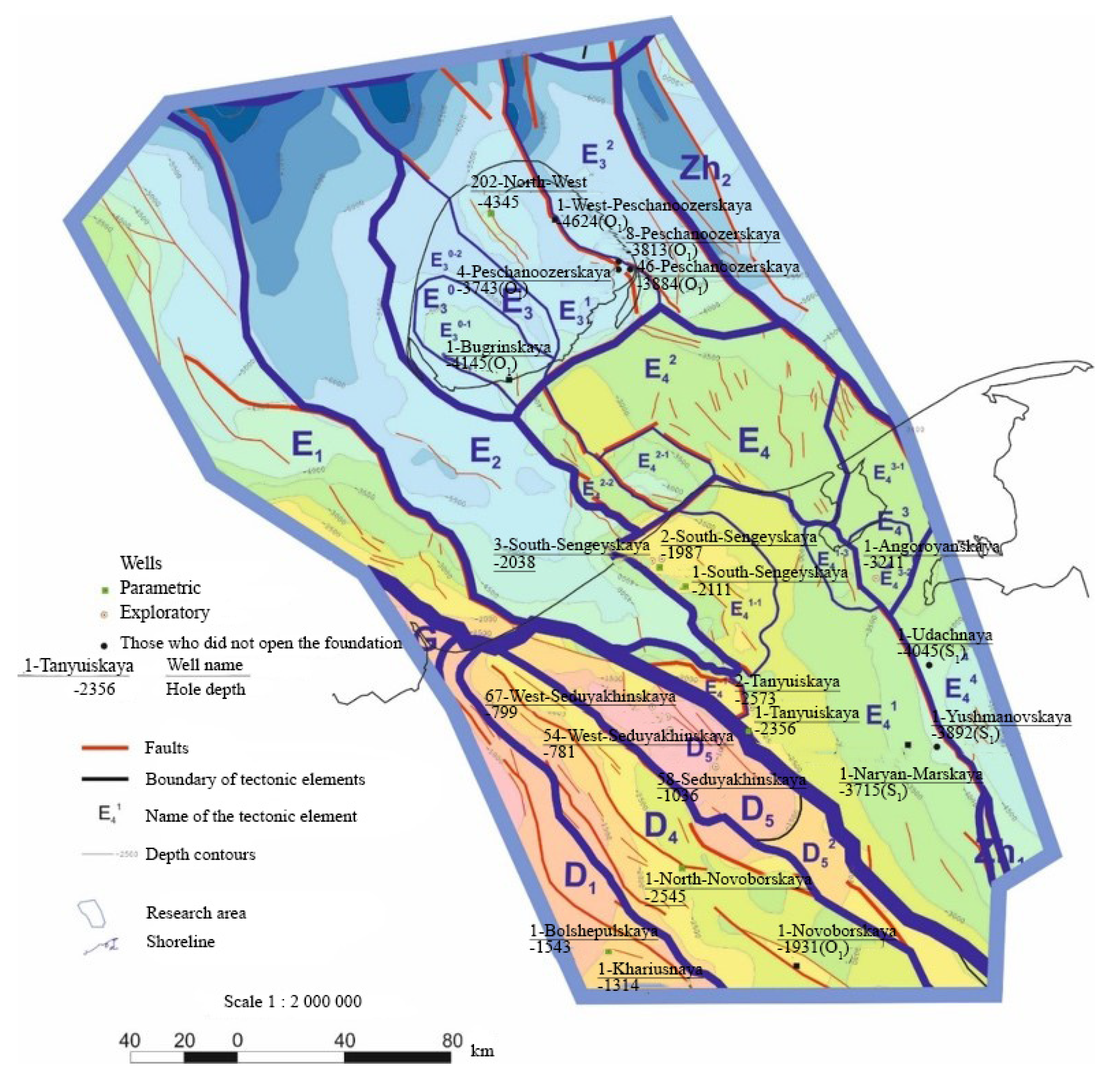
Tectonic elements: Suborder: G—Timan ridge, D—Izhma–Pechora syneclise, E—Malozemelsko–Kolguevsky megablock (monocline), Zh—Pechora–Kolva megablock (aulacogen), I—North Pechora Sea monocline; 1st order: D1—Neritsky stage, D4—Novoborsko–Sozvinskaya structural zone, D5—Seduyakhinsko–Malolebedinsky disjunctive megalithic bank, E1—Korginskaya stage, E2—West–Kolguevskaya depression, E3—Kolguevsky block, E4—Malozemelsky block, Zh1—Pechora–Kozhvinsky graben, Zh2—Denisovsky block; 2nd order: D51—Seduyakhinsky disjunctive shaft, D52—Seduyakhinsko–Yantygsky bridge, E30—West Kolguev uplift, E31—Kolguev structural zone of horsts and grabens, E32—Peschanomorskoye structural zone, E41—Naryan–Marsky stage, E42—Udachnaya stage, E43—Kharitseysko–Shapkinskaya stage; 3rd order: E30-1—Bugrinsky dome, E30-2—West–Bugrinsky stage, E41-1—South Sengei dome, E41-2—East Seduyakhinsky ledge, E41-3—Nerut graben, E42-1—Sengei graben, E42-2—Sengei horst, E43-1—Khareysky stage, E43-2—South Anorgayakhsky dome.
The basin model was carried out on the basis of the data on the geochemical characteristics (including lithology, type of organic matter, and the history of immersion).
It was revealed that the organic matter in the Silurian OGSH in the work area is characterized by a degree of catagenesis from MK
2 to MK
3, while only in the extreme northern periphery is it up to MK
4-5. The main center of generation is shown in
Figure 13.
The identification and substantiation of oil source strata in the modeling process was a difficult task due to the small size of the work area and its marginal position in the oil and gas basin. Belonging to the reservoir, fluid trap or oil source strata was determined based on the lithological characteristics of the strata and the content of C
org. Bundles in the Upper Silurian and Upper Devonian Domanik deposits have been tested as oil and gas source strata [
3,
47,
49].
The Upper Silurian deposits in the work area are a layer of clay-carbonate interlayer, which was studied in natural outcrops along the Dolgaya River. An analysis of the GC curve of well No. 1—Naryan–Marsky allowed us to take the thickness of the interlayers with the oil source potential as 1/3 of the total thickness of the Upper Silurian deposits. The Lower Devonian sediments developed locally; they do not have widespread distribution. Their development is associated with the most loaded sections of the pre-Timan structural stage.
9. Conclusions
Based on the interpretation of the results of seismic surveys carried out in the north-western part of the TPP, including its water areas, a generalization of the results of deep drilling that included parametric well No. 1—Severo-Novoborskaya, structural maps, and thickness maps of all seismic facies complexes developed in the territory and the water area—which were used in basin modeling with the Temis software package for the purpose of reconstructing the conditions of immersion and the transformation of potential oil and gas formations—has been significantly refined, the most promising of which is the Silurian OGSH.
According to the created basin model, the total mass of hydrocarbon matter generated only by the oil source strata of the work area is 3.17 billion TOE. In addition, the modeling allowed us to get an idea of the time and conditions needed for the formation of large zones for the possible accumulation of hydrocarbons. Zones of HC paleoaccumulation are predicted based on their space–time relationships with possible centers of generation, on comparisons with periods of the intensive generation of HC both from space directly located within the work area and beyond (noting the possible migration), and on migration directions. It is concluded that it is necessary to search for transit routes of HC migration from the gas formation center located in the water area and the HC generation center located within the Pechora–Kozhvinsky megalithic bank.
According to the constructed model, the total generated mass of the HC substance within the work area is 3.17 billion tons of HC. This value displays the mass of hydrocarbons generated only by the site’s own oil source strata, and it does not take into account hydrocarbons that could migrate from the outside, from the Pechora–Kolva aulacogen, or from the area north of Kolguev Island from the Domanik OGSH.
The conducted research allowed us to identify promising zones of oil and gas accumulation (PZOGA), spatially confined to the western slope of the West Kolguevskaya depression, the Sengei ledge, the zones of articulation of the Naryan–Marsky stage with the Nerut graben, and the Seduyakhinsky shaft. These PZOGA are considered as the primary objects of exploration for hydrocarbon deposits in the Middle Ordovician-Lower Devonian and Middle Devonian-Lower Frasnian oil and gas complexes. The most important geological feature of the development of these complexes is the formation of extended traps of the stratigraphic type (sometimes with tectonic shielding), which allows us to hope for the formation of large zones of hydrocarbon accumulation located in the frontal part of the migration flow from the submerged areas of the region.


