1. Introduction
Coastal dune ecosystems are among the most dynamic and vulnerable environments in the Mediterranean region, where natural successional processes interact with intense anthropogenic pressure. Within these systems, woody psammophilous species play a key role in dune stabilization and in the late stages of coastal succession [
1].
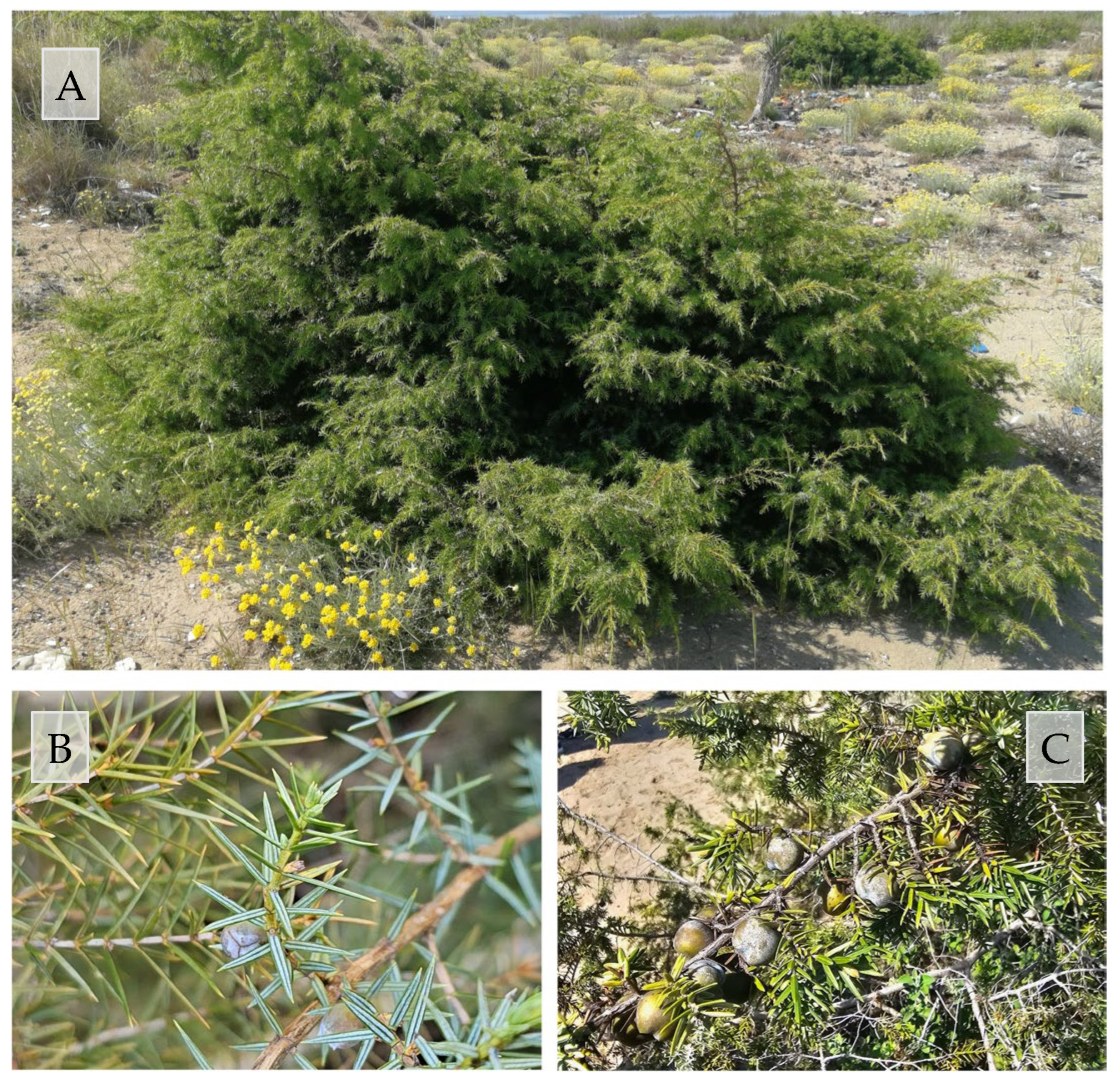
Juniperus macrocarpa Sm. (
Figure 1), belonging to the family Cupressaceae (order Pinales), is a diploid species with a chromosome number of 2n = 22. It is a long-lived, evergreen, dioecious conifer characterized by a shrubby habit reaching about 3 m in height, with a Euro-Mediterranean distribution [
2]. The species typically inhabits dunes and coastal sand flats and is also present, occasionally, in rocky areas.
From a biological perspective,
J. macrocarpa is a long-lived, slow-growing conifer characterized by delayed sexual maturity, irregular and generally low seed production, and recruitment occurring mainly through episodic pulses rather than continuous regeneration [
3,
4]. Seed production is strongly influenced by climatic conditions and exhibits marked interannual variability, while seed dispersal is primarily mediated by birds and small mammals, which play a major role in shaping the spatial and temporal patterns of recruitment [
5]. Germination and early seedling establishment are severely constrained by salinity, substrate instability, and summer drought typical of Mediterranean coastal environments; therefore, successful recruitment depends largely on the availability of favorable microsites, where partial substrate stabilization and reduced environmental stress facilitate seedling survival and early growth [
6,
7].
J. macrocarpa is a diagnostic, constant, and dominant species of EUNIS habitat N1B “Mediterranean and Black Sea coastal dune scrub spp.” [
8], corresponding to the priority habitat 2250 “Coastal dunes with
Juniperus spp.” of the EU Habitats Directive (92/43/EEC). This habitat, characterized by juniper-dominated scrub formations, represents the most mature stage of psammophilous succession on coastal sand dunes [
9].
Across the Mediterranean Basin,
J. macrocarpa occupies a range of coastal habitats, including embryonic dunes, fixed dunes, and stabilized inner dune systems. Its distribution and population dynamics are strongly influenced by geomorphological processes, disturbance regimes, and human pressures. In several Mediterranean regions, including southern Spain, Sardinia, Sicily, Corsica, and other central Mediterranean coasts, populations are frequently reported as fragmented, with limited recruitment and high sensitivity to both natural disturbances (storm surges, erosion, prolonged drought) and anthropogenic impacts such as coastal development, tourism infrastructure, and trampling [
4,
10].
However, although Italy hosts the main area of this habitat at the EU level followed by Spain and France [
11], the distribution in Italy of
J. macrocarpa is highly discontinuous, with large habitat remnants mainly confined to Sardinia, Tuscany, Latium, and Apulia [
12].
In Tuscany, habitat N1B is formally identified within the various protected areas that are part of the Natura 2000 network [
13], for a total coastal development of about 50 km.
Although phytocoenoses of
J. macrocarpa are still distributed in almost all the sandy coasts of the region, numerous critical factors such as access to the sea, bathing establishments, summer sports facilities, roads, ports, and coastal erosion severely limit their diffusion [
14,
15,
16,
17]. Within the N1B habitat,
J. macrocarpa is normally widely distributed in the innermost belt of the consolidated dune. Furthermore, it colonizes stabilized coastal dune grasslands (N16 EUNIS habitat) up to the edge of the mobile dunes with
Ammophila arenaria (N13 EUNIS habitat) [
2,
8,
18]. Along the Tuscan coast, this distribution dynamic is present in almost all the coastal sectors [
19,
20,
21,
22,
23,
24,
25].
Despite the extensive literature describing the ecology and conservation status of
Juniperus macrocarpa, important knowledge gaps remain regarding its long-term population dynamics and the mechanisms driving its contrasting trends across Mediterranean coasts. In particular, few studies have provided quantitative, spatially explicit assessments of decadal-scale changes in both population structure and spatial organization of this species within coastal dune systems. Moreover, the apparent expansion of
J. macrocarpa observed along parts of the Tuscan coast contrasts sharply with the widespread decline reported for most Mediterranean regions, and the ecological and geomorphological drivers of this divergence remain poorly understood [
4,
10]. This lack of integrative, site-comparative analyses currently limits the ability to predict future trajectories of this priority habitat under changing environmental and management conditions.
Recently, a notable expansion of the species has been documented in two coastal sites located north of the Arno River (Migliarino–San Rossore–Massaciuccoli Regional Park, Tuscany, Italy) [
26]. This trend contrasts with the southern sectors of the park, where habitat N1B has undergone severe regression and fragmentation due to coastal erosion [
15,
27,
28].
The present study aims to characterize the spatial distribution and recent dynamics of Juniperus macrocarpa populations along this sector of the coast by comparing two discrete time points (2013 and 2023), thereby allowing the assessment of decadal-scale changes in population structure, spatial organization, and dune system dynamics.
In particular, the extent and spatial patterns of J. macrocarpa expansion were quantified across the dune system with reference to the main vegetation belts that typify Mediterranean psammophilous zonation.
This approach was implemented through integrated field monitoring and the analysis of high-resolution satellite imagery (2013) and UAV-based orthophotos (2023).
Current approaches to vegetation mapping increasingly rely on the combined use of field surveys and remote sensing techniques, with a growing application of UAV platforms [
29,
30,
31]. The use of UAV technology, providing low-altitude and very high-resolution imagery, allows not only the identification and mapping of phytocoenoses but also the detection of plant species at the individual level [
32,
33,
34].
By integrating remote sensing analyses with detailed ground-based surveys, robust estimates of plant cover, individual density, and spatial organization along the sea–inland gradient were obtained. Beyond a purely descriptive assessment, this approach also supports an ecological interpretation of the observed distribution patterns, allowing evaluation of whether the current expansion of J. macrocarpa reflects natural successional dynamics and enhanced stabilization of dune systems.
From this perspective, the results of this study contribute to a better understanding of the functioning and evolution of Mediterranean coastal dune ecosystems and provide a spatially explicit baseline to support long-term monitoring, conservation planning, and adaptive management strategies for priority habitat N1B.
2. Materials and Methods
2.1. Study Area
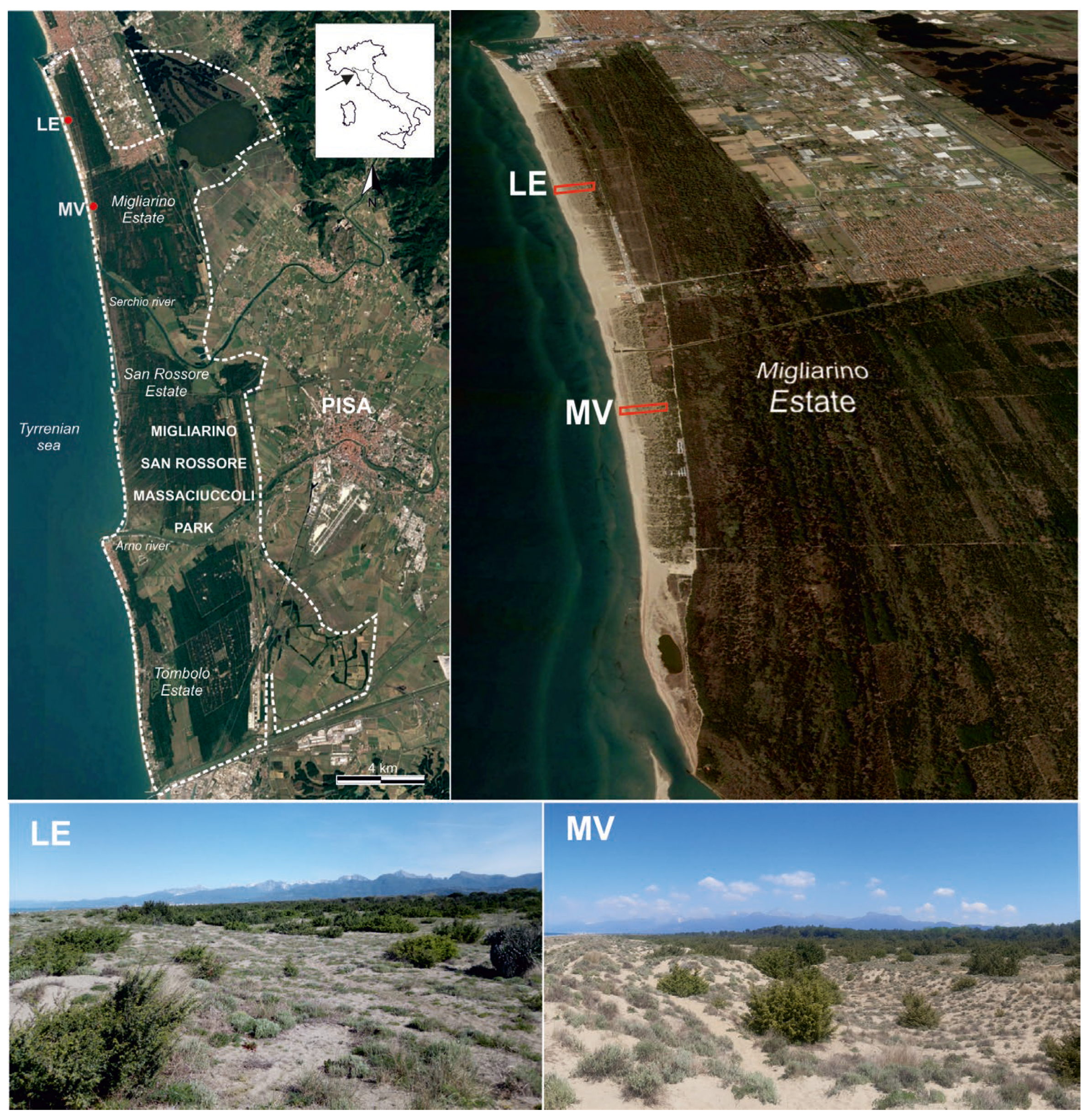
The investigated areas are part of the coast of the Migliarino San Rossore Massaciuccoli Park (Tuscany, Italy) (between 43°51′36″–43°35′25″ N and 10°14′26″–10°21′11″ E) (
Figure 2). In 2004, the park was designated by UNESCO a Biosphere Reserve [
35].
Although accounting for only a small fraction of the park area (1.7% of the total), the dune system represents an environment of high ecological value in terms of coastal habitat diversity [
27]. In particular, the study area is located in the northern sector of the park (Tenuta di Migliarino), comprising about 8 km of coast subject to protective restrictions but freely accessible to the public. Since the 1950s, the coastline has progressed steadily until it stabilized in 2019. On the contrary, the southern sector of the park is under an imposing erosive process (Tenuta di San Rossore) [
36] or partly transformed by bathing establishments (Tenuta di Tombolo) [
28].
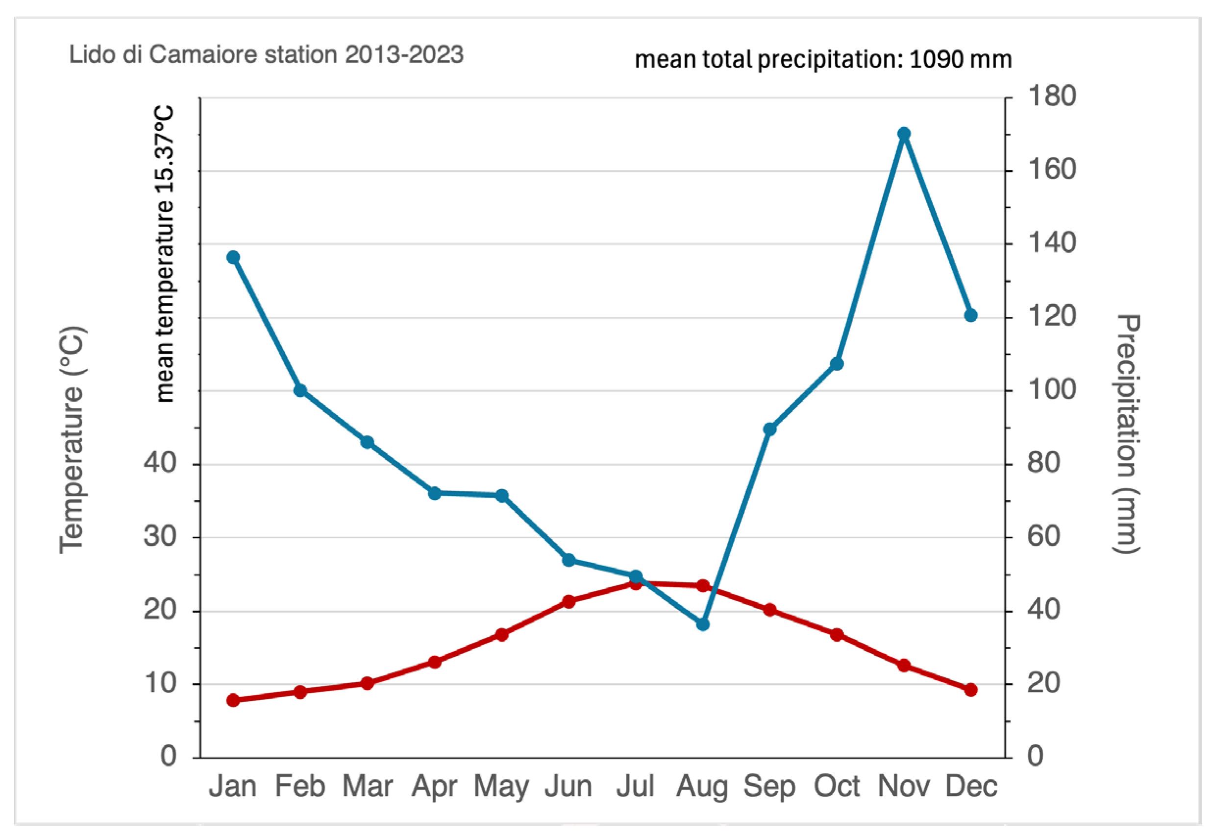
To characterize the local climate, temperature and precipitation data for the 2013–2023 interval were obtained from the weather station of Lido di Camaiore (Lucca, Tuscany; SIR code TOS11000011; 43.898° N, 10.243° E), located approximately 7–11 km north of the study sites [
37].
The study area shows a mean annual temperature of 15.4 °C, with thermal peaks occurring in July (mean monthly maximum: 23.8 °C). The annual average rainfall for the investigated decade was 1090 mm, with a peak recorded in November (170 mm).
According to the Walter–Lieth diagram (
Figure 3), the area exhibits a typical Mediterranean seasonality with a distinct period of summer drought. While strictly defined aridity (P < 2T) is most pronounced in August, water shortages frequently extend from June to September due to high evaporation rates and irregular rainfall patterns.
Indeed, beyond average values, the precipitation regime is characterized by pronounced temporal irregularity. During the summer quarter (June–August), the mean frequency of rainfall events is extremely low, averaging only 4.0, 2.9, and 3.5 rainy days per month, respectively. These long sequences of consecutive rainless days, combined with high summer temperatures and strong coastal winds, generate severe water stress for dune vegetation during the critical growing season.
Interannual variability further amplifies these constraints, producing alternating years of severe water deficit and short periods of higher moisture availability.
According to the bioclimatic classification of Pesaresi et al. [
38], the study area falls within the Mediterranean macrobioclimate, with an upper meso-Mediterranean thermotype and a lower subhumid ombrotype. This climatic framework defines a highly selective environment for coastal dune vegetation, where plant recruitment and survival are strongly controlled by the interaction between episodic rainfall pulses and prolonged summer drought.
2.2. Remote Sensing and GIS
Along this stretch of coast, two rectangular areas orthogonal to the coastline have been selected: Lecciona (LE: 43.831205° N, 10.252566° E) and Marina di Vecchiano (MV: 43.804642° N, 10.263243° E) (
Figure 2).
This choice was based on the extent of N1B habitat and the consistency of the dune environment. The two areas have a width of 80 m and comparable depths (282 m for Lecciona, 315 m for Marina di Vecchiano). The inner edge was represented by the substitution of N1B habitat with strict woodlands habitats.
The investigation was designed as a diachronic study comparing the spatial structure and population dynamics of J. macrocarpa in the years 2013 and 2023.
Two different orthophoto datasets were used to construct the experimental design and perform spatial analyses and processed in a GIS environment (QGIS v.3.4) [
39]. The first is a regional aerial survey from October 2013 [
40] with a resolution of 20 cm/pixel. The second was acquired in May 2023 using a DJI Mini 3 Pro drone (SZ DJI Technology Co., Ltd., Shenzhen, China).
The UAV was equipped with a standard RGB camera (1/1.3-inch sensor, 24 mm equivalent focal length, f/1.7 aperture, FOV 82.1°, SZ DJI Technology Co., Ltd., Shenzhen, China) capturing 48 MP images (4032 × 3024 pixels). Flight parameters included a shutter speed of 1/1600 s and ISO 110. A total of 185 and 236 nadir images were collected for Lecciona and Marina di Vecchiano, respectively, at a flight altitude of 25 m AGL and a speed of 2.5 m/s (forward overlap: 60%; side overlap: 80%). This resulted in a Ground Sampling Distance (GSD) of approximately 0.5 cm/pixel.
An orthomosiac was performed using the Agisoft Metashape 17.5, achieving an RMSE (root mean square error) reprojection of 0.29 pixels.
The orthomosaic data from 2013 were georeferenced in WGS 84/UTM zone 32N (EPSG: 32632). In the QGIS environment, UAV images were automatically overlaid on orthomosaic 2013. The observed average shift between datasets was approximately 20 cm. This alignment error was considered negligible for the identification and positioning of J. macrocarpa individuals.
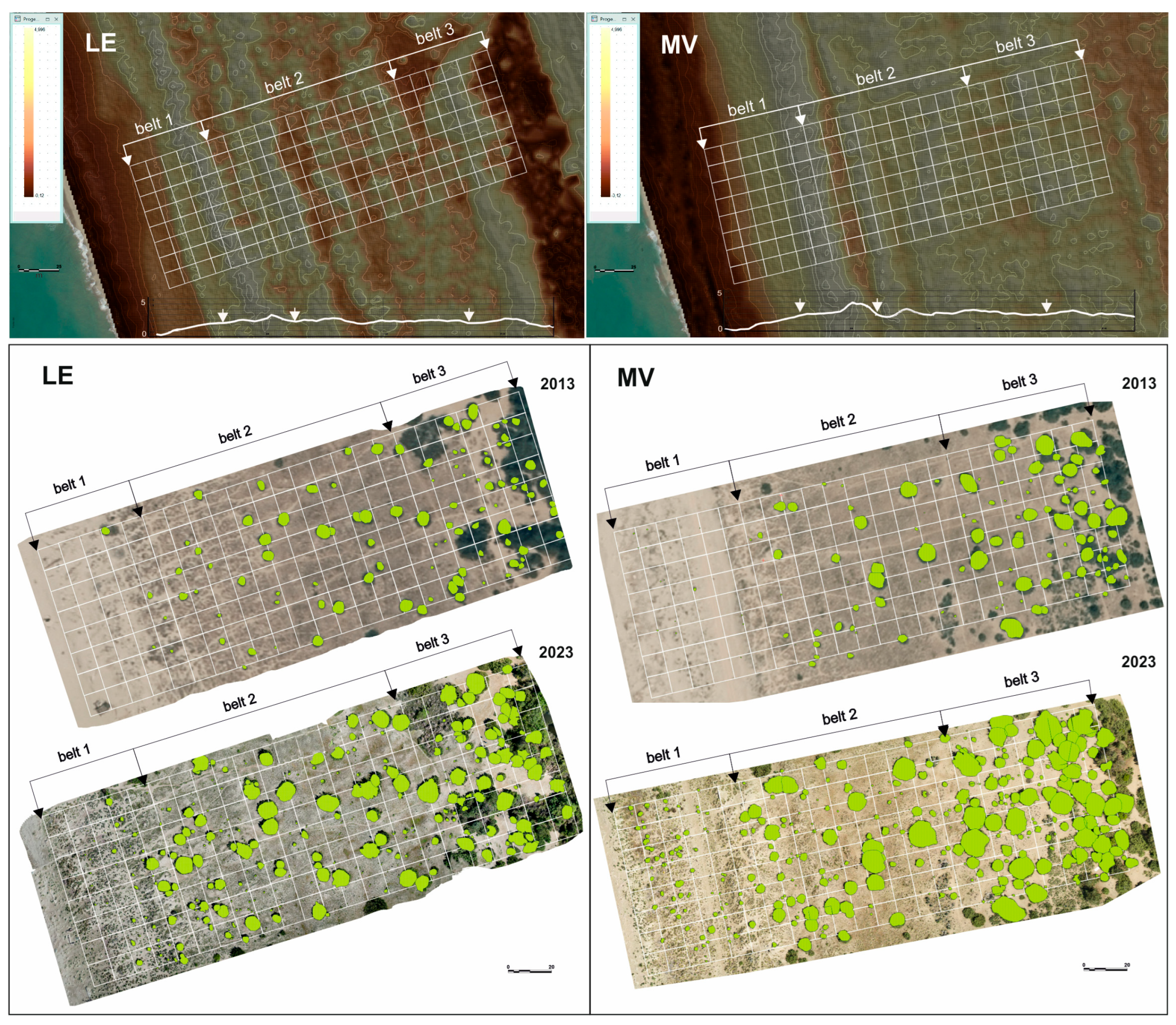
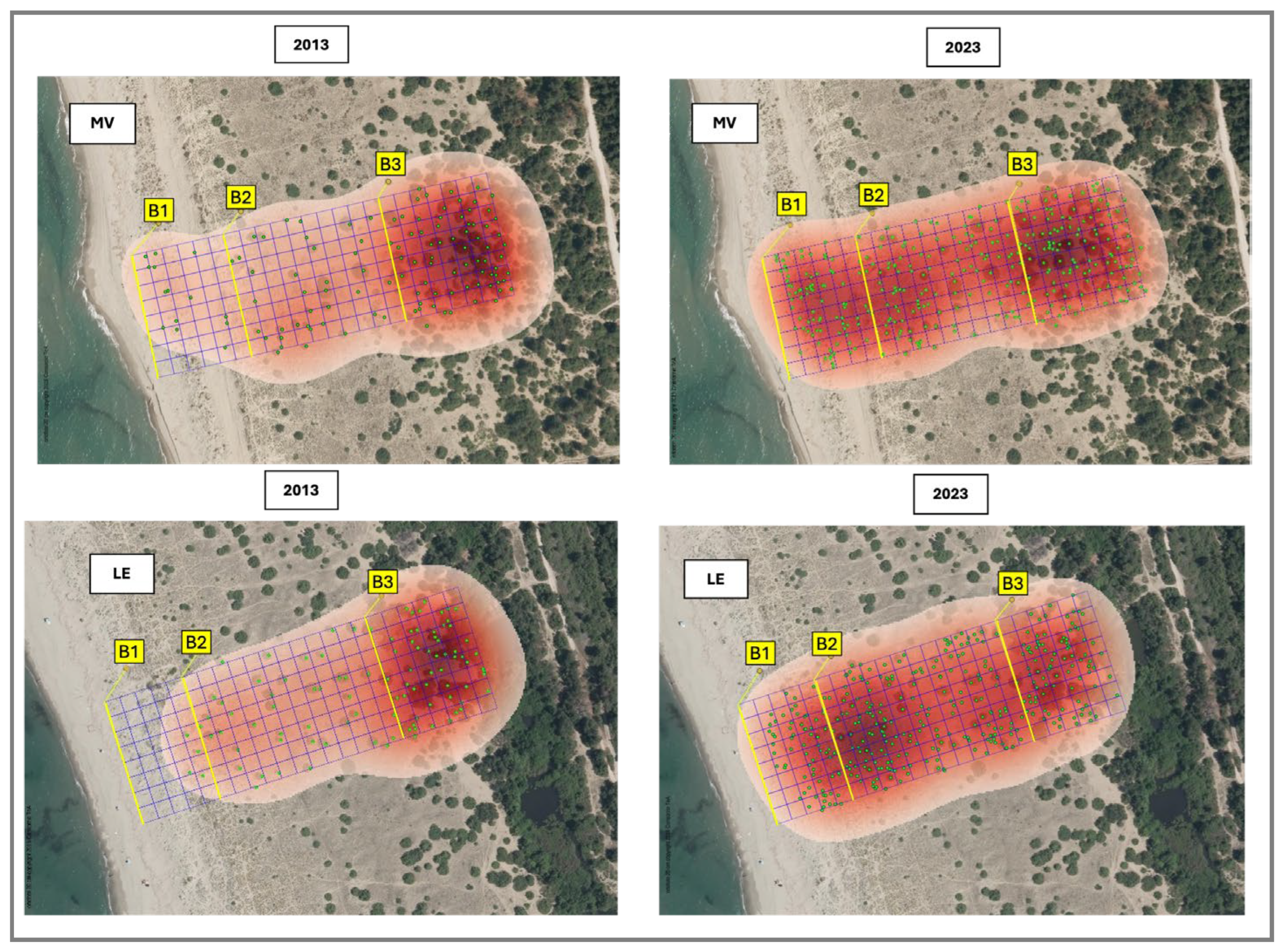
A 10 × 10 m grid was overlaid on each study area, dividing it in three dune belts: B1 (drift lines and shifting dunes, EUNIS N12–N14), B2 (consolidated grassland dunes, EUNIS N16), and B3 (coastal dune scrub, EUNIS N1B). A total of 184 plots were analyzed per site. However, the distribution among bands varied due to the different habitat depths: Lecciona comprised 40 plots in B1, 96 in B2, and 48 in B3, while Marina di Vecchiano included 48 plots in B1, 80 in B2, and 56 in B3. This difference in the number of plots was due to the different depths of the habitats in the two areas (
Figure 4).
Finally, the crowns of J. macrocarpa individuals were identified through manual photointerpretation and subsequently traced by GIS vector tools, considering all individuals wholly or partially within the plots with a minimum diameter of 30 cm (a threshold dictated by the lower resolution of the 2013 dataset).
Field surveys were subsequently carried out to validate the accuracy of photointerpretation and identification of the investigated species.
Kernel density estimation (KDE) was applied to georeferenced
J. macrocarpa occurrence data to generate continuous density surfaces describing spatial patterns across the dune system. Using a Gaussian kernel function, KDE allowed the identification of density gradients and aggregation zones along the sea–inland transect. Bandwidth selection was optimized to capture spatial structure while minimizing noise. Density surfaces were normalized to compare distribution patterns between survey years and among dune vegetation belts [
41].
2.3. Statistica Analysis
J. macrocarpa population data were analyzed using univariate analyses of variance (ANOVA), with the number of individuals, coverage area per plot, and coverage area per individual as dependent variables, and year (2013, 2023), belt (B1, B2, B3), and site (Lecciona, Marina di Vecchiano) as fixed factors. The assumption of homogeneity of variances was tested using Levene’s test. When this assumption was not met, Tamhane’s T2 post hoc test was applied for multiple comparisons. All statistical analyses were performed using SPSS Statistics 26.0 (IBM Corp., Armonk, NY, USA).
4. Discussion
This study documents a pronounced expansion of J. macrocarpa within the analyzed coastal dune systems, characterized by substantial increases in abundance, cover, and spatial extent. In contrast to the widespread decline reported for Mediterranean dunes, the observed patterns highlight a rapid colonization of shifting dune belts and a progressive shift toward a more homogeneous distribution across the dune profile.
The distribution of
J. macrocarpa along the sea–inland gradient reflects the strong influence of abiotic constraints in structuring Mediterranean dune vegetation, operating in close interaction with biotic processes, including species interactions and facilitation mechanisms [
7].
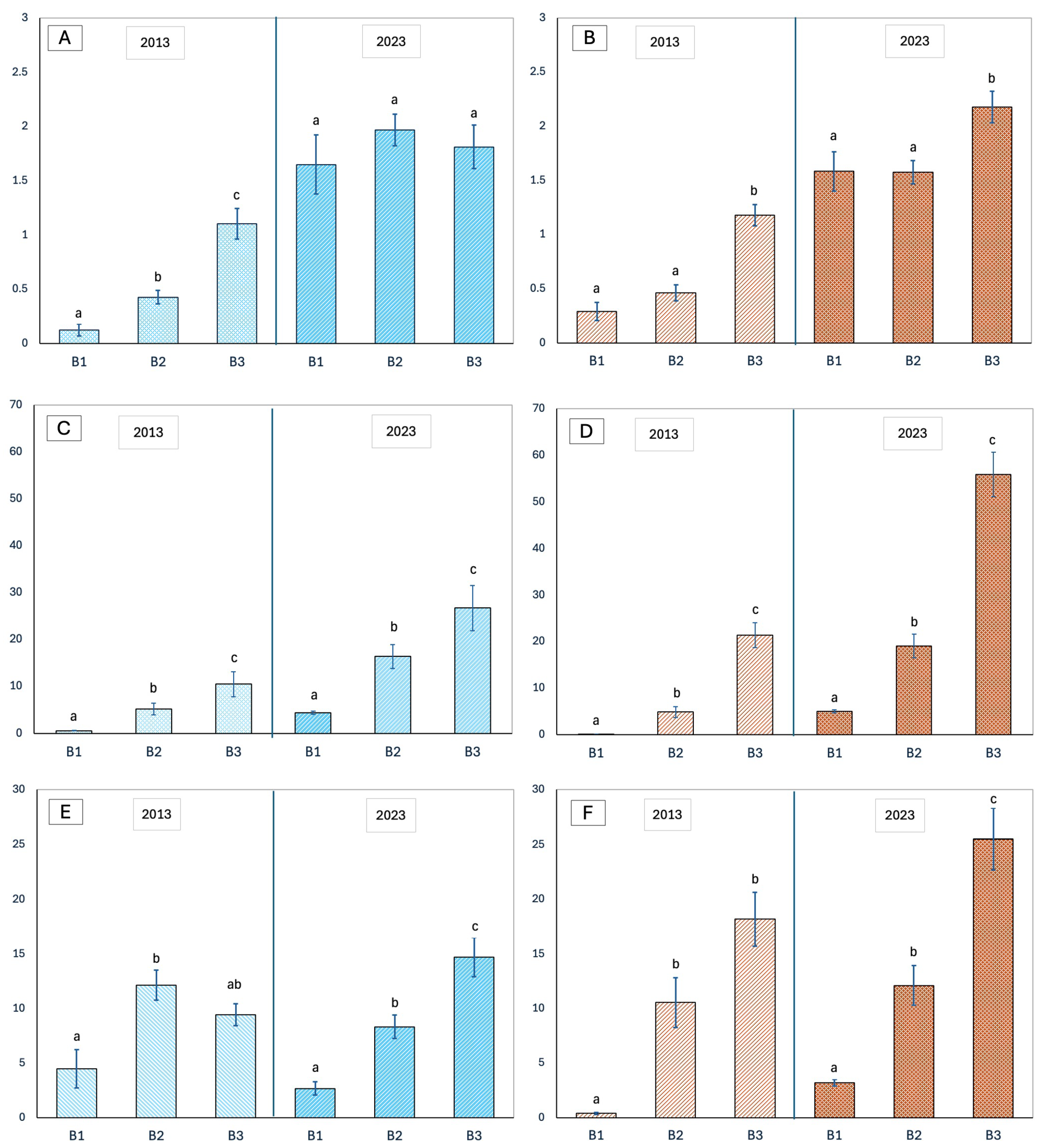
Pronounced differences in the
J. macrocarpa abundance were observed among belts across both sites and years, with B3 generally supporting the highest values, whereas patterns of mean individual size varied by site and year along the landward–seaward gradient [
1]. Consistent with findings from other Mediterranean coastal systems [
2,
10],
J. macrocarpa reaches its ecological optimum in the inner dune belt (B3). This belt, characterized by greater substrate stability and water availability, traditionally supports the highest density of large, established individuals. Conversely, in accordance with the Stress Gradient Hypothesis [
42], the seaward belt (B1) represents a physiological threshold, where intense salt spray, wind exposure, burial, and abrasion impose strong constraints on adult growth and survival, while potentially enhancing the relative importance of facilitative interactions during early life stages.
The comparison between J. macrocarpa populations in 2013 and 2023 revealed a significant overall increase in the number of individuals across all belts and at both sites, particularly in B1.
However, changes in abundance were not always accompanied by proportional changes in individual size or total cover, indicating a partial decoupling between demographic expansion and structural development of the shrub layer.
While overall cover provides an integrated measure of population expansion and habitat occupation, additional information on individual canopy size and fine-scale spatial arrangement would further improve the interpretation of population structure and dispersal dynamics. Nevertheless, the strong and consistent increase in cover observed across belts and years clearly documents a major expansion of J. macrocarpa within the dune system.
Although plot-based metrics provide a robust measure of macro-scale demographic expansion, the discrepancy between density and cover highlights the need for finer-scale spatial analysis. Future studies incorporating nearest-neighbor analyses could further elucidate the specific facilitative interactions that are likely enabling this colonization in high-stress zones. Despite the environmental severity of the foredune, the observed pattern suggests two complementary ecological drivers. First, density-dependent regulation appears to limit further expansion in the inner dune belt (B3); here, large adult individuals occupy extensive areas (up to ~25 m
2), generating strong competition for light and space that limits seedling establishment (self-thinning). Second, microsite availability in the shifting dune belts (B1 and B2) drives the current expansion; the open and discontinuous vegetation structure provides abundant gaps where reduced intraspecific competition facilitates seed germination and early survival [
43], effectively channeling the recent mass recruitment event toward the sea.
Consequently, the marked increase in abundance in B1 in 2023 represents a clear colonization event rather than a regenerative phase. Unlike the inner belts, where recruitment is often driven by gap formation following adult mortality, the expansion in B1 was likely promoted by the high availability of open, competition-free microsites. This condition allowed the establishment of pioneer individuals despite the harsh environmental conditions, consistent with the episodic recruitment pulses typical of long-lived species in shifting dune systems [
5,
6]. The absence of a significant concomitant temporal increase in mean individual cover further supports the interpretation that populations in B1 are dominated by young or subadult individuals that have not yet contributed substantially to biomass accumulation.
Collectively, data from the two study sites indicate positive demographic trajectories, unlike much of the rest of the sandy coasts of Tuscany [
15,
19,
25] and, more generally, of the Mediterranean area, where
J. macrocarpa is often reported as vulnerable [
4,
10]. This pattern is likely related not only to the low level of human disturbance but also to the long-term progradation of the coastline and the specific geomorphological configuration of this sector of dune systems. Here, dunes are characterized by a low-relief and weakly articulated morphology, resulting in broad and relatively uniform surfaces that favor progressive colonization and stabilization.
The significant Site × Belt interaction both for J. macrocarpa plant density, and cover per plot, reveals distinct ecological dynamics at the two dune systems, suggesting important site-specific differences that cannot be fully explained by a simple sea–inland successional model.
At Lecciona, large individuals were mainly concentrated in belt B2 in 2013 and maintained a similar spatial configuration in 2023, suggesting a relatively homogeneous and already stabilized system across much of the gradient.
In contrast, at Marina di Vecchiano, the spatial distribution of individual size follows a more orderly and pronounced sea–inland gradient, with larger and more developed shrubs increasingly concentrated in the inner dune belt (B3). This pattern is consistent with a classical successional trajectory of Mediterranean dune systems, in which structural maturity and biomass accumulation progressively increase from the foredune toward the stabilized inner dune.
These contrasting patterns suggest that present-day population structure is not controlled solely by current environmental gradients, but is strongly shaped by the geomorphological history of each site and by processes of historical contingency, which collectively determine long-term dune stabilization and vegetation dynamics.
At Marina di Vecchiano, the simultaneous increase in abundance and size of individuals reflects a structurally coherent trend of dune stabilization or progradation.
At Lecciona, the pronounced decoupling between increasing density and decreasing individual size in the B1 belt likely reflects a recent phase of colonization, although the influence of episodic disturbance cannot be excluded. Indeed, although erosion is absent at both sites—a rare feature along Mediterranean coasts—the foredune remains highly exposed to mechanical stress caused by storm surges, salt spray, and strong winds, all factors known to induce canopy regression in coastal juniper stands [
37,
44].
The resulting creation of colonizable gaps likely activated the seed bank and promoted the massive recruitment observed in 2023. This mechanism aligns with the well-documented disturbance–recovery dynamics typical of shrub species in variable dune environments [
6].
In both sites, the inner dune belt (B3) emerges as the primary resilience reservoir of the dune system. Large individuals within this belt maintain structural continuity, accumulate substantial biomass, and ensure long-term propagule production. The increase in mean individual size observed between 2013 and 2023 suggests that the carrying capacity for
J. macrocarpa in the inner dune has not yet been reached, thereby allowing further densification and structural consolidation of the shrub layer. Similar dynamics have been reported in other Mediterranean shrub communities undergoing late-successional consolidation [
45].
Accordingly, the inner dune fulfills a dual ecological function: (i) it acts as a key structural stabilizer of the system, and (ii) it serves as a propagule source facilitating the recolonizing of more vulnerable outer dune belts.
The decade-long trends observed here allow cautious predictions of future system dynamics. A key feature distinguishing these sites from many Mediterranean dune systems is the absence of active coastline erosion, a condition that may enhance long-term vegetation stability and promote the continued expansion of J. macrocarpa towards the outer dune belts.
Under scenarios of reduced anthropogenic pressure, geomorphological stability, and adequate sediment supply, B1 and B2 belts are expected to undergo further
J. macrocarpa population densification. At Lecciona, where the zonation gradient is already weakened, this process may lead to a progressive reduction in habitat heterogeneity, with increasing dominance of
J. macrocarpa and a consequent loss of distinct zonation between early- and late-successional dune belts. At Marina di Vecchiano, future dynamics are more likely to involve the coalescence of shrub nuclei within the B2–B3 belts, resulting in increasingly continuous juniper stands. Nevertheless, even in the absence of chronic erosion, rising climatic variability—including extreme storm events, intensified wind regimes, and prolonged drought—may induce episodic mortality and trigger disturbance–recovery cycles, as widely reported for Mediterranean dunes ecosystems [
46,
47].
Overall, in the absence of active management, J. macrocarpa is expected to continue its spatial expansion, reinforcing dune stabilization but potentially constraining early-successional open habitats. Long-term monitoring, coupled with scenario-based management strategies, will therefore be crucial to balance conservation objectives with ongoing natural successional dynamics.
5. Conclusions
Overall, the results of this study demonstrate that J. macrocarpa populations in both investigated sites are in good demographic condition and are undergoing a marked phase of spatial expansion. However, the observed dynamics are not uniform across sites and reflect the combined influence of geomorphological history, local disturbance regimes, and current environmental constraints.
At Marina di Vecchiano, J. macrocarpa population growth follows a coherent successional trajectory, with increasing abundance and canopy development converging toward the inner dune belt (B3), consistent with progressive dune stabilization and limited recent disturbance. At Lecciona, the population exhibits a more homogeneous spatial structure along the sea–inland gradient, shaped by earlier stabilization processes and by the legacy of past geomorphological conditions. This has resulted in site-specific internal organization and a partial decoupling between density and individual size, particularly in the foredune belt.
The pronounced expansion of J. macrocarpa observed along this stretch of Tuscan coast appears to be driven by a unique combination of favorable factors, including long-term geomorphological stability, the absence of chronic shoreline erosion, reduced anthropogenic pressure within protected areas, and a climatic regime characterized by strong inter-annual variability and episodic stress. Together, these conditions promote both adult persistence and repeated recruitment pulse, allowing the species to progressively colonize seaward dune sectors. This combination of drivers helps explain why similar expansion patterns are not consistently observed in many other European coastal regions, where J. macrocarpa occurs but remains more fragmented or demographically constrained due to stronger erosion, higher human pressure, or less favorable disturbance regimes.
From a conservation perspective, these findings provide concrete guidance for the management of Mediterranean coastal dune ecosystems. The identification of site-specific demographic trajectories highlights the need for locally adapted conservation strategies rather than uniform management prescriptions. In areas characterized by strong J. macrocarpa expansion and geomorphological stability, management actions should aim to preserve dune continuity while maintaining a mosaic of early- and late-successional habitats. Conversely, in sectors subject to erosion or higher anthropogenic pressure, conservation priorities should focus on protecting remnant juniper stands, enhancing natural regeneration processes, and limiting physical disturbance.
The spatial baseline provided here enables repeated UAV-based monitoring to track recruitment, canopy growth, and disturbance–recovery cycles, supporting early-warning detection of shifts in dune zonation under increasing climatic variability. Future work integrating individual-level spatial metrics (e.g., nearest-neighbor analyses) will refine mechanistic interpretations of facilitation and dispersal processes and improve adaptive management of habitat 2250/EUNIS N1B.