
Remote Sensing Vegetation Indices in Viticulture: A Critical Review


Abstract
1. Introduction
2. Publications and Research
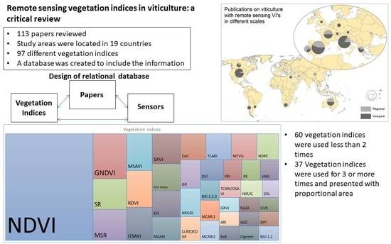
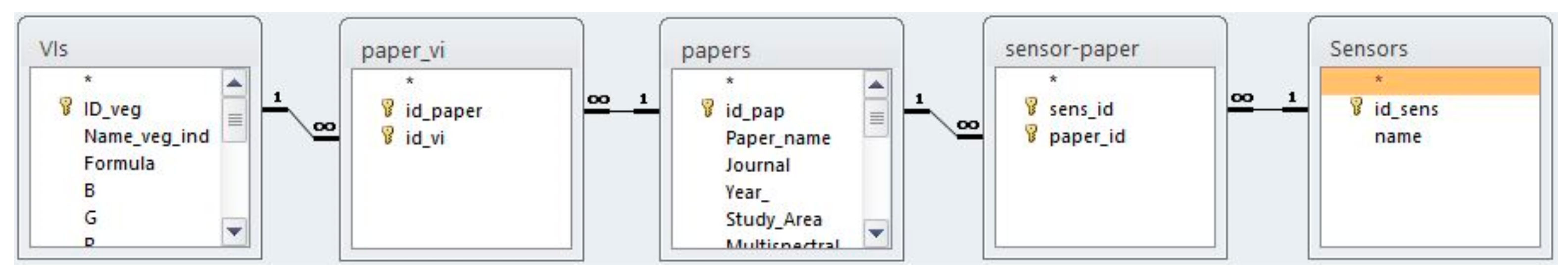
2.1. Review Methodology
2.2. Study Areas Spatial Distribution
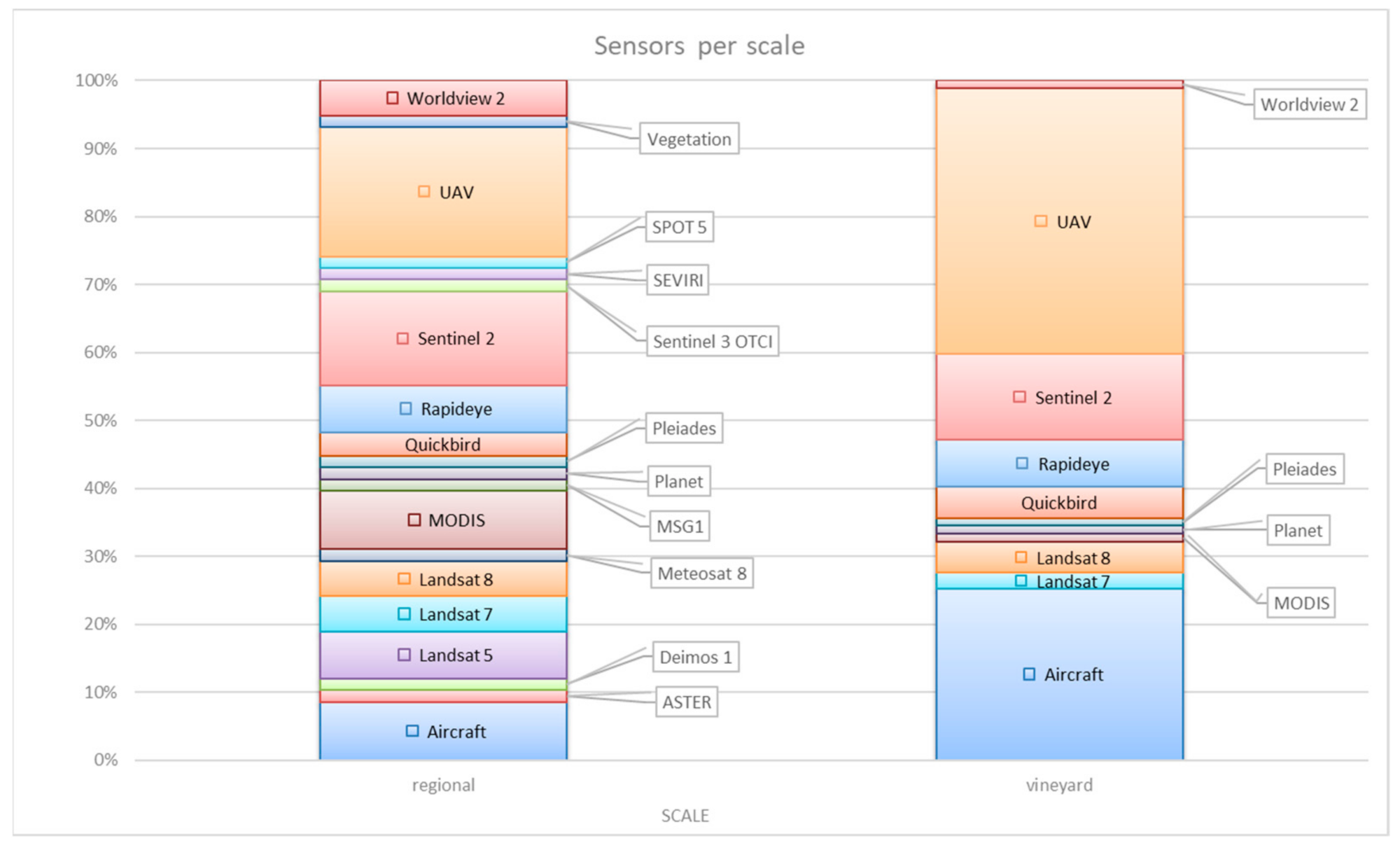
2.3. The Remote Sensing Platforms
3. Vegetation Indices
3.1. Vegetation Indices and Electromagnetic Spectrum
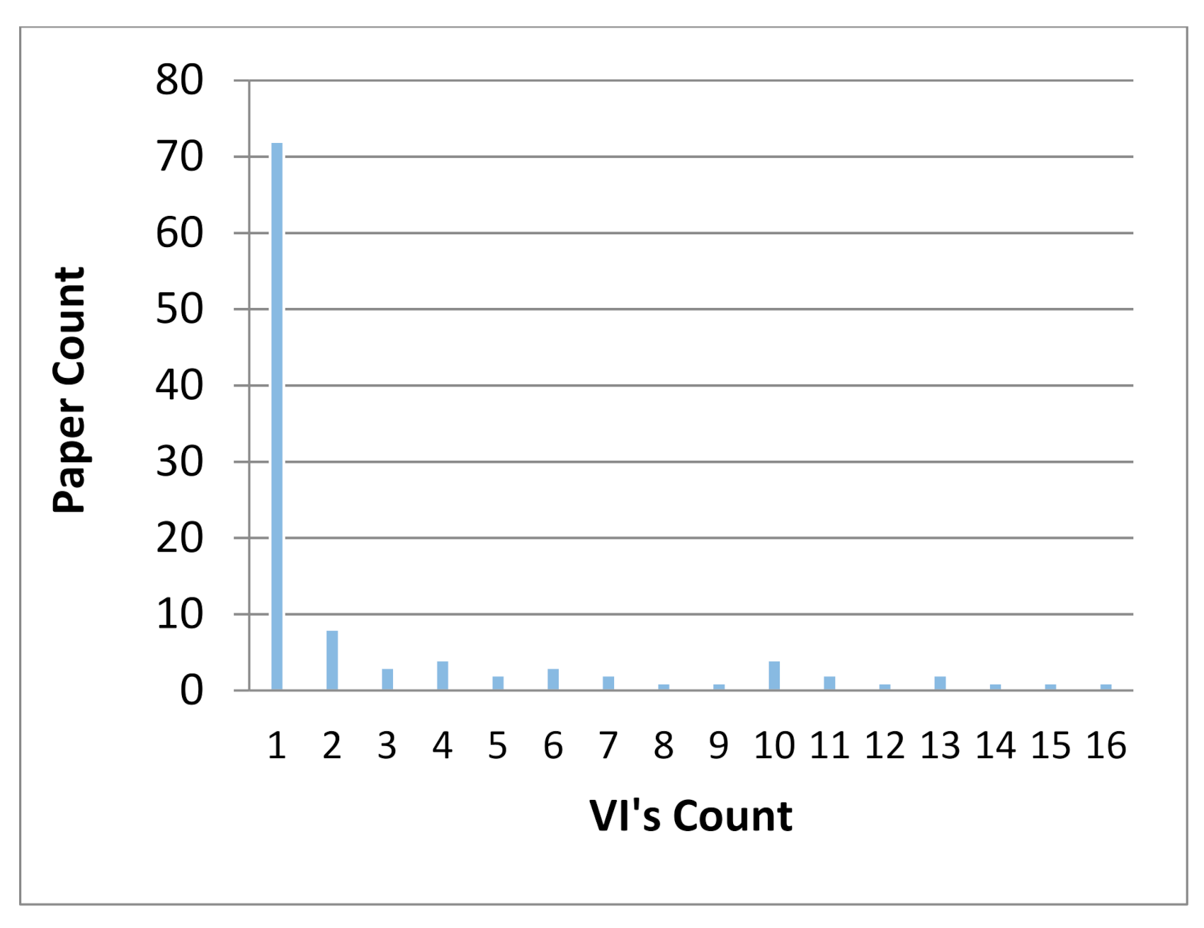
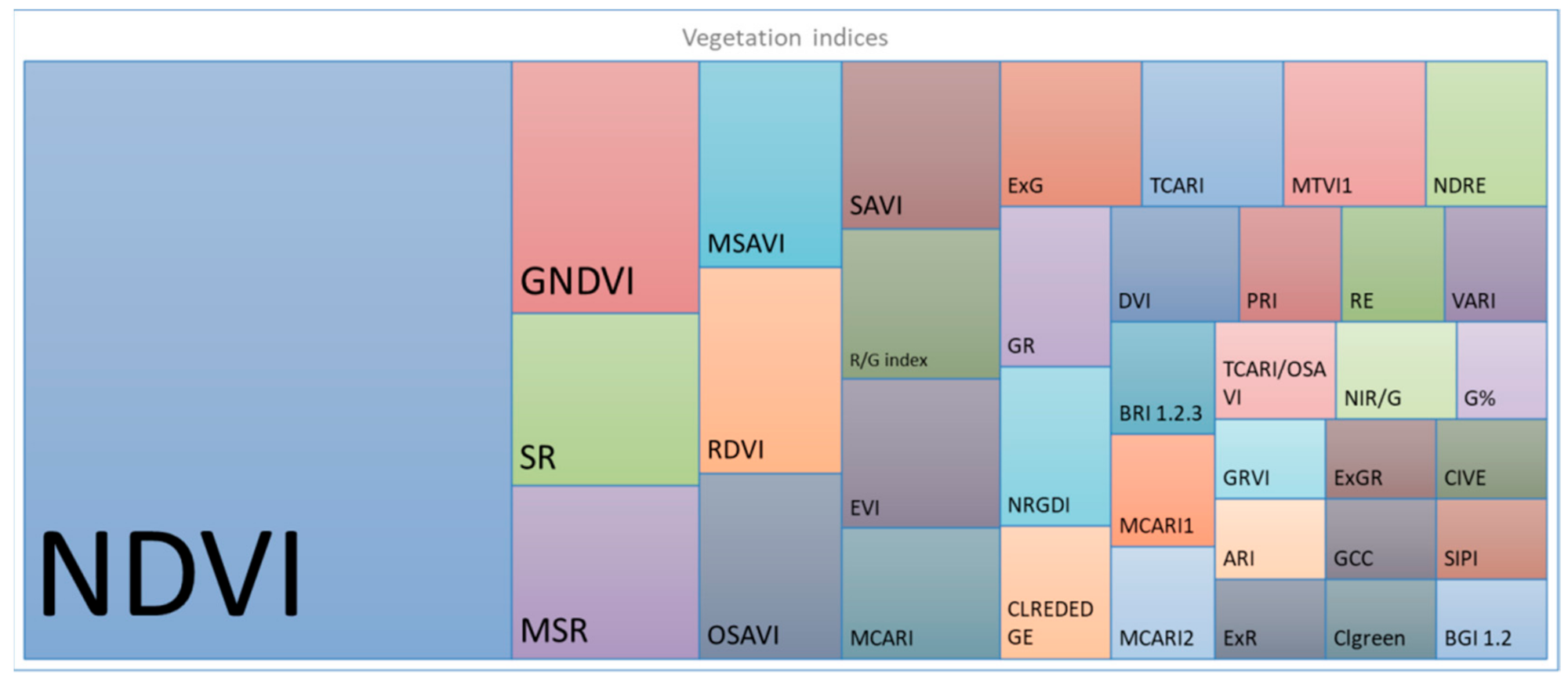
3.2. Review of VI’s in Viticulture Publications
4. Applications in Viticulture
4.1. Methodologies in Vine Research
4.2. Research Focus and Applications in Viticulture
5. Discussion and Future Perspectives
6. Conclusions
Author Contributions
Funding
Institutional Review Board Statement
Informed Consent Statement
Conflicts of Interest
References
- Lutz, H.F. Viticulture and Brewing in the Ancient Orient; G.E. Stechert: Leipzig, Germany, 1922. [Google Scholar] [CrossRef]
- Zhang, Q. Precision Agriculture Technology for Crop Farming; CRC Press: Washington, DC, USA, 2016; ISBN 13: 978-1-4822-5108-1. [Google Scholar]
- Arnó, J.; Martínez-Casasnovas, J.A.; Ribes-Dasi, M.; Rosell, J.R. Review. Precision Viticulture. Research topics, challenges and opportunities in site-specific vineyard management. Span. J. Agric. Res. 2009, 7, 779–790. [Google Scholar] [CrossRef]
- Caruso, G.; Tozzini, L.; Rall, G.; Primicerio, J.; Moriondo, M.; Palai, G.; Gucci, R. Estimating biophysical and geometrical parameters of grapevine canopies(‘Sangiovese’) by an unmanned aerial vehicle (UAV) and VIS-NIR cameras. Pisa. Vitis 2017, 56, 63–70. [Google Scholar] [CrossRef]
- Gil-Perez, B.; Zarco-Tejada, P.J.; Correa-Guimaraes, A.; Relea-Gangas, E.; Navas-Gracia, L.M.; Hernadez-Navarro, S.; Sans-Requena, J.F.; Berjon, A.; Martin-Gil, J. Remote sensing detection of nutrient uptake in vineyards using narrow-band hyperspectral imagery. Valladolid. Vitis 2010, 49, 167–173. [Google Scholar]
- Romero, M.; Luo, Y.; Su, B.; Fuentes, S. Vineyard water status estimation using multispectral imagery from an UAV platform and machine learning algorithms for irrigation scheduling management. Comput. Electron. Agric. 2018, 147, 109–117. [Google Scholar] [CrossRef]
- Soubry, I.; Patias, P.; Tsioukas, V. Monitoring vineyards with UAV and multi-sensors for the assessment of water stress and grape maturity. J. Unmanned Veh. Syst. 2017, 5, 37–50. [Google Scholar] [CrossRef]
- Pôças, I.; Rodrigues, A.; Gonçalves, S.; Costa, M.P.; Gonçalves, I.; Pereira, S.L.; Cunha, M. Predicting Grapevine Water Status Based on Hyperspectral Reflectance Vegetation Indices. Remote Sens. 2015, 7, 16460–16479. [Google Scholar] [CrossRef]
- Santesteban, L.G.; Guillaume, S.; Royo, J.B.; Tisseyre, B. Are precision agriculture tools and methods relevant at the whole-vineyard scale? Precis. Agric. 2013, 14, 2–17. [Google Scholar] [CrossRef]
- Ferrer, M.; Echeverría, G.; Pereyra, G.; Gonzalez-Neves, G.; Pan, D.; Manuel Mirás-Avalos, J. Mapping vineyard vigor using airborne remote sensing: Relations with yield, berry composition and sanitary status under humid climate conditions. Precis. Agric. 2020, 21, 178–197. [Google Scholar] [CrossRef]
- Xie, C.; Yang, C. A review on plant high-throughput phenotyping traits using UAV-based sensors. Comput. Electron. Agric. 2020, 178, 105731. [Google Scholar] [CrossRef]
- Hall, A. Remote sensing applications in viticulture: Recent advances and new opportunities. In Proceedings of the XI International Terroir Congress, McMinnville, OR, USA, 10–14 July 2016; pp. 358–363. [Google Scholar]
- Shafi, U.; Mumtaz, R.; García-Nieto, J.; Ali Hassan, S.; Ali Raza Zaidi, S.; Iqbal, N. Precision Agriculture Techniques and Practices: From Considerations to Applications. Sensors 2019, 19, 3796. [Google Scholar] [CrossRef]
- Hall, A.; Lamb, D.W.; Holzapfel, B.; Louis, J. Optical remote sensing applications in viticulture—A review. Aust. J. Grape Wine Res. 2002, 8, 36–47. [Google Scholar] [CrossRef]
- Xue, J.; Su, B. Significant Remote Sensing Vegetation Indices: A Review of Developments and Applications. J. Sens. 2017. [Google Scholar] [CrossRef]
- Hatfield, L.J.; Prueger, H.J.; Sauer, J.T.; Dold, C.; O’Brien, P.; Wacha, K. Applications of Vegetative Indices from Remote Sensing to Agriculture: Past and Future. Inventions 2019, 4, 71. [Google Scholar] [CrossRef]
- Adamides, G. A Review of Climate-Smart Agriculture Applications in Cyprus. Atmosphere 2020, 11, 898. [Google Scholar] [CrossRef]
- Sozzi, M.; Kayad, A.; Marinello, F.; Taylor, A.J.; Tisseyre, B. Comparing vineyard imagery acquired from Sentinel-2 and Unmanned Aerial Vehicle (UAV) platform. OENO One 2020, 189–197. [Google Scholar] [CrossRef]
- Di Gennaro, S.F.; Dainelli, R.; Palliotti, A.; Toscano, P.; Matese, A. Sentinel-2 Validation for Spatial Variability Assessment in Overhead Trellis System Viticulture Versus UAV and Agronomic Data. Remote Sens. 2019, 11, 2573. [Google Scholar] [CrossRef]
- Birth, S.G.; McVey, R.G. Measuring the Color of Growing Turf with a Reflectance Spectrophotometer. Agron. J. 1968, 60, 640–643. [Google Scholar] [CrossRef]
- Rouse, W.J.; Haas, H.R.; Schell, A.J.; Deering, W.D. Monitoring vegetation systems in the Great Plains with ERTS. In Third ERTS Symposium; NASA SP-351; NASA: Washington, DC, USA, 1973; Volume 1, pp. 309–317. [Google Scholar]
- Vanegas, F.; Bratanov, D.; Powell, K.; Weiss, J.; Gonzalez, F. A Novel Methodology for Improving Plant Pest Surveillance in Vineyards and Crops Using UAV-Based Hyperspectral and Spatial Data. Sensors 2018, 18, 260. [Google Scholar] [CrossRef]
- Brook, A.; de Micco, V.; Battipaglia, G.; Erbaggio, A.; Ludeno, G.; Catapano, I.; Bonfante, A. A smart multiple spatial and temporal resolution system to support precision agriculture from satellite images: Proof of concept on Aglianico vineyard. Remote Sens. Environ. 2020, 240, 111679. [Google Scholar] [CrossRef]
- Poblete, T.; Ortega-Farías, S.; Moreno, M.A.; Bardeen, M. Artificial Neural Network to Predict Vine Water Status Spatial Variability Using Multispectral Information Obtained from an Unmanned Aerial Vehicle (UAV). Sensors 2017, 17, 2488. [Google Scholar] [CrossRef]
- Cogato, A.; Pagay, V.; Marinello, F.; Meggio, F.; Grace, P.; de Antoni Migliorati, M. Assessing the Feasibility of Using Sentinel-2 Imagery to Quantify the Impact of Heatwaves on Irrigated Vineyards. Remote Sens. 2019, 11, 2869. [Google Scholar] [CrossRef]
- Jimenez-Brenes, F.M.; Lopez-Granados, F.; Torres-Sanchez, J.; Peña, J.M.; Ramırez, P.; Isabel Castillejo-Gonzalez, L.; de Castro, A. Automatic UAV-based detection of Cynodon dactylon for site-specific vineyard management. PLoS ONE 2019, 14, e218132. [Google Scholar] [CrossRef] [PubMed]
- Albetis, J.; Duthoit, S.; Guttler, F.; Jacquin, A.; Goulard, M.; Poilvé, H.; Féret, J.-B.; Dedieu, G. Detection of Flavescence dorée Grapevine Disease Using Unmanned Aerial Vehicle (UAV)Multispectral Imagery. Remote Sens. 2017, 9, 308. [Google Scholar] [CrossRef]
- Brunori, E.; Maesano, M.; Moresi, F.V.; Antolini, A.; Bellincontro, A.; Forniti, R.; Biasi, R.; Mencarelli, F. Using UAV-based remote sensing to assess grapevine canopy damage due to fire smoke. J. Sci. Food Agric. 2020, 100, 4531–4539. [Google Scholar] [CrossRef] [PubMed]
- Kerkech, M.; Hafiane, A.; Canals, R. Deep leaning approach with colorimetric spaces and vegetation indices for vine diseases detection in UAV images. Comput. Electron. Agric. 2018, 155, 237–243. [Google Scholar] [CrossRef]
- Ronchetti, G.; Mayer, A.; Facchi, A.; Ortuani, B.; Sona, G. Crop Row Detection through UAV Surveys to Optimize On-Farm Irrigation Management. Remote Sens. 2020, 12, 1967. [Google Scholar] [CrossRef]
- Sun, L.; Gao, F.; Anderson, C.M.; Kustas, P.W.; Alsina, M.M.; Sanchez, L.; Sams, B.; McKee, L.; Dulaney, W.; White, A.W.; et al. Daily Mapping of 30 m LAI and NDVI for Grape Yield Prediction in California Vineyards. Remote Sens. 2017, 9, 317. [Google Scholar] [CrossRef]
- Arango, R.B.; Camposy, A.M.; Combarro, E.F. Identification of Agricultural Management Zones Through Clustering Algorithms with Thermal and Multispectral Satellite Imagery. Int. J. Uncertain. Fuzziness Knowl. Based Syst. 2017, 25, 121–140. [Google Scholar] [CrossRef]
- Maimaitiyiming, M.; Sagan, V.; Sidike, P.; Maimaitijiang, M.; Miller, J.A.; Kwasniewski, M. Leveraging Very-High Spatial Resolution Hyperspectral and Thermal UAV Imageries for Characterizing Diurnal Indicators of Grapevine Physiology. Remote Sens. 2020, 12, 3216. [Google Scholar] [CrossRef]
- Borgogno-Mondino, E.; Novello, V.; Lessio, A.; de Palma, L. Describing the spatio-temporal variability of vines and soil by satellite-based spectral indices: A case study in Apulia (South Italy). Int. J. Appl. Earth Obs. Geoinform. 2018, 68, 42–50. [Google Scholar] [CrossRef]
- Kandylakis, Z.; Karantzalos, K. Precision Viticulture from Multitemporal, Multispectral Very High Resolution Satellite Data. In Proceedings of the XXIII ISPRS Congress, Prague, Czech Republic, 12–19 July 2016. [Google Scholar] [CrossRef]
- Albetis, J.; Jacquin, A.; Goulard, M.; Poilvé, H.; Rousseau, J.; Clenet, H.; Dedieu, G.; Duthoit, S. On the Potentiality of UAV Multispectral Imagery to Detect Flavescence dorée and Grapevine Trunk Diseases. Remote Sens. 2019, 11, 23. [Google Scholar] [CrossRef]
- Rey-Caramés, C.; Diago, P.M.; Pilar, M.M.; Lobo, A.; Tardaguila, J. Using RPAS Multi-Spectral Imagery to Characterise Vigour, Leaf Development, Yield Components and Berry Composition Variability within a Vineyard. Remote Sens. 2015, 7, 14458–14481. [Google Scholar] [CrossRef]
- Zarco-Tejada, P.J.; Berjón, A.; López-Lozano, R.; Miller, J.R.; Martín, P.; Cachorro, V.; González, M.R.; de Frutos, A. Assessing vineyard condition with hyperspectral indices: Leaf and canopy reflectance simulation in a row-structured discontinuous canopy. Remote Sens. Environ. 2005, 99, 271–287. [Google Scholar] [CrossRef]
- Munden, R.; Curran, P.J.; Catt, J.A. The relationship between red edge and chlorophyll concentration in the Broadbalk winter wheat experiment at Rothamsted. Int. J. Remote Sens. 1994, 15, 705–709. [Google Scholar] [CrossRef]
- Weiser, R.L.; Asrar, G.; Millere, G.P.; Kanemasu, T. Assessing grassland biophysical characteristics from spectral measurements. Remote Sens. Environ. 1986, 20, 141–152. [Google Scholar] [CrossRef]
- Baret, F.; Guyot, G.; Major, D.J. Crop biomass evaluation using radiometric measurements. Photogrammetria 1989, 43, 241–256. [Google Scholar] [CrossRef]
- Vallentin, C.; Dobers, E.S.; Itzerott, S.; Kleinschmit, B.; Spengler, D. Delineation of management zones with spatial data fusion and belief theory. Precis. Agric. 2020, 21, 802–830. [Google Scholar] [CrossRef]
- Hadizadeh, M.; Rahnama, M.; Poor, H.A.; Hesari, B.; Kazemi, M. The comparison between remotely-sensed vegetation indicesof Meteosat second generation satellite and temperature-based agrometeorological indices for monitoring of main cropsin the northeast of Iran. Arab. J. Geosci. 2020, 13, 509. [Google Scholar] [CrossRef]
- Khaliq, A.; Comba, L.; Biglia, A.; Aimonino, D.R.; Chiaberge, M.; Gay, P. Comparison of Satellite and UAV-Based Multispectral Imagery for Vineyard Variability Assessment. Remote Sens. 2019, 11, 436. [Google Scholar] [CrossRef]
- Matese, A.; Toscano, P.; Di Gennaro, S.F.; Genesio, L.; Vaccari, F.P.; Primicerio, J.; Belli, C.; Zaldei, A.; Bianconi, R.; Gioli, B. Intercomparison of UAV, Aircraft and Satellite Remote Sensing Platforms for Precision Viticulture. Remote Sens. 2015, 7, 2971–2990. [Google Scholar] [CrossRef]
- Sozzi, M.; Kayad, A.G.; Pezzuolo, A.; Sartori, L.; Dubbini, M.; Marinello, F. Comparison Between Different Spatial Resolution Satellites Images for Viticulture. In Proceedings of the European Conference on Agricultural Engineering AgEng2018, Wageningen, The Netherlands, 8–11 July 2018. [Google Scholar] [CrossRef]
- Kerkech, M.; Hafiane, A.; Canals, R. VddNet: Vine Disease Detection Network Based on Multispectral Images and Depth Map. Remote Sens. 2020, 12, 3305. [Google Scholar] [CrossRef]
- Mazzia, V.; Comba, L.; Khaliq, A.; Chiaberge, M.; Gay, P. UAV and Machine Learning Based Refinement of a Satellite-Driven Vegetation Index for Precision Agriculture. Sensors 2020, 20, 2530. [Google Scholar] [CrossRef] [PubMed]
- Ballesteros, R.; Intrigliolo, D.S.; Ortega, J.F.; Ramírez-Cuesta, J.M.; Buesa, I.; Moreno, M.A. Vineyard yield estimation by combining remote sensing, computer vision and artificial neural network techniques. Precis. Agric. 2020, 21, 1242–1262. [Google Scholar] [CrossRef]
- Johnson, L.F.; Bosch, D.F.; Williams, D.C.; Lobitz, B.M. Remote sensing of vineyard management zones: Implications for wine quality. Appl. Eng. Agric. 2001, 17, 557–560. [Google Scholar] [CrossRef]
- Bonilla, I.; Martínez de Toda, F.; Martínez-Casasnovas, J.A. Vineyard zonal management for grape quality assessment by combining airborne remote sensed imagery and soil sensors. Remote Sens. Agric. Ecosyst. Hydrol. 2014. [Google Scholar] [CrossRef]
- Filippetti, I.; Allegro, G.; Valentini, G.; Pastore, C.; Colucci, E.; Intrieri, C. Influence of vigour on vine performance and berry composition of cv. Sangiovese (Vitis vinifera L.). J. Int. Sci. Vigne Vin 2013, 47, 21–33. [Google Scholar] [CrossRef]
- Pádua, L.; Adão, T.; Sousa, A.; Peres, E.; Sousa, J.J. Individual Grapevine Analysis in a Multi-Temporal Context Using UAV-Based Multi-Sensor Imagery. Remote Sens. 2020, 12, 139. [Google Scholar] [CrossRef]
- Helman, D.; Bahat, I.; Netzer, Y.; Ben-Gal, A.; Alchanatis, V.; Peeters, A.; Cohen, Y. Using Time Series of High-Resolution Planet Satellite Images to Monitor Grapevine Stem Water Potential in Commercial Vineyards. Remote Sens. 2018, 10, 1615. [Google Scholar] [CrossRef]
- Devaux, N.; Crestey, T.; Leroux, C.; Bruno, T. Potential of Sentinel-2 satellite images to monitor vine fields grown at a territorial scale. OENO One 2019, 1, 51–58. [Google Scholar] [CrossRef]
- Vélez, S.; Barajas, E.; Rubio, J.A.; Vacas, R.; Poblete-Echeverría, C. Effect of Missing Vines on Total Leaf Area Determined by NDVI Calculated from Sentinel Satellite Data: Progressive Vine Removal Experiments. Appl. Sci. 2020, 10, 3612. [Google Scholar] [CrossRef]
- Priori, S.; Martini, E.; Andrenelli, M.C.; Magini, S.; Agnelli, A.E.; Bucelli, P.; Biagi, M.; Pellegrini, S.; Costantini, E.A.C. Improving Wine Quality through Harvest Zoning and Combined Use of Remote and Soil Proximal Sensing. Soil Sci. Soc. Am. J. 2013, 77, 1338–1348. [Google Scholar] [CrossRef]
- Novara, A.; Pisciotta, A.; Minacapilli, M.; Maltese, A.; Capodici, F.; Cerdà, A.; Gristina, L. The impact of soil erosion on soil fertility and vine vigor. A multidisciplinary approach based on field, laboratory and remote sensing approaches. Sci. Total Environ. 2018, 622, 474–480. [Google Scholar] [CrossRef] [PubMed]
- Marciniak, M.; Brown, R.; Reynolds, A.; Jollineau, M. Use of remote sensing to understand the terroir of the Niagara Peninsula. Applications in a Riesling vineyard. J. Int. Sci. Vigne Vin 2015, 49, 1–26. [Google Scholar] [CrossRef]
- Martínez, Á.; Gómez-Miguel, V.D. Vegetation index cartography as a methodology complement to terroir zoning for use in precision viticulture. OENO One 2017, 51, 289–301. [Google Scholar] [CrossRef]
- Vélez, S.; Rubio, J.A.; Andrés, M.I.; Barajas, E. Agronomic classification between vineyards (‘Verdejo’) using NDVI and Sentinel-2 and evaluation of their wines. Vitis 2019, 58, 33–38. [Google Scholar] [CrossRef]
- Pagay, V.; Kidman, C.M. Evaluating Remotely-Sensed Grapevine (Vitis vinifera L.) Water Stress Responses Across a Viticultural Region. Agronomy 2019, 9, 682. [Google Scholar] [CrossRef]
- Fraga, H.; Costa, R.; Santos, J.A. Multivariate clustering of viticultural terroirs in the Douro winemaking region. Ciência Técnica Vitiviníc. 2017, 32, 142–153. [Google Scholar] [CrossRef]
- Zhao, L.; Li, Q.; Zhang, Y.; Wang, H.; Du, X. Integrating the Continuous Wavelet Transform and a Convolutional Neural Network to Identify Vineyard Using Time Series Satellite Images. Remote Sens. 2019, 11, 2641. [Google Scholar] [CrossRef]
- Sozzi, M.; Kayad, A.; Taylor, J.A.; Tisseyre, B.; Sartori, L.; Marinello, F. Evaluation of shadow effects in satellite images of vineyards with different row orientation. In Proceedings of the 2019 IEEE International Workshop on Metrology for Agriculture and Forestry (MetroAgriFor), Portici, Italy, 24–26 October 2019; pp. 350–354. [Google Scholar] [CrossRef]
- Smit, J.L.; Sithole, G.; Strever, A.E. Vine Signal Extraction—An Application of Remote Sensing in Precision Viticulture. S. Afr. J. Enol. Vitic. 2020, 31. [Google Scholar] [CrossRef]
- Hall, A.; Louis, J.; Lamb, D. A Method for Extracting Detailed Information from High Resolution Multispectral Images of Vineyards. In Proceedings of the 6th International Conference on Geocomputation, Brisbane, Australia, 24–26 September 2001. [Google Scholar]
- Cinat, P.; Di Gennaro, S.F.; Berton, A.; Matese, A. Comparison of Unsupervised Algorithms for Vineyard Canopy Segmentation from UAV Multispectral Images. Remote Sens. 2019, 11, 1023. [Google Scholar] [CrossRef]
- Karakizi, C.; Oikonomou, M.; Karantzalos, K. Vineyard Detection and Vine Variety Discrimination from Very High Resolution Satellite Data. Remote Sens. 2016, 8, 235. [Google Scholar] [CrossRef]
- Mathews, A.J. Object-based spatiotemporal analysis of vine canopy vigor using an inexpensive unmanned aerial vehicle remote sensing system. J. Appl. Remote Sens. 2014, 8, 085199. [Google Scholar] [CrossRef]
- Comba, L.; Gay, P.; Primicerio, J.; Aimonino, D.R. Vineyard detection from unmanned aerial systems images. Comput. Electron. Agric. 2015, 114, 78–87. [Google Scholar] [CrossRef]
- Di Gennaro, S.F.; Toscano, P.; Cinat, P.; Berton, A.; Matese, A. A low-cost and unsupervised image recognition methodology for yield estimation in a vineyard. Front. Plant Sci. 2019, 10, 559. [Google Scholar] [CrossRef]
- Urretavizcaya, I.; Santesteban, L.G.; Tisseyre, B.; Guillaume, S.; Miranda, C.; Royo, J.B. Oenological significance of vineyard management zones delineated using early grape sampling. Precis. Agric. 2014, 15, 111–129. [Google Scholar] [CrossRef]
- Lamb, D.W.; Weedon, M.M.; Bramley, R.G.V. Using remote sensing to predict grape phenolics and colour at harvest in a Cabernet Sauvignon vineyard: Timing observations against vine phenology and optimising image resolution. Aust. J. Grape Wine Res. 2004, 10, 46–54. [Google Scholar] [CrossRef]
- Cunha, M.; Marçal, A.R.S.; Silva, L. Very early prediction of wine yield based on satellite data from VEGETATION. Int. J. Remote Sens. 2010, 31, 3125–3142. [Google Scholar] [CrossRef]
- Reynolds, A.G.; Lee, H.-S.; Dorin, B.; Brown, R.; Jollineau, M.; Shemrock, A.; Crombleholme, M.; Poirier, E.J.; Zheng, W.; Gasnier, M.; et al. Mapping Cabernet Franc vineyards by unmanned aerial vehicles (UAVs) for variability in vegetation indices, water status, and virus titer. E3S Web Conf. 2018, 50, 02010. [Google Scholar] [CrossRef]
- Ledderhof, D.; Brown, R.; Reynolds, A.; Jollineau, M. Using remote sensing to understand Pinot noir vineyard variability in Ontario. Can. J. Plant Sci. 2016, 96, 89–108. [Google Scholar] [CrossRef]
- Matese, A.; Di Gennaro, S.F.; Miranda, C.; Berton, A.; Santesteban, L.G. Evaluation of spectral-based and canopy-based vegetation indices from UAV and Sentinel 2 images to assess spatial variability and ground vine parameters. Adv. Anim. Biosci. 2017, 8, 817–822. [Google Scholar] [CrossRef]
- Arnó, J.; Martínez-Casasnovas, J.A. Assessing opportunities for selective winery vintage with a market-driven composite index. Cogent Food Agric. 2017, 3, 1386438. [Google Scholar] [CrossRef]
- Meyers, J.M.; Dokoozlian, N.; Ryan, C.; Bioni, C.; Heuvel, J.E.V. A New, Satellite NDVI-Based Sampling Protocol for Grape Maturation Monitoring. Remote Sens. 2020, 12, 1159. [Google Scholar] [CrossRef]
- Anastasiou, E.; Balafoutis, A.; Darra, N.; Psiroukis, V.; Biniari, A.; Xanthopoulos, G.; Fountas, S. Satellite and Proximal Sensing to Estimate the Yield and Quality of Table Grapes. Agriculture 2018, 8, 94. [Google Scholar] [CrossRef]
- Tanda, G.; Chiarabini, V. Use of multispectral and thermal imagery in precision viticulture. J. Phys. Conf. Ser. 2019, 1224, 012034. [Google Scholar] [CrossRef]
- Candiago, S.; Remondino, F.; de Giglio, M.; Dubbini, M.; Gattelli, M. Evaluating Multispectral Images and Vegetation Indices for Precision Farming Applications from UAV Images. Remote Sens. 2015, 7, 4026–4047. [Google Scholar] [CrossRef]
- Jorge, J.; Vallbé, M.; Soler, J.A. Detection of irrigation inhomogeneities in an olivegrove using the NDRE vegetation index obtained from UAV images. Eur. J. Remote Sens. 2019, 52, 169–177. [Google Scholar] [CrossRef]
- Bonilla, I.; de Toda, F.M.; Martínez-Casasnovas, J.A. Vine vigor, yield and grape quality assessment by airborne remote sensing over three years: Analysis of unexpected relationships in cv. Tempranillo. Span. J. Agric. Res. 2015, 13. [Google Scholar] [CrossRef]
- Martinez-Casasnovas, J.A.; Agelet-Fernandez, J.; Arno, J.; Ramos, M.C. Analysis of vineyard differential management zones and relation to vine development, grape maturity and quality. Span. J. Agric. Res. 2012, 10, 326–337. [Google Scholar] [CrossRef]
- Bonilla, I.; de Toda, F.M.; Martínez-Casasnovas, J.A. Grape quality assessment by airborne remote sensing over three years. In Precision Agriculture ’13; Springer: Berlin, Germany, 2013; pp. 611–615. [Google Scholar] [CrossRef]
- Martínez-Casasnovas, J.A.; Ramos, M.C.; Espinal-Utgés, S. Hillslope terracing effects on the spatial variability of plant development as assessed by NDVI in vineyards of the Priorat region (NE Spain). Environ. Monit. Assess. 2010, 163, 379–396. [Google Scholar] [CrossRef]
- Di Gennaro, S.F.; Matese, A.; Gioli, B.; Toscano, P.; Zaldei, A.; Palliotti, A.; Genesio, L. Multisensor approach to assess vineyard thermal dynamics combining high-resolution unmanned aerial vehicle (UAV) remote sensing and wireless sensor network (WSN) proximal sensing. Sci. Hortic. 2017, 221, 83–87. [Google Scholar] [CrossRef]
- Primicerio, J.; Gay, P.; Ricauda Aimonino, D.; Comba, L.; Matese, A.; di Gennaro, S.F. NDVI-based vigour maps production using automatic detection of vine rows in ultra-high resolution aerial images. In Precision Agriculture ’15; Springer: Berlin, Germany, 2015; pp. 465–470. [Google Scholar] [CrossRef]
- Matese, A.; Di Gennaro, S.F. Practical Applications of a Multisensor UAV Platform Based on Multispectral, Thermal and RGB High Resolution Images in Precision Viticulture. Agriculture 2018, 8, 116. [Google Scholar] [CrossRef]
- Monsó, A.; Arnó, J.; Martínez-Casasnovas, J.A. A simplified index to assess the opportunity for selective wine grape harvesting from vigour maps. In Precision Agriculture ’13; Springer: Berlin, Germany, 2013. [Google Scholar] [CrossRef]
- Acevedo-Opazo, C.; Tisseyre, B.; Ojeda, H.; Guillaume, S. Spatial extrapolation of the vine (Vitis vinifera L.) water status: A first step towards a spatial prediction model. Irrig. Sci. 2010, 28, 143–155. [Google Scholar] [CrossRef]
- Pádua, L.; Marques, P.; Adão, T.; Guimarães, N.; Sousa, A.; Peres, E.; Sousa, J.J. Vineyard Variability Analysis through UAV-Based Vigour Maps to Assess Climate Change Impacts. Agronomy 2019, 9, 581. [Google Scholar] [CrossRef]
- Fiorillo, E.; Crisci, A.; de Filippis, T.; Di Gennaro, S.F.; Di Blasi, S.; Matese, A.; Primicerio, J.; Vaccari, F.P.; Genesio, L. Airborne high-resolution images for grape classification: Changes in correlation between technological and late maturity in a Sangiovese vineyard in Central Italy. Aust. J. Grape Wine Res. 2012, 18, 80–90. [Google Scholar] [CrossRef]
- Kazmierski, M.; Glémas, P.; Rousseau, J.; Tisseyre, B. Temporal stability of within-field patterns of NDVI in non irrigated Mediterranean vineyards. J. Int. Sci. Vigne Vin 2011, 45, 61–73. [Google Scholar] [CrossRef]
- Ortuani, B.; Facchi, A.; Mayer, A.; Bianchi, D.; Bianchi, A.; Brancadoro, L. Assessing the Effectiveness of Variable-Rate Drip Irrigation on Water Use Effciency in a Vineyard in Northern Italy. Water 2019, 11, 1964. [Google Scholar] [CrossRef]
- Campos, I.; Balbontín, C.; González-Piqueras, J.; González-Dugo, M.P.; Neale, C.M.U.; Calera, A. Combining a water balance model with evapotranspiration measurements to estimate total available soil water in irrigated and rainfed vineyards. Agric. Water Manag. 2016, 165, 141–152. [Google Scholar] [CrossRef]
- McClymont, L.; Goodwin, I.; Mazza, M.; Baker, N.; Lanyon, D.M.; Zerihun, A.; Chandra, S.; Downey, M.O. Effect of site-specific irrigation management on grapevine yield and fruit quality attributes. Irrig. Sci. 2012, 30, 461–470. [Google Scholar] [CrossRef]
- Geli, H.M.E.; González-Piqueras, J.; Neale, C.M.U.; Balbontín, C.; Campos, I.; Calera, A. Effects of Surface Heterogeneity Due to Drip Irrigation on Scintillometer Estimates of Sensible, Latent Heat Fluxes and Evapotranspiration over Vineyards. Water 2020, 12, 81. [Google Scholar] [CrossRef]
- Zúñiga Espinoza, C.; Khot, L.R.; Sankaran, S.; Jacoby, P.W. High Resolution Multispectral and Thermal Remote Sensing-Based Water Stress Assessment in Subsurface Irrigated Grapevines. Remote Sens. 2017, 9, 961. [Google Scholar] [CrossRef]
- Xia, T.; Kustas, W.P.; Anderson, M.C.; Alfieri, J.G.; Gao, F.; McKee, L.; Prueger, J.H.; Geli, H.M.E.; Neale, C.M.U.; Sanchez, L.; et al. Mapping evapotranspiration with high-resolution aircraft imagery over vineyards using one- and two-source modeling schemes. Hydrol. Earth Syst. Sci. 2016, 20, 1523–1545. [Google Scholar] [CrossRef]
- Bretreger, D.; Yeo, I.Y.; Quijano, J.; Awad, J.; Hancock, G.; Willgoose, G. Monitoring irrigation water use over paddock scales using climate data and landsat observations. Agric. Water Manag. 2019, 221, 175–191. [Google Scholar] [CrossRef]
- Garrido-Rubio, J.; González-Piqueras, J.; Campos, I.; Osann, A.; González-Gómez, L.; Calera, A. Remote sensing–based soil water balance for irrigation water accounting at plot and water user association management scale. Agric. Water Manag. 2020, 238, 106236. [Google Scholar] [CrossRef]
- Kandylakis, Z.; Falagas, A.; Karakizi, C.; Karantzalos, K. Water Stress Estimation in Vineyards from Aerial SWIR and Multispectral UAV Data. Remote Sens. 2020, 12, 2499. [Google Scholar] [CrossRef]
- Acevedo-Opazo, C.; Tisseyre, B.; Guillaume, S. The potential of high spatial resolution information to define within-vineyard zones related to vine water status. Precis. Agric. 2008, 9, 285–302. [Google Scholar] [CrossRef]
- Gong, C.; Buddenbaum, H.; Retzlaff, R.; Udelhoven, T. An Empirical Assessment of Angular Dependency for RedEdge-M in Sloped Terrain Viticulture. Remote Sens. 2019, 11, 2561. [Google Scholar] [CrossRef]
- Cogato, A.; Meggio, F.; Collins, C.; Marinello, F. Medium-Resolution Multispectral Data from Sentinel-2 to Assess the Damage and the Recovery Time of Late Frost on Vineyards. Remote Sens. 2020, 12, 1896. [Google Scholar] [CrossRef]
- Jones, E.G.; Wong, S.; Milton, A.; Sclauzero, J.; Whittenbury, H.; McDonnell, M.D. The Impact of Pan-Sharpening and Spectral Resolution on Vineyard Segmentation through Machine Learning. Remote Sens. 2020, 12, 934. [Google Scholar] [CrossRef]
- Rey, C.; Martín, M.P.; Lobo, A.; Luna, I.; Diago, M.P.; Millan, B.; Tardáguila, J. Multispectral imagery acquired from a UAV to assess the spatial variability of a Tempranillo vineyard. In Precision Agriculture ’13; Springer: Berlin, Germany, 2013. [Google Scholar] [CrossRef]
- Carrillo, E.; Matese, A.; Rousseau, J.; Tisseyre, B. Use of multi-spectral airborne imagery to improve yield sampling in viticulture. Precis. Agric. 2015, 17, 74–92. [Google Scholar] [CrossRef]
- Ducati, J.R.; Sarate, R.E.; Fachel, J.M.G. Application of remote sensing techniques to discriminate between conventional and organic vineyards in the Loire Valley, France. J. Int. Sci. Vigne Vin 2014, 48, 135–144. [Google Scholar] [CrossRef]
- Kalua, M.; Rallings, A.M.; Booth, L.; Medellín-Azuara, J.; Carpin, S.; Viers, J.H. sUAS Remote Sensing of Vineyard Evapotranspiration Quantifies Spatiotemporal Uncertainty in Satellite-Borne ET Estimates. Remote Sens. 2020, 12, 3251. [Google Scholar] [CrossRef]
- Nassar, A.; Torres-Rua, A.; Kustas, W.; Nieto, H.; McKee, M.; Hipps, L.; Stevens, D.; Alfieri, J.; Prueger, J.; Alsina, M.M.; et al. Influence of Model Grid Size on the Estimation of Surface Fluxes Using the Two Source Energy Balance Model and sUAS Imagery in Vineyards. Remote Sens. 2020, 12, 342. [Google Scholar] [CrossRef]
- Vanino, S.; Pulighe, G.; Nino, P.; de Michele, C.; Bolognesi, S.F.; D’Urso, G. Estimation of Evapotranspiration and Crop Coefficients of Tendone Vineyards Using Multi-Sensor Remote Sensing Data in a Mediterranean Environment. Remote Sens. 2015, 14708–14730. [Google Scholar] [CrossRef]
- Bramley, R.G.V.; Hamilton, R.P. Terroir and Precision Viticulture: Are they compatible? J. Int. Sci. Vigne Vin 2007, 41, 1–8. [Google Scholar] [CrossRef]
- Mesas-Carrascosa, F.-J.; de Castro, A.I.; Torres-Sánchez, J.; Triviño-Tarradas, P.; Jiménez-Brenes, F.M.; García-Ferrer, A.; López-Granados, F. Classification of 3D Point Clouds Using Color Vegetation Indices for Precision Viticulture and Digitizing Applications. Remote Sens. 2020, 12, 317. [Google Scholar] [CrossRef]
- Dobrowski, S.Z.; Ustin, S.L.; Wolpert, J.A. Grapevine dormant pruning weight prediction using remotely sensed data. Aust. J. Grape Wine Res. 2003, 9, 177–182. [Google Scholar] [CrossRef]
- Pádua, L.; Marques, P.; Hruška, J.; Adão, T.; Bessa, J.; Sousa, A.; Peres, E.; Morais, R.; Sousa, J.J. Vineyard properties extraction combining UAS based RGB imagery with elevation data. Int. J. Remote Sens. 2018, 39, 5377–5401. [Google Scholar] [CrossRef]
- Martin, P.; Zarco-Tejada, P.J.; Gonzalez, M.R.; Berjon, A. Using hyperspectral remote sensing to map grape quality in ‘Tempranillo’ vineyards affected by iron deficiency chlorosis. Vitis 2007, 46, 7–14. [Google Scholar]
- Pádua, L.; Marques, P.; Hruška, J.; Adão, T.; Peres, E.; Morais, R.; Sousa, J.J. Multi-Temporal Vineyard Monitoring through UAV-Based RGB Imagery. Remote Sens. 2018, 10, 1907. [Google Scholar] [CrossRef]
- Fraga, H.; Malheiro, A.C.; Moutinho-Pereira, J.; Cardoso, R.M.; Soares, P.M.M.; Cancela, J.J.; Pinto, J.G.; Santos, J.A. Integrated Analysis of Climate, Soil, Topography and Vegetative Growth in Iberian Viticultural Regions. PLoS ONE 2014, 9, e108078. [Google Scholar] [CrossRef]
- Dold, C.; Heitman, J.; Giese, G.; Howard, A.; Havlin, J.; Sauer, T. Upscaling Evapotranspiration with Parsimonious Models in a North Carolina Vineyard Upscaling Evapotranspiration with Parsimonious Models in a North Carolina Vineyard. Agronomy 2019, 9, 152. [Google Scholar] [CrossRef]
- Potopová, V.; Trnka, M.; Hamouz, P.; Soukup, J.; Castravet, T. Statistical modelling of drought-related yield losses using soil moisture vegetation remote sensing and multiscalar indices in the south-eastern Europe. Agric. Water Manag. 2020, 236. [Google Scholar] [CrossRef]
- Brown, L.A.; Dash, J.; Lidon, A.L.; Lopez-Baeza, E.; Dransfeld, S. Synergetic Exploitation of the Sentinel-2 Missions for Validating the Sentinel-3 Ocean and Land Color Instrument Terrestrial Chlorophyll Index Over a Vineyard Dominated Mediterranean Environment. IEEE J. Sel. Top. Appl. Earth Obs. Remote Sens. 2019, 12, 2244–2251. [Google Scholar] [CrossRef]
- Poblete-Echeverría, C.; Olmedo, G.F.; Ingram, B.; Bardeen, M. Detection and Segmentation of Vine Canopy in Ultra-High Spatial Resolution RGB Imagery Obtained from Unmanned Aerial Vehicle (UAV): A Case Study in a Commercial Vineyard. Remote Sens. 2017, 9, 268. [Google Scholar] [CrossRef]
- Huete, A.R. A soil-adjusted vegetation index (SAVI). Remote Sens. Environ. 1988, 25, 295–309. [Google Scholar] [CrossRef]
- Pádua, L.; Adão, T.; Hruška, J.; Sousaa, J.J.; Peresa, E.; Moraisa, R.; Sousa, A. Very high resolution aerial data to support multi-temporal precision agriculture information management. Proced. Comp. Sci. 2017, 121, 407–414. [Google Scholar] [CrossRef]
- Sassu, A.; Gambella, F.; Ghiani, L.; Mercenaro, L.; Caria, M.; Pazzona, A.L. Advances in Unmanned Aerial System Remote Sensing for Precision Viticulture. Sensors 2021, 21, 956. [Google Scholar] [CrossRef]
- Campos, J.; García-Ruíz, F.; Gil, E. Assessment of Vineyard Canopy Characteristics from Vigour Maps Obtained Using UAV and Satellite Imagery. Sensors 2021, 21, 2363. [Google Scholar] [CrossRef]
- Chaves, E.D.; Picoli, M.C.A.; Sanches, I.D. Recent Applications of Landsat 8/OLI and Sentinel-2/MSI for Land Use and Land Cover Mapping: A Systematic Review. Remote Sens. 2020, 12, 3062. [Google Scholar] [CrossRef]
- Segarra, J.; Buchaillot, M.L.; Araus, J.L.; Kefauver, S.C. Remote Sensing for Precision Agriculture: Sentinel-2 Improved Features and Applications. Agronomy 2020, 10, 641. [Google Scholar] [CrossRef]


| Platform | Count |
|---|---|
| UAV | 45 |
| Aircraft | 27 |
| Sentinel 2 | 19 |
| Rapideye | 10 |
| Landsat 8 | 7 |
| MODIS | 6 |
| Quickbird | 6 |
| Landsat 7 | 5 |
| Landsat 5 | 4 |
| Worldview 2 | 4 |
| Pleiades | 2 |
| Planet | 2 |
| Sentinel 3 OTCI | 1 |
| MSG1 | 2 |
| SEVIRI | 1 |
| SPOT 5 | 1 |
| SPOT-Vegetation | 1 |
| Deimos 1 | 1 |
| ASTER | 1 |
| VIs Categories | Count |
|---|---|
| Chlorophyll | 97 |
| Pigment | 101 |
| Biophysical parameters | 150 |
| Biomass/Vegetation dens | 216 |
| water content | 9 |
| Pigment | Chlorophyll | Biomass/Vegetation Density | Biophysical Parameters | Water Content | |
|---|---|---|---|---|---|
| B, G | 18, 49, 77 | ||||
| B, G, R | 16, 17,19, 21, 22, 34, 37, 78, 79, 80, 81 | 34 | 34 | ||
| B, R | 12, 15, 50, 88, 89 | 15, 88, 89 | |||
| B, R, NIR | 54 | 69, 90, 91 | |||
| B, RE | 51, 53 | 51, 95 | |||
| B, NIR | 84 | ||||
| G, R | 13, 14, 20, 35, 36 | ||||
| G, R, RE | 47, 48, 92, 93 | ||||
| G, R, NIR | 33 | 45, 46, 61, 62 | 33 | 33, 45, 46 | |
| G, RE | 38, 57, 96 | 57, 96 | |||
| G, NIR | 86, 94 | 26, 82 | 86 | 26, 29, 30 | |
| R, RE | 65, 67, 97 | 59, 65, 67, 76, 97 | |||
| R, NIR | 1, 2, 3, 4, 5, 6, 7, 8, 9, 10, 11, 25, 27, 28, 31, 32, 75 | 1, 9 | |||
| RE, NIR | 40, 60, 83 | 60 | |||
| NIR, SWIR | 70, 72, 73, 74 |
| ID | Vegetation Index | Equation | Reference |
|---|---|---|---|
| 1 | NDVI | [4,5,6,7,9,10,18,19,22,23,24,25,26,27,30,31,32,33,34,37,38,42,43,44,45,46,47,48,49,50,51,52,53,54,55,56,57,58,59,60,61,62,63,64,65,66,67,68,69,70,71,72,73,74,75,76,77,78,79,80,81,82,83,84,85,86,87,88,89,90,91,92,93,94,95,96,97,98,99,100,101,102,103,104,105,106,107,108,109,110,111,112,113,114,115] | |
| 2 | PVI | [43] | |
| 3 | SAVI | [25,27,30,37,43,54,83,84,108] | |
| 4 | MSAVI | [5,6,24,26,37,38,43,60,69,110] | |
| 5 | SR | [5,6,26,30,33,37,39,43,60,66,116] | |
| 6 | DVI | [6,27,35,36,43] | |
| 7 | RDVI | [5,7,24,25,26,37,38,43,60,108,110] | |
| 8 | NLI | [26,43] | |
| 9 | MSR | [5,7,24,25,26,37,38,43,60,108,110] | |
| 10 | GEMI | [43] | |
| 11 | MNLI | [43] | |
| 12 | R/B index | [26] | |
| 13 | R/G index | [6,26,27,28,29,35,36,38] | |
| 14 | NGRDI | [26,27,28,29,117,118] | |
| 15 | NPCI | [26,38] | |
| 16 | VARI | [23,27,28,117] | |
| 17 | Woebbecke index | [26,119] | |
| 18 | ExB | [26,117] | |
| 19 | ExG | [23,26,28,29,30,117,119] | |
| 20 | ExR | [26,29,117] | |
| 21 | ExGR | [26,29,117] | |
| 22 | CIVE | [26,28,117] | |
| 23 | VEG | [26,28] | |
| 24 | Clgreen | [25,26,64] | |
| 25 | VIF | [26] | |
| 26 | GNDVI | [6,7,22,23,24,25,26,27,36,54,59,81,83,84,101,108] | |
| 27 | RVI | [26,118] | |
| 28 | MRVI | [26] | |
| 29 | NIR–G | [26] | |
| 30 | NIR/G | [24,26,36,59] | |
| 31 | OSAVI | [5,6,7,22,26,37,38,110,120] | |
| 32 | TVI1 | [5,26] | |
| 33 | TVI2 | [23,38] | |
| 34 | GLI | [28,119] | |
| 35 | MGRVI | [28,119] | |
| 36 | GR | [6,24,28,37,38,110] | |
| 37 | GCC | [28,53,121] | |
| 38 | ARI | [27,36,37] | |
| 39 | MARI | [27,36] | |
| 40 | CLREDEDGE | [7,23,25,27,36] | |
| 41 | GRVI | [22,29,36] | |
| 42 | PRI | [24,33,38,110] | |
| 43 | RE | [5,33,38,120] | |
| 44 | WI | [33] | |
| 45 | MTVI2 | [5,38] | |
| 46 | MTVI1 | [5,7,24,37,38,108,110] | |
| 47 | MCARI | [7,22,24,25,35,38,110] | |
| 48 | TCARI | [7,22,25,35,38,110,120] | |
| 49 | BGI 1.2 | [22,38,119] | |
| 50 | BRI 1.2.3 | [22,35,38,119] | |
| 51 | CTR1 | [35,38] | |
| 52 | CTR2 | [38] | |
| 53 | LIC | [38] | |
| 54 | SIPI | [23,35,38] | |
| 55 | VOG1 | [38] | |
| 56 | VOG2 | [38,120] | |
| 57 | GM1 | [5,38] | |
| 58 | GM2 | [5,38] | |
| 59 | CUR | [38] | |
| 60 | NDRE | [6,7,22,23,36,84] | |
| 61 | MCARI1 | [5,22,24,35] | |
| 62 | MCARI2 | [5,22,24,35] | |
| 63 | PI1 | [22] | |
| 64 | PI2 | [22] | |
| 65 | PI3 | [22] | |
| 66 | PI4 | [22] | |
| 67 | PI5 | [22] | |
| 68 | TCARI/OSAVI | [24,37,110,120] | |
| 69 | EVI | [25,32,54,64,103,108,122,123] | |
| 70 | NDWI | [32,34] | |
| 71 | SWIRR | [32] | |
| 72 | SIWSI | [23,32] | |
| 73 | MSI | [32] | |
| 74 | GVMI | [32,103] | |
| 75 | EVI2 | [124] | |
| 76 | S2TCI | [125] | |
| 77 | NGBDI | [119] | |
| 78 | RGBVI | [119] | |
| 79 | TGI | [119] | |
| 80 | 2GRGi | [119,126] | |
| 81 | G% | [30,119,126] | |
| 82 | Gitelson cl1 | [35] | |
| 83 | Gitelson cl2 | [35] | |
| 84 | Blackburn Car1 | [35] | |
| 85 | Blackburn Car2 | [35] | |
| 86 | Gitelson Car1 | [35] | |
| 87 | Gitelson Car2 | [35] | |
| 88 | CTR1 | [35,38] | |
| 89 | NPCI2 | [35] | |
| 90 | ARVI | [30] | |
| 91 | EVIr | [103] | |
| 92 | CARI | [25,108] | |
| 93 | CARI2 | [25] | |
| 94 | ACI | [36] | |
| 95 | NPCI3 | ) | [36] |
| 96 | REGI | [36] | |
| 97 | RERI | [36] |
| Methodologies | Count of Papers |
|---|---|
| Row extraction | 34 |
| Estimation/prediction | 40 |
| Machine learning | 12 |
| Hyperspectral | 5 |
| Multispectral | 108 |
| Applications Categories | Count of Papers |
|---|---|
| Terroirs | 3 |
| Management Zones | 29 |
| Multitemporal Monitoring | 68 |
| VIs Applications | Count of Papers |
|---|---|
| Water stress/Irrigation | 36 |
| Yield | 10 |
| Vine Disease | 10 |
Publisher’s Note: MDPI stays neutral with regard to jurisdictional claims in published maps and institutional affiliations. |
© 2021 by the authors. Licensee MDPI, Basel, Switzerland. This article is an open access article distributed under the terms and conditions of the Creative Commons Attribution (CC BY) license (https://creativecommons.org/licenses/by/4.0/).
Share and Cite
Giovos, R.; Tassopoulos, D.; Kalivas, D.; Lougkos, N.; Priovolou, A. Remote Sensing Vegetation Indices in Viticulture: A Critical Review. Agriculture 2021, 11, 457. https://doi.org/10.3390/agriculture11050457
Giovos R, Tassopoulos D, Kalivas D, Lougkos N, Priovolou A. Remote Sensing Vegetation Indices in Viticulture: A Critical Review. Agriculture. 2021; 11(5):457. https://doi.org/10.3390/agriculture11050457
Chicago/Turabian StyleGiovos, Rigas, Dimitrios Tassopoulos, Dionissios Kalivas, Nestor Lougkos, and Anastasia Priovolou. 2021. "Remote Sensing Vegetation Indices in Viticulture: A Critical Review" Agriculture 11, no. 5: 457. https://doi.org/10.3390/agriculture11050457
APA StyleGiovos, R., Tassopoulos, D., Kalivas, D., Lougkos, N., & Priovolou, A. (2021). Remote Sensing Vegetation Indices in Viticulture: A Critical Review. Agriculture, 11(5), 457. https://doi.org/10.3390/agriculture11050457