Article

Decision-Making Tools for Large Vessel Collisions with Marine Megafauna Species: Research Gaps and Proposed Application

by
Nikolaos Simantiris
1,2,*,
Kostas Poirazidis
1 and
Katerina Kabassi
1
1
Department of Environment, Ionian University, 29100 Zakynthos, Greece
2
MEDASSET (Mediterranean Association to Save the Sea Turtles), 10672 Athens, Greece
*
Author to whom correspondence should be addressed.
Appl. Sci. 2026, 16(2), 1065; https://doi.org/10.3390/app16021065
Submission received: 22 December 2025 / Revised: 12 January 2026 / Accepted: 18 January 2026 / Published: 20 January 2026
(This article belongs to the Special Issue Fuzzy Control Systems and Decision-Making)

Abstract

Marine traffic poses a significantly increasing threat to the marine environment, especially marine megafauna species, due to collisions between large vessels and marine organisms that most frequently result in mortality. The adoption of mitigation methods for collisions is critical to avoid population declines. Selecting the optimal mitigation method depends on a set of criteria and is best assessed using decision-making tools. The current study reviewed the use of decision-making tools for marine traffic applications and discusses the existing gap regarding environmental applications (especially considering the impact on marine biodiversity). Furthermore, the authors propose a method for estimating hotspots of marine traffic that may overlap with marine biodiversity foraging grounds, and the structure for a decision-making tool for mitigating collisions and conserving the marine environment.

1. Introduction

More than 80% of global trade occurs through maritime shipping lanes and is increasing continuously in line with the world’s economic and population growth [1]. Hence, increased marine traffic poses a significant growing threat to the marine environment, especially marine megafauna species such as sea turtles, cetaceans, seabirds, and fish [2,3]. The most common threats are entanglement [4], bycatch [5,6,7], pollution [8], noise [9], and, most importantly, collisions between large vessels and marine organisms that most frequently result in mortality [3,10,11,12,13,14,15]. Collisions can have a severe impact on marine megafauna by decreasing a species’ population [16,17,18,19]. The impact is caused by the combination of the overlap of marine regions with high marine traffic and marine megafauna occurrence, the high probability of mortality for the marine organism after a collision with a large vessel, and the increased risk of collision due to the increased marine traffic (especially for cargo ships) in recent years [20,21,22,23,24,25]. However, the impact of vessel collisions on marine megafauna species is considered understudied, with research on potential mitigation techniques being underrepresented in the current literature [3,10,26].
In this work, the authors perform a systematic literature review to evaluate the use of decision-making tools for marine traffic applications and provide evidence on the scientific gap regarding the impact of vessel collisions on marine megafauna species. Moreover, a scientometrics analysis provides more information regarding the use of decision-making tools in the maritime industry. Furthermore, this work presents an innovative GIS marine traffic hotspot mapping methodology, a new decision-making framework tailored to marine megafauna species and the impact of high vessel activity, and discusses its application to real scenarios, inclusion of the relevant stakeholders, and estimation of the best practices to mitigate vessel collisions on marine megafauna species and ensure the conservation of marine biodiversity.

2. Materials & Methods

Data collection took place in June 2025 through a systematic literature review using Harzing’s Publish or Perish 8 software, which included all papers published up to the date of data collection. The authors have included lists from the most accessed web search engines for scholarly literature (i.e., Google Scholar, Crossref, Semantic Scholar, PubMed, Scopus, and Web of Science). The authors searched for scholarly articles in these databases using the keywords marine AND traffic AND AHP OR TOPSIS OR Multi-Criteria Decision Making. The search retrieved 32 documents, of which 27 were reviewed; the remaining 5 were discarded as duplicates, non-peer-reviewed articles, non-English, grey literature, or unrelated to the purpose of this article. The systematic review was conducted by extracting the following information from each article: Author, Year, Region, Decision-making tool, Aim (ecology, financial, naval, engineering, etc.), General comments, and conclusions. The datasets were extracted as Research Information System (RIS) files and analyzed using the VOSviewer software (version 1.6.19) and MATLAB. The VOSviewer software is a scientometric analysis tool commonly used in bibliographic analysis. The maps shown here were generated using MATLAB 2021a.

2.1. Scientometrics Analysis

The authors performed a set of scientometric analyses to investigate trends and preferences in research that investigates marine traffic applications using decision-making tools. Keyword analysis could define trends and hotspots among relevant words that were most commonly used in the titles and abstracts of published scientific articles, while an analysis of the countries involved in each study determined the contribution of the most active countries and, most importantly, the tendency for collaboration among countries to include decision-making tools in such a significant topic.

2.2. Keyword Analysis

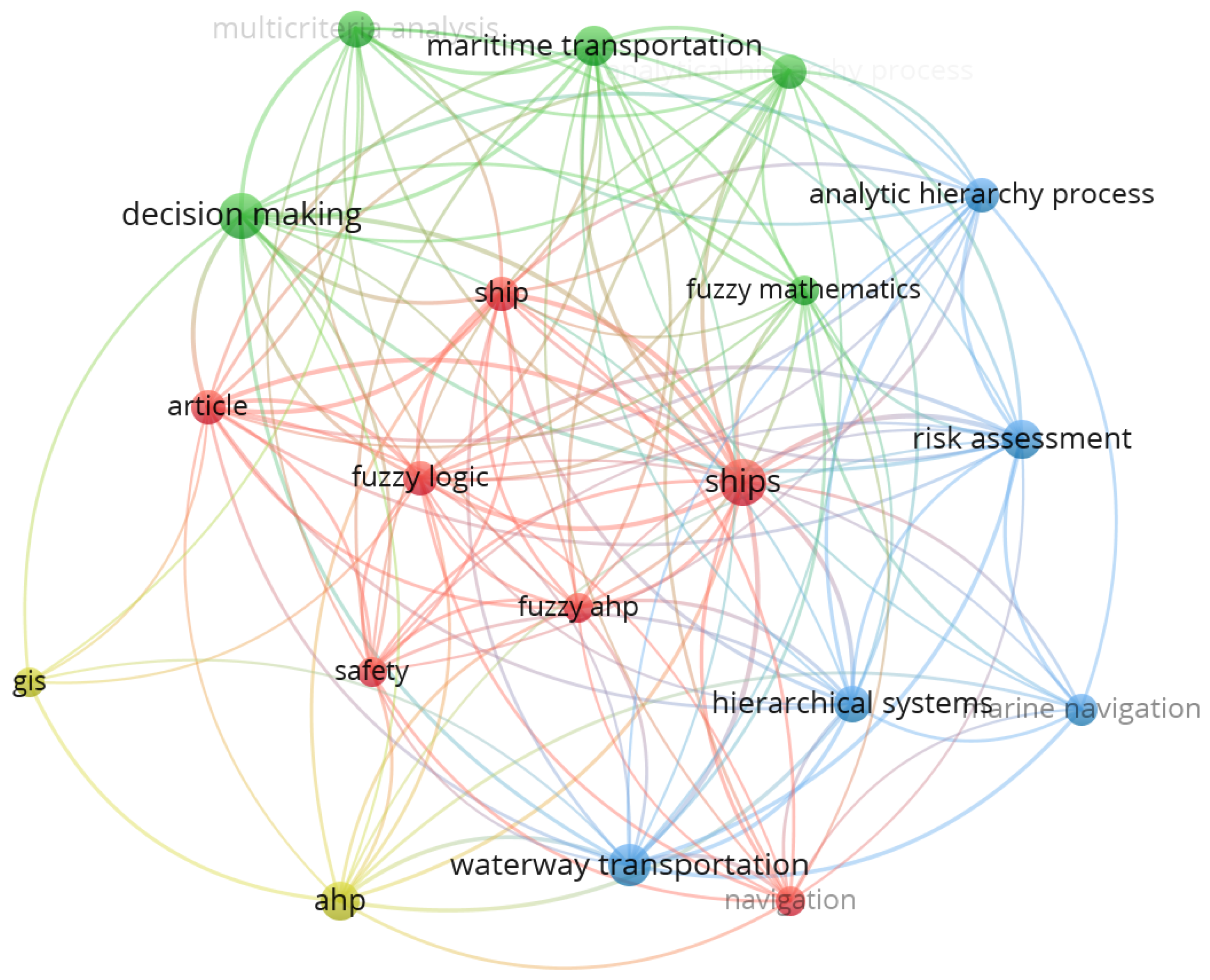
A comprehensive keyword analysis of the titles and abstracts of the reviewed papers was conducted to identify the most commonly used keywords using the VOSviewer software. A total of 19 words were identified, appearing in at least 10 publications, and were selected to generate an appearance score to identify the most relevant keywords among published articles. The analysis showed that the 5 most commonly used keywords (in order of appearance frequency) were analysis, Analytic Hierarchy Process (AHP), ships, decision making, and risk assessment (Figure 1).
In every submission of scientific articles, the keywords selected for the title and abstract are essential. Keywords can describe the depth, analysis, issues, and results of a scientific article at a glance. Thus, the authors created a keyword map that includes the most used keywords in published articles and exhibits the researchers’ views and the emphasis of their research on climate change and sea turtles.

2.3. Countries

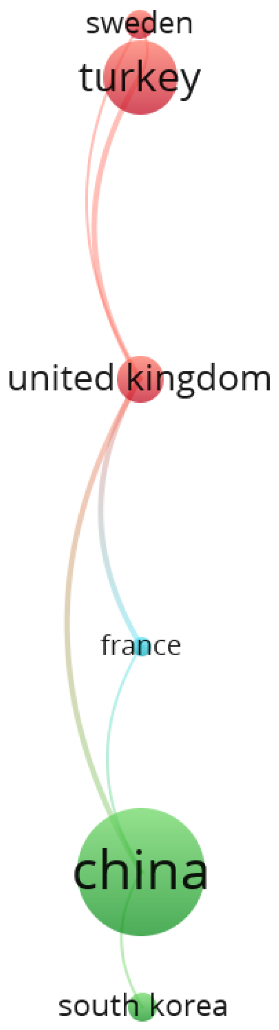
The Scopus database was imported into the VOSviewer software and analyzed to generate a contribution score and identify the countries leading worldwide research in the studied field. The analysis showed that the UK, China, and Turkey contributed the most in the field. The most significant links appear between China, the UK, Turkey, Sweden, France, and South Korea. The USA, Iran, Canada, and Croatia have also conducted research on marine traffic applications using decision-making tools (Figure 2).

2.4. Estimating Marine Traffic Hotspots Using a GIS Methodology

A vector grid file of 10 km was created in the study area (includes 3267 cells and occupies an area of 307,295.32 km2), to be the base grid for the mapping of marine traffic across the Ionian Sea and the South Adriatic Sea (as this area was screened by the BlueCoast project and a panel of experts) regarding the critical habitats of the sea turtle Caretta caretta along its life cycle (i.e., nesting sites, foraging wintering areas and migration routes). The density of marine traffic (routes/years) by cargo vessels was estimated using available data from the Marine Traffic database (density maps: https://www.marinetraffic.com/), where these images were converted to Red, Green, and Blue (RGB) format in order to quantify the density, based on a single-layer spectrum (the same analysis can be applied to container, fishing, passenger, pleasure, tanker, tug, and gascarrier types of vessels).
Initially, in the selected single band of RGB, the main grid was overlaid, and the statistical values (mean, max, min, SD, sum) were estimated per cell. The absence of traffic was recorded as NoData, while denser density in the grid had a higher value on the scale of 0–255. The statistical values were estimated using the Zonal Statistics tool in ArcGIS (Esri, ArcGIS Desktop: Release 10.4.1; Environmental Systems Research Institute: Redlands, CA, USA, 2015), and the resulting map was joined to the main grid, enabling transfer of these values to the grid vector file. RGB raster analysis was initially conducted at a 100 × 100 m resolution, with pixel values ranging from 1 (zero pressure) to 255 (maximum pressure). The sea had a unique value of 197 and was replaced with NoData to avoid affecting the statistical calculations per grid. To minimize uncertainty and reduce micro-scale noise while emphasizing overall pressure trends, this data was subsequently aggregated to a 10 × 10 km scale. The marine traffic data were collected from the European Marine Observation and Data Network (EMODnet) database [27].

3. Results

3.1. Existing Decision-Making Tools for Marine Traffic Applications

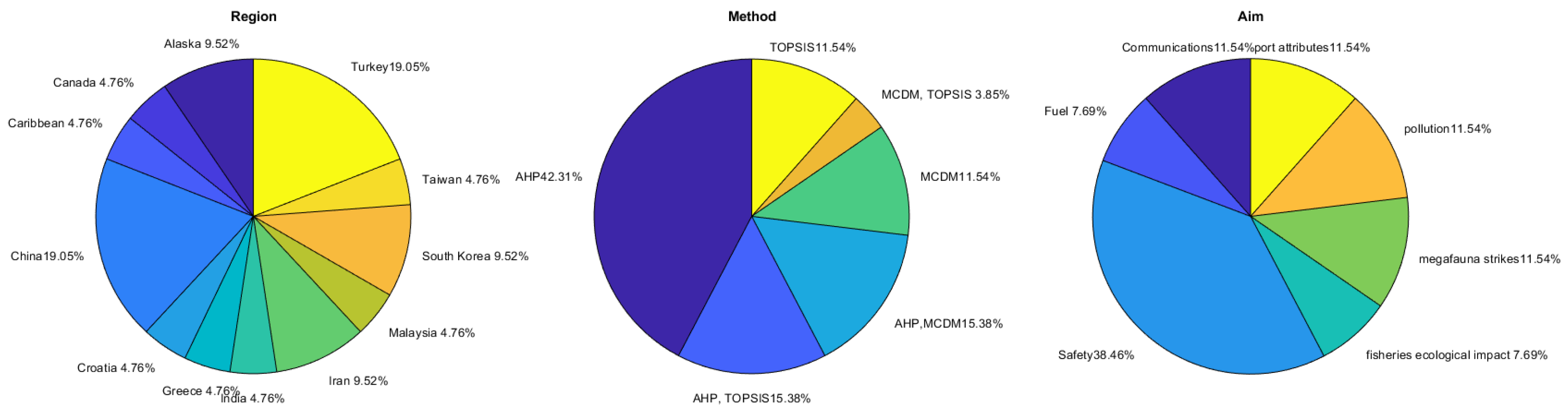
The current literature on marine traffic applications using decision-making tools, such as AHP, Technique for Order Preference by Similarity to Ideal Solution (TOPSIS), and Multiple Criteria Decision Making (MCDM), is mainly focused on the safety of cargo vessels and the minimization of collisions with other vessels through strategic management frameworks that enhance vessel performance and effectiveness [28,29,30,31,32] (Table 1). Moreover, studies also include risk assessments to prevent maritime accidents and reduce loss of life at sea [33,34,35,36]. Also, studies have used decision-making tools to evaluate oceanographic features and detect changes in environmental conditions to increase maritime safety [37]. Besides safety, researchers are also interested in improving communication systems to build real-time, effective maritime node selection algorithms, enhance the navigation system, and manage marine traffic pressure [38,39,40]. Another important aspect of the maritime industry is the management of different port attributes, such as selecting the location for container transshipment, yard gantry crane efficiency in marine container terminals, and general port services [41,42,43]. Other studies have used decision-making tools to highlight pollution caused by the maritime industry, and more specifically, the impact of ballast water, and the need for innovative solutions to prevent impacts on local ecosystems, the distribution of incidental oil spills, and the need for monitoring and decision-making tools for authorities to mitigate the risks of oil spills and protect marine life in such occasions [44,45,46]. Considering the direct influence of marine traffic on marine biodiversity and its ecological impacts, only a few studies exist that have mainly proposed the use of decision-making tools to monitor the impact of large vessels on marine megafauna (such as whales) and apply avoidance techniques to reduce collision probability with marine megafauna species [12,19,47]. To a lesser extent, some studies have also used and proposed the need for decision-making approaches to evaluate the impact of small-scale fisheries traffic on marine species (such as collisions, bycatch, debris, light pollution, oiling, etc.) [48,49]. Finally, researchers are also investigating the use of alternative fuels and the need for multi-criteria decision-making for their selection in large vessels, as well as their potential impacts on the marine environment [50,51].
The majority of studies have used AHP in their methodologies (42%), with TOPSIS and MCDM being used in 12% and 12% of other studies, respectively. A combination of AHP with TOPSIS or MCDM was also popular, with 30% of the studies using one of those combinations, while the TOPSIS–MCDM combination was less used (Figure 3). Considering the criteria used for applying the selected method (Table 2), most studies have included various environmental parameters in their analysis (such as bathymetry, weather conditions, tidal current activity, marine ecosystems, and marine protected areas). The second most commonly used criterion concerns the vessel’s condition and various attributes (such as length, breadth, deadweight, built year, ballast water capacity, and ship condition), as well as traffic conditions (ship entries in a region, traffic control, and accident-prone areas). The third most used criteria involve human error, infrastructure, and machinery and technological equipment (such as operator fatigue, command process, personnel capabilities, equipment, and infrastructure). The rest of the most common criteria include the navigation conditions (such as the maneuver process and navigation aids), the vessel traffic center and port attributes (such as the technological infrastructure of ports, port location, port efficiency, and rescue resources), pollution (such as oil spill probabilities and sensitive protected areas), fishing areas (such as fishing boat presence and fishing activity), economical reasons, and the legal framework (such as regulations and protected areas). All the aforementioned criteria have been used in studies using the AHP process, while fishing activity has not been used in studies using TOPSIS, and the vessel condition/attributes have not been used in MCDM models.

3.2. The GIS Methodology’s Results

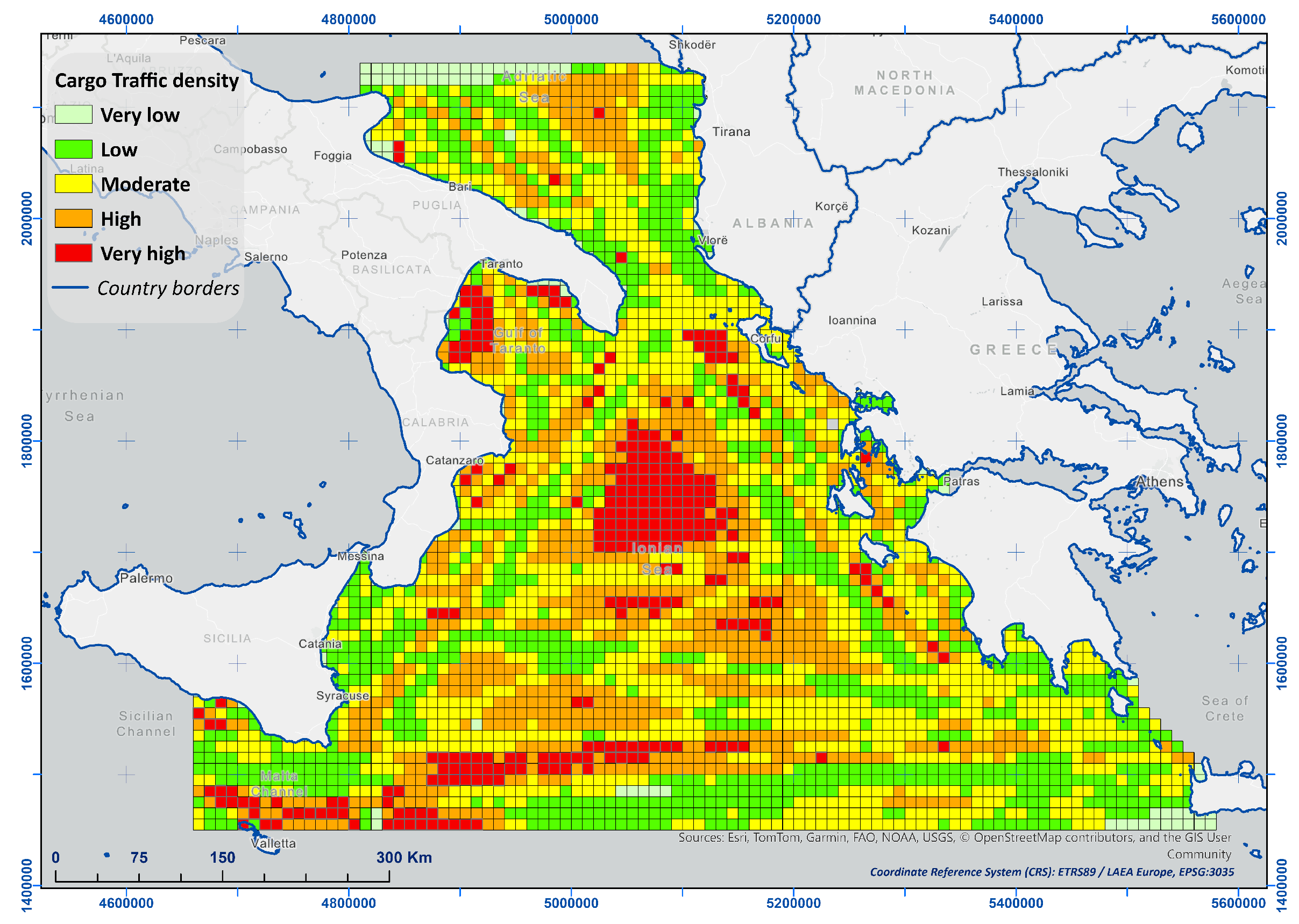
To create a thematic and quantitative map based on cargo vessel information, a multi-field file was created containing traffic values (for sum statistics), based on the main grid file (Figure 4). The map shows cargo traffic density in the Ionian and South Adriatic Seas and shows that the greater extent of this region is under high and/or very high density.

4. Decision-Making Model

4.1. AHP Weight Assessment Methodology

The proposed methodology used the AHP method to assign a weight to each contributing criterion for marine traffic collisions with marine megafauna species. The criteria were scaled pair-wise according to the methodology proposed by previous studies [53,54], and given a scale from 1 (the two criteria are equally important) to 9 (the first criterion is extremely more important), according to the current literature and an expert panel (Table 3) as shown in Table 4. The pair-wise comparison ( α i j ) is shown in Table 5, where a specific rule applies. If two criteria are of equal importance, then α i j = α j i = 1 .
After making pair-wise comparisons, estimations are made to yield the final set of criterion weights (elicitation method: eigenvector). More specifically, the principal eigenvalue and the corresponding normalized right eigenvector of the comparison matrix that is calculated provide the relative importance of the various criteria being compared. The elements of the normalized eigenvector were the weights ( w i ) of the criteria or sub-criteria (Table 6). Finally, the consistency ratio (CR) of the pairwise comparisons was evaluated to ensure the expert panel’s judgment was consistent. With a generally acceptable CR of less than 0.1 [33], we determined it to be 0.089 in the present work.

4.2. TOPSIS Methodology

The weights are further used in the proposed model for the application of TOPSIS and more specifically, for calculating the weighted rating of the criteria as follows:
v i j = w i . μ i j
where w i is the weight and μ i j is the value of the i t h criterion.
The next step involves identifying the Positive-Ideal and Negative-Ideal Solutions. The positive ideal solution is the composite of all best attribute ratings attainable, and is denoted:
T + = ( μ 1 + , μ 2 + , , μ 6 + )
where μ i + is the best value for the i t h criterion among all alternatives.
The negative-ideal solution is the composite of all worst attribute ratings attainable, and is denoted as follows:
T = ( μ 1 , μ 2 , , μ 6 )
where μ i is the worst value for the i t h criterion among all alternatives.
The separation of each alternative from the positive-ideal solution T + , is given by the n-dimensional Euclidean distance:
S j + = i = 1 6 ( μ i j μ i + ) 2
where j is the index related to the alternatives and i to one of the six criteria.
Similarly, the separation from the negative-ideal solution is given by the following:
S j = i = 1 6 ( μ i j μ i ) 2
The similarity to the positive-ideal solution, for alternative j, is finally given by the following:
C j + = S j S j + + S j
with 0 C j + 1 . The alternatives can then be ranked according to C j + in descending order.

4.3. Sensitivity Analysis

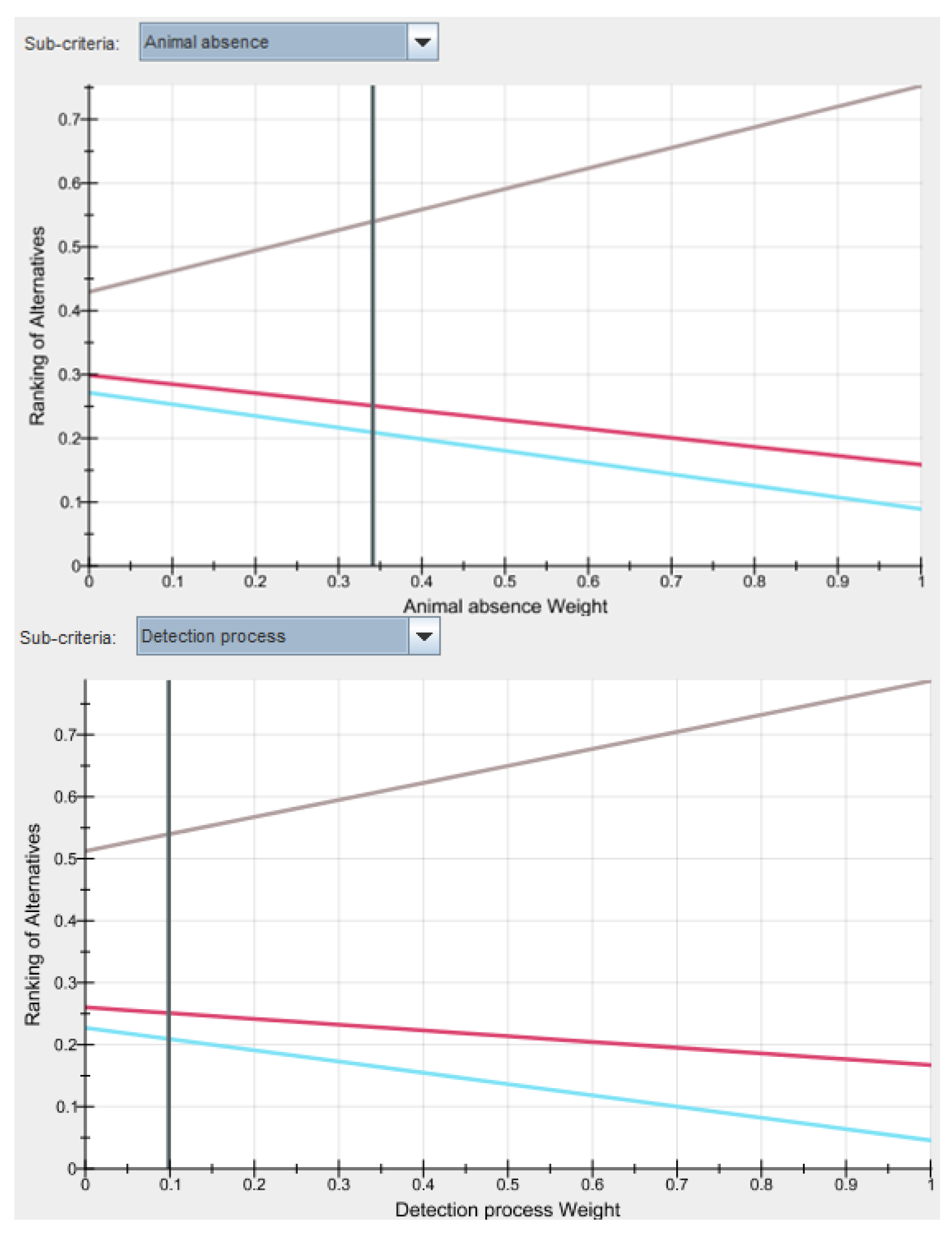
In terms of simplicity, we run a sensitivity analysis using only 3 alternatives (Re-routing, Observers-avoidance, and Lower Speed). Figure 5 illustrates how the alternatives perform with respect to the animal absence criterion (up) and as the detection process criterion (down). One can see that by shifting the current value of the weight, there is no change in the ranking. This behavior can also be observed in other criteria. Thus, the AHP model is considered robust.

5. Discussion

Management authorities and the general public understand the importance of marine megafauna and are constantly alerted to implications regarding their well-being [47]. Existing methods include projections of shipping routes and probabilities of marine species occurrence on regional scales [3]. Recent technical and operational efforts for reducing the impact of large vessels on marine megafauna involved the use of alternative shipping routes based on species spatial and temporal occurrence [55,56,57], reduced vessel speed [23,58,59], acoustic networks [60], thermal night navigators [61], predictive modeling [62,63], and active avoidance using observers on board large vessels, with the ultimate goal of reducing the frequency and severity of collisions [12,19,64,65]. However, these techniques are criticized as unreliable due to the lack of information on marine species movement, aggregations, and residency times [66].
The International Maritime Organization (IMO) is the United Nations (UN) agency that is responsible for the safety and sustainability of the vessels and mariners at sea, as well as the conservation of the marine environment and prevention of pollution by the shipping industry, through the development and implementation of a management framework for the shipping industry [67]. Considering vessel collisions with marine megafauna, the IMO’s action is considered limited [19]. Organizations such as the International Whaling Commission (IWC) and the Agreement on the Conservation of Cetaceans of the Black Sea, Mediterranean Sea, and contiguous Atlantic area (ACCOBAMS) have proposed mitigation approaches that are subject to limitations and are not holistic, which render the IMO unable to adopt and implement [19].
To date, some promising results are being reported in holistic approaches that have incorporated the maritime industry in their methods, using known avoidance techniques and the voluntary participation of stakeholders to reduce the frequency of collisions [64,68,69,70]. It is vital to develop an international database of collision records that includes information on species, region, vessel type, and the collision outcome (e.g., mortality, severe injury, light injury) to support regional implementation of mitigation techniques [71]. This would assist in estimating hotspots of collisions, promote collaborations among relevant stakeholders, and introduce direct management actions to reduce this phenomenon and its impact on the marine ecosystem [72].

5.1. Need for a Decision-Making Framework for Ship-Megafauna Collision Prevention in the Ionian Sea: Structure and Criteria

In the Ionian Sea, a hotspot for marine megafauna species such as cetaceans, sea turtles, monk seals, seabirds, etc. [73,74], collisions between vessels and marine organisms are a common phenomenon that concerns the IWC [75]. Cargo vessel routes occupy similar marine regions with marine megafauna, with several strandings of sperm whales and sea turtles being reported [76,77,78]. However, studies have shown that even small changes (such as changes by 5–10 nautical miles in the shipping routes) can have a significant impact on the preservation of the species by reducing the number of vessel strikes [71]. Combined with an analysis of the potential impact on the shipping industry, the proposal and adoption of mitigation approaches by the local authorities can lead to the inclusion of the shipping industry in the protection of the marine environment [79].
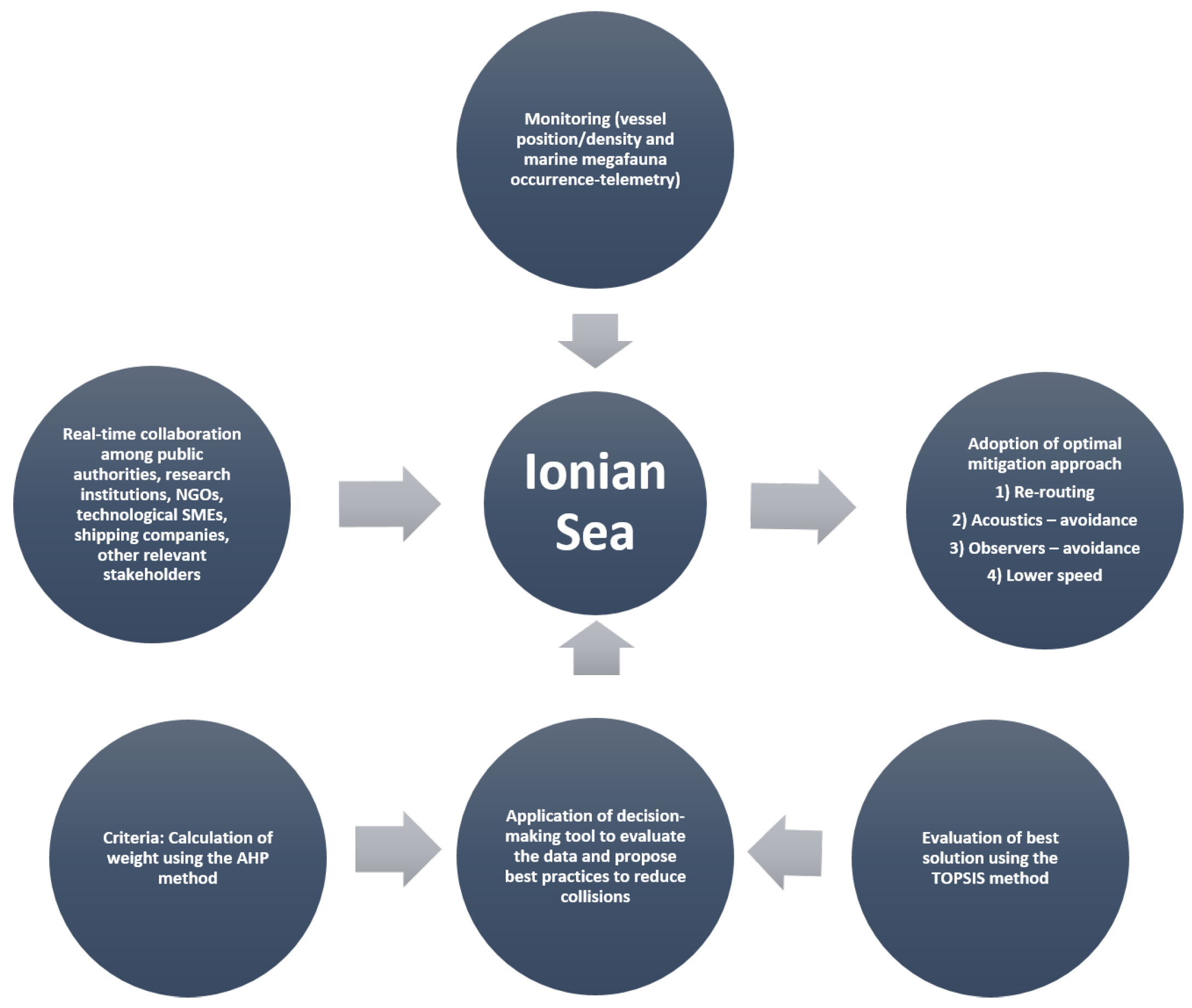
Taking into account the described methodology for monitoring marine traffic in the Ionian Sea region (Figure 4), the authors suggest developing a decision-making framework to mitigate collisions between ships and marine megafauna in the study area. The process is based on the necessity for collaboration among research institutions, public authorities, NGOs, and shipping companies to apply a decision-making tool that will evaluate the monitoring information (vessel position/density and occurrence of animal groups from telemetry/direct observations), will alert local authorities and vessels through an early-warning system, and propose the most accurate mitigation technique (e.g., re-routing, speed decrease, acoustic applications, on-board observers, etc.) to avoid a potential collision (Figure 6). The application of the tool will benefit from the use of specific criteria (Table 2) (their weights are calculated using the AHP method as used in previous studies), and the evaluation of the best solution using the TOPSIS method, based on stakeholders’ needs and the problem (see methodology sections on AHP and TOPSIS).

5.2. Critical Analysis of Similar Decision-Making Frameworks

The literature review showed that the majority of existing decision-making tools are being used by the maritime industry with the scope of increasing the safety, reducing the time and costs, and preventing the pollution of the marine environment. Little attention is being given to collisions with marine megafauna, which in reality do not affect large vessels, and in many regions, there is no legal framework for penalties in such events. Hence, there is a lack of knowledge and tools to mitigate such events.
Similar decision-making frameworks that have been developed for different goals (such as safety, costs, communications, fuels, etc.) have mostly adopted the AHP and TOPSIS methods for the evaluation and weight of different criteria (see criteria pool in Table 2), as well as for finding the ideal solutions, based on the target goals. The use of the AHP and TOPSIS methods has been tested and shown to be effective and feasible [28,45,49], their findings are easily communicated to the relevant stakeholders [33,47], and in most cases can be used for conservation planning and the general protection of the marine environment [44,48]. Consequently, the proposed approach is based on existing methods that have already been proven to be valuable for marine conservation, setting the ground for an effective and accurate decision-making framework.

5.3. Application of the Proposed Framework

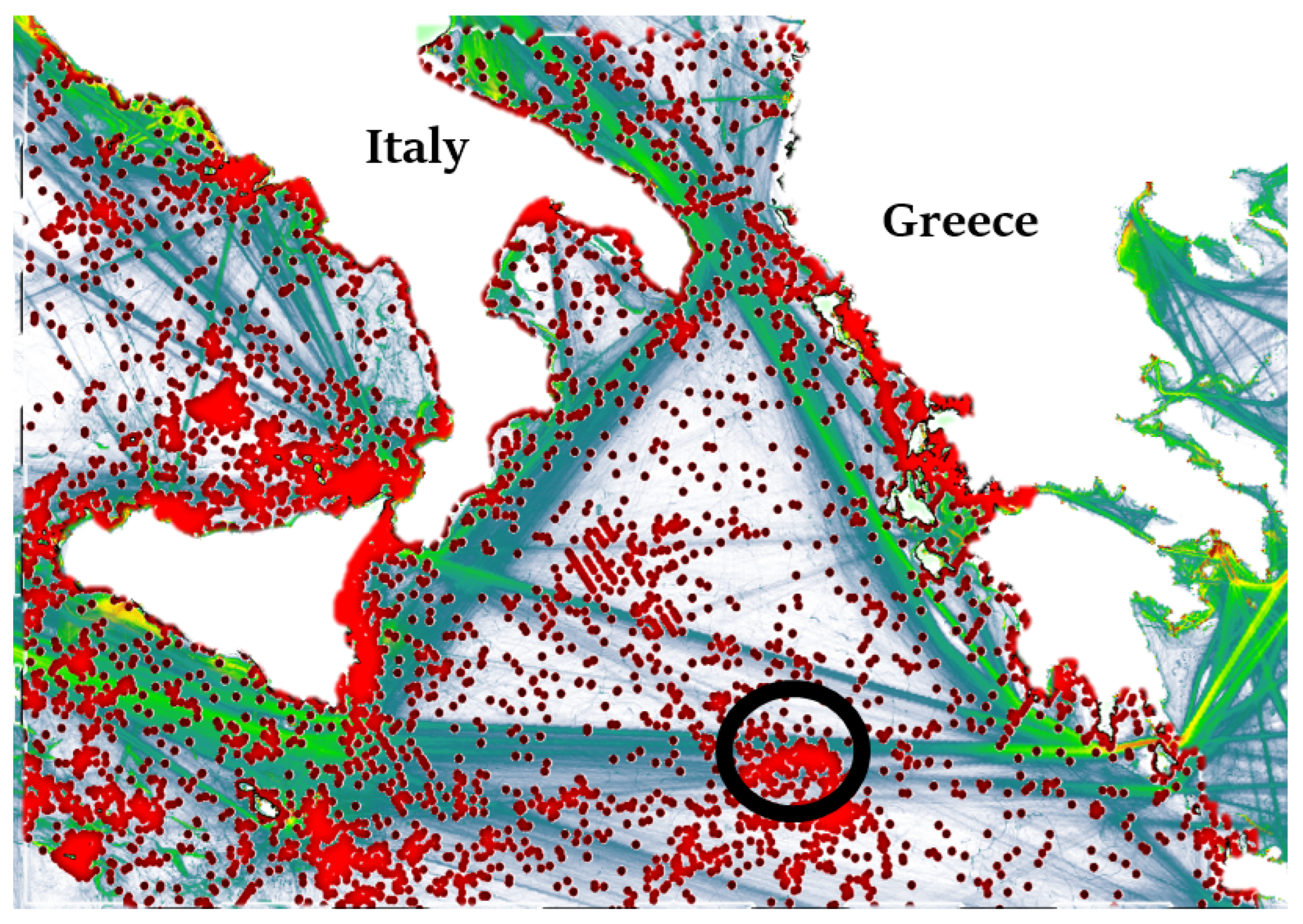
To illustrate the proposed decision-making framework with an example, the authors evaluated total marine traffic routes in the Ionian Sea using the EMODnet database [27] and the presence of marine megafauna species (marine mammals and sea turtles) using the OBIS-SEAMAP database [80]. Overlaying the density of marine organisms on top of the marine traffic routes in the study area provided several areas with potential hazards for vessel strikes on marine megafauna organisms (Figure 7). Focusing on one of these locations to apply the proposed framework, we evaluated the selected criteria and known mitigation practices to propose the best solution for the selected region. The criteria were ranked (low, moderate, high) based on their importance for implementing the specific solution, according to the comprehensive literature review of studies using similar criteria and the AHP/TOPSIS methodologies described in previous sections (Table 7).
The use of acoustics for monitoring, identifying, and avoiding marine organisms by crew members on board large vessels in the Ionian Sea region was determined to be the most demanding process, especially given the high costs associated with such systems and the training required for detection. It also requires certain infrastructure on board the vessels. Re-routing and detecting marine megafauna species using observers on board the vessels was ranked as “moderate” as it requires fewer expenses, training, and machinery. Both methods are very promising solutions for the mitigation of vessel strikes on marine organisms. Finally, decreasing vessel speeds is the least demanding approach to reducing the risk of a vessel strike.
The combination of Table 7 and the decision-making model (Equation (6)) resulted in acoustics-avoidance being the most promising solution ( C = 0.75094 ), with re-routing being the second most promising solution ( C = 0.74828 ), and observers-avoidance and lower speed being the least promising, with both exhibiting the same value ( C = 0.5 ). Thus, the most appropriate solution to mitigate marine traffic collisions with marine megafauna in this area is a combination of re-routing and the use of acoustics to detect and avoid marine organisms.
In order to adopt the ideal mitigation approach, or a combination of approaches, the findings are directly communicated to the most relevant stakeholders, depending on the location. In the current case (Figure 7), the threatened area is located in the Mediterranean high seas between Greece and Italy according to the agreement on the delimitation of the respective continental shelf areas from 1977 [81], and is under the jurisdiction of the European Union and the UN High Seas Treaty [82]. The proposed framework will then notify these public authorities about the best mitigation approaches for the specific location. Moreover, the shipping companies that pass through the area (extracted from www.marinetraffic.com) will also be informed of the details of the proposed solutions. Working together with the companies and legal authorities is crucial for the implementation of such actions. Furthermore, the findings will be disseminated to environmental NGOs working on the conservation of marine megafauna in the Mediterranean Sea to further communicate and advocate for the adoption of approaches to mitigate vessel strikes on marine organisms.

5.4. Transferability to Other Regions

The proposed framework has applied to the specific case shown in Figure 7 as a testbed to describe the methodology and important steps to reach the optimal solution. The marine traffic routes, marine megafauna density from telemetry data, and the legal framework are site-specific and should be determined before applying the decision-making framework. Moreover, the expert panel used to implement the Ionian Sea case comprises researchers from the Mediterranean region, as they are familiar with the area, its legal aspects, issues, and marine biodiversity. Adopting the proposed framework to another region would require the establishment of an expert panel of local researchers. Finally, the mitigation approaches described and presented here are also site-specific and should be reviewed for other regions, as some may not apply (e.g., acoustics may not be an option for regions with vessels that lack recent technological development, re-routing may not be an option in narrow channels, etc.).

5.5. Global-Scale Adoption of the Proposed Framework

The proposed framework described in this work can be proven useful to the IMO’s Particular Sensitive Sea Areas (PSSAs) project, a management tool for protecting and conserving ecologically important marine biodiversity from shipping activities worldwide [83]. Although PSSAs are subject to the IMO’s judgement and do not include a legal character, the adoption of the proposed decision-making framework that incorporates expert opinion and marine traffic data, and provides site-specific solutions, could strengthen the PSSAs’ link with the United Nations Convention on the Law of the Sea.
Furthermore, the proposed framework can be useful to the United Nations Decade of Ocean Science for Sustainable Development (2021–2030), the “Ocean Decade”, a policy framework that coordinates various stakeholders to engage and collaborate for the protection and conservation of the marine environment. According to the Ocean Decade, vessel collisions with marine megafauna species are a high priority for the 2021–2030 decade, with data sharing and mitigation actions being highlighted as needed in their reports [84]. The Ocean Decade could benefit from the proposed framework, as it can provide optimal solutions for specific areas and scenarios.

6. Conclusions

The use of decision-making tools in marine traffic applications has expanded to several sectors, with a main focus on maritime safety and communication. However, their use for protecting marine biodiversity and mitigating vessel strikes on marine megafauna is very limited. Focusing on the Ionian region in the central Mediterranean Sea, the authors propose a decision-making framework that leverages the well-established and used in other applications AHP and TOPSIS methodologies to identify the best solutions for mitigating vessel strikes on marine megafauna species. Furthermore, this work presents an example use of the proposed framework in a specific location of the Ionian Sea, where shipping routes coincide with high densities of marine megafauna species (marine mammals and sea turtles), and determines that a combination of re-routing, decreasing speed, and/or using on-board observers would be the ideal solution to vessel strikes in that region. Finally, the study discusses the relevant stakeholders that should be informed about the specific example’s findings. This is the first step in identifying, quantifying, and mitigating the impact of vessel strikes on marine megafauna species in the region, and future research is required to fully understand the inclusion of the relevant stakeholders, the dissemination of the framework’s findings, and the potential to advocate for a legal framework that will advise shipping companies to comply with best practices to reduce collisions with marine megafauna organisms. Finally, the use of additional test cases worldwide will help inform all aspects of the proposed framework and validate its applicability across different regions and scenarios.

Author Contributions

N.S.: conceptualization, investigation, data curation, writing—original draft, visualization, formal analysis. K.P.: methodology, software, resources, data curation, formal analysis, writing—review and editing. K.K.: conceptualization, supervision, project administration, resources, writing—review and editing. All authors have read and agreed to the published version of the manuscript.

Funding

This work was supported by the Interreg IPA II Cross Border Cooperation Program Greece–Albania, 2014–2020 (BLUE COAST project: Climate-Smart Coastal Practices for Blue governance).

Institutional Review Board Statement

Not applicable.

Informed Consent Statement

Not applicable.

Data Availability Statement

The original contributions presented in this study are included in the article. Further inquiries can be directed to the corresponding author.

Conflicts of Interest

The authors declare no known competing financial interests or personal relationships that could have appeared to influence the work reported in this paper.

References

  1. UN. Review of Maritime Transport 2020. In Proceedings of the United Nations Conference on Trade and Development (UNCTAD), Virtual, 3–7 October 2020; p. 159. [Google Scholar]
  2. Sequeira, A.M.M.; Hays, G.C.; Sims, D.W.; Eguíluz, V.M.; Rodríguez, J.P.; Heupel, M.R.; Harcourt, R.; Calich, H.; Queiroz, N.; Costa, D.P.; et al. Overhauling ocean spatial planning to improve marine megafauna conservation. Front. Mar. Sci. 2019, 6, 639. [Google Scholar] [CrossRef]
  3. Schoeman, R.P.; Patterson-Abrolat, C.; Plön, S. A global review of vessel collisions with marine animals. Front. Mar. Sci. 2020, 7, 292. [Google Scholar] [CrossRef]
  4. Stelfox, M.; Hudgins, J.; Sweet, M. A review of ghost gear entanglement amongst marine mammals, reptiles and elasmobranchs. Mar. Pollut. Bull. 2016, 111, 6–17. [Google Scholar] [CrossRef] [PubMed]
  5. Queiroz, N.; Humphries, N.E.; Couto, A.; Vedor, M.; Da Costa, I.; Sequeira, A.M.; Mucientes, G.; Santos, A.M.; Abascal, F.J.; Abercrombie, D.L.; et al. Global spatial risk assessment of sharks under the footprint of fisheries. Nature 2019, 572, 461–466. [Google Scholar] [CrossRef]
  6. Worm, B.; Davis, B.; Kettemer, L.; Ward-Paige, C.A.; Chapman, D.; Heithaus, M.R.; Kessel, S.T.; Gruber, S.H. Global catches, exploitation rates, and rebuilding options for sharks. Mar. Policy 2013, 40, 194–204. [Google Scholar] [CrossRef]
  7. Simantiris, N.; Dimitriadis, C.; Xirouchakis, S.; Voulgaris, M.D.; Beka, E.; Vardaki, M.Z.; Karris, G. Combining methods for detection of bycatch hotspot areas of marine megafauna species in and around critical rookeries and foraging areas. Mar. Environ. Res. 2025, 210, 107299. [Google Scholar] [CrossRef]
  8. Simantiris, N. The impact of climate change on sea turtles: Current knowledge, scientometrics, and mitigation strategies. Sci. Total Environ. 2024, 923, 171354. [Google Scholar] [CrossRef]
  9. Duarte, C.M.; Chapuis, L.; Collin, S.P.; Costa, D.P.; Devassy, R.P.; Eguiluz, V.M.; Erbe, C.; Gordon, T.A.; Halpern, B.S.; Harding, H.R.; et al. The soundscape of the Anthropocene ocean. Science 2021, 371, eaba4658. [Google Scholar] [CrossRef]
  10. Laist, D.W.; Knowlton, A.R.; Mead, J.G.; Collet, A.S.; Podesta, M. Collisions between ships and whales. Mar. Mammal Sci. 2001, 17, 35–75. [Google Scholar] [CrossRef]
  11. Gudger, E. Whale Sharks Rammed by Ocean Vessels: How These Sluggish Leviathans Aid in Their Own Destruction; New England Naturalist; Storstockholms Lokaltrafik: Stockholm, Sweden, 1940; Volume 7, pp. 1–10. [Google Scholar]
  12. Gende, S.M.; Vose, L.; Baken, J.; Gabriele, C.M.; Preston, R.; Hendrix, A.N. Active whale avoidance by large ships: Components and constraints of a complementary approach to reducing ship strike risk. Front. Mar. Sci. 2019, 6, 592. [Google Scholar] [CrossRef]
  13. Hazel, J.; Lawler, I.R.; Marsh, H.; Robson, S. Vessel speed increases collision risk for the green turtle Chelonia mydas. Endanger. Species Res. 2007, 3, 105–113. [Google Scholar]
  14. McKenna, M.F.; Calambokidis, J.; Oleson, E.M.; Laist, D.W.; Goldbogen, J.A. Simultaneous tracking of blue whales and large ships demonstrates limited behavioral responses for avoiding collision. Endanger. Species Res. 2015, 27, 219–232. [Google Scholar] [CrossRef]
  15. VanCompernolle, M.; Morris, J.; Calich, H.J.; Rodríguez, J.P.; Marley, S.A.; Pearce, J.R.; Abrahms, B.; Abrantes, K.; Afonso, A.S.; Aguilar, A.; et al. Vulnerability of marine megafauna to global at-sea anthropogenic threats. Conserv. Biol. 2025, e70147. [Google Scholar] [CrossRef] [PubMed]
  16. Thomas, P.O.; Reeves, R.R.; Brownell, R.L., Jr. Status of the world’s baleen whales. Mar. Mammal Sci. 2016, 32, 682–734. [Google Scholar] [CrossRef]
  17. Fais, A.; Lewis, T.P.; Zitterbart, D.P.; Álvarez, O.; Tejedor, A.; Aguilar Soto, N. Abundance and distribution of sperm whales in the Canary Islands: Can sperm whales in the archipelago sustain the current level of ship-strike mortalities? PLoS ONE 2016, 11, e0150660. [Google Scholar]
  18. Reimer, J.; Gravel, C.; Brown, M.W.; Taggart, C.T. Mitigating vessel strikes: The problem of the peripatetic whales and the peripatetic fleet. Mar. Policy 2016, 68, 91–99. [Google Scholar] [CrossRef]
  19. Sèbe, M.; Christos, A.K.; Pendleton, L. A decision-making framework to reduce the risk of collisions between ships and whales. Mar. Policy 2019, 109, 103697. [Google Scholar] [CrossRef]
  20. IWC. Annual Report of the International Whaling Commission; International Whaling Commission: Cambridge, UK, 2005; p. 11. [Google Scholar]
  21. Jacob, T.; Ody, D.; David, L.; Di-Meglio, N.; Folegot, T. Characteristics of maritime traffic in the Pelagos sanctuary and analysis of collision risk with large cetaceans. In From the Report of Quiet Oceans and Institut EcoOcéans; Quiet-Oceans: Plouzané, France, 2016. [Google Scholar]
  22. Silber, G.K.; Bettridge, S.O.M. An Assessment of the Final Rule to Implement Vessel Speed Restrictions to Reduce the Threat of VESSEL collisions with North Atlantic Right Whales; NOAA Fisheries: Silver Spring, MD, USA, 2012.
  23. Vanderlaan, A.S.; Taggart, C.T. Vessel collisions with whales: The probability of lethal injury based on vessel speed. Mar. Mammal Sci. 2007, 23, 144–156. [Google Scholar]
  24. Stopford, M. How shipping has changed the world and the social impact of shipping. In Proceedings of the Global Maritime Environmental Congress, Hamburg, Germany, 6 September 2010; Volume 7, pp. 1–10. [Google Scholar]
  25. UN. Review of Maritime Transport 2012. In Proceedings of the United Nations Conference on Trade and Development (UNCTAD), Doha, Qatar, 21–26 April 2012; p. 159. [Google Scholar]
  26. Womersley, F.C.; Humphries, N.E.; Queiroz, N.; Vedor, M.; da Costa, I.; Furtado, M.; Tyminski, J.P.; Abrantes, K.; Araujo, G.; Bach, S.S.; et al. Global collision-risk hotspots of marine traffic and the world’s largest fish, the whale shark. Proc. Natl. Acad. Sci. USA 2022, 119, e2117440119. [Google Scholar]
  27. Calewaert, J.B.; Weaver, P.; Gunn, V.; Gorringe, P.; Novellino, A. The European Marine Data and Observation Network (EMODnet): Your gateway to european marine and coastal data. In Quantitative Monitoring of the Underwater Environment: Results of the International Marine Science and Technology Event MOQESM 14 in Brest, France; Springer: Berlin/Heidelberg, Germany, 2016; pp. 31–46. [Google Scholar]
  28. Akyildiz, H.; Mentes, A. An integrated risk assessment based on uncertainty analysis for cargo vessel safety. Saf. Sci. 2017, 92, 34–43. [Google Scholar] [CrossRef]
  29. Arslan, O.; Turan, O. Analytical investigation of marine casualties at the Strait of Istanbul with SWOT–AHP method. Marit. Policy Manag. 2009, 36, 131–145. [Google Scholar] [CrossRef]
  30. Fallahzadeh, M.; Moghaddam, M.; Talebnezhad, H. Evaluating safety control criteria in maritime traffic using formal safety assessment (case study: Iranian port; bushehr). J. Marit. Res. 2015, 12, 37–48. [Google Scholar]
  31. Ren, S. Evaluation of ship traffic control safety based on analytic hierarchy process. In Proceedings of the 2010 International Conference on Intelligent Computation Technology and Automation, Changsha, China, 11–12 May 2010; Volume 2, pp. 237–240. [Google Scholar]
  32. Wu, B.; Yan, X.; Wang, Y.; Soares, C.G. Selection of maritime safety control options for NUC ships using a hybrid group decision-making approach. Saf. Sci. 2016, 88, 108–122. [Google Scholar] [CrossRef]
  33. Hanafiah, R.M.; Zainon, N.S.; Karim, N.H.; Rahman, N.S.F.A.; Behforouzi, M.; Soltani, H.R. A new evaluation approach to control maritime transportation accidents: A study case at the Straits of Malacca. Case Stud. Transp. Policy 2022, 10, 751–763. [Google Scholar] [CrossRef]
  34. Hu, B.; Jiang, X.; de Souza, E.N.; Pelot, R.; Matwin, S. Identifying fishing activities from AIS data with conditional random fields. In Proceedings of the 2016 Federated Conference on Computer Science and Information Systems (FedCSIS), Gdansk, Poland, 11–14 September 2016; pp. 47–52. [Google Scholar]
  35. Tonoğlu, F.; Atalar, F.; Başkan, İ.B.; Yildiz, S.; Uğurlu, Ö.; Wang, J. A new hybrid approach for determining sector-specific risk factors in Turkish Straits: Fuzzy AHP-PRAT technique. Ocean Eng. 2022, 253, 111280. [Google Scholar] [CrossRef]
  36. Zhang, M.-Y.; Zhang, D.; Guo, H.; Fu, S.-S.; Huang, Y.-M. Complexity metric of waterborne traffic flow based on Lempel-Ziv algorithm and TOPSIS. J. Traffic Transp. Eng. 2017, 17, 109–118. [Google Scholar]
  37. Polo-Castañeda, M.; Gomez-Rojas, J.; Linero-Cueto, J. Application of AHP and GIS for determination of suitable wireless sensor network zones for oceanographic monitoring in the South Caribbean Sea upwelling zone. Int. J. Adv. Sci. Eng. Inf. Technol. 2021, 11, 1696–1703. [Google Scholar] [CrossRef]
  38. Mao, Z.Y.; Zhang, Z.L.; Liu, X.G.; Kang, J.F. Network selection algorithm for maritime mobile nodes based on dynamic AHP. Syst. Eng. Electron. 2022, 44, 2011. [Google Scholar]
  39. Zhang, M.; Zhang, D.; Fu, S.; Kujala, P.; Hirdaris, S. A predictive analytics method for maritime traffic flow complexity estimation in inland waterways. Reliab. Eng. Syst. Saf. 2022, 220, 108317. [Google Scholar] [CrossRef]
  40. Wang, J.; Wang, X.; Zhou, J. Model selection for predicting marine traffic flow in coastal waterways using deep learning methods. Ocean Eng. 2025, 329, 121151. [Google Scholar] [CrossRef]
  41. Zabihi, A.; Gharakhani, M.; Afshinfar, A. A multi criteria decision-making model for selecting hub port for Iranian marine industry. Uncertain Supply Chain. Manag. 2016, 4, 195–206. [Google Scholar] [CrossRef]
  42. Nooramin, A.S.; Sayareh, J.; Moghadam, M.K.; Alizmini, H.R. TOPSIS and AHP techniques for selecting the most efficient marine container yard gantry crane. Opsearch 2012, 49, 116–132. [Google Scholar] [CrossRef]
  43. Hsu, W.K.K. Ports’ service attributes for ship navigation safety. Saf. Sci. 2012, 50, 244–252. [Google Scholar] [CrossRef]
  44. Zhang, X.; Zhang, C.; Chen, X.; Su, P. Evaluation of the vulnerability of Huanghe estuary coastal wetlands to marine oil spill stress. Front. Mar. Sci. 2024, 11, 1481868. [Google Scholar] [CrossRef]
  45. Hung, P.V.; Kim, K.S.; Tien, L.Q.; Cuong, N.M. Distribution of oil spill response capability through considering probable incident, environmental sensitivity and geographical weather in Vietnamese waters. J. Int. Marit. Saf. Environ. Aff. Shipp. 2018, 2, 31–41. [Google Scholar] [CrossRef]
  46. Ejder, E.; Ceylan, B.O.; Celik, M.S.; Arslanoğlu, Y. Sustainability in maritime transport: Selecting ballast water treatment for a bulk carrier. Mar. Environ. Res. 2024, 198, 106511. [Google Scholar] [CrossRef] [PubMed]
  47. Gende, S.; Hendrix, A.N.; Schmidt, J. Somewhere between acceptable and sustainable: When do impacts to resources become too large in protected areas? Biol. Conserv. 2018, 223, 138–146. [Google Scholar] [CrossRef]
  48. Lieske, D.J.; Tranquilla, L.M.; Ronconi, R.; Abbott, S. Synthesizing expert opinion to assess the at-sea risks to seabirds in the western North Atlantic. Biol. Conserv. 2019, 233, 41–50. [Google Scholar] [CrossRef]
  49. Kavadas, S.; Maina, I.; Damalas, D.; Dokos, I.; Pantazi, M.; Vassilopoulou, V. Multi-criteria decision analysis as a tool to extract fishing footprints: Application to small scale fisheries and implications for management in the context of the maritime spatial planning directive. Mar. Sci. 2015, 16, 294–304. [Google Scholar] [CrossRef]
  50. Mandić, N.; Ukić Boljat, H.; Kekez, T.; Luttenberger, L.R. Multicriteria analysis of alternative marine fuels in sustainable coastal marine traffic. Appl. Sci. 2021, 11, 2600. [Google Scholar] [CrossRef]
  51. Wan, C.; Yan, X.; Zhang, D.; Yang, Z. A novel policy making aid model for the development of LNG fuelled ships. Transp. Res. Part Policy Pract. 2019, 119, 29–44. [Google Scholar]
  52. Hu, Y.; Park, G.K. Collision risk assessment based on the vulnerability of marine accidents using fuzzy logic. Int. J. Nav. Archit. Ocean Eng. 2020, 12, 541–551. [Google Scholar] [CrossRef]
  53. Saaty, T.L. Analytic hierarchy process. In Encyclopedia of Operations Research and Management Science; Springer: Berlin/Heidelberg, Germany, 2013; pp. 52–64. [Google Scholar]
  54. Zhu, Y.; Buchmann, A. Evaluating and selecting web sources as external information resources of a data warehouse. In Proceedings of the Proceedings of the Third International Conference on Web Information Systems Engineering, 2002. WISE 2002, Singapore, 14 December 2002; pp. 149–160. [Google Scholar]
  55. Knowlton, A.R.; Brown, M. Running the gauntlet: Right whales and vessel strikes. In The Urban Whale: North Atlantic Right Whales at the Crossroads; Harvard University Press: Cambridge, MA, USA, 2007; pp. 409–435. [Google Scholar]
  56. Vanderlaan, A.S.; Taggart, C.T.; Serdynska, A.R.; Kenney, R.D.; Brown, M.W. Reducing the risk of lethal encounters: Vessels and right whales in the Bay of Fundy and on the Scotian Shelf. Endanger. Species Res. 2008, 4, 283–297. [Google Scholar] [CrossRef]
  57. Vanderlaan, A.S.; Taggart, C.T. Efficacy of a voluntary area to be avoided to reduce risk of lethal vessel strikes to endangered whales. Conserv. Biol. 2009, 23, 1467–1474. [Google Scholar] [CrossRef] [PubMed]
  58. Conn, P.; Silber, G. Vessel speed restrictions reduce risk of collision-related mortality for North Atlantic right whales. Ecosphere 2013, 4, 1–16. [Google Scholar]
  59. Laist, D.W.; Knowlton, A.R.; Pendleton, D. Effectiveness of mandatory vessel speed limits for protecting North Atlantic right whales. Endanger. Species Res. 2014, 23, 133–147. [Google Scholar] [CrossRef]
  60. Couvat, J.; Mayol, P.; Gambaiani, D. Etude des déplacements des grands cétacés dans le Sanctuaire Pelagos afin de préciser les paramètres dynamiques des zones de risques dans REPCET. Sci. Rep. Port-Cros Natl. Park 2014, 28, 169–173. [Google Scholar]
  61. Merrick, R.L.; Cole, T.V. Evaluation of northern right whale ship strike reduction measures in the Great South Channel of Massachusetts. In NOAA Technical Memorandum NMFS-NE; National Oceanic and Atmospheric Administration: Woods Hole, MA, USA, 2007. [Google Scholar]
  62. Madon, B.; David, R.; Pendleton, L.; Garello, R.; Fablet, R. Strike-alert: Towards real-time, high resolution navigational software for whale avoidance. In Proceedings of the 2017 IEEE Conference on Technologies for Sustainability (SusTech), Phoenix, AZ, USA, 12–14 November 2017; pp. 1–5. [Google Scholar]
  63. Convertino, M.; Valverde, L.J., Jr. Probabilistic analysis of the impact of vessel speed restrictions on navigational safety: Accounting for the right whale rule. J. Navig. 2018, 71, 65–82. [Google Scholar] [CrossRef]
  64. Silber, G.K.; Adams, J.D.; Asaro, M.J.; Cole, T.V.; Moore, K.S.; Ward-Geiger, L.I.; Zoodsma, B.J. The right whale mandatory ship reporting system: A retrospective. PeerJ 2015, 3, e866. [Google Scholar] [CrossRef] [PubMed]
  65. Vanderlaan, A.S.; Corbett, J.J.; Green, S.L.; Callahan, J.A.; Wang, C.; Kenney, R.D.; Taggart, C.T.; Firestone, J. Probability and mitigation of vessel encounters with North Atlantic right whales. Endanger. Species Res. 2009, 6, 273–285. [Google Scholar] [CrossRef]
  66. Blondin, H.; Abrahms, B.; Crowder, L.B.; Hazen, E.L. Combining high temporal resolution whale distribution and vessel tracking data improves estimates of ship strike risk. Biol. Conserv. 2020, 250, 108757. [Google Scholar] [CrossRef]
  67. Wieslaw, T. Origins of ship safety requirements formulated by International Maritime Organization. Procedia Eng. 2012, 45, 847–856. [Google Scholar] [CrossRef]
  68. Constantine, R.; Johnson, M.; Riekkola, L.; Jervis, S.; Kozmian-Ledward, L.; Dennis, T.; Torres, L.G.; de Soto, N.A. Mitigation of vessel-strike mortality of endangered Bryde’s whales in the Hauraki Gulf, New Zealand. Biol. Conserv. 2015, 186, 149–157. [Google Scholar] [CrossRef]
  69. Tress, G.; Tress, B.; Fry, G. Clarifying integrative research concepts in landscape ecology. Landsc. Ecol. 2005, 20, 479–493. [Google Scholar] [CrossRef]
  70. Cullen-Knox, C.; Haward, M.; Jabour, J.; Ogier, E.; Tracey, S.R. The social licence to operate and its role in marine governance: Insights from Australia. Mar. Policy 2017, 79, 70–77. [Google Scholar] [CrossRef]
  71. Frantzis, A.; Leaper, R.; Alexiadou, P.; Prospathopoulos, A.; Lekkas, D. Shipping routes through core habitat of endangered sperm whales along the Hellenic Trench, Greece: Can we reduce collision risks? PloS ONE 2019, 14, e0212016. [Google Scholar] [CrossRef]
  72. Sequeira, A.M.; Rodríguez, J.P.; Marley, S.A.; Calich, H.J.; van der Mheen, M.; Vancompernolle, M.; Arrowsmith, L.M.; Peel, L.R.; Queiroz, N.; Vedor, M.; et al. Global tracking of marine megafauna space use reveals how to achieve conservation targets. Science 2025, 388, 1086–1097. [Google Scholar] [CrossRef]
  73. Karris, G.; Xirouchakis, S.; Maina, I.; Grivas, K.; Kavadas, S. Home range and foraging habitat preference of Scopoli’s shearwater Calonectris diomedea during the early chick-rearing phase in the eastern Mediterranean. Wildl. Biol. 2018, 2018, 1–12. [Google Scholar] [CrossRef]
  74. Simantiris, N.; Andreanidou, K.; Sampson, G. Over 30 years of monitoring and implementing the Bern Convention’s recommendations for the protection of Mediterranean sea turtles. Mar. Policy 2024, 168, 106319. [Google Scholar]
  75. MEPC. Identification and protection of special areas and PSSAs. In Information on Recent Outcomes Regarding Minimizing Ship Strikes to Cetaceans; 69th Session Agenda, Item 10; Marine Environment Protection Committee, IMO Headquarters: London, UK, 2016; Volume 7. [Google Scholar]
  76. Dimitriadis, C.; Karditsa, A.; Almpanidou, V.; Anastasatou, M.; Petrakis, S.; Poulos, S.; Koutsoubas, D.; Sourbes, L.; Mazaris, A.D. Sea level rise threatens critical nesting sites of charismatic marine turtles in the Mediterranean. Reg. Environ. Change 2022, 22, 56. [Google Scholar]
  77. Frantzis, A.; Alexiadou, P.; Gkikopoulou, K.C. Sperm whale occurrence, site fidelity and population structure along the Hellenic Trench (Greece, Mediterranean Sea). Aquat. Conserv. Mar. Freshw. Ecosyst. 2014, 24, 83–102. [Google Scholar] [CrossRef]
  78. Frantzis, A.; Leaper, R.; Alexiadou, P.; Lekkas, D. Update on Sperm Whale Ship Strike Risk in the Hellenic Trench, Greece; IWC Scientific Committee: San Diego, CA, USA, 2015; Volume 22. [Google Scholar]
  79. Chion, C.; Turgeon, S.; Cantin, G.; Michaud, R.; Ménard, N.; Lesage, V.; Parrott, L.; Beaufils, P.; Clermont, Y.; Gravel, C. A voluntary conservation agreement reduces the risks of lethal collisions between ships and whales in the St. Lawrence Estuary (Québec, Canada): From co-construction to monitoring compliance and assessing effectiveness. PLoS ONE 2018, 13, e0202560. [Google Scholar] [CrossRef] [PubMed]
  80. Halpin, P.N.; Read, A.J.; Fujioka, E.; Best, B.D.; Donnelly, B.; Hazen, L.J.; Kot, C.; Urian, K.; LaBrecque, E.; Dimatteo, A.; et al. OBIS-SEAMAP: The world data center for marine mammal, sea bird, and sea turtle distributions. Oceanography 2009, 22, 104–115. [Google Scholar] [CrossRef]
  81. Suárez de Vivero, J.L.; Martínez Alba, I.; Martín Jiménez, J.; Jiménez Sánchez, C. Jurisdictional Waters in the Mediterranean and Black Seas; European Parliament: Brussels, Belgium, 2010. [Google Scholar]
  82. Craig, R.K. The New United Nations High Seas Treaty. Nat. Resour. Environ. 2020, 34, 48–50. [Google Scholar]
  83. Choi, J. The legal status of Particularly Sensitive Sea Areas (PSSAs): Challenges and improvements for PSSA resolutions. Rev. Eur. Comp. Int. Environ. Law 2022, 31, 103–114. [Google Scholar] [CrossRef]
  84. IOC of UNESCO. Marine Megafauna Data Sharing Guideline; The Ocean Decade Series, 68; UNESCO: Paris, France, 2025; Volume 68. [Google Scholar]
Figure 1. The keywords used in studies on marine traffic applications using Decision-Making tools.
Applsci 16 01065 g001
Figure 2. The countries with the highest research activity in marine traffic applications using decision-making tools.
Applsci 16 01065 g002
Figure 3. The findings of the reviewed studies regarding the region, methods used, and aim.
Applsci 16 01065 g003
Figure 4. Cargo vessel traffic “sum” value (total annual vessel passage) in five classes. The green color represents the minimum, and the red one the maximum value.
Applsci 16 01065 g004
Figure 5. Sensitivity analysis using animal absence (up) and detection process (down).
Applsci 16 01065 g005
Figure 6. Proposed process for the collaboration of relevant stakeholders and the application of a decision-making framework to reduce collision events in the Ionian Sea. For the example of the Ionian Sea, vessel and marine megafauna presence data are used to identify the area, and the proposed framework, using the AHP and TOPSIS methods, evaluates the best solution to mitigate collisions. With real-time collaboration among relevant stakeholders, the mitigation solution can be adopted and implemented.
Applsci 16 01065 g006
Figure 7. Marine megafauna density from the OBIS-SEAMAP database overlaid on top of marine traffic routes in the Ionian Sea region. The black ellipse shows an area of high density with high vessel frequency.
Applsci 16 01065 g007
Table 1. Use of decision-making tool per study.
RegionAimAHPTOPSISOtherReference
TurkeySafetyxx Akyildiz and Mentes [28]
TurkeySafetyx Arslan and Turan [29]
TurkeyPollutionxx Ejder et al. [46]
IranSafetyx Fallahzadeh et al. [30]
USAMarine megafauna strikes xGende et al. [47]
USAMarine megafauna strikes xGende et al. [12]
MalaysiaSafetyxx Hanafiah et al. [33]
TaiwanPort attributesx Hsu [43]
South KoreaSafetyx Hu and Park [52]
South KoreaPollutionx Hung et al. [45]
GreeceFisheriesx xKavadas et al. [49]
CanadaFisheriesx xLieske et al. [48]
CroatiaFuelx Mandić et al. [50]
ChinaCommunicationsx Zhongyang et al. [38]
IndiaPort attributesxx Nooramin et al. [42]
USASafetyx Polo-Castañeda et al. [37]
-Marine megafauna strikes xSèbe et al. [19]
-Safetyx Ren [31]
TurkeySafetyx Tonoğlu et al. [35]
-Fuelx xWan et al. [51]
-Communications xxWang et al. [40]
-Safety x Wu et al. [32]
IranPort attributesx xZabihi et al. [41]
ChinaSafety x Ming-yang et al. [36]
ChinaCommunications x Zhang et al. [39]
Table 2. Use of criteria per tool.
CriteriaNo of StudiesAHPTOPSISMCDM
Vessel condition/attributes10xxNA
Traffic condition10xxx
Navigation condition/avoidance6xxx
Environmental/biodiversity factors11xxx
Detection process2NANAx
Human factor/error7xxx
Machinery/technological equipment/infrastructure7xxx
Vessel traffic center/port attributes5xxx
Fishing boats operating area4xNAx
Probability of oil spill incident/pollution/threats/accident-prone area5xNAx
Legal framework/protected areas4xNAx
Economical4xxx
Table 3. Expert panel composition and background.
ExpertDisciplineRegionYears of Experience
1OceanographyMediterranean10
2Vessel operatorMediterranean8
3Vessel operatorMediterranean15
4Marine BiologyMediterranean≥20
5Marine BiologyMediterranean≥20
6Marine BiologyMediterranean≥20
7EcologyMediterranean≥20
8EcologyMediterranean10
9EngineerMediterranean10
10EngineerMediterranean15
Table 4. The 9-point scale for pairwise comparison.
ImportanceDefinitionExplanation
1Equal importanceThe importance of two criteria or alternatives is equal
2Weak
3Moderate importanceA slight favor of one criterion or alternative over the other
4Moderate plus
5Strong importanceA strong favor of one criterion or alternative over the other
6Strong plus
7Very strong importanceA very strong favor of one criterion or alternative over the other
8Very, very strong
9Extreme importanceOne criterion or alternative is surely favored over another
Table 5. Pair-wise comparison matrix ( α i j ) for the selected criteria.
CriteriaVessel Condition/AttributesTraffic ConditionAnimal AbsenceDetection ProcessLegal Framework/Protected AreasEconomical Aspect
Vessel condition/attributes10.140.1610.250.5
Traffic condition711544
Animal absence611355
Detection process10.20.33122
Legal framework/protected areas40.250.20.510.33
Economical aspect20.250.20.531
Table 6. Criteria weights ( w i ).
CriteriaWeights
Vessel condition/attributes0.05
Traffic condition0.342
Animal absence0.329
Detection process0.104
Legal framework/protected areas0.078
Economical aspect0.097
Table 7. Decision matrix for ideal mitigation solution.
Mitigation Approaches
Criteria Re-Routing Acoustics-Avoidance Observers-Avoidance Lower Speed
Vessel condition/attributesHighHighLowModerate
Traffic conditionHighLowModerateLow
Animal presenceHighHighHighHigh
Detection processLowHighHighLow
Legal framework/protected areasModerateModerateLowLow
Economical aspectModerateHighModerateLow
OverallModerateHighModerateLow
Disclaimer/Publisher’s Note: The statements, opinions and data contained in all publications are solely those of the individual author(s) and contributor(s) and not of MDPI and/or the editor(s). MDPI and/or the editor(s) disclaim responsibility for any injury to people or property resulting from any ideas, methods, instructions or products referred to in the content.