Article

Disseminating the Past in 3D: O Corro dos Mouros and Its Ritual Landscape (Galicia, Spain)

by
Mariluz Gil-Docampo
1,
Rocío López-Juanes
1,*,
Simón Peña-Villasenín
2,
Pablo López-Fernández
3,4,
Juan Ortiz-Sanz
1 and
María Pilar Prieto-Martinez
3,4
1
Agroforestry Engineering Department, Higher Polytechnic School, University of Santiago de Compostela, 27002 Lugo, Spain
2
Graphic Expression, Design and Projects Department, Higher School of Industrial Engineering, University of Malaga, 29071 Malaga, Spain
3
Interuniversity Research Center for Atlantic Cultural Landscapes (CISPAC), Edificio Fontán, Cidade da Cultura, 15707 Santiago de Compostela, Spain
4
Department of History, Faculty of Geography and History, University of Santiago de Compostela, 15782 Santiago de Compostela, Spain
*
Author to whom correspondence should be addressed.
Appl. Sci. 2025, 15(11), 6025; https://doi.org/10.3390/app15116025
Submission received: 9 April 2025 / Revised: 15 May 2025 / Accepted: 16 May 2025 / Published: 27 May 2025
(This article belongs to the Special Issue Application of Digital Technology in Cultural Heritage)

Abstract

This research presents a methodological approach combining UAV-LiDAR technology and SfM photogrammetry for the comprehensive documentation and analysis of O Corro dos Mouros, a Bronze-to-Iron Age archaeological site in the northwest of the Iberian Peninsula. The study evaluates both the capabilities and limitations of this integrated approach, focusing on a recently identified Roda-type structure, characterised by circular stone architecture and funerary-ritual functionality, dating between the 15th and 3rd centuries BC. The methodology combines RTK-corrected LiDAR (150 pts/m2, ±5 cm accuracy) with 20.4 MP RGB imaging, overcoming vegetation cover while capturing surface details. The results demonstrate the superior performance of the proposed methodology compared to public LiDAR (1 m resolution), offering more detailed and precise microtopographic data of the circular structure. The approach successfully addresses three key challenges: (1) dense vegetation penetration, (2) multi-phase stratigraphic documentation, and (3) non-invasive monitoring of sensitive sites. The centimetre-accurate 3D models (publicly available via Sketchfab) provide both research-grade data for analysing construction phases and contextual relationships with nearby rock art/megaliths, and engaging visualisations for heritage interpretation. This work establishes a replicable technical framework optimised for high-resolution archaeological documentation, with direct applicability to similar ritual landscapes (hillforts, burial mounds) across the region.

1. Introduction

1.1. Digital Technologies in Archaeological Documentation

Documenting heritage through visual, spatial, and topographic records is essential for its study, conservation, and dissemination [1,2]. The digitization of data not only enhances accessibility and the dissemination of information but also allows professionals and the general public to access it quickly and easily [3,4]. This technological transformation, driven in large part by the increase in computational capacity, has led to the proliferation of new workflows and methodological approaches of great interest to archaeological research, enabling the fulfilment of heritage management needs [5].
Unmanned Aerial Vehicles (UAVs) have emerged as essential tools for data capture in various archaeological contexts. Their technological evolution, marked by significant improvements in battery efficiency and equipment portability, has made them increasingly accessible and versatile [6]. In archaeology, UAVs enable the documentation of sites of interest in a completely non-invasive manner, preserving their original state [7]. A particularly relevant advancement has been the integration of LiDAR sensors into UAV platforms, exponentially expanding their applications by facilitating data capture in hard-to-reach areas or those with dense vegetation.
Historically, LiDAR technology was limited to large-scale satellite or airborne platforms. However, its miniaturisation and adaptation to UAVs has radically transformed archaeological work, allowing not only the acquisition of high-precision topographic data but also the production of detailed audiovisual material of excavation contexts [8]. This evolution has been accompanied by numerous studies evaluating the performance of various low-cost UAVs equipped with different sensors and camera configurations for generating orthomosaics at archaeological sites [9].
Among the most widely used digital techniques today are Terrestrial Laser Scanning (TLS) and Structure from Motion (SfM) photogrammetry [10,11,12]. Both technologies enable the generation of high-resolution, photorealistic 3D models [13,14], far surpassing traditional documentation techniques in detail and accuracy [15]. However, in recent years, SfM photogrammetry has seen a notable rise in popularity compared to TLS, primarily due to its lower cost, operational versatility, and ability to work in hard-to-access areas [16,17]. Its portability and ease of use also make it particularly suitable for remote or logistically challenging environments [18].
While UAV-mounted LiDAR has revolutionised data capture in forested areas [19,20], its combination with SfM techniques remains underexplored, especially in small-scale contexts where centimetre-level precision is crucial [21]. This technological synergy holds extraordinary potential for archaeological documentation, particularly in complex sites requiring exhaustive and non-invasive recording methodologies [22].
SfM-MVS photogrammetry, thanks to its ability to generate photorealistic 3D models from overlapping images, has become an efficient and cost-effective alternative to terrestrial laser scanning [23]. However, the integration of this technique with UAV-borne LiDAR, which captures topographic data beneath vegetation or under adverse lighting conditions, remains in its early stages for specific archaeological contexts [21,24].
The development of standardised protocols for this technological integration represents a significant advancement in digital archaeological documentation [25]. These protocols not only optimise data capture and processing but also open new possibilities for spatial analysis, preventive conservation, and virtual heritage dissemination.

1.2. Objectives and Technological Approach

This study proposes an integrated methodology combining UAV-LiDAR and SfM photogrammetry to demonstrate the complementary capabilities of this technological fusion at archaeologically significant sites and their surrounding landscapes, showing how their synergy overcomes the individual limitations of each technique in complex environments with dense vegetation. LiDAR captures hidden microtopographies beneath the vegetation cover, while photogrammetry provides realistic textures and detailed surface geometry, together generating a comprehensive 3D model with threefold application: scientific (centimetre-level accuracy for archaeological analysis), analytical (detection of subsurface features through LiDAR processing), and outreach-oriented (photorealistic visualisation for heritage purposes). The main objective is to demonstrate its potential as a comprehensive solution for archaeological documentation in similar environments, thereby establishing a workflow that contributes to both research and digital heritage preservation.

2. Materials and Methods

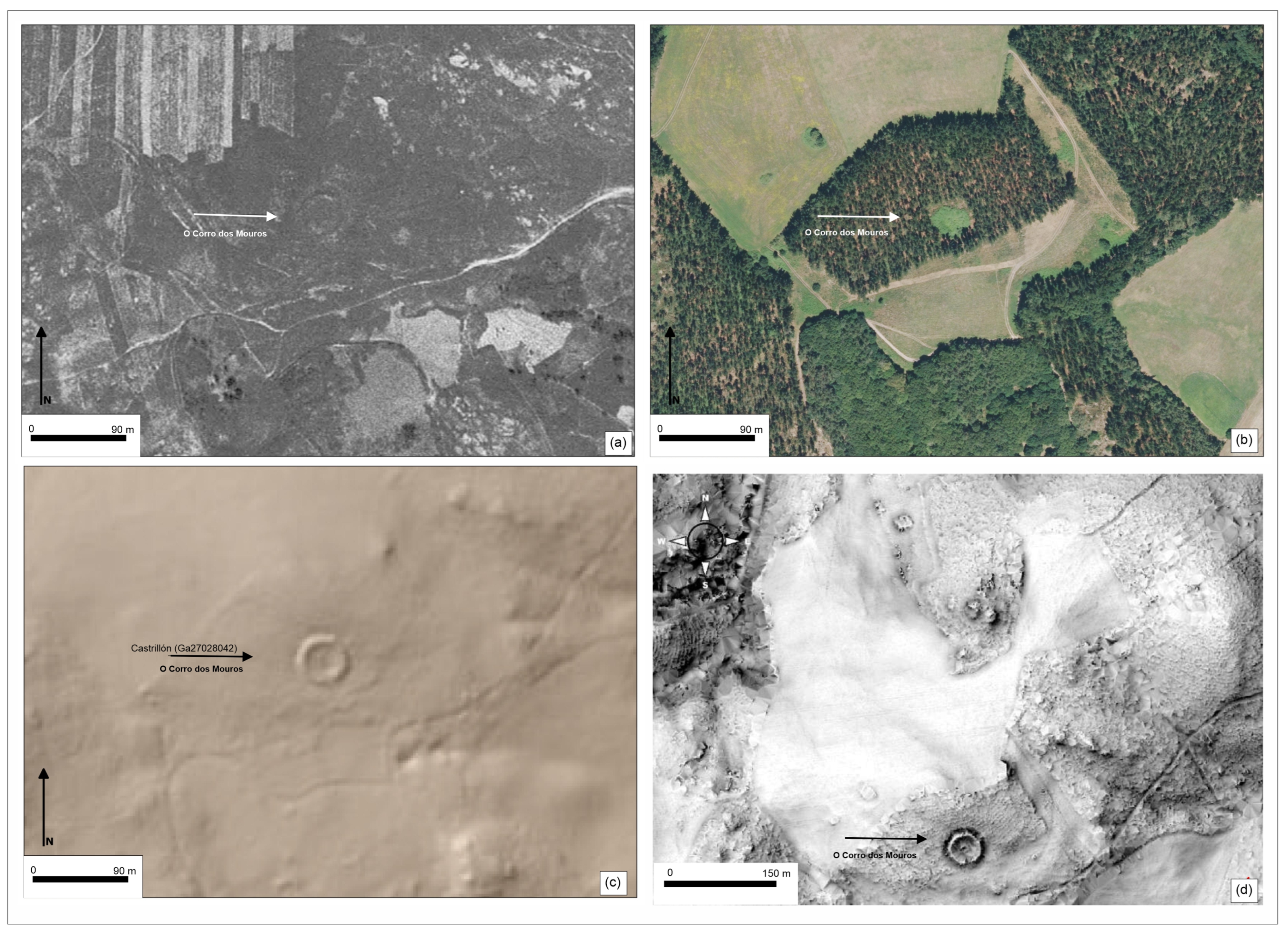
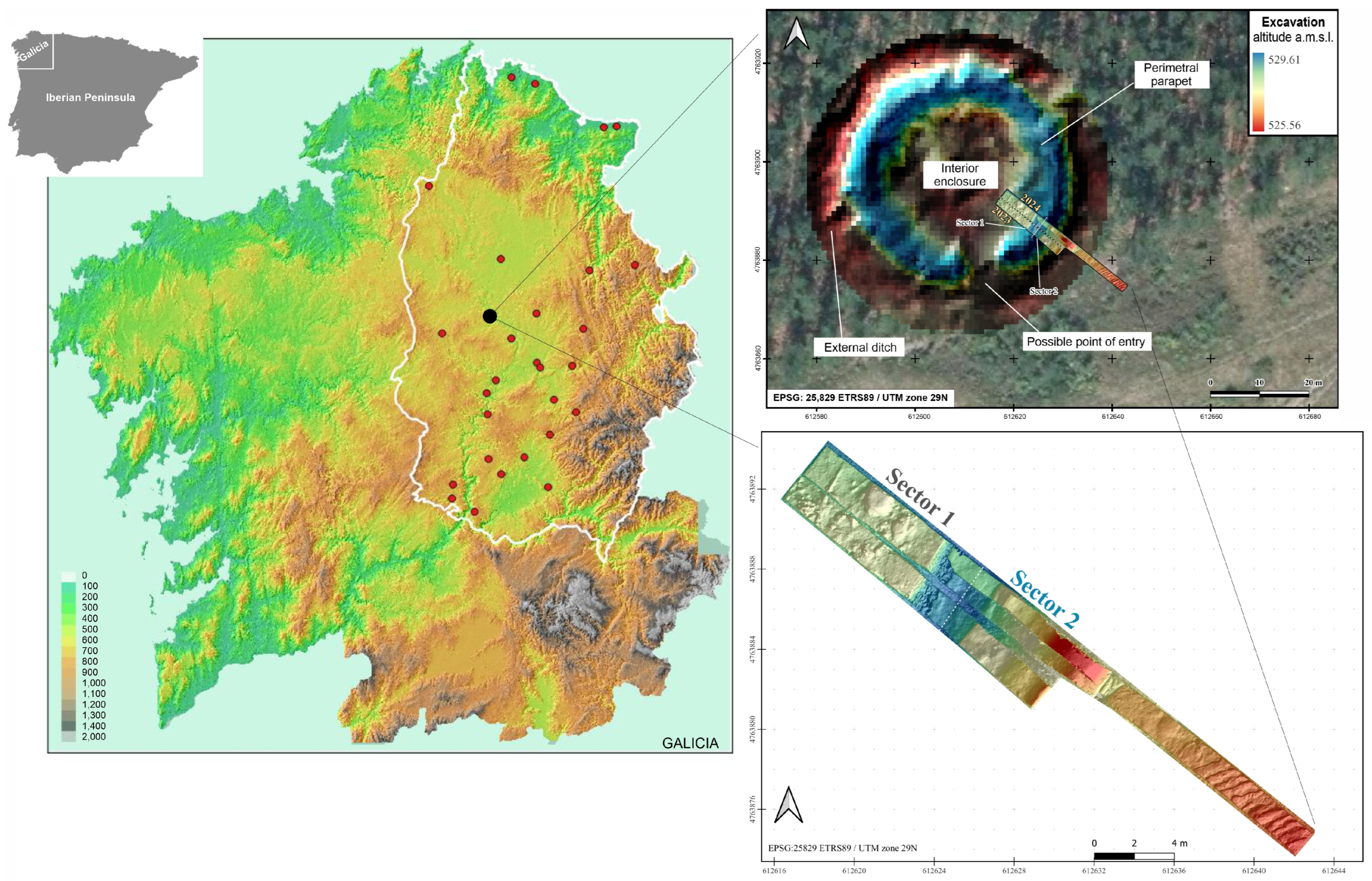
2.1. The Choice of Site and Its Characteristics

This set of digital technologies has been combined to obtain a product of scientific dissemination of interest to the general public and specialists, and this means that the final work is not just a technical report but a material designed to share knowledge with broad audiences. As an example, we have chosen a specific archaeological site, O Corro dos Mouros (OCM) and its immediate surroundings, a ritual landscape where research has recently begun, and which has proved to be a perfect experimental laboratory for the application of the digital technologies just mentioned.
O Corro dos Mouros is an archaeological site located in Galicia (parish of Santa María Madalena de Adai), in the central-western part of the municipality of Lugo, on the Monte de Penas del Caldeiro-Adai and close to the Miño River (Figure 1). This site has been excavated in 2023 and 2024. The 2023 excavation was funded by the USC (University of Santiago de Compostela), and the 2024 excavation was funded by the Xunta de Galicia.
The typology of this site is new to the region, called tipo-Roda (Figure 2). Roda means wheel in Galician language, this is the toponym more frequent for these places and indeed its shape is seen from the air as a wheel, an image that is quite easy to identify. It should be understood as a new monumental architecture emerging within a general funerary context, recently synthesised for the Middle and Late Bronze Age in Galicia [26], in which the architecture known up to now is characterised by isolated burials (cists and pits) invisible in the landscape, and the reuse of megaliths from the previous Neolithic period.
Research into this type of site is still in its infancy but it promises very interesting results that will contribute to significantly expanding and changing our knowledge of the region between the end of the second millennium and the end of the first millennium BC, that is, from the Late Bronze Age to the end of Second Iron Age.
Preliminarily, a Roda is a circular-shaped archaeological site delimited by monumental stone-made architecture and a ditch, hosting inside burials and other structures so far possibly associated with funeral rituals. These places could be considered a necropolis for the death (inside the circle) and meeting places for the living (outside). Its chronology varies between the 15th and 3rd centuries BC. Rodas are archaeological sites mainly, not exclusively, linked to funerary or/and ritual functions. There are currently eight Roda-type sites excavated in Galicia [27].
In particular, the architecture of O Corro dos Mouros is among the best-preserved sites. From a chronological perspective, six dates have been obtained. Two place the site’s construction and use between 13th and 11th centuries BC cal. Four align with the 8th–6th centuries BC cal, indicating a continuity of use over several centuries. From the material point of view, the O Corro dos Mouros excavation has yielded 3300 artefacts, currently in the study phase. This represents a density of 66 finds/m2, a remarkable figure when compared to Ventosiños site (another nearby site located a few kilometres away from OCM to the east of the Miño River), where 1946 artefacts were recovered from 7000 m2, resulting in a density much lower than OCM of only 0.27 finds/m2.
In terms of artefacts, there is evidence of intensive occupation, with around two hundred vessels (based on 2296 ceramic fragments) and 546 lithic artefacts, most of which are associated with grinding and crushing food, wall bonds or ritual objects such as slate and soapstone discs. These pieces were selected from a very wide range of materials from these periods. In the early phase, there are vessels and flat slabs placed on the ground near the parapet inside the enclosure. In the first millennium, the ritual of depositing some containers accompanied by discs associated with later dates continued, as well as a large pit sealed by a small menhir. The distribution is widespread throughout the excavated area, although it is more frequent inside the enclosure than on the outer structures of the parapet and ditch. Apparently, the function of the site has remained similar over time.
OCM is in Penas do Caldeiro-Adai, a strategically positioned site, which is on elevated terrain overlooking a vast surrounding landscape. Within a 1 km2 there are five rocks featuring rock art and four megalithic barrows, creating a cohesive cultural space. Within this cultural homogeneus context, Pena Fita is the unique example in Europe of a longhouse carved into the rock with a shelter. Expanding the radius to 3 km2, the territory encompasses four tumuli and the excavated hillfort of Penarrubia, dated to the First Iron Age, among other sites. The city of Lugo is visible across the river Miño, at the junction of the XIX and XX Roman roads. The area has been interpreted provisionally as a sanctuary of cultual and spiritual significant [28]. We are currently awaiting the results of four further dating analyses and the first results of sediment analysis from the site, funded by the Palarq 2024 Foundation (Cod. USC: 2024-PO019). In addition, we hope to expand our knowledge of the site and refine our interpretation during the next excavation scheduled for July 2025. With three excavation campaigns and the results of radiocarbon, soil and artefact analyses, we will be able to reconstruct a more accurate picture of the site and its function.
The general hypothesis we propose is that this type of site is in fact a necropolis, in line with [29], but its function is not exclusively funerary. We believe that Rodas are primarily spatial landmarks that politically and socially structure the territory. Places where communities buried their dead and visited periodically. They could also have been gathering spaces for different communities, meeting cyclically to strengthen ties, exchange ideas, goods, and people [30,31]. Rodas were important hubs for communication between nearby and distant villages, where interaction left material traces resembling sporadic domestic activity that may obscure the true function of the site: spaces for social, economic, and political exchange. Thus, alongside burial pits, we often find material culture both inside and outside the site that appears to be domestic but may have had deeper ritual or symbolic significance.
Figure 2. (a) US flight (1956_1_2000), (b) Google orthoimage (pnoa2017_1_2000), (c) Public LiDAR image, (d) 3D model of O Corro dos Mouros. The black and white arrows indicate the location of the O Corro dos Mouros site [30,31].
Applsci 15 06025 g002
The excavation data and study of adjacent archaeological sites support a territorial approach that interprets the landscape through both its physical and symbolic dimensions. This paper presents the key methodological tools employed to analyse this cultural territory and effectively communicate its heritage values.

2.2. Flowchart of the Process

Figure 3 presents the methodological workflow followed for the acquisition, processing, and dissemination of the data used in this study.
To standardize terminology across disciplines, critical terms are defined in the Supplementary Materials (Glossary S1). This ensures consistent interpretation of the site’s architecture and digital workflows.

2.3. Fusion of LiDAR-UAV and SfM Photogrammetry for High-Resolution 3D Archaeological Documentation

The archaeological site was documented using a combined approach of aerial SfM-MVS and UAV-LiDAR, complementary techniques where the former provides photorealistic textures while the latter delivers precise geometric data beneath vegetation. In simple terms, this means that buried structures can now be detected even through dense forest cover with centimetre-level precision. This integration through 3D registration produces models with centimetre-level accuracy and high visual detail.
The fieldwork commenced with a georeferencing phase, implementing a minimal-intervention protocol to preserve the archaeological context. Rather than using conventional artificial markers, we established a network of 28 natural ground control points (GCPs) based on landscape features, such as distinctive rock outcrops and stable geomorphological elements, strategically distributed to ensure optimal coverage of the site and its immediate surroundings. Georeferencing was performed using a Stonex S900T GNSS receiver (Stonex Srl, Monza, Italy).
For data acquisition, we employed a DJI Matrice 300 RTK UAV (Dà-Jiāng Innovations Science and Technology Co., Ltd., Shenzhen, China) equipped with real-time kinematic positioning (RTK-GNSS), guaranteeing 1.0–1.5 cm accuracy (±1 ppm, or parts per million) under optimal conditions. This professional quadcopter features an aerodynamic design with an optimised centre of gravity and a critical redundancy system, including three parallel inertial measurement units (IMUs), three independent barometers, and two compasses, ensuring operational continuity in case of component failure.
The UAV was equipped with a Zenmuse L1 sensor (Dà-Jiāng Innovations Science and Technology Co., Ltd., Shenzhen, China), combining a LiDAR module with a 20.4 MP RGB camera (1” CMOS sensor) capable of simultaneous high-precision geospatial data capture (±5 cm with RTK) and high-resolution imaging (5472 × 3648 pixels). The optical configuration includes a 3-axis stabilised gimbal (±0.01°), an 8.8 mm lens (24 mm equivalent) with a f/2.8 aperture, optimised for variable lighting conditions (ISO 100-6400, shutter speed 1/8000 s–8 s). This technological solution proves particularly effective in dense vegetation environments where conventional photogrammetric systems face limitations.
LiDAR data were processed in DJI Terra v4.0.10 (Dà-Jiāng Innovations Science and Technology Co., Ltd., Shenzhen, China) to generate classified 3D models with centimetre precision, while the RGB images, enhanced with EXIF metadata and RTK coordinates (±1 cm), were processed using SfM-MVS techniques in Agisoft Metashape v2.0.3.
The SfM-MVS workflow was executed in three main stages. First, the internal and external camera orientations were calculated, generating a georeferenced sparse point cloud that established the fundamental geometry of the dataset. Second, a dense point cloud was generated, significantly improving the spatial resolution and point density. Both phases were carried out with high-quality processing parameters to take full advantage of the original image resolution, thus ensuring optimal photogrammetric accuracy in the 3D reconstruction. Finally, a triangulated mesh was derived from the dense point cloud and textured using high-resolution RGB images.
As part of the LiDAR data processing workflow, noise filtering and advanced point cloud classification techniques were applied to remove irrelevant points and automatically distinguish vegetation from ground surfaces. This process greatly enhances the accuracy of the point cloud, enabling a clearer and more precise identification of underlying archaeological features. A high-resolution LiDAR system was employed to improve terrain representation and reduce the interference caused by vegetation. Although UAV-LiDAR has some limitations in areas with dense canopy, the synergistic integration with Structure from Motion photogrammetry effectively overcomes these challenges. This combined approach harnesses the complementary strengths of both technologies, merging LiDAR’s ability to penetrate vegetation with photogrammetry’s high-resolution texture capture, to produce more accurate and detailed reconstructions of terrain and archaeological features. In simple terms, LiDAR “sees through” vegetation, while photogrammetry adds realistic textures, combining the best of both technologies.
The resulting three-dimensional product was generated by merging two complementary datasets: (1) an automatically classified LiDAR point cloud providing precise terrain geometry (Figure 4a), and (2) high-resolution RGB textures acquired through SfM-MVS photogrammetry (Figure 4b).
For results dissemination, we developed an integrated set of digital products including: (1) a 3D model displaying current vegetation cover; (2) a vegetation-free version revealing underlying archaeological features; (3) an interpolated animation transitioning between both states; and (4) a 3D model of the integrated excavation area. The 3D models were optimised for Sketchfab visualisation through mesh reduction (retaining at least 1.7 million polygons) while preserving ultra-high-resolution JPG textures (4 textures at 8000 × 8000 pixels), implementing this selective optimisation strategy specifically to comply with Sketchfab’s free version 100 MB file size limit. The published models incorporate detailed annotations documenting both significant archaeological sites in the study area and the main research subject, resulting in photorealistic three-dimensional representations that enable precise spatial analysis of the site’s relationship with its surrounding environment.

3. Results

The results obtained from the case study are presented below.

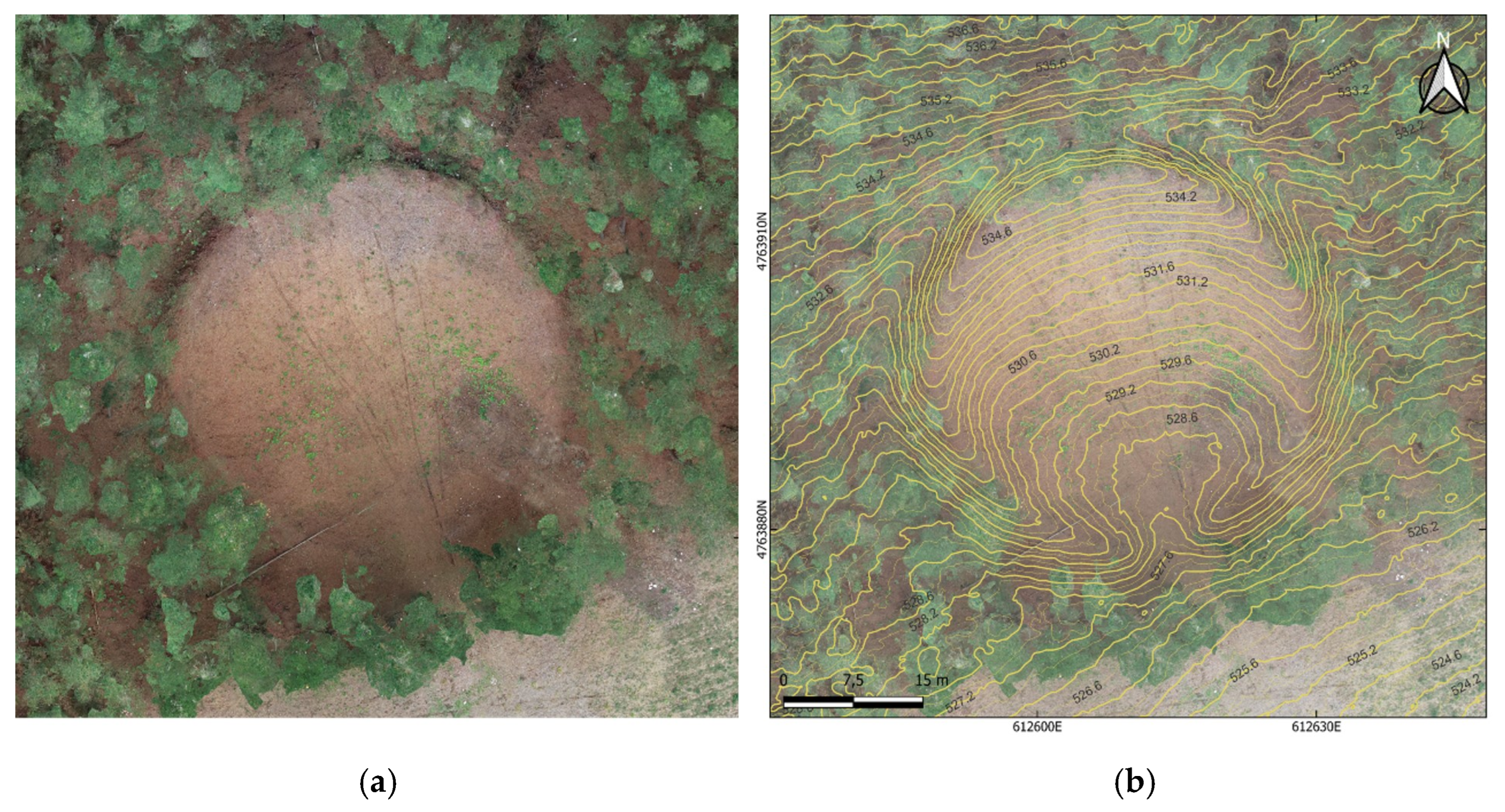
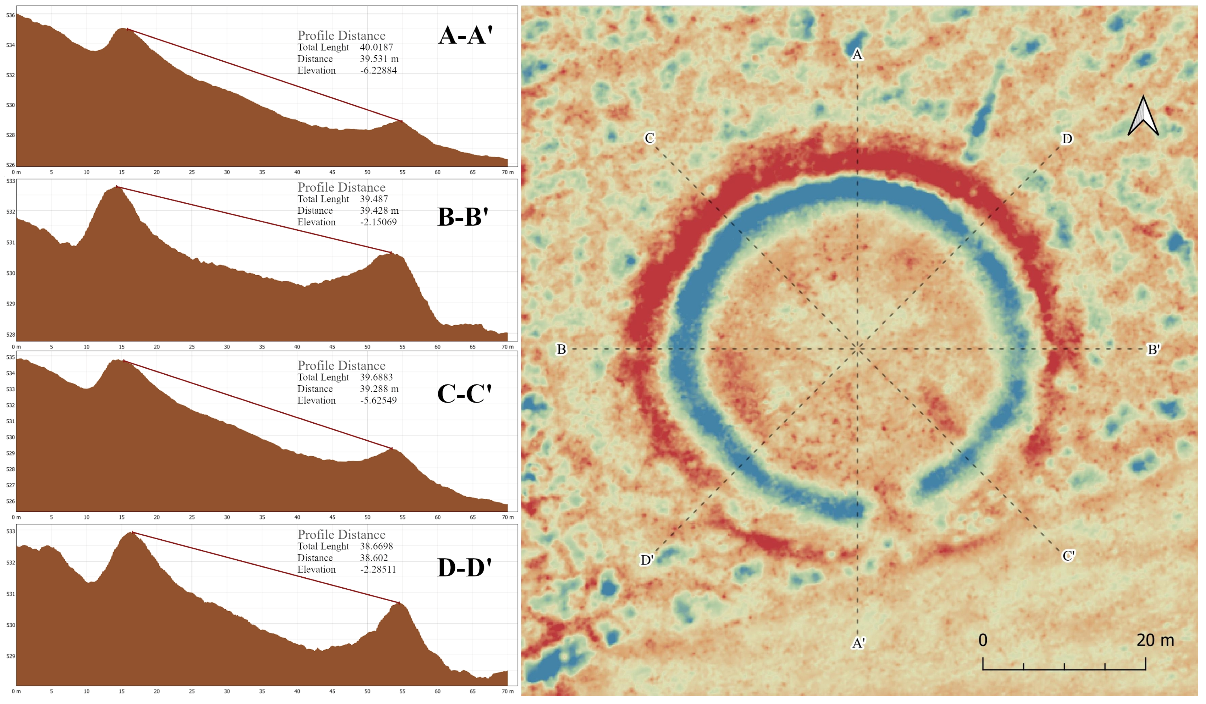
3.1. LiDAR and Photogrammetric Fusion: Data Visualisation and Terrain Modelling

Figure 5 shows the vegetation cover documented through LiDAR-SfM photogrammetry fusion (Figure 5a), while Figure 5b displays the Corro dos Mouros site after LiDAR processing with vegetation removal, where the archaeological structures are clearly visible.
Figure 6 displays the photogrammetric outputs, contrasting the high-resolution (2 cm/pixel) aerial orthophoto with its contour line-integrated version.
The implementation of LiDAR-UAV technology with ±5 cm geospatial accuracy represents a significant advancement over conventional public-domain LiDAR datasets limited to 1 m/pixel resolution. This enhanced capability manifests in two critical analytical dimensions (Figure 7): (1) precise quantification of site morphology, particularly the circular architectural pattern, which cannot be reliably characterised using lower-resolution datasets; and (2) improved feature discrimination through enhanced point cloud density (average 150 points/m2 vs. 1–5 points/m2 in public data), enabling superior post-excavation feature identification.
A perfect circle is visible (Figure 7), in which only 1.5 m of difference has been detected at the top of the parapet between axis A (40.01 m) and D (38.66 m). This metric difference would be difficult to measure accurately without this resource. This ‘perfect’ enclosure constructed on a complicated topography with an irregular slope shows us that this Late Bronze Age community had a deep knowledge of architecture and could solve technical difficulties on a slope that had been consciously selected (see the location patterns of these sites in [27]. Furthermore, in the image in Figure 7, the improvement in the visibility of the model with the LiDAR applied in the first year of excavation is evident (incorporated in Figure 1 of this study).
Additionally, external topographic anomalies potentially associated with the site have been identified in its immediate surroundings (Figure 8), some of which were also detected through ground-penetrating radar [31]. These anomalies are indications of possible archaeological structures outside the enclosure, providing useful information for planning future excavations. In simple terms, this level of detail lets us see subtle features that would otherwise be missed.

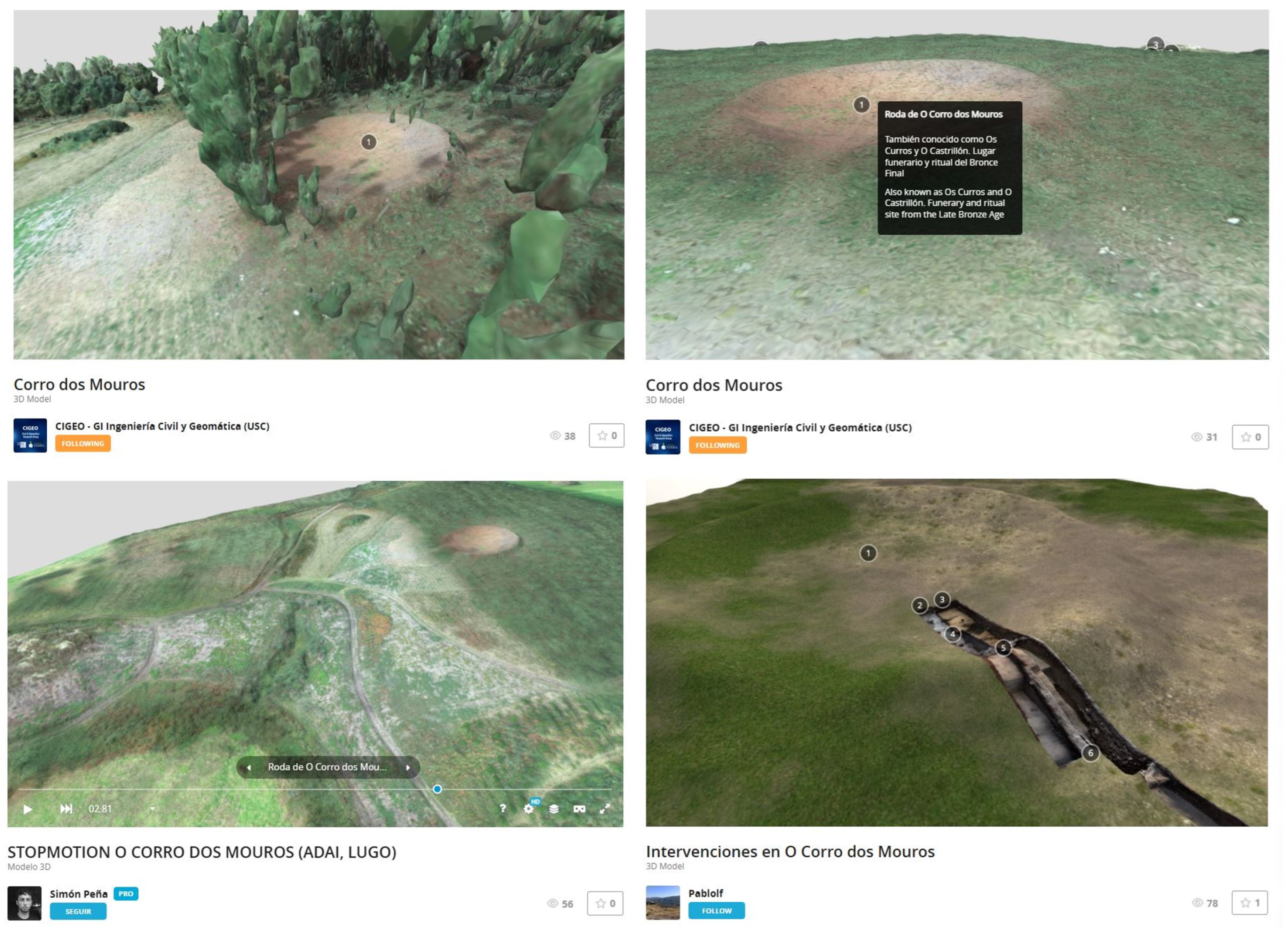
3.2. Online Publication

As an initial step, a high-resolution 3D model has been generated to accurately visualise the O Corro dos Mouros site and the surrounding archaeological corridor. This model integrates marked locations of visible sites within the immediate area, facilitating spatial analysis. Such reconstructions provide an effective means of representing complex landscapes in an accessible and informative manner.
A particularly valuable aspect of this approach is the ability to visualise the landscape both with and without vegetation, as this significantly alters spatial perception. The present tree cover results from a recent pine plantation and does not reflect the original vegetation present during the site’s construction and occupation.
The 3D models (Figure 9) are publicly available online. These include Corro dos Mouros—Vegetated State (https://skfb.ly/psqq8, accessed on 15 May 2025); Corro dos Mouros—Bare-Earth Surface (https://skfb.ly/psqqp, accessed on 15 May 2025); Corro dos Mouros—Vegetation-to-Archaeology Transition (https://skfb.ly/pwDWv, accessed on 15 May 2025); and Corro dos Mouros—Photogrammetry of the Integrated Excavation Area (https://skfb.ly/pvzrB, accessed on 15 May 2025).

4. Discussion

The combination of UAV-LiDAR and SfM photogrammetry technologies implemented at O Corro dos Mouros involves certain technical and operational limitations that must be taken into account. The precision of data acquisition through UAS is conditioned by meteorological factors, particularly visibility and atmospheric stability. In this case, the climatic variability characteristic of autumn in the northwest of the Iberian Peninsula forced adjustments to the flight planning, optimising the operational windows based on the most favourable conditions to ensure adequate resolution and geometric accuracy. One of the key factors influencing the results was vegetation, especially in areas with dense forest cover. Although the campaign was conducted during a season with less vegetation than summer, the presence of coniferous forests with persistent foliage represented a significant challenge for obtaining accurate data. In regions with tall trees and/or dense foliage, dense vegetation obstructed LiDAR laser penetration, resulting in incomplete terrain point clouds.
The processing of data obtained through photogrammetric techniques or LiDAR scanning requires the use of specialised software with advanced capabilities for 3D modelling, image alignment, and the generation of dense point clouds. Established commercial solutions such as Agisoft Metashape or DJI Terra provide high-precision results, but their acquisition represents a considerable economic investment (Table 1). It is important to note that the costs presented in Table 1 are approximate and may vary depending on factors such as geographic region, vendor, license type (e.g., perpetual, subscription-based, or floating), and other commercial conditions, which may exceed the budget capacity of many archaeological projects or research groups with limited resources. Although the choice of these commercial platforms was justified based on their advanced capabilities and the need to ensure high fidelity in the generated products, it is worth noting that open-source solutions such as Meshroom, despite their limitations in terms of metric accuracy, process automation, and technical support, can constitute viable alternatives in budget-constrained environments. Additionally, access to shared academic or institutional licences represents an effective strategy to increase the availability of these tools in research contexts with limited resources.

5. Conclusions and Perspectives

The methodologies applied in this study have proven remarkably flexible, allowing for modular and scalable information integration tailored to research needs. This innovative approach not only facilitates didactic visualisation of the ritual landscape but also enables progressive incorporation of data at varying complexity levels, from specific analytical results like radiocarbon dating, soil geochemical studies, or vegetation and lithology analyses, to diverse graphic materials including photographs, archaeological drawings, toponymic documentation, or detailed descriptions of the site’s most relevant features.
This work represents the first regional initiative that effectively combines accessible dissemination with scientific rigour through advanced digital technologies, demonstrating its tremendous potential to reach diverse audiences ranging from specialists to the heritage-interested general public. Archaeological documentation supported by these digital tools gains particular relevance not only as a method for digital preservation of these sites but also as a monitoring system to assess their evolution against natural or anthropogenic changes. In this regard, the parallel work by Archaeology, Antiquity, and Territory Research Group (AATRG) at the University of Vigo in the Atlantic Islands [32] serves as an illustrative example, where similar methodologies are employed to evaluate coastal impact on archaeological heritage, demonstrating the versatility of these techniques.
The integration of LiDAR with photogrammetry technologies has revealed exceptional value, both from dissemination and scientific application perspectives. This methodological combination allows precise assessment of archaeological interventions’ impact on the site while providing a solid foundation for developing virtual reconstructions directly linked to results interpretation. Furthermore, it offers the unique capability to immediately compare the site’s current morphology with its documented state in previous phases, thus creating a diachronic record of great scientific value.
As future development, extending this detailed recording system to all surrounding sites after their excavation or archaeological clearance has been established as a priority objective. Particularly promising is the application of these techniques to petroglyph studies, where their precise documentation capacity could open new research avenues. Ultimately, this project establishes the foundations for a new paradigm in heritage documentation, more dynamic, accessible, and resilient, that not only preserves the past with maximum fidelity but effectively connects it with current and future needs of research, management, and cultural heritage dissemination. Beyond its academic value, these methodologies emerge as tools of heritage justice, ensuring that cultural legacy (particularly the most vulnerable or peripheral) becomes preserved, understood, and appreciated by present and future generations. The success of this approach at O Corro dos Mouros opens a path that can be replicated for other archaeological sites awaiting similar in-depth study.

Supplementary Materials

The following supporting information can be downloaded at: https://www.mdpi.com/article/10.3390/app15116025/s1, Glossary S1: Glossary of Terms.

Author Contributions

Conceptualization, S.P.-V.; Methodology, M.G.-D., S.P.-V. and J.O.-S.; Validation, M.G.-D. and S.P.-V.; Formal analysis, M.P.P.-M.; Investigation, R.L.-J. and S.P.-V.; Resources, R.L.-J. and P.L.-F.; Data curation, R.L.-J. and P.L.-F.; Writing—original draft, R.L.-J. and M.P.P.-M.; Writing—review & editing, M.G.-D., R.L.-J. and M.P.P.-M.; Visualization, R.L.-J., P.L.-F. and S.P.-V.; Supervision, M.G.-D., S.P.-V., J.O.-S. and M.P.P.-M.; Project administration, M.G.-D. and M.P.P.-M.; Funding acquisition, M.G.-D. and M.P.P.-M. All authors have read and agreed to the published version of the manuscript.

Funding

This research was funded by [Department of Culture, Language and Youth of Xunta de Galicia] grant number [CT 102A 2024/324-0 (File: Archaeology Service: 02.L.566.2024.001)] with partial support from the European Commission through the POCTEP-INTERREG program [grant 0054_AEROGANP_1_E].

Institutional Review Board Statement

Not applicable.

Data Availability Statement

The 3D models are publicly available online: Corro dos Mouros—Vegetated State: https://sketchfab.com/3d-models/corro-dos-mouros-afb860d6fd5841a39a2aadb97a56357e (accessed on 15 May 2025); Corro dos Mouros—Bare-Earth Surface: https://sketchfab.com/3d-models/corro-dos-mouros-35f51b154dcc481f86c6708e297705d0 (accessed on 15 May 2025); Corro dos Mouros—Vegetation-to-Archaeology Transition: https://sketchfab.com/3d-models/stopmotion-o-corro-dos-mouros-adai-lugo-aa6218ceb1e74090b057f35f6d6405f6 (accessed on 15 May 2025); Corro dos Mouros—Photogrammetry of the integrated excavation area: https://sketchfab.com/3d-models/intervenciones-en-o-corro-dos-mouros-8d0a565df3a74c3d80b97f9bf73bb6fb (accessed on 15 May 2025).

Acknowledgments

The authors acknowledge the use of generative artificial intelligence tools, particularly ChatGPT-3.5 developed by OpenAI, as a writing assistant to improve the clarity of the manuscript. All content was reviewed and approved by the authors.

Conflicts of Interest

The authors declare no conflict of interest.

References

  1. Staropoli, L.; Acevedo, V.J.; Ávido, D.N.; Vitores, M. Reflexiones En La Práctica de La Arqueología Digital: La Construcción y Comunicación Del Patrimonio Cultural Virtual. Virtual Archaeol. Rev. 2023, 14, 118–135. [Google Scholar] [CrossRef]
  2. García-Molina, D.F.; González-Merino, R.; Rodero-Pérez, J.; Carrasco-Hurtado, B. Documentación 3D Para La Conservación Del Patrimonio Histórico: El Castillo de Priego de Córdoba. Virtual Archaeol. Rev. 2021, 12, 115. [Google Scholar] [CrossRef]
  3. Sokol, O.L.; Salerno, V. Bienes “Públicos” y Lo Digital En La Arqueología Argentina. Rev. Mus. Antropol. 2023, 16, 363–376. [Google Scholar] [CrossRef]
  4. Roteta Lannes, C.; Pupio, M.A.; Mazzia, N. La Fotogrametría En Las Estrategias de Comunicación: Análisis Del Uso de Modelos 3D En La Arqueología Bonaerense. Rev. Mus. Antropol. 2024, 17, 331–346. [Google Scholar] [CrossRef]
  5. Laurent, A.; Coupry, B.; Brument, B.; Mélou, J.; Quéau, Y.; Fritz, C.; Durou, J.-D. Combining Geometric and Photometric 3D Reconstruction Techniques for Cultural Heritage. J. Cult. Herit. 2025, 73, 43–51. [Google Scholar] [CrossRef]
  6. Schroder, W.; Murtha, T.; Golden, C.; Scherer, A.K.; Broadbent, E.N.; Almeyda Zambrano, A.M.; Herndon, K.; Griffin, R. UAV LiDAR Survey for Archaeological Documentation in Chiapas, Mexico. Remote Sens. 2021, 13, 4731. [Google Scholar] [CrossRef]
  7. Aldrighettoni, J.; D’Urso, M.G. Military Archaeology and LIDAR Data Visualizations: A Non-Invasive Approach to Detect Historical Remains. Acta IMEKO 2023, 12, 1–10. [Google Scholar] [CrossRef]
  8. Mascort-Albea, E.J.; Ruiz Jaramillo, J.; Romero-Hernández, R. Analizando El Patrimonio Cultural a Través de Vuelos No Tripulados: Nuevas Estrategias de Investigación de Espacios Rurales y Urbanos. Virtual Archaeol. Rev. 2014, 5, 55. [Google Scholar] [CrossRef]
  9. Mészáros, J. Aerial Surveying Uav Based on Open-Source Hardware and Software. Int. Arch. Photogramm. Remote Sens. Spat. Inf. Sci. 2012, 38, 155–159. [Google Scholar] [CrossRef]
  10. Cruz Franco, P.A.; de la Rueda Márquez Plata, A.; Pérez Sendín, M. Investigating a Workflow for Obtaining Physical Models from Digital Twins Obtained through Photogrammetry and TLS: New Ways for a Sustainable Dissemination of Heritage. Appl. Sci. 2023, 13, 1057. [Google Scholar] [CrossRef]
  11. Peña-Villasenín, S.; Gil-Docampo, M.; Ortiz-Sanz, J. Professional SfM and TLS vs. a Simple SfM Photogrammetry for 3D Modelling of Rock Art and Radiance Scaling Shading in Engraving Detection. J. Cult. Herit. 2019, 37, 238–246. [Google Scholar] [CrossRef]
  12. Guarnieri, A.; Remondino, F.; Vettore, A. Digital Photogrammetry and Tls Data Fusion Applied to Cultural Heritage 3D Modeling. Int. Arch. Photogramm. Remote Sens. Spat. Inf. Sci. 2006, 36, 1–6. [Google Scholar]
  13. Lorenzo, G.; López, L.; Moralejo, R.A.; del Papa, L.M. SfM Photogrammetry Applied to Taxonomic Determination of Archaeofauna Remains. Virtual Archaeol. Rev. 2019, 10, 70–83. [Google Scholar] [CrossRef]
  14. García Lerena, M.S.; López, L. Relevamiento Del Patrimonio Histórico Rural Mediante Fotogrametría (SfM-MVS) En La Región Pampeana Argentina. “Primera Estancia” de Magdalena (Buenos Aires, Argentina). Arqueología 2021, 27, 169–181. [Google Scholar] [CrossRef]
  15. Gil-Docampo, M.; Peña-Villasenín, S.; Bettencourt, A.M.S.; Ortiz-Sanz, J.; Peraleda-Vázquez, S. 3D Geometric Survey of Cultural Heritage by UAV in Inaccessible Coastal or Shallow Aquatic Environments. Archaeol. Prospect. 2023, 32, 19–34. [Google Scholar] [CrossRef]
  16. Peña Villasenín, S. Aplicaciones de La Fotogrametría de Bajo Coste al Estudio de Patrimonio Arqueológico y Arquitectónico. Ph.D. Thesis, Universidade de Santiago de Compostela, A Coruña, Spain, 2019. [Google Scholar]
  17. Wilkinson, M.W.; Jones, R.R.; Woods, C.E.; Gilment, S.R.; McCaffrey, K.J.W.; Kokkalas, S.; Long, J.J. A Comparison of Terrestrial Laser Scanning and Structure-from-Motion Photogrammetry as Methods for Digital Outcrop Acquisition. Geosphere 2016, 12, 1865–1880. [Google Scholar] [CrossRef]
  18. Herrero, M.J.; Pérez-Fortes, A.P.; Escavy, J.I.; Insua-Arévalo, J.M.; De la Horra, R.; López-Acevedo, F.; Trigos, L. 3D Model Generated from UAV Photogrammetry and Semi-Automated Rock Mass Characterization. Comput. Geosci. 2022, 163, 105121. [Google Scholar] [CrossRef]
  19. Li, Z. New Opportunities for Archaeological Research in the Greater Ghingan Range, China: Application of UAV LiDAR in the Archaeological Survey of the Shenshan Mountain. J. Archaeol. Sci. Rep. 2023, 51, 104182. [Google Scholar] [CrossRef]
  20. Guo, Q.; Su, Y.; Hu, T.; Zhao, X.; Wu, F.; Li, Y.; Liu, J.; Chen, L.; Xu, G.; Lin, G.; et al. An Integrated UAV-Borne Lidar System for 3D Habitat Mapping in Three Forest Ecosystems across China. Int. J. Remote Sens. 2017, 38, 2954–2972. [Google Scholar] [CrossRef]
  21. Filip-Gherman, M.; Bruma, S.; Sabou, C.; Nap, M.; Suba, E.-E.; Sălăgean, T. The Cross-Disciplinary Influence of Aerial Measurement Techniques: Exploring Archaeological Studies through Photogrammetry and LiDAR. Nova Geod. 2024, 4, 154. [Google Scholar] [CrossRef]
  22. Quintilla Castan, M.; Agustín-Hernández, L. Los Sistemas de Documentación Como Instrumento de Conservación Del Patrimonio Arquitectónico. Experiencias En España y Europa. Erph Rev. Electrón. Patrim. Hist. 2023, 41–75. [Google Scholar] [CrossRef]
  23. Marín-Buzón, C.; Pérez-Romero, A.M.; León-Bonillo, M.J.; Martínez-Álvarez, R.; Mejías-García, J.C.; Manzano-Agugliaro, F. Photogrammetry (SfM) vs. Terrestrial Laser Scanning (TLS) for Archaeological Excavations: Mosaic of Cantillana (Spain) as a Case Study. Appl. Sci. 2021, 11, 11994. [Google Scholar] [CrossRef]
  24. Rodríguez-Bulnes, J. LIDAR XXI: Técnicas Topográficas Del Siglo XXI Aplicadas a La Detección de Yacimientos Arqueológicos Ocultos Por Vegetación. LIDAR XXI: Topographic Techniques of the XXI Century Applied to the Detection of Archaeological Sites Hidden by Vegetation. UNES Univ. Esc. Y Soc. 2023, 16, 171–185. [Google Scholar] [CrossRef]
  25. Tobalina Pulido, L.; Polo Romero, L.A.; Suárez López, P.A. La Necrópolis de Santa Ana (Guzmán, Burgos). Localización y Caracterización Mediante Prospección Superficial. Arqueol. Y Territ. Mediev. 2025, 32, e9051. [Google Scholar] [CrossRef]
  26. Nonat, L.; Prieto Martinez, M.P.; Vazquez Liz, P. Les contextes funéraires et le dynamisme culturel du nord-ouest de la péninsule Ibérique entre le XVIIIE siècle et le VIIIE siècle avant J.-C. In Funerary Practices in the Second Half of the Second Millennium BC in Continental Atlantic Europe. From Belgium to the North of Portugal; Nonat, E.L., Prieto, P., Eds.; Archaeopress Archaeology: Oxford, UK, 2022; pp. 128–156. [Google Scholar]
  27. Prieto Martínez, M.P.; Cordeiro Maañón, L. Ritual sites from the Second Millennium BC in the North West of Spain. In Funerary Practices in the Second Half of the Second Millennium BC in Continental Atlantic Europe: From Belgium to the North of Portugal; Nonat, E.L., Prieto, P., Eds.; Archaeopress Archaeology: Oxford, UK, 2022; pp. 187–199. [Google Scholar]
  28. Vázquez Liz, P.; Prieto-Martínez, M.P.; Núñez Jato, J.F. El pasado olvidado: El sitio del II y I milenio BC de Pena Fita (Adai, Lugo) en el contexto de las ‘longhouses’ del NW peninsular. Gallaecia 2015, 34, 9–56. [Google Scholar] [CrossRef]
  29. Cano Pan, J.A.; Piay Augusto, D.; Naveiro López, J.L. Un Yacimiento Ceremonial en la Transición del Bronce al Hierro: Ventosiños (Coeses, Lugo); Arqueoloxia do Noroeste SLU: Cambre, Spain, 2015. [Google Scholar]
  30. Prieto Martínez, M.P. Actuación Arqueolóxica de Investigación e Documentación do Xacemento Arqueolóxico de Corro dos Mouros/O Castrillón/Os Curros—GA27028042—(Santa María Madalena de Adai, Lugo) Código SXPA: CT 102A 2023/653-0, Expte. S. Arqueoloxía: 02.L.566.2023.001; Unpublished Preliminary Report; Xunta de Galicia: A Coruña, Spain, 2023.
  31. Prieto Martínez, M.P. Actuación Arqueolóxica de Investigación e Documentación do Xacemento Arqueolóxico de Corro dos Mouros/O Castrillón/Os Curros—GA27028042—(Santa María Madalena de Adai, Lugo). Código SXPA: CT 102A 2024/324-0, Expte. S. Arqueoloxía: 02.L.566.2024.001; Unpublished Report; Xunta de Galicia: A Coruña, Spain, 2024.
  32. Valle Abad, P.; Lago Cerviño, M.; Ruanova Álvarez, N.; Arqueóloga, A.; Fernández Fernández, A. Proyecto SENTINELA. Técnicas y Procedimientos Para El Registro Del Patrimonio Cultural Inmueble. Minius 2024, 29. [Google Scholar] [CrossRef]
Figure 1. Distribution of identified ‘roda’ type sites in the province of Lugo (red dots). The location of O Corro dos Mouros (black dot) is indicated. Public LiDAR image modified to highlight relief and photogrammetry of the final phase of the 2023 and 2024 excavation.
Applsci 15 06025 g001
Figure 3. Workflow of the methodology implemented in this study.
Applsci 15 06025 g003
Figure 4. Detailed representation of O Corro dos Mouros. (a) Untextured 3D mesh model computed from classified UAV-LiDAR point cloud. (b) RGB-textured 3D reconstruction processed through SfM photogrammetry.
Applsci 15 06025 g004
Figure 5. Three-dimensional models derived from the integration of LiDAR and SfM photogrammetry technologies. (a) General overview of the study area. (b) Vegetation-free rendering of Corro dos Mouros, clearly visualising the underlying archaeological morphology.
Applsci 15 06025 g005
Figure 6. Corro dos Mouros: (a) High-resolution orthophoto (2 cm/pixel). (b) Same orthophoto overlaid with topographic contour lines (0.2 m interval).
Applsci 15 06025 g006
Figure 7. Topographic profiles of the O Corro dos Mouros site with the distances between the upper points of the parapet’s opposite sides on the left. The image on the right shows the site plan. The red colour corresponds to features in negative; for example, the outer perimeter circle is the ditch, while the blue colour represents structures or anomalies in positive or relief, and the inner blue circle is the parapet.
Applsci 15 06025 g007
Figure 8. Detection of archaeological anomalies using LiDAR technology in the immediate surroundings of Corro dos Mouros. The green arrow on the left indicates an anomaly detected by ground-penetrating radar. The yellow arrow on the right points to a possible destroyed burial mound (no geophysical survey has been conducted in that area yet). In Figure (a), the anomalies are indicated with arrows, while in Figure (b), the surface of the observed anomaly is also covered, clarifying the surface of the anomalies and allowing both images to be compared.
Applsci 15 06025 g008
Figure 9. 3D models of the O Corro dos Mouros archaeological site, developed as tools for archaeological analysis and interpretation, and intended to promote scientific study and public dissemination through accessible visualisations, available on the Sketchfab platform.
Applsci 15 06025 g009
Table 1. Processing costs.
SoftwareCosts ($)
Agisoft Metashape (Professional Edition)4.000
DJI Terra Pro5.000
Disclaimer/Publisher’s Note: The statements, opinions and data contained in all publications are solely those of the individual author(s) and contributor(s) and not of MDPI and/or the editor(s). MDPI and/or the editor(s) disclaim responsibility for any injury to people or property resulting from any ideas, methods, instructions or products referred to in the content.

