Article

Heritage in Danger: Digital Conservation and a Reserve for the Future of the Benzú Rock Shelter and Cave (Ceuta, Spain)

by
Alejandro Muñoz-Muñoz
1,
José Ramos-Muñoz
1,
Eduardo Vijande-Vila
1,
Juan Jesús Cantillo-Duarte
1,
José Luis Ramírez-Amador
2,
Salvador Domínguez-Bella
2,
Serafín Becerra-Martín
3,
Eduardo Molina-Piernas
2,* and
Diego Fernández-Sánchez
4
1
Department of History, Geography and Philosophy, University of Cádiz, 11003 Cádiz, Spain
2
UGEA-PHAM, Department of Earth Science, Universidad de Cádiz, 11519 Cádiz, Spain
3
Museo Histórico de Teba, 29327 Teba, Spain
4
Department of Prehistory, Ancient History and Archaeology, Complutense University of Madrid, 28040 Madrid, Spain
*
Author to whom correspondence should be addressed.
Appl. Sci. 2025, 15(11), 5893; https://doi.org/10.3390/app15115893
Submission received: 26 March 2025 / Revised: 19 May 2025 / Accepted: 22 May 2025 / Published: 23 May 2025
(This article belongs to the Special Issue Application of Digital Technology in Cultural Heritage)

Abstract

:
The archaeological complex of the Benzú rock shelter and cave, located in Ceuta (Spain), represents a heritage site of significant scientific and historical value that is currently at risk due to natural processes and, in particular, the activity of a nearby quarry. This site has been occupied from the Palaeolithic to the Bronze Age and consequently has been the subject of systematic research since 2002, focusing on its stratigraphic sequence, lithic technology, exploitation of marine resources, and the connection between both shores of the Strait of Gibraltar. With the aim of preserving this endangered heritage, a methodology based on advanced digital technologies such as photogrammetry, 3D laser scanning, and GNSS georeferencing has been implemented. These tools have enabled the creation of high-precision, three-dimensional models of the rock shelter and the cave, which are useful for both documentation and monitoring of their structural condition. In addition, fracture networks have been identified, revealing a high degree of geotechnical vulnerability, exacerbated by blasting activities at the nearby quarry. The project has produced a digital twin of the site in an open access format, serving not only for preventive conservation but also for its enhancement through virtual tours, augmented reality, and accessible outreach activities. This digitalization has been essential to facilitate the access to heritage, particularly in areas that are physically difficult to access. Finally, the integration of these digital resources into institutional policies for the sustainable management of heritage is proposed, highlighting the importance of interdisciplinary approaches that combine archaeology, geotechnology, and scientific communication. The experience at Benzú is presented as a replicable model for the protection, interpretation, and dissemination of heritage sites located in fragile and threatened environments.

1. Introduction

Every research project in prehistoric archaeology must combine basic research, conservation measures, and a dissemination–socialisation plan. Concerning preservation, although there is wide consensus concerning the need to protect items of historical heritage, we must be aware of clear trends that favour the preservation of some items over others, with an emphasis on monumental remains, and even of some archaeological periods over others [1,2,3,4,5,6]. All heritage should be considered socially valuable, and the recording and understanding of historical objects as the remains of human action in its natural environment must be regarded as a priority [7].
This is related to the meaning of archaeology. Why? For what purpose? And, for whom? The previous questions directly interrogate the theoretical stance adopted by every archaeological project [8,9]. In this way, heritage is understood as historic legacy, a product of a cultural and historical process on which our identity rests. We are interested in popularising historical heritage, and for that we need to understand what it means, reflecting on the ownership, exploitation, and enjoyment of this social asset [10]. Naturally, this leads to questions such as ‘what is that is being bequeathed?’ and ‘who has a say on what is bequeathed?’ We are convinced that heritage is historically, socially, and culturally contingent and must be turned into a cultural asset [10,11]. This demands a relational reading of archaeology as a product of history, as cultural heritage, which inevitably affects our views on valorisation. We need to shed off unidirectional approaches and accept that the collective perception of these assets is the result of historical and social processes [4,10,12].
One of the main fields of interest for our research team is the study of large caves with long archaeological sequences [13], as well as of small settlements of hunters–gatherers–fishers, rock shelters, small caves, and open-air settlements, and the everyday life of the prehistoric communities that inhabited them [14]. The digital techniques presented here intend to make the knowledge acquired by our research team available to society. This also includes requesting that preservation policies overcome the monumentalism of some management models, arguing for a heritage policy that integrates all records (rock shelters, small caves, villages, towns, huts, and archaeological finds…) in their territorial context to improve the everyday life of local communities [14]. To date, the socialisation and communication of research [15] has crystallised in public talks, open days, etc., in addition to standard dissemination through scientific publications. For this reason, the need to adopt a consistent approach to the three aspects of the archaeological process—research, preservation, and socialisation—is undeniable.
Our site is peculiar from an administrative point of view. The land is owned by the Spanish Ministry of Defence, which has to authorise all works. Although, in Spain, heritage matters have been devolved to regional governments, in this instance the authorisation depends on the Spanish Ministry of Culture. In the city of Ceuta, therefore, heritage policies follow the Historical Heritage Act (Ley 16/1985, de 25 de junio), which guarantees the involvement of the public administration in the protection of historical heritage from private interests. In this context, the Benzú rock shelter and cave was declared Bien de Interés Cultural (BIC, the maximum protection figure in Spain) in 2008, (B.O.E. 242, 7 October 2008, p. 40394). BICs are included in a list of movable and immovable items that are regarded as important from a heritage point of view, and this theoretically affords them a degree of protection. Among other things, BICs are considered in relation to their environment, which must also be protected by public bodies.
Despite this legal protection, the site of Benzú rock shelter and cave has been deteriorating owing to the activity of the quarry located in Mogote de Benzú, including the collapse of the front ceiling, falling blocks of rock downslope, and fissures. This is causing serious damage to the site, as well as putting the nearby village of Cabililla de Benzú at risk. In the past, the advance of the quarry caused the destruction of the neo-medieval fort de Benzú, situated at the top of the Mogote de Benzú and built to mark the border with Morocco after the Treaty of Wad Ras (1860), which brought the Hispano–Moroccan War to an end. The fort was built 1881 and 1884 [16], one of a series of nine forts constructed to defend the new border of Ceuta in the heights of Sierra de Bullones and the Anyera ravine, of which seven are preserved [17,18,19].
Our team has been researching the site since 2002, including several excavation and survey seasons [20,21,22]. The Benzú project involved a partnership between the University of Cádiz and the autonomous city of Ceuta. In 2013, the results of the first decade of research project were published [23], and further excavation seasons in 2014, 2015, and 2016 were undertaken in Cueva de Enrique, located in the upper section of the Mogote de Benzú and also affected by the quarry. Additional analyses have also been carried out in Benzú rock shelter and cave, and the materials were deposited in the Museum of Ceuta (over 50,000 archaeological items) in 2017. The project’s results have been published in books, more than thirty scientific articles, conferences, specialised meetings and seminars, and three doctoral dissertations (see publications on Benzú in: https://rodin.uca.es/handle/10498/21312). The following avenues of research have been pursued:
-
Quaternary geology (geomorphology and stratigraphy).
-
Archaeologically, ten strata were documented, seven of which yielded evidence of human activity during prehistory, although the natural cementation processes undergone by the sediments made excavation a daunting task [24,25]. The historical chronological sequence of the strata was established by means of absolute dating techniques (OSL, TL, U/Th, and C14).
-
Ecological reconstruction of the Pleistocene and Holocene environment; terrestrial fauna; marine fauna; birds; and plants (pollen, seed, anthracological, and phytolith analysis). This aimed to establish the relationship of human societies and their environment.
-
Origin and characterisation of the lithic raw materials used in the Benzú rock shelter and cave [20]. This is key for understanding resource supply systems and group mobility patterns.
-
Technological and functional analysis of stone tools (over 35,000 items), leading to the identification of Mode 3-MSA-Middle Palaeolithic in North Africa [21,23], an earlier chronology than hitherto recognised in the region.
-
Revision of traditional prehistoric narratives, taking a view from the south of the human colonisation of Europe during prehistory and the possible links between the two shores of the Strait of Gibraltar.
-
Review of the chronology of the Mode 3-Middle Palaeolithic, which has shown to be earlier than previously thought (300 Ka.).
-
Confirmation of the importance of marine resources for hunter-gatherers (over 150,000 years ago) [22].
-
Research at Benzú cavehas led to major new insights into the beginnings and developments of productive economic strategies. Two occupation horizons dated to the Early Neolithic and the Bronze Age were defined, probably in relation to the use of the cave as a shelter by shepherds and as a burial site, respectively [26].
-
Geostrategic importance of the geohistorical region of the Strait of Gibraltar.
All these avenues were pursued from an interdisciplinary perspective that has greatly contributed to a better understanding of human occupation and Quaternary lifestyles in the geohistorical region of the Strait of Gibraltar [27] (additional information can be found in https://rodin.uca.es/handle/10498/21312).
The main objective of this study is to produce an updated topographic record of the site using advanced three-dimensional digitization techniques. Based on this, three lines of action have been developed to assess the scope and effectiveness of the work carried out. First, the impact of 3D technologies on the study and documentation of archaeological spaces with difficult access, such as caves, has been evaluated. The methodology used is presented in detail, considering the technical and environmental factors that influenced the development of the project. Second, the resulting 3D model is proposed as an effective tool for monitoring the physical deterioration of the site, including the detection of fissures, collapses, or other structural alterations. This is intended to support the autonomous city of Ceuta in making informed decisions regarding preventive conservation and heritage management [28,29,30,31]. Third, the site is proposed for enhancement through public engagement initiatives developed around the Benzú site, which have consistently adhered to the highest standards of scientific rigour. Today, to increase the accessibility of an archaeological site involves a wide range of activities aimed at bringing knowledge closer to the general public, including outreach lectures, open days, specialised and popular publications, and the creation of interactive content. In this context, a new methodology is presented for the development of a virtual model of the site, which will allow for the future design of augmented reality tours and access on web-based repositories such as Sketchfab. This proposal is particularly relevant in spaces with difficult physical access as it opens the possibility of offering immersive experiences to individuals with reduced mobility. Furthermore, it addresses the expectations of new generations, increasingly accustomed to digital media, which enable them to access information in an engaging, dynamic, and permanent way, thereby facilitating broader, more inclusive, and more sustainable dissemination of historical heritage than ever before.

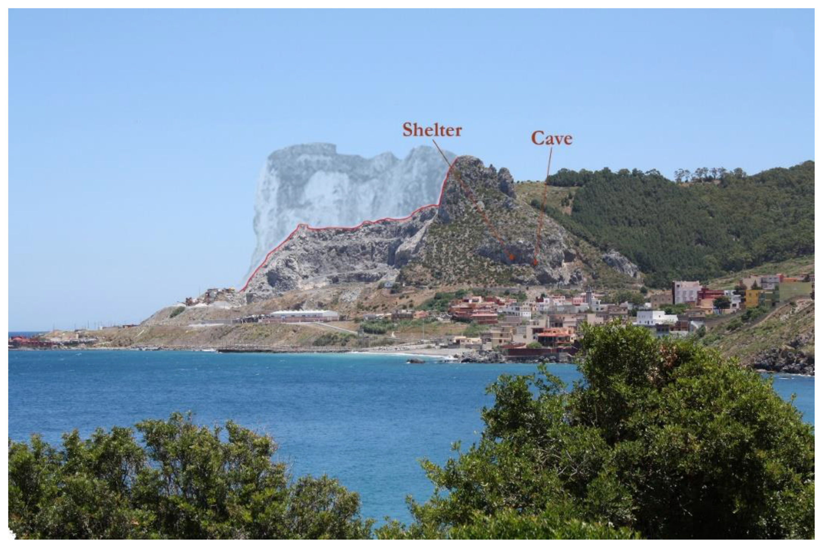
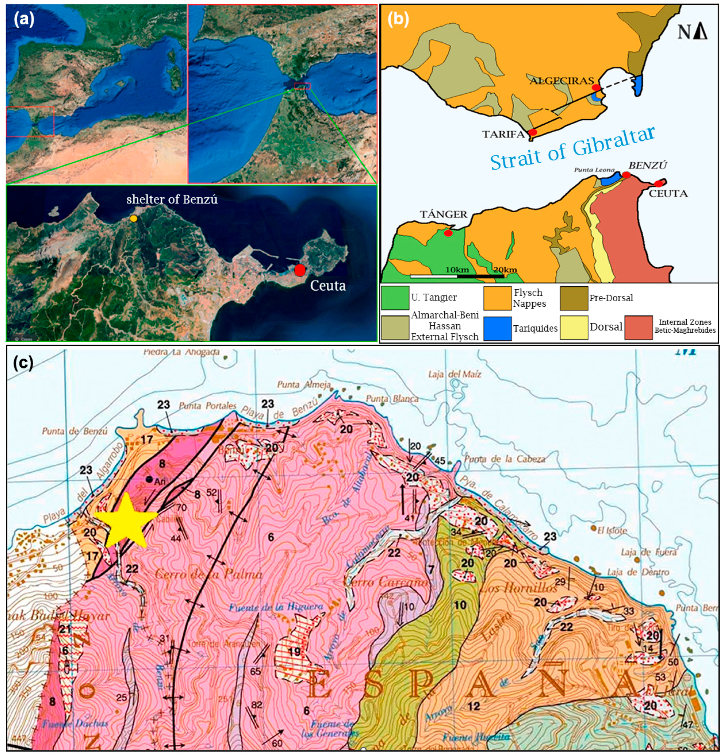
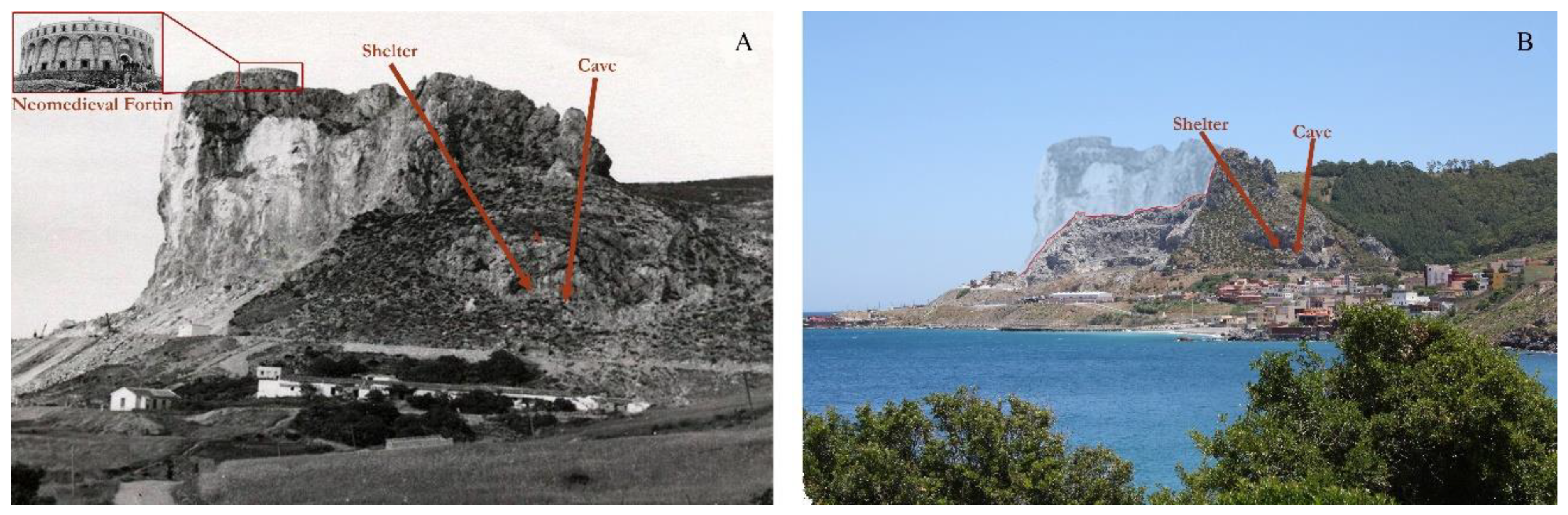
2. Location, Natural Environment, and Geology

The Benzú rock shelter and caveare located in the western sector of the territory of the autonomous city of Ceuta (Spain), on the Strait of Gibraltar’s African shore, at an altitude of 63 m.a.s.l. and about 200 m from the current coastline (Figure 1a).
The Benzú rock shelter [21,22] is characterised by a precipitous topography (Figure 2), with almost vertical slopes, open in Triassic dolomitic rocks. Currently, most of the ceiling has collapsed, and the fallen blocks can be seen scattered on the slope that leads to the site. Before the new digital model was generated, its known dimensions were 15 × 4.50 m.
The Benzú cave [26] is located just a couple of metres to the southwest of the Benzú rock shelter, and presents a narrow and steep entrance which is 5.4 m long and 4.6 m wide (total pre-model area: 14 m2) [32].
From a geological point of view, the site de Benzú and the region around Ceuta is in the confluence between the Rif and Baetic mountain ranges, in the Alborán domain (Figure 1b) [33,34]. These materials correspond to the Mesozoic-Cenozoic paleomargins of the Iberian and African Plates, respectively. Structurally, the Flyshs units and the pre-dorsal units are situated between the Alborán domain and the Sub-Iberian and Maghrebi domains [34,35]. In the south of the external Rif Zone, non- or post-orogenic foreland tertiary basins are found: their geology is equivalent to that of the Guadalquivir Valley in the external Baetic zone [34] (Figure 1b). Regionally, different complexes can be found in the Ceuta region, such as the Alpujárride/Sébtide complex, the Maláguide/Gomaride complex, and the pre-dorsal Rif units, comprising limestone units mainly from the Triassic and Lower Jurassic. The karst-formed materials in the Yebel Musa formation are very similar to those in the Rock of Gibraltar, and this reflects on the Triassic dolomitic rocks of the Benzú rock shelter and cave (Figure 1c), on the Lower Jurassic limestones of the Lower Jurassic Ridge, and on the Lower Jurassic dolomites of Yebel Musa (Figure 1b) [36]. Other rocky outcrops found near the cave and shelter are blue-grey phyllites, quartzites, Permo-Triassic schists, limestones, and red marls and pelites, with alternating Flysch sandstones [37,38,39]. Finally, anthropic alterations undergone by the cave since the earliest human occupation must have been minimal compared to exogenous processes, including cementation in limestone breccias, which has contributed to the preservation of archaeological artefacts. It is also possible that the front ceiling of the shelter collapsed during the Quaternary as a result of external geological processes [25], and due to the influence of coastal erosion processes in recent geological periods.

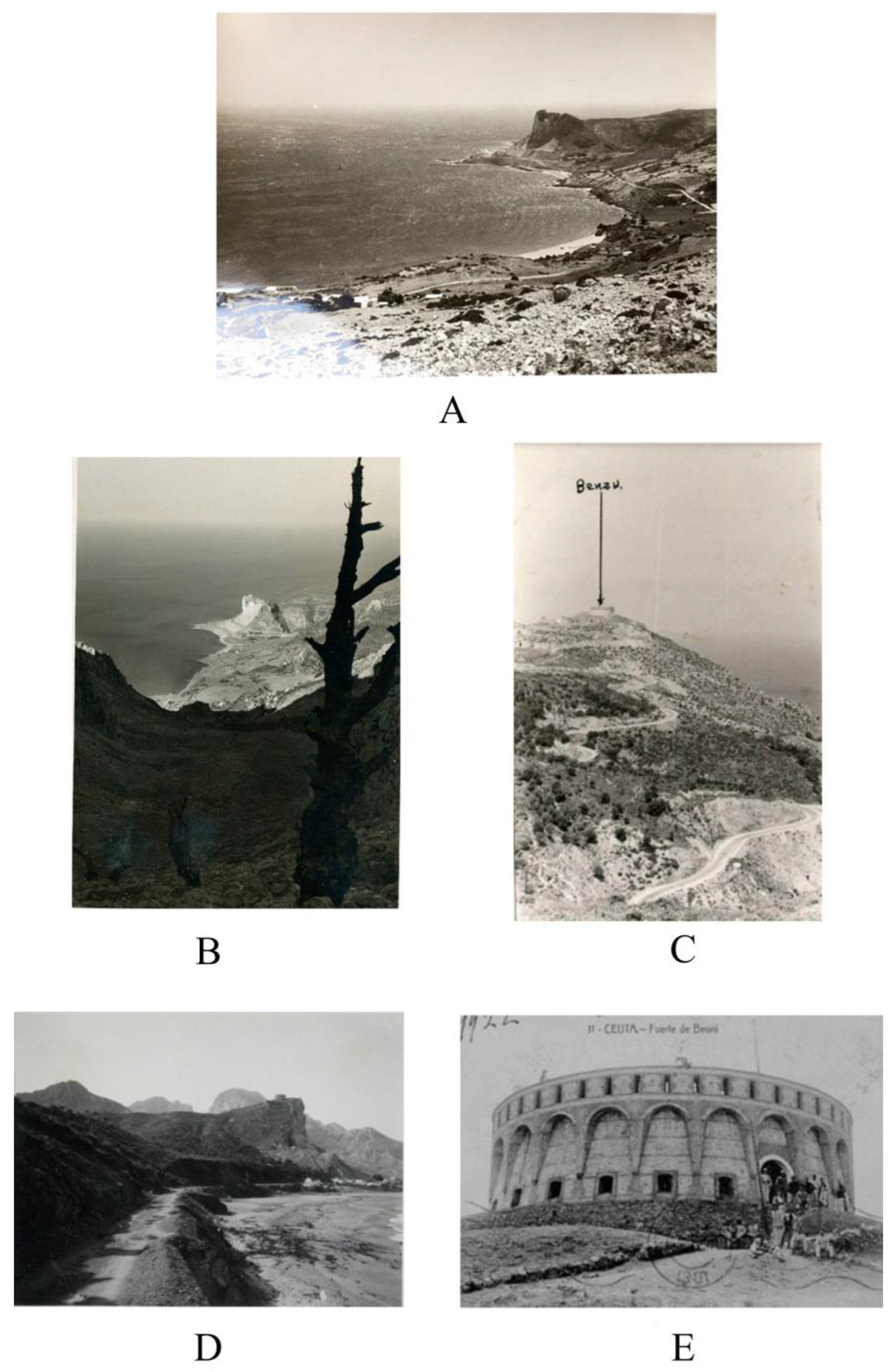
3. Conservation Issues: Historical Evolution of the Archaeology of the Mogote de Benzú

The first historiographical reference to the prehistoric sites in Benzú corresponds to the geoarchaeological study carried out by Miquel Tarradel and Juan Garriga in the 1950s. It is important to note that, in contrast to most studies being undertaken in Spain and Morocco at the time, these researchers were greatly concerned with developing an interdisciplinary scientific method: this put their work well ahead of its time [40,41]. In their geoarchaeological analysis of the fluvial and marine terraces of the Martil River and the coastline between Ceuta and Tétouan, they emphasised the need to organise Palaeolithic industries according to their geological context, considering fluctuations in the sea level and the correlation between glaciations and rainfall regimes. A map of the Benzú Bay, dated to 1951, which locates Palaeolithic finds on quaternary terraces and in the vicinity of the site, as well as the quarry, is especially interesting (Figure 2A) [40,42].
Our interest in the region led our team to contact Nuria Terradell Font, Miquel Terradell’s daughter, to request access to the Archivo Tarradell, deposited in Barcelona. The archive holds the records of the work carried out in the Spanish Protectorate of Morocco [43], and also for the significant archaeological sequences [44,45] found in Gar Cahal and Kaf That el Ghar [46,47]. In addition to the detailed records corresponding to these two caves, which are near Tetouan (Morocco) [48], the archive contains relevant information about other archaeological sites. Concerning the conservation issues that beset Benzú, in addition to the map of the Benzú Bay which locates the quarry right next to Punta Benzú [40], there is a large number of highly interesting photographs of the area of La Ballenera, the sector around Benzú, and the existing Ceuta–Morocco border, all dated to the early 20th century (Figure A1, Appendix A). The photographs illustrate that the area of Beliunes still showed little evidence of anthropic activity as late as the 1950s. On the other hand, records examined in the Archivo Central de Ceuta allowed us to trace the evolution of the fort de Benzú, beginning in the 1900s, before the quarry began affecting the Mogote de Benzú. Figure 2B and Figure A2 (Appendix A) reflect the gradual damage inflicted by the quarry and those areas that are still, for the most part, unaffected by it, including the Benzú rock shelter and cave.
With the beginning of archaeological work on the Benzú rock shelter and cavein 2002, a topographic survey was undertaken [32], and this has been used to monitor the effects of quarrying while excavations were ongoing. This attested the collapse of the front ceiling as a result of the explosions, which have weakened and fissured the dolomitic rock. In this way, before the beginning of each excavation campaign, the surfaces of the shelter were surveyed and cleaned with speleological equipment to prevent further collapses [23]. Several fissures have been found in the cave that are believed to have been caused by detonations in the nearby quarry. In fact, the report presented to the Spanish Ministry of Culture to declare the cave and shelter as a BIC in 2008 already suggests that: “The cave presents a longitudinal fissure running across much of the ceiling. Recently, the fissure has broken the stalagmitic mantle in some areas. The cave is in a fossil state, that is, there is no sufficient water input for the karstic processes that form stalactites, stalagmites, and stalagmitic mantle. If the fissure had opened long ago, when karstic processes were still active, it would have been filled by the stalagmitic mantle”. In addition to this, it should be noted that the site is in a vulnerable location, on the strategically and militarily important Spanish–Moroccan border, and it often witnesses incidents related to people smuggling. For these reasons, new graphic and digital records with which to monitor the topography of the site are essential for conservation and research purposes, helping to track future deterioration with up-to-date technologies.
In this context, 3D laser scanning and multitemporal modelling technologies not only enable millimetre-accurate capture of the site’s current conditions but also allow the identification of fractures, potential differential movements, and risk areas that could compromise its preservation and the safety of future visitors. However, this natural fragility is exacerbated by anthropogenic factors, particularly the proximity of an active quarry, whose operations may generate vibrations capable of accelerating microfracturing in the surrounding area and disturbing the geotechnical stability of the system. The exploitation of the surrounding terrain, in addition to posing a structural threat, also undermines the landscape value and the visitor experience at the site, negatively impacting outreach and heritage enhancement initiatives. To assess the structural condition of the Benzú cave and its implications for site conservation, three representative sections of the complex were selected (the entrance, the interior of the cave, and the rock shelter), where a notable concentration of fractures was observed. The linear fracture density was analysed using the same 3D scanning data. On each surface, 20 virtual lines of one metre in length were drawn, and the number of fractures fully intersecting each line was counted. Linear density values (Df) were calculated using the formula Df = N/L, and an average value was obtained for each section.

4. Digital Theoretical Framework

The evolution of “new technologies” in relation to the digital and virtual recording of archaeological heritage has led to the development of fieldwork tools that improve recording and have the potential to generate a large amount of graphic information. As a result, these techniques have become part of the standard toolkit of research and conservation projects, for instance with the reproduction and reconstruction of archaeological artefacts and the visualisation of archaeological features. There are multiple examples of the use of 3D virtualisation and reconstruction for conservation and protection [49,50,51,52,53,54], including with virtual reality (VR) systems.
When these methodologies are applied, it is important to understand the ultimate purpose of the digital twin. One of the most common goals is conservation and recording, and 3D technologies can be of great help in this regard. This is closely related to dissemination, with the development of didactic tools for different audiences. The possibilities are endless, such as virtual recreations, infographics, virtual tours, augmented reality, etc. Finally, these techniques can also be used for analysis and interpretation, and in this the selection of the right technique and equipment is crucial: digital twins must be accurate and precise. In addition, different filters can enhance certain characteristics of the materials to support research or conservation practices.
Regarding this, 3D models have been use to undertake the morphometric analysis of architectural monuments/features [52,53,54,55,56,57]; stratigraphic analysis [58]; conservation assessment [59]; and structural degradation and non-invasive recording of rock art [49,60]. The quality and level of detail of the models must meet the needs determined by the goal, and thus the technique chosen, leading to various methodological strategies [61,62,63,64]. Another major aspect in digitalisation is the need to align with scientific rigour at all times, as set out in the Seville Charter (2012), including the design of a clear work plan that considers different variables, such as environment, orientation, vegetation, etc.

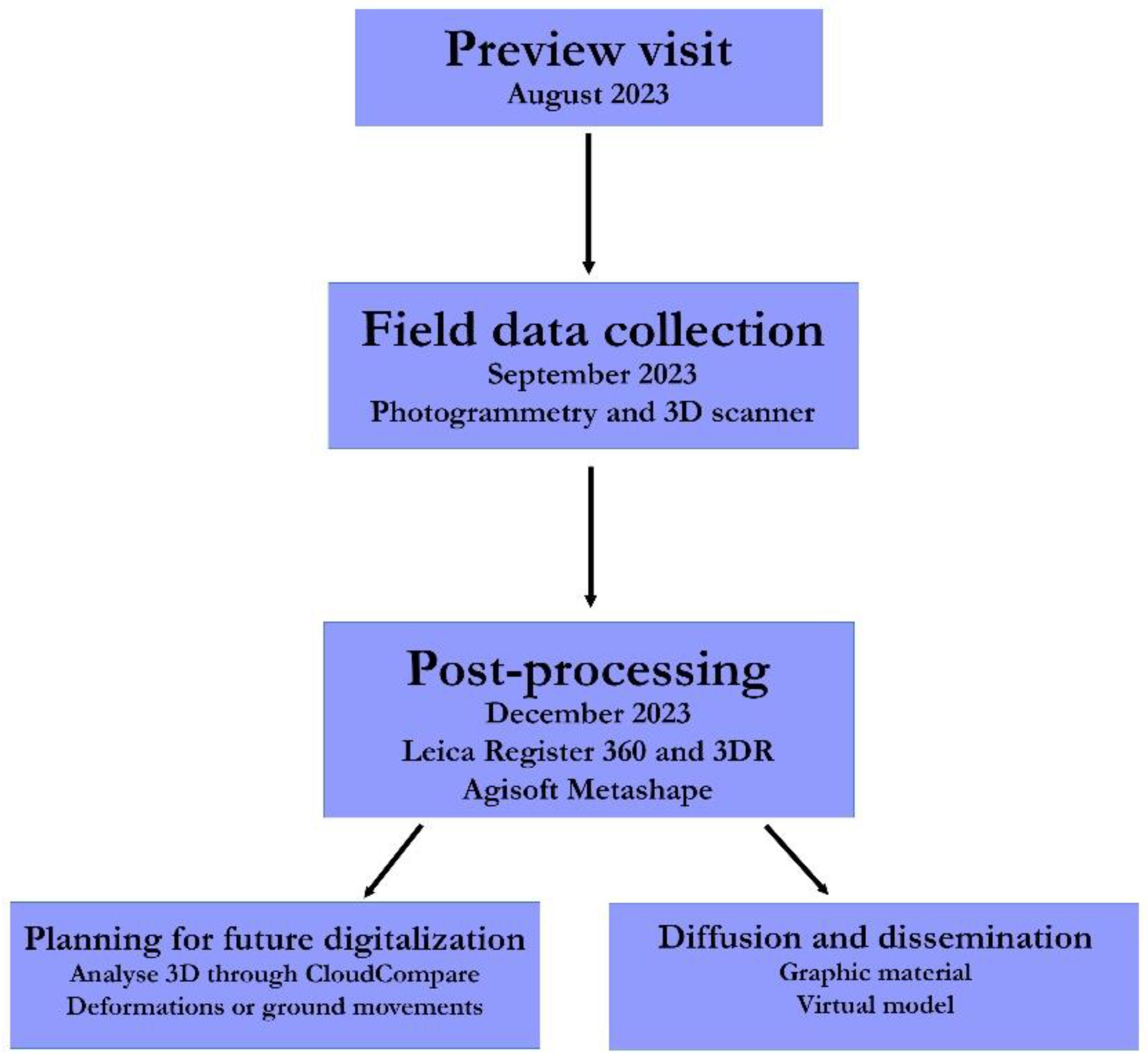
5. Material and Methods

The main goal of our project was to assist in the conservation of the site. A comprehensive and accurate digital model of the Benzú rock shelter and cave was generated, which involved adapting the methodology to the characteristics of both spaces.
To maintain a complete record of all the steps taken during data collection, documentation sheets were used to gather all relevant information, including the site, date, operator, number of photographs, camera settings, etc. To carry out the three-dimensional survey using photogrammetry and 3D scanning, state-of-the-art equipment was employed, providing optimal and precise results in terms of the morphometric fidelity of the cavity, its dimensions, topography, etc., including the following:
-
A Nikon D3100 with 14 MP, equipped with an 18–55 mm lens (Manufactured by Nikon Corporation, Tokyo, Japan).
-
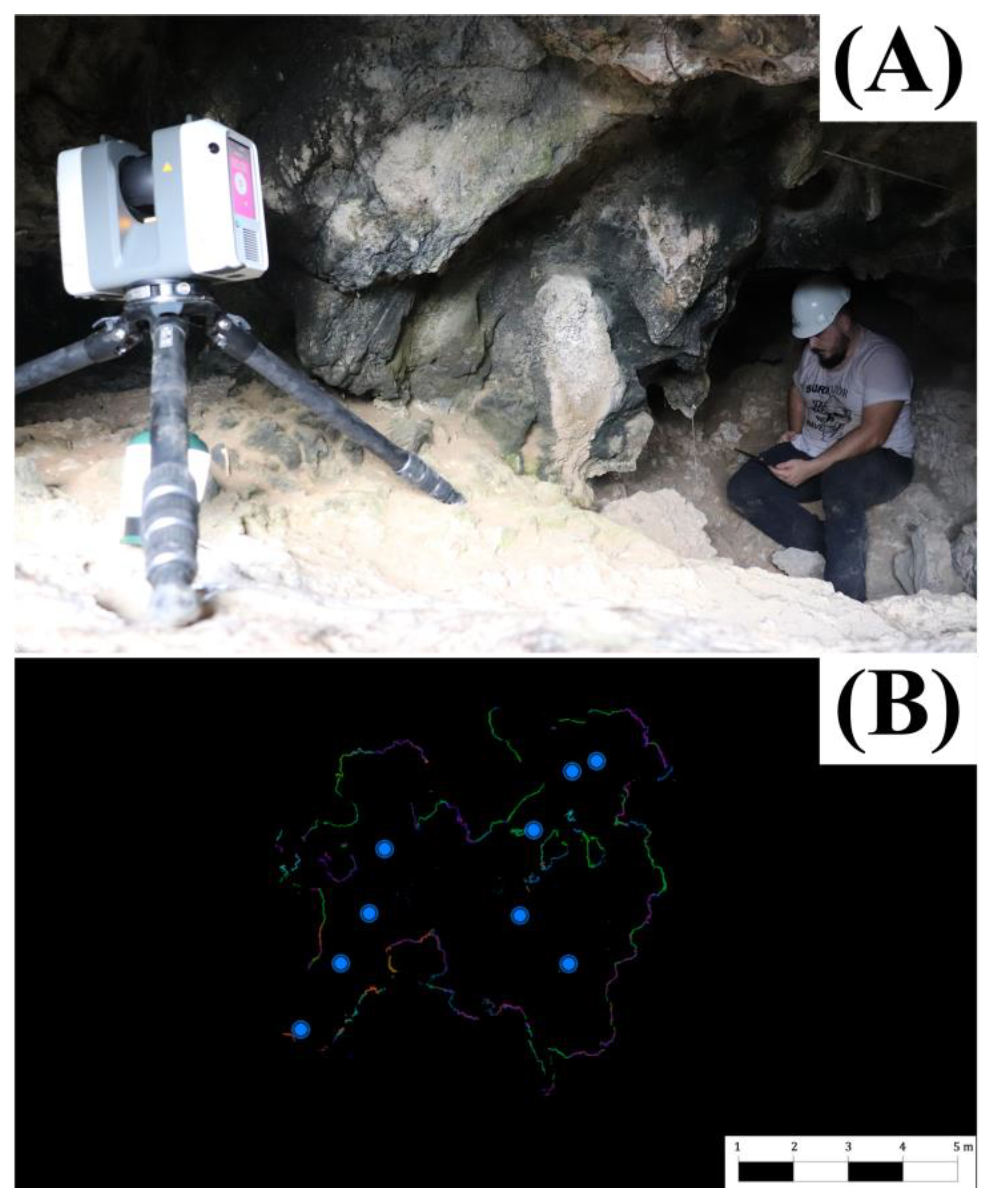
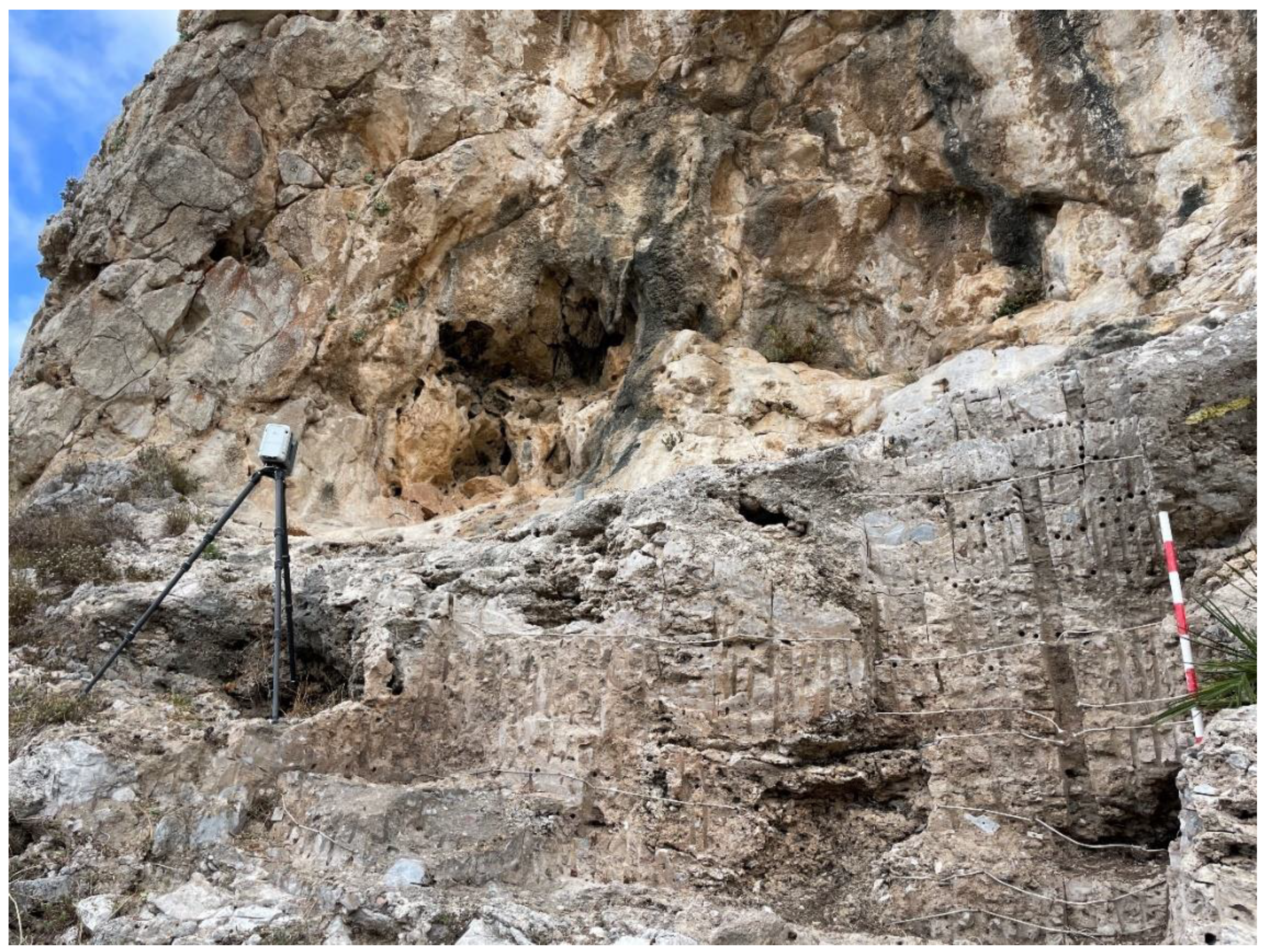
A high-speed Leica RTC360 laser scanner (Manufactured by Leica Geosystem, Heerbrugg, Switzerland) with an integrated HDR spherical imaging system and visual inertial system (VIS) for real-time registration. It features automatic object removal with its double-scan function. The scanner has a 360° horizontal and 300° vertical field-of-view, with a range of up to 130 metres and the ability to record up to 2,000,000 points per second. Remote control of the functions is available via a mobile device using Leica Cyclone Field 360 software (v. 2025.0.0), which allows real-time 2D and 3D data visualisation and automatic scan alignment.
-
An iPad Pro (Manufactured by Apple, Cupertino, CA, USA).
-
A Leica GS18T GNSS RTK (Manufactured by Leica Geosystem, Switzerland), which combines GNSS and IMU (tilt compensation), connected to multiple constellations to receive real-time corrections.
-
Additionally, different software applications were used for the processing phase, each tailored to its respective method before combining the data. For photogrammetric processing, Agisoft Metashape 1.8 was used, while Leica Register 360 and Leica 3DR (v. 2021.0) were employed for 3D scanning. These software applications were installed on a high-performance computing system comprising an Intel i7 8700 4.6 GHz 8-core processor, 64 GB of RAM, and an 8 GB AMD Radeon GPU.
The workflow sequence was as follows (Figure 3):

5.1. Fieldwork

Fieldwork involved the use of 3D scanning and photogrammetry. The positions of the 3D scanner considered the shape and structures of the sites, cavities, and the overlap between stations. It must be noted that the strategic position of the sites precluded the use of drones for orthophotography and photogrammetry, owing to national defence concerns.

5.1.1. The Recording of Benzú Rock Shelter

The Benzú rock shelter is only a few metres from the entrance to the cave: both overlook the west of Mogote de Benzú. This led us to limit fieldwork to the morning hours. The vegetation that covered the sheltered was removed. The morphometry is not particularly complex, except for a few somewhat concealed isolated areas.
The digital model of the Benzú rock shelter was based on high-resolution manual photographs and topographic references taken with a GNSS. The combination of these data resulted in a high-resolution geometric model with photo-realistic textures. The position of the site, close to the Moroccan border, precluded the use of drones with which to take aerial photographs, which would have improved the model of the higher sections of the rock shelter.
The strategy adopted for photogrammetric recording was influenced by the morphology. This included a first sweep from bottom to top, with a minimum photograph overlap of 70–80% to improve the resolution in the stratigraphic sequence excavated in 2014. After that, this was followed a second sweep of the whole wall from different angles, to increase the scope, and nearly vertical zenithal photographs to capture surface features (Figure 4). Thanks to the sharp morphology of the rock shelter and the installation of metallic elements on the surface, there was no need to install GCPs as photographic targets. The reflex camera used as the photogrammetric recorder was a Nikon D3100 set to ISO-400, diaphragm f/10, exposure time 1/200 s, and 18 mm focal distance. Laser scanning followed virtually the same sequence as the photogrammetry, with a first sweep of the bottom sections and then the rest, with stations set on the shelter’s floor. Scanning settings were the same as in the cave except for the double scanning, which was not necessary owing to the more open structure of the rock shelter and which allowed stations to be situated at a greater distance and provided greater post-processing leeway. The GNSS RTK was positioned inside metal scaffolding tubes installed during the excavation seasons [23]. This created fixed points (X, Y, and Z coordinates taken by GPS), making the installation of photographic targets unnecessary.

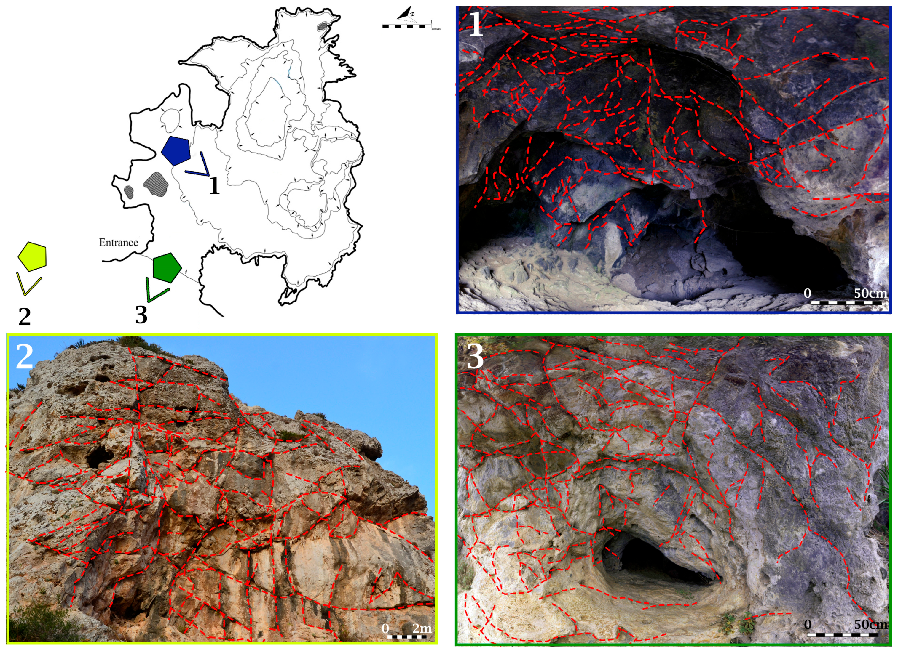
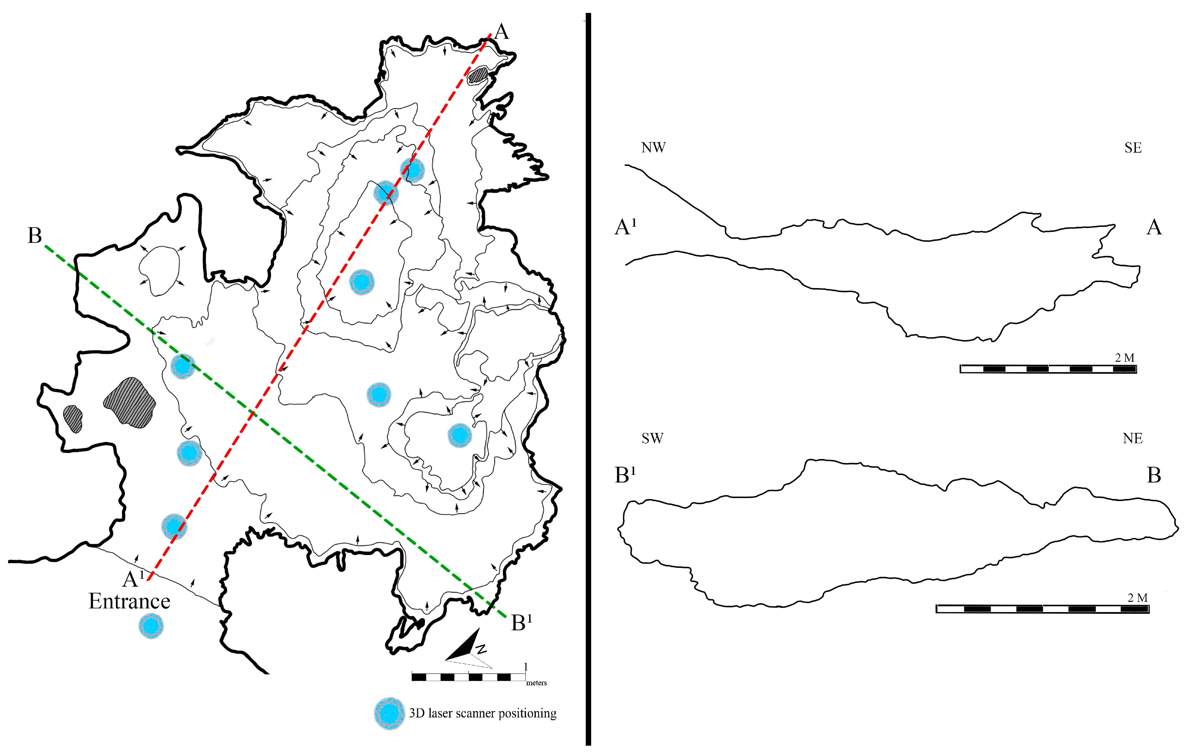
5.1.2. The Recording of Benzú Cave

Several factors limited data collection in Benzú cave. First, the total lack of natural light could not be solved by installing artificial light sources, owing to the small distance between floor and ceiling. Photogrammetry was ruled out for the interior of the cave, as well as the use of GNSS which proved impossible to install. Therefore, the cave could only be recorded through 3D scanning (Figure A3A, Appendix A). Only safe stations were chosen, so some small areas could not be recorded (Figure A3B, Appendix A). Fortunately, these small ‘gaps’ could be filled with information from earlier topographical maps [26].
Difficult access conditions also prevented the technician from leaving the cave during scanning to avoid the presence of foreign elements. For this reason, the top point cloud resolution was selected (1.9 mm–10 m accuracy and a level of noise of 0.4 mm at the same distance), 360 degrees scanning, VIS technology for real-time recording, and double scanning, which allows the suppression of all elements that do not match in both takes. This doubled scanning time but ensured the absence of interferences.
Despite the virtual absence of natural light inside the cave, scanning was undertaken when the sun was not visible through the entrance to avoid saturations and strong light contrasts in the use of 360° photographs. To procure a minimum amount of light, a small lamp was installed in the bottom part of the scanner. Since the main goal was to generate an up-to-date plan of the Benzú cave, the main aim was to obtain a good outline of its boundaries and so the almost total lack of light was not a problem.

5.2. Laboratory Work

Following field data collection, the data were processed in the laboratory. This required high-powered computers in terms of storage space, CPU, GPU, and RAM.

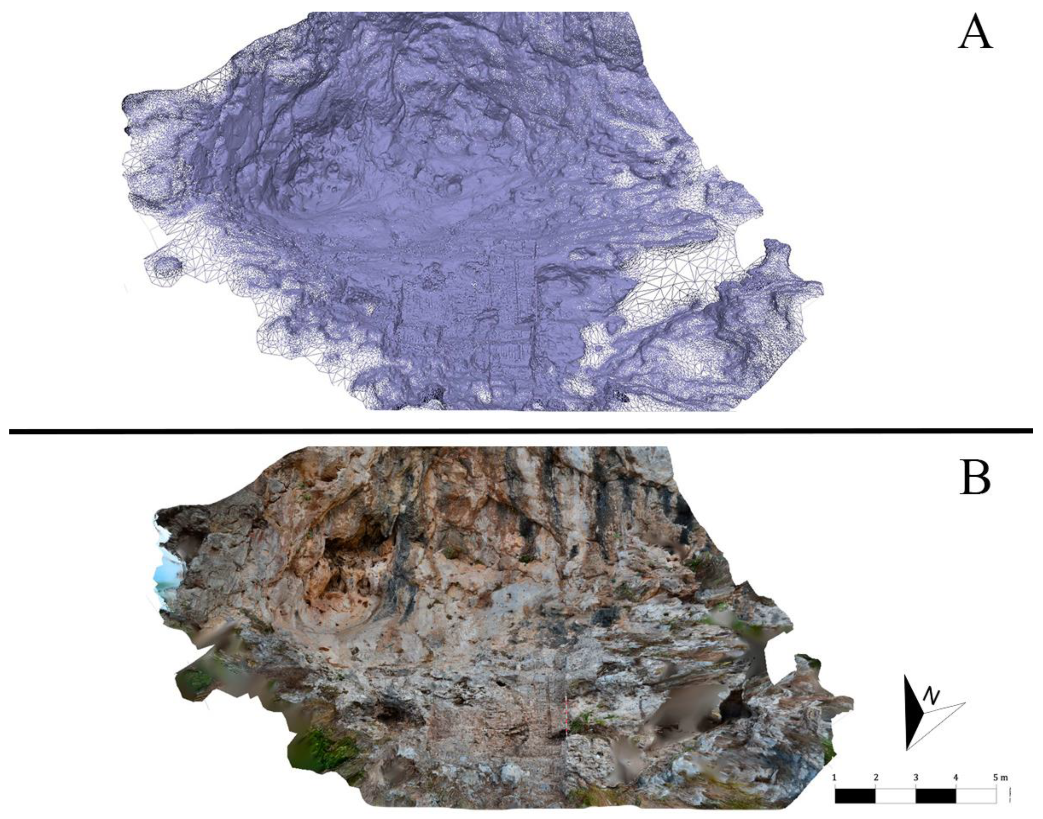
5.2.1. Postprocessing of Data from Benzú Rock Shelter

First, 3D laser scanning data were processed with Leica Cyclone Register 360, which revises the manual alignment undertaken with the app in Ipad Pro, and each link was checked individually to improve the percentage of overlap as much as possible. This led to a bulk point cloud error of 0.004 m, an 86% overlap, and a strength of 67%. After this, the model was exported to .pts and .e57 formats. The one used was the latter, because it not only deals with point clouds but also with the 360 HDR images to combine the laser scanning and photogrammetric data. Agisoft Metashape Professional 1.8.5 was used to process the photographs taken in the field. All photographs were imported alongside a laser scanning model and the .e57 file based on the laser scanning data. This allows the software to recognise the model and extract the 360 HDR images that will be aligned with the photographs taken manually with a Nikon reflex camera.
The workflow to generate the final model was as follows:
  • Alignment. The software detects key points in the photographs (stereo couples) to calculate the position of the camera. This first step generates a disperse cloud that presents a preliminary image of the 3D model.
  • Dense point cloud. This point cloud is denser and allows for corrections, including the filtering of points according to confidence. This allows for the assessment of the quality of the 3D model generated, and the greater the confidence level, the more accurately the model represents reality.
  • Generation of the mesh, which is a 3D geometric model. This model is composed of vertexes (points), edges (unions between points), and polygons (the face formed by linking two or more points in a closed circuit). The model allows for full-colour previsualisation.
  • Texturing. This process lays an image over the mesh, adding the colours calculated based on the key points to give the final 3D model a photorealistic finish.

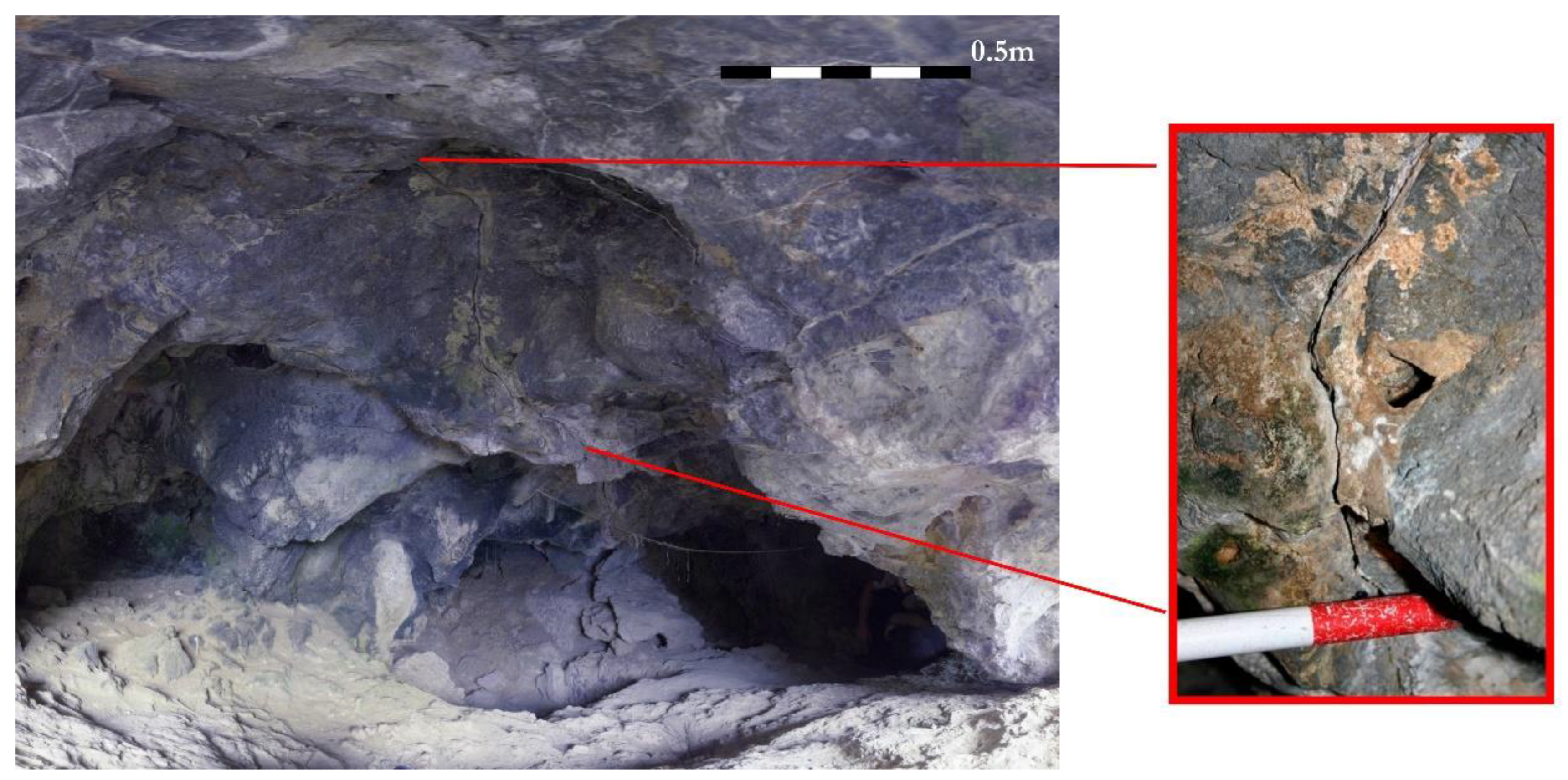
5.2.2. Postprocessing of Data from Benzú Cave

Initially, the processing of the data for the cave followed the same protocol concerning laser scanning, but further steps were taken with Leica 3DR, after importing the e.57 file, to remove foreign objects. A point cloud and mesh were generated for each station of the scanner, leading to a solid model, which, for reasons of space and angles, presents some gaps. However, their quality and geometry are sufficient to generate a new plan of the cave, which was the project’s main goal. The plan was developed from the 3D model, which was horizontally sectioned at the entrance of the cave, respecting the natural slope.

6. Results. Virtualisation as a Digital Conservation Model

6.1. Benzú Rock Shelter

The virtualisation of the rock shelter has resulted in a morphometrically exact digital twin, suitable for monitoring its state of preservation in the future (Figure 5). The same protocol will be undertaken annually to detect changes and possible new damages. The disperse 3D point cloud comprises 329,829 points, the dense cloud 608,323,157 points, and the mesh 54,342,954 faces.
The 3D model includes the excavation area, a section which is 3.03 m wide, 4.84 m high, and up to 1.17 m deep. In total, the model represents 11 m from the base of the archaeological section to the highest visible point. In order to ensure sufficient detail, a specific 3D model for the excavation area was undertaken. The disperse cloud comprises 460,516 points, the dense cloud 24,841,000 points, and the mesh 18,458,547 faces, which guarantees a sufficient level of quality.
Topographic data were collected with a differential GPS GNSS Leica GS18. The UTM coordinates of the rock shelter are ETRS89 285,288.100, 3,976,804.688, 63.609. The coordinates of the archaeological section are 285,287.372, 3,976,804.625, 62.905.

6.2. Benzú Cave

The methodology used was used to update the plan of the cave, better outlining its dimensions and internal morphology. Its maximum depth is 6.215 m from the entrance to the far end. The maximum width is 5.76 m. The entrance has a height of 0.79 m, before it narrows to 0.44 m. Inside, the height increases to 1.06 m and 1.26 m. The maximum current height is the area where the excavations ran deeper, which is to 1.83 m. The difference in elevation between the highest and the lowest point is 2.59 m.
The 3D model generated with the Leica RTC360 scanner resulted in a point cloud with over 351 million points after cleaning. The mesh was composed of approximately 816 thousand faces. According to the data collected, the total surface of the cave is 55.24 m2. Owing to the great accuracy of laser scanning, as an example, the area of the cave affected by one the greatest fissures could be accurately documented in previous works (Figure 6). The data suggest that this fissure has an aperture between 10 and 25 mm and is larger than 150 cm. Based on the data generated through three-dimensional documentation, it has been possible to measure the fractures affecting both the exterior and entrance area of the cave, as well as its interior. This has allowed for an update of the documentation regarding the current conservation status of the cave and the registration of previously undocumented fractures. The results reveal a very dense fracture network with intersecting traces forming angles between approximately 20° and over 120°, indicating the superposition of at least three structural sets: (1) a subvertical N–S set associated with dextral shear and the N–S folding of the Benzú anticline; (2) an ENE–WSW set, with moderate dip, linked to extensional phases and regional normal faults; and (3) a NE–SW set, with intermediate orientation, probably related to the main dextral fault and its reactivations. The average linear fracture density (Df) is 8.9 fractures/m at the entrance, 9.8 fractures/m in the cave interior, and 7.0 fractures/m in the outer rock shelter (Figure 7). These angular intersection patterns define rock blocks with high potential for detachment in response to events such as natural earthquakes, vibrations caused by quarry activity, and/or water infiltration.
According to the GNSS, the UTM coordinates of the entrance of the cave are ETRS89 285,288.156, 3,976,792.358, 63.444. The model meets the project’s goal to generate a new plan and sections of the interior of the cave (Figure 8) to better understand its morphology and topography.

7. Discussion

7.1. Technical Aspects of This Methodology

The archaeological complex of the Benzú rock shelter and cave constitutes a paradigmatic case in which basic archaeological research, preventive conservation, and heritage socialisation converge under a theoretical–practical approach that combines scientific rigour with the application of advanced digital methodologies. In this context, the research team from the University of Cádiz has played a key role through systematic excavations and surveys, which have produced significant results for the understanding of Middle Palaeolithic hunter-gatherer societies—characterised by Mode 3 technologies—as well as for the study of Neolithic and Bronze Age communities. This continued research has established a solid empirical basis for interpreting the site and has justified the need to adopt high-precision documentation procedures. The combined implementation of 3D laser scanning, digital photogrammetry, and GNSS georeferencing systems has enabled the generation of comprehensive digital models of both the rock shelter and the cave, preserving their topographic and geomorphological configuration with sub-5 mm accuracy. This level of resolution falls within the range considered optimal for heritage documentation, in accordance with the guidelines established in the Seville Principles (2011). The capacity of these technologies to operate in environments with difficult access, limited lighting, or complex morphologies [65,66]—as is the case at Benzú, where conventional techniques proved unfeasible—makes them particularly suitable tools for non-invasive documentation in sensitive spaces. Nevertheless, it must be emphasised that the mere production of high-quality digital models does not represent a significant scientific advancement by itself unless accompanied by proper archaeological contextualization and integration into conservation and management strategies [31]. In this regard, the models generated have been validated not only for their geometric accuracy but also for their practical utility in preventive conservation tasks. They have also been employed for fracture measurement, providing a crucial support tool for decision-making in heritage protection. Integration with GIS platforms, facilitated by the use of differential GNSS, has further enabled precise georeferencing of the 3D models, expanding their potential use in spatial analysis, land-use planning, and multitemporal monitoring.
The updated topographic survey of the site has made it possible to achieve the proposed objectives. Firstly, it has provided a more accurate and detailed database obtained through 3D scanning, enabling virtual reconstructions of the site and its integration into interpretation centres. Secondly, it has facilitated the monitoring of the site’s conservation status through multitemporal comparisons. Finally, it has opened the possibility of producing both physical (scale models) and virtual (interactive models or augmented reality experiences) three-dimensional reconstructions aimed at improving the accessibility, dissemination, and enhancement of the site—particularly within the urban and cultural context of the autonomous city of Ceuta. Furthermore, the outreach activities promoted by the research group—including open days, lectures, popular science publications, and guided tours—have made a decisive contribution to reinforcing the public dimension of heritage.
Despite the inherent advantages of these technologies, their application requires critical reflection. Their effectiveness is directly conditioned by the availability of economic and technical resources, the specialised training of personnel, and appropriate methodological planning. Although powerful, these tools are not neutral as they involve key decisions regarding which elements are documented, what levels of precision are deemed acceptable, and how the generated data are interpreted [67]. Consequently, their use must be guided by rigorous scientific criteria and ethical principles that consider the sustainability, accessibility, and integrity of heritage.
From an economic and operational perspective, one of the main challenges is the high initial cost associated with acquiring the necessary equipment (such as laser scanners, total stations, drones, and professional software licences), as well as with technical training and personnel mobility. Although these costs can be amortised through repeated use of the equipment and reuse of the data generated, they represent a significant barrier for many projects with limited funding, particularly in institutional contexts with fewer resources. On the other hand, digital methods may require a more time-intensive initial phase for data capture and processing. However, they offer a clear operational advantage in the subsequent stages of analysis, editing, and the generation of derivative products. The ability to revisit already recorded data without the need to return to the site constitutes a considerable saving in both logistical and economic terms. It is also important to consider the need for high-performance hardware and specialised software, which can limit access to these methodologies in environments with less developed digital infrastructure. Additionally, the longevity and management of digital data raise critical questions as technological obsolescence, proprietary software formats, reliance on commercial licences, and the need for secure storage all demand clear digital preservation policies that ensure the integrity, interoperability, and accessibility of information in the medium and long term.
The selection of the technological tools used in this project, including 3D laser scanning, photogrammetry, GNSS positioning, and specialised post-processing software, was based on a rigorous assessment of the specific needs of the Benzú cave and rock shelter site. The integration of these technologies responds to the particular challenges of the environment, such as visibility and accessibility conditions, the fragility of the structures, and the need to obtain high-precision digital models through non-invasive methods.
The Leica RTC360 3D laser scanner was selected not only for its technical specifications but especially for its ability to capture topographic and geomorphological details with millimetric precision [67,68,69,70]. This level of accuracy is essential in environments such as the Benzú cave, where conventional recording techniques are limited by low natural light and the morphological complexity of the space. Nevertheless, it is important to note that despite its high performance, this technology presents certain limitations, mainly related to the high cost of the equipment and the need for specialised technical training for its proper use and interpretation. Regarding scanning parameters, the Leica RTC360 offers specific configurations that allow data capture to be adapted to different contexts and objectives. Among these, the ability to select the quality level of the point cloud—available in low, medium, and high settings—is particularly notable as it directly affects the density of the acquired points. This density is influenced both by the proximity of objects to the scanner and by the level of detail required. The choice of quality setting must consider the type of object to be documented and the environmental conditions. The high-quality configuration enables the capture of large volumes of points per second in 360° sweeps, with a range exceeding 150 m. However, in contexts where the elements of interest are located at relatively short distances, this option may generate redundant or unnecessary data from peripheral areas. For this reason, the medium and low settings are sometimes preferable as they focus on nearby elements and reduce density in more distant areas. In the specific case of the Benzú cave, the high-quality setting was selected in order to generate a detailed topography of the interior of the cavity. This decision allowed the scanner to concentrate its acquisition capacity on internal surfaces, thereby maximising the precision of the three-dimensional model. Similarly, in the Benzú rock shelter, located in an outdoor environment with vegetation and a field-of-view of approximately 180°, the high-quality setting was also used to ensure adequate resolution across the entire documented surface.
This methodological choice allows for comparisons with other devices of similar performance. For example, the Leica RTC360 can record up to 2.5 million points per second in a complete 360° sweep, with a maximum scanning time of five minutes when all parameters are enabled. In contrast, other systems such as the Faro Focus S150 offer comparable point densities and the option to limit the scan to specific angles (such as 45° or 90°) but have the disadvantage of significantly longer scan times per station, which can reach up to 40 min. Another relevant feature of the equipment used is the VIS (visual inertial system) technology, which combines visual and inertial data to determine the scanner’s position and orientation in real time. This represents a significant advancement in point cloud registration and alignment processes, without increasing working time. The scanner also includes a dual-scan system capable of detecting object movement or displacement during the process, automatically removing such elements from the generated point cloud; however, this feature doubles the scanning time. In the case of the Benzú cave, this option was deactivated as no moving elements were present inside the cavity and the operator remained outside the scanner’s field-of-view at all times, controlling the device remotely via the Leica Register 360 app installed on a tablet. Finally, the scanner allowed for the acquisition of 360° spherical images, which adds approximately one minute to the total scanning time. This feature was enabled in both the cave and the rock shelter, as—despite the limited natural light in the cavity and the fact that the main objective was topographic documentation—the inclusion of spherical images made it possible to visually identify fractures and other relevant morphological features, thereby facilitating accurate measurements on the resulting 3D model.
The combined use of laser scanning and photogrammetry, along with GNSS referenced data, made it possible to optimise the documentation of the rock shelter by integrating metric precision with photorealistic texturing. The selection of photographic parameters (ISO, aperture, exposure time, and focal length) was adjusted to maximise image quality in an environment with variable lighting conditions. This methodological integration has enabled the generation of highly detailed three-dimensional models, useful for both scientific research and museum or outreach applications. Finally, it is important to note that the use of digital technologies in archaeological documentation and recording represents a profound methodological transformation. It improves precision, accelerates processes, reduces the margin of error, and expands the possibilities for the analysis, conservation, and dissemination of archaeological heritage (Table 1). However, it does not completely replace traditional methods but rather complements them [71], providing new tools for more comprehensive and accessible documentation [31,72,73,74].
In conclusion, the digitalization of the Benzú site has made it possible to overcome limitations inherent to traditional methodologies while also introducing new challenges related to sustainability, accessibility, and digital preservation. To ensure its long-term impact, it is essential to integrate these advances into institutional frameworks that recognise digital documentation as a central operational tool in heritage management policies. This integration requires effective collaboration among researchers, technicians, managers, and public authorities aimed at consolidating a heritage intervention model that is scientifically, ethically, and socially sustainable.

7.2. Research and Conservation Plan

From a conservation standpoint, the designation of the Benzú rock shelter and cave site as a Property of Cultural Interest (Bien de Interés Cultural, BIC) in 2008 introduces a direct responsibility on the part of the autonomous city of Ceuta regarding its protection, monitoring, and active management. However, the site’s geological and geographical context presents multiple risk factors that demand a multidisciplinary approach to any intervention. On the one hand, the presence of karstification processes in the carbonate materials, combined with its location in the tectonic contact zone of the Alboran domain, requires systematic monitoring due to the potential for seismic activity. On the other hand, the proximity of the active quarry and its associated blasting operations represent an immediate anthropogenic threat, with direct impacts on the stability of the rock mass in which the site is located, as evidenced by the fractures and rockfalls documented in previous fieldwork campaigns.
In this context, high-precision digital documentation (based on laser scanning and photogrammetric modelling) emerges as a strategic tool not only for the conservation of the archaeological record but also for the structural monitoring of the site. The generation of updated three-dimensional models provides reliable metric references that facilitate the detection of morphological alterations (such as the displacement or detachment of rock blocks) over time, without the need for continuous physical interventions. This approach optimises conservation resources in fragile or hard-to-access environments. Furthermore, the Benzú cave is located in a tectonically active setting, situated on the Benzú anticline and affected by a NE–SW-oriented dextral fault associated with the thrust front of the Alboran domain [75]. This polyphasic tectonic configuration has produced several fracture sets (N–S, ENE–WSW, and NE–SW) that fragment the rock mass, facilitate the circulation of groundwater, and accelerate the physical and chemical weathering processes of the rock, as well as block detachment. In the context of the moderate to high seismicity that characterises the Ceuta region [76], linked to the convergence between the African and Eurasian plates [75], even low-magnitude seismic events could reactivate these discontinuities and compromise the stability of rock blocks within the cavity. To this natural risk must be added anthropogenic factors, such as the aforementioned blasting at the adjacent quarry which has been associated with the appearance of new fractures and progressive rockfalls in the immediate surroundings [23].
Additionally, the presence of lithologies with differing mechanical competence, combined with slopes exceeding 50% in certain areas [75], increases the likelihood of superficial landslides, particularly in steep zones [50]. This set of factors defines a scenario of high susceptibility to localised rockfalls and partial collapses of the cave ceiling or walls, representing a direct threat to its structural and heritage conservation. In light of this situation, the implementation of a continuous structural monitoring programme is considered essential. Such a programme should integrate geotechnical instrumentation (e.g., crack metres and inclinometers), periodic inspections, and geomechanical modelling of the rock mass behaviour. The information obtained from the 3D model of the cave interior will allow for the precise identification of the most vulnerable zones and guide targeted interventions, such as sealing active fractures, installing passive anchors or protective mesh, and channelling surface water. These actions would contribute to mitigating current risks and ensuring the medium- and long-term conservation of this geological and archaeological site. Furthermore, this line of work supports the feasibility of additional preventive measures, such as installing vibration sensors to record both quarry detonations and potential seismic events, as well as assessing the need for localised structural reinforcements in the most compromised areas of the cavity. Nevertheless, one of the main medium- and long-term challenges lies in the effective integration of these digital products into sustainable heritage management strategies [31,67,68]. Although 3D models, georeferenced databases, and multiscale documentation systems represent significant advances in terms of precision and replicability, their real impact depends on their active incorporation into institutional and regulatory frameworks as operational tools rather than merely documentary resources. To this end, it is essential to promote interdisciplinary collaboration among archaeologists, technical specialists, heritage managers, and policymakers so that digitalization is understood not as an end in itself, but as a tool in service of more efficient, resilient, and inclusive heritage management.

7.3. Heritage Enhancement Proposal

The added value of these technologies also lies in their capacity to generate scientific and educational dissemination products—such as interactive visualisations, virtual tours, or 3D-printable models—that expand access to heritage knowledge without compromising the integrity of archaeological sites. In this way, digital technologies not only document but also democratise heritage. From this perspective, an enhancement strategy is proposed through the implementation of interactive 3D models and augmented reality tools that allow for remote exploration based on the virtualization of the site. This approach not only addresses the physical access limitations imposed by the site’s terrain but also supports an advanced museographic experience accessible to diverse audiences, including individuals with reduced mobility. In parallel, the availability of a digital twin allows for its integration into educational and scientific outreach environments through the generation of high-quality visual resources, infographics, 3D-printed models, and interactive content adapted to different educational levels. Moreover, it is essential to incorporate into the interpretative narrative of the site the risk factors that threaten its integrity, particularly those derived from the extractive activity of the nearby quarry, where the impact on the stability of the rock mass has been confirmed in previous topographic records. This critical dimension should form part of a public awareness strategy that, grounded in scientific evidence, promotes the active protection of the site and informed heritage management. Finally, the three-dimensional model of the cave is available for consultation on the open-access platform Sketchfab (https://sketchfab.com/3d-models/cueva-de-benzu-14acce51777c4390bea4d0bee1e86d32).

8. Conclusions

The archaeological context of the Mogote de Benzú presents a set of geomorphological, environmental, and heritage conservation challenges that significantly influence both research strategies and the long-term management of the site. Located on a coastal limestone promontory with steep slopes and highly porous calcarenite substrates, the Benzú rock shelter and cave are subject to continuous mechanical and chemical weathering processes, exacerbated by exposure to marine aerosol, thermal fluctuations, and wind abrasion. These processes not only hinder safe and stable access to the archaeological structures but also contribute to the gradual deterioration of both the rock matrix and associated deposits. From a stratigraphic and architectural perspective, the configuration of the site—including its near-vertical relief, partial collapses, and sedimentary instability—limits the capacity of traditional archaeological recording methods to capture the spatial complexity and microtopographic variability inherent to these features. Moreover, the historical evolution of interventions at the site, which began in the mid-20th century without systematic protocols for recording and preserving stratigraphic integrity, has resulted in the partial loss or alteration of archaeological contexts. This cumulative impact has generated major challenges for the spatial and chronological reconstruction of the occupational sequence and the architectural configuration of the structures.
In this context, the application of advanced digital methodologies, such as the terrestrial laser scanning (TLS) and close-range photogrammetry, has proven crucial in overcoming the limitations imposed by the site’s natural and historical conditions. These technologies allow for non-invasive, high-resolution recording of surfaces, volumes, and morphological features, enabling the generation of three-dimensional models with millimetric precision that accurately reflect the current state of the archaeological and geological environment.
These digital models facilitate detailed visualisations and analyses of the spatial relationships between architectural elements, lithostratigraphic units, and natural discontinuities, even in areas with restricted physical access. Furthermore, when integrated into geospatial platforms such as Geographic Information Systems (GIS), these datasets enhance spatial analysis capabilities. Using information derived from the 3D model of the cave interior, it has been possible to precisely identify the zones with the highest fracture density and to propose targeted interventions (such as selective instrumentation, crack sealing, and anchor installation) as measures for future site control and conservation. Additionally, the diachronic application of digital recording methods allows for monitoring of progressive taphonomic changes and erosive dynamics, thereby contributing to the development of preventive conservation strategies tailored to the site’s specific geological and climatic parameters. The creation of a complete and accurate digital replica of the site not only supports advanced analytical procedures and interdisciplinary collaboration but also ensures the preservation of critical scientific data for future research, even in the event of physical degradation or catastrophic loss.
By providing a reliable and reproducible model for both documentation and interpretation, the digital workflow adopted at Mogote de Benzú represents a significant methodological advancement in the management of complex archaeological contexts embedded in fragile geological environments. This approach sets new standards for data integrity, spatial analysis, and heritage conservation in prehistoric coastal settings subject to multifactorial degradation.
Finally, the experience developed at Benzú demonstrates that heritage digitalization should not be understood as an end in itself, but rather as a methodologically grounded and interdisciplinary process where archaeology, geospatial engineering, applied computing, and cultural management converge. Its impact will depend on its alignment with sustainable public policies, accessible digital infrastructures, and participatory strategies for heritage conservation and outreach—thereby consolidating a replicable and responsible model for archaeological heritage intervention.

Author Contributions

Conceptualization, A.M.-M., E.V.-V., S.D.-B., D.F.-S. and J.R.-M.; methodology, A.M.-M., E.V.-V., J.J.C.-D., S.D.-B., S.B.-M., D.F.-S. and J.R.-M.; software, A.M.-M.; validation, A.M.-M., E.V.-V., S.D.-B., D.F.-S., E.M.-P. and J.R.-M.; formal analysis, A.M.-M., E.V.-V., J.J.C.-D., J.L.R.-A., S.D.-B., S.B.-M., D.F.-S., E.M.-P. and J.R.-M.; investigation, A.M.-M., E.V.-V., J.J.C.-D., J.L.R.-A., S.D.-B., S.B.-M., D.F.-S., E.M.-P. and J.R.-M.; resources, E.V.-V., S.D.-B. and J.R.-M.; data curation, A.M.-M. and D.F.-S.; writing—original draft preparation, A.M.-M., J.L.R.-A. and J.R.-M.; writing—review and editing, E.V.-V., J.J.C.-D., J.L.R.-A., E.M.-P. and D.F.-S.; visualisation, A.M.-M. and D.F.-S.; supervision, E.V.-V., S.D.-B. and J.R.-M.; project administration, E.V.-V., S.D.-B. and J.R.-M.; funding acquisition, S.D.-B. and J.R.-M. All authors have read and agreed to the published version of the manuscript.

Funding

This research was conducted thanks to the financial and administrative support of Ciudad Autónoma de Ceuta, Consejería de Educación y Cultura, Sección de Patrimonio Cultural, within the framework of a partnership agreement between this institution and Universidad de Cádiz (N°. Ref.: MTTR. N°. Exp.: 59.619/2022). Diego Fernández-Sánchez is beneficiary of a formation contract Juan de la Cierva with reference JDC2022-050009-I, funded by MCIN/AEI/10.13039/501100011033 and the European Union (NextGenerationEU”/PRTR”).

Institutional Review Board Statement

Not applicable.

Informed Consent Statement

Not applicable.

Data Availability Statement

The original contributions presented in this study are included in the article. Further inquiries can be directed to the corresponding author(s).

Acknowledgments

To Darío Bernal Casasola (Archaeology, University of Cádiz), who discovered the site and encouraged our team to undertake the research works undertook between 2002 and 2024. To María Teresa Troya Recacha (Cultural Heritage, Ceuta), Fernando Villada Paredes (Council Archaeologist, Ceuta), José Manuel Hita Ruiz (Museum of Ceuta), and Gabriel Fernández Ahumada (Railway Museum, Ceuta) for their help with our research project. To the Spanish Ministry of Defence, owner of the land in which the site is located, for authorising and aiding our research. To the Spanish Ministry of Culture, for authorising our surveys and excavations. To Ciudad Autónoma de Ceuta, for upholding the agreement with the University of Cádiz and facilitating our search for funding. To Nuria Tarradell Font for giving us access to the Archivo Tarradell in Barcelona and the records of her father’s work in North Africa in the 1950s. And to José Luis Gómez Barceló (Central Archive, Ceuta) and José Antonio Alarcón (Public Library, Ceuta) for giving us access to the photographs and bibliography about the neo-medieval forts.

Conflicts of Interest

The authors declare no conflicts of interest.

Appendix A

Figure A1. Collection of historical photographs. (A) The Mogote de Benzú in the 1950s. Image taken from Yebel Musa. In the foreground, the town of Benillounes and Bahía de la Ballenera. (B) View of Bahía de la Ballenera from the top of Yebel Musa. In the background, to the right, the quarry and the Mogote de Benzú. (C) View of the neo-medieval fort de Benzú before it was destroyed by the quarry. (D) The Mogote de Benzú with the neo-medieval fort from the coastal road that led to La Ballenera from Ceuta. (E) View of the neo-medieval fort before it was destroyed. (A,B). Archivo Tarradell. (CE). Archivo General de Ceuta.
Applsci 15 05893 g0a1
Figure A2. Recreation of the destruction inflicted by the quarry: the red line indicates the volume destroyed and the risk that the quarry poses to the Mogote and the area of Benzú rock shelter and cave.
Applsci 15 05893 g0a2
Figure A3. (A) 3D laser scanning data collection inside the cave; and (B) previsualisation of the plan of the cave, with some gaps in the outline.
Applsci 15 05893 g0a3

References

  1. Burillo Mozota, F.; González, I.; Polo Cutando, C. El Patrimonio arqueológico en el medio rural. In Cuadernos Conservación Arqueologica. Reflexión y Debate Sobre Teoría y Práctica; Instituto Andaluz del Patrimonio Histórico: Seville, Spain, 2014; pp. 36–49. [Google Scholar]
  2. Boado, F.C. El futuro de la Arqueología, ¿la Arqueología del futuro? Trab. de Prehist. 1996, 53, 15–35. [Google Scholar] [CrossRef]
  3. Ballart, J. El Patrimonio Histórico y Arqueológico: Valor y Uso; Ariel Patrimonio Histórico: Barcelona, Spain, 1997. [Google Scholar]
  4. Ruiz Zapatero, I. Fragmentos del pasado: La presentación de sitios arqueológicos y la función social de la Arqueología. Treballas D’arqueologia 1998, 5, 7–33. [Google Scholar]
  5. García Pazos, M.; Cirici Narváez, J.R. (Eds.) Las tribulaciones en la tutela del Pagtrimonio paisajístico y urbano. In Serie Encuentros de Primavera en El Puerto 4; Ayuntamiento de El Puerto de Santa María: Cádiz, Spain, 2001. [Google Scholar]
  6. Rodríguez Temiño, I. Arqueología Urbana en España; Ariel Patrimonio: Barcelona, Spain, 2003. [Google Scholar]
  7. Pastoors, A.; Weniger, G.-C. Cave Art in Context: Methods for the Analysis of the Spatial Organization of Cave Sites. J. Archaeol. Res. 2011, 19, 377–400. [Google Scholar] [CrossRef]
  8. Gándara, M. Algunas notas sobre el análisis del conocimiento. Boletín De Antropol. Am. 1994, 22, 5–19. [Google Scholar]
  9. Bate, L.F. El Proceso de Investigación en Arqueología; Crítica: Barcelona, Spain, 1998. [Google Scholar]
  10. Vargas, I. La identidad cultural y el uso social del patrimonio histórico. El caso de Venezuela. Boletín Del Inst. Del Patrim. Histórico 1997, 2, 82–86. [Google Scholar] [CrossRef]
  11. Espejo Herrerías, M.M.; Ramos Muñoz, J.; Cantalejo Duarte, P. Prehistoria en el entorno de Caminito del Rey. In Ruta Por Los Orígenes de Málaga; ArdalesTur Ediciones: Málaga, Spain, 2022. [Google Scholar]
  12. Cantalejo Duarte, P.; Ramos Muñoz, J.; Weniger, G.-C.; Espejo Herrerías, M.M. Cueva de Ardales. In Cuadernos de Divulgación Científica; Junta de Andalucía: Sevilla, Spain, 2021. [Google Scholar]
  13. Hoffmann, D.L.; Standish, C.D.; García-Diez, M.; Pettitt, P.B.; Milton, J.A.; Zilhão, J.; Alcolea-González, J.J.; Cantalejo-Duarte, P.; Collado, H.; de Balbín, R.; et al. U-Th dating of carbonate crusts reveals Neandertal origin of Iberian cave art. Science 2018, 359, 912–915. [Google Scholar] [CrossRef]
  14. Zouak, M.; Vijande-Vila, E.; Cantillo-Duarte, J.J.; Domínguez-Bella, S.; Maate, A.; Cantalejo Duarte, P.; Moreno-Márquez, A.; El Idrissi, A.; Clemente-Conte, I.; Riquelme Cantal, J.A.; et al. Les occupations humaines du Nord du Maroc, du Paléolithique Moyen et du Paléolithique Supérieur. Nouvelles données sur la base des recherches archéologiques des projets de 2005 à 2020. L’Anthropologie 2022, 126, 103019. [Google Scholar] [CrossRef]
  15. Barros del Río, M.A. (Ed.) Comunicación social de la ciencia. In Estrategias y Retos; CENIEH: Burgos, Spain, 2012. [Google Scholar]
  16. Bravo Nieto, A. The New Spanish Borders of the 19th Century: The Architecture of the Neo-Medieval Forts of Ceuta and Melilla. In Proceedings of the 1st Conference on Fortifications and Archaeological Report on the Discovery of the Caliphal Wall and Gate of Ceuta, Ceuta, Spain, 27–28 June 2002. [Google Scholar]
  17. Gómez Barceló, J.L. El siglo XIX. In Historia de Ceuta. De los Orígenes al año 2000 II. De los Austrias al Siglo XXI; Villada, F., Ed.; Instituto de Estudios Ceutíes: Ceuta, Spain, 2009; pp. 119–212. [Google Scholar]
  18. De Mora Figueroa, L. Neomedievalismos en fortificaciones del siglo XIX en Ceuta y Melilla. In Actas del Congreso Internacional El Estrecho de Gibraltar, Ceuta, Noviembre de 1987; Universidad Nacional de Educación a Distancia: Madrid, Spain, 1987; pp. 397–415. [Google Scholar]
  19. Pérez Marin, C. Las fortificaciones neomedievales del campo exterior de Ceuta: Las fortificaciones de Ceuta. In Aforca, Asociación de Castillos y Fortalezas de Cartagena; Actas II Jornadas Sobre Fortificaciones Modernas y Contemporáneas; Editorial Aglaya: Cartagena, Colombia, 2001. [Google Scholar]
  20. Domínguez-Bella, S.; Chamorro, S.; Ramos-Muñoz, J.; Bernal-Casasola, D. Materias primas minerales y geología en el entorno del Abrigo y la Cueva de Benzú (Ceuta). In Sociedades Prehistóricas, Recursos Abióticos y Territorio; Actas III Reunión de trabajo sobre Aprovisionamiento de Recursos Abióticos en la Prehistoria; Universidad de Granada: Granada, Spain, 2006; pp. 119–133. [Google Scholar]
  21. Ramos-Muñoz, J.; Bernal-Casasola, D.; Barrena, A.; Domínguez-Bella, S.; Clemente-Conte, I.; Vijande-Vila, E.; Cantillo-Duarte, J.J.; Almisas, S. Middle Palaeolithic Mode 3 lithic technology in the rock-shelter de Benzú (North Africa) and its immediate environmental relationships. Quat. Int. 2016, 413, 21–35. [Google Scholar] [CrossRef]
  22. Ramos-Muñoz, J.; Cantillo-Duarte, J.J.; Bernal-Casasola, D.; Barrena-Tocino, A.; Domínguez-Bella, S.; Vijande-Vila, E.; Clemente-Conte, I.; Gutiérrez-Zugasti, I.; Soriguer-Escofet, M.; Almisas-Cruz, S. Early use of marine resources by Middle/Upper Pleistocene human societies: The case of Benzú rockshelter (northern Africa). Quat. Int. 2016, 407, 6–15. [Google Scholar] [CrossRef]
  23. Ramos-Muñoz, J.; Bernal-Casasola, D.; Vijande-Vila, E.; Cantillo-Duarte, J.J. (Eds.) El Abrigo y la Cueva de Benzú. In Memoria de los Trabajos Arqueológicos de una Década en Ceuta (2002–2012); Ciudad Autónoma de Ceuta, Universidad de Cádiz: Cádiz, Spain, 2013. [Google Scholar]
  24. Domínguez-Bella, S.; Ramos-Muñoz, J.; Bernal-Casasola, D.; Vijande-Vila, E.; Cantillo-Duarte, J.J.; Cabral, A.; Pérez, M.Y.; Ba-rrena, A. Methodological approximation to the archaeological excavation in breccia: The Benzú rock-shelter case (Ceuta, Spain). Antiquity 2012, 86, 1167–1178. [Google Scholar] [CrossRef]
  25. Domínguez-Bella, S.; Chamorro, S.; Rodríguez Vidal, J.; Abad, M. Contexto Geológico De Benzú En El Marco Del Es-trecho De Gibraltar. In El abrigo y la Cueva de Benzú. Memoria de los Trabajos Arqueológicos de una Decáda en Ceuta (2002–2012); Ramos-Muñoz, J., Bernal-Casasola, D., Vijande-Vila, E., Cantillo-Duarte, J.J., Eds.; Universidad de Cádiz, Servicio de Publicaciones: Cádiz, Spain, 2013. [Google Scholar]
  26. Vijande-Vila, E.; Cantillo-Duarte, J.J.; Ramos-Muñoz, J.; Bernal-Casasola, D.; Domínguez-Bella, S.; Cruz, S.A.; Clemente-Conte, I.; Mazzucco, N.; Soriguer-Escofet, M.; Zapata, B.R.; et al. The Occupation of Benzú Cave (Ceuta) by Neolithic and Bronze Age Societies. Afr. Archaeol. Rev. 2019, 36, 317–338. [Google Scholar] [CrossRef]
  27. Ramos-Muñoz, J.; Barrena-Tocino, A.; Cantillo Duarte, J.J.; Vijande-Vila, E.; Ramos-García, P. Similarities and differences in the lifestyles of populations using mode 3 technology in North Africa and the south of the Iberian Peninsula. Quat. Int. 2019, 515, 66–79. [Google Scholar] [CrossRef]
  28. Galeazzi, F. 3D recording, documentation and management of cultural heritage. Int. J. Heritage Stud. 2017, 23, 671–673. [Google Scholar] [CrossRef]
  29. Van Balen, K. Challenges that Preventive Conservation poses to the Cultural Heritage documentation field. ISPRS-Int. Arch. Photogramm. Remote. Sens. Spat. Inf. Sci. 2017, XLII-2/W5, 713–717. [Google Scholar] [CrossRef]
  30. Masciotta, M.; Morais, M.; Ramos, L.; Oliveira, D.; Sánchez-Aparicio, L.J.; González-Aguilera, D. A Digital-based Integrated Methodology for the Preventive Conservation of Cultural Heritage: The Experience of HeritageCare Project. Int. J. Arch. Heritage 2019, 15, 844–863. [Google Scholar] [CrossRef]
  31. Trillo, C.; Aburamadan, R.; Mubaideen, S.; Salameen, D.; Makore, B.C.N. Towards a Systematic Approach to Digital Technologies for Heritage Conservation. Insights from Jordan. Preserv. Digit. Technol. Cult. 2020, 49, 121–138. [Google Scholar] [CrossRef]
  32. Luque, A. Trabajos de topografía. In El Abrigo y la Cueva de Benzú. Memoria de los Trabajos Arqueológicos de una Década en Ceuta (2002–2012); Ramos-Muñoz, J., Bernal-Casasola, D., Vijande-Vila, E., Cantillo-Duarte, J.J., Eds.; Ciudad Autónoma de Ceuta, Universidad de Cádiz: Cádiz, Spain, 2013; pp. 118–131. [Google Scholar]
  33. Chamorro, S.; Nieto, M. Síntesis Geológica de Ceuta; Iltre. Ayuntamiento de Ceuta. Consejería de Cultura; Servicio de Publicaciones: Ceuta, Spain, 1989. [Google Scholar]
  34. Pineda-Velasco, A.; Sánchez-Gómez, M.; Salazar-Rincón, A.; Camarero-Benito, Y.; Navas-Cernuda, M.; Delgado-Gordillo, B.; García-Villar, J. Memoria de la Hoja 1120 (Ceuta). Mapa Geológico de España E. 1:25.000 ITGE: 89. 2013. NIPO: 728-13-019-1; 2013; ISBN 978-84-7840-925-9. Available online: https://web.igme.es/Publicaciones/Consulta/Autor/671?autor=Camarero%20Benito,%20Y (accessed on 25 March 2025).
  35. Didon, J.; Durand-Delga, M.; Kornprobst, J. Homologies géologiques entre les deux rives du détroit de Gibraltar. Bull. De La Soc. Géologique de France 1973, S7-XV, 79–105. [Google Scholar] [CrossRef]
  36. Chamorro, S.; Domínguez-Bella, S.; Pereila, F. Geología del yacimiento de Benzú. Análisis Arqueométrico de la industria lítica y las materias primas minerals. In El Abrigo y cueva de Benzú en la Prehistoria de Ceuta, Consejería de Educación y Cultura de Ceuta; Ramos-Muñoz, J., Bernal-Casasola, D., Castañeda, V., Eds.; UNED Ceuta y Servicio de Publicaciones de la Universidad de Cádiz: Cádiz, Spain, 2003; pp. 169–205. [Google Scholar]
  37. Maate, A. Estratigrafía y Evolución Paleogeográfica Alpina del Dominio Gomáride (Rif Interno, Marruecos). Ph.D. Thesis, Universidad de Granada, Granada, Spain, 1996. [Google Scholar]
  38. Durand-Delga, M.; Esteras, M.; Olivier, P.Y. Los ‘Taríquides’ (Arco de Gibraltar): Problemas estructurales, paleogeográ-ficos y consideración histórica. Rev. De La Soc. Geológica de España 2007, 20, 119–134. [Google Scholar]
  39. Domínguez-Bella, S.; Maate, A. Geología y geoturismo em la orilla sur del Estrecho de Gibraltar. In Monografías Ciencias de la Naturalize; Servicio de Publicaciones; Universidad de Cádiz: Cádiz, Spain, 2009. [Google Scholar]
  40. Garriga Pujol, J.; Tarradell, M. Observaciones sobre el Pleistoceno de Marruecos (Regiones de Tetuán y Ceuta). Boletín Real Soc. Española Historia Nat. 1951, 9, 99–118. [Google Scholar]
  41. Tarradell, M.; Garriga, J. El Paleolítico del río Martín. In Memorias del Servicio de Arqueología del Protectorado 12; Editora Marroquí: Tetuán, Morocco, 1951. [Google Scholar]
  42. Tarradell, M. Estado actual de la Prehistoria norteafricana a través de varias síntesis recientes. Tamuda 1956, IV, 256–268. [Google Scholar]
  43. Bernal-Casasola, D.; Ramos-Muñoz, J.; Kbiri Alaoui, M.; Tarradell-Font, N.; Zouak, M. (Eds.) Gar Cahal y Tamuda en el Archivo Tarradell. In Historiografía y Arqueología en el norte de África Occidental; Insap. Etudes et Travaux d’Archeologie Marocaine 14, Rabat and Cádiz; Editorial UCA: Cádiz, Spain, 2021. [Google Scholar]
  44. Tarradell, M. Die Ausgrabung von Gar Cahal (Schwarze Höhle) in Spanischn Marokko. Germania 1955, 33, 13–23. [Google Scholar]
  45. Tarradell, M.M. Gar Cahal y su aportación al conocimiento de la Edad del Bronce en el extremo occidental del Mediterráneo. In Proceedings of the IV Congreso Arqueológico Nacional (Burgos, 1955); Secretaría General de los Congresos Arqueológicos Nacionales, Universidad de Zaragoza, Seminario de Arqueología: Zaragoza, Spain, 1957; pp. 101–112. [Google Scholar]
  46. Tarradell, M. Avance de la primera campaña de excavaciones en Kaf Taht el Gar. Tamuda 1955, III, 307–322. [Google Scholar]
  47. Tarradell, M. Kaf Taht el Gar, cueva neolítica en la región de Tetuán (Marruecos). Ampurias 1958, XIX-XX, 137–166. [Google Scholar]
  48. Ramos-Muñoz, J.; Vijande-Vila, E.; Fernández-Sánchez, D.; Zouak, M. Presencia de ocupaciones de sociedades paleolíticas con modos tecnológicos 3 y 4 en Gar Cahal (Marruecos). In De la Mano de la Prehistoria; Bea, M., Domingo, R., Mazo, C., Montes, L., Rodanés, J.M., Eds.; Homenaje a Pilar Utrilla Miranda, Monografías Arqueológicas. Prehistoria, 57; Universidad de Zaragoza: Zaragoza, Spain, 2021; pp. 21–36. [Google Scholar]
  49. Ledo Fernández, F. Petroglyphs documentary retrieval and 3D reconstruction of the Dolmen corridor at Cubillejo de Lara, Burgos. Virtual Archaeol. Rev. 2016, 7, 43–52. [Google Scholar] [CrossRef]
  50. Valle Abad, P.; Fernández Fernández, A.; Rodríguez Nóvoa, A.A. Lost archaeological heritage: Virtual reconstruction of the medieval castle of San Salvador de Todea. Virtual Archaeol. Rev. 2022, 13, 22–44. [Google Scholar] [CrossRef]
  51. Torres Mas, M.; López-Menchero Bendicho, V.M.; López Tercero, J.; Torrejón Valdelomar, J.; Maschner, H. Digitization and virtual reality projects in archaeological heritage. The case of the archaeological site of Motilla del Azuer in Daimiel (Ciudad Real). Virtual Archaeol. Rev. 2022, 13, 135–146. [Google Scholar] [CrossRef]
  52. Portillo-Sotelo, J.L.; Díaz, J.J.; Muñoz Muñoz, A. Por tierra y aire. Escáner 3D y drones para digitalizar el trafalgar romano. In Arqueología Azul en Trafalgar; Bernal-Casasola, D., Díaz, J.J., Vijande-Vila, E., Expósito, J.A., Eds.; De la investigación al turismo sostenible, Editorial Universidad de Cádiz: Cádiz, Spain, 2022; pp. 106–121. [Google Scholar]
  53. Muñoz-Muñoz, A.; Fernández-Sánchez, D.; Gómez Sánchez, M.L.; Vijande Vila, E. Una visión tridimensional de la ne-crópolis megalítica de Trafalgar. In Arqueología Azul en Trafalgar; Bernal-Casasola, D., Díaz, J.J., Vijande, E., Expósito, J.A., Eds.; De la investigación al turismo sostenible, Editorial Universidad de Cádiz: Cádiz, Spain, 2022; pp. 96–105. [Google Scholar]
  54. Muñoz-Muñoz, A.; Fernández-Sánchez, D.; Vijande-Vila, E.; Becerra-Martín, S.; Cantillo-Duarte, J.J.; Domínguez-Bella, S.; Enamorado, V.M.; Castro, F.R.; Duarte, P.C.; Espejo-Herrerías, M.d.M.; et al. Application of photogrammetry and laser scanner on the Bronze Age structures of the Castillejos de Luna cist tomb necropolis (Pizarra, Spain). Virtual Archaeol. Rev. 2023, 14, 26–44. [Google Scholar] [CrossRef]
  55. Remondino, F.; Girardi, S.; Rizzi, A.; Gonzo, L. 3D modeling of complex and detailed cultural heritage using multi-resolution data. J. Comput. Cult. Heritage 2009, 2, 1–20. [Google Scholar] [CrossRef]
  56. Moitinho, V. Towards Functional Analysis of Archaeological Objects Through Reverse Engineering Processes. Ph.D. Thesis, Universitat Autònoma de Barcelona, Barcelona, Spain, 2013. [Google Scholar]
  57. Becerra Martín, S.; Vijande Vila, E.; Muñoz Muñoz, A.; Gómez Sánchez, M.L.; Fernández Sánchez, D.S.; Moreno Márquez, A.; Cantillo Duarte, J.J.; Ramírez Amador, J.L.; Pavón González, L.; Díaz Rodríguez, J.J. Avance de los resultados de la campaña de documentación arqueológica en la necrópolis megalítica de La Lentejuela (Teba-Málaga). Rev. Atlántica-Mediterránea Prehist. Arqueol. Soc. 2021, 23, 189–194. [Google Scholar] [CrossRef]
  58. García-Molina, D.F.; González-Merino, R.; Rodero-Pérez, J.; Carrasco-Hurtado, B. 3D documentation for the conservation of historical heritage: The Castle of Priego de Córdoba (Spain). Virtual Archaeol. Rev. 2021, 12, 115–130. [Google Scholar] [CrossRef]
  59. Banfi, F.; Brumana, R.; Landi, A.G.; Previtali, M.; Roncoroni, F.; Stanga, C. Building archaeology informative modelling turned into 3D volume stratigraphy and extended reality time-lapse communication. Virtual Archaeol. Rev. 2022, 13, 1–21. [Google Scholar] [CrossRef]
  60. Domingo, I.; Villaverde, V.; López-Montalvo, E.; Lerma, J.L.; Cabrelles, M. Latest developments in rock art recording: Towards an integral documentation of Levantine rock art sites combining 2D and 3D recording techniques. J. Archaeol. Sci. 2013, 40, 1879–1889. [Google Scholar] [CrossRef]
  61. Blais, F. Review of 20 years of range sensor development. J. Electron. Imaging 2004, 13, 231–240. [Google Scholar] [CrossRef]
  62. Remondino, F.; El-Hakim, S. Image-based 3D Modelling: A Review. Photogramm. Rec. 2006, 21, 269–291. [Google Scholar] [CrossRef]
  63. Remondino, F.; Rizzi, A. Reality-based 3D documentation of natural and cultural heritage sites—Techniques, problems, and examples. Appl. Geomat. 2010, 2, 85–100. [Google Scholar] [CrossRef]
  64. Sansoni, G.; Trebeschi, M.; Docchio, F. State-of-The-Art and Applications of 3D Imaging Sensors in Industry, Cultural Heritage, Medicine, and Criminal Investigation. Sensors 2009, 9, 568–601. [Google Scholar] [CrossRef] [PubMed]
  65. Hoffmeister, D.; Zellmann, S.; Pastoors, A.; Kehl, M.; Cantalejo, P.; Ramos, J.; Weniger, G.; Bareth, G. The Investigation of the Ardales Cave, Spain—3D Documentation, Topographic Analyses, and Lighting Simulations based on Terrestrial Laser Scanning. Archaeol. Prospect. 2016, 23, 75–86. [Google Scholar] [CrossRef]
  66. Pukanská, K.; Bartoš, K.; Bella, P.; Gašinec, J.; Blistan, P.; Kovanič, L. Surveying and High-Resolution Topography of the Ochtiná Aragonite Cave Based on TLS and Digital Photogrammetry. Appl. Sci. 2020, 10, 4633. [Google Scholar] [CrossRef]
  67. Hassani, F. Documentation of cultural heritage; techniques, potentials, and constraints. ISPRS-Int. Arch. Photogramm. Remote. Sens. Spat. Inf. Sci. 2015, XL-5/W7, 207–214. [Google Scholar] [CrossRef]
  68. Leon, I.; Pérez, J.J.; Senderos, M. Advanced Techniques for Fast and Accurate Heritage Digitisation in Multiple Case Studies. Sustainability 2020, 12, 6068. [Google Scholar] [CrossRef]
  69. Gado, N.G.; Mohammed, D.A.E.L.; ElSayed, N.A. Comparative Review: Laser Scanning and Drone Technology for Heritage Architectural 3D Documentation. JES. J. Eng. Sci. 2024, 52, 625–640. [Google Scholar] [CrossRef]
  70. Llabani, A.; Abazaj, F. 3D documentation of cultural heritage using terrestrial laser scanning. J. Appl. Eng. Sci. 2024, 22, 267–271. [Google Scholar] [CrossRef]
  71. Gallay, M.; Kaňuk, J.; Hochmuth, Z.; Meneely, J.; Hofierka, J.; Sedlák, V. Large-scale and high-resolution 3-D cave mapping by terrestrial laser scanning: A case study of the Domica Cave, Slovakia. Int. J. Speleol. 2015, 44, 277–291. [Google Scholar] [CrossRef]
  72. Blasco Senabre, J.; Varea, S.; Cotino Vila, F.; Ribera Lacomba, A.; García Puchol, O. Procesos de documentación arqueológica y generación de modelos virtuales. Virtual Archaeol. Rev. 2011, 2, 65. [Google Scholar] [CrossRef]
  73. Benavides López, J.A. Nuevas Tecnologías en la Documentación del Patrimonio: La Alcazaba de Guadix—El castillo de Píñar; Universidad de Granada: Granada, Spain, 2017; Available online: http://hdl.handle.net/10481/47477 (accessed on 14 December 2024).
  74. Gil, V.E. Análisis de las metodologías para la documentación del arte rupestre. En Busca De Las Técnicas Más Adecuadas 2023, 16, 147–186. [Google Scholar] [CrossRef]
  75. Pineda Velasco, A.; Sánchez Gómez, M.; Salazar Rincón, A.; Camarero Benito, Y.; Navas Cernuda, M.; Delgado Gordillo, B.; García Villar, J. Mapa Geológico de España 1:50.000, Hoja 1110-III Ceuta. In Memoria Explicative; Instituto Geológico y Minero de España (IGME): Madrid, Spain, 2013. [Google Scholar]
  76. Hamdache, M.; Peláez, J.A.; Talbi, A.; Casado, C.L. A Unified Catalog of Main Earthquakes for Northern Algeria from A.D. 856 to 2008. Seism. Res. Lett. 2010, 81, 732–739. [Google Scholar] [CrossRef]
Figure 1. (a) Geographical location map, (b) Gibraltar arc geological map, indicating stratigraphic continuity between both sides of the Strait of Gibraltar and (c) geological map of the area de Benzú, with fracture lines in the Triassic carbonate materials of the cove and cave (adapted from Mapa Geológico Nacional MAGNA, IGME). Geologic key: Permo-Triassic phyllites and schists (6); Triassic quartzites and phyllites (7); Triassic dolomites (8); Palaeozoic schists and conglomerates (10); Devonian limestones and sales (12); Cenozoic-Oligocene sandstones and siltstones (17); Quaternary detritic sediments (20, 22, 23). The location of the cave and rock shelter is marked with a yellow star.
Applsci 15 05893 g001
Figure 2. (A) Historical photograph (first half of the 20th century) of the Mogote de Benzú with the quarry and fort de Benzú and (B) photography dated to 2010, illustrating the advance of the quarry, and the disappearance of the fort.
Applsci 15 05893 g002
Figure 3. Workflow for 3D data acquisition and processing.
Applsci 15 05893 g003
Figure 4. Recording by 3D laser scanning ofBenzú rock shelter. The location of the ranging pole marks the stratigraphic sequence excavated in 2014.
Applsci 15 05893 g004
Figure 5. Result of the photogrammetric model of Benzú rock shelter: (A) the mesh without texture; and (B) the textured 3D model.
Applsci 15 05893 g005
Figure 6. Photograph of the fracture documented in 2002 based on the data collected by laser scanner Leica RTC 360. To the right, a detail of the fissure.
Applsci 15 05893 g006
Figure 7. Fracture density estimation. In the upper left corner, a general plan of the site is shown, where polygons indicate the areas from which the images were captured, along with the direction of capture. Images 1, 2, and 3 correspond, respectively, to the cave interior, the rock shelter, and the entrance, where visually identified fractures have been traced onto the 3D model (dashed lines).
Applsci 15 05893 g007
Figure 8. Plan and sections of Benzú cave.
Applsci 15 05893 g008
Table 1. Comparative summary of traditionally used recording methods versus the new technologies applied in this study.
AspectTraditional MethodsNew Technologies
Written recordingManuscripts, paper forms, and physical field journalsUse of mobile devices with digital forms and centralised databases
Archaeological drawingFreehand sketches and drawings on graph paperDigital drawing software based on 3D models
PhotographyAnalogue photographyOrthophotos generated from photogrammetry
TopographyTotal stations with manual levellingHigh-precision laser scanners and GNSS
3D modellingManual modellingPhotogrammetry and laser scanning
Time and efficiencyRequires more time and personnelFaster recording and automated processing
Precision and replicabilityGreater margin for human error Difficult to replicateHigh precision and replicability
Information preservationRisk of loss or deteriorationSecure cloud-based digital storage
Accessibility and disseminationLimited to physical reports or publicationsOnline data and virtual reality
Disclaimer/Publisher’s Note: The statements, opinions and data contained in all publications are solely those of the individual author(s) and contributor(s) and not of MDPI and/or the editor(s). MDPI and/or the editor(s) disclaim responsibility for any injury to people or property resulting from any ideas, methods, instructions or products referred to in the content.

