Review

Influence of Weather-Driven Processes on the Performance of UK Transport Infrastructure with Reference to Historic Geostructures

Department of Civil Engineering, University of Leeds, Leeds LS2 9DY, UK
*
Author to whom correspondence should be addressed.
Appl. Sci. 2022, 12(15), 7461; https://doi.org/10.3390/app12157461
Submission received: 30 June 2022 / Revised: 18 July 2022 / Accepted: 21 July 2022 / Published: 25 July 2022
(This article belongs to the Special Issue Unsaturated Soils: Testing and Modelling)

Abstract

:
Several factors control the vulnerability of historic geostructures to climate change. These factors are both temporally and spatially variable depending on construction techniques and climatic conditions. This paper provides a review of both the historical construction practices on the UK transport network and recent developments in the understanding of climate change effects, allowing for an assessment of the impact of climate change on existing geostructures. Geostructures in the UK can be split between pre-regulation and post-regulation construction techniques. In general, highways were constructed after the implementation of modern regulations and are therefore less vulnerable to climate change due to formalisation of construction methods. In comparison, the performance of the railway network has shown to be inferior due to historic construction practices including poor or absent compaction, lack of consideration for foundations, or selection of fill materials. Recent findings have shown that the impacts of climate change are also a multiscale problem, influenced not only by regional geology but also the pore structure of soils and its evolution. While the research into these impacts is critical, the limitations of common methods employed to survey these structures and study the behaviour of their constituent materials requires consideration. In this paper, these aspects are examined in detail in a bid to integrate holistically the complexity of the systems involved.

1. Introduction

The performance of geostructures in the UK’s transport network is significantly impacted by their construction age. A considerable portion of railway geostructures were constructed in the late 19th and early 20th century [1]. These structures were empirically designed, resulting in variable geometry and material compositions and were often associated with inadequate compaction conditions producing large, short-term deformations and excessive settlement [2,3,4]. Early Victorian-era construction was later followed by the rapid growth of highway geostructures between the 1960s and 1990s. Their design contrasts with previous efforts due to the utilisation of modern techniques such as limit equilibrium methods and principles of saturated soil mechanics [5]. Demand for transportation thereafter continued, with railway passenger numbers in 2019 twice those of the inter-war period [6]. This makes historic geostructures, which would be considered poorly constructed by contemporary standards, integral to the UK transport network. However, due to their poor construction, deterioration linked to the formation of internal pore pressures driven by atmospheric changes has been shown to impact their performance. This makes them comparatively more vulnerable when contrasted with the modern construction techniques used on the UK highway network [7].
Furthermore, it is likely the UK will experience more extreme weather conditions with reference to past climatic trends, due to climate change [8]. A comparison between rainfall and geostructure failures by Network Rail showed a strong correlation between both variables for data between 2003 and 2020 [9]. It is therefore probable that these predicted climatic changes will result in performance shortcomings of historic structures owing to unprecedented changes in hydraulic stresses. Consequently, there may be loss of productivity, increased costs, and disruption to the UK transport network. As of late 2020, these issues have been further brought to national attention by the fatal railway derailment at Stonehaven, where an interim report by Network Rail acknowledged that the effects of climate change are progressing faster than initially anticipated [9,10,11,12].
Geotechnical assets, often referred as ‘geostructures’, are primarily split into embankments and cuttings, but also can form smaller-scale works for widening, diversions, site filling, or levelling [13]. They are fundamentally used to maintain formation level and provide a stable platform for placement of road-pavement or railway. In addition, embankments must also minimise differential settlement; this is especially important for railway infrastructure which has a small tolerable differential settlement limit—usually up to five millimetres between running rails [14]. Cuttings can be formed in soil or rock; requiring the stabilisation of side slopes to ensure debris does not impede traffic.
Network rail alone oversees a portfolio of 190,000 earthwork geostructures (assets) of approximately 19,000 km in length, which requires continuous asset management. As of 2012, a specific earthwork risk-based management system was implemented to identify at-risk earthworks to target interventions. The system is constantly being developed to increase resilience of the network to extreme weather [15]. This encapsulates several broad vulnerabilities and allows for a general differentiation between geotechnical risks posed by different assets. However, recent research has also shown that the response of compacted soils is influenced at a micro scale by the arrangement of the pore structure resulting from its initial conditions and evolution [16,17,18,19].
The historical legacy of geostructure construction in the UK requires particular attention, as it has implication for both present and future performance of the transport network. This paper therefore aims to provide insight into the link between historic construction practices employed during the evolution of the transport network and the present and future vulnerability of its geotechnical components to the impacts of climate change. This will be achieved by incorporating the latest research and understanding regarding compacted soils, particularly at the micro scale, which is often overlooked in practice.

2. Transport Infrastructure Construction History in the UK

The UK has an extensive legacy of earthwork construction. This is important to consider when investigating current geostructures, as historical earthworks form a large portion of the networks—particularly in the rail sector. Predominantly, highway and rail geostructures can be split into those constructed using techniques adopted pre-regulation or post-regulation. Due to temporally related differences in the methods used during their construction, a chronological comparison between these two major transport modes is necessary. This will allow for a better understanding of the impact of climate change on the present transport network in the UK. The discussion therefore focuses on the method of compaction with reference to the predominant soil types, the type of vegetation and the drainage.

2.1. Pre-Regulation

Examples of regulated construction date back to Roman Britain, but do not directly affect the current transport infrastructure network. In this paper, pre-regulation is defined as construction techniques used from the 19th century to the early 20th century—whereafter regulation was introduced. The majority of the rail network was built during this period, followed by the highway network in the mid 20th century.

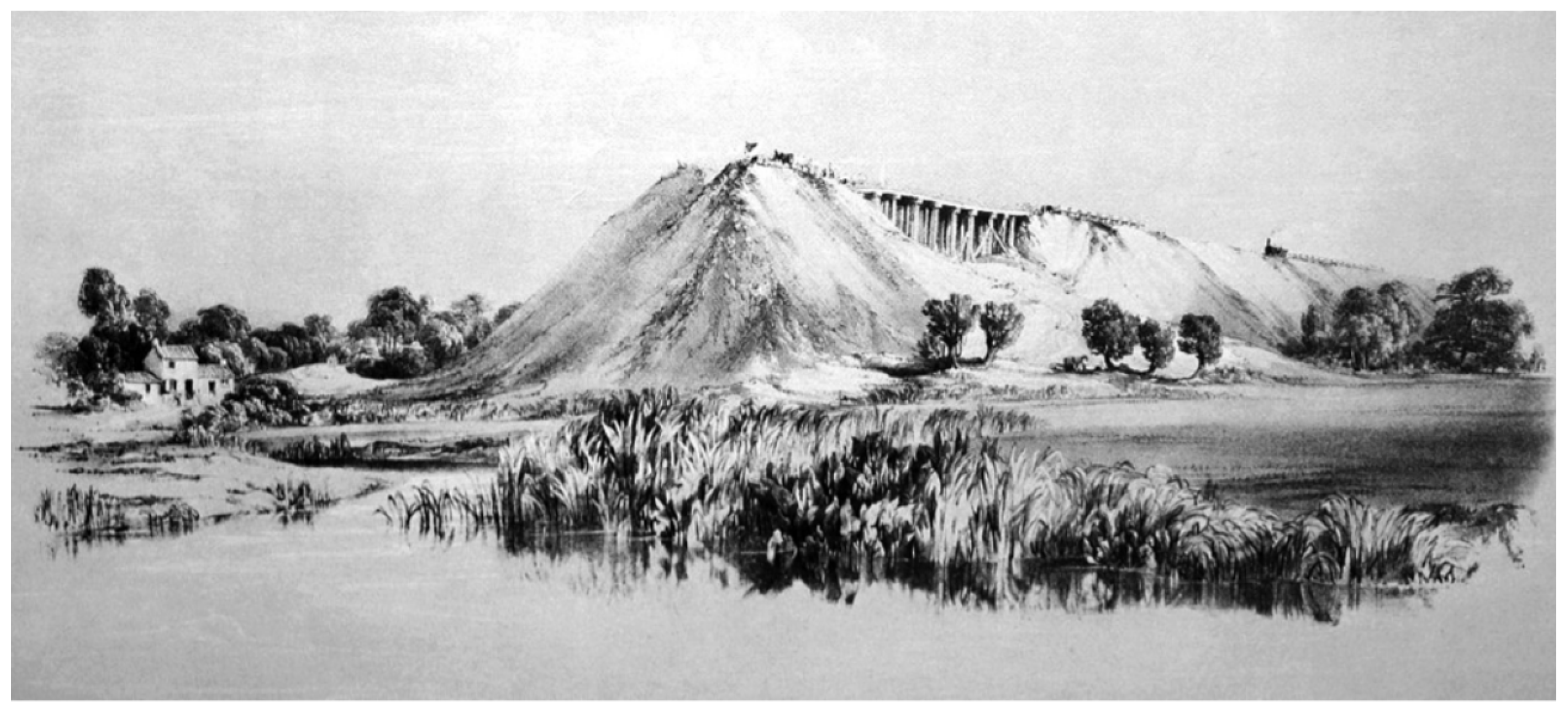
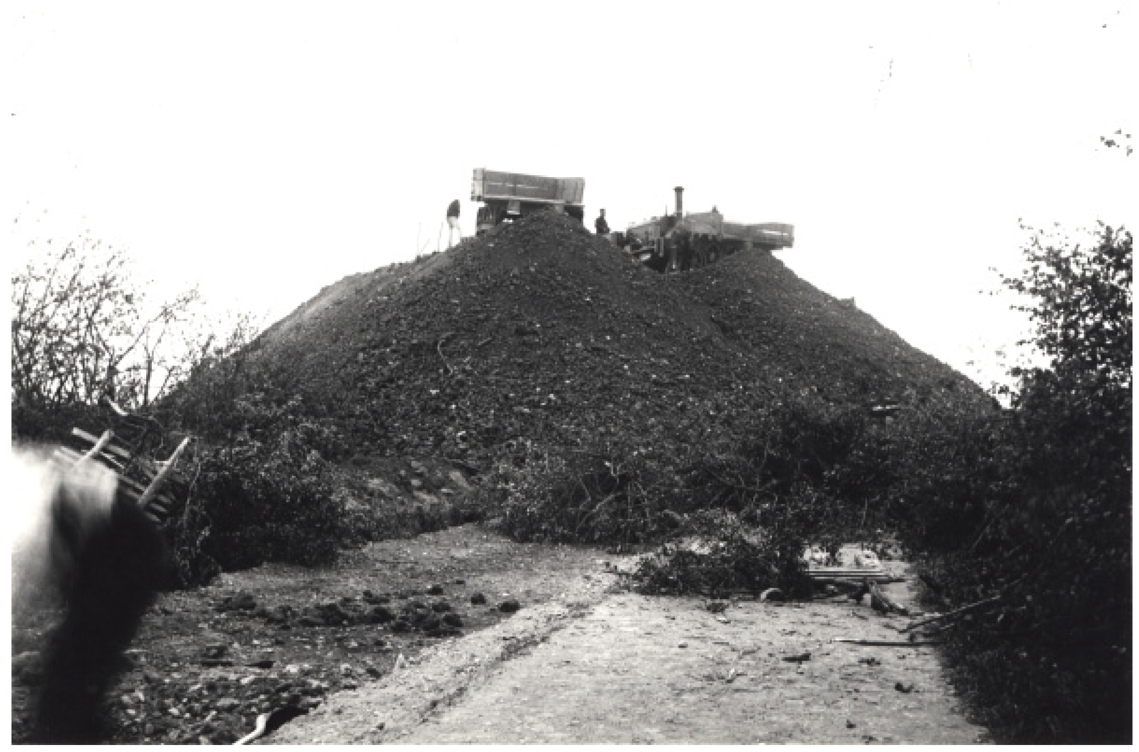
2.1.1. Railway—19th and Early 20th Century

During the 1830s/1840s, nine mainline railways were empirically designed and constructed in the UK, totalling 660 miles, and included 54 million m3 of earthwork material [1]. Their construction characterises the methods used during the 19th century. Compaction techniques were used in the construction of roads, which were normally built at grade. In the case of the rail network, compaction was only conducted at abutments to avoid differential settlement between the rigid abutment structure and the approach embankments [14]. End-tipping was used as a cost- and time-saving measure to construct the embankments, and often comprised of a singular lift in which horse-drawn earth wagons tipped the fill material from the advancing head (Figure 1 and Figure 2) [14]. This resulted in a number of failures during construction (Figure 1) [1]. Embankment settlements were large but their effects were mitigated by speed restriction and packing of ballast or locomotive ash beneath sleepers until movement subsided [3].
The fill material was typically taken from adjacent cuttings as a balance of cut and fill was ensured. This was a time-saving measure which allowed large volumes to be transported over short distances for embankment construction, rather than sourcing more suitable material from borrow pits [1]. No foundations were prepared. In many cases, embankment construction was undertaken without the removal of topsoil and other soft superficial deposits [5].
At this time, side slopes were covered in vegetation, and lineside fires stemming from embers emitted from passing trains somewhat controlled its growth. Over time, vegetation became mature and increased in density; therefore, measures were put in place to control the likelihood of lineside fires with regular maintenance. This was important, as it would have altered the dynamic balance between the beneficial and detrimental effects of vegetation on embankment stability and serviceability [21]. For example, a significant reduction in the density of vegetation may have a positive effect on stability for highly plastic geostructures (soils with large water content range in the plastic state), due to a decrease in seasonal soil moisture changes and therefore a reduction in differential movement along embankment crests [3]. However, this management approach also reduces surface shielding (which would result in an increase in both surface erosion and permeability), root reinforcement, and negatively impact ecological and environmental conditions [21].
Thereafter, in the early 20th century, Proctor [22] introduced modern compaction methods for dam construction. They were based on achieving soil compaction to its maximum dry density at its optimum moisture content, which could be validated using a standard compaction test. By 1936, mechanised plant (e.g., bulldozers and scrappers) were used in the UK to form a compacted embankment fill for Chingford dam [13]. In addition, Atterberg [23] introduced consistency limits, further developed by Terzaghi [24] and Casagrande [25] for use in soil selection. The Transport Research Laboratory was also established in 1933, and in 1948, BS 1377 was published, which included guidance on the use of Proctor compaction testing [13].
The relationship between the beneficial and detrimental effects of vegetation continued in the early 20th century. Lineside fires still posed some risks; therefore, regular maintenance of vegetation by ‘lineside gangs’ continued. This included techniques such as grass scything and tree coppicing. Gellatley, et al. [21] also noted that earthwork slopes on the London Underground were subject to regular burning, resulting in increased grass cover as fires eliminated any young vegetation preferentially.
During this period, earthwork construction on the UK railway network still remained largely empirical. For instance, an intrusive investigation of London Underground (completed circa 1930) by Mcginnity, et al. [4] showed that embankment construction continued with minimal compaction effort. Embankments were often built directly on virgin ground, i.e., topsoil was not removed, there was no ground improvement, and foundations were not routinely considered. This resulted in failures during construction and large settlements post-construction [4].

2.1.2. Highway—19th and Early 20th Century

Construction of turnpike roads (non-government toll roads) provided the first opportunity for standard empirical road construction methods, one of the most notable being John Loudon McAdam (1756–1836) [13].
McAdam’s system incorporated drainage, ignored use of stone foundations, and included a 30 cm layer of aggregate stone broken up and compressed by passing traffic [26]. This technique was adopted worldwide due to its speed and low cost; however, the advent of the automobile meant a gravel surface, and the lack of firm foundations was not suitable for large vehicles [13]. During this early period of road construction, earthworks were less commonplace due to the ability for roads to be constructed at steeper gradients owing to the small traffic loads and slower speeds (compared to the present day). Prior to the mid-20th century, roads followed the contours of the land known as ‘sidelong ground’, and therefore, earthworks were avoided where possible [5]. Some roads, constructed for horse and cart traffic, contained substantial earthworks in rural hilly areas. However, it was not until the construction of the first major highway (motorways) where lengths of continuous embankments were constructed [27].
Along with the advent of automobiles in the early 20th century, the structure of roads changed to accommodate a faster method of transport, but the fundamentals remained much the same as the previous century. The most significant development stemming from road infrastructure construction was the introduction of the California Bearing Ratio (CBR) by Porter [28], which could be used to assess the thickness of subbase for a given subgrade strength and traffic load. The test was developed in the 1930s by the California Division of Highways to quantify subgrade strength by comparing its bearing capacity with a well-graded crushed stone with a CBR value of 100%. Due to its economic, simple procedure, the test has continued to be adopted for earthwork and pavement construction [29].

2.2. Post-Regulation

In the latter half of the 20th and 21st century, several pivotal regulations, based on evolving scientific understanding of soils, were standardised for all earthworks including roads and railway, as follows [30]:
  • 1951—Specification for Road and Bridge Works introduced ‘end-product’ criteria
  • 1959—BS 6031 set out the code of practice for earthworks
  • 1969 and 1976—Specification for Highway Works (SWH) introduced ‘method compaction’
  • 1975—BS 1377 was updated with new testing procedures
  • 1986—SHW included various updates to end-product criteria, method compaction, and fill suitability selection
  • 2004—Eurocode 7 (EC7) European standards introduced into UK practice
  • 2009—BS 6031 Code of Practice for Earthworks fully updated to reflect modern methods and EC7
  • 2021—Underlying principles of the current SHW remain unchanged after the various updates in the 1970s and 1980s

2.2.1. Railway—Mid 20th and 21st Century

Along with the rise of the automobile, major railway construction slowed in comparison to construction of highways. However, due to the transition from steam power towards combustion engines and electricity for propulsion, vegetation growth became an increasing issue. For example, with the electrification of the London Underground and introduction of diesel engines, there was a decrease in the risk of lineside fires caused by the embers deriving from coal-driven locomotives. This therefore resulted in reduced maintenance efforts. By the late 1960s, most traditional vegetation controls were terminated and replaced with simpler herbicide treatment to control vegetation on and around the tracks themselves [31]. This led to vegetation growth on earthworks banks, which over time was allowed to mature and diversify, leading to several issues including [21]:
  • disturbance of substructure and tracks,
  • fallen branches,
  • fallen trees,
  • loss of traction owing to leaf fall,
  • settlement or heave of over-consolidated clay soils (plastic clay fills),
  • penetration or blocking of drains and ditches.
This resulted in inefficiency and disruption to running services and thus the subsequent publication of vegetation specifications in the Landscape Management Handbook [32] for highways and Network Rail standards. Despite this, the conflict between management/removal of vegetation and potential instability (or beneficial/detrimental impacts), particularly in plastic clay fills, still poses issues. For instance, London Underground now recommends vegetation removal in the upper part of an embankment slope. This is designed to maintain stability but minimise disruption due to plasticity of the London Clay soils [33]. The interest in these beneficial aspects was landmarked by the CIRIA publication ‘Use of Vegetation in Civil Engineering’, which introduced the concept of enhancing soil properties with vegetation [34].

2.2.2. Highway—Mid 20th and 21st Century

The Preston By-Pass was the first motorway built in the UK to highway standards and was completed by 1958 [35]. Due to the increased speed of traffic, a low gradient was required (approximately 1 in 25), which necessitated the implementation of extensive earthworks [5]. The earthworks were constructed to the Specification for Road and Bridge Works, which formalised compaction to an ‘end-product’ criterion by setting a required percentage of dry density to be achieved during testing [35]. Early highways were constructed with 8-ton deadweight rollers, including vibratory rollers by 1976 (SHW edition 5), which later became more commonplace [13].
The construction of the Preston By-Pass took place in glacial tills and alluvial sands and silts. Due to the new specification, material was still sourced from cuttings but now exceptions were made for material deemed ‘unsuitable’. The Ribble Valley contained peat bogs and was found to be of insufficient bearing capacity for embankment construction despite the initial assumption that all excavated material could be reused. Furthermore, due to exceptionally wet weather conditions, excavated material was discarded and replaced with imported fill [36]. These weather conditions also produced instability of cut slopes due to surface runoff, delaying the project [35]. In total 3,400,000 imperial tons of earth was excavated, and a further 668,000 imperial tons was imported for fill [37]. This approach to construction therefore produced more homogeneous fill material compared to past construction techniques, particularly the rail network.
Modern earthwork construction on highways continued at a rapid rate between the 1960s and 1990s, with various improvements made to specifications [5]. This led to a design-based approach, which vastly improved on pre-regulation empirical construction. This largely underpins modern earthwork design with BS 6031 Code of Practice for Earthworks, which introduced the identification of problems such as soft cohesive soils or peat during ground investigation and remediation practices. In addition, in the early 1960s, excess capacity in the chemical industry led to manufacture of geotextiles for use in construction. At this time, their main function was for separation and infiltration between natural ground and fill [38], but further development meant that they could be used as reinforcement in engineered soils.
In contrast to the railway network, motorways have implemented vegetation standards since the 1950s. Consideration for grass establishment was made by introducing a grass dominated topsoil layer with partial management to remove trees. In comparison, railways contains a more mixed mature line side vegetation owing to natural seeding [33]. This means that the relationship between the beneficial and detrimental effects of vegetation, and thus impacts of climate change, are vastly different on the railway network in comparison to highways in the UK

2.3. Current Regulations

Due to the recent increased recognition of climate change, it is now being considered in the construction and management of the UK transport network. Both Network Rail and Highways England have developed strategies to increase resilience of their networks, which are showcased in the ‘Highways England Climate Change Adaptation Strategy’ and ‘Network Rail Climate Change Adaptation Report’, respectively [39,40]. Moreover, more emphasis is being put on the consideration of lineside and roadside ecosystems and its incorporation into design standards [41]. For example, Network Rail has reduced its use of herbicide glyphosate by 25% since 2008 [42]. It is probable that these changes to vegetation management are again likely to have an effect on the diversity and density of lineside vegetation in the future.
Furthermore, it is evident that the construction history of highways and railways is extremely distinct. Table 1 provides a summary of these differences when examined with reference to both pre-regulation practices (railway 19th and early 20th century) and post-regulation practices (railway and highway between 19th and early 20th century). It shows that construction techniques are particularly important to consider for the railway network due to the presence of older structures, often built before the implementation regulation. These structures therefore may produce areas of localised increased vulnerability to the impacts of climate change. This is also being considered and is a prominent part of Network Rails earthwork management review and earthworks technical strategy [9,15].

3. Geostructures Vulnerabilities

The performance of geostructures on the transport network is related to the interactions between the atmosphere and subgrade (Figure 3). For the UK rail network, it also directly links back to the construction history of a chosen geostructure. For instance, Loveridge, et al. [2] reported the presence of variable permeability for clay fill due to embankment age and therefore construction techniques. This variation is important to consider as the degree of permeability impacts the pore pressure/atmospheric response of a structure. In addition, variability in the quality of the fill material (again linked to its construction history) is also an important factor for the resilience of compacted soil. This was demonstrated by O’Brien [43] using numerical modelling, where the inclusion of soft alluvial clay lenses within London Clay embankment fill material and small changes in maximum winter pore water pressures significantly decreased the number of shrink–swell cycles required until slope failure.
Despite this, Loveridge, et al. [2] suggests that due to the likelihood of increased future evapotranspiration in certain future scenarios (i.e., where Very High Water Demand (VHWD) trees are situated), infiltration may be reduced and an increase in surface run-off may be predominant. Although counterintuitive, this demonstrates the complexities of contrasting stabilising and destabilising forces produced by the interaction between the atmosphere, clay fill, and vegetation. An understanding of this is important, as generally in design it is assumed that saturated soil under hydrostatic conditions is the ‘worst case’ scenario. However, when evaluating the relative risk of comparable embankments, this assumption is overly simplistic, as a myriad of factors are involved, often dealing with unsaturated soil mechanics. This also includes factors which add further complexity and are both transient and highly variable—i.e., the soil microstructure and its behaviour dependency on seasonal variation in climate. Loveridge, et al. [2] suggests a list of several further important factors, including the following:
  • plasticity,
  • susceptibility to erosion and degradation,
  • vegetation type and distribution,
  • permeability and permeability contrasts,
  • underdrainage and ‘hidden defects’ (relict failures, or pockets of different permeability).
Loveridge, et al. [2] further suggested that permeability and vegetation may be of most significance due to their role in formation of pore water pressures, but are not considered in routine site investigations, risk assessments, or analysis. O’Brien [43] drew similar conclusions, adding that permeability and vegetation directly relate to the development and evolution of seasonal pore water pressures, which ultimately control stability. This was most intuitively shown by Briggs, et al. [45] using VADOSE modelling of a railway embankment with Newbury weather data for 2005/2006 (where the Soil Moisture Deficit varied between 0mm and 150 mm). The results of sensitivity analyses showed that upon tree removal in the upper two-thirds of the slope, much larger positive pore water pressures (where soil pores are fully saturated and thus greater than atmospheric pressure) formed during the winter in the near-surface (upper 2 m). However, negative pore pressures (where soil pores contain both air and water phases, generating pressures less than atmospheric pressure) were maintained at depth. It was also determined that clay fill permeability within a critical range between 5 × 10⁻⁸ m/s and 5 × 10⁷ m/s had a significant influence on the formation of pore water pressures.
Similarly, Loveridge, et al. [2] also suggests that the permeability of railway embankments are closer (than highways embankments) to ‘a band of critical permeability’. The critical permeability corresponds to UK average rainfall rates and was identified as being 1 × 10⁻⁷ m/s (i.e., soil permeability which allows water to enter a slope at a sufficient rate during periods of rainfall). This is likely the result of reduced compactive effort on historic railway embankments, but also the presence of tree roots (due to mature growth of vegetation on railway embankments in mid-20th century) and desiccation cracking [2]. As a result, it is probable that water is able to percolate more deeply into historic embankment as opposed to running off the surface, producing increased pore water pressures. This concept is further complicated by the presence of unsaturated conditions, which influences the permeability of soils. O’Brien [43] showed that the formation of positive pore water pressures in the near-surface is highly dependent upon the Soil Water Retention Curve (SWRC), as slight changes in negative pore pressures, and thus the degree of hysteresis (difference in negative pore pressures between wetting and drying curves), has a significant effect on unsaturated permeability.
In situ testing has demonstrated the implication of these factors on embankment pore pressures. The most notable is the Achilles Bionics test embankment [46]. A full-scale model embankment was constructed in glacial till considering different densities and capping fill materials. The observations made over time in this field embankment demonstrated that change in compaction level, and therefore permeability, had a significant impact on the variability of both negative and positive pore water pressures [46]. In addition, field monitoring of negative pore water pressure, undertaken by Toll, et al. [47] at Boissy-le Châtel, France, further demonstrated the hysteretic nature of pore water pressures. Monitoring took place at depths of 0.25 m and 0.45 m between May and June 2004. It was shown that the change in negative pore water pressure was greater at 0.45 m than 0.25 m after four separate rainfall events. Toll, et al. [47] attributed this to hysteresis, as the upper 0.25 m was closer to the bounding wetting curve compared to 0.45m depth, resulting in a greater loss of negative pore pressure at 0.45 m. Deeper in situ pore water pressure measurements made by Ridley, et al. [48] of London Underground historic embankments between March and August 2001 demonstrated the complex effect of contrasting permeabilities. It was shown that, under drainage resulting from high permeability, foundation material produced conditions which reduced positive pore water pressures at depth. The results of Ridley, et al. [48] and the data collection and interpretation made by Briggs, et al. [45] are shown in Figure 4. The contrasting pore water pressure profiles for an initially uncompacted stiff clay overlying stiff London Clay, chalk, and coarse-grained soils is evident, with embankments overlying stiff London Clay trending much closer to hydrostatic pore water pressures within the same period of time. This research thus highlights that compaction conditions, hysteresis of the near surface, and foundation drainage conditions (which are highly influenced by construction history) can alter the pore pressure profile of a geostructure and therefore affect its vulnerability to the effects of climate.

4. Failure Mechanisms

The combination of climate, resultant pore pressures, and relict vulnerabilities owing to construction methods, such as end-tipping (prominent on the railway network), have led to infrastructure failures, most recently the Stonehaven train derailment in August 2020. In response to this, Network Rail appointed a Task Force led by Professor Lord Robert Mair to compile a report with the aim of reviewing asset management in light of climate change. The Network Rail [9] review details the most recent industry experience and observations. Table 2 summarises the most significant findings of the report relating to failure mechanisms. It presents the relationship between both failure mechanisms and vulnerability to climate, identifying four main failure types including deep-seated failure, shallow translational failure, washouts, and debris flows.
The report demonstrates that both deep-seated and shallow translational failure types are directly related to the interaction of climate and geostructures over extended periods. Research has shown that seasonal cycles of pore water pressures (in the near-surface) in clay embankments produces a progressive deep-seated failure mechanism. This is most notable for embankments in the midlands and southern England in stiff overconsolidated sedimented clays, where soil plasticity is higher in comparison to Devensian glacial tills found more commonly in northern parts of the UK. Numerical and centrifuge modelling has also demonstrated that a ‘ratcheting’ effect of seasonal pore water pressures takes place, where outwards deformation during winter is only partially recovered by shrinkage during the summer [49]. This type of failure has been shown to develop at the toe of a slope and propagate to the centre under repeated hydraulic stress cycling. This results in a non-uniform distribution of strength where the toe of the slope is at residual strength and the crest at peak strength (Figure 5). Importantly, it was found the permeability of the clay fill material controls the number of cycles to reach failure [50].
Deep-seated failure mechanisms have also been attributed to historic construction practices. This generally results from over-steepened cut slopes and embankment gradients and the presence of relict failure surfaces, particularly in cuttings. This produces highly localised vulnerabilities, which exacerbate geotechnical risk, especially with respect to climatic changes.

5. Climate Change

Historic geostructures will experience future changes in climate, including changes in seasonal patterns of precipitation and drought owing to increases in surface temperature. These predicted future surface temperature changes are based on several scenarios designated as Representative Concentration Pathways (RCP) [51]. RCPs are split by a range of radiative forcing values found in the literature resulting from prediction of internal drivers such as greenhouse gases against a preindustrial baseline, at the year 2100 [52]. Radiative forcing concerns the net change in radiative flux in the upper atmosphere, expressed as Watts per square meter [53]. The surface temperature change and assumptions for each of the radiative forcing pathways is presented in Table 3. It clearly demonstrates the indeterminate but probabilistic nature of future temperature change and thus the need to factor these probabilities into infrastructure management and design.
The understanding of the impact of climate change in the UK began with development of the Climate Change Impacts Review Group (CCIRG), which produced CCIRG91 followed by CCIRG96, in both 1991 and 1996, respectively. Subsequently, in 1998, the UK Climate Impacts Programme (UKCIP) was developed and published the UKCIP98 report. Unlike the original work, UKCIP98 produced climate scenarios which were aimed at assisting with national assessments of the impacts and adaptation to climate change [54]. Thereafter, UKCIP02 scenarios produced higher spatial resolutions based off four IPCC storylines [54]. More recently, UK Climate Projections (UKCP) have been published beginning with UKCP09 scenarios in 2009. This approach allowed for future climate to be quantified in probabilistic projections used for understanding uncertainty required for adaptation [55]. UKCP18 represents the most recent generation of these climate models, although as UKCP09 predates UKCP18, UKCP09 is found within much of the literature prior to 2018.
UKCP18 builds on past predictions and provides a more precise spatial resolution [8]. The analysis predominantly agreed with the previous studies, showing (for a high emissions scenario RCP 8.5) that by the year 2070, the UK climate will experience more climatic extremes. It predicts increased seasonal temperatures for both winter (warming range of 0.7 °C–4.2 °C) and summer (warming range of 0.9 °C–5.4 °C). An increased frequency of hot spells from once every four years to four times every year. Average winter precipitation is projected to increase by 35% and summer rainfall is expected to decrease by 47%. Finally, a 25% increase in the likelihood of extreme hourly intense rainfall is also projected. This is represented in Figure 6, which shows the observed and future predicted changes for temperature and precipitation in the UK [8]. Despite the quality of the research into UK climate change, there are several limitations which must be noted. This is explicitly outlined by the Met Office for the predicted future UK weather conditions made in UKCP18 and can be summarised as follows [8]:
  • the results are dependent on assumptions made in the RCPs—future pathways may be different or more complex than expected,
  • probabilistic projections depend upon several statistical dataset assumptions which are made using expert judgement and may change,
  • global climate models have greater confidence for long-term climate averages than extreme events,
  • climate projections will evolve with time as modelling methods are improved and computer power is increased.
As a consequence, the predicted range of climate data outcomes for different future climate scenarios produced by existing models require further consideration. This is especially important for extreme event patterns, which have a significant influence on the performance of earthworks and built geostructures. However, there seems to be an agreement among several past studies that future climate trends resulting from climate change will influence future in-service performance of geostructures, though the associated effect and magnitude of the impacts remains uncertain.

6. Impact of Climate Change on Transport Infrastructure Assets

Climate changes are expected to yield several transient and spatially complex effects on the geotechnical performance of the transport infrastructure network. Recently, a European Cooperation in Science and Technology (COST) Action TU1202 workshop was designed to reflect on the issues and research developments for the European transport infrastructure network [7]. Several important aspects of the climate problem are illustrated in Figure 7 and were outlined by Tang, et al. [7]:
  • the impact of climate change on the European subcontinent will vary with location; the northwest being affected most greatly by increased winter precipitation, soil water content and therefore rainfall induced slope instability, while the Mediterranean region is expected to experience larger temperature rises compared to the European average and reduced annual precipitation,
  • increased surface runoff may result in external erosion owing to the loss of vegetation during drought periods (this requires consideration for future drainage design),
  • desiccation will increase infiltration resulting in increased pore pressure response and internal erosion,
  • the impact of shrink swell in plastic soils will increase due to the cyclic nature of wetter winters and drier summers,
  • the frequency of these shrink swell cycles may also increase due to summer storms (which will intensify progressive failure mechanisms),
  • saturation, resulting from increased average rainfall and extreme events, in combination with the above factors will increase the pore water response in winter months.
Figure 7. Cross-section of a railway embankment showing the impacts relating to changing climatic patterns associated with climate change and seasonal variation of water content and temperature with depth along the centre line, modified after Heitor et al. [56].
Applsci 12 07461 g007
Some of these factors have been previously investigated by Clarke, et al. [57] using numerical modelling based on UKCP09 predictions, focusing on the UK and its predicted future climate. They showed that future climate change will likely have a significant effect on the soil moisture of geostructures incorporating clay materials. They found that the soil moisture deficit range would increase, particularly in the southeast of England. This was mainly attributed to an increased loss of moisture during the summer months, resulting in a larger winter to summer wetting–drying cycles (Figure 7). It was therefore surmised that a London Clay slope, for example, would undergo increased desiccation and a resultant loss of vegetation as it reaches the wilting point (the minimum amount of soil moisture required for a plant to no longer wilt). It would also experience increased shrink–swell and erosion due to surface runoff resulting from the lack of vegetative protection.
As a result, it is likely that wetting–drying cycles will become the most prevalent process underpinning the performance of built geostructures. Nonetheless, the consideration of freeze–thaw processes is critical for northern colder locations. For instance, as the average yearly temperature continues to rise, so too the number of the days the ground remains unfrozen [58]. This indicates that geomaterials may be experiencing more frequent thawing which undoubtedly influences their behaviour. A recent study examined the role of cyclic freezing and thawing processes in unsaturated soils [59]. The results showed that different behaviour of unfrozen water during freezing is observed for sand and silt. Sand media is conducive to the formation of ice lenses, but the frozen soil remains close to its original state, and it recovers its original state upon thawing. In silt media, there is ice formation within the pores, which results in a change in the void ratio of the soil. Consequently, the soil behaves normally, consolidated as cycles of freezing and thawing progress. For materials susceptible to crushing, Ishikawa, et al. [60] reported that freeze–thaw action has a strong influence on the hydraulic and shear strength behaviour of volcanic coarse-grained soils, e.g., increase in water retention capacity and a reduction in shear strength and deformation modulus.
Empirical evidence of the impact of climatically induced hydraulic processes on geomaterials was recently illustrated on the rail network. In a tragic event, which occurred on 12th August 2020, three people were killed after a train derailment between Aberdeen and Glasgow, near Stonehaven (Figure 8). This rail incident further emphasised the need to proactively manage the impacts of climate change on historical transport infrastructure assets. The incident report postulated that the cause of the derailment was associated with a washout from the adjacent cutting, which was a result of a period of heavy locally intense rainfall and thunderstorms [10].
Undoubtedly, the performance of the geomaterials that incorporate typical transport infrastructure substructure under partially saturated conditions is also influenced by the magnitude and frequency of the dynamic loads applied. However, the timescales in which the processes (traffic loads versus moisture changes) take place are quite different and thus can be decoupled (e.g., Zhu, et al. [61] and Heitor, et al. [44]). This is because dynamic loads are applied over seconds/minutes (depending on the traffic speeds) compared to days/months for the hydraulic processes. Nonetheless, during dynamic load application, irrecoverable deformation can cause a change in the degree of saturation and suction, which in turn influence the behaviour of the compacted materials (e.g., Khalili, et al. [62]). In this paper, the focus is on the hydraulic processes that take days, months, and years, as illustrated in Figure 7.

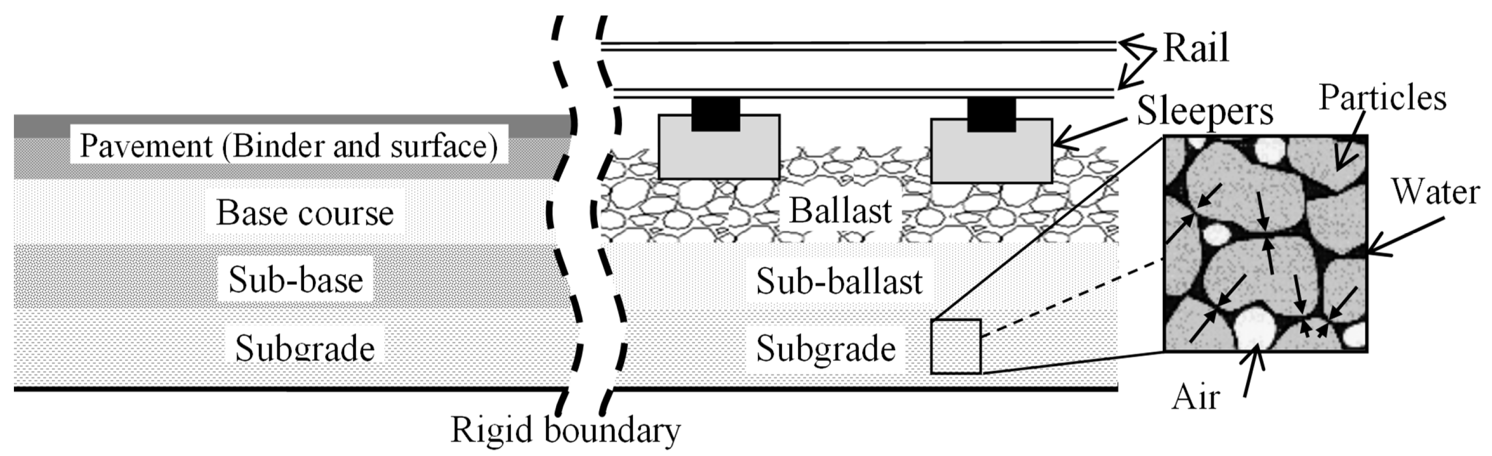
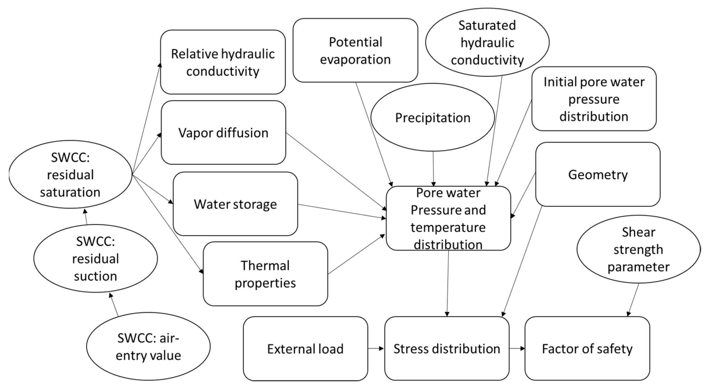
7. Soil–Atmosphere Interaction Research Methods

The UK’s historical geotechnical infrastructure experiences several changes between saturated and unsaturated states annually, which impact behaviour of the soil. The issue can be conceptualised using a framework of unsaturated variables set out by Gitirana [63], which are useful to consider when designing an investigation into the interaction of geostructures and weather-related geohazards. The flow diagram in Figure 9 outlines their relationship to the Factor of Safety (FOS). The square boxes represent ‘fixed’ values while the circular boxes are ‘uncertain’ variables. This approach demonstrates the considerable quantity of complex interactions between unsaturated soil variables required for assessing slope stability.
It is notoriously difficult to test these complex soil–atmosphere interactions in the laboratory in a truly representative manner. Furthermore, the interaction of these factors with the soil fabric provides further complexity which is difficult to capture and measure. Therefore, it is generally considered that full-scale embankment testing is a more representative approach. This was shown by Glendinning, et al. [64], where laboratory permeability tests were a magnitude lower than the in situ equivalent. This was a result of the absence of macroscale structures (desiccation cracks and plant roots) in laboratory samples. It also resulted from both sampling time (a three-year gap between laboratory tests and in situ testing was recorded) and differences in testing depth (laboratory samples were retrieved from 2 m depth below crest, whereas in situ tests were taken at 0.3 m and 1.4 m).
The Bionics test embankment in northeast England was constructed to circumvent this problem and allow for field monitoring of soil behaviour on a full-scale embankment [46,65]. The testing regime included permeability testing, pore water pressure monitoring, and Electrical Resistivity Tomography (ERT) [65,66,67]. The results were able to demonstrate the heterogeneity of pore water response within the embankment owing to prevailing wind direction, vegetation type, capping type (surface permeability), and compaction conditions [64]. This approach allowed for the investigation of both micro and macro structures that element testing alone would not allow. Despite this, monitoring was limited temporally, as to consider seasonal variation (soil-atmosphere interaction) and temporal changes in soil fabric, years of data collection are required. Furthermore, the number of monitoring points in terms of depth and spatial distribution, as well as the occurrence of uncontrollable variables such as pooling water on the slope surface, provide additional limitations [64]. Moreover, in the wider context of the transport network, the spatial variability of historical geostructures (including their construction materials and techniques) produces an additional layer of complexity which is difficult to evaluate. These limitations make it challenging to come to absolute conclusions owing to variability at all scales, especially for prolonged conditions.
The limitations of full-scale testing are partially mitigated using physical modelling techniques. A prime example was reported by Take, et al. [68] with regards to seasonal climatic cycling of hydraulic stresses on a centrifuge model and limit–equilibrium back analysis. This approach allowed the problem to be scaled down in its entirety, including temporally, to account for numerous seasonal variations. Their testing reported the ‘ratcheting’ effect of seasonal volumetric changes, measured using vector displacements propagating from the toe of the embankment. This has a significant advantage, as negative pore water pressures could easily be measured using a small number of high-capacity tensiometers placed in the slope face. Furthermore, a scaled calendar year of seepage flow was completed in only 2.43 h. However, this approach was also limited, as many of the micro- and macro-structures were disregarded, as such pore water response is somewhat simplified. Nevertheless, the research highlighted its application when analysing the use of limit–equilibrium methods for better evaluating long-term stability.
In addition to full-scale and physical modelling, numerical analysis has been employed by several researchers to undertake sensitivity analysis using boundary flux parameters. A novel application of numerical modelling was presented by Stirling, et al. [69], where desiccation crack formation was modelled in FLAC 2D using laboratory data from the Durham Boulder Clay. This allowed for a sensitivity analysis of crack formation during drying to be completed. It was shown that sensitive materials with high plasticity and thus larger Air Entry Values (AEVs) were more likely to exhibit pervasive fine cracking patterns, while glacial tills were more likely to exhibit permanent deeper cracks. This approach allowed for a reduction in laboratory testing, as changes in soil properties could simply be inferred from baseline tests. However, this smaller-scale, concentrated approach to modelling means that the interaction of these findings with the mechanics of a slope (pore water pressures) must be inferred rather than quantified.
Testing of soil–atmosphere interaction at a laboratory scale is typically used to measure and observe several fundamental geotechnical properties. These tests are explicitly concentrated on a singular mechanism under controlled conditions, so the dependant variable may be quantified against its independent counterparts, often for modelling and design purposes. Work published by both Mendes, et al. [70] and Azizi, et al. [17] demonstrates this with efforts to understand the effects on variation in hydraulic stresses on unsaturated compacted soils. Azizi, et al. [17] undertook measurement of permeability, volumetric changes, pore structure, and unsaturated shear strength after six hydraulic wetting and drying cycles on samples of compacted clayey silt. In comparison, Mendes, et al. [70] investigated the effect of compaction water content (an additional variable) under similar conditions, also observing its impacts during unsaturated triaxial shearing. Both researchers demonstrate the ability for laboratory testing to allow for controlled analysis of unsaturated soil variables with various hydraulic histories, which is not possible at a field scale. However, somewhat similarly to field testing, the increased testing time and complexity required for measuring the behaviour of unsaturated soils, pertinent to soil-atmosphere interaction, somewhat limits the scope of the work.

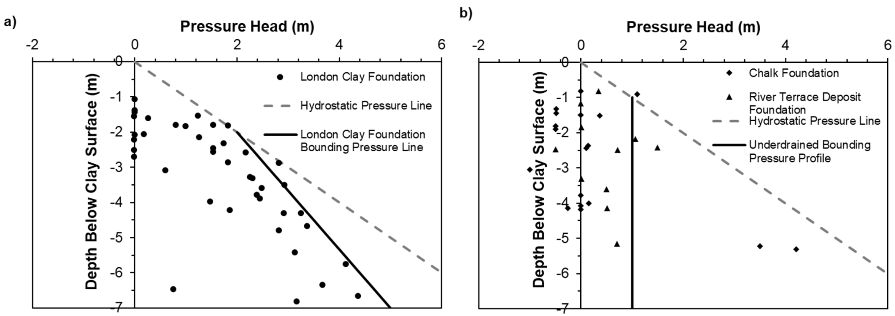
8. Impacts of Hydraulic History on Compacted Soils
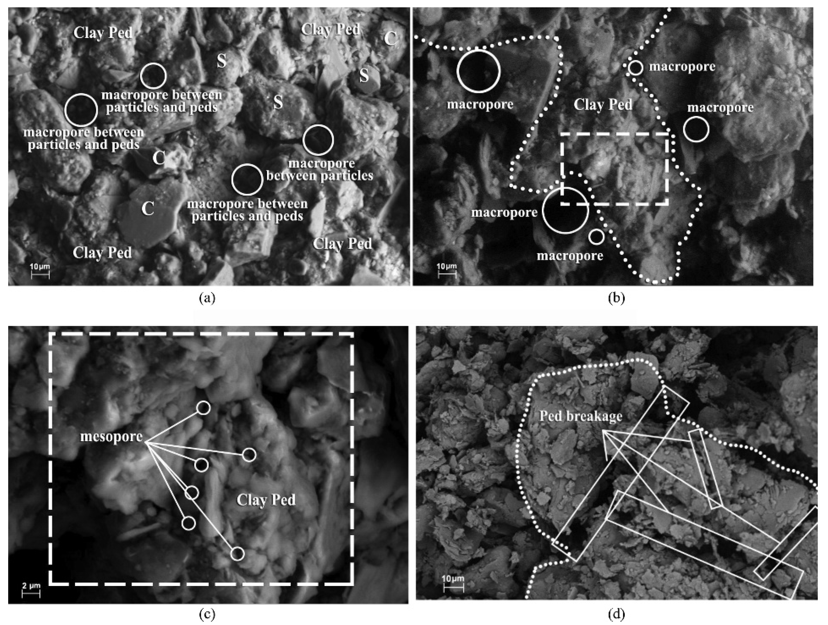
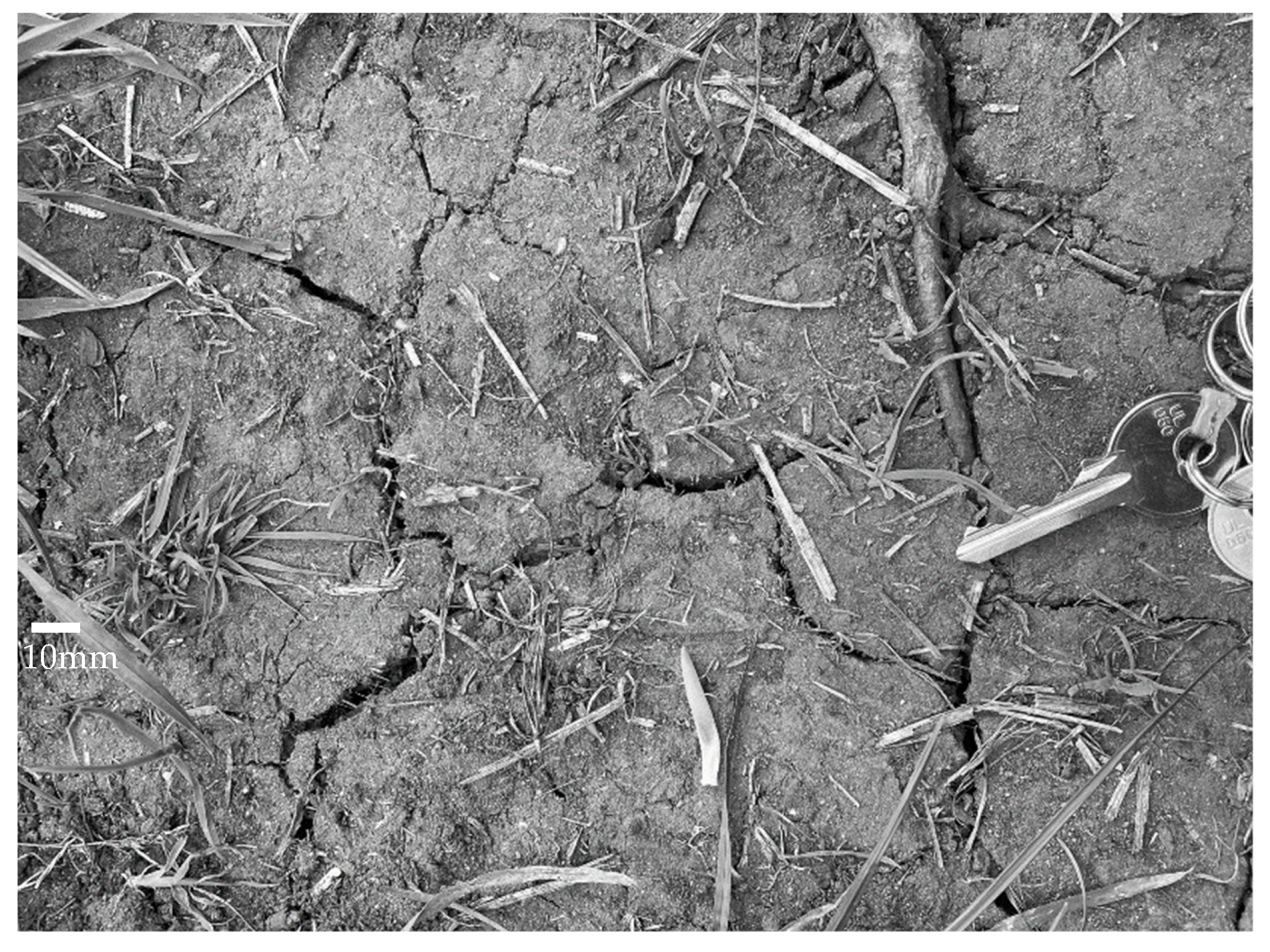
The impact of seasonal variation and therefore pore water pressure on compacted soils used in transport infrastructure has shown to reduce its performance over time. This has been classified using a performance curve, shown in Figure 10. It shows a comparison between the performance of embankments under different climatic conditions and construction histories. It also shows the performance of current transport infrastructure geostructures in the UK, based on construction methods, i.e., pre- and post-regulation techniques.
Although no direct measurement has been made recording this change in performance, due to obvious constraints, it provides a theoretical framework from which to evaluate geostructures present on the transport network. Evidence supporting the hypothesis presented by Briggs, et al. [71] (Figure 10) derives from the influence of cyclic changes in pore water pressure due to climate. A conceptual model reported by Stirling, et al. [19] (originating from laboratory and field testing) detailing the process of weather-driven deterioration on compacted clay fill explains this reduction in performance. The stress–strain behaviour of a compacted glacial till was studied once specimens were subjected to several hydraulic stress cycles within a defined range of water contents. The results showed that after three cycles, an equilibrium was reached producing an asymptotic reduction in strength (Figure 11). The use of an ESEM (Environmental Scanning Electron Microscope) imaging by Azizi, et al. [17], shown in Figure 12, captures the formation of micro cracks, which propagated during hydraulic cycling due to tensile stresses resulting from negative pore water pressures.
The response of the soil to this hydraulic history was attributed to the formation of irrecoverable hysteresis. This implies that negative pore pressures vary depending on the density of micro cracking, i.e., negative pore pressures reduce over time at a specific saturation as micro cracks form. Figure 13 shows an illustration of a typical hysteretic SWRC. It includes an initial drying curve, main wetting curve, and main drying curve. The main wetting and drying curves form the ‘main’ hysteresis loop. An infinite number of scanning curves can also form within this boundary. The formation of micro cracking, and thus changes in the pore structure, means this hysteretic loop is permanently altered as the Air Entry Vale (AEV) decreases with increasing density of micro cracks.
These changes result in an immediate increase in the permeability of the soil–atmosphere interface, which is thought to thereafter continue at a slower rate. This yields time-dependant changes to the rate of infiltration and evaporation experienced by a geostructure. The magnitude of this change was also deduced to be dependant on the range of wetting and drying cycles. As a result, it could be assumed that more extreme weather conditions owing to climate change may result in greater microstructural changes of compacted clay soils (Figure 10d). When compared to recent construction, historic structures have experienced a greater (but unknown) number of hydraulic cycles of unknown magnitude, contributing to this process. This gives rise to the increased potential for both shallow and deep-seated failures; however, the critical degree of deterioration to cause this is also unknown.
Interestingly, research has shown that the degree of hysteresis between wetting and drying curves is linked to plasticity. Gapak, et al. [73] tested this relationship on compacted bentonites, where negative pore pressures were measured using a combination of Dewpoint Hygrometer and Vapour Equilibrium techniques for both initial drying and main wetting curves. During initial drying, highly plastic samples showed the greatest water content values and negative pore pressures, converging with lower plasticity samples above 5000 kPa. The relationship between negative pore pressures and water content of the main wetting path showed identical behaviour. It was also found that higher plasticity bentonites produced an increase in hysteresis, i.e., a larger difference between the wetting and drying paths. The relationship between the degree of hysteresis and liquid limit was shown to linearly increase. Gapak, et al. [73] suggest that this difference results from the micro structural differences in the soil, where higher plasticity clays have a greater number of micro pores due to the increase in clay fraction. It could be hypothesised that the same effect would be found during the formation of micro cracking and thus reduction in the AEV during cyclic wetting and drying from seasonal variation would similarly affect the hydro-mechanical properties of highly plastic clay fill.
The formation of hysteresis between wetting and drying paths has also been shown to impact the stress–strain behaviour of compacted soils. Goh, et al. [74] demonstrate this on statically compacted kaolin and sand using unsaturated triaxial constant suction (negative pore pressure) tests. When shearing on the first drying path, specimens showed a higher peak shear strength, higher axial strains at failure, more ductility, and contraction during shearing. On the other hand, when shearing on the first wetting path, specimens were stiffer and more brittle, had lower axial strains at failure, and showed dilation. This contrasted with the first drying path, which responded akin to a normally consolidated soil. This response remained present within subsequent wetting and drying tests as the magnitude of negative pore pressure was kept constant. It was therefore suggested that the negative pore pressures applied through wetting and drying acts as a pre consolidation pressure, which would need to be overcome to produce a different soil response, agreeing with findings by Stirling, et al. [19]. This is again pertinent due to the predicted increase in surface temperatures due to climate change. Hydraulic history is therefore a key component when understanding the performance of historic geostructures. It is clear that it has a strong influence on the behaviour of compacted soils, both by hysteresis between wetting and drying paths but also permanent alteration of the soil structure.
This has been reported in past research studies where soil behaviour was observed at small strains. Elastic properties at these small strains influences the response of geostructures to the application of repeated load transmitted from passing traffic [75]. Ng, et al. [76] and Ng, et al. [77] reported the impacts of wetting and drying on a completely decomposed tuff. They observed an increase in shear modulus ( G 0 ) during drying in a nonlinear fashion at a reduced rate when compared to the negative pore water pressure change. It was also found that hysteresis of negative pore water pressure, seen by the difference between the wetting and drying SWRCs (Figure 13), produced corresponding hysteresis in the shear modulus. At any suction, it was shown that the wetting path had a higher shear modulus when compared to the drying path. Similar results were also presented by Heitor, et al. [75] for a silty sand, which additionally showed an increase in the amplitude of the hysteretic shear modulus response to wetting and drying for lower compaction energy levels. Furthermore, Khosravi, et al. [78] reported that change in mean grain size D 50 shifted the SWRC left and reduced the negative pore water pressure, also reducing the rate of change of shear modulus during wetting and drying, while an increase in the coefficient of uniformity decreased the steepness of the SWRC due to the presence of finer particles and reduced hysteresis. This was attributed to elastoplastic hardening mechanisms, which is experienced differently depending on the wetting and drying path [79]. This mechanism was used to explain the increase in shear modulus during wetting (which is counterintuitive when considering the relationship between negative pore water pressures and degree of saturation) found by Ng, et al. [76]. This hysteretic response has also been suggested to results from changes in degree of saturation due to the ink bottle effect (resulting from nonuniformity of interconnected pores), changes in pore structure during wetting and drying cycles, differences in the liquid contact angle, air entrapment, and capillary condensation [80]. The hysteretic behaviour of unsaturated soils was highlighted by O’Brien [43], who made a point to emphasize the need to further develop practical guidance on the effect of hysteresis with regards to variation in permeability between unsaturated and saturated states.

9. Desiccation

The predicted increase in surface temperature is expected to result in an increase in the formation of desiccation cracks during summer months. Desiccation cracks act as preferential pathways for precipitation to percolate into the ground. This results from an increase in near-surface permeability and pore water pressures, which is important for historic geostructures, e.g., reactivation of relict failures [7]. Cheng, et al. [18] suggests that factors affecting the formation of desiccation cracks can be categorised as follows:
  • Internal factors—mineral composition, fines content, water retention characteristics, and tensile strength
  • External factors—temperature, relative humidity, and wetting and drying cycles
Costa, et al. [81] highlighted that desiccation cracks in clay forms due to stress build-up at flaws within a material. This is because cracks form when the tensile strength of the soil is exceeded by negative pore pressure-induced tensile stresses [7]. These flaws include micro cracks, delaminations, foreign inclusions such as air bubbles, or high-stiffness particles (sand and gravel). Other influences of desiccation formation include flaw distribution, soil fracture energy, desiccation rate, and particle size distribution.
Cheng, et al. [18] showed that the formation of desiccation cracks is intrinsically linked to compacted soils bimodal pore structure. Testing using image analysis investigated the effect of desiccation on Xiashu compacted soil during air-drying while maintaining measurement of water content. Results showed that for soil samples compacted dry of optimum, random cracks were initiated evenly on the soil surface. In comparison, slurry samples showed branching sub-cracks producing an orthogonal pattern. Furthermore, Mercury Intrusion Porosimetry (MIP) demonstrated that changes in soil microstructure and increase in macro pores (interaggregate pores), when compacted dry side of optimum, were the main influence of the observed desiccation cracking pattern. It is postulated that as the soil volume shrinks, the macro pores also shrink, and there is a rearrangement of aggregates. These macro pores have a larger pore size, resulting in higher strain energy prior to cracking, and therefore can be seen as planes of weakness allowing for crack initiation.
It was also shown that soil specimens compacted wet of optimum presented a similar cracking pattern to material prepared as a slurry. This again yields from the pore structure, which is unimodal for both materials. Consequently, it was shown that with an increasing compaction water content, both the water content at the initiation of cracking and crack density decreased, while crack width increased. Therefore, it is likely that soils compacted at lower densities have an increased probability for the development of greater crack density, which is initiated at higher water contents. This is relevant to historic compaction techniques used in the construction of geostructures in the UK, as this research suggests they may be more vulnerable to initiation of desiccation cracking at higher water contents.
Both Tang, et al. [82] and Julina, et al. [83] introduced the use of X-ray Computed Tomography (X-ray CT) to measure volumetric changes during shrinkage and internal crack formation. Prior to this, volumetric measurements of desiccation cracks were primarily undertaken via the Mercury Intrusion Porosimetry (MIP) method. However, Julina, et al. [83] showed that the use of X-ray CT and image analysis produces results which are similar to that of MIP. This is advantageous as it is a non-destructive technique and therefore allows for the measurement of the development of volume changes during the drying process. Use of X-ray CT and image analysis by Tang, et al. [82] was able to show the increased accuracy when calculating volumetric shrinkage strain and volume compared to traditional geometric measurements, which underestimated shrinkage up to 90%. Julina, et al. [83] also touched upon the effect wetting and drying cycles on desiccation. It was found that after an initial wetting and drying cycle, cracks formed were smaller. After a subsequent cycle of wetting and drying numerous cracks then developed. This was attributed to the change in the bimodal pore structure, i.e., the formation of increased macro pores. These findings concur with hypothesis made by Stirling, et al. [19] and therefore would sugest an important link between the microstructre of compacted soils and desiccation cracking present on embankments.
Many detailed microstructural desiccation studies presented in literature are conducted in laboratory conditions on relatively small samples of soil. This is extremely limiting as desiccation cracks interact with vegetation and are not limited by size in the same way as laboratory samples. However, recent publication of work by Yu, et al. [84] describes field testing investigating the development and evolution of desiccation on the Achilles Bionics test embankment. The study was the first prolonged crack survey on transport embankment with meteorological and hydrological data. The data was primarily collected on the southern side of the embankment and produced several interesting findings:
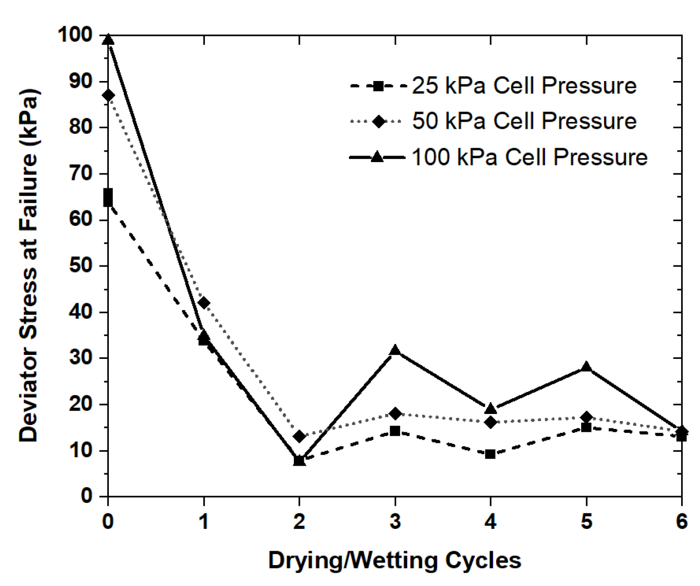
  • the poorly compacted panel had the greatest number of cracks with 11 of the 19 cracks present on the slope,
  • a linear cracking style was observed which contrasts with polygonal style generally seen in the laboratory (thought to be a result of root density),
  • wind data showed a sheltering of the northern slope while there was increased solar radiation exposure on the southern face, which resulted in increased vegetation diversity (hypothesized to result in preferential crack formation on the southern slope),
  • the upper section of the southern slope was subject to higher negative pore pressures during drying periods which was attributed to drainage under gravity, increased wind exposure, and surface runoff.
Measurement of the developing cracks on the embankment showed four stages of crack propagation: initiation of a crack, expansion of the crack to its maximum width and depth, minor contraction, and closure during winter. Similar patterns have also been observed in other poorly compacted manmade geostructures in heritage assets, such as Baile Hill mound (Figure 14).
These observations are also in agreement with laboratory data reported by Cheng, et al. [18], where the water content at which desiccation cracking was initiated was directly impacted by compaction conditions. These novel findings demonstrate the holistic nature of engineered soils and the link between the soil pore structure and its behaviour, which has significant implications for its future performance. Compacted soils that have a larger macro pore structure are likely to be more vulnerable to the onset of desiccation cracking. The predicted changes in rainfall and surface temperatures associated with climate change means these preferential pathways will allow water to enter slopes at greater rates and make them vulnerable to pore water pressure changes. This is particularly poignant for historic geostructures due to the reduced compactive effort during their construction.

10. Conclusions

Climate modelling using Representative Concentration Pathways (RCPs) show that the UK climate will experience increasingly high temperatures and widespread drought during summer, in conjunction with increasingly wetter winters due to growth in prolonged precipitation. This will have several negative impacts on vulnerable geostructures, making them increasingly prone to performance issues relating to their serviceability, and risk development of several failure mechanisms.
This vulnerability is linked to the pre-regulation techniques utilised on the railway network in the 19th and early 20th century, which typically included end-tipping (i.e., placement of non-engineered fill). In the latter half of the 20th and the 21st century, several pivotal regulations formalised construction techniques mainly implemented into the construction of major highways in the UK including the Preston By-Pass. However, these geostructures, constructed pre-regulation, remain part of the UK transport network.
Recent failures in the rail network (Stonehaven August 2020) have led to increased consideration for the effects of climate change and has spurred research into its impacts. Recent cutting-edge research has shown that hydraulic history of compacted soils is intrinsic to the performance of historic geostructures. The formation of micro cracks and variation in hydraulic hysteresis was observed to result in deterioration of compacted soil performance. Laboratory testing has also shown that poorly compacted soils may be more vulnerable to desiccation cracking due to their pore structure.
Existing research methodologies use several laboratory and field options for investigating soil atmosphere interaction, each with their own limitations. Ultimately, a combination of methods is required to produce results, which are both representative mechanically at micro scale and holistically at a field scale.

Author Contributions

The contribution from the different authors can be summarised as follows. Conceptualization, all authors; writing—original draft preparation, C.W.; writing—review and editing, all authors. All authors have read and agreed to the published version of the manuscript.

Funding

This research was funded by EPSRC, grant number EP/T517860/1.

Acknowledgments

The author gratefully acknowledges the support provided by the School of Civil Engineering, University of Leeds.

Conflicts of Interest

The authors declare no conflict of interest. The funders had no role in the writing of the manuscript.

References

  1. Skempton, A.W. Embankments and Cuttings on the Early Railways. Constr. Hist. 1996, 11, 33–49. [Google Scholar]
  2. Loveridge, F.; Spink, T.W.; O’Brien, A.S.; Briggs, K.M.; Butcher, D. The impact of climate and climate change on infrastructure slopes, with particular reference to southern England. Q. J. Eng. Geol. Hydrogeol. 2010, 43, 461–473. [Google Scholar] [CrossRef]
  3. O’Brien, A.S.; Ellis, E.A.; Russell, D. Old Railway Embankment Clay Fill—Laboratory Experiments, Numerical Modelling and Field Behaviour. In Advances in Geotechnical Engineering: The Skempton Conference; Thomas Telford Publishing: London, UK, 2004; pp. 911–921. [Google Scholar]
  4. Mcginnity, B.T.; Russell, D. Investigation of London Underground earth structures. In Advances in Site Investigation Practice; Thomas Telford Publishing: London, UK, 1995; pp. 230–242. [Google Scholar]
  5. Briggs, K.M.; Loveridge, F.A.; Glendinning, S. Failures in transport infrastructure embankments. Eng. Geol. 2017, 219, 107–117. [Google Scholar] [CrossRef] [Green Version]
  6. Noakes, P.; Mason-Jarvis, L.F.; Taylor, G.R.; Evans, E. Geospatial assessment methods for geotechnical asset management of legacy railway embankments. Q. J. Eng. Geol. Hydrogeol. 2020, 53, 339–348. [Google Scholar] [CrossRef]
  7. Tang, A.M.; Hughes, P.N.; Dijkstra, T.A.; Askarinejad, A.; Brenčič, M.; Cui, Y.J.; Diez, J.J.; Firgi, T.; Gajewska, B.; Gentile, F.; et al. Atmosphere–vegetation–soil interactions in a climate change context; impact of changing conditions on engineered transport infrastructure slopes in Europe. Q. J. Eng. Geol. Hydrogeol. 2018, 51, 156–168. [Google Scholar] [CrossRef]
  8. Lowe, J.; Bernie, D.; Bett, P.; Bricheno, L.; Brown, S.; Calvert, D.; Clark, R.; Eagle, K.; Edwards, T.; Fosser, G.; et al. UKCP 18 Science Overview Report November 2018 (Updated March 2019). Available online: https://www.metoffice.gov.uk/pub/data/weather/uk/ukcp18/science-reports/UKCP18-Overview-report.pdf (accessed on 11 May 2021).
  9. Network Rail. A Review of Earthworks Management. Available online: https://www.networkrail.co.uk/wp-content/uploads/2021/03/Network-Rail-Earthworks-Review-Final-Report.pdf (accessed on 20 August 2021).
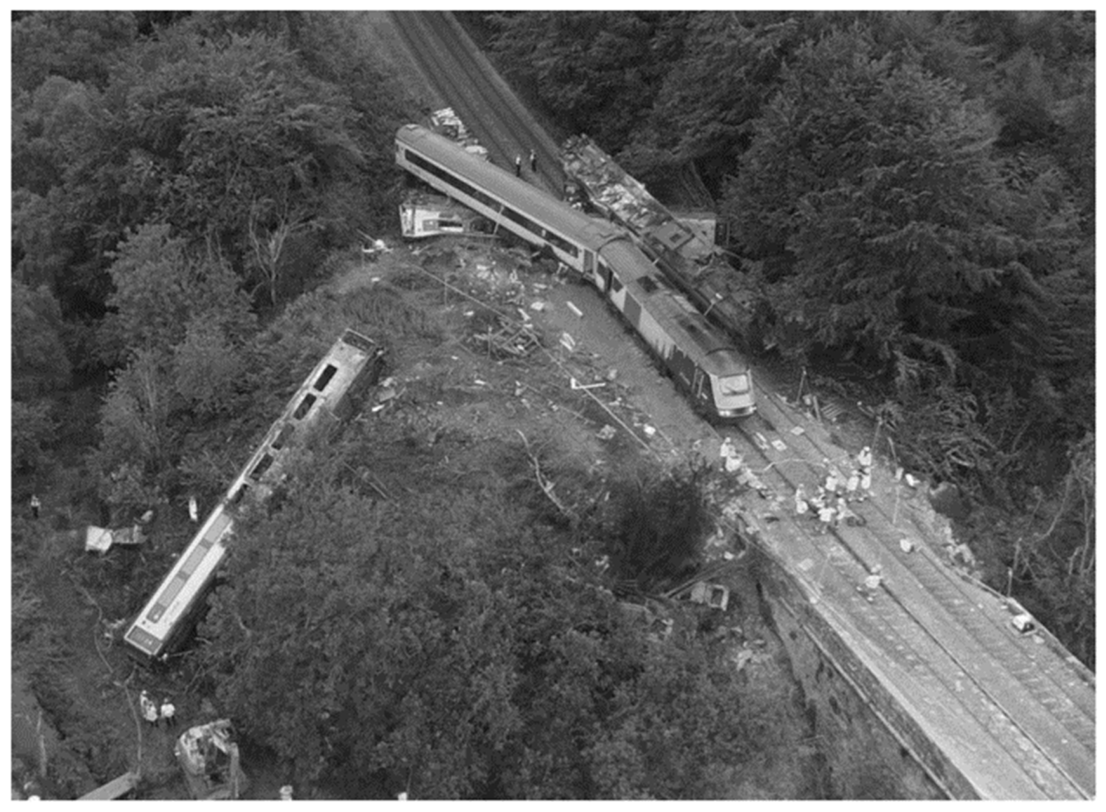
  10. RAIB. Rail Accident Investigation Interim Report Derailment of a Passenger Train at Carmont, Aberdeenshire 12 August 2020. Available online: https://assets.publishing.service.gov.uk/government/uploads/system/uploads/attachment_data/file/978828/IR012021_210419_Carmont.pdf (accessed on 19 August 2021).
  11. BBC News. Fatal train derailment ‘Like Hornby Set Thrown in Air’. Available online: https://www.bbc.co.uk/news/uk-scotland-north-east-orkney-shetland-54191006 (accessed on 15 September 2020).
  12. BBC News. Stonehaven Train Derailment: Crash Investigators Confirm Train Struck Landslip. Available online: https://www.bbc.co.uk/news/uk-scotland-north-east-orkney-shetland-53778891 (accessed on 15 September 2020).
  13. Nowak, P.; Gilbert, P. Earthworks: An historical perspective. In Earthworks: A guide; Thomas Telford Ltd.: London, UK, 2015; pp. 1–14. [Google Scholar]
  14. Nowak, P. Chapter 69 Earthworks design principles. In ICE Manual of Geotechnical Engineering: Volume II; Thomas Telford Ltd.: London, UK, 2012; pp. 1043–1046. [Google Scholar]
  15. Network Rail. Earthworks Technical Strategy. 2018. Available online: https://www.networkrail.co.uk/wp-content/uploads/2018/07/Earthworks-Technical-Strategy.pdf (accessed on 21 October 2020).
  16. Azizi, A.; Musso, G.; Jommi, C.; Cosentini, R. Evolving fabric and its impact on the shearing behaviour of a compacted clayey silt exposed to drying-wetting cycles. In Proceedings of the 7th International Conference on Unsaturated Soils (UNSAT2018), Hong Kong, China, 3–5 August 2018. [Google Scholar]
  17. Azizi, A.; Musso, G.; Jommi, C. Effects of repeated hydraulic loads on microstructure and hydraulic behaviour of a compacted clayey silt. Can. Geotech. J. 2019, 57, 100–114. [Google Scholar] [CrossRef]
  18. Cheng, Q.; Tang, C.; Zeng, H.; Zhu, C.; An, N.; Shi, B. Effects of microstructure on desiccation cracking of a compacted soil. Eng. Geol. 2020, 265, 105–418. [Google Scholar] [CrossRef]
  19. Stirling, R.A.; Toll, D.G.; Glendinning, S.; Helm, P.R.; Yildiz, A.; Hughes, P.N.; Asquith, J.D. Weather-driven deterioration processes affecting the performance of embankment slopes. Géotechnique 2020, 71, 957–969. [Google Scholar] [CrossRef]
  20. Wikimedia Commons. Wolverton Viaduct—Public Domain Image. Available online: https://commons.wikimedia.org/wiki/File:Wolverton_viaduct.jpg (accessed on 10 September 2021).
  21. Gellatley, M.J.; McGinnity, B.T.; Barker, D.H.; Rankin, W.J. Interaction of Vegetation with LUL Surface Railway Systems. In Vegetation and Slopes: Stabilisation, Protection and Ecology: Proceedings of the International Conference Held at the University Museum, Oxford, 29–30 September 1994; Thomas Telford Ltd.: London, UK, 1995; pp. 60–71. [Google Scholar]
  22. Proctor, R.R. Fundamental principles of soil compaction. Eng. News Rec. 1933, 111, 286–289. [Google Scholar]
  23. Atterberg, A. Die Plastizität der Tone (The plasticity of clays). Int. Mitt. Bodenkd. 1911, 1, 4–37. [Google Scholar]
  24. Terzaghi, K. Principles of final soil classification. Public Roads 1926, 8, 41–53. [Google Scholar]
  25. Casagrande, A. Research on the Atterberg Limits of Soil. Public Roads 1932, 13, 121–136. [Google Scholar]
  26. Kodikara, J.; Islam, T.; Sounthararaja, A. Review of soil compaction: History and recent developments. Transp. Geotech. 2018, 17, 24–34. [Google Scholar] [CrossRef]
  27. Perry, J.; Pedly, M.; Reid, M. Infrastructure Embankments C550; CIRIA: London, UK, 2003. [Google Scholar]
  28. Porter, O.J. The preparation of subgrades. Highway Res. Board Proc. 1939, 18, 324–331. [Google Scholar]
  29. Alawia, M.H.; Rajab, M.I. Prediction of California bearing ratio of subbase layer using multiple linear regression models. Road Mater. Pavement Des. 2013, 14, 211–219. [Google Scholar] [CrossRef]
  30. Nowak, P.; Gilbert, P. Earthworks: A Guide, 2nd ed.; ICE: London, UK, 2015; Available online: https://www.icevirtuallibrary.com/isbn/9780727741851 (accessed on 6 February 2020).
  31. Sargent, C. Britain’s Railway Vegetation; Institute of Terrestrial Ecology: Cambridge, UK, 1984. [Google Scholar]
  32. Highways England. Design Manual for Roads and Bridges (DMRB), Volume 10, Section 3, Part 2: Landscape Management Handbook; The Stationary Office: London, UK, 2004. [Google Scholar]
  33. Glendinning, S.; Loveridge, F.; Starr-Keddle, R.E.; Bransby, M.F.; Hughes, P.N. Role of vegetation in sustainability of infrastructure slopes. Proc. Inst. Civ. Eng.-Eng. Sustain. 2009, 162, 101–110. [Google Scholar] [CrossRef]
  34. Greenwood, J.R.; Norris, J.E.; Wint, J. Assessing the contribution of vegetation to slope stability. Proc. Inst. Civ. Eng.-Geotech. Eng. 2004, 157, 199–207. [Google Scholar] [CrossRef]
  35. Yeadon, H.L. Preston By-pass: The first motorway in the UK. Proc. Inst. Civ. Eng.-Eng. Hist. Heritage 2010, 163, 117–128. [Google Scholar] [CrossRef]
  36. Drake, J. Buliding The Motorway. Gaurdian, 5 December 1958; p. 16. Available online: https://www.newspapers.com/clip/90396771/preston-by-pass-construction/(accessed on 8 July 2022).
  37. Macmillan, H. Preston By-Pass Official Opening Booklet. Ministry of Transport and Civil Aviation Agent Authority. 1958. Available online: https://www.roads.org.uk/sites/default/files/articles/opening-booklets/prestonbypass.pdf (accessed on 8 July 2022).
  38. Sarsby, R.W. Compaction and earthworks. In Environmental Geotechnics; Thomas Telford Publishing: London, UK, 2013; pp. 59–76. [Google Scholar]
  39. Highways England. Climate Change Adaptation Strategy and Framework; England, H., Ed.; Home Office: London, UK, 2009. [Google Scholar]
  40. Network Rail. Claimte Change Adaptation Report; Network Rail Limited: London, UK, 2015. [Google Scholar]
  41. Varley, J. The Network Rail Vegetation Management Review; Home Office: London, UK, 2018. [Google Scholar]
  42. Network Rail. Vegetation Management. Available online: https://www.networkrail.co.uk/communities/environment/vegetation-management/ (accessed on 12 November 2020).
  43. O’Brien, A.S. The assessment of old railway embankments: Time for a change? Géotechnique 2013, 19–32. [Google Scholar] [CrossRef]
  44. Heitor, A.; Grady, M.; Russel, R.; Vongsvivut, J. Bio-mediated soil stabilisation using biopolymers for enhancing performance of transport infrastructure. In Eleventh International Conference on the Bearing Capacity of Roads, Railways and Airfields; CRC: Boca Raton, FL, USA, 2022; pp. 159–167. [Google Scholar]
  45. Briggs, K.M.; Smethurst, J.; Powrie, W.; O’Brien, A.S. Wet winter pore pressures in railway embankments. Proc. Inst. Civ. Eng.-Geotech. Eng. 2013, 166, 451–465. [Google Scholar] [CrossRef] [Green Version]
  46. Hughes, P.N.; Glendinning, S.; Mendes, J.; Parkin, G.; Toll, D.G.; Gallipoli, D.; Miller, P.E. Full-scale testing to assess climate effects on embankments. Proc. Inst. Civ. Eng.-Eng. Sustain. 2009, 162, 67–79. [Google Scholar] [CrossRef]
  47. Toll, D.; Lourenço, S.; Mendes, J.; Gallipoli, D.; Evans, F.; Augarde, C.; Cui, Y.; Tang, A.-M.; Rojas Vidovic, J.; Pagano, L.; et al. Soil suction monitoring for landslides and slopes. Q. J. Eng. Geol. Hydrogeol. 2011, 44, 23–33. [Google Scholar] [CrossRef]
  48. Ridley, A.; McGinnity, B.; Vaughan, P. Role of pore water pressures in embankment stability. Proc. Inst. Civ. Eng.-Geotech. Eng. 2004, 157, 193–198. [Google Scholar] [CrossRef]
  49. Kovacevic, N.; Potts, D.; Vaughan, P.R. Progressive failure in clay embankments due to seasonal climate changes. Proc. Int. Conf. Soil. Mech. Geotech. Eng. 2001, 3, 2127–2130. [Google Scholar]
  50. Nyambayo, V.P.; Potts, D.M.; Addenbrooke, T.I. The Influence Of Permeability On The Stability Of Embankments Experiencing Seasonal Cyclic Pore Water Pressure Changes. In Advances in Geotechnical Engineering: The Skempton Conference; Thomas Telford Ltd.: London, UK, 2004; pp. 898–910. [Google Scholar]
  51. Met Office. UKCP18 Guidance: Representative Concentration Pathways; Department for Environment Food & Rural Affairs: London, UK, 2018.
  52. van Vuuren, D.P.; Edmonds, J.; Kainuma, M.; Riahi, K.; Thomson, A.; Hibbard, K.; Hurtt, G.C.; Kram, T.; Krey, V.; Lamarque, J.-F.; et al. The representative concentration pathways: An overview. Clim. Change 2011, 109, 5. [Google Scholar] [CrossRef]
  53. IPCC Data Distribution Centre. Definition of Terms Used within the DDC Pages. 2019. Available online: https://www.ipcc-data.org/guidelines/pages/glossary/glossary_r.html (accessed on 20 October 2020).
  54. Hulme, M.; Dessai, S. Negotiating future climates for public policy: A critical assessment of the development of climate scenarios for the UK. Environ. Sci. Policy 2008, 11, 54–70. [Google Scholar] [CrossRef]
  55. Jenkins, G.; Murphy, J.; Sexton, D.; Lowe, J.; Jones, P.; Kilsby, C. UK Climate Projection Briefing Report. Available online: http://cedadocs.ceda.ac.uk/1321/ (accessed on 21 October 2021).
  56. Heitor, A.; Parkinson, J.; Kotzur, T. The Role of Soil Stabilisation in Mitigating the Impact of Climate Change in Transport Infrastructure with Reference to Wetting Processes. Appl. Sci. 2021, 11, 1080. [Google Scholar] [CrossRef]
  57. Clarke, D.; Smethurst, J.A. Effects of climate change on cycles of wetting and drying in engineered clay slopes in England. Q. J. Eng. Geol. Hydrogeol. 2010, 43, 473–486. [Google Scholar] [CrossRef]
  58. Kim, Y.; Kimball, J.S. Update to data originally published in: Kim, Y., J.S. Kimball, J. Glassy, and J. Du. 2017. An extended global Earth system data record on daily landscape freeze-thaw status determined from satellite passive microwave remote sensing. Earth Syst. Sci. Data 2020, 9, 133–147. [Google Scholar] [CrossRef] [Green Version]
  59. Caicedo, B. Physical modelling of freezing and thawing of unsaturated soils. Géotechnique 2017, 67, 106–126. [Google Scholar] [CrossRef]
  60. Ishikawa, T.; Tokoro, T.; Miura, S. Influence of freeze–thaw action on hydraulic behavior of unsaturated volcanic coarse-grained soils. Soils Found. 2016, 56, 790–804. [Google Scholar] [CrossRef]
  61. Zhu, F.; Heitor, A. Influence of Water Content on Track Degradation at Transition Zones. Transp. Infrastruct. Geotechnol. 2022, 9, 32–53. [Google Scholar] [CrossRef]
  62. Khalili, N.; Habte, M.A.; Zargarbashi, S. A fully coupled flow deformation model for cyclic analysis of unsaturated soils including hydraulic and mechanical hystereses. Comput. Geotech. 2008, 35, 872–889. [Google Scholar] [CrossRef]
  63. Gitirana, G., Jr. Weather Related Geo-Hazard Assessment Model for Railway Embankment Stability; University of Saskatchewan: Saskatoon, SK, Canada, 2005. [Google Scholar]
  64. Glendinning, S.; Hughes, P.; Helm, P.; Chambers, J.; Mendes, J.; Gunn, D.; Wilkinson, P.; Uhlemann, S. Construction, management and maintenance of embankments used for road and rail infrastructure: Implications of weather induced pore water pressures. Acta Geotech. 2014, 9, 799–816. [Google Scholar] [CrossRef]
  65. Toll, D.; Mendes, J.; Gallipoli, D.; Glendinning, S.; Hughes, P. Investigating the impacts of climate change on slopes: Field measurements. Geol. Soc. Lond. Eng. Geol. Spec. Publ. 2012, 26, 151–161. [Google Scholar] [CrossRef]
  66. Glendinning, S.; Helm, P.; Rouainia, M.; Stirling, R.; Asquith, J.; Hughes, P.; Toll, D.; Clarke, D.; Powrie, W.; Smethurst, H.; et al. Research-informed design, management and maintenance of infrastructure slopes: Development of a multi-scalar approach. IOP Conf. Ser. Earth Environ. Sci. 2015, 26, 207–215. [Google Scholar] [CrossRef]
  67. Mendes, J. Assessment of the Impact of Climate Change on an Instrumented Embankment: An Unsaturated Soil Mechanics Approach. Ph.D. Thesis, Durham University, Durham, UK, 2011. [Google Scholar]
  68. Take, W.A.; Bolton, M.D. Seasonal ratcheting and softening in clay slopes, leading to first-time failure. Géotechnique 2011, 61, 757–769. [Google Scholar] [CrossRef] [Green Version]
  69. Stirling, R.A.; Glendinning, S.; Davie, C.T. Modelling the deterioration of the near surface caused by drying induced cracking. Appl. Clay Sci. 2017, 146, 176–185. [Google Scholar] [CrossRef]
  70. Mendes, J.; Toll, D.G. Influence of Initial Water Content on the Mechanical Behavior of Unsaturated Sandy Clay Soil. Int. J. Geomech. 2016, 16, D4016005. [Google Scholar] [CrossRef] [Green Version]
  71. Briggs, K.M.; Dijkstra, T.A.; Glendinning, S. Evaluating the Deterioration of Geotechnical Infrastructure Assets Using Performance Curves. In Proceedings of the International Conference on Smart Infrastructure and Construction 2019 (ICSIC), Cambridge, UK, 8–10 July 2019; pp. 429–435. [Google Scholar]
  72. Pham, H.; Fredlund, D.; Barbour, S. A Study of hysteresis models for soil-water characteristic curves. Can. Geotech. J. 2005, 42, 1548–1568. [Google Scholar] [CrossRef]
  73. Gapak, Y.; Tadikonda, V.B. Hysteretic Water-Retention Behavior of Bentonites. J. Hazard. Toxic Radioact. Waste 2018, 22, 04018008. [Google Scholar] [CrossRef]
  74. Goh, S.G.; Rahardjo, H.; Leong, E.C. Shear Strength of Unsaturated Soils under Multiple Drying-Wetting Cycles. J. Geotech. Geoenvironmental Eng. 2014, 140, 6–13. [Google Scholar] [CrossRef]
  75. Heitor, A.; Indraratna, B.; Rujikiatkamjorn, C. The role of compaction energy on the small strain properties of a compacted silty sand subjected to drying–wetting cycles. Géotechnique 2015, 65, 717–727. [Google Scholar] [CrossRef] [Green Version]
  76. Ng, C.W.W.; Xu, J.; Yung, S. Effects of wetting-drying and stress ratio on anisotropic stiffness of an unsaturated soil at very small strains. Can. Geotech. J. 2009, 46, 1062–1076. [Google Scholar] [CrossRef]
  77. Ng, C.W.W.; Xu, J. Effects of current suction ratio and recent suction history on small-strain behaviour of an unsaturated soil. Can. Geotech. J. 2012, 49, 226–243. [Google Scholar] [CrossRef]
  78. Khosravi, A.; Shahbazan, P.; Pak, A. Impact of hydraulic hysteresis on the small strain shear modulus of unsaturated sand. Soils Found. 2018, 58, 344–354. [Google Scholar] [CrossRef]
  79. Khosravi, A.; McCartney, J.S. Impact of Hydraulic Hysteresis on the Small-Strain Shear Modulus of Low Plasticity Soils. J. Geotech. Geoenvironmental Eng. 2012, 138, 1326–1333. [Google Scholar] [CrossRef]
  80. Likos, W.J.; Lu, N. Hysteresis of Capillary Stress in Unsaturated Granular Soil. J. Eng. Mech. 2004, 130, 646–655. [Google Scholar] [CrossRef]
  81. Costa, S.; Kodikara, J.; Shannon, B. Salient factors controlling desiccation cracking of clay in laboratory experiments. Géotechnique 2013, 63, 18–29. [Google Scholar] [CrossRef]
  82. Tang, C.; Zhu, C.; Leng, T.; Shi, B.; Cheng, Q.; Zeng, H. Three-dimensional characterization of desiccation cracking behavior of compacted clayey soil using X-ray computed tomography. Eng. Geol. 2019, 255, 1–10. [Google Scholar] [CrossRef]
  83. Julina, M.; Thyagaraj, T. Quantification of desiccation cracks using X-ray tomography for tracing shrinkage path of compacted expansive soil. Acta Geotech. 2019, 14, 35–56. [Google Scholar] [CrossRef]
  84. Yu, Z.; Eminue, O.O.; Stirling, R.; Davie, C.; Glendinning, S. Desiccation cracking at field scale on a vegetated infrastructure embankment. Géotech. Lett. 2021, 11, 88–95. [Google Scholar] [CrossRef]
Figure 1. Painting by John Cooke Bourne (1837) showing a temporary wooden viaduct spanning a large failure alongside ongoing end-tipping works during the construction of the Wolverton embankment. Public domain image [20].
Applsci 12 07461 g001
Figure 2. Image showing end-tipping construction method, used during early construction of the British railway, at Blackbird Road, Leicester circa 1897 (Photo reproduced with permission of Record Office for Leicestershire, Leicester and Rutland).
Applsci 12 07461 g002
Figure 3. Profile of typical transport systems (Heitor, et al. [44], reproduced under the Creative commons Attribution license, CC BY-NC-ND 4.0).
Applsci 12 07461 g003
Figure 4. Pore water pressure profiles for London Underground Ltd. clay embankments (likely consisting of uncompacted London Clay fill) constructed in the late 19th century, measured by Ridley, et al. [48] in spring 2001 and organised by foundation material including: (a) stiff London Clay and (b) river terrace deposits and chalk (modified after Briggs, et al. [45]).
Applsci 12 07461 g004
Figure 5. Embankment cross section showing the development of progressive failure mechanism, where (a) is the early development of a rupture surface at the toe of the slope, followed by (b) just before failure (modified after Network Rail [9]).
Applsci 12 07461 g005
Figure 6. UK weather data (black lines) and UKCP18 (grey lines) forecasts (5th, 10th, 25th, 50th, 75th, 90th, and 95th percentiles are shaded) represented in terms of (a) mean temperature; (b) percentage summer precipitation change; and (c) percentage winter precipitation change, for both RCP 2.6 and 8.5 (contains public sector information licensed under the Open Government Licence v3.0, http://www.nationalarchives.gov.uk/doc/open-government-licence/version/3/, (accessed on 2 October 2021), © Crown copyright, Met Office, [8]).
Applsci 12 07461 g006
Figure 8. Aerial photograph of the Stonehaven train derailment on the 12th of August (Photo reproduced with permission of Rail Accident Investigation Branch, 2021).
Applsci 12 07461 g008
Figure 9. Unsaturated soil variables effect on transport infrastructure slope stability (modified after Gitirana [63]).
Applsci 12 07461 g009
Figure 10. Deterioration curves showing the change in performance of an embankment over time, where curve (a) represents a high plasticity highway embankment; (b) historic railway embankment with relict failure; (c) failure triggered by an excessively wet winter; (d) increase in seasonal extremes owing to climate change; and (e) maintenance to improve performance (modified after Briggs, et al. [71]).
Applsci 12 07461 g010
Figure 11. Relationship between deviator stress at failure and drying/wetting cycles (drying limit 15% water content and wetting to 22% water content) for a compacted sandy clay derived from the Durham Lower Boulder Clay, tested at different confining pressure levels (modified after Stirling, et al. [19]).
Applsci 12 07461 g011
Figure 12. ESEM micrographs of a compacted low-plasticity clayey silt, dried to a water content of 0.38% and wetted to the compacted water content (20%), where (a) shows clay peds (aggregates), clay particles C, silt particles S, and macropores; (b) clays ped (aggregate) and macropores; (c) mesopores; and (d) ped (aggregate) breakage after undergoing drying and wetting cycles (reproduced from Azizi, et al. [17], © Canadian Science Publishing or its licensors).
Applsci 12 07461 g012
Figure 13. Hysteretic soil water retention curve and associated commonly used definitions (modified after Pham, et al. [72]).
Applsci 12 07461 g013
Figure 14. Example of desiccation cracks observed in Baile Hill (York) heritage asset.
Applsci 12 07461 g014
Table 1. Comparison between both the pre-regulation and post-regulation construction techniques for embankments used during the founding of the UK railway and highway (motorway) network.
Construction/MaintenanceRailway OnlyRailway and Highway
Pre-Regulation—19th and Early 20th CenturyPost-Regulation—Mid 20th and 21st Century
Fill MaterialEmbankment fill sourced from adjacent cuttings with no quality control [1]Due to the new specifications, material was still sourced from cuttings, but now exceptions were made for material deemed ‘unsuitable’, e.g., import of fill material during the construction of the Preston By-Pass [35]
Compaction End-tipping was conducted with no compaction except at bridge abutments due to occurrence of differential settlement [14]Earthworks were constructed to an ‘end-product’ criterion by setting a required percentage density or method compaction [13]
Slope AngleEmbankments were formed at the angle of repose, due to end-tipping, and trimmed to 1:2 (vertical: horizontal), in some cases up to 1:1.5 and 16 m in height [5]Based off stability analysis and empirical observation of different geologies, e.g., infinite slope analysis, method of slices, and finite element calculated using Factor of Safety (FoS) for various construction stages
Foundations No consideration was made and topsoil was often left in place [5]Topsoil stripped and various ground improvement techniques used to provide adequate foundation conditions such as geotextiles, deep soil mixing, shallow stabilisation, vibro stone columns and drainage
Vegetation
Management
Line-side gangs managed growth of vegetation to minimise the occurrence of line-side fires due to steam locomotion [21]Mid-late 20th century, no management of vegetation was made on railway geostructures, however several vegetation standards now exist to manage risk and capitalise on its use for bioengineering [9]
InterventionsAsh packed under tracks to combat settlement and in situ burning of clay fills and the addition of ash took place to remediate landslips [9]Asset management procedures including various monitoring techniques such as piezometers, inclinometers, remote sensing, tiltmeters, and measurement of track geometry
Table 2. Failure mechanism for both embankments and cutting formed in soils in the UK (adapted from Network Rail [9]).
Failure Mechanisms Causes of Climate Vulnerability
Deep-seated Rotational Failure
  • Presence of relict failure surfaces due to poor historic construction practices
  • Over-steepened cut slopes in plastic clays (26 degrees rather than stable 14 degrees) and embankment slopes
  • Reactivation of low-strength residual shear surfaces due to increase in pore water pressure (inadequacy of historic drainage)
  • Increase in destabilising forces including loading of the head of a slope, train loading on embankments, or unloading of the toe of the slope due to erosion and shallow failures
  • Formation of progressive failure due to ratcheting of the slope surface resulting from shrink–swell of the weathered surface
Shallow Translational Failure
  • Formation of a weathered zone owing to seasonal shrink–swell and formation of micro-cracking and desiccation
  • Increase in permeability of the surficial weathered layer allowing penetration of water in the near surface, reducing negative pore pressures, resulting in downslope flow and formation of perched water tables
  • Intense summer rainfall and presence of desiccation cracks, possibly allowing for hydraulic forces to act between cracks and thus initiate a shallow slump
  • Presence of vegetation which increases seasonal shrink–swell cycles, aiding in the deterioration of the weathered front
  • Internal erosion and undercutting resulting from the increased permeability and outflow of water from the slope surface
Washout
  • Erosion resulting from over-ground flow during intense rainfall, usually resulting from the presence of insufficient drainage
Debris Flow
  • Movement of vegetation and soil resulting from intense rainfall and surface flows initiated from washouts or earth flows from a shallow failure
Table 3. RCPs and their resulting global mean surface temperature change from pre-industrial baseline by 2100 (adapted from Met Office [51] and van Vuuren, et al. [52]).
RCP (Wm2)Temp Change by 2081–2100 (°C)Assumptions
2.61.6Population—approx. 8.75 billion by 2100
Global GDP increase of $375 trillion by 2100
Primary energy consumption of 750 EJ by 2100
Use of bioenergy and carbon capture and storage resulting in negative emissions by 2100
4.52.8Population—approx. 9 billion by 2100
Global GDP increase of $300 trillion by 2100
Primary energy consumption of 900 EJ by 2100
Same energy mix as RCP 2.6 but a less extreme move to low-carbon technologies and larger energy demand
6.02.4Population—approx. 9.75 billion by 2100
Global GDP increase of $225 trillion by 2100
Primary energy consumption of 750 EJ by 2100
Same use of fossil fuels as RCP 8.5 but reduction in energy demand reduces release of emissions
8.54.3Population—12 billion by 2100
Low per capita income growth
Global GDP increase of $250 trillion by 2100
High primary energy consumption 1750 EJ by 2100
Increase in use of fossil fuels due to low technology development
Publisher’s Note: MDPI stays neutral with regard to jurisdictional claims in published maps and institutional affiliations.

