Article

Geoheritage in Deltaic Environments: Classification Notes, Case Example, and Geopark Implication

by
Anna V. Mikhailenko
1 and
Dmitry A. Ruban
2,*
1
Department of Physical Geography, Ecology, and Nature Protection, Institute of Earth Sciences, Southern Federal University, Zorge Street 40, 344090 Rostov-on-Don, Russia
2
Department of Economics and Management, Business School, Cherepovets State University, Sovetskiy Avenue 10, Cherepovets, 162600 Vologda Region, Russia
*
Author to whom correspondence should be addressed.
Environments 2019, 6(2), 18; https://doi.org/10.3390/environments6020018
Submission received: 15 January 2019 / Revised: 29 January 2019 / Accepted: 31 January 2019 / Published: 3 February 2019

Abstract

:
River deltas boast ecosystem richness, but their efficient conservation and management require consideration of the full spectrum of natural phenomena, including those which are geological. Few specialists have explored the issue of deltaic geological heritage (geoheritage), and the relevant knowledge remains scarce and non-systematised. This paper proposes the first classification of this geoheritage. Five categories are distinguished: entire-delta geological phenomenon, delta-associated “purely” geological features, delta-associated features resulting from geology–ecosystem interactions, geological features occasional to deltas, and geoarchaeological localities in deltas. Chosen as a case example, the Don River delta in the southwestern part of Russia possesses geoheritage of these categories, except for the latter. The relevant unique geological features differ by their types and ranks. Of particular interest is the phenomenon of a self-cleaning environment which prevents mercury concentration in the soil despite pollution from natural and anthropogenic sources. The complexity of the deltaic geoheritage, its co-existence with the rich biodiversity, and the aesthetical issues make geopark creation in river deltas a sensible venture. Relevant proposals have been made for Malaysia and the Netherlands–Belgium border, and the Don River delta in Russia also presents an appropriate location for geopark creation.

Graphical Abstract

1. Introduction

River deltas host specific and highly valuable environments distinguished by the transitional nature of complex river–sea interactions, rich biodiversity (especially in the case of deltaic wetlands), and significance for humans (high productivity of agriculture, transportation routes, and hydrocarbons) [1,2,3]. Effective conservation, rational management, and planning the sustainable development of these environments require consideration of the full spectrum of their unique features. The latter are not limited to only water objects and ecosystems, but also include geological peculiarities. All deltas are characterised by a specific geological and geomorphological setting and growth process.
Unique geological and geomorphological phenomena are termed generally as geological heritage (geoheritage sensu lato, i.e., including geomorphological heritage—see term definitions below). Since the end of the 20th century, its investigation has intensified significantly. The key ideas of geoheritage and its conservation (geoconservation) are conceptualised in the works of Brilha et al. [4], Gordon [5], Henriques et al. [6], Prosser [7], and Ruban et al. [8]. Importantly, the progress of geoheritage-related research has strengthened links between geoconservation and environmental management; the studies of geoheritage dynamics are linked to the understanding of environmental dynamics [9,10]. This research is often attached to particular geological domains or specific geological environments. Surprisingly, too little has been said about the geoheritage of river deltas, although this environment may provide a lot of precious geological information. Most likely, this lack of evidence can be explained by the low visibility of geological features on flat surfaces which are often covered by modern sediments, swamps, and dense vegetation. A few studies devoted to geoheritage in deltaic environments were undertaken by Badang et al. [11], De Waele et al. [12], Erskine [13], Kiernan [14], Semeniuk and Brocx [15], and Taha and El-Asmar [16]. The urgency of this precious but thematically and geographically dispersed information has become especially evident, marked by attempts to create delta-based geoparks on the border of the Netherlands and Belgium [17] and the realisation of delta-restricted environmental self-cleaning as a tourist attraction [18,19]. In both cases, the necessity for a general framework for evaluation of deltaic geoheritage is clear.
The main objective of this brief paper is to propose the first classification of geoheritage occurring in river deltas. This classification is tested with the example of the Don River delta in southwest Russia. The already available information on geoheritage in deltaic environments is also systematised and employed for the purposes of the present study.

2. Materials and Methods

The terminology employed in this paper partly follows the definitions proposed by Habibi et al. [20]. Geoheritage is the presence of ‘unique geological objects, geological processes, and pieces of geological environment that are important to modern society because of their scientific, educational, and touristic value’ [20], and geological heritage sites (geosites) are in-situ exposures of geoheritage [20] (see also definitions by Brocx and Semeniuk [21]). The compilation of literature data and field investigations permit finding potentially interesting geological features and judging their uniqueness. Geosites are physical geological objects, whereas geoheritage types are general characteristics that attribute unique features to the known geological phenomena (e.g., sedimentary, geochemical, geomorphological) [20]. The term ‘geoheritage category’ is used provisionally to make a distinction between informal groups of unique features for any particular purpose (e.g., for classifying geoheritage in deltaic environments).
Methodologically, the present study is two-fold. First, an attempt to classify deltaic geoheritage is made. This approach is fully conceptual, and it is derived from the very general understanding of the geological and geomorphological contexts of river delta development. The previous reports of the deltaic geoheritage from different regions of the world [11,12,13,14,15,16] were considered in order to find arguments for the accuracy of the proposed categories. In the other words, the first method was classification development. Second, the Don River delta in the southwestern part of Russia (Figure 1) was taken as a case example which facilitated testing the proposed classification. This second approach was based on three methods that are briefly explained below.
Numerous observations made by the authors over the course of their two decade-long investigations in this area permit them to undertake an inventory of the Don River delta geoheritage. First, the categories of deltaic geoheritage proposed in this paper were applied to this case example. It was then checked as to which of these categories are present in the Don River delta. Second, the established geological features were attributed to the standard geoheritage types. A total of 21 types can be distinguished, including stratigraphical, sedimentary, geochemical, and geomorphological (full classification is given in [20]; see also Brocx and Semeniuk [21]). Complex geosites comprising of several types are also possible. Third, the geoheritage categories were ranked by comparison with the other geosites known by the territories and consideration of their rarity. The rank may be local, regional, national, or global depending on the geosite uniqueness on the scale of area, province, country, or the world, respectively [20].

3. Results

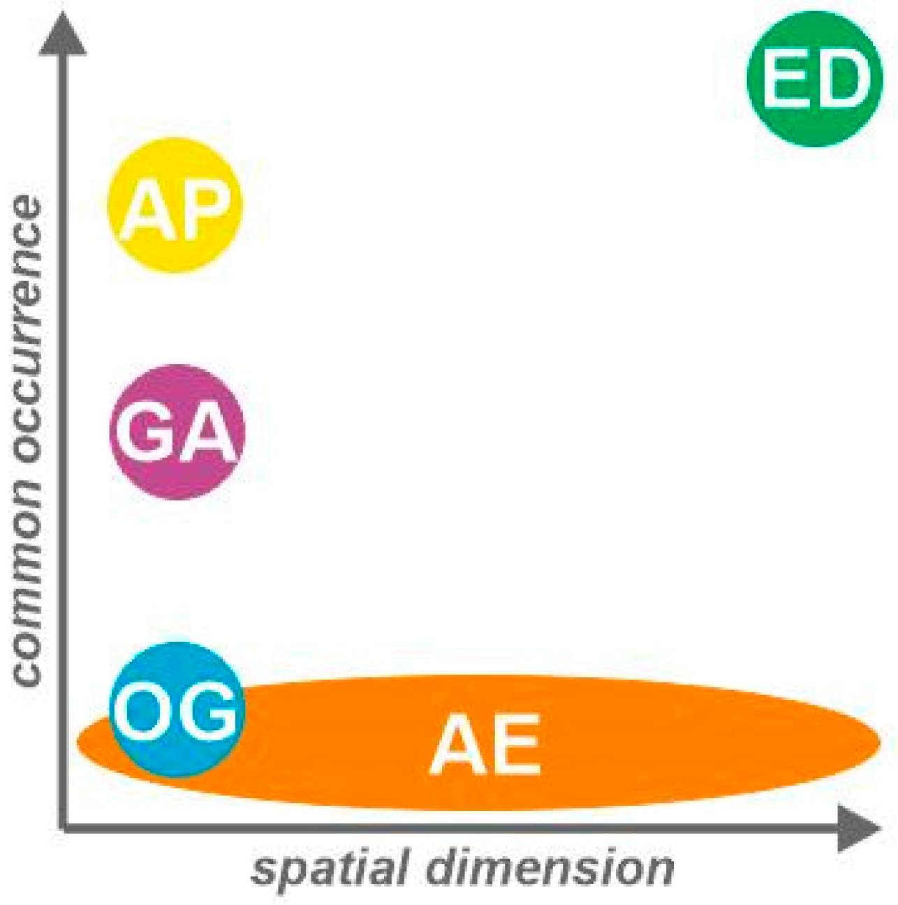
3.1. Proposed Classification
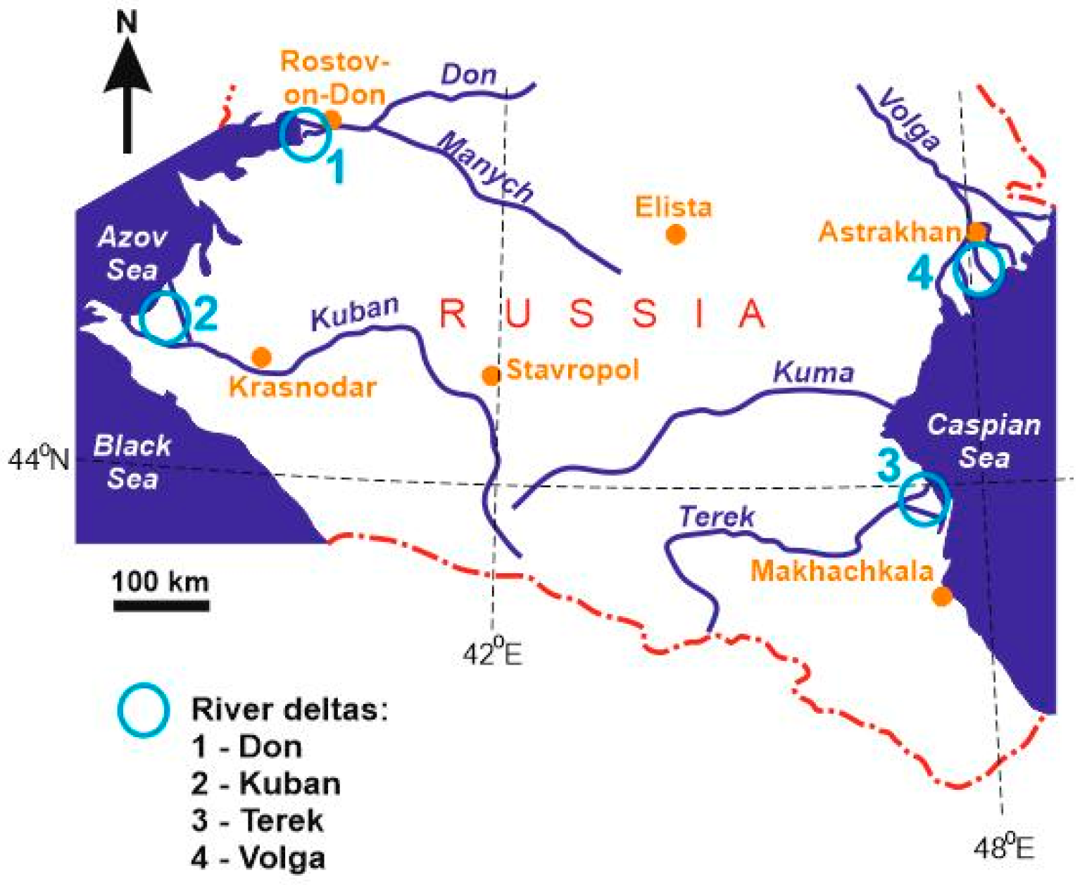
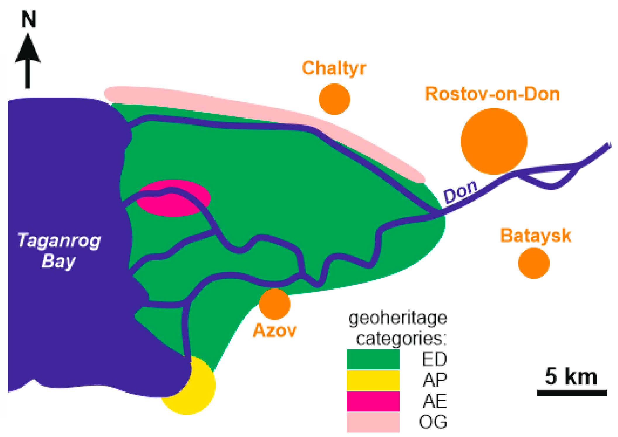
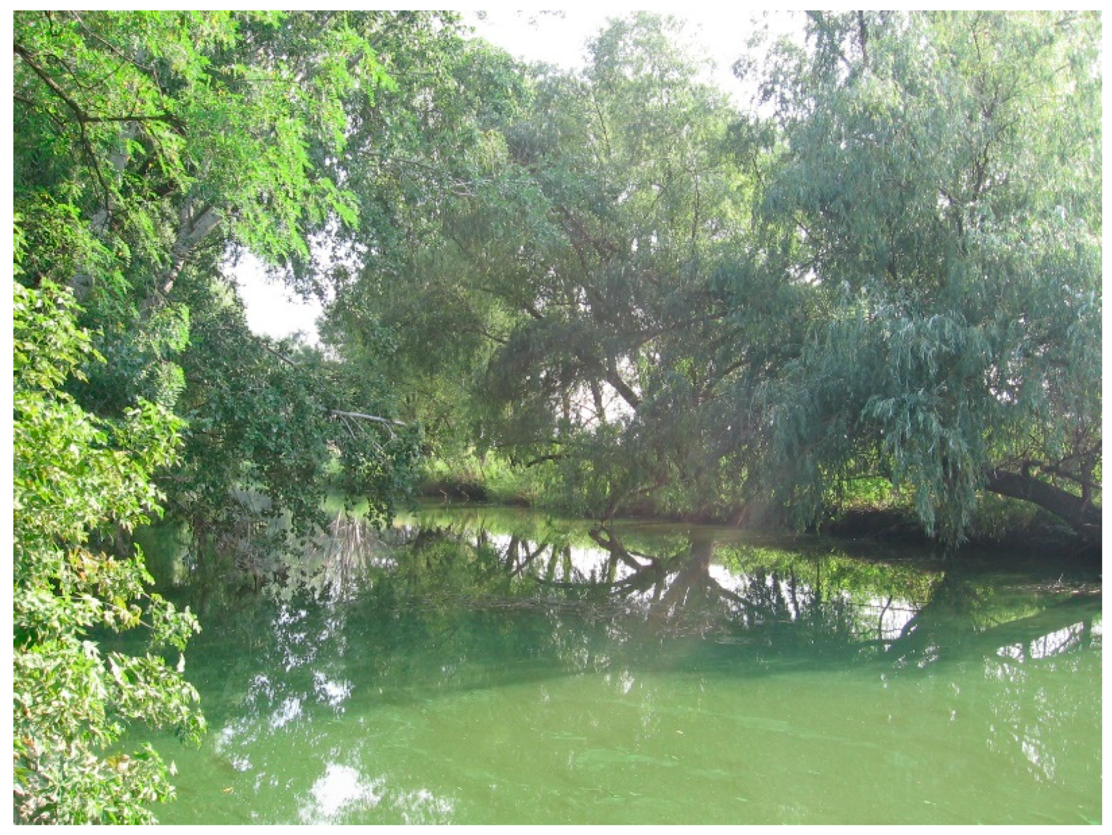
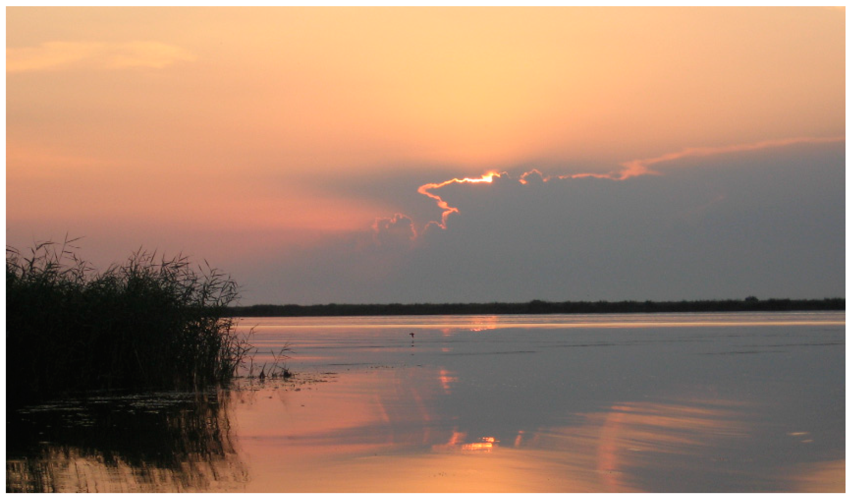
A total of five categories of geoheritage in deltaic environments are proposed. Despite its tentative character, such a classification appears to be rather comprehensive as it considers all principal modes of geological manifestations in river deltas.
The first category is entire-delta geological phenomenon (ED). In fact, river deltas are a particular class of geologically and geomorphogically determined objects because they reflect sediment delivery, mixing, differentiation, and partial accumulation at river mouths, i.e., the geological and geomorphological activity of rivers, as well as sea-level changes and tectonic processes [22,23,24]. These are highly specific, individually functioning geological and geomorphological systems. Therefore, it is sensible to believe that deltas, taken entirely, are large geoheritage objects. This principle was used for the recognition of the geoheritage value of the Sarawak River delta in Malaysia [11], the Oued Mellah delta in Tunisia [12], and the fluvial deltas of the Tuggerah Lakes in Australia [13]. It is notable that the deltas are small in size in these cases, which potentially facilitates their consideration as geoheritage.
The second category includes delta-associated “purely” geological features (AP). These may be exposures of deltaic deposits with characteristic layering, typical or unusual deltaic landforms, as well as cropped sedimentary successions and stratigraphic records which represent the long-term evolution of a given delta. In the other words, this category represents separate geological elements of deltas. An example is given in the work of Semeniuk and Brocx [15], who examined the geoheritage of the Fitzroy River in Australia. In particular, they noted sedimentary successions representing gulf–delta transition in the Quaternary period. These specialists also considered the entire delta as a globally unique geoheritage (ED category) because of the largest tidal range in the world. Additionally, some large, long-lived deltas boast significant hydrocarbon deposits. If the latter are unique, the relevant geological features and/or oil-/gas-production infrastructure objects should be attributed to the AP category.
The third category comprises delta-associated features resulting from geology–ecosystem interactions (AE). Such features are highly specific and potentially uncommon. These represent unique phenomena which are determined by both the geological setting/processes and environmental dynamics. Two examples are as follows. Mikhailenko et al. [19] described a case where the deltaic environment experienced significant mercury pollution from natural and anthropogenic sources, but periodical delta flooding facilitated the removal of mercury from soils, which looks like self-cleaning (this phenomenon is important, but restricted to soils, whereas bottom sediments and water remain polluted). This is a kind of unique geochemical phenomenon (attributed to geoheritage [20]), although it is strongly linked to environmental pollution and landscape functioning. The other example can be found in the work of Kiernan [14], who noted the creation of stone quarries and the significant anthropogenic modification of natural landforms in the Mekong delta. This implies the destruction of some natural geoheritage and creation of artificial geoheritage. The latter is strongly tied to the resource, i.e., the socio-economic importance of the deltaic environment. This category may also include unique geological and geomorphological features (such as landforms) which facilitate the growth of wetlands and perpetuate specific habitats, i.e., features that provide ecological support [25].
The fourth category embraces geological features occasional to deltas (OG). These features are “purely” geological, but do not necessarily occur in deltas. These may be outcrops of igneous rocks, pre-Quaternary sections, localities of fossils not linked to deltaic habitat, etc. Indeed, the very evolution of deltas leads to the erasure of pre-existing features and/or their covering by modern deposits. Moreover, wetland growth masks the exposures of such features. Considering these circumstances, objects of this category are expected to be rare, meaning no published examples can be provided (however, see the example below).
The fifth category is constituted from geoarchaeological localities in deltas (GA), including those which demonstrate humankind as a geological and geomorphological force. Rapid sediment accumulation in deltaic environments make the latter almost ideal for the preservation of important archaeological archives. Moreover, these are deltas where many ancient civilisations flourished. As a result, the geoarchaeological records of the deltas of the Nile [26], the Danube [27], and the Rhine [28] are world-unique. Bruno et al. [29] argued that unique geoarchaeological features should be attributed to the palaeogeographical type of geoheritage. If so, such features may constitute a significant aspect of deltaic geoheritage. A typical example can be found in the Manzala Lagoon in the Nile delta region of Egypt [16]. Generally, this category appeals to the cultural values of geoheritage [30,31].
Undoubtedly, geoheritage does not necessarily exist in all deltas because of the low uniqueness of geological features or poor exposure. However, the ED and AP categories seem to be common, and the GA category is also not as rare (Figure 2). In contrast, representatives of the AE and OG categories are supposed to be rare, and this rarity itself increases the uniqueness of the relevant features.

3.2. Case Example

The Don River delta is situated in the southwestern part of Russia (Rostov Region) where the Don River (length—1870 km) enters the Taganrog Bay of the Azov Sea (Figure 1). This is a relatively large delta with an area of >500 km2 (Figure 3) that possesses the classical deltaic environment with high-biodiversity wetlands (Figure 4). The area is crossed by numerous meandering channels, and it is flooded occasionally and for short periods of time (a few days) by wind-driven surges from the shallow-water Azov Sea [32,33]. The upper part of the delta enters the urban territory of Rostov-on-Don with a population of >1 million. The smaller town of Azov and several minor villages are located directly in the delta (Figure 3).
The inventory of the Don River delta geoheritage permits the establishment of the ED, AP, AD, and OG categories, according to the classification proposed above. Although important archaeological sites are known in close proximity to the study area [34], these are not linked directly to the delta. Further consideration of the archaeological context may result in the identification of representatives of the GA category.
The entire Don River delta is a kind of geoheritage (ED category) because the relevant geological and geomorphological processes (geological and geomorphological activity of running water, long-term creation of specific landforms, and voluminous sediment delivery) are unusual and, thus, unique. This large feature (Figure 3) can be attributed to the hydrological, geomorphological (Figure 5), and sedimentary types; however, its rank is no more than regional. Even in the territory of the Russian South, there are other large deltas belonging to the rivers of Kuban, Terek, and Volga (one of the most impressive deltas in Russia and the world) (Figure 1). The uniqueness of the Don River delta is limited to the Rostov Region.
An interesting feature is the formation of organic mud (provisionally termed as sapropel) that is particularly established in the southwestern corner of the delta (Figure 3). This phenomenon should be assigned to the AP category because the accumulation of this unusual sediment is related directly to the delta evolution, i.e., the presence of a flat alluvial plain with the massive delivery of fine siliciclastic and large amounts of organic matter linked to high ecosystem productivity. This feature should be attributed to the sedimentary type because it represents a particular type of soft sediment. Its rank is local-to-regional, as the uniqueness of such organic muds is restricted to the Rostov Region; there are several comparable sites in the territory of the latter.
The Don River delta experiences mercury pollution from both natural (outcrops of Carboniferous coals and Neogene black shales) and anthropogenic (coal combustion and agriculture) sources [18,35]. The results of modern investigations [18,36] imply that the content of mercury in soils on a test site in the western part of the delta (Figure 3) is comparable to the average content of this heavy metal in the soils throughout the world [37] and even lower than in some non-contaminated soils from the other regions [37]. This is explained in particular by the active mercury removal by precipitated water filtration through soft deltaic soils and, especially, the abovementioned surge-related occasional floods [18,36]. Such self-cleaning is very unique. As shown above, geoheritage of this kind belongs to the AE category as its type is geochemical. Two examples of self-cleaning deltaic environments have been described earlier [38,39]. As such, the discussed geoheritage feature is unique to the territory of Russia, i.e., it has a national rank.
Finally, some notable geological features can be found along the northern border of the Don River delta (Figure 3). These are natural exposures of the Neogene deposits, which exhibit sedimentary successions important for stratigraphic developments [40,41]. Fossils (chiefly bivalve molluscs) are abundant and taxonomically diverse in these rocks. The cliffs with these exposures are prone to landslides and thus provide representative examples of this phenomenon. These features are not associated with the delta itself but occur on its territory. These represent the OG category. These types are stratigraphic, paleontological, and engineered. The uniqueness is restricted to the western part of the Rostov Region because similar objects are found in its other parts too; therefore, the rank is local. However, the nearby vertebrate fossil localities are exceptionally important [42,43]. If similar localities exist in the delta itself, this geoheritage category should be ranked as regional or even national.
Generally, the case example of the Don River delta implies that significant and rather diverse geoheritage can be established in deltaic environments. In some cases, it is highly specific (especially in regard to the AE category). The proposed classification of this geoheritage can be applied well in the practice of geoheritage inventory. On the one hand, this helps to realise the true diversity of unique geological features and to relate their essence to the delta evolution. On the other hand, the knowledge of the spectrum of possible delta-related phenomena facilitates their identification.

4. Discussion

The proposed classification of geoheritage in deltaic environments implies that the categories of different features can differ spatially. Such multiscalarity of geoheritage was noted earlier by Serrano and Ruiz-Flaño [44]. While objects of the ED category are large in size and correspond to entire deltas, those of the AP, OG, and GA categories are small-sized localities dispersed within deltas (Figure 2). Objects of the AE category may be either as big as deltas if they represent large-scale phenomena, but they can also be restricted spatially to small localities where the phenomena appear to be mostly characteristic. Deltas can be understood as heterogeneous geoheritage complexes occupying large territories. For the purposes of efficient geoheritage management (inventory, conservation, promotion, and scientific, educational, and tourism use), it is sensible to identify them as large geosites or to create geoparks.
Badang et al. [11] and Kluiving et al. [17] have already proposed delta-focused geoparks in Malaysia and on the Netherlands–Belgium border, respectively. In the both cases, the central arguments for their creation were the uniqueness, richness, and integrity of the relevant geoheritage; however, some managerial considerations also matter. Geoparks offer permanent maintenance and well-developed infrastructure. They provide a better connection with nature conservation authorities, and contribute to the local sustainable development [45,46,47]. All these issues are very important for deltaic environments where geoheritage co-exists with rich ecosystems and various human activities in a relatively large territory. Several additional remarks on geopark suitability to deltas are possible. First, the proposed classification indicates heterogeneity of the deltaic heritage, the conservation and the exploitation of which requires the development of advanced strategies. Moreover, deltaic environments are highly dynamic and somewhat difficult to access (although boat tourism development may increase accessibility), which poses serious challenges for geoheritage management. Second, deltas often host unique ecosystems with significant biodiversity. If so, geoheritage management needs to be integrated into local nature conservation plans. Such integration aims to preserve the geological uniqueness that is usually less clear than the uniqueness of endangered species or wetland ecosystems. Nature conservation initiatives in deltas are often appropriately funded and supported by public and administrative authorities, which means additional opportunities for geoconservation. Geoparks, as official "enterprises", are ideal to connect the needs of geoconservation and nature conservation. Third, deltas sometimes (if not often) sustain local communities. If so, geoparks allow the easy integration of natural and cultural heritage. Fourth, in the case of hydrocarbon production in deltas, geoparks may be strong mediators in negotiations of energy resource companies and nature conservation activists.
In regard to the case example considered in this paper, it appears to be very sensible to pose the question of possible geopark creation in the Don River delta in addition to the existing Donskoy Natural Park. This geopark may attract scientists interested in studying the geological evolution of deltas, environmental geochemical processes, and the regional stratigraphy of the Russian South. Moreover, it may attract educators from local universities needing to explain delta geomorphology and geochemistry-related environmental functions and nature-focused tourists seeking to expand their experience. Its close location to educational institutes (several universities in Rostov-on-Don) and tourist destinations (Rostov-on-Don as a centre of business tourism, Azov as a centre of historical heritage tourism, and Starocherkassk as a centre of ethnic and cultural tourism) is a significant advantage for such a geopark, as well as a premise for the active involvement of the delta in regional-to-national nature conservation programs.
An additional but potentially important argument for the efficiency of geopark creation in deltas is linked to the visibility of geoheritage. The latter is often masked by vegetation or simply unclear to visitors with limited professional knowledge. Because of the deltas’ flatness (Figure 5), viewpoints for distance observation of geoheritage may not exist, although these are important for comprehending the geological uniqueness [48]. If so, the promotion of a given delta as a geosite may result in its poor visibility, incomplete understanding, and visitors’ dissatisfaction. In contrast, wetlands are often characterised by significant scenic value [49,50,51,52] determined by the dominance of water objects and dense vegetation in the perceived landscape image (Figure 4). Consequently, the full-scale integration of geo- and other natural heritage features [25] that is offered by geoparks recompenses the noted deficiency of visibility of its unique geological features. This is especially important in the case of geotourism activities.

5. Conclusions

From this first attempt at the conceptualisation of geoheritage in deltaic environments, three general conclusions were drawn. First, deltas may possess unique geological features, and their five general categories can be distinguished. Second, the case example of the Don River delta confirms that this geoheritage may be diverse. Third, the creation of delta-focused geoparks seems to be an efficient approach for the management of this kind of geoheritage. Future investigations should be aimed at geoheritage assessment in as many river deltas in the world as possible. Subsequent accumulation of information on this geoheritage may assist in identifying the relationship between its properties and some peculiarities of deltaic environments as determined by morphological types of deltas, climatic zones, and characteristics of anthropogenic pressure.

Author Contributions

Conceptualisation, D.A.R.; original data collection, A.V.M.; methodology, D.A.R.; investigation, A.V.M. and D.A.R.; writing, D.A.R.

Funding

This research was partly supported by the RF President grant MK6548.2018.5, agreement 075-02-2018-136 (contribution of A.V.M.). D.A.R. received no external funding.

Acknowledgments

The authors gratefully acknowledge the journal editorial team and anonymous reviewers for their helpful recommendations and support.

Conflicts of Interest

The authors declare no conflict of interest.

References

  1. Gayet, J. The delta environments: Morphology and sedimentation. Bulletin Institut de Geologie du Bassin d’Aquitaine 1989, 45, 45–61. [Google Scholar]
  2. Giosan, L.; Goodbred, S.L. Deltaic Environments. In Encyclopedia of Quaternary Science; Elsevier: New York, NY, USA, 2013; pp. 693–703. [Google Scholar]
  3. Arto, I.; García-Muros, X.; Cazcarro, I.; González, M.; Markandya, A.; Hazra, S. The socioeconomic future of deltas in a changing environment. Sci. Total Environ. 2019, 648, 1284–1296. [Google Scholar] [CrossRef] [PubMed]
  4. Brilha, J.; Gray, M.; Pereira, D.I.; Pereira, P. Geodiversity: An integrative review as a contribution to the sustainable development of the whole of nature. Environ. Sci. Policy 2018, 86, 19–28. [Google Scholar] [CrossRef]
  5. Gordon, J.E. Geoheritage, geotourism and the cultural landscape: Enhancing the visitor experience and promoting geoconservation. Geosciences 2018, 8, 136. [Google Scholar] [CrossRef]
  6. Henriques, M.H.; Pena dos Reis, R.; Brilha, J.; Mota, T. Geoconservation as an Emerging Geoscience. Geoheritage 2011, 3, 117–128. [Google Scholar] [CrossRef] [Green Version]
  7. Prosser, C.D. Our rich and varied geoconservation portfolio: The foundation for the future. Proc. Geol. Assoc. 2013, 124, 568–580. [Google Scholar] [CrossRef]
  8. Ruban, D.A.; Tiess, G.; Sallam, E.S.; Ponedelnik, A.A.; Yashalova, N.N. Combined mineral and geoheritage resources related to kaolin, phosphate, and cement production in Egypt: Conceptualization, assessment, and policy implications. Sustain. Environ. Res. 2018, 28, 454–461. [Google Scholar] [CrossRef]
  9. Bollati, I.; Pellegrini, M.; Reynard, E.; Pelfini, M. Water driven processes and landforms evolution rates in mountain geomorphosites: Examples from Swiss Alps. Catena 2017, 158, 321–339. [Google Scholar] [CrossRef]
  10. Pelfini, M.; Bolatti, I. Landforms and geomorphosites ongoing changes: Concepts and implications for geoheritage promotion. Quaest. Geogr. 2014, 33, 131–143. [Google Scholar] [CrossRef]
  11. Badang, D.; Ali, C.A.; Komoo, I.; Leman, M.S. Sustainable Geological Heritage Development Approach in Sarawak Delta, Sarawak, Malaysia. Geoheritage 2017, 9, 443–462. [Google Scholar] [CrossRef]
  12. De Waele, J.; Di Gregorio, F.; Gasmi, N.; Melis, M.T.; Talbi, M. Geomorphosites of Tozeur region (south-west Tunisia). Alp. Mediterr. Quat. 2005, 18, 223–232. [Google Scholar]
  13. Erskine, W.D. Flood-tidal and fluvial deltas of Tuggerah Lakes, Australia: Human impacts on geomorphology, sedimentology, hydrodynamics and seagrasses. IAHS-AISH Proc. Rep. 2013, 358, 159–167. [Google Scholar]
  14. Kiernan, K. Human Impacts on Geodiversity and Associated Natural Values of Bedrock Hills in the Mekong Delta. Geoheritage 2010, 2, 101–122. [Google Scholar] [CrossRef]
  15. Semeniuk, V.; Brocx, M. King sound and the tide-dominated delta of the Fitzroy river: Their geoheritage values. J. R. Soc. West. Aust. 2011, 94, 151–160. [Google Scholar]
  16. Taha, M.M.N.; El-Asmar, H.M. Geo-Archeoheritage Sites Are at Risk, the Manzala Lagoon, NE Nile Delta Coast, Egypt. Geoheritage 2019, 1–17. [Google Scholar] [CrossRef]
  17. Kluiving, S.; Kooistra, G.; Kasse, C.; Heskes, E.; Crombe, P.; Meersschaert, R.; Soens, T.; Kiden, P.; Vos, P.; Vandenberghe, N.; et al. Towards an international Geopark ‘Delta’ on the border of The Netherlands and Belgium. In Proceedings of the 19 EGU General Assembly 2017, Vienna, Austria, 23–28 April 2017; Volume 19, p. 19084. [Google Scholar]
  18. Mikhailenko, A.V.; Ruban, D.A. Geokhimitcheskij tip ob’ektov geologitcheskogo nasledija: Otlitchitel’nye tcherty, sozdanie poligonov i perspektivy turizma [Geochemical type of geological heritage sites: Peculiar features, test site establishment and tourism perspectives]. Geografitcheskij Vestnik 2017, 1, 11–17. (In Russian) [Google Scholar]
  19. Mikhailenko, A.V.; Ruban, D.A.; Yashalova, N.N. Ecosystem services of self-cleaning deltaic wetlands: Conceptual remarks. Espacios 2017, 38, 13. [Google Scholar]
  20. Habibi, T.; Ponedelnik, A.A.; Yashalova, N.N.; Ruban, D.A. Urban geoheritage complexity: Evidence of a unique natural resource from Shiraz city in Iran. Resour. Policy 2018, 59, 85–94. [Google Scholar] [CrossRef]
  21. Brocx, M.; Semeniuk, V. Geoheritage and geoconservation–history, definition, scope and scale. J. R. Soc. West. Aust. 2007, 90, 53–87. [Google Scholar]
  22. Syvitski, J.P.M.; Smith, J.N.; Calabrese, E.A.; Boudreau, B.P. Basin sedimentation and the growth of prograding deltas. J. Geophys. Res. 1988, 93, 6895–6908. [Google Scholar] [CrossRef]
  23. Voller, V.R. A model of sedimentary delta growth: A novel application of numerical heat transfer methods. Int. J. Numer. Methods Heat Fluid Flow 2010, 20, 570–586. [Google Scholar] [CrossRef]
  24. Wolinsky, M.A.; Edmonds, D.A.; Martin, J.; Paola, C. Delta allometry: Growth laws for river deltas. Geophys. Res. Lett. 2010, 37, L21403. [Google Scholar] [CrossRef]
  25. Bollati, I.; Crosa Lenz, B.; Golzio, A.; Masseroli, A. Tree rings as ecological indicator of geomorphic activity in geoheritage studies. Ecol. Indic. 2018, 93, 899–916. [Google Scholar] [CrossRef]
  26. Stanley, J.-D.; Toscano, M.A. Ancient archaeological sites buried and submerged along Egypt’s Nile Delta coast: Gauges of Holocene Delta margin subsidence. J. Coast. Res. 2009, 25, 158–170. [Google Scholar] [CrossRef]
  27. Romanescu, G. Tourist exploitation of archaeological sites in the Danube Delta Biosphere Reserve area (Romania). Int. J. Conserv. Sci. 2016, 7, 683–690. [Google Scholar]
  28. Waterbolk, H.T. Archaeology in the Netherlands: Delta archaeology. World Archaeol. 1981, 13, 240–254. [Google Scholar] [CrossRef]
  29. Bruno, D.E.; Crowley, B.E.; Gutak, J.M.; Moroni, A.; Nazarenko, O.V.; Oheim, K.B.; Ruban, D.A.; Tiess, G.; Zorina, S.O. Paleogeography as geological heritage: Developing geosite classification. Earth-Sci. Rev. 2014, 138, 300–312. [Google Scholar] [CrossRef]
  30. Reynard, E.; Brilha, J. (Eds.) Geoheritage: Assessment, Protection, and Management; Elsevier: Amsterdam, The Netherlands, 2018; pp. 1–482. [Google Scholar]
  31. Reynard, E.; Fontana, G.; Kozlik, L.; Scapozza, C. A method for assessing the scientific and additional values of geomorphosites. Geogr. Helv. 2007, 62, 148–158. [Google Scholar] [CrossRef]
  32. Fomin, V.V.; Alekseev, D.V.; Lemeshko, E.M.; Lazorenko, D.I. Simulation and Analysis of Sea Floods in the Don River Delta. Russ. Meteorol. Hydrol. 2018, 43, 95–102. [Google Scholar] [CrossRef]
  33. Matishov, G.G.; Chikin, A.L.; Berdnikov, S.V.; Sheverdyaev, I.V. The extreme flood in the Don River delta, march 23–24, 2013, and determining factors. Dokl. Earth Sci. 2014, 455, 360–363. [Google Scholar] [CrossRef]
  34. Schultze, E. The Don delta during the Roman period—State of research on the immediate surroundings of the antique city of Tanais. Eurasia Antiq. 2005, 11, 205–230. [Google Scholar]
  35. Dotsenko, I.; Fedorov, Y.; Mikhailenko, A. Mercury in the water of the Don River delta. In Proceedings of the International Multidisciplinary Scientific GeoConference Surveying Geology and Mining Ecology Management (SGEM), Albena, Bulgaria, 30 June–9 July 2018; Volume 18, pp. 509–516. [Google Scholar]
  36. Mikhailenko, A.V. Otsenka soderzhanija rtuti v potchvakh i donnykh otlozhenijakh del’ty reki Don [Mercury content measurement in soils and bottom sediments of the Don River delta]. Inzhenernyj Vestnik Dona 2015, 3, 170. (In Russian) [Google Scholar]
  37. Steinnes, E. Mercury. In Heavy Metals in Soils: Trace Metals and Metalloids in Soils and their Bioavailability; Springer: Dordrecht, The Netherlands, 2013; pp. 411–428. [Google Scholar]
  38. Malisauskas, A.P.; Sileika, A.S. Influence of flooding on accumulation of nutrients and heavy metals in the delta of the river Nemunas in Lithuania. Landbauforschung Volkenrode 2001, 51, 87–93. [Google Scholar]
  39. Vosniakos, F.; Petre, J.; Pascu, L.; Vasile, G.; Iancu, V.; Staniloae, D.; Nicolau, M.; Cruceru, L.; Golumbeanu, M. Aquatic ecosystem quality assessment of the Danube delta in the periods April-October 2007 and 2008. Fresenius Environ. Bull. 2010, 19, 20–29. [Google Scholar]
  40. Ruban, D.A. The Upper Miocene of the Rostov Dome (Eastern Paratethys): Implication of the chronostratigraphy and bivalvia-based biostratigraphy. Geološki Anali Balkanskoga Poluostrva 2005, 66, 9–15. [Google Scholar] [CrossRef]
  41. Ruban, D.A. Stratigraphic evidence of a Late Maeotian (Late Miocene) punctuated transgression in the Tanais Palaeobay (northern part of the Eastern Paratethys, South-West Russia). Geologos 2010, 16, 169–181. [Google Scholar] [CrossRef]
  42. Titov, V.V. Sus (Suidae, Mammalia) from the upper pliocene of the northeastern part of the Azov Region. Paléontol. J. 2000, 34, 203–210. [Google Scholar]
  43. Titov, V.V. Krupnye Mlekopitajutshie Pozdnego Pliotsena Severo-Vostotchnogo Priazov’ja [Large Mammals from the Late Pliocene of the North-Western Priazov’e]; SSC RAS: Rostov-on-Don, Russia, 2008; pp. 1–262. (In Russian) [Google Scholar]
  44. Serrano, E.; Ruiz-Flaño, P. Geodiversity: A theoretical and applied concept. Geogr. Helv. 2007, 62, 140–147. [Google Scholar] [CrossRef]
  45. Farsani, N.T.; Coelho, C.; Costa, C. Geotourism and geoparks as novel strategies for socio-economic development in rural areas. Int. J. Tour. Res. 2011, 13, 68–81. [Google Scholar] [CrossRef]
  46. Henriques, M.H.; Brilha, J. UNESCO Global Geoparks: A strategy towards global understanding and sustainability. Episodes 2017, 40, 349–355. [Google Scholar] [CrossRef]
  47. Justice, S.C. UNESCO global geoparks, geotourism and communication of the earth sciences: A case study in the Chablais UNESCO Global Geopark, France. Geosciences 2018, 8, 149. [Google Scholar] [CrossRef]
  48. Migoń, P.; Pijet-Migoń, E. Viewpoint geosites—Values, conservation and management issues. Proc. Geol. Assoc. 2017, 128, 511–522. [Google Scholar] [CrossRef]
  49. Lu, J.-S.; Liu, Y. Evaluation on exploitation potential of ecotourism resources of wetlands in Yellow River Delta. Wetl. Sci. 2010, 8, 339–346. [Google Scholar]
  50. Mamut, M.; Glamuzina, N.; Glamuzina, M. The tourist evaluation of the Neretva delta. Period. Biol. 2000, 102 (Suppl. 1), 475–482. [Google Scholar]
  51. Nnamdi, B.S.; Gomba, O.; Ugiomoh, F. Environmental challenges and eco-aesthetics in Nigeria’s Niger delta. Third Text 2013, 27, 65–75. [Google Scholar] [CrossRef]
  52. Wu, J.Y.; Xu, J.X. Visitor experience in the river corridor greenway: A study of Zengjiang River Greenway in Zengcheng, Guangzhou. Appl. Mech. Mater. 2013, 368–370, 474–477. [Google Scholar] [CrossRef]
Figure 1. Location of the deltas of the Don and the other large rivers of the Russian South; created by the authors.
Environments 06 00018 g001
Figure 2. Parameters of the deltaic geoheritage categories; abbreviations: AE—delta-associated features resulting from geology-ecosystem interactions, AP—delta-associated “purely” geological features, ED—entire-delta geological phenomenon, GA—geoarchaeological localities in deltas, OG—geological features occasional to deltas. Image created by the authors.
Environments 06 00018 g002
Figure 3. Location of the established geoheritage categories in the Don River delta. Image created by the authors.
Environments 06 00018 g003
Figure 4. A typical landscape of the Don River delta. Image credit: Anna V. Mikhailenko.
Environments 06 00018 g004
Figure 5. Panoramic view illustrating typical deltaic flatness of landforms. Image credit: Anna V. Mikhailenko.
Environments 06 00018 g005

