Article

Impact of Unregulated Parking Behaviors on Street and Sidewalk Infrastructure: Investigating Residential Districts with Apartment Zones in Jeddah, Saudi Arabia


Department of Landscape Architecture, Faculty of Architecture and Planning, King Abdulaziz University, Jeddah 21589, Saudi Arabia
*
Author to whom correspondence should be addressed.
Buildings 2026, 16(2), 272; https://doi.org/10.3390/buildings16020272
Submission received: 9 December 2025 / Revised: 31 December 2025 / Accepted: 6 January 2026 / Published: 8 January 2026
(This article belongs to the Section Architectural Design, Urban Science, and Real Estate)

Abstract

In the 21st century, Saudi cities have witnessed a high rate of private car ownership, averaging 1.38 vehicles per family. This has significantly increased demand for parking in residential areas, leading to unregulated parking behaviors that negatively affect street and sidewalk infrastructure. Although some research has been conducted in Saudi Arabia on illegal parking in commercial streets, research on unregulated parking in residential streets remains underexplored. This study investigates the impact of unregulated parking behavior on street and sidewalk infrastructure in residential districts with apartment zones in Jeddah, Saudi Arabia, determining the extent to which current sidewalk strips have been modified to extend on-street parking, create front setbacks for parking, and provide access to ground-floor private parking and residential building entrances. We selected six typical apartment building zones and mapped parking behavior through direct observations, processing collected data through ArcGIS. Our findings reveal negative impacts, resulting in significant parts of sidewalks, front setbacks, and streets being used for parking, thereby creating unhealthy and unsafe residential areas for walking and other physical activities. This study offers a comprehensive understanding of the unregulated parking problem and its subsequent impact on residents’ quality of life, particularly in terms of walking accessibility and safety.

1. Introduction

Residential sidewalks are essential components that enhance walkability for all community members. Highly accessible sidewalks are linked to higher physical activity levels and reduced obesity risk among children [1]. Furthermore, the condition of sidewalks is associated with physical activity, particularly for young residents [2]. Because pedestrians’ perception of safety and the physical layout of sidewalks are the primary factors impacting their use [3], improving residential sidewalks can create safe environments for older adult walkers, prevent falls [4] and promote walkability and active living for all [5].
Rapid economic and urban development has made the Kingdom of Saudi Arabia one of the largest car importers in the Gulf region, with over 12 million vehicles in 2019, a number that is expected to reach 25 million by 2030 [6]. Saudi Arabia has a high rate of private car ownership, with an estimated average of 1.38 vehicles per family [7]. Its growing population and high private vehicle ownership rate have increased the demand for parking in Saudi cities, causing considerable problems of illegal and informal parking in residential areas with apartment buildings, which has been widely discussed in Saudi media [8,9,10].
The increase in private vehicle ownership in residential districts with apartment zones, combined with inappropriate parking standards and impractical building regulations, has resulted in the deteriorating quality of residential public spaces in Saudi cities. For example, parking on sidewalks causes damage, and continuous parking on street lanes to the point of blocking traffic has become widespread [11]. Sidewalks are used for parking even in residential areas with recently improved public realm projects and allocated parking areas [12]. Previous studies on residential public realms in Saudi cities indicate that sidewalks were blocked by illegally parked vehicles, elements of street furniture such as street signals, and trees [13,14]. This contrasts with the view that highlights the availability of accessible and appropriate sidewalks [3], including perceptual qualities of traffic, aesthetics, and safety in residential areas as important aspects that promote walking [15].
Saudi Arabia developed its Vision 2030 framework to make its cities more livable [16]. It established the Quality-of-Life Program (QLP) [17] to achieve this goal. One of the QLP’s strategic goals is the Improvement of the Urban Landscape in Saudi cities, which also includes the Cities Humanization initiative, aiming to have three Saudi cities within the top 100 most livable cities in the world [17]. This goal includes providing an integrated and attractive urban environment by improving walking infrastructure, increasing the provision of green spaces, and providing essential services in public spaces to enhance residents’ quality of life.
One of the three cities targeted for inclusion among the top 100 most livable cities is Jeddah, the second largest city in Saudi Arabia, with an estimated population of 5 million. However, it is currently a car-dominated city with almost 96% of its residents relying on private vehicles for their trips [18] because of the lack of a proper public mass transportation system [19]. Additionally, its population density reaches up to 427 people per hectare in apartment building zones according to the Jeddah City Profile [18]. Consequently, considerable parking issues have emerged in Jeddah’s residential districts with apartment zones owing to the lack of a regulated on-street parking system and impractical building regulations, which significantly impact livability [20,21]. Therefore, addressing unregulated parking—which contributes to the degradation of walkability infrastructure (sidewalks and streets)—is the primary motivation of this study. This issue poses a barrier to achieving the Improvement of the Urban Landscape strategic goal and the Cities Humanization initiative of Saudi Vision 2030, and it directly affects residents’ quality of life.
This study investigates unregulated parking behaviors and their impact on current street and sidewalk infrastructure in Jeddah’s residential districts with apartment zones. It also investigates the extent to which sidewalk strips have been modified to extend on-street parking or access to front setback or ground-floor private parking. The term unregulated is defined as an activity or business that is not controlled or directed by fixed laws or rules [22]. Thus, for this study, we defined unregulated parking as parking in areas along residential streets without established regulations. In these areas, violations do not result in fines, towing, or other penalties. Examples include parallel parking on wide residential streets, parking on sidewalks or pedestrian paths, in public residential open spaces, in front of driveways, or in vacant lots.
The significance of this study lies in its ability to provide a clear measurement of the problem and its impact on residents’ quality of life, specifically in terms of walking accessibility, safety from traffic, and the overall visual quality of residential streets. By addressing the issue of high demand for parking and the modifications to sidewalks to serve such a demand in residential districts with apartment zones, this study contributes to the ongoing efforts of the QLP, aligning with its goals of improving urban environments and enhancing the livability of cities. The findings of this study will provide valuable insights for policymakers, urban planners, and other relevant stakeholders in developing effective strategies to mitigate the challenges associated with on-street parking in residential areas, thereby realizing their ultimate aim of creating more walkable and sustainable residential environments that prioritize the well-being and quality of life of Saudi Arabian residents.

2. Jeddah’s Local Plan 1440 and Apartment Building Parking Requirements

According to Jeddah’s most recent Local Plan 1440 [23], new apartment buildings are limited to four floors plus a parking floor and a roof extension (two villa units). The Local Plan mandates private parking within the boundary of the premises. Its building regulations demand more parking by either providing one parking space for every 150 m square of the residential plot’s total land area or for each apartment unit that will be built. However, the first villa unit in the roof extension is exempted. Moreover, the Local Plan only allows the construction of one parking floor in apartment buildings with four floors or less, and the parking floor height—2.2 to 2.5 m—is not counted in the total building height. The Local Plan also allows 10% of the total land area of the parking floor, without interfering with the required amount of parking spaces to be provided, to be used to accommodate private drivers who work for families living in these buildings.
Existing residential buildings may also benefit from the Local Plan if they adhere to its technical requirements and obtain an official building extension license. To qualify, owners must provide the required parking spaces either on the entire ground floor or outside the premises. The extension license is granted only after the parking has been constructed and a certificate from an accredited design consultancy is submitted, confirming that the required number of parking spaces and specifications—including any necessary façade redesigns—have been met [23]. Additionally, the Local Plan 1440 encourages developers to increase residential parking by allowing an increase in the floor area and its ratio equivalent to the land area dedicated to additional parking spaces, beyond the required minimum. However, this additional parking allocation must not be repurposed or sold for other uses [23].
With respect to apartment building setbacks, the Local Plan 1440 mandates that building lines along streets must be respected and that front setbacks—despite being considered private spaces—must remain free from construction. In apartment building zones, front setbacks must be at least four meters wide and, if the building faces more than one street, other setbacks must be at least three meters wide. These setback requirements also apply to ground-floor parking [23]. Additionally, the intersection between the driveway and the ground-floor garage entry must feature a clearly marked crossing, with a minimum width of 3.5 m and a clearance height of at least 2.5 m to ensure that drivers have a clear line of sight when exiting the parking garage and that pedestrians using sidewalks can cross safely [24].

3. Literature Review

3.1. Impact of Illegal, Informal, and Unregulated Parking on Urban Streets

Cities that experience a shortage of available parking spaces usually give rise to illegal, informal, or unregulated parking activities. Illegal parking refers to vehicles being parked in areas that are prohibited by law, identified by clearly posted signs [25]. Parking violations comprise placing vehicles in no-parking zones, blocking fire hydrants or driveways, and taking up disabled parking spaces without authorization. Informal parking occurs in unofficially designated areas not intended for parking, such as street sides and empty lots [26]. However, unregulated parking refers to parking in areas that do not have any established regulations. Typically, the appearance of one or more of these three parking behaviors creates major urban problems as recorded in several international cities such as Washington D.C. [27], London [28], Amsterdam [29], and Greece [30].
Several reasons compel drivers to resort to illegal, informal, or unregulated parking, including systemic issues and personal conduct. The belief that penalties for breaking parking rules remain minimal compared to major traffic offenses such as speeding and running red lights is a significant factor [31,32]. This perception exists because of the high rate of car ownership combined with insufficient parking spaces, making driving challenging [25,33]. The insufficient development of public transport networks can worsen this situation because most people depend on personal vehicles for their daily travel needs.
The combination of vehicle-centered planning and limited parking availability drives individuals toward illegal, informal, and unregulated parking activities. The decision to park illegally or in unregulated areas stems from drivers’ need to avoid parking fees in areas with weak or irregular law enforcement [25,34]. Such tendencies stem from unrefined driver behavior, which produces improper parking choices. Practical considerations, including walking distance to the destination and the nature of the trip, can also determine how people choose their parking spaces [34].
Illegal, informal, and unregulated parking behaviors negatively impact urban areas, leading to major disruptions of pedestrian movement and traffic flow. Previous studies have demonstrated that vehicles that block sidewalks and crosswalks make these areas impractical for pedestrian use [35,36]. This obstruction often forces pedestrians to walk in the street and navigate around parked vehicles, creating unsafe conditions. Disrupted pedestrian movements and accessibility can result in severe outcomes, including traffic congestion, accidents, and delays [35,36,37]. When public areas transform into parking spaces, air pollution increases, and the neighborhood’s aesthetic and recreational worth decreases, lowering the overall quality of these places [36,38].
The negative effects of illegal, informal, and unregulated parking have led to the introduction of multiple initiatives and policies that push for safe, well-designed urban spaces that serve all users. Jacobs [39] and Gehl [40] have advocated for “Pedestrian Oriented Cities”, which promote pedestrian-centered planning and design in urban development. This approach targets pedestrian experience enhancement by respecting their desired routes while creating more walking paths to support walkability [41]. A comprehensive public transport system, along with sustainable transportation promotion, is in high demand. A strategy to decrease free parking spaces should be implemented to promote walkability, while simultaneously encouraging public transportation use [42,43].

3.2. Previous Studies Investigating Residential Street Parking

Illegal, informal, and unregulated parking is a critical issue in traffic management and planning. The majority of previous studies on parking issues have examined parking management [44], policies [45], fees [46], and behavior [47]. However, research on the impacts of informal and unregulated parking in residential streets is scarce.
The conflict between vehicles and pedestrians on residential sidewalks has become a crucial area of study, especially in urban areas where informal and unregulated parking practices pose a challenge to public spaces. Popescu [33] examines this situation in Bucharest, Romania, showing how sidewalks are often used as extensions of private property for parking. This study uses ethnographic research to reveal how car ownership has become the norm, blocking pedestrian paths and creating an unfriendly environment for non-drivers. These findings reveal a cultural shift allowing the use of sidewalks for parking, thus reducing the usability of these public spaces.
Ünsal [48] extends this discussion to Ankara, Turkey, where illegal and unregulated parking causes problems on urban roads. This study used video recording, Global Positioning System tracking, and a Geographic Information System (GIS) to show that unregulated parking—including double parking and parking near intersections—reduces the flow of traffic and causes severe congestion during peak hours. Unregulated parking also reduces road width to almost one lane, which hampers urban mobility.
Kirschner [49] investigates the outcomes of on-street parking on residents’ perceived conflicts through a comprehensive household survey of 1027 residents in Frankfurt, Germany. The household survey revealed that parked vehicles frequently impede walking and cycling, creating safety challenges. The researcher recommends a separate infrastructure for pedestrians and cyclists to enhance urban mobility and improve residents’ safety.
Similarly, Schlossberg and Amos [50] assess on-street parking in residential neighborhoods in Eugene, Oregon, in the United States. A walking audit was employed to survey 143 blocks between 5 p.m. and 7 p.m. on weekday evenings to gather data on the number of on-street parking spaces, driveway lanes, vehicles parked on the street, vehicles parked in driveways, and any parking restrictions. The results revealed that approximately 87% of on-street parking spaces were vacant, reflecting wasted public resources. Their research recommends revising street design standards to eliminate redundant parking lanes and utilize them for alternative purposes, such as green infrastructure and community amenities that improve the neighborhood’s livability.
In New York, Guo [51] assesses the effect of on-street parking supply on private car ownership among households with off-street parking. The study used Google Street View and Bing Maps to determine the availability of off- and on-street parking for every household. The results reveal that free residential street parking increases private car ownership by approximately 9%, demonstrating the effects of parking policies on urban transportation systems.
In Saudi Arabia, a few academic studies have been conducted on such a topic. For example, Al-Fouzan [52] reviews and compares car parking standards in the United Kingdom, United States, and Saudi Arabia to draw lessons for improving parking policies in Saudi Arabia. The study used a comparative analysis of parking standards obtained from official guidelines and previous studies to determine how these policies affect transportation and land use. Findings indicate that Saudi Arabia’s parking policies are based on minimum parking standards, which are not consistent with city zoning or land use. In contrast, both the United Kingdom and the United States have shifted their polices from mandating minimum parking requirements to establishing maximum parking limits. The study concludes that Saudi Arabia needs to change its parking policies to not only improve urban livability and transport accessibility but also reduce traffic congestion and air pollution.
Aljoufie [53] analyzes illegal parking activities in Jeddah by surveying five sites during morning, afternoon, and evening peak hours. The findings reveal that illegal parking occurs frequently, especially during weekend evening peak hours. The excessive parking requirements cause drivers to park illegally in informal spots even when official parking areas are accessible nearby. The researcher advocates for enhanced parking management strategies to decrease illegal parking occurrences.
The growing number of studies on illegal, informal, and unregulated parking behaviors highlights important knowledge gaps regarding their effects on urban environments. Most of the research on this topic has occurred in Western countries, overlooking the unique challenges faced in developing countries, particularly in the Middle East. Moreover, although prior research conducted in Saudi Arabia compared international standards and explored illegal parking issues on commercial streets, it did not investigate unregulated residential parking and its impact on sidewalk and street infrastructure. In addition, the research methods used in previous studies depended on literature review and survey data, failing to effectively capture the real effects of unregulated parking behaviors on urban environments. Thus, our study emphasizes the necessity of empirical research based on direct observations to map and investigate residential unregulated parking behaviors and consequences.

4. Methods

4.1. Study Area

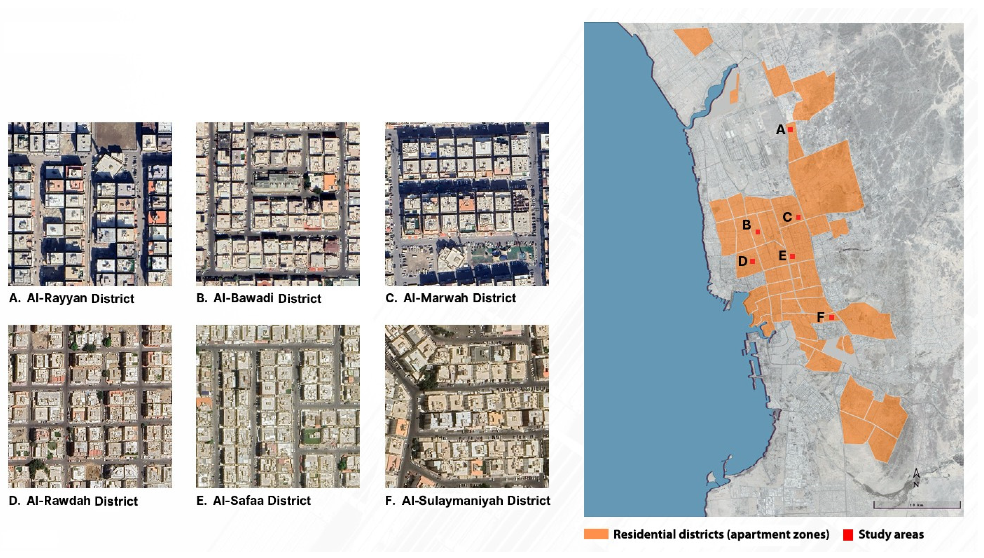
For this study, six representative residential districts containing apartment zones were chosen from across Jeddah. These districts reflect the majority of Jeddah’s urban fabric, as they were built using a modern grid and developed at different time periods. However, because of their vast land area and the limited resources to conduct a large-scale mapping, an approximate area of five hectares was selected for investigation from each residential district. We ensured that the physical components that constituted each five-hectare area represented the entire character of the residential district. The distribution of the residential districts is presented in Figure 1, while the information about each one is presented in Table 1.

4.2. Methodology

Previous studies on mapping parked vehicles in urban areas employed different methods. Although one such method included remote sensing and satellite images [54], it had its limitations. Zambonini et al. [54] highlighted that mapping parked vehicles through satellite images, along residential streets with high buildings, trees, and other artificial objects on the ground-floor level, cannot be accurate as the satellite position along its orbit has different in-track and cross-track viewing angles. However, direct observations ensure more accurate and updated data collection. Deming and Swaffield [55] confirmed that using direct observations to map objects can produce useful data if performed systematically. For example, a direct observation strategy was used to map obstructive parking on sidewalks and pedestrian crossings surrounding 77 New York Department station houses [56].
In this study, we employed the direct observation strategy, combined with ArcGIS Pro 3.6, to map parking behaviors and their impact on sidewalks and street infrastructure. We aimed to collect detailed conditions that cannot be captured by analyzing satellite images alone, such as identifying where private vehicles were parked–whether completely on the side of the street or partially on sidewalks, buildings’ front setbacks, under dense trees, shade structures, or alongside high buildings—all of which were highlighted as limitations based on the analysis of satellite images. Such a combined research strategy was successfully used to map physical elements of the built environment that block visual and public walking access [57].

4.3. Mapping Parking Behaviors on Street Lane and Sidewalk Infrastructure

We manually mapped all forms of parking behaviors—including parking on street lanes, existing sidewalks or their zones (after removal), and vacant blocks—on printed maps of the selected five hectares in each of the six residential districts using Google Maps. To ensure precise and systematic mapping, we recorded coordinates for the vehicles using a mobile data collection application, and then we exported the data into the GIS. We also used two car sizes—large (10 m2) and small (8 m2)—to ensure systematic mapping. We mapped parking behaviors across two time periods—12:00 noon and 12:00 midnight—on 11 and 12 September 2023, which were weekdays. We assigned two observers to each study area. Observers began from a designated starting point and systematically recorded vehicle behaviors as they moved along both sides of the streets. The procedure involved mapping all parked vehicles. The entire mapping process took approximately one hour at each location. We selected the 12:00 noon period to investigate the street and sidewalk land areas that were free after residents with different start-time jobs left for work. We selected the 12:00 midnight period to explore the total land area of each residential district occupied by parking, allowing us to record the maximum parking capacity when nearly all residents were home, as most attractions, businesses, and public venues were closed. We selected our sample during weekdays because most residents leave for work during the day or at noon, depending on their job, and are home at night. On weekends, residents may stay home during the day for various reasons (e.g., relaxing), be away at night (e.g., traveling), or return home late from social activities.
Next, after completing the mapping, we used ArcGIS to process the collected data for the six residential districts and calculate the land area of streets and sidewalks occupied by parking during the two selected time periods. We excluded the parts of parked vehicles on vacant blocks and front setbacks from the calculation, as these areas were officially considered private spaces [23].

4.4. Mapping Major Encroachments to Sidewalk Zones

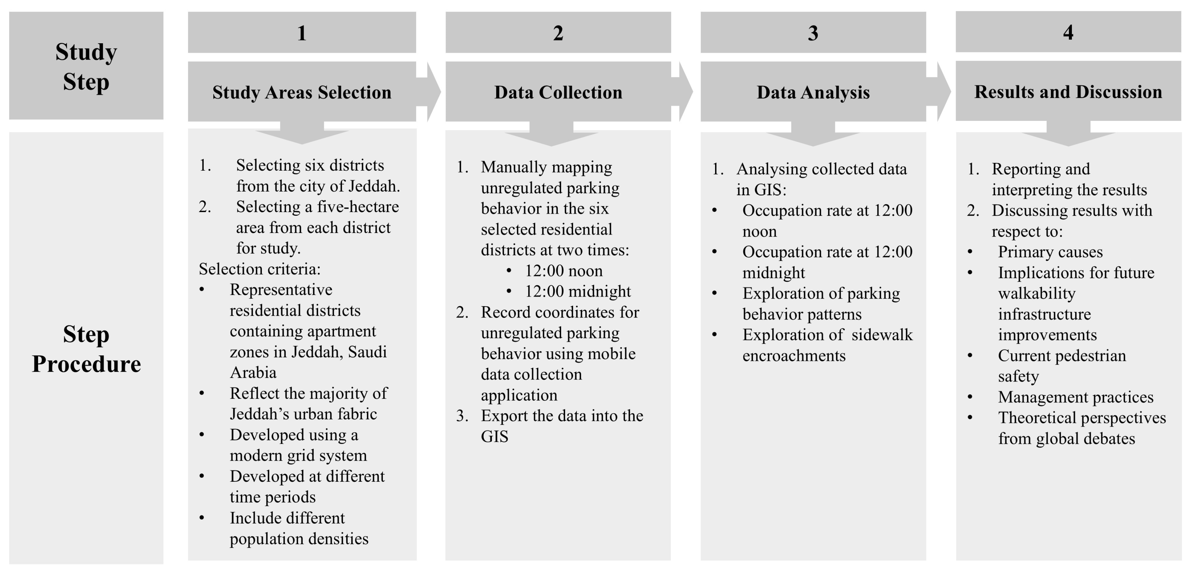
In addition to mapping on-street parking behaviors, we manually mapped major encroachments on sidewalks. These included parts of sidewalks that were removed to create car access to front setbacks or ground-floor private parking spaces. Mapping also included other modifications that resulted in partial or full blocking of sidewalks. We aimed to identify other permanent major obstacles affecting the use and continuity of existing sidewalk networks. We then used ArcGIS to process the collected data and calculate the land area of sidewalks being encroached. Figure 2 explains the entire study methodological framework.

5. Results

5.1. Parking Behaviors on Street Lane and Sidewalk Infrastructure

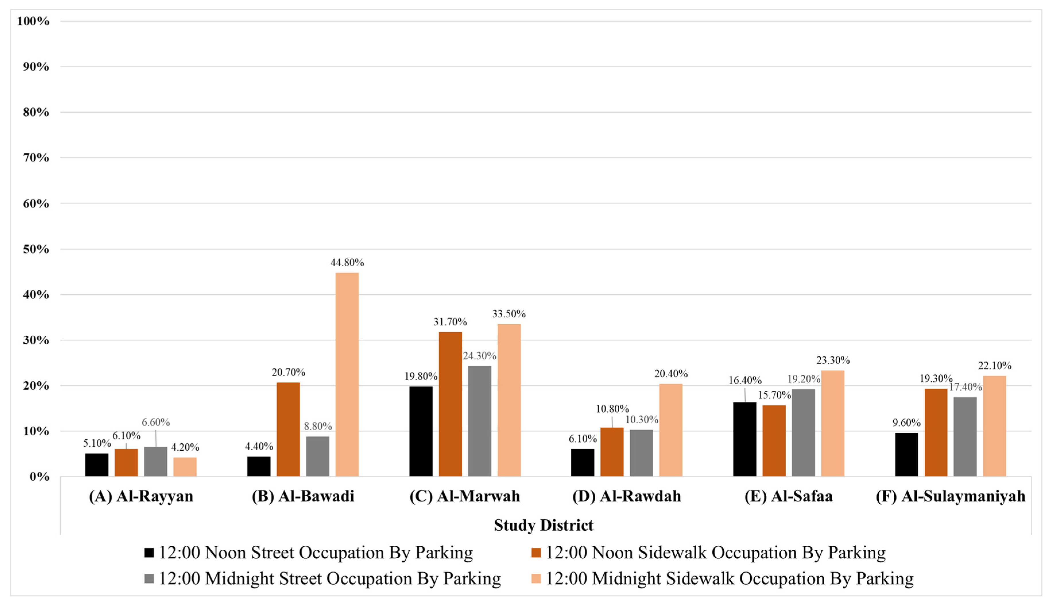
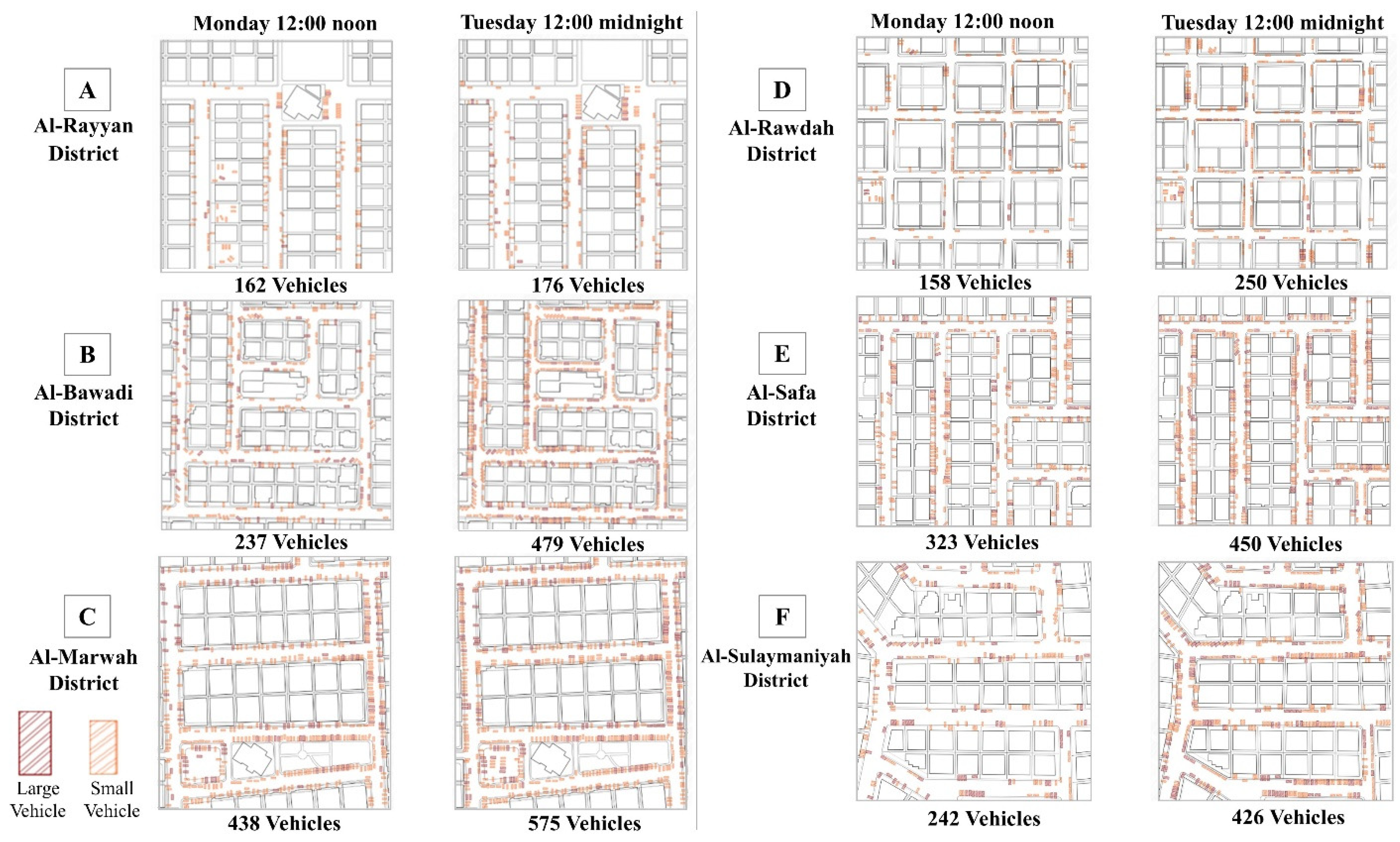
Table 2 presents the statistics on the total land areas of the six residential districts’ streets and sidewalks occupied by parking at 12:00 noon; Table 3 reports the statistics at 12:00 midnight. Table 4 presents the statistics on the number of vehicles parked at 12:00 noon and 12:00 midnight. Figure 3 presents a graphical illustration of the percentage of total street and sidewalk land areas occupied by parking in the six study districts during the two recorded periods. Figure 4 illustrates the number of parked vehicles and their distribution during the two periods.
The mapping process reveals varying rates of parking occupation of street and sidewalk land areas in both recorded periods. However, the occupation rates were higher at 12:00 midnight in all districts except district (A), which only reveals a slight decrease in sidewalk occupation during 12:00 midnight. The highest recorded number of parked vehicles at 12:00 noon was 438 (district C), while the lowest was 158 (district D). The highest number of parked vehicles at 12:00 midnight was 575 (district C), whereas the lowest was 176 (district A).

5.2. Mapping Patterns of Parking Behaviors

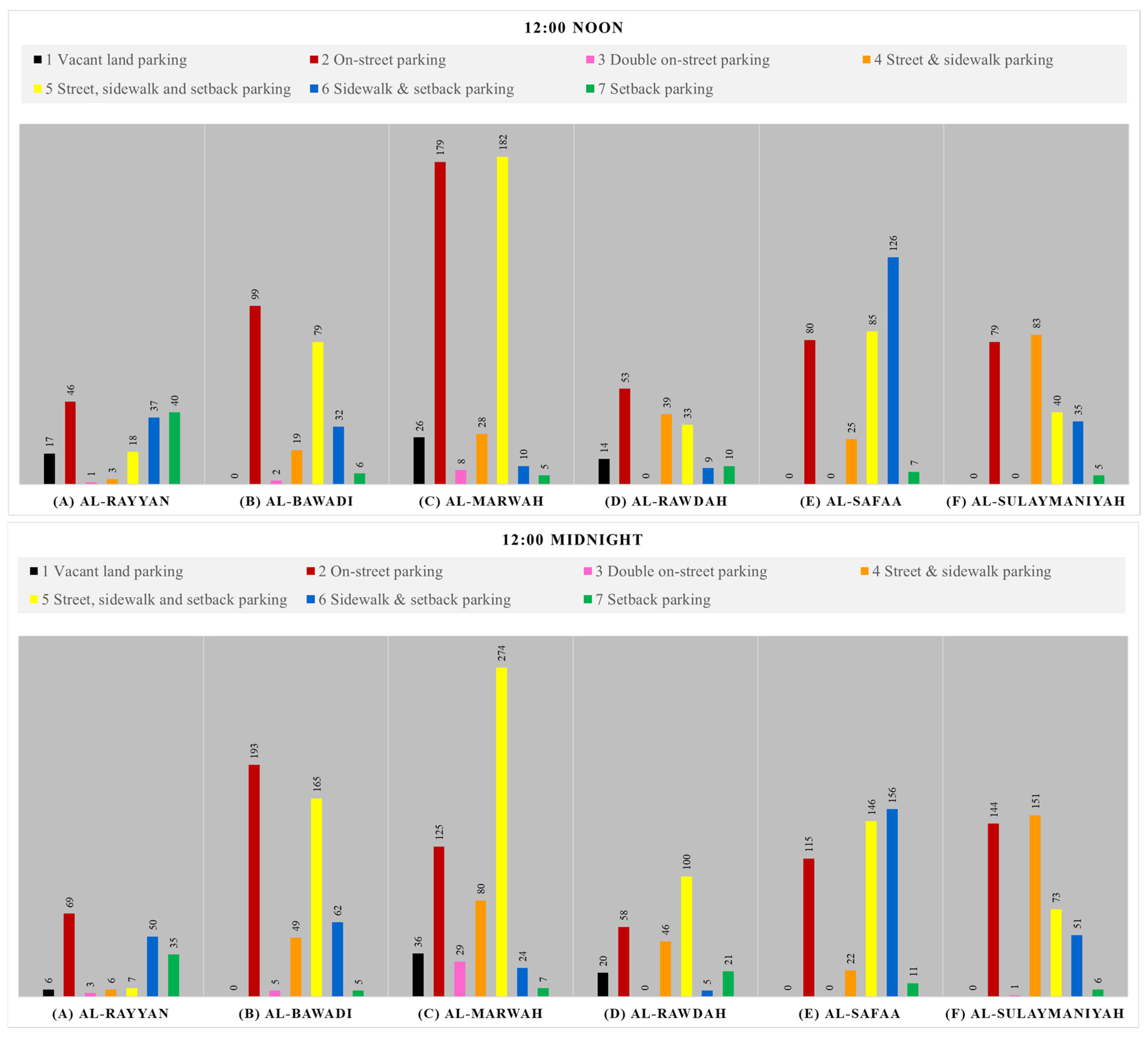
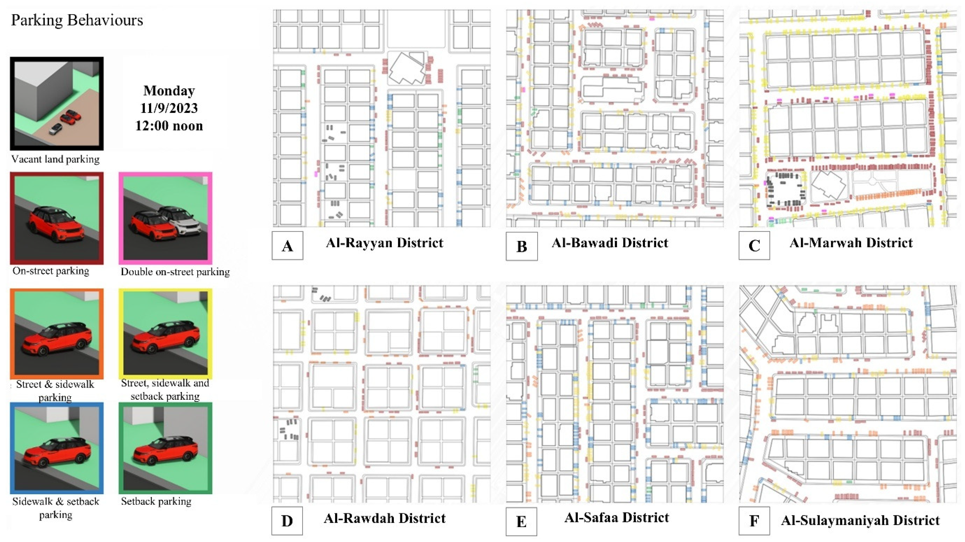
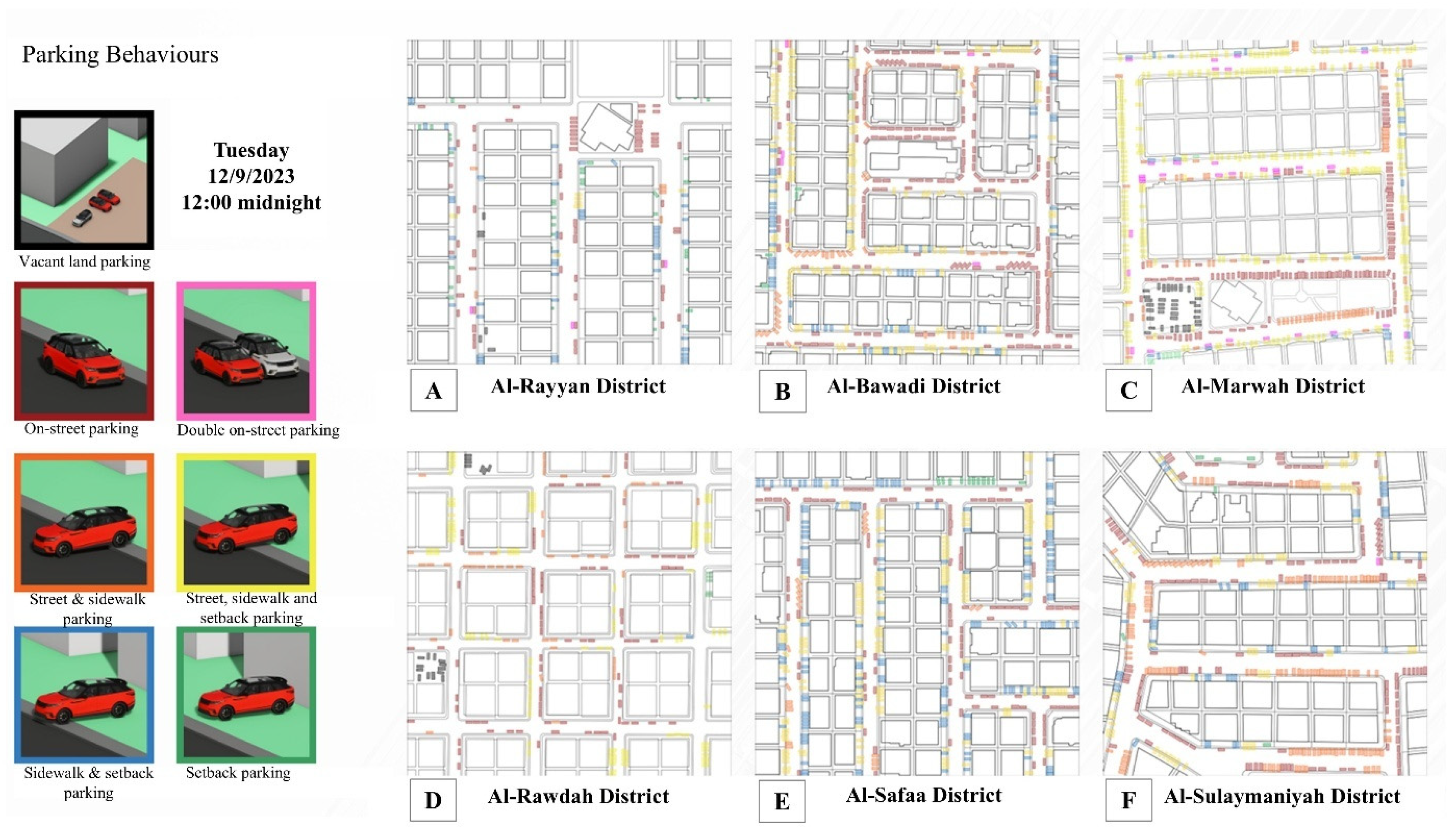
Table 5 and Table 6 report statistics on the parking behaviors in the six study districts at 12:00 noon and 12:00 midnight, respectively. Figure 5 illustrates the seven parking behaviors recorded across the six study districts during the two recorded periods. Figure 6 depicts the parking behaviors during the two recorded periods in the six districts.
The study identifies seven parking behavior patterns across the six districts. These include parking in vacant blocks, parking on streets (parallel or perpendicular to sidewalks), double on-street parking (one car parked parallel to a sidewalk and another parallel to the first car owing to the unavailability of curb parking), parking partly on the street and partly on the sidewalk, parking on three-parts (street, sidewalk, and setback), parking partly on sidewalks and partly on setbacks, and parking only in building setback areas. These parking behaviors differ between 12:00 noon and 12:00 midnight. At 12:00 noon, three districts (A, B, & D) have the highest on-street parking—28%, 42%, and 33%, respectively. District (C) records the highest parking behavior (42%) of three-part parking (street, sidewalk, and setback), district (E) records the highest parking behavior (39%) of two-part parking (sidewalk and setback), while district (F) records the highest parking behavior (34%) of another type of two-part parking (street and sidewalk). At 12:00 midnight, two districts (A and B) record the highest on-street parking—39% and 40%, respectively. Two other districts (C and D) record the highest parking behavior—48% and 40%, respectively—of three-part parking (street, sidewalk, and setback area). District (E) records the highest parking behavior (35%) of two-part parking (sidewalk and setback), whereas district (F) records the highest parking behavior (36%) of another type of two-part parking (street and sidewalk).

5.3. Mapping Sidewalk Encroachments

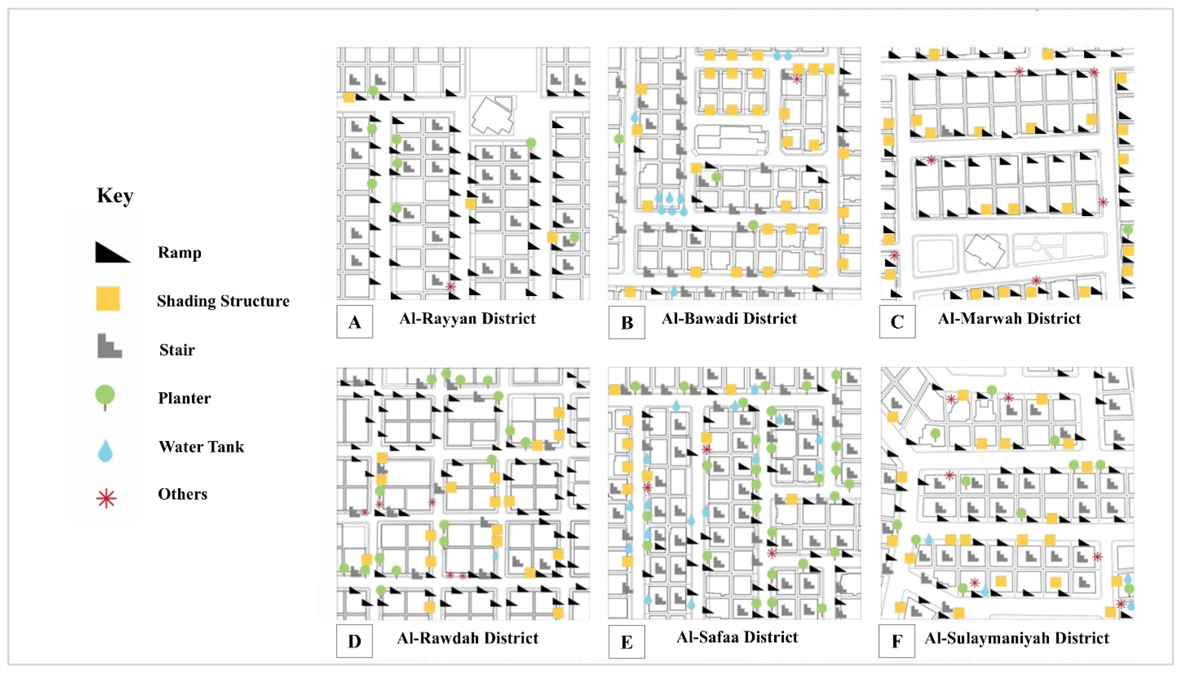
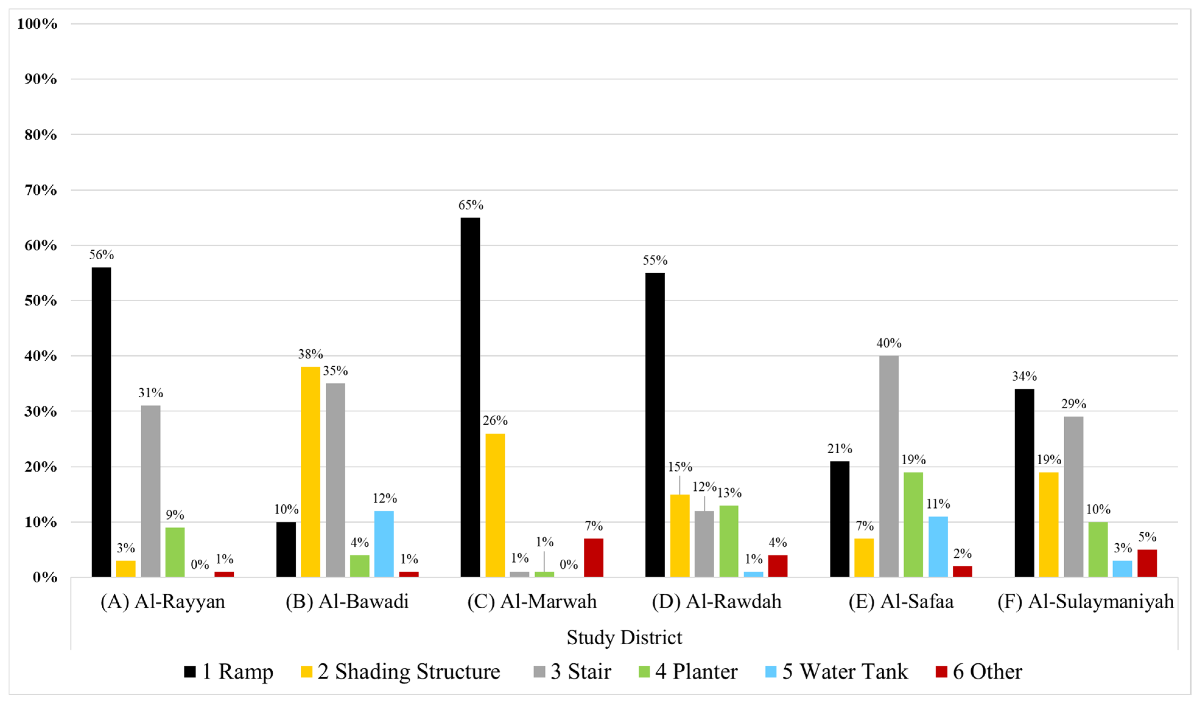
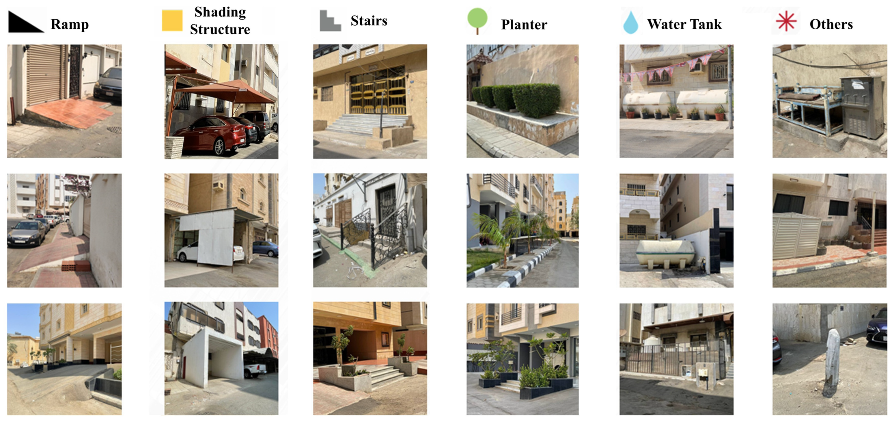
Table 7 and Table 8 present the statistics on the number and total land area of sidewalk encroachments in the six study districts, respectively. Figure 7 presents a graphical illustration showing the percentage of the sidewalk encroachment types in the six study districts. Figure 8 depicts examples of sidewalk encroachment types in the six districts. Figure 9 presents the distribution of sidewalk encroachment types in the six districts.
The study identifies six different types of sidewalk encroachments: ramps, shading structures for private vehicles, entrance stairs, planters, water tanks, and other physical obstacles (such as drinking water stations, concrete bollards, etc.). Ramps were the most common type of encroachment, followed by stairs and shading structures (built to protect vehicles from the hot sun).

5.4. Descriptive Analysis

The study findings indicate that current parking behaviors occupy varying rates of land areas: between 5.1% in Al-Rayyan district (A) to 19.8% in Al-Marwah district (C) for streets and between 6.1% in Al-Rayyan district (A) and 31.7% in Al-Marwah district (C) for sidewalks at 12:00 noon. This occupation increases at 12 midnight to range between 6.6% in Al-Rayyan district (A) to 24.3% in Al-Marwah district (C) for streets and between 4.2% in Al-Rayyan district (A) to 44.8% in Bawadi district (B) for sidewalks. The issue of parking recorded in the six study areas can be attributed to five shortcomings. First, Jeddah’s Local Plan 1440 applies the parking regulation, offering more parking by either necessitating one parking space for every 150 m square of the residential plot’s total land area or one parking space for each apartment unit. This parking regulation, applicable to new residential districts with four residential floors and a roof extension that includes two villa roofs, does not take into consideration Jeddah’s high ownership of private vehicles, estimated at 1.44 vehicles per family in 2016 [58]. This percentage has likely increased, as Jeddah recorded the highest road traffic density in Saudi Arabia, with 5.2 million vehicles and 167,000 daily trips in August 2019 [59]. This is because of the lack of a proper public transportation system, resulting in large traffic volumes beyond the capacity of existing road networks in certain districts of the city [60]. Second, Local Plan 1440 exempts the first roof villa in the roof extension from providing parking. Third, Local Plan 1440 does not update parking regulations for old buildings that do not follow the new regulations, despite an increase in car ownership. Fourth, the Local Plan 1440 does not explain how to create ground-floor parking without interfering with and encroaching upon nearby sidewalks. It does not clarify where to provide parking outside the premises if the ground floor is insufficient or whether parking alongside residential streets is restricted. Fifth, there are no street regulations that ban apartment building residents from parking their vehicles alongside residential streets. These shortcomings result in apartment building residents using sidewalks, setbacks, and significant parts of street lanes in front of their buildings for parking.
The lack of regulations pertaining to managing residential street parking in most of Jeddah’s residential districts has resulted in seven parking behaviors. At 12:00 noon, on-street parking behavior was the most predominant, representing 34% (536 vehicles) in the six study districts. Al-Bawadi district (B) recorded the highest on-street parking (42%) and the second highest three-part parking (street, sidewalk, and setback) (33%), because of the unavailability of ground-floor parking, as most existing buildings continue to follow their previous building code (two floors with no ground-floor parking) despite the increase in car ownership. Narrow street widths (8–11 m) magnify the issue of parking, as vehicles can barely pass. The implementation of the new building regulations of Jeddah’s Local Plan 1440 has also exaggerated this issue. Thus, new buildings being built according to the Local Plan 1440 will lead to more parking on streets, sidewalks, and setbacks.
Three-part parking, wherein vehicles are parked perpendicular to each building on three parts (street, sidewalk, and setback) to allow other vehicles to park and to prevent narrowing street width and slow traffic flow, is the next most common behavior, representing 28% (437 vehicles) at 12:00 noon in the six study districts. Al-Marwah district (C) recorded the highest percentage of this parking behavior (42%), although it includes ground-floor parking. These buildings include four residential floors and roof villas, but their ground-floor parking cannot accommodate the number of private vehicles for the residents of each building because of the high ownership of vehicles (≥2 for each apartment). Additionally, in this study area, 58 out of 60 buildings were constructed according to the new building regulations of Jeddah’s Local Plan 1440. This has resulted in a very high demand for parking, encouraging three-part parking behavior that allows residents to park without blocking the street traffic. This parking behavior was also high in other districts: 33% in Al-Bawadi district (B), 26% in Al-Safa district (F), and 21% in Al-Rawdah district (D).
At 12:00 midnight, three-part parking (street, sidewalk, and setback) was the highest across the six districts, increasing from 28% at 12:00 noon to 32% at midnight. Some districts witnessed a significant increase, such as Al-Rawdah (D), which recorded 40% at 12:00 midnight compared with 21% at 12:00 noon. In contrast, other districts such as Al-Rayyan (A) recorded a marked decrease in this parking behavior, falling to 4% at 12:00 midnight from 11% at 12:00 noon. This is perhaps because parking behaviors were mainly divided between on-street parking (39% at 12:00 midnight compared to 28% at 12:00 noon) and two-part parking (sidewalk and setback) (29% at 12:00 midnight compared to 23% at 12:00 noon).
Residential district characteristics such as the availability of undeveloped vacant lands, wider setbacks, and large public open spaces (POS) play a significant role in reducing the number of parked vehicles on streets, sidewalks, and setbacks at 12:00 noon. Al-Rayyan district (A) witnessed less on-street parking (28%) compared to Al-Bawadi district (B) and Al-Sulaymaniyah district (F), which recorded 42% and 33%, respectively, as the latter two do not have undeveloped vacant blocks and wider setbacks. Moreover, two-part parking (street and sidewalk) and three-part parking (street, sidewalk, and setback) in Al-Rayyan district (A) were lower than in the districts of Al-Bawadi (B), Al-Safaa (E), and Al-Sulaymaniyah (F). The availability of undeveloped blocks in the Al-Marwah district (C) slightly reduced the number of vehicles parked on streets, sidewalks, and setbacks to 26 at 12:00 noon from 36 at 12:00 midnight. However, the benefit of having undeveloped blocks is temporary, causing more parking on streets, sidewalks, and setbacks if these vacant lands are developed. Additionally, the large POS in Al-Marwah district (C) encourages more on-street parking, particularly for residents of buildings surrounding this space, thus reducing the rates of two-part parking (sidewalk and setback).
Lastly, parking on sidewalks impacts their availability for walking. This issue leads to permanent encroachments that affect sidewalk availability and use. As indicated in Figure 6, the conversion of sidewalks into ramps was highest in four districts, followed by the creation of shading structures and entrance stairs at varying rates. The conversion of sidewalks into ramps was primarily linked with new districts that provide ground-floor parking, such as Al-Marwah (C) 65%, Al-Rayyan (A) 56%, and Al-Rawdah (D) 55%, where new buildings are being developed according to Jeddah’s Local Plan 1440. The conversion of sidewalks into ramps and their occupation by other permanent encroachments have led to significant loss of land area across several districts (Table 8), estimated at 87% in Al-Rayyan (A), 81% in Al-Marwah (C), 77.8% in Al-Rawdah (D), 38.9% in Al-Sulaymaniyah (F), 34.4% in Al-Bawadi (B), and 16.2% in Al-Safaa (E). The issue of encroachments can be attributed to the lack of appropriate interpretation for creating access ramps to ground-floor parking according to Jeddah’s Local Plan 1440, as well as poor administration and monitoring of the implementation process and encroachments in residential districts. It is an issue that was present prior to the implementation of the Local Plan 1440 [13].

6. Discussion

This study investigated parking behaviors and their impact on street lanes and sidewalks across six representative residential districts in Jeddah, Saudi Arabia. Our findings reveal that, despite compliance with Jeddah’s Local Plan 1440 parking regulations, major parking issues were recorded. This suggests that parking provision is inadequate and does not align with the national car ownership rate in Saudi Arabia. Specifically, residential parking occupies a substantial portion of street lanes and sidewalks, primarily due to insufficient parking provision and regulatory oversight. Increasing the density in the apartment building zones, in the Local Plan 1440, from two residential floors to four, including allowing the building of two units (villas) on apartment roofs, has doubled or even tripled the density in each residential plot. This increase in population density without updated provisions for parking in a city characterized by high car ownership, an insufficient public transportation system [60], and lack of walkability infrastructure has led to significant deterioration in the public realm of residential districts. The issue of parking provision is not only limited to apartment building zones but also extends to include villa zones because of the allowance of dividing new residential land plots to include two small houses instead of one large house, without any proper standard regulations for parking [61].
The current parking provision and regulations of Jeddah’s Local Plan 1440 may not contribute positively to the Cities Humanization initiative, adopted by the QLP of the Vision 2030 to make Saudi cities’ residential areas walkable by all measures [62]. As this study found, the current parking issue in Jeddah’s residential streets has made it impossible to add new infrastructure for walkability or improve the quality of existing sidewalks, thereby hindering this initiative. The removal of sidewalk infrastructure reaches considerable rates in Jeddah’s new residential districts, such as Al-Rayyan district (A) and Al-Marwah district (C), estimated at 87% and 81%, respectively. It also reaches an extreme level in old residential areas like Al-Rawdah district (D) 77.8%, which has started to benefit from the additional residential floors. The sidewalk removal processes, linked to the exceptionally high demand for parking because of the high car ownership rate, aim to provide access to front setbacks and ground-floor parking, as the Local Plan 1440 does not illustrate how car access can be provided in different settings. Thus, addressing this issue must be prioritized to achieve this essential national initiative. This is because recent efforts to humanize public spaces in other Saudi cities, which still experience the same parking-related issue, have led to significant illegal parking on their new walking infrastructure [12].
The current parking regulations of Jeddah’s Local Plan 1440 impact pedestrians’ safety in different ways. First, with vehicles parking over front setbacks, this implies higher risk of pedestrians being struck and injured because drivers often do not pay full attention while backing up. Second, mandating ground-floor parking in new residential buildings has led to the creation of several conflict points between pedestrians using sidewalk infrastructure and driveways to ground-floor parking at the residential block level. For example, if a residential block has seven buildings, each with a ground-floor parking area with a separate entrance and exit, as in Al-Marwah district, it means that the sidewalk, which connects the seven buildings, is interrupted at 14 points. These conflict points may imply high risk when vehicles are parked in front setbacks, as drivers leaving the ground-floor parking will not be able to see pedestrians approaching from the side on the sidewalk or the street because of the partial view blockage by parked vehicles on front setbacks. Third, the high level of most ground-floor car parks from the street level, which can reach up to 1 m, may increase the risk of drivers not seeing pedestrians who cross the intersection points between driveways and sidewalks or streets. This situation may encourage pedestrians to choose to walk on streets rather than sidewalks due to the unavailability of pedestrian-friendly infrastructure, which could potentially increase the risk of traffic accidents [3]. Fourth, creating illegal ramps to completely or partially park vehicles over front setbacks have led some building owners to encroach on sidewalks for other uses (e.g., shading structures, entrance stairs, water tanks). Last, engaging in on-street parking to compensate for the current insufficient parking regulations, as noted in most of the studied districts, may double pedestrian traffic accidents [63].
Across the six study areas, residents exhibit seven distinct parking behaviors: parking on vacant land, on-street parking, double on-street parking, two-part parking (street and sidewalk), three-part parking (street, sidewalk and setback), the other two-part parking (sidewalk and setback), and setback-only parking. These patterns exemplify Informal Urbanism Theory [64], illustrating how residents adopt inadequate parking provision and management by filling the gaps through informal practice. Our findings also align with research on mobility behavior in car-dependent contexts [65], demonstrating that high car ownership, limited public transportation, and a preference for door-to-door access led drivers to minimize walking distances and often normalize illegal, improvised parking. Additionally, theories of Public Space Appropriation [66] highlight how repeated occupation and spatial claims allow users to gradually transform streets, sidewalks, and leftover spaces into extensions of private use—frequently at the expense of pedestrian movement and the quality of the public realm as documented at varying rates across the six study areas.
Several parking management strategies exist that regulate and limit random parking in residential streets, which eventually lead to more walkable communities. For example, Anirudh et al. [67] suggested a multi-strategy to deal with residential parking demand by applying the shared parking strategy, allowing for more efficient use of parking spaces by pooling them. This strategy necessitates improving public transit to reduce reliance on private vehicles and implementing flexible pricing and tax policies to offset the cost of parking and fund alternatives. Alhajaj [13] suggested the creation of multiple building garages along densely residential streets to provide additional paid parking for those who own a higher number of private vehicles that cannot be accommodated in their residential building’s ground-floor parking. Revenues collected from paid parking can be used to fund future plans to improve the residential public realm. The Chicago Metropolitan Agency for Planning [68] introduced a plan to support the development of compact, walkable communities and encourage communities to consider a wide array of solutions. It included (1) converting free of charge on-street parking into paid parking to manage high demand in dense areas; (2) setting maximum parking limitations in some locations; and (3) eliminating or reducing minimum parking requirements. Moreover, the Bellevue Curb Management Plan 2023 [69] applies multiple strategies to manage and control on-street parking in dense areas to protect sidewalks. Its strategies include (1) apply the Curb Typology tool, which involves assigning the space along sidewalks to either parking, loading or bikes based on the local needs; (2) apply fees to keep parking turning over, and reduce cruising time for searching for parking; and (3) track and tweak through using sensors, data, pilots and community input to improve enforcement and residents’ safety. Another strategy focuses on protecting sidewalks by locating parking behind buildings to create more enjoyable and walkable routes for pedestrians [42]. For Jeddah’s current residential areas, a hybrid strategy involving adding multiple building garages along densely residential streets may be appropriate to deal with the high demand for parking because of high vehicle ownership in the country; however, this necessitates further research. Improvements to the current transit system could also contribute to reducing reliance on private vehicles. Potential reforms to the parking regulations of Jeddah’s Local Plan 1440 might include increasing the number of residential parking floors to better accommodate the current rate of private car ownership per family. These measures may help protect existing sidewalk infrastructure from parking encroachments and support the implementation of the Cities Humanization initiative in residential streets.
Municipalities in major Saudi cities need to establish their own residential parking codes and regulations to safeguard existing and future walkability infrastructure. This includes elements such as sidewalks and urban trees that are essential for creating a walk-friendly environment [70]. Municipality departments responsible for developing parking codes and regulations in residential areas should conduct regular site audits to assess whether approved standards function effectively under real-world conditions. These departments should also improve coordination between parking planning and broader land use planning, as the lack of coordination has caused several parking provision challenges in many major Saudi cities [52]. Addressing the parking issue is crucial, as has been highlighted in several news articles. If left unresolved, it may lead to increased illegal parking, on-street parking, and the deterioration of existing and future sidewalk infrastructure [71]. Therefore, strengthening parking management through designated residential parking policies, physical demarcation of legal parking zones, and enforcement mechanisms can mitigate the spatial conflicts observed between parked vehicles and pedestrian areas. Embedding these measures within a broader urban design agenda will help translate the research insight into practical action-enhancing walkability, protecting pedestrian infrastructure, and supporting more sustainable urban mobility outcomes.

7. Conclusions

This study investigated unregulated parking behaviors and their impact on sidewalks and street infrastructure in six representative residential districts in Jeddah, Saudi Arabia. This is because this issue is perceived as a barrier to achieving the Improvement of the Urban Landscape strategic goal and the Cities Humanization initiative of the Saudi Vision 2030. This study found that residential parking occupies a significant land area of street lanes and sidewalks because of the lack of appropriate parking provision and regulations. This study contributes to the literature in three ways. First, it extends current research on mapping parking behaviors, particularly in residential areas. Second, it extends the limited Saudi literature that has hitherto focused on commercial streets, ignoring residential streets. Lastly, it extends the literature on how inappropriate consideration of an essential planning element of the built environment, which in our case is parking provision, can lead to the degradation of the walkability infrastructure in residential streets.
This study is limited to mapping the behavior of parking in residential streets to investigate its impact on street lanes and sidewalk infrastructure. However, it does not address possible differences in parking behaviors during other periods (such as school drop-off times or evening social hours), nor does it consider seasonal or weekly variations (e.g., weekdays versus weekends), as the data collection was designed to capture representative peak and off-peak conditions within the available time and resource constraints. It also does not investigate a reasonable parking standard for a city with a high density and an insufficient public transit system, or the parking strategies needed to mitigate the current situation. In addition, this study does not examine the social, behavioral, and governance drivers of unregulated parking behavior, such as household mobility patterns, cultural norms, and planning deficiencies. Moreover, it does not compare Jeddah’s Local Plan parking regulations with those of other Saudi cities’ plans or with similar Middle Eastern contexts. Further research on such limitations is important not only for Jeddah but also for other cities worldwide in similar situations.

Author Contributions

Conceptualization, N.A. and A.H.; methodology, N.A.; software, N.A., A.H. and A.A.; validation, N.A., A.H. and A.A.; formal analysis, N.A.; investigation, N.A., A.H. and A.A.; resources, A.H. and A.A.; data curation, N.A., A.H. and A.A.; writing—original draft preparation, N.A.; writing—review and editing, N.A., A.H. and A.A.; visualization, N.A., A.H. and A.A.; supervision, N.A., A.H. and A.A.; project administration, N.A.; funding acquisition, N.A. All authors have read and agreed to the published version of the manuscript.

Funding

This project was funded by the Deanship of Scientific Research (DSR) at King Abdulaziz University, Jeddah, Saudi Arabia, under grant no. (IPP: 740-137-2025). The authors, therefore, acknowledge with thanks DSR for technical and financial support.

Data Availability Statement

The original contributions presented in this study are included in the article. Further inquiries can be directed to the corresponding author.

Acknowledgments

The authors are grateful to Basil Al-Nahdi, Mohammad Al-Harthi, Ahmed Al-Ghamdi, Abdullah Qahtan, and Sulaiman Mirza—students who assisted in data collection and the production of some visualizations during the Urban Design Studio of 2023–2024 under the authors’ supervision.

Conflicts of Interest

The authors declare no conflicts of interest.

Abbreviations

The following abbreviations are used in this manuscript:
GISGeographic Information System
POSsPublic Open Spaces
QLPQuality-of-Life Program

References

  1. Wei, J.; Wu, Y.; Zheng, J.; Nie, P.; Jia, P.; Wang, Y. Neighborhood sidewalk access and childhood obesity. Obes. Rev. 2021, 22, e13057. [Google Scholar] [CrossRef]
  2. Kwarteng, J.L.; Schulz, A.J.; Mentz, G.B.; Zenk, S.N.; Opperman, A.A. Associations between observed neighborhood characteristics and physical activity: Findings from a multiethnic urban community. J. Public Health 2014, 36, 358–367. [Google Scholar] [CrossRef]
  3. Honiball, J.E.; Burger, E.A.; Burger, Y. Pedestrian connectivity: A focus on residential neighbourhood sidewalks to promote accessibility to public parks. Spatium 2024, 51, 1–10. [Google Scholar] [CrossRef]
  4. Li, W.; Procter-Gray, E.; Lipsitz, L.A.; Leveille, S.G.; Hackman, H.; Biondolillo, M.; Hannan, M.T. Utilitarian walking, neighborhood environment, and risk of outdoor falls among older adults. Am. J. Public Health 2014, 104, e30–e37. [Google Scholar] [CrossRef] [PubMed]
  5. Lavizzo-Mourey, R.; McGinnis, J.M. Making the case for active living communities. Am. J. Public Health 2003, 93, 1386–1388. [Google Scholar] [CrossRef] [PubMed]
  6. Salma, S. Saudi Arabia Plans to Set Maximum Limit for Household Vehicles. Gulf News, 18 June 2020. Available online: https://gulfnews.com/world/gulf/saudi/saudi-arabia-plans-to-set-maximum-limit-for-household-vehicles-1.72108605 (accessed on 18 June 2025).
  7. General Authority for Statistics. General Authority for Statistics for Saudi Arabia. 2019. Available online: https://www.stats.gov.sa/en (accessed on 1 July 2025).
  8. Alsalem, S. The Parking Crisis in Front of Residential Apartments Reflects the Lack of Proper Planning. Alriyadh Newspaper, 13 June 2010. Available online: https://www.alriyadh.com/534483 (accessed on 19 July 2025).
  9. Al-Shuraimi, A. Parking Challenges and Solutions. Alwatan Newspaper, 29 October 2024. Available online: https://www.alwatan.com.sa/article/1155441 (accessed on 22 July 2025).
  10. Khalil, Y. Awareness and Neighborly Appreciation can Avoid Problems: Parking Spaces are a Recurring Crisis within Neighborhoods. Al-Bilad Newspaper, 9 May 2024. Available online: https://albiladdaily.com/2024/05/09/%D8%A7%D9%84%D9%88%D8%B9%D9%8A-%D9%88%D8%AA%D9%82%D8%AF%D9%8A%D8%B1-%D8%A7%D9%84%D8%AC%D8%A7%D8%B1-%D9%83%D9%81%D9%8A%D9%84%D8%A7%D9%86-%D8%A8%D8%AA%D8%AC%D9%86%D8%A8-%D8%A7%D9%84%D9%85%D8%B4%D8%A7/ (accessed on 22 July 2025).
  11. Hashwan, K. Vehicle Parking within Neighborhoods. 2023. Available online: https://www.al-madina.com/article/830681/ (accessed on 19 July 2025).
  12. Al-Suliman, K. Sidewalks Without Pedestrians. Okaz Newspaper, 10 June 2024. Available online: https://www.okaz.com.sa/articles/authors/2163575 (accessed on 20 July 2025).
  13. Alhajaj, N. New Forms of Public Open Space in the City of Jeddah: Urban Design Scenarios for Increasing the Provision of POS to Enhance the Urban Health of a Rapidly Growing Saudi Arabian Metropolis. Ph.D. Thesis, University of Western Australia, Crawley, WA, Australia, 2014. [Google Scholar]
  14. Rahman, M.T.; Nahiduzzaman, K.M. Examining the walking accessibility, willingness, and travel conditions of residents in Saudi Cities. Int. J. Environ. Res. Public Health 2019, 16, 545. [Google Scholar] [CrossRef]
  15. Koohsari, M.J.; Karakiewicz, J.A.; Kaczynski, A.T. Public open space and walking: The role of proximity, perceptual qualities of the surrounding built environment, and street configuration. Environ. Behav. 2012, 45, 706–736. [Google Scholar] [CrossRef]
  16. Saudi Arabia Vision 2030. Saudi Vision 2023: Turning Towards a Promising Future. 2025. Available online: https://www.vision2030.gov.sa/ (accessed on 20 July 2025).
  17. Quality of Life Program. 17 December 2025. Available online: https://www.vision2030.gov.sa/ar/explore/programs/quality-of-life-program (accessed on 20 July 2025).
  18. Ministry of Municipal and Rural Affairs (MOMRA) and UN-Habitat. Jeddah City Profile. 2019. Available online: https://unhabitat.org/jeddah-city-profile (accessed on 22 August 2024).
  19. Ministry of Municipal and Rural Affairs (MOMRA) and UN-Habitat. Jeddah CPI Profile. 2019. Available online: https://unhabitat.org/sites/default/files/2020/04/cpi_profile_for_jeddah_2019.pdf (accessed on 22 July 2025).
  20. Alrajhi, A. Residents of Marwa, Jeddah, Complain About Traffic Congestion and Visual Distortion. Sabq Newspaper, 23 January 2023. Available online: https://sabq.org/saudia/72w9u3izcj (accessed on 19 July 2025).
  21. Al-Nashri, T. Parking Spaces within Neighborhoods: The Problem and Solutions. Okaz Newspaper, 18 April 2024. Available online: https://www.okaz.com.sa/articles/people-voice/2159728 (accessed on 19 July 2025).
  22. Cambridge Dictionary. Unregulated. Available online: https://dictionary.cambridge.org/dictionary/english/unregulated (accessed on 21 July 2025).
  23. Jeddah Municipality. Jeddah’s Local Plan 1440: Building Regulations (In Arabic Language). 2018. Available online: https://www.scribd.com/document/570234222/Local-Plan-1440 (accessed on 16 September 2024).
  24. Ministry of Municipalities and Housing (MOMH). Guide for Designing Cars Parking, Saudi Arabia (In Arabic). 2019. Available online: https://sbc.gov.sa/ar/BC/Lists/SBCTechnicalEvidence/Attachments/168/20.pdf (accessed on 7 August 2024).
  25. Tuan Vu, A. Analysis of illegal parking behavior in Hanoi City. J. EASTS 2017, 12, 421–437. [Google Scholar]
  26. Shoup, D. Informal parking on sidewalks: The broken window effect. Calif. Policy Options 2014, 145–162. [Google Scholar]
  27. Cima, B.; Hildebrand, L. Evaluation of Washington, D.C. Parking Enforcement Program; Prepared for the U.S. DOT; Report No. UMTA MA-06-0049-82-10; U.S. Department of Transportation: Washington, DC, USA, 1982.
  28. May, A.; Turvey, R. The Effects of Wheel Clamps in Central London: Comparison Before and After Studies; Institute of Transport Studies: Leeds, UK, 1984. [Google Scholar]
  29. Mulder, T. The Use of Wheel Clamps at Parking Meters in Amsterdam. In PTRC Conference Paper; PTRC Education and Research Services Ltd.: London, UK, 1985. [Google Scholar]
  30. Spiliopoulou, C.; Antoniou, C. Analysis of illegal parking behavior in Greece. Procedia Soc. Behav. Sci. 2012, 48, 1622–1631. [Google Scholar] [CrossRef]
  31. Graham, D.J.; Naik, C.; McCoy, E.J.; Li, H. Do speed cameras reduce road traffic collisions? PLoS ONE 2019, 14, e0221267. [Google Scholar] [CrossRef] [PubMed]
  32. Bhat, S.; Martinez, J. Streets Get More Dangerous When Speed Cameras Are Off, Stats Show. The City, 16 May 2022. Available online: https://www.thecity.nyc/2022/5/16/23077805/speed-enforcement-cameras-nights-weekends (accessed on 10 November 2025).
  33. Popescu, R. The culture of parking on the sidewalks. Cities 2022, 131, 103888. [Google Scholar] [CrossRef]
  34. Bradley, M.; Layzell, P. Parking Behaviour in a Suburban Town Centre: An Analysis of Town Surveys in Kingston Upon Thames; Report 354; Transport Studies Unit, University of Oxford: Oxford, UK, 1986. [Google Scholar]
  35. Polak, J.; Cullinane, K. Illegal parking and the enforcement of parking regulations: Causes, effects and interactions. Transp. Rev. 1992, 12, 49–75. [Google Scholar] [CrossRef]
  36. Moran, M.E. Eyes on the bike lane: Crowdsourced traffic violations and bicycle infrastructure in San Francisco, CA. Transp. Find. 2020. [Google Scholar] [CrossRef]
  37. Kuntzman, G. New York City’s Pedestrian Death Crisis Is Part of an Alarming and Ongoing National Trend. Streetsblog NYC, 8 April 2022. Available online: https://nyc.streetsblog.org/2022/04/08/new-york-citys-pedestrian-death-crisis-is-part-of-an-alarming-and-ongoing-national-trend/ (accessed on 12 June 2025).
  38. Kurnicki, K. How to park a car? Immobility and the temporal organization of parking practices. Mobilities 2020, 15, 708–724. [Google Scholar] [CrossRef]
  39. Jacobs, J. The Death and Life of Great American Cities; Vintage Books: New York, NY, USA, 1961. [Google Scholar]
  40. Gehl, J. Cities for People; Island Press: Washington, DC, USA, 2010. [Google Scholar]
  41. OAR. Raportul Pentru Bucuresti (Report for Bucharest); PIM: Iasi, Romania, 2018. [Google Scholar]
  42. Zuniga-Teran, A.A.; Orr, B.J.; Gimblett, R.H.; Chalfoun, N.V.; Guertin, D.P.; Marsh, S.E. Neighborhood design, physical activity, and wellbeing: Applying the walkability model. Int. J. Environ. Res. Public Health 2017, 14, 76. [Google Scholar] [CrossRef]
  43. Knapskog, M.; Hagen, O.H.; Tennøy, A.; Rynning, M.K. Exploring ways of measuring walkability. Transp. Res. Procedia 2019, 41, 264–282. [Google Scholar] [CrossRef]
  44. Litman, T. Parking Management—Strategies, Evaluation and Planning; Victoria Transport Policy Institute: Victoria, BC, Canada, 2024; Available online: https://www.vtpi.org/park_man.pdf (accessed on 5 November 2025).
  45. Calthrop, E.; Proost, S.; Van Dender, K. Parking policies and road pricing. Urban Stud. 2000, 37, 63–76. [Google Scholar] [CrossRef]
  46. Petiot, R. On-Street Parking Fees, Optimal Fines and Individual Decision-Making. In Proceedings of the Selected Proceedings of the 9th World Conference on Transport Research, Seoul, Republic of Korea, 22–27 July 2001; Available online: https://trid.trb.org/view/698928 (accessed on 8 November 2025).
  47. Teknomo, K.; Kazunori, H. Parking behavior in central business district: A study case of Surabaya, Indonesia. EASTS J. 1997, 2, 551–570. [Google Scholar]
  48. Ünsal, O. A GIS-Based Tool to Assess the Impact of Unregulated Parking on Urban Road Capacity. Master’s Thesis, Middle East Technical University, Ankara, Turkey, 2024. [Google Scholar]
  49. Kirschner, F. Parking and competition for space in urban neighborhoods: Residents’ perceptions of traffic and parking-related conflicts. J. Transp. Land Use 2021, 14, 603–623. [Google Scholar] [CrossRef]
  50. Schlossberg, M.; Amos, D. Rethinking residential on-street parking. In Retrofitting Sprawl: Addressing Seventy Years of Failed Urban Form; Talen, E., Ed.; University of Georgia Press: Athens, GA, USA, 2015; pp. 181–198. Available online: http://www.jstor.org/stable/j.ctt183q43f.12 (accessed on 8 November 2025).
  51. Guo, Z. Residential street parking and car ownership: A study of households with off-street parking in the New York City region. J. Am. Plan. Assoc. 2013, 79, 32–48. [Google Scholar] [CrossRef]
  52. Al-Fouzan, S. Using car parking requirements to promote sustainable transport development in the Kingdom of Saudi Arabia. Cities 2012, 29, 201–211. [Google Scholar] [CrossRef]
  53. Aljoufie, M. Analysis of illegal parking behavior in Jeddah. Curr. Urban Stud. 2016, 4, 393–408. [Google Scholar] [CrossRef][Green Version]
  54. Zambonini, S.; Loghin, A.M.; Pfeifer, N.; Soley, E.M.; Sablatnig, R. Detection of parking cars in stereo satellite images. Remote Sens. 2020, 12, 2170. [Google Scholar] [CrossRef]
  55. Deming, E.; Swaffield, S. Landscape Architecture Research: Inquiry, Strategy, Design; John Wiley & Sons, Inc.: Hoboken, NJ, USA, 2011. [Google Scholar]
  56. Moran, M.E. Authorized vehicles only: Police, parking, and pedestrian access in New York City. Transp. Res. Interdiscip. Perspect. 2023, 19, 100816. [Google Scholar] [CrossRef]
  57. Alhajaj, N.; Hendrigan, C. Out of sight and out of reach: Public access strategies using a mixed method to reconnect a Saudi urban mega-district with its shoreline. Coast. Manag. 2022, 50, 325–345. [Google Scholar] [CrossRef]
  58. King Abdullah Petroleum Studies and Research Center. Estimating Regional Variation in Saudi Arabia’s Energy Usage and Carbon Emissions; King Abdullah Petroleum Studies and Research Center: Riyadh, Saudi Arabia, 2023; Available online: https://www.kapsarc.org/our-offerings/publications/estimating-regional-variation-in-saudi-arabia-s-energy-usage-and-carbon-emissions (accessed on 24 September 2024).
  59. Ministry of Transport and Logistic Services (MOTLS). Saudi Transportation Ministry: 18 Million Road Trips in August. 2019. Available online: https://cdn.saudigazette.com.sa/article/576392/BUSINESS/18-million-road-trips-recorded-in-August (accessed on 9 September 2025).
  60. Aljoufie, M.; Tiwari, A. Modeling road safety in car-dependent cities: Case of Jeddah City, Saudi Arabia. Sustainability 2021, 13, 1816. [Google Scholar] [CrossRef]
  61. Alzamel, W. The Problem of Parking Spaces in Residential Neighborhoods. Makkah Newspaper, 18 September 2021. Available online: https://makkahnewspaper.com/article/1547058/ (accessed on 19 July 2025).
  62. Ministry of Municipalities and Housing (MOMH). Humanizing Cities. 2025. Available online: https://momah.gov.sa/en/initiatives/humanizing-cities (accessed on 15 September 2025).
  63. Congiu, T.; Sotgiu, G.; Castiglia, P.; Azara, A.; Piana, A.; Saderi, L.; Dettori, M. Built environment features and pedestrian accidents: An Italian retrospective study. Sustainability 2019, 11, 1064. [Google Scholar] [CrossRef]
  64. Roy, A. Urban Informality: Toward an Epistemology of Planning. J. Am. Plan. Assoc. 2005, 71, 147–158. [Google Scholar] [CrossRef]
  65. Shoup, D. The High Cost of Free Parking; Planners Press: Brooklyn, NY, USA, 2005. [Google Scholar]
  66. Lefebvre, H. The Production of Space; Nicholson-Smith, D., Translator; Blackwell: Hoboken, NJ, USA, 1991. [Google Scholar]
  67. Anirudh, B.; Mazumder, T.N.; Das, A. A contemporary review of residential parking lessons for Indian cities. Hous. Policy Debate 2021, 33, 573–596. [Google Scholar] [CrossRef]
  68. Chicago Metropolitan Agency for Planning. Support Development of Compact, Walkable Communities. 2018. Available online: https://cmap.illinois.gov/regional-plan/goals/recommendation/support-development-of-compact-walkable-communities/ (accessed on 10 September 2025).
  69. City of Bellevue. Curb Management. Transportation Department. 2023. Available online: https://bellevuewa.gov/city-government/departments/transportation/safety-and-maintenance/curb-management (accessed on 29 December 2025).
  70. Anuntavachakorn, P.; Pawarana, P.; Wongvorachan, T.; Thampanichwat, C.; Bunyarittikit, S. Exploring sidewalk built environment design strategies to promote walkability in tropical humid climates. Buildings 2025, 15, 2659. [Google Scholar] [CrossRef]
  71. Shoup, D. The trouble with minimum parking requirements. Transp. Res. Part A Policy Pract. 2002, 33, 549–574. [Google Scholar] [CrossRef]
Figure 1. The six residential districts selected for this study.
Buildings 16 00272 g001
Figure 2. The study methodological framework.
Buildings 16 00272 g002
Figure 3. Graphical illustration of the percentage of total street and sidewalk land areas occupied by parking in the six study districts during the two recorded periods.
Buildings 16 00272 g003
Figure 4. Distribution and number of parked vehicles during the two recorded periods in the six residential districts.
Buildings 16 00272 g004
Figure 5. Graphics illustrations showing statistics on the seventh parking behaviors in the six study districts during the two recorded periods.
Buildings 16 00272 g005
Figure 6. The six districts showing the parking behaviors during the two recorded periods.
Buildings 16 00272 g006aBuildings 16 00272 g006b
Figure 7. Graphical illustration of the percentage of different sidewalk encroachment types across the six residential districts.
Buildings 16 00272 g007
Figure 8. Examples of the major sidewalk encroachment types in the six residential districts.
Buildings 16 00272 g008
Figure 9. Distribution of sidewalk encroachment types in the six residential districts.
Buildings 16 00272 g009
Table 1. Information about the six residential districts selected for this study.
Urban FactorsResidential District
ABCDEF
Al-RayyanAl-BawadiAl-MarwahAl-RawdahAl-SafaaAl-Sulaymaniyah
Number of residential buildings 498360597357
Current (original) building heightA new district dominated by 4- to 5-floor buildings with ground-floor parking.An old district dominated by 2-floor buildings without ground-floor parking. However, 17 buildings recently built were based on the new building regulations, providing 5 floors and ground-floor parking. A new district with almost all buildings having 6 floors plus ground-floor parking. However, 2 buildings had only 3 floors and no ground-floor parking An old district dominated by 2- to 3-floor buildings without ground-floor parking. However, 26 recent buildings were built based on the new building regulations, providing 5 floors and ground-floor parking.An old district dominated by 2- to 3-floor buildings without ground-floor parking. Also, a few old buildings added one more floor to become 4-floor buildings without providing ground-floor parking. However, 3 recent buildings were built based on the new building regulations, providing 5 floors and ground-floor parking.An old district dominated by 3-floor buildings without ground-floor parking. However, 4 recent buildings were built based on the new building regulations, providing 5 floors and ground-floor parking.
Modification in building height regulationFour residential floors plus a ground-floor parking and a roof extension
Number of buildings providing ground-floor parking within their perimeters 49 11582634
Other forms of parking On-street and setback parking
Street width range 3.5–14 m8–11 m4–14 m6–12 m10 m10–15 m
Residential density *29–43 P/H192–313 P/H192–313 P/H192–313 P/H192–313 P/H44–70 P/H
* Data is based on the Jeddah City Profile [18].
Table 2. Statistics on street and sidewalk land areas occupied by parking at 12:00 noon.
Study DistrictTotal Existing Land AreaTotal Land Area Occupied by Parking
at 12:00 Noon
StreetSidewalkStreetSidewalk
AAl-Rayyan10,231 m21826.9 m2526.4 m25.1%112 m26.1%
BAl-Bawadi14,226.2 m22767.6 m2626.5 m24.4%571.7 m220.7%
CAl-Marwah14,374 m22343 m22848 m219.8%743.2 m231.7%
DAl-Rawdah12,783.4 m23402.8 m2779.9 m26.1%367.5 m210.8%
EAl-Safaa10,756 m22435.3 m21761.7 m216.4%382.9 m215.7%
FAl-Sulaymaniyah16,350 m22489 m21574.2 m29.6%480.6 m219.3%
Table 3. Statistics on street and sidewalk land areas occupied by parking at 12:00 midnight.
Study DistrictTotal Existing Land AreaTotal Land Area Occupied by Parking
at 12:00 Midnight
StreetSidewalkStreetSidewalk
AAl-Rayyan10,231 m21826.9 m2679.7 m26.6%75.9 m24.2%
BAl-Bawadi14,226.2 m22767.6 m21246 m28.8%1238.9 m244.8%
CAl-Marwah14,374 m22343 m23495 m224.3%785.4 m233.5%
DAl-Rawdah12,783.4 m23402.8 m21314.1 m210.3%694.2 m220.4%
EAl-Safaa10,756 m22435.3 m22065.1 m219.2%567.5 m223.3%
FAl-Sulaymaniyah16,350 m22489 m22852.2 m217.4%549.6 m222.1%
Table 4. Statistics on the number of vehicles parked on the streets and the sidewalks of the six residential districts.
Study DistrictNumber of Vehicles ParkedIncrease in VehiclesPercentage of
Increase
12:00 Noon12:00 Midnight
AAl-Rayyan162176148.6%
BAl-Bawadi237479242102%
CAl-Marwah43857513731.7%
DAl-Rawdah1582509258.2%
EAl-Safaa32345012739.3%
FAl-Sulaymaniyah24242618476%
Table 5. Statistics on parking behaviors across the six residential districts at 12:00 noon.
Study DistrictParking Behaviors at 12:00 Noon
1234567
Vacant LandOn-StreetDouble On-StreetStreet and SidewalkStreet, Sidewalk, and SetbackSidewalk and SetbackSetback
n *%n *%n *%n *%n *%n *%n *%
AAl-Rayyan1710%4628%11%32%1811%3723%4025%
BAl-Bawadi00%9942%21%198%7933%3213%63%
CAl-Marwah266%17941%82%286%18242%102%51%
DAl-Rawdah149%5333%00%3925%3321%96%106%
EAl-Safaa00%8025%00%258%8526%12639%72%
FAl-Sulaymaniyah00%7933%00%8334%4017%3514%52%
Total parked vehicles574%53634%111%19712%43728%24916%735%
* n: Number of parked vehicles.
Table 6. Statistics on parking behaviors across the six residential districts at 12:00 midnight.
Study DistrictParking Behaviors at 12:00 Midnight
1234567
Vacant LandOn-StreetDouble On-StreetStreet and SidewalkStreet, Sidewalk, and SetbackSidewalk and SetbackSetback
n *%n *%n *%n *%n *%n *%n *%
AAl-Rayyan63%6939%32%63%74%5029%3520%
BAl-Bawadi00%19340%51%4910%16535%6213%51%
CAl-Marwah366%12522%295%8014%27448%244%71%
DAl-Rawdah208%5823%00%4618%10040%52%219%
EAl-Safaa00%11526%00%225%14632%15635%112%
FAl-Sulaymaniyah00%14434%10%15136%7317%5112%61%
Total parked vehicles623%70430%382%35415%76532%34815%853%
* n: Number of parked vehicles.
Table 7. Statistics about the number of sidewalk encroachments in the six residential districts.
Study DistrictType of EncroachmentTotal
RampShading StructureStairPlanterWater TankOther
n *%n *%n *%n *%n *%n *%
AAl-Rayyan4956%33%2731%89%00%11%88
BAl-Bawadi910%3338%3035%34%1012%11%86
CAl-Marwah5865%2326%11%11%00%67%89
DAl-Rawdah6655%1815%1512%1613%11%54%121
EAl-Safaa3121%107%5940%2819%1611%32%147
FAl-Sulaymaniyah3834%2119%3229%1110%43%65%112
* n: Number of encroachments.
Table 8. Statistics on the total land area of sidewalk encroachments in the six residential districts.
Study DistrictTotal Existing Sidewalk AreaTotal Encroached Sidewalk AreaPercentage
AAl-Rayyan1826.9 m21589.4 m287%
BAl-Bawadi2767.6 m2951.4 m234.4%
CAl-Marwah2343 m21899 m281%
DAl-Rawdah3402.8 m22648 m277.8%
EAl-Safaa2435.3 m2394.6 m216.2%
FAl-Sulaymaniyah2489 m2967.6 m238.9%
Disclaimer/Publisher’s Note: The statements, opinions and data contained in all publications are solely those of the individual author(s) and contributor(s) and not of MDPI and/or the editor(s). MDPI and/or the editor(s) disclaim responsibility for any injury to people or property resulting from any ideas, methods, instructions or products referred to in the content.