1. Introduction
Renewable energy has become a central topic worldwide due to the increasing urgency of climate change, driven by greenhouse gas emissions, and the volatility of fossil fuel markets. As solar radiation energy is the most abundant and accessible renewable resource, photovoltaic (PV) systems have become a critical solution for addressing the global energy crisis and achieving carbon neutrality targets [
1]. The International Energy Agency (IEA) [
2] projects that, by 2027, PV energy is expected to become the world’s second-largest source of low-carbon electricity, and is anticipated to generate 7% of the global electricity supply.
Rapid urbanization has driven a sharp rise in energy demand and carbon emissions globally. Cities account for nearly two-thirds of global energy consumption and 70% of energy-related CO
2 emissions [
3], making the built environment a key focus for energy conservation and decarbonization strategies. However, the limited availability of land among dense buildings, poses significant challenges to the implementation of renewable energy infrastructure in urban environments. In this context, existing building rooftops and facades provide a highly viable solution to address this issue [
4,
5,
6]. RPV systems are generally offer superior sunlight exposure, reduced shading effects, and better architectural compatibility [
7]. Electricity generated by RPV system can be consumed locally or supplied to the grid. Therefore, accurately assessing RPV potential in the built environment is crucial for cities to effectively utilize solar radiation energy, as well as for formulating energy policies, urban planning, and grid integration [
8,
9].
However, the suitability of rooftops for PV installation varies significantly due to their diverse shapes, orientations, and tilts [
10,
11,
12]. Structural complexities and the distinct characteristics of different building types further complicate a unified assessment [
13,
14]. The dense concentration of high-rise buildings in urban areas results in complex and dynamic shading from both structures and rooftop obstructions [
15,
16,
17]. Since these shadow patterns change with time and season, significantly impacting PV efficiency, their accurate simulation is essential for precise assessment [
18,
19]. Early RPV potential assessments primarily relied on statistical data, aggregated building information, and geographic information systems (GIS) to identify suitable rooftop areas in the city for PV installation and estimate their approximate technical potential [
7]. With advancements in remote sensing and GIS spatial analysis capabilities, assessment methodologies evolved to focus on the detailed characteristics of individual buildings [
12,
20]. High-resolution satellite images, aerial photography data, and Light Detection and Ranging (LiDAR) data are extensively employed to construct three-dimensional (3D) building models and extract crucial roof geometric information, including area, slope, and orientation [
21,
22]. Nevertheless, accurately extracting roof structures, usable surfaces, shading conditions, and precise geometric parameters remain challenging due to the complexity of the urban environment [
21,
23].
To address these limitations, AI methodology, particularly conventional machine learning (ML), has been adopted since around 2017. In this review, conventional machine learning (ML) methods and deep learning (DL) approaches are discussed separately for analytical clarity, although DL can also be considered a subcategory of ML. Conventional ML methods, such as Support Vector Machine (SVM), Random Forest (RF), and Gradient Boosting, have been applied to roof classification, usable rooftop area estimation, PV generation potential prediction, and construct spatial PV distribution models using multi-source geospatial data [
10]. However, these approaches have limited ability to automatically extract high-level semantic features, heavily depending on manual feature engineering. The assessment accuracy of ML approaches is restricted by the quality and resolution of input data, which limits their applicability to complex urban geometries [
10,
24]. Recent advances in deep learning (DL) have further transformed urban RPV potential assessment, including convolutional neural networks (CNNs) [
25,
26,
27,
28], Transformers [
29], hybrid architectures [
30,
31,
32], and multimodal neural networks [
33]. These architectures can automatically learn hierarchical features from large-scale multi-source data, and have been successfully applied to roof extraction, shading identification, and photovoltaic potential estimation. As a result, DL-based methods have recently become a dominant methodological paradigm in urban RPV potential assessment research.
Despite this progress, existing studies remain fragmented across different assessment stages and tasks. Most studies apply AI models in isolated subtasks such as rooftop segmentation, roof type classification, or obstruction detection, without systematically examining how AI contributes the RPV potential assessment workflow. Although several review studies have examined solar radiation energy potential assessment, they primarily focus on conventional GIS-based methods, LiDAR-supported geometric analysis, or solar irradiance simulations [
7,
12,
34], providing limited synthesis of AI-based approaches. A comprehensive mapping of AI applications in urban RPV potential assessment is therefore needed to clarify the current research landscape, identify methodological gaps, and guide future developments. This study conducts a scoping review to systematically map the existing literature on the application of AI methods in urban RPV potential assessment. Rather than evaluating model performance, this review aims to characterize AI-based RPV potential assessment from a structural perspective, focusing on the relationships between modelling tasks, data sources, and workflow organization across different spatial contexts. Specifically, this review is guided by the following research questions:
RQ1. What are the spatial characteristics of existing studies applying AI-based methods to urban RPV potential assessment in terms of study area and spatial scale?
RQ2. What types of data sources and input information are commonly used in the assessments?
RQ3. What types of AI architectures are employed, and how are they distributed across studies?
RQ4. What types of assessment tasks and outputs are addressed by existing DL-based studies at the building level?
By synthesizing studies on AI-based urban RPV potential assessment, this review provides a structured overview of current methodologies and emerging trends, supports the enhancement of practical assessment workflows, and guides strategic planning for sustainable urban energy systems.
2. Materials and Methods
This review adopts a workflow-oriented scoping review framework to systematically analyse the methodological development of AI-based urban RPV potential assessment. The review process included literature retrieval and screening, eligibility assessment, methodological data extraction, and comparative workflow synthesis. Based on recurring methodological patterns identified across the reviewed studies, a workflow taxonomy was developed to comparatively analyse different AI-integrated urban RPV assessment paradigms.
2.1. Review Framework and Search Strategy
Given the interdisciplinary nature of urban RPV potential assessment which spans architecture, urban studies, remote sensing, energy systems, and AI, a scoping review was adopted to systematically map methodological developments, analytical workflows, and emerging research trends in this field. This review followed the Preferred Reporting Items for Systematic Reviews and Meta-Analyses extension for Scoping Reviews (PRISMA-ScR) [
35] to ensure methodological transparency and reproducibility.
A comprehensive literature search was conducted in the Web of Science Core Collection (WoS) and Scopus databases. These databases were selected due to their broad coverage of journals across architecture, urban studies, energy systems, remote sensing, and AI-related disciplines. Only peer-reviewed journal articles published in English were considered. Conference proceedings and grey literature were excluded, as they often present preliminary or partial implementations that do not fully address urban RPV potential assessment workflows. Given the relatively recent emergence and rapid evolution of AI-based methods, no restrictions were imposed on the publication year during the database search. The final search was performed on 15 January 2026, yielding a total of 524 records, including 340 from WoS, and 184 from Scopus. Due to differences in query syntax across databases, slightly different search strings were applied in WoS and Scopus.
The search string used in WoS was: (“artificial intelligence” OR “machine learning” OR “deep learning” OR “neural network*” OR “random forest”) AND (“photovoltaic*” OR “solar PV”) AND (“building*” OR “rooftop*”) AND (“potential” OR “assessment” OR “estimation”).
The search string used in Scopus was: (“artificial intelligence” OR “machine learning”OR “deep learning” OR neural network OR “convolutional neural network” OR “support vector machine” OR “random forest”) AND (photovoltaic OR photovoltaics OR “solar PV” OR “rooftop solar”) AND (building OR buildings OR rooftop) AND (potential OR assessment OR estimation).
2.2. Eligibility Criteria and Study Selection
All retrieved studies were screened using predefined inclusion and exclusion criteria to ensure relevance, methodological consistency, and workflow comparability. Studies were included if they:
Focused on RPV potential assessment at the building, block, district, or city scale, with explicit rooftop-level modelling in urban environment;
Employed AI-based methodologies (e.g., Conventional ML, DL, or hybrid) as a core component of the analytical framework;
Reported quantitative outputs related to PV potential, such as rooftop suitability, installed capacity, or energy yield;
Processed a complete or substantially integrated urban RPV potential assessment workflow involving processes such as rooftop extraction, geometric analysis, shading analysis, and solar radiation energy potential estimation.
Studies were excluded if they:
Focused on non-urban environments, or lack of building-level RPV potential assessment;
Addressed PV system operation, forecasting, grid management, BIPV design, or other topics without explicit RPV potential estimation;
Focused solely on isolated technical tasks, without integration into a complete RPV potential assessment workflow;
Were review articles, conference papers, editorials, reports, or non-English publications.
Duplicate records were automatically identified and removed using EndNote 2025 (Clarivate, Philadelphia, PA, USA). The screening process involved two stages. First, titles and abstracts were reviewed to remove studies that were clearly outside the scope of this review, including studies unrelated to urban RPV potential assessment and studies that did not employ AI-based methodologies as a core component of the assessment framework. Second, full-text articles were assessed to confirm eligibility based on the predefined inclusion and exclusion criteria. The study selection process is illustrated in the PRISMA-ScR flow diagram.
2.3. Data Extraction and Synthesis
2.3.1. Data Extraction
For each included study, bibliographic and methodological information was systematically extracted using a predefined coding framework. Extracted variables included title, publication year, study area, spatial scale, input data sources, AI method type and architecture, and reported PV potential outputs. In addition, workflow-related characteristics were extracted to support the comparative synthesis, including the role of AI within the assessment process (e.g., rooftop segmentation, geometric reconstruction, parameter prediction, or energy estimation), and the overall workflow structure adopted in each study. A detailed summary table of the extracted information is provided in the
Supplementary Materials.
2.3.2. Workflow Taxonomy and Classification Criteria
To systematically analyse how AI techniques are integrated into urban RPV potential assessment, a workflow taxonomy was developed to categorize the reviewed studies. The taxonomy was inductively derived from recurring methodological patterns observed across the literature rather than being predefined. It is based on the dominant workflow logic and the intermediate representations through which urban information is transformed into PV potential estimates. Importantly, the taxonomy is designed as a practical framework for comparing different approaches across studies, focusing on how urban information is represented and processed rather than on the specific AI techniques or architectures.
First, studies were examined to determine whether PV potential estimation primarily relied on geometric representations of the built environment, such as rooftop segmentation masks, building footprints, roof orientation and slope, three-dimensional building models, or rooftop superstructures identifiable at building level. Studies that satisfied this criterion were classified as geometry-based workflows. In these workflows, geometric representations constitute the dominant intermediate representation between urban data and PV potential estimation and serve as the primary basis for downstream estimation processes. AI may contribute to the generation, extraction, processing, or utilization of these geometric representations within the workflow. PV potential is subsequently estimated through physics-based calculations, such as solar radiation simulation and shadow analysis, or through empirical approaches derived from geometric attributes. Accordingly, the classification was determined by the dominant estimation logic of the workflow rather than the mere inclusion of geometric extraction procedures. Studies that combine geometric extraction with other analytical components, such as ML prediction, GIS analysis, or physical simulation, remained classified as geometry-based workflows as long as geometric representations served as the primary basis for downstream estimation.
Meanwhile, studies were classified as parameter-based workflows when PV potential estimation primarily relied on environmental, morphological, or statistical parameters. These parameters included rooftop area ratios, orientation distributions, shading coefficients, urban density indicators, irradiance-related variables, and other related urban indicators. In these workflows, urban parameters constitute the dominant intermediate representation between urban data and PV potential estimation outputs. AI may be used for parameter inference, parameter processing, or PV potential estimation based on parameters derived from GIS analysis, simulation, statistical processing, or other methods. Studies involving geometric reconstruction solely for parameter derivation remained classified as parameter-based workflows when downstream estimation primarily relied on parameter-based representations rather than geometric modelling.
In contrast, studies were classified as end-to-end estimation workflows when AI directly inferred PV potential outputs from multi-source urban data without reliance on dominant geometric reconstruction or parameter-based intermediate modelling stages. In these workflows, AI models directly learn the relationship between urban input data and PV potential outputs without relying on manually defined geometric or parameter representations. Finally, studies were classified as hybrid workflows when multiple dominant workflow logics were jointly involved within the overall assessment framework and no single workflow clearly dominated the estimation process. Hybrid workflows therefore refer to assessment frameworks with multiple types of intermediate representations jointly serve as major bases for PV potential estimation.
2.3.3. Reliability and Synthesis Strategy
To ensure the consistency and reliability of the review process, the screening results, extracted variables, and workflow classifications were repeatedly cross-checked during the analysis. To reduce potential subjective bias and improve methodological consistency, ambiguous cases were iteratively re-examined based on the predefined classification criteria and resolved through comparative analysis and discussion. Ambiguous cases were resolved through iterative comparison and discussion. The proposed workflow taxonomy was used as the primary analytical framework for comparative synthesis across the included studies. It enabled systematic comparison of how different workflows represent and transform urban information into PV potential estimation outputs, including the role of AI within the assessment process, the types of input data and intermediate representations employed, the integration of physics-based modelling, the degree of workflow automation, spatial modelling granularity, and the trade-offs between interpretability, physical realism, scalability, and predictive capability. The classification was determined according to the dominant estimation logic and intermediate representation within each workflow rather than the presence of individual technical components, thereby improving comparability across heterogeneous studies. The final synthesis focused on identifying methodological evolution, recurring AI application patterns, and emerging research trends in urban RPV potential assessment workflows.
3. Results
This section presents the findings of the scoping review by analyzing the included studies from spatial and temporal characteristics, input data, and workflow patterns. General characteristics of the studies are examined to contextualize their geographic distribution, spatial scale, and data conditions. The extracted methodological characteristics and workflow features are comparatively examined to identify recurring patterns in how AI techniques are integrated into urban RPV potential assessment processes.
3.1. Overview of Study Selection
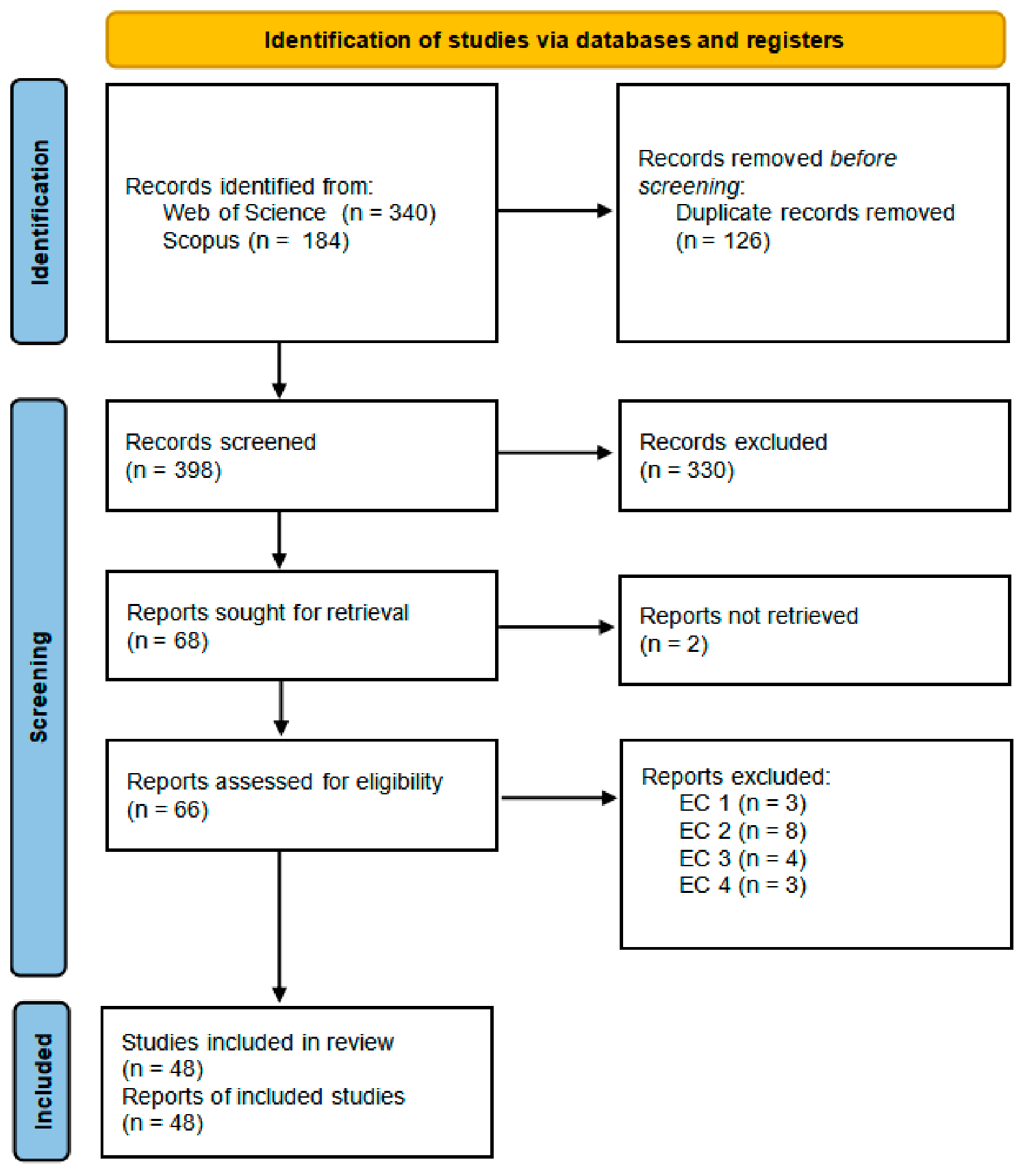
The database searching yielded a total of 524 records, including 340 from Web of Science Core Collection and 184 from Scopus. After the removal of 126 duplicate records, 398 unique studies remained for title and abstract screening. Among these, 330 records were excluded based on the predefined inclusion and exclusion criteria. The full texts of 66 articles were then assessed for eligibility. In total, 18 articles were excluded due to irrelevance to RPV potential assessment, lack of AI-based methodologies, or insufficient methodological details. Ultimately, 48 studies were included in this scoping review. The study selection process is illustrated in the PRISMA-ScR flow diagram (
Figure 1), which demonstrates a substantial reduction from initial retrieval to final inclusion, reflecting the specificity of AI-based urban RPV potential assessment as a research domain.
3.2. General Characteristics of the Included Studies
3.2.1. Geographic Distribution
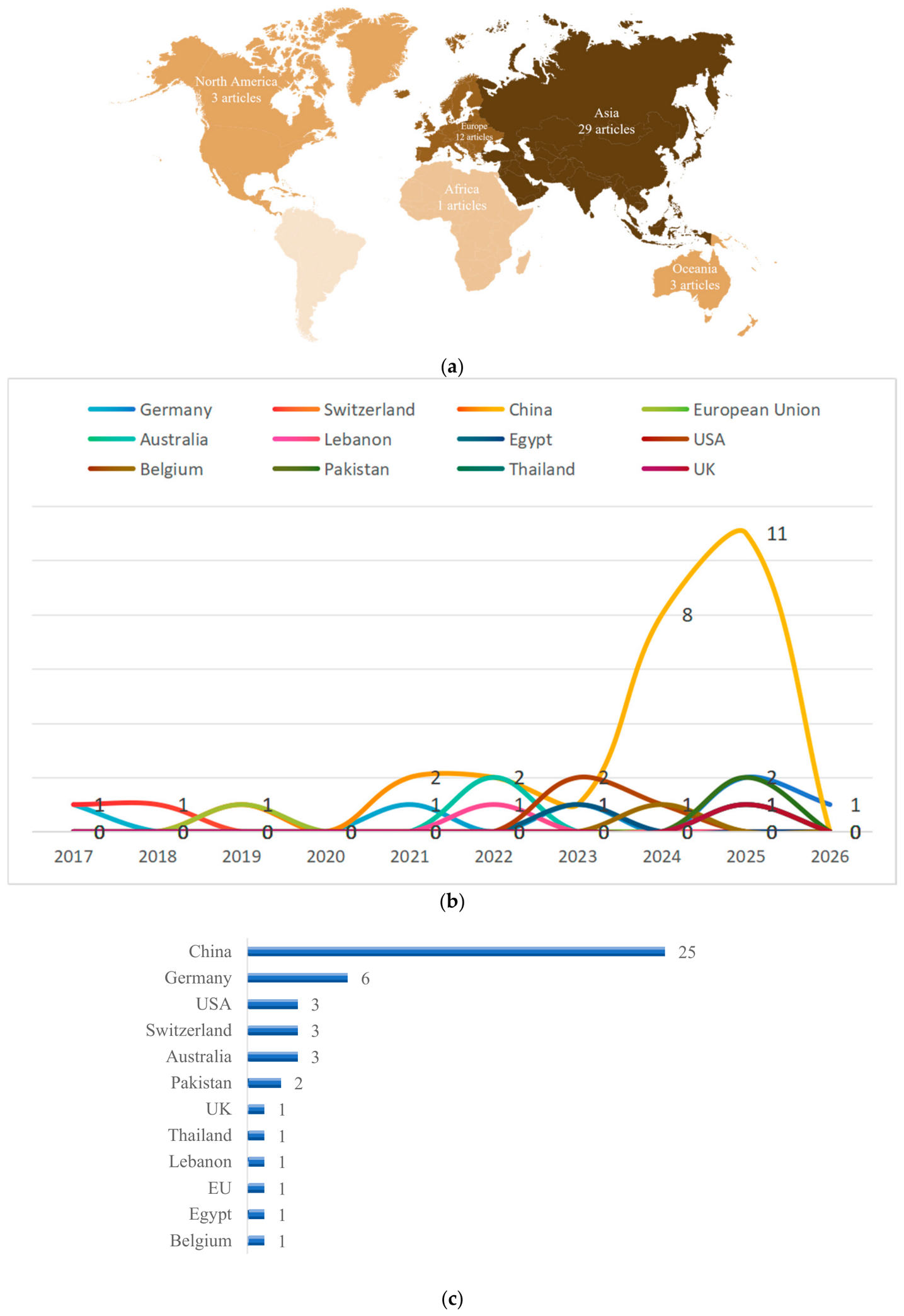
The 48 included studies are distributed across 12 countries and regions spanning five continents (
Figure 2a), revealing a highly uneven global research landscape. Asia dominates the field with 29 studies (60.4%), followed by Europe with 12 studies (25.0%). North America and Oceania each contributes 3 studies (6.3%), while Africa is represented by only one study (2.1%). No eligible studies were identified from South America. This distribution shows a clear geographic imbalance, with research activities concentrated in a limited number of regions rather than evenly distributed across global urban contexts. The temporal evolution of publications (
Figure 2b) reveals a clear shift in geographic dominance over time. Early studies (2017–2019) were mainly led by Europe, showing its early advantage in geospatial infrastructure. Publications from China increased rapidly after 2020, with a pronounced surge during 2023–2025, indicating a marked eastward shift in research leadership.
At the national scale (
Figure 2c), China alone contributes 25 studies, accounting for more than half of the total include publications. It reflects the research and policy focus on renewable energy deployment in China. At a finer scale, studies are further concentrated in a small number of metropolitan areas. Among the 25 studies conducted in China, Wuhan (7 studies) and Shanghai (4 studies) are the most frequently investigated cities. Similar patterns are observed in Europe, where research focuses on major cities such as Munich, Zurich, and London. Study areas are selectively chosen, driven by the availability of high-resolution geospatial datasets further reinforce this concentration.
3.2.2. Temporal Evolution
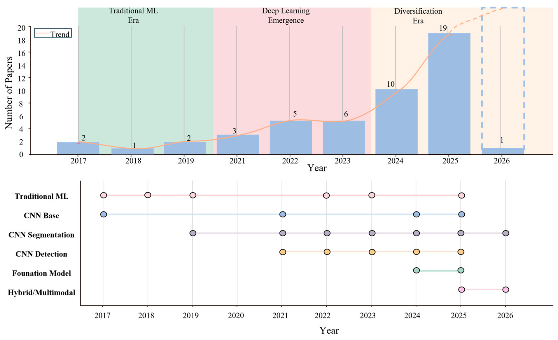
The 48 studies were published between 2017 and 2026, reflecting a growing research interest in AI-based RPV potential assessment (
Figure 3). Beyond the increase in publication volume, the temporal distribution reveals a clear shift in methodological paradigms. During the early stage (2017–2019), only a small number of studies were identified, primarily relying on Conventional ML approaches such as RF and SVM for regression-based potential estimation [
36,
37]. At this stage, feature engineering remained central, and modelling workflows were largely dependent on manually derived variables, limiting automation and scalability. A transitional phase emerged between 2020 and 2023, characterized by the increasing adoption of DL methods. CNN, particular encoder–decoder architectures such as U-Net, became widely used for rooftop extraction from high-resolution imagery [
27,
38,
39,
40]. This transition reflects a broader methodological shift toward data-driven feature learning and improved scalability in geospatial analysis. Since 2024, the field has entered a phase of rapid expansion and diversification, with a sharp increase in publication volume. The year 2025 recorded the highest number of studies (19 studies), followed by 2024 (10 studies). Advanced architectures, including transformer-based models such as SAM, have been increasingly adopted [
29,
41]. This trend demonstrates a movement toward more generalized and transferable modelling approaches.
3.2.3. Cluster and Co-Occurrence Analysis
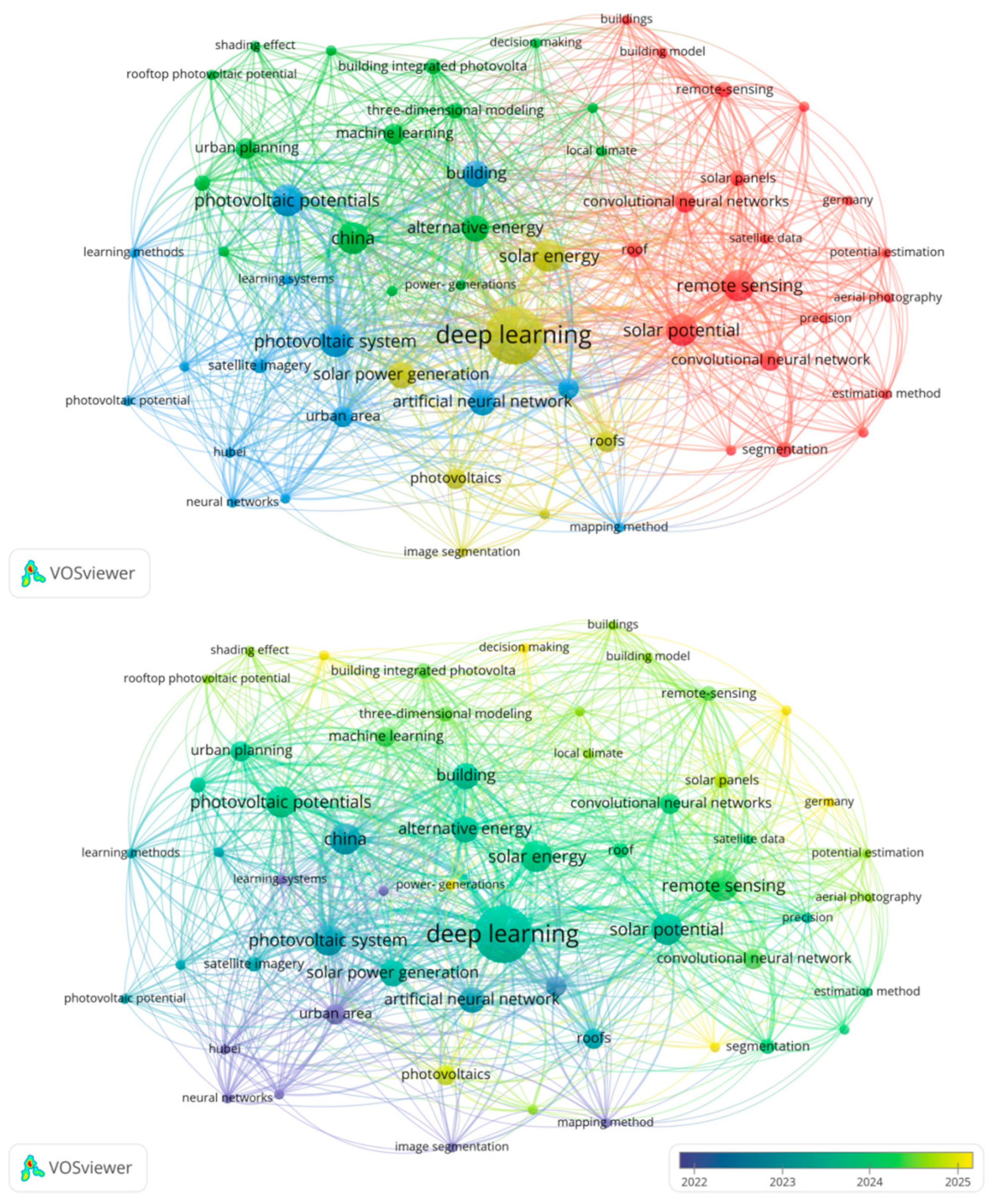
To explore the conceptual structure of AI-based RPV potential assessment research, a keyword co-occurrence analysis (
Figure 4) was conducted based on the included studies. The resulting network reveals a structured yet highly interconnected knowledge landscape, linking data sources, methodological approaches, and application objectives. Several prominent clusters can be identified, corresponding to the core analytical dimensions of the field. A major cluster is centered on image-based rooftop extraction, characterized by high-frequency keywords such as “semantic segmentation”, “deep learning”, and “high-resolution imagery”. This cluster highlights the foundational role of computer vision techniques in enabling automated rooftop identification. A second cluster is associated with energy estimation and regression modelling, including terms such as “solar potential”, “photovoltaic yield”, and “machine learning”. This cluster reflects the quantitative evaluation stage, where extracted geometric and environmental features are translated into energy outputs. A third cluster relates to urban-scale applications and planning contexts, characterized by keywords such as “urban analysis”, “GIS” and “sustainability”, indicating the integration of RPV potential assessment into broader urban and planning contexts. In addition to these thematic groupings, strong co-occurrence relationships are observed between segmentation-related and estimation-related terms, which suggests that these components are frequently combined within unified analytical workflows rather than treated as independent processes.
To further explore how these themes evolve over time, a temporal overlay was applied to the co-occurrence network. It further reveals a clear shift in research focus. Earlier studies are more closely associated with keywords such as “image segmentation”, “mapping methods”, and “conventional neural networks”, indicating an initial emphasis on rooftop identification and spatial data processing. In contrast, more recent keywords, including “solar potential”, “estimation method”, and “precision”, are increasingly concentrated around “deep learning” and “remote sensing”, which reflects a growing emphasis on quantitative evaluation and performance-oriented modelling. Moreover, the increasing co-occurrence of segmentation-related and estimation-related terms in recent periods shows a tendency toward tighter integration between geometric extraction and energy assessment within the same analytical frameworks.
Overall, the combined structural and temporal patterns indicate a transition from predominantly extraction-oriented approaches toward more integrated RPV potential assessment workflows, while the relative prominence of different components remains uneven across the literature.
3.2.4. Spatial Scale
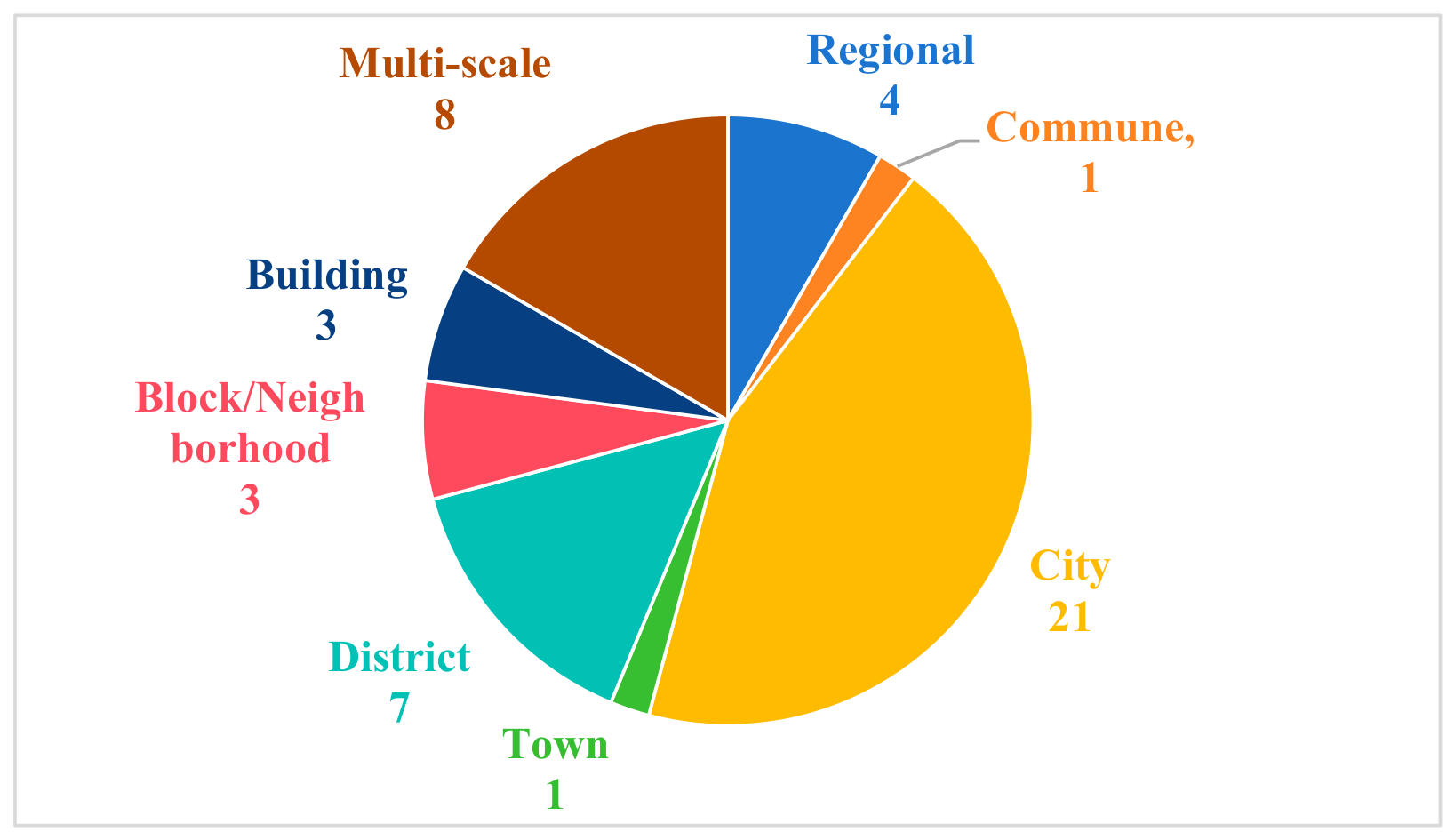
The reviewed studies were conducted across multiple spatial scales (
Figure 5), city-level analyses were the most prevalent (21 studies, 43.8%), accounting for the largest proportion of the sample. District-level assessments were identified in 7 studies (14.6%), while regional-scale analyses were reported in 4 studies (8.3%). Multi-scale approaches were adopted in 8 studies (16.7%), reflecting increasing efforts to integrate modelling across hierarchical spatial levels. Finer spatial resolutions were comparatively less common. Block or neighbourhood-level and individual building-level studies were each represented by 3 publications (6.3%), while 1 study focused on the commune scale (2.1%) and 1 on the town scale (2.1%). This distribution indicates a clear imbalance toward larger spatial scales, with relatively limited attention given to small-scale architectural modelling.
The dominance of city-level assessments suggests that most AI-based RPV studies are oriented toward supporting urban-scale energy planning, policy evaluation, and large-scale resource mapping, rather than detailed building-specific optimization [
42,
43,
44,
45]. Building and neighbourhood level studies require more precise geometric and environmental modelling, including detailed roof structures, shading interactions, and local microclimatic conditions [
31,
46]. Such analyses are often constrained by the availability of high-resolution data, such as aerial imagery or LiDAR, as well as increased computational demands [
27]. As a result, fine-scale studies remain relatively limited despite their importance for design-level decision-making and implementation.
Importantly, the choice of spatial scale is closely linked to methodological design. Large-scale, like city or regional level studies tend to rely on DL-based segmentation models for rapid rooftop extraction and employ simplified assumptions in subsequent estimation stages [
40,
43,
47,
48]. In contrast, small-scale studies more frequently integrate detailed geometric modelling, physical simulation, or hybrid AI approaches to improve accuracy [
31,
46]. This reflects a fundamental trade-off between scalability and physical realism in AI-based RPV potential assessment. The emergence of multi-scale frameworks further highlights a growing research trend toward bridging these scales. By combining large-scale rooftop detection with localized performance modelling, such approaches aim to connect fine-grained geometric information with broader urban energy system analysis [
49,
50]. This demonstrates a shift from isolated, single-scale studies toward more integrated, hierarchical modelling strategies capable of supporting both planning-level and design-level applications.
3.2.5. Input Data
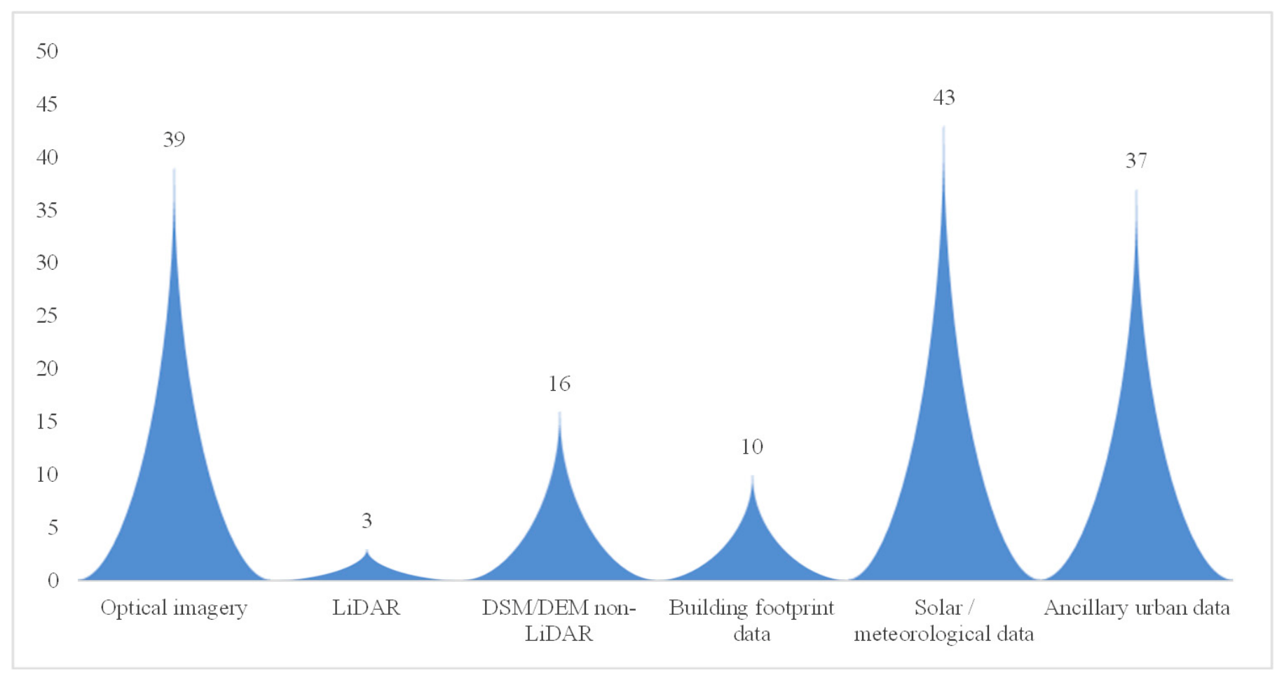
AI-based RPV potential assessment relies on diverse input data sources (
Figure 6), reflecting the multi-dimensional nature of RPV potential modelling. Energy estimation remains fundamentally dependent on physics-related variables, even when AI methods are employed. Solar and meteorological data were the most frequently used input sources, appearing in 43 studies (89.58%). Optical imagery is the second most frequently used data source (39 studies, 81.25%), highlighting the central role of image-based rooftop identification in current workflows. Many studies extend beyond technical potential estimation toward broader urban analysis. As a result, ancillary urban data, including land use [
29,
51], population density, and Local Climate Zone (LCZ) classification [
49,
50], are also widely incorporated (77.08%). In contrast, elevation-related datasets are less consistently used. DSM/DEM data appear in 16 studies, while LiDAR data are used in only 3 studies. The adoption of high-precision 3D data is limited. Building footprint datasets are incorporated in 10 studies, suggesting that many approaches rely on image-based reconstruction rather than authoritative datasets.
Overall, the reviewed studies reveal a rapid development and an uneven research distribution in AI-based urban RPV potential assessment, with most studies concentrated in data-rich metropolitan areas. At the same time, the temporal evolution and keyword co-occurrence analysis indicate a progressive transition from isolated rooftop extraction tasks toward more integrated and automated assessment workflows. The diversity of input data also indicates that current approaches are gradually combining remote sensing, geospatial, and environmental information within the analytical processes. These findings suggest that the differences among studies are not only reflected in the AI methods employed, but more importantly in how AI is integrated into the overall assessment workflow. Therefore, the following section further examines the workflow patterns of AI-based urban RPV potential assessment.
3.3. Workflow Patterns in AI-Based RPV Potential Assessment
Building upon the general characteristics identified in
Section 3.2, this section examines how AI techniques are applied within urban RPV potential assessment process. Based on the workflow taxonomy proposed in
Section 2.3.2, the reviewed studies were categorized into geometry-based workflows, parameter-based workflows, end-to-end estimation workflows, and hybrid workflows. These workflow paradigms reflect different ways of representing and processing urban information for RPV potential assessment.
Table 1 summarises the major methodological characteristics and differences among the identified workflow paradigms.
Among the reviewed studies, geometry-based workflows were the most prevalent workflow paradigm (35 studies), followed by parameter-based workflows (9 studies). In contrast, only a limited number of studies were classified as end-to-end estimation workflows (1 study) or hybrid workflows (3 studies). This distribution shows that current AI-based urban RPV potential assessment mainly relies on geometric reconstruction of the built environment. Parameter-based workflows represent a secondary methodological direction based on simplified urban indicators and statistical representations. End-to-end and hybrid workflows currently remain exploratory approaches within the literature.
It should be noted that workflow paradigms and AI tasks represent different analytical dimensions in this review. Workflow paradigms describe the overall organization of the assessment process, whereas AI tasks refer to specific technical operations performed within different workflow stages, categorized as segmentation, detection, classification, regression and prediction, and reconstruction. Consequently, a single workflow paradigm may involve multiple AI tasks, while the same AI task may appear across different workflow paradigms. The following subsections comparatively analyse the methodological characteristics of each workflow paradigm, focusing on their dominant modelling logic, the AI tasks involved, and the evolving role of AI in urban RPV potential assessment.
3.3.1. Geometry-Based Workflow
Geometry-based workflows constitute the dominant methodological paradigm in current urban RPV potential assessment research. Most geometry-based workflows are organized as sequential estimation process involving rooftop extraction, geometric feature derivation and RPV potential estimation [
41,
52]. In these workflows, AI is primarily employed to derive explicit geometric representations of rooftop geometry and urban form [
53,
54], while downstream estimation generally relies on GIS-based analysis [
47], solar radiation simulation [
51], and physically based estimation processes [
27]. Common geometric representations include rooftop segmentation masks, rooftop superstructures, and three-dimensional building forms. Accordingly, geometry-based workflows are strongly associated with computer vision related AI tasks, particularly segmentation, reconstruction, detection, and classification tasks that support rooftop extraction and geometric interpretation. Beyond simple boundary delineation, extracted rooftop representations are commonly used to analyse rooftop geometry [
55], usable installation area [
56], rooftop superstructures [
44], and shading relationships [
33]. As a result, the accuracy of RPV estimation in these workflows largely depends on the quality of geometric inference during the spatial extraction stage.
Segmentation remains the dominant AI task in geometry-based workflows and is predominantly implemented using encoder–decoder DL architectures to extract rooftop geometry from urban imagery. U-Net and its variants are the most widely adopted [
39,
57,
58,
59,
60,
61], due to their ability to preserve spatial detail and improve boundary accuracy. DeepLab v3 is also widely adopted to capture multi-scale contextual information in heterogeneous urban environments [
42,
56], while transformer-based architectures [
30,
52] and foundation models such as SAM [
29,
41] further enhance the capability to capture complex rooftop morphology and irregular urban structures. To improve model generalisability across cities, Chen et al. [
51] incorporated transfer learning and domain adaptation strategies to reduce performance degradation under varying urban conditions. In parallel, multi-task learning frameworks combining segmentation with related objectives such as classification or boundary detection have also emerged to improve robustness across diverse rooftop typologies [
43,
44,
62]. These developments indicate an ongoing methodological transition from isolated rooftop extraction toward more generalised urban spatial understanding. Several studies further integrated classification tasks together with segmentation to refine rooftop suitability analysis and spatial extraction results. Mainzer et al. [
25] combined CNN-based binary classification of RPV presence with rooftop and obstacle segmentation to estimate effective installation area under shading and obstruction constraints. Similarly, Zhang et al. [
28] integrated VGG16-based urban land-use classification with U-Net rooftop segmentation to differentiate rooftop suitability across heterogeneous urban functional zones. Muhammed et al. [
63] further combined mean-shift and k-means segmentation with SVM and Naïve Bayes classification to distinguish rooftop and non-rooftop regions from satellite imagery. Therefore, classification tasks within geometry-based workflows mainly support geometric extraction and contextual rooftop interpretation rather than replacing explicit rooftop reconstruction itself.
Other than segmentation tasks, AI techniques are also used for detection tasks in geometry-based workflows. The detection task is used for rapid localization of RPV systems or rooftop structures without reconstructing detailed rooftop geometry. Reference [
64] employed a Single-Shot Detector (SSD) with a ResNet34 backbone to identify RPV installations from aerial imagery through bounding-box prediction. Compared with pixel-level segmentation, detection tasks provide computationally efficient and are therefore suitable for large-scale PV mapping and monitoring applications. Beyond two-dimensional rooftop delineation, recent studies further integrated reconstruction tasks to recover rooftop orientation, slope, and three-dimensional shading relationships for physically based solar radiation modelling. These reconstruction workflows commonly combine imagery with DSM or LiDAR data to obtain more accurate three-dimensional rooftop geometry and shading information. Reference [
29] combined SAM-based rooftop segmentation with DSM and land use/land cover (LULC) data to reconstruct rooftop geometry and support rooftop height estimation, shadow simulation, and effective rooftop area calculation. Similarly, reference [
33] used a multi-modal CNN to reconstruct 3D building forms from LiDAR point clouds and aerial imagery. Compared with two-dimensional rooftop extraction alone, reconstruction tasks provide stronger capability for modelling inter-building shading interactions and complex urban morphology, thereby improving the physical realism of downstream RPV potential assessment.
A major advantage of geometry-based workflows is their relatively high interpretability because rooftop geometry and urban morphology remain explicitly represented throughout the estimation process [
65,
66], which makes it particularly suitable for planning-oriented applications requiring spatial transparency and explainable estimation processes [
25]. However, error propagation between stages can significantly degrade overall performance. Several studies reported that geometric uncertainty may exhibit non-linear amplification effects in later estimation stages, particularly in dense urban environments characterised by complex roof structures and dynamic shading interactions. Krapf et al. [
27] showed that inaccurate rooftop slope estimation from aerial imagery can introduce substantial downstream error. When estimating a roof slope of 70° instead of the reference value of 37°, it led to more than 125% relative error in rooftop area estimation [
27]. Ren et al. [
39] found that modelling shading effects and rooftop availability reductions separately can overestimate the total reduction by up to 26% due to non-linear interaction effects. Chen et al. [
67] observed that each 1% increase in rooftop segmentation Mean Percentage Error (MPE) may lead to approximately 0.5–1.5% additional relative error in final RPV potential estimation results due to the cumulative effect of area calculation errors. Consequently, geometry-based workflows are highly dependent on the quality of geometric inference. Errors introduced during segmentation and reconstruction can be amplified throughout downstream RPV estimation processes. The reviewed studies mainly quantified such propagation effects through two approaches. Some studies adopted sensitivity-based analysis to examine the relationship between geometric extraction accuracy and downstream estimation error. Others employed comparative assessment under different shading, orientation, or rooftop utilisation assumptions.
3.3.2. Parameter-Based Workflow
Parameter-based workflows represent a secondary methodological direction in current urban RPV potential assessment research. Unlike geometry-based workflows, parameter-based workflows estimate RPV potential through engineered urban, environmental, morphological and statistical descriptors rather than explicit rooftop geometric reconstruction. Typical descriptors include irradiance indicators, rooftop area ratios, rooftop orientation and slope statistics, shading coefficients, urban density metrics, Local Climate Zone (LCZ) descriptors, and meteorological variables. These descriptors are subsequently used as inputs for AI-based regression and prediction models to estimate PV installation rates, electricity generation potential, or economic feasibility. References [
31,
46] generated parameterised urban datasets by varying building height, spacing, and urban typology using parametric modelling tools Rhino and Grasshopper.AI models were then applied to predict PV-related outputs based on these urban descriptors and simulated urban conditions.
Regression and prediction are therefore the dominant AI tasks in parameter-based workflows. Conventional ML approaches, including RF [
37,
49], SVM [
36], ANN [
68], and XGBoost [
50], are widely adopted in regression and prediction tasks because of their ability to process structured datasets and capture non-linear relationships among variables. RF models demonstrated strong performance and relatively high interpretability in estimating PV power potential using only a limited number of influential parameters [
49]. Another important characteristic of parameter-based workflows is the use of sensitivity analysis and feature-importance evaluation to identify the urban parameters that most strongly influence PV performance. In [
46], global sensitivity analysis was used to evaluate the relative influence of urban morphological parameters such as building height, building spacing, and neighbouring building obstruction on PV performance, the most influential descriptors were selected as inputs for ML and DL prediction models. Chai et al. [
50] incorporated explainable ML technique SHAP analysis to quantify the relative contributions of urban morphological and environmental variables to solar radiation and PV potential estimation. It indicates an ongoing methodological transition from purely empirical statistical estimation toward more interpretable urban energy modelling frameworks.
In addition to regression and prediction, classification tasks also appear in parameter-based workflows when AI is used to derive contextual urban descriptors. Zhang et al. [
69] applied ResNet-50 and ResNet-101 to classify buildings into residential, industrial-commercial, and public categories using multi-scale satellite imagery, building footprints, and spatial features. The resulting building function labels were then integrated with other urban parameters, such as rooftop area and irradiance conditions, to support differentiated PV potential estimation across building types. This means that the classification task serves as a descriptor generation step for downstream prediction. Beyond this study, DL methods have been increasingly used in parameter-based workflows to capture complex relationships among multiple urban parameters used together in the models [
31,
46]. CNN-based approaches were capable of automatically extracting latent spatial features associated with building density, height variation, and shadow interactions, thereby improving predictive accuracy compared with conventional ML approaches [
31].
Compared with geometry-based workflows, parameter-based approaches generally require lower computational resources because detailed rooftop reconstruction and physically intensive geometric simulation are avoided throughout the estimation process. This computational efficiency makes parameter-based workflows particularly suitable for rapid large-scale assessment [
70], urban energy benchmarking [
68], scenario comparison during early-stage urban design [
46], and regional screening applications where detailed rooftop geometry is unavailable or computationally impractical [
46,
70]. Furthermore, parameter-based representations can be readily integrated with planning indicators, socio-economic variables, and climate datasets, thereby facilitating cross-city comparative analysis and regional energy planning [
69]. However, parameter-based workflows generally exhibit weaker physical realism and lower spatial interpretability than geometry-based approaches because rooftop geometry, rooftop superstructures, and explicit inter-building shading relationships are not directly represented during the estimation process. Reference [
68] noted that simplified descriptors such as plot ratio, building density, and sky view factor may inadequately capture complex rooftop morphology and heterogeneous urban environments. Similarly, Tand et al. [
49] highlighted that LCZ-based parameter frameworks lack explicit 3D building models and detailed rooftop geometry, limiting the representation of building-specific solar insolation conditions. In addition, the predictive performance of parameter-based workflows is highly dependent on the representativeness and transferability of engineered descriptors and training datasets. Reference [
70] noted that correction coefficients derived from reference datasets may not generalise well across cities or climatic regions with different urban morphology, while [
69] showed that uniform rooftop availability coefficients and system-efficiency assumptions may introduce simplification errors across different building functions. Assouline et al. [
36] further demonstrated that errors introduced during parameter abstraction, such as predicted slope distributions and shading coefficients, may propagate into downstream PV estimation across different spatial scales.
3.3.3. End-to-End Estimation and Hybrid Workflows
While geometry-based and parameter-based workflows represent the two dominant methodological paradigms in RPV potential assessment, several studies exhibited characteristics that extend beyond these categories. Additional workflow paradigms were identified as end-to-end estimation workflows and hybrid workflows. Although these approaches remain less common than geometry-based and parameter-based workflows, they illustrate additional directions in AI-based RPV potential assessment.
End-to-End Estimation Workflow
End-to-end workflows represent a fully data-driven estimation paradigm in which multiple estimation tasks are implicitly integrated within a single AI model. They directly predict RPV potential from raw urban input data without generating explicit intermediate representations such as rooftop masks, building geometries, or radiation maps. Geng et al. [
71] provided the clearest example of an end-to-end estimation workflow which developed a multi-channel one-dimensional CNN model to directly estimate annual BIPV potential from urban point cloud data. Instead of explicitly extracting morphological parameters or constructing intermediate geometric representations prior to estimation, the CNN directly learned the relationship between raw point cloud inputs and RPV potential. The proposed model achieved a coefficient of determination (R
2) value of 0.937 and substantially outperformed conventional multiple linear regression models (R
2 = 0.769). This demonstrates the ability of end-to-end learning to capture complex non-linear relationships between urban morphology and RPV potential without explicit intermediate modelling stages.
The main advantage of end-to-end estimation workflows lies in their high degree of automation, reduced preprocessing requirements, and ability to minimise cumulative error propagation across sequential estimation stages. However, this simplification also reduces interpretability. Since intermediate geometric or physical outputs are absent, it becomes more difficult to explain model behaviour, diagnose prediction errors, or trace how specific urban morphological characteristics influence final predictions. End-to-end workflows also generally require larger quantities of labelled training data because the model must simultaneously learn both feature representations and prediction relationships that are explicitly encoded in geometry-based workflows. Furthermore, the absence of explicit geometric outputs may limit their applicability in downstream planning tasks requiring rooftop-level spatial information, such as panel placement optimisation, shading analysis, or grid integration studies [
71].
Hybrid Workflow
Hybrid workflows jointly employ multiple estimation paradigms within the same RPV potential assessment process. Unlike geometry-based or parameter-based workflows, hybrid workflows integrate combinations of geometric representations, engineered parameters, and physically based simulation components during the estimation process. In practice, hybrid workflow most commonly couple AI-based prediction models with physically or geometrically grounded estimation procedures, enabling data-driven learning and physically constrained modelling to jointly contribute to PV potential assessment. Lei et al. [
72] combined physically based solar radiation simulation in Ladybug Tools with an NSGA-II-ANN model to capture the non-linear relationships between PV panel configurations and multi-dimensional performance indicators, achieving high predictive accuracy (R
2 > 0.96) while reducing the computational burden of the optimisation process. Similarly, Yang et al. [
32] integrated geometrically derived shading relationships, which were computed from building height differences, solar altitude angles, and shadow projection distances, into a GCN-LSTM framework to model spatiotemporal dependencies in RPV prediction. This approach improved accuracy over conventional LSTM models by reducing MAE and MSE by 21% and 22% respectively, particularly under strong seasonal shading conditions. Hybrid workflows also include sequential modelling pipelines that separate physical extraction from statistical inference. Kim et al. [
73] proposed a two-stage framework in which a CNN-based object detection model first extracted spatially explicit rooftop and PV information from satellite imagery, producing deployment indicators such as PV counts and PV-to-roof ratios, which were then used as inputs for ensemble ML models including XGBoost and RF to analyse spatial variation in PV adoption and its driving factors. This design reflects a hybrid logic that integrates physics-grounded spatial measurement with data-driven explanatory modelling within a unified assessment pipeline.
Hybrid workflows combine multiple workflow paradigms within a unified estimation pipeline, enabling physically or geometrically based components and machine learning models to jointly contribute to RPV potential assessment, and improving predictive performance through the incorporation of domain knowledge into AI models. At the same time, AI techniques can reduce the computational burden associated with simulation or optimisation intensive procedures by approximating complex non-linear relationships within the estimation pipeline, thereby improving scalability for large-scale urban applications [
72]. However, hybrid workflows also introduce several limitations, including increased methodological complexity due to multi-component system design, residual error propagation across coupled stages, and dependence on sufficient training data and calibration. In addition, their performance may be constrained by mismatches in spatial or temporal resolution between heterogeneous data sources and reduced transferability across different geographic and climatic contexts without retraining or recalibration [
32,
73].
Overall, the reviewed studies demonstrate an increasing diversification of AI-based methodological strategies in urban RPV potential assessment. Geometry-based workflows remain the dominant approach in the reviewed studies, while parameter-based, end-to-end, and hybrid workflows provide alternative strategies under different data availability, computational, and application conditions. The reviewed studies also reveal several persistent challenges related to geometric uncertainty, model interpretability, data dependency, transferability, and multi-source integration across different urban contexts. These issues highlight the need for more robust and generalisable AI-based RPV potential assessment frameworks, which are further discussed in the following section.
4. Discussion
The comparative synthesis of the reviewed studies reveals that AI-based urban RPV potential assessment has evolved from isolated estimation tasks toward increasingly integrated and workflow-oriented assessment frameworks. Despite the rapid methodological development and growing workflow sophistication, several unresolved challenges remain regarding scalability, interpretability, transferability, physical realism, and urban applicability. Therefore, the following sections further discuss the major methodological limitations, emerging research trends, and future development directions of AI-integrated urban RPV assessment workflows.
4.1. Current Challenges in AI-Based Urban RPV Potential Assessment
Current AI-based urban RPV potential assessment still involves several unresolved methodological challenges. One major challenge is balancing estimation efficiency with physical interpretability, particularly under heterogeneous urban conditions. Different workflow paradigms emphasize different combinations of physical realism, scalability, automation, interpretability, and transferability. Geometry-based workflows are generally more transparent and physically interpretable, but their dependence on detailed geometry and computationally intensive simulation often limits scalability in dense and complex urban environments. This limitation becomes particularly evident in high-density urban environments involving dynamic shading interactions. Traditional ray-tracing and physically based solar simulation methods can achieve high physical fidelity in representing complex shading behaviour, but their computational cost often restricts large-scale implementation [
74]. AI-based surrogate models substantially improve estimation efficiency by approximating shading relationships from urban morphology and remote sensing features. However, this acceleration may introduce reduced physical interpretability and potential accuracy degradation under highly heterogeneous or temporally dynamic urban conditions. In contrast, parameter-based and end-to-end workflows improve computational efficiency and large-scale applicability by simplifying or bypassing explicit geometric representation, but often reduce physical transparency and weaken the representation of complex shading interactions. This trade-off is particularly important in planning-oriented applications. Urban planners and policy-makers require not only prediction accuracy, but also interpretable reasoning regarding how rooftop morphology, urban density, shading conditions, and environmental factors influence RPV estimation results. Limited explainability may reduce the practical applicability of AI-based assessment results in real-world planning processes [
75]. In urban planning and policy-making, decision-makers often require transparent reasoning to justify investment priorities, zoning strategies, subsidy allocation, and infrastructure deployment. Black-box prediction models may therefore create difficulties in communicating assessment uncertainty, validating planning assumptions, and building stakeholder trust, particularly when estimation outcomes influence long-term urban energy policy and public resource allocation. In addition, insufficient interpretability may hinder the integration of AI-based RPV assessment into broader urban governance frameworks that require accountability, transparency, and spatially explicit decision support. Consequently, improving explainability is not only a technical challenge, but also an important prerequisite for practical planning implementation and policy acceptance. Consequently, current methodological development continues to balance scalable estimation against the need for spatially explicit and physically interpretable assessment processes.
Transferability represents another major methodological challenge. The geographic concentration identified in
Section 3.2.1. reflects not only an uneven distribution of study locations, but also the strong dependence on data availability. Most studies are conducted in data-rich metropolitan areas, where high-resolution imagery, LiDAR datasets, and detailed urban information are readily accessible. This indicates that methodological development in the field is not solely driven by algorithmic innovation, but is closely conditioned by the availability, resolution, and heterogeneity of underlying data sources [
76]. When applied to different cities or regions, these models often experience significant performance degradation due to domain shift [
77]. This shift includes variations in urban morphology and differences in data resolution, as well as environmental and climatic conditions that affect rooftop appearance and shading patterns. As a result, features learned under one set of conditions may not transfer effectively to another, leading to reduced accuracy in rooftop extraction, suitability classification, and energy estimation. To address these issues, increasing attention has been given to domain adaptation and transfer learning strategies that aim to improve cross-region applicability under heterogeneous urban conditions [
78]. Transfer learning allows models pretrained in data-rich metropolitan environments to be adapted to data-scarce cities with limited labeled samples, thereby reducing annotation dependence and improving cross-city generalization. Meanwhile, self-supervised learning has emerged as a promising approach for exploiting large volumes of unlabeled remote sensing imagery, LiDAR data, and urban visual data to learn transferable feature representations prior to downstream fine-tuning. Such strategies may improve model robustness under heterogeneous urban conditions and help alleviate the geographic imbalance of annotated datasets [
79]. However, balancing cross-region generalization with region-specific accuracy remains challenging. Models optimized for transferability often rely on generalized feature representations that may overlook local rooftop and environmental characteristics, while models calibrated for specific cities may show limited robustness in other urban contexts. This reflects an inherent trade-off between scalability and regional adaptation in current AI-based RPV assessment workflows [
80]. Consequently, the high performance reported in benchmark studies may partly reflect favorable data conditions rather than true model robustness, limiting the applicability of existing methods in data-constrained cities. Nevertheless, continued advances in remote sensing data acquisition, PV technologies, and urban data infrastructure may gradually improve the transferability and adaptability of the workflow frameworks summarized in this review across different climatic and urban environments.
In addition, most existing AI-based RPV potential assessment workflows rely on static assumptions. However, real urban environments continuously evolve through new construction [
81], vegetation growth, seasonal atmospheric variation, changing rooftop conditions, and shifting urban energy demand patterns [
82]. Such temporal dynamics may substantially influence shading interactions, rooftop suitability, and PV performance over time. Current static estimation frameworks may have limited capability for representing long-term urban energy performance under rapidly changing urban conditions. This challenge highlights the importance of future research on adaptive assessment frameworks capable of continuously integrating evolving urban and environmental information. Beyond urban environmental dynamics, most existing AI-based urban RPV assessment workflows still simplify PV performance as fixed conversion parameters [
25], despite actual PV efficiency being highly dynamic and environmentally sensitive. This simplification may limit the physical realism of long-term urban PV estimation. In practice, PV performance is influenced by multiple factors, including solar radiation conditions such as global horizontal irradiance (GHI) and diffuse horizontal irradiance (DHI), meteorological conditions such as global irradiance, ambient temperature, and relative humidity, atmospheric conditions including cloud cover, environmental pollutants such as dust accumulation and sandstorms, as well as the intrinsic characteristics of photovoltaic technologies themselves [
83]. These factors may substantially alter PV electricity generation under heterogeneous urban conditions, yet they remain insufficiently represented in many current AI-based estimation workflows. In addition, PV efficiency continuously changes over time due to environmental exposure and material ageing. PV efficiency degradation was reported [
84] to result from multiple environmental and ageing factors, including dust accumulation, discoloration, microcracks, delamination, high temperature, and humidity. Reported degradation rates [
84] commonly ranged 0.6–0.7% annually, but could reach 1.5–4.9% per year under harsh climatic conditions, while silicon-based PV efficiency typically decreased by 0.03–0.05% for every 1 °C temperature increase. Reference [
49] further demonstrated that urban heat island (UHI) effects may significantly reduce urban BIPV efficiency, suggesting that urban PV assessments neglecting climate-sensitive performance variation may overestimate long-term photovoltaic potential. At the same time, PV technologies have continuously evolved over recent decades. Commercial PV efficiencies have increased from slightly above 10% in early crystalline silicon systems to around 22% in current mainstream commercial modules, while some advanced technologies already exceed 25%. Driven by improvements in cell architecture, manufacturing processes, and emerging materials such as perovskite-silicon tandem cells, these technological advances may further influence long-term urban PV generation capacity, economic feasibility, and future energy planning assumptions [
85]. These findings indicate that current AI-based urban RPV assessment workflows still face important limitations in representing environmentally sensitive PV performance. As a result, simplified efficiency assumptions may introduce substantial uncertainty into long-term urban PV potential estimation, particularly under evolving climatic, environmental, and technological conditions.
4.2. Future Directions
4.2.1. Multimodal and Physics-Informed AI
Early Conventional ML approaches primarily relied on handcrafted features and structured inputs, while later DL methods enabled automated feature extraction from high-resolution imagery and urban sensing data. More recent developments further extend this transition toward multimodal learning frameworks [
33] that combine imagery, LiDAR, GIS layers, meteorological information, urban morphology, and socio-economic datasets within unified models [
77]. However, integrating heterogeneous urban datasets also introduces important methodological challenges, particularly regarding spatial registration and feature-scale mismatch between raster-based optical imagery and irregular LiDAR point clouds. Existing studies generally address these issues through coordinate alignment, spatial resampling, and multi-scale feature learning strategies, although robust cross-modal fusion under heterogeneous urban conditions remains an important unresolved challenge [
86]. This transition reflects the increasing need to represent urban RPV systems as part of more complex urban energy environments rather than isolated rooftop estimation tasks. Urban RPV performance is jointly influenced by multiple factors, making conventional estimation increasingly insufficient for representing heterogeneous urban conditions. Multimodal learning therefore represents not only a technical improvement in prediction performance, but also a shift toward more comprehensive urban energy modelling frameworks. Building on this trend of increasingly integrated data representations, recent studies have begun to explore more unified modelling paradigms. Emerging studies involving foundation-model-based urban representation learning and large-scale multimodal reasoning frameworks further suggest a possible transition from narrowly specialized prediction models toward more adaptive urban energy intelligence systems. Rather than focusing solely on numerical prediction, these approaches increasingly attempt to integrate semantic, climatic, regulatory, and spatial information within unified modelling frameworks. Although still at an early stage, this direction suggests that future AI-based RPV potential assessment may gradually evolve beyond conventional prediction tasks toward more context-aware urban energy analysis and decision-support systems.
At the same time, the reviewed studies indicate that purely data-driven prediction is unlikely to fully replace physically constrained modelling in urban RPV potential assessment. Urban RPV potential estimation remains fundamentally governed by physical processes, including solar geometry, radiation transfer, atmospheric conditions, and dynamic shading interactions. Without sufficient physical constraints, purely data-driven optimisation may produce physically inconsistent predictions that conflict with fundamental solar geometry, irradiance relationships, or thermodynamic behaviour. This issue becomes particularly important in hybrid AI workflows, where maintaining consistency between learned representations and physical processes remains a key methodological challenge. Consequently, physically informed AI frameworks are increasingly emerging as an important methodological direction. Recent developments in physics-informed neural networks (PINNs) further illustrate this trend by embedding physical constraints directly into the learning process in order to improve physical consistency and model robustness under heterogeneous urban and climatic conditions [
87,
88]. More broadly, future methodological development is likely to rely on a closer integration between AI models and physically based urban energy simulation. Such integration may also improve model interpretability and generalizability, particularly in data-constrained urban environments where purely data-driven approaches often struggle to maintain stable performance.
Another important future direction is the integration of AI-based RPV potential assessment with urban digital twin technologies. Digital twins provide dynamic virtual representations of urban environments through the continuous integration of sensing data, urban geometry, infrastructure information, and environmental conditions. Coupling AI-based RPV potential assessment with digital twin systems may enable continuously updated and adaptive urban energy estimation frameworks [
89]. Compared with static assessment workflows, the assessment framework integrated with digital twin can support real-time PV monitoring, adaptive electricity generation prediction, dynamic shading simulation, and scenario-based urban energy planning. More importantly, such frameworks may facilitate tighter integration between RPV, smart grids, energy storage systems, and urban carbon-neutrality strategies. The role of AI in urban RPV potential assessment may therefore gradually extend toward adaptive urban energy management and decision-support systems [
90]. However, these types of assessment frameworks remain constrained by high computational requirements, continuous data updating, and the availability of real-time sensing infrastructure. Future research may therefore need to balance real-time adaptability with computational feasibility and data accessibility under different urban conditions.
4.2.2. Beyond Rooftops
Beyond methodological developments, the application scope of AI-based RPV potential assessment is also expanding beyond conventional rooftops. Building façades, particularly in high-density urban areas provide additional PV deployment surfaces beyond rooftop space [
91]. Biosolar roofs combine green roofs with PV systems, may improve PV operating conditions through evaporative cooling while simultaneously providing ecological benefits such as thermal regulation and stormwater management [
92]. Parking canopies and other large open urban surfaces can support large-scale PV deployment while enabling multifunctional use of urban space [
93]. Transportation infrastructure, such as elevated roads and noise barriers, may also provide opportunities for PV integration without requiring additional land occupation. In addition, windows, shading devices, and other BIPV components may further expand the applicability of distributed urban PV systems, while simultaneously increasing the need to consider thermal, optical, and architectural constraints within assessment frameworks. Compared with conventional rooftop applications, these emerging scenarios generally involve more heterogeneous geometries, irregular orientations, and stronger interactions with surrounding urban environments [
94]. This complexity increases the difficulty of geometric reconstruction, irradiance estimation, and environmental modelling under dense urban conditions. Geometry-based workflows therefore become more sensitive to errors in geometric reconstruction and orientation estimation under these conditions. End-to-end workflows may offer greater flexibility for adapting to heterogeneous urban surfaces because they bypass intermediate modelling stages. Hybrid workflows that combine AI-driven perception with physically based modelling may therefore provide stronger adaptability for future urban PV applications by balancing scalability, transferability, and physical consistency.
Overall, this expansion reflects a broader transition from isolated rooftop assessment toward more integrated urban-scale photovoltaic systems. Future photovoltaic deployment is unlikely to remain limited to conventional rooftops, but may increasingly involve façades, biosolar roofs, transportation infrastructure, parking systems, and other distributed urban surfaces suitable for photovoltaic integration. Accordingly, AI-based assessment frameworks may gradually evolve from rooftop-specific estimation tools toward more comprehensive urban-scale evaluation frameworks capable of supporting distributed photovoltaic planning under increasingly complex urban environments.
4.3. Limitations and Future Research Directions
Despite providing a comprehensive synthesis of AI-based urban RPV potential assessment, this review has several limitations that should be acknowledged. First, the review scope was limited to peer-reviewed journal articles indexed in Web of Science and Scopus and published in English. As a result, relevant studies published in other languages, conference proceedings, technical reports, or rapidly evolving grey literature may not have been fully captured. This is particularly important in AI-related fields, where methodological developments often emerge faster than formal journal publication cycles. Second, the reviewed studies exhibit substantial differences in datasets, spatial scales, input data sources, evaluation metrics, and modelling objectives. Such variability makes direct comparison of AI model performance difficult and limits the feasibility of standardized quantitative benchmarking across studies. In many cases, reported model accuracy is strongly influenced by local urban morphology, data quality, and task-specific configurations, reducing the transferability of performance comparisons between different studies. Third, this review organizes the literature through a workflow-oriented perspective, which helps clarify the methodological characteristics, advantages, and limitations of different AI-based urban PV assessment approaches. However, future studies may increasingly integrate multiple AI techniques, data sources, and physical modelling strategies within more comprehensive assessment frameworks. This may further expand the methodological diversity of this field in future research. Finally, this review primarily focuses on methodological developments in AI-based urban RPV potential assessment rather than downstream implementation issues such as policy integration, economic feasibility, grid interaction, or long-term operational performance. These aspects may become increasingly important as urban PV systems expand beyond conventional rooftop deployment toward more integrated urban energy infrastructure applications.
5. Conclusions
This study provides a workflow-oriented scoping review of AI-based urban rooftop RPV potential assessment through a comparative synthesis of 48 peer-reviewed studies. The review shows that research in this field has evolved rapidly since 2017, moving from conventional ML approaches based on handcrafted features toward DL, multimodal learning, and more integrated hybrid workflows paradigm. Rather than functioning as isolated technical tools, AI methods are increasingly embedded within broader urban RPV assessment processes. Four major workflow paradigms were identified, namely geometry-based, parameter-based, end-to-end estimation, and hybrid workflows. Each workflow presents different advantages and limitations regarding automation, scalability, interpretability, computational demand, and physical realism. Geometry-based workflows generally provide stronger physical transparency and closer integration with physics-based modelling, but they often rely heavily on detailed urban data and computationally intensive simulations. End-to-end estimation workflows improve automation and efficiency, although their internal decision-making processes are usually less interpretable. Hybrid workflows attempt to combine the strengths of physics-based modelling and AI-driven learning, and recent studies suggest growing interest in improving physical consistency within AI-integrated assessment frameworks.
The review also identifies several unresolved challenges that continue to affect the reliability and broader applicability of current urban RPV potential assessment methods. These include limited model transferability across cities, benchmarking inconsistency caused by heterogeneous datasets and evaluation criteria, uncertainty propagation throughout multi-stage workflows, and strong dependence on high quality urban data. In addition, many existing studies still focus primarily on methodological performance while giving relatively limited attention to practical planning conditions and real urban decision-making contexts. Future research should therefore move beyond improving prediction accuracy alone. More attention is needed on transferable and adaptive modelling frameworks, multimodal urban data integration, physically informed AI approaches, and stronger connections with urban energy systems and planning applications. Expanding future assessment frameworks beyond rooftops toward broader urban surfaces and multidimensional urban energy environments may also become increasingly important for solar-integrated urban development and built-environment decarbonization.