Abstract
Recent literature has highlighted the critical issue of urban land value and cost; properly assessing land use costs, particularly for residential and commercial purposes, is crucial in influencing urban development and investments. Therefore, the objective of this research is to create a model for land pricing that considers the urban street networks and hierarchy; by analyzing the spatial plan of the city using space syntax and evaluating the economic impact on land value, the study aims to identify the factors that influence land prices. Furthermore, the study intends to investigate the correlation between urban spatial networks, street hierarchy, and land price to create a predictive model for urban spatial land pricing. Ultimately, the study has successfully built a model for predicting the price of urban land. The case selected is evaluated and compared in three aspects of the analysis, including the urban axial assessments and urban street width, to find out their impacts on the real estate’s land price in the context of the land use distributions, which are predominantly residential and commercial types of uses. Depth map X8, SPSS, and QGIS 3.16 were used for the study evaluations and assessments. The study found that land prices are influenced by factors such as integration, connectivity, and street width. Commercial zones with good integration and wider roads tend to command higher prices, while narrow local roads generally have lower prices. This result can enhance future urban design regarding urban economy improvements and land costs.
1. Introduction
The urban economy has witnessed an interest in urban studies due to the value problem, especially the problems with land price determinations due to the city’s decentralization, urbanization, and new financial crisis. Another critical characteristic of recent studies on urban morphology is the use of street networks to describe the built environment. Many studies can be found on the relationship between urban street networks and land prices. Still, fewer compare urban street integration and street width with an urban land price, in which urban land use and localized decisions and returns no longer seem appropriate to modern urban planning and design.
Land location and land price problems occur due to urban planning and design based on the availability of different zoning in cities and spatial concepts. Real estate securitization is one of the many aspects that are regulated by law [1]; additionally, unplanned development affects land value, and unregulated development causes land subsidence, damaging infrastructure and lowering property values [2,3,4]; those problems can be solved by arranging an optimal urban structure. An optimal urban system means that it has an optimal integrated and accessible urban, and the only way to assess the level of the integrated street network and identify problems of urban accessibility is through the use of syntactic analysis of the space syntax. The effect of optimal urban structure on land value and price still needs to be obvious; at the same time, spatial configurations create possibilities for economic activity. This should also be viewed as the reverse approach of how urban economics requires proximity in distance to be produced. This relationship has yet to be approached in space syntax research [5]. Therefore, this study examined urban economy and structure based on space syntax analysis to determine the impact of urban street integration on land prices. Space syntax offers a set of techniques to correlate the results from spatial analyses with various socioeconomic data [6]. On the other hand, the study investigates the impact of street hierarchy, including street width, on land prices.
For some researchers, land location and accessibility are critical for land value. Urban spatial plan as a part of urban development plan can achieve to contribute the problem-solving of the urban economy; spatial planning tries to coordinate and improve the impacts of other sectoral policies on land use to achieve a more even distribution of economic development within a given territory than would otherwise be created by market forces [7]. Furthermore, studies by [8] found that urban planning, urban growth control, urban policies, and urban land use directly impact land price and efficiency.
Numerous factors influence the value of land, which must be thoroughly examined. The relationship between land supply and the cost is exploratory and inverse; an increase in supply results in a price decrease, while a supply shortage leads to higher land costs. However, the situation is different with demand; increasing land demand impacts land prices because the market is not working with people’s senses. Therefore, in urban planning and design, there is a need to refine the definition of the cost and value of land. As urban economic relations become more intricate, it becomes crucial to establish a model for assessing urban land prices; this study will explore this concept as a hypothesis. Therefore, this research aims to develop a land pricing model considering the urban street networks and their hierarchy; this will be achieved by analyzing the urban spatial plan using space syntax and assessing the economic effects of this analysis on land value. The study aims to identify the factors that affect land value and price in the selected case and explore the correlation between urban spatial networks, street hierarchy, and land price to predict a model for urban spatial land pricing.
The literature review and discussion pointed out the need for a model that can accurately assess the price of urban land based on an urban network system. As a result, this study endeavors to build upon the existing conceptual framework and introduce a new model to the urban literature for effectively determining the price of urban land. Considering the impact of the urban spatial integration and street width gap on the land price, this study statistically evaluates the state of the urban economy in the entire urban street network on the relationship of land prices. OSM (open street map) and AutoCAD were used to collect and prepare urban plan data. Syntactical analysis and urban spatial assessments were conducted using Depth Map X8 and QGIS 3.16, while the statistical correlation analysis was performed using the IBM SPSS 26.0 software program. This study revealed a significant correlation between urban street networks and land prices. This finding can improve future urban design and patterns and enhance the urban economy by incorporating the urban land price model for future land price determinations.
2. Literature Review
2.1. Urban Spatial Network in Literature
2.1.1. Urban Street Network
Previous studies indicated that socioeconomic, physical, location, and political factors are essential for stimulating and evaluating urban spatial growth [9,10]. It can be said that those factors are priorities as urban problems that must be studied before any urban design enhances urban development. As an urban spatial network integration, social, economic, and environmental problems are the most related factors to urban spatial planning. They are essential for promoting sustainable development and improving quality of life [7].
One of the critical characteristics of recent studies on urban morphology is the use of street networks to describe the built environment. The positive theory aims to explain metropolitan organizations and regularities and propose testable hypotheses for further research. However, as [11] argued, we are not satisfied with the mere verification of regulars. The presence of patrons does not necessarily imply that a given spatial configuration of a city is as desirable; we shall also be interested in normative theory for identifying the efficient spatial structure and size of cities and suggesting means of achieving them.
Urban street networks, as a part of urban development plans, can contribute to the problem-solving of the urban economy. Spatial planning tries to coordinate and improve the impacts of other sectoral policies on land use to achieve a more even distribution of economic development within a given territory than market forces would otherwise create [5,7]. Ref. [12] emphasize the importance of network structure in public planning systems and suggest that the position of nodes and network analysis are helpful in planning that contributes to sustainable mobility and overall urban development. Since the social phenomenon can be calculated as the city structure, many factors grounded the city’s growth, including the relationship between architecture, economy, and the city space. The economic differences from one place to another depend on the social and geographical aspects due to urban planning and design. Therefore, urban planning and design are essential for economic expansion, especially in the arrangement of urban land. The land can be used as an exchange economy as the infrastructure can contribute to economies of scale by providing faster markets [13].
To develop reliable models that can be used to predict urban land value, various factors which stimulate urban growth and change in a highly complex way need to be considered, therefore the objective of this research is to analyze and identify potential driving forces which promote the urban spatial plan and urban growth which will then be included in the urban spatial land value model to indicate the urban land price. Thus, studying and identifying factors simulating urban street networks is the primary step for developing such a model.
2.1.2. Street Accessibility
Addressing the urban location can be found through two types of accessibility. Geographic accessibility includes the availability of infrastructure with the easiest way to reach a location; geometric accessibility is a resource given the geometric topological characteristics of urban planning [14,15]. According to [16], three fundamental processes govern the location of economic activity in cities, including accessibility and land cost, transportation and communication, and public policy. Those factors are interconnected for structuring the urban economy. A measure of the efficiency of the road network is the level of accessibility it provides [17]. Accessibility gives commercial land value; land accessibility and location are core concepts of land value and price [15]. Previous research has shown that direct spatial integration and accessibility between buildings and streets enhance walkability [18]. Based on empirical studies, economic principles are realized as determining factors for land prices at the city level. Still, the relationship between land prices and the spatial network of cities is controversial. The value of land increases with the provision of access which affects land prices. Accessibility is measured directly through the size of the local labor market and indirectly through accessibility provided by the network [13]. Eventually, it can be stated that the urban structure and street network, including accessibility, ultimately affect land value and price.
2.1.3. Street Function
Street mobility is the ease with which traffic can move at relatively high speeds with minimal interruptions. Activities streets are covered explicitly for land access as well as related activities. Increasing public transport utilization, promoting social equity, and improving public health by encouraging physical activity opportunities [19]. This idea is built upon location theory which asserts that a highly accessible location provides efficient access to amenities and reduces travel time and cost savings, which translates into higher property values [20]. This is because the attractiveness and price of land depend on the amenities available in that location [21]. The literature further establishes that accessibility improvements, even in relatively cheaper forms such as bus rapid transit, lead to a positive response from urban real estate in the form of higher property values, zoning permissions, and land use intensification [17], additionally [19] determined that accessibility, amenity levels, and topography are the predominant drivers of land values. Subsequently, it can be stated that street function is the primary motive of land values.
2.1.4. Urban Street Classifications
One of the essential components of the urban context is the streets [22]. They play a crucial role in forming the spatial configuration of urban forms in both the center and the suburbs [23]. The street hierarchy categorizes roads according to their functions and capacities. Generally, the functional hierarchy can more or less correspond to the hierarchy of roads by their owner or administrator; the basic hierarchy comprises arterials, collectors, and local routes based on the street width [24]. Access management is a concept that strives to grant access to land development while guaranteeing the smooth and safe flow of traffic on adjacent roads.
The functional classification model for streets was first introduced in “A Handbook for the Classification of Functional Highways” (AASHO, 1964). The mobility and land access functions could be combined under a classification system that serves traffic mobility and land access. In 1996, Brindle introduced an addition to the street functionality known as the access function. His “Separate Functions Models” included this, which combined process, access, and mobility elements. Refer to Figure 1 for further understanding. The complete functional classification system has been developed around the hierarchy of movements: main movement, transition, distribution, collection, access, and termination [25]. The hierarchical structure is usually related to the internal composition of the network, which has an important impact on traffic flow distribution [26].
In the early 20th century, street design became the responsibility of engineers instead of economists; since then, traffic engineers and urban designers have primarily determined the size and layout of streets. Still, in recent days, the economist has been involved with street dimensions which divided streets into different levels with different uses and sizes. Besides mobility and movements, streets play more social and economic roles [27]. From an economic perspective, if we examine it closely, aside from the width of the road, it may give more value to the land in the boundary. Lately, streets have different types and purposes; expressways are for high-speed driving with minimal slopes and curves, principal arterial roads link major areas, minor arterial roads connect collectors or significant sources, collectors connect residential areas, and local roads divide households. They are surrounded by other roads [28,29,30].


Figure 1.
Traditional road classification. (a) Highway Functional Classification (AASHO, 1964), source [20]. (b) Roadway service ‘Separate functions Model.’(Brindle 1996), Ref. [31].
Figure 1.
Traditional road classification. (a) Highway Functional Classification (AASHO, 1964), source [20]. (b) Roadway service ‘Separate functions Model.’(Brindle 1996), Ref. [31].
2.2. Urban Economy in Literature
2.2.1. Land Market Theory
In the late 1960s, urban economics transformed, with scholars adopting more analytical and rigorous approaches to studying urban economies. This marked a departure from the previously descriptive approach. Among the theories that emerged during this period, the new urban economic theory had the most significant relevance to urban spatial theory. This theory posits that individuals act rationally in their choice of location based on their preferences and budget constraints, such as income, housing, and transportation costs. This demand model optimizes individual utility, and rent is a standard cost incurred [32,33].
According to [22,34], the new urban economy became more relevant after 1990. As urban areas developed and underwent redevelopment, profitable businesses were no longer limited to the CBD. Suburbs were no longer just residential areas with low-level retail. Instead, urban areas were characterized by concentric circles around the CBD representing various rent gradients. Ref. [32] explained that the modern urban economic theory incorporates both microeconomic theory and urban spatial interaction theory, making it a well-rounded model considering supply and demand as critical factors in urban economics. Based on mathematical evaluation rather than empirical analysis, this theory draws its roots from the van Thünen model, where rent gradients are determined by distance from the central place. Ref. [34] studies further support this perspective.
Understanding the spatial relationships between different sectors is crucial in explaining cities’ formation, function, and evaluation. The spatial distribution of urban economy and urban form can provide valuable insights. Alonso’s (1964) theory is a notable economic distribution model, while space syntax is the most relevant software for urban spatial analysis. However, several other factors can influence markets at the microeconomic and macroeconomic levels. The behavior of the market is primarily driven by supply and demand. A recent study by [35] reveal that the cost of land is steadily increasing due to the growing demand for housing. However, infrastructure limitations can negatively affect land prices [36]. Furthermore, ref. [37] discovered that the high demand for real estate in China has caused housing demand to surpass supply, resulting in an upsurge in housing and land prices. At the urban level, land value and price are determined by economic factors. Ref. [38] revealed a significant disparity between the demand and supply of land for specific land-use types. With urbanization and development on the rise, urban land resources are becoming increasingly scarce. Unfortunately, this trend is set to continue with the growing demand for urban land. The solution to these challenges lies in a new urban economy that can address issues related to supply and demand. Ref. [39] emphasized the importance of competitive markets in sustaining an optimal urban structure characterized by optimal accessibility. It is essential to gain insights into the spatial information of urban areas, particularly the relationship between land price and relevant influencing factors. This is crucial for urban planning and development, especially in rapidly growing cities with constantly changing populations and infrastructures.
2.2.2. The Concept of the Land Value and Land Price
Our land is a precious asset that plays a crucial role in many businesses. In today’s free-market system, land is highly sought-after and can be traded. The value and price of land are determined by supply and demand and the potential benefits that can be gained from it. However, what distinguishes land value from price? Essentially, the price reflects what something costs or what the market considers it worth. It is a measure of an object’s or property’s worth expressed in monetary terms and is the standard means of comparing values in the marketplace. On the other hand, value is subjective and reflects what an individual believes something to be worth [40].
In today’s land market, the value and price of land are primarily influenced by supply, demand, and the perceived benefits it can gain. The value of land lies in its potential for future tangible or intangible profits, which determines its exchange value in the job market. Typically, exchange value is linked to price, and monetary transactions drive the exchange process. As a result, price serves as a parameter to express an object or property’s exchange value, and it is the commonly accepted method for comparing values in the market. The price of land is determined by its value and exchangeability. In the market, price is the standard means of comparing values, and ultimately, the land’s value and price reach an equilibrium state. Ref. [40] highlighted the difference between value and price. Market price refers to the amount a property can be sold for at a particular time, while value represents its actual worth compared to similar properties.
2.3. Urban Configurational Syntax Theory
In the late 19th century, the research mainly focused on the urban built environment. Urban subjectivity, behavior, social aspects, meaning, memory perception, and cognition were studied, with particular attention given to urban spatial configuration. Hillier and Hanson’s work on space syntax is a famous example. Space syntax is a tool to understand space and society’s interrelationship. Space is intrinsic to human activity and not just a background to it. As [41,42] explained, we shape space to reflect our relationship, then the space we create shapes us. Ref. [41] further defines space as a fundamental aspect of our existence. As per [43] explanation, configuration is a term used to describe a collection of interconnected elements that are unified by an overall structure. Configurations are analytical patterns that help understand complex layers of a particular concept. Structural permeability diagrams are an effective tool for analyzing typological space design. These diagrams also aid in identifying the deepest space. Additionally, the term “natural movement” refers to the percentage of movement along a line that is influenced by the structure of the urban grid rather than by any particular attractors or magnets.
The relationship between spatial configuration and urban functions is significant. Analyzing spatial structure helps design, shape, maintain, and alter urban processes effectively. Space syntax urban configuration is based on essential concepts such as movement, visual perception, and human occupation, which are crucial for physical space and occupants [44]. Syntax configuration analysis divides the urban into various configurational layers, each with unique values and premises for the urban structure. Shapes and geometries represent special configurations and elements experienced by people in different ways. These representations are axial, segment, convex, isovist, and agency [44]. A study by [5] found that connecting spatial syntax techniques to Alonso’s bid rent model and urban configurational analysis can lead to creative outcomes in urban economics and design.
3. Materials and Methods
3.1. Case Study Social, Economy, and Environment Background
Sulaymaniyah is a governorate in northeast Iraq and covers an area of 17,023 km2, see Figure 2. It is geographically located at 35°34′0.7104′′ N and 45°24′57.9852′′ E. The population of Sulaymaniyah is 1,783,270, with a climate typical to the region, characterized by hot, dry summers and cooler winters. Most of the inhabitants are ethnic Kurds, with the Sunni branch of Islam being the dominant religion. Additionally, Shiite Kurds and Chaldean Christian communities are also present in the governorate. The city’s urban structure is a blend of old and new styles. The city center has an irregular shape, while the new urban structure is more regular, with some irregularities due to the area’s topography. The economic situation in Sulaymaniyah City has undergone significant changes due to the dynamics of urban growth. This has resulted in varying land prices across different areas, some high and others low. Urban sprawl in Sulaymaniyah City is a consequence of the widespread uncontrolled building development in the vicinity of the city, especially into the foothills of the surrounding mountains. New buildings are being vastly constructed in all directions across the ring roadsides [45].
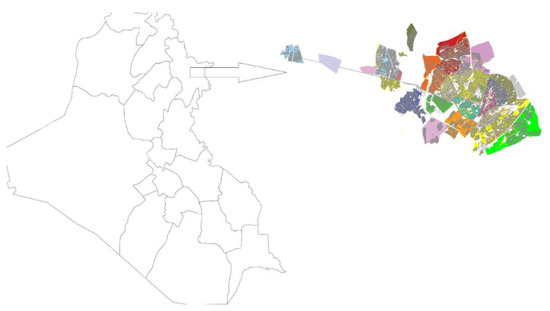
Figure 2.
Sulaymaniyah City on Iraq map location (Different colors represent sectors of the city of Sulaymaniyah).
3.2. Sampling System and Data Collection
The study used different procedures for data collection purposes. The data includes primary and secondary within both qualitative and quantitative types. The selected case’s urban street network data was downloaded from the city’s OSM website and prepared using AutoCAD software. The axial spatial map was analyzed with depth map X8 as the best program for analyses in the social-spatial research [6,41,42,43,44,46,47], and QGIS 3.16 was used for data presentation and illustration. In addition, data such as photos, land prices, and land-use diversity were collected on-site. The location of commercial activities, shops, service buildings, and residential areas was manually registered. The study used a sampling technique in geographical cluster sampling as the best sampling method for urban land price evaluations and market research. Then each sample stratifies into three groups: high, average, and low land prices, see Figure 3.
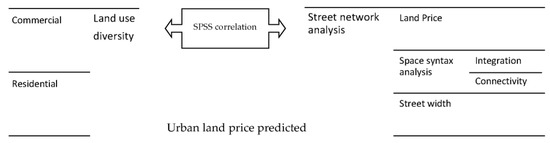
Figure 3.
The study’s methodological approaches.
4. Analysis and Results
4.1. Land Price and Syntactical Street Network Analysis
According to [41], global axial integration refers to the values of axial lines at an infinite radius, which can provide a picture of integration patterns on a large scale. Spatial syntax analysis of axial integration involves studying how each axis line relates to all other lines, considering the total number of trend changes [6]. Integration is also referred to as movement potential, and it measures how an axial line is connected to other lines, whether shallow or deep distributed (rings) or non-distributed. A space is considered integrated when all other areas in the urban environment are relatively close to it [41].
Like any other city, case study areas have varying urban land prices. Commercial activities host the city center and other parts of the metropolitan area. Land use and price distribution are based on integrating the street network. Commercial land is allocated on the most extended lines of spatially integrated networks with the highest land prices. In contrast, residential land is situated on deeper streets in the urban spatial network with lower land prices. The study has revealed that most commercial areas are found on the main urban network streets, which are arterial and collector types of roads—see Figure 4.
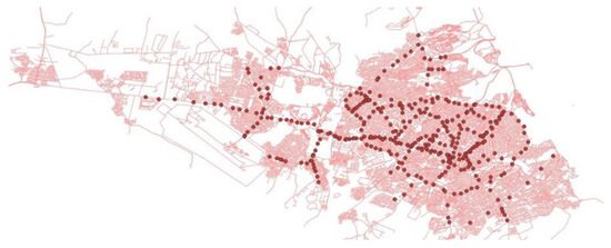
Figure 4.
Commercial distribution in the city of Sulaymaniyah (The circular spots indicate the areas where commercial activities take place).
According to the survey, the location of land can significantly influence its value. The distance of the land from the main street in the urban spatial network is the primary factor determining its price [48,49]. For instance, a small plot of land will likely have limited value and low prices due to its distance from transportation and lack of access to facilities. On the other hand, the weight and price of the property can increase if it is close to popular destinations in cities offering essential services, including primary transportation.
Sulaymaniyah is a city shaped by its central main lines, primarily used for commercial activities. However, different areas of the city have varying circumstances. For instance, land closer to the main street is more expensive than land located farther away. A study by [9] demonstrates that the street network connection plays a significant role in determining land value, and accordingly, prices can be predicted. Generally, land closer to the main street commands a higher price, while land farther away from the main road is less expensive. Urban land use and the movement of people are heavily influenced by the street network, as concluded by [41] in his analysis. The grid structure of streets plays a significant role in the distribution of land use and movement patterns within the urban landscape [43]. The arrangement of roads and urban layout determines the most convenient and direct routes for driving or walking and thus affects the city’s overall functionality. The layout of urban streets is a crucial factor influencing the flow of movement. According to [50], the street network’s connectivity can predict the land’s value. Typically, areas closer to main street networks are more easily accessible and where people tend to move, resulting in higher land prices [51]. Conversely, land prices decrease in locations where neighborhood buildings are further away from these networks.
According to [42], longer streets comprise the foreground route network, while shorter streets are part of the background routes network. Ref. [42] also notes that most residential streets tend to be metrically short. In the case selected, the urban plan does not follow a similar logic of urban structure; residential quarters are located in the background of the main accessible streets, which makes them less integrated with the main roads. As a result, the residential area has lower land prices than the commercial space. Table 1 reveals that the main commercial street is located in the highly integrated core of the urban network, resulting in the highest land prices. In contrast, the residential area is situated in a less integrated core with lower land prices.

Table 1.
Price of land in Sulaymaniyah City.
According to sources [43], the longitudinal land is closely connected to the global infrastructure. However, the network circuit varies in different locations, as noted by [52,53]. This means that the shape and width of streets significantly impact land prices. For example, Sabunkaran is a place near the city center with a median price of land due to low connectivity. The integration value is also standard because of the irregular shape of the street integration network, making it difficult to connect to the main structure of the urban street network. Please refer to Figure 5 for a visual representation.
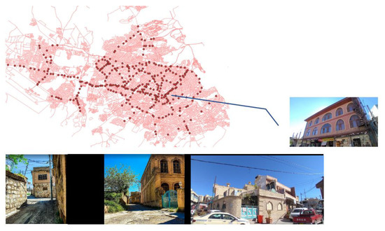
Figure 5.
The city center Sabunkaran districts (The circular spots indicate the areas where commercial activities take place).
When determining spatial integration in Sulaymaniyah City, we look at the number of times a road changes direction as it connects to other streets. The city’s well-connected urban street network shows that the most accessible and connected streets are located just after the red line. The red and yellow stripes on the map indicate that these roads have fewer direction changes compared to other streets, making them highly integrated within the most expensive commercial land. The green and blue lines offer potential accessibility as well, as shown in Figure 6. Sulaymaniyah City has been labeled as well-integrated in the global analysis, with a focus on the central business district. Additionally, the axial line analyses reveal a high degree of integration, indicating that there are more available streets in the area than in its depth.
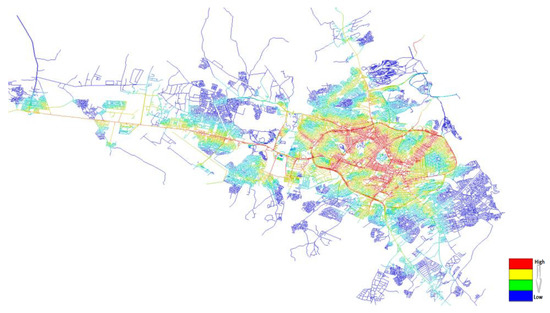
Figure 6.
Global integrations of Sulaymaniyah City.
The older parts of the case study have integration cores that are compact and irregular. As a result, the physical urban structure of the cities is made up of two types: deformed grids and linear extensions. The deformed grids have a continuous sub-structure from the city center, with secondary routes branching off from the main streets and either penetrating or segregating within the quarters or connecting to neighboring quarters. The city contains irregular shapes in the urban context, which is clearly illustrated in the urban label assessment. The majority of the city streets have high-value labeling, while some secondary roads have low-value labeling. The urban integration label indicates that the street network is highly integrated, as the segment street label values are very close, see Figure 7.
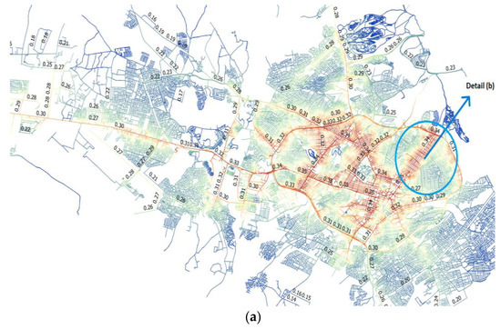
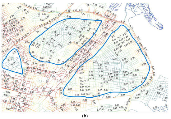
Figure 7.
Sulaymaniyah city (a) The global integration of the city (b) the city’s local and global integration values.
4.2. Street Classification and Land Price
The main road in Sulaymaniyah City is mostly commercialized and is considered an important collector and arterial road. Residential areas are separated by local roads with limited access to the main road, as shown in Figure 7. The land market highly values properties located near transit corridors that offer significant travel-time savings [54].
The concept of road hierarchy is used in urban design, where wider, high-priced roads are used for commercial activities, while residential areas are often isolated and have lower land prices. The street networks within residential areas are dominated by minor collectors and local roads that slow down traffic, leading to low connectivity between neighborhoods. This design can result in indirect and inefficient routes between locations, increasing travel distances and decreasing the viability of walking. As a result, land prices may fall further into residential neighborhoods. Please refer to Figure 8 for more information.
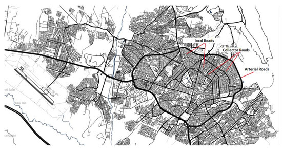
Figure 8.
Sulaymaniyah Street hierarchy.
A recent study examined the relationship between road width and land price. The findings revealed that arterial and major collector roads could increase the number of car trips, even if the distance traveled is shorter. The study by [55] conducted in San Francisco Bay area neighborhoods discovered that better accessibility could result in more frequent trips. Therefore, the high value of integration and connectivity with wider roads can increase travel distances to destinations and surrounding areas, leading to more commercial activity like supermarkets and shopping malls; this can result in higher land values in these areas compared to areas with poor integration, connectivity, and narrow roads. According to [5], centrality refers to the concentration of socioeconomic activities based on location and connectivity. In this case area, the axial connectivity shows potential connectivity with long lines in the urban plan, which enhances movement economy in most metropolitan areas. However, different circumstances can affect connectivity in certain areas due to social, economic, and policy influences. For example, in the selected case, the interconnected layout of traditional neighborhoods reduces distances, and these areas are primarily located in the central business district. Despite narrow roads, evaluations show that connectivity and integration in these neighborhoods are highly valued, and land prices around the CBD remain high due to its functional purpose.
The results of the study show that the price of land is greatly affected by integration, connectivity, and street width according to space syntax principles. After examining Sulaymaniyah City, it was found that commercial and shopping areas have the highest level of global spatial integration. The study also revealed that areas with diverse economic activities, wider roads, and well-connected street networks have the highest land prices. On the other hand, pedestrian-based locations with narrow roads tend to have lower land prices based on the analysis of local integration.
5. Discussion
Several factors can impact the value of land, either positively or negatively [56,57]. Land value is influenced by the surrounding environment and facility improvements [58]. Based on case study evaluations, the areas with the most economic activities are the arterial and major collector roads that are 12 m–32 m wide. These areas are typically located in city centers and offer the shortest walking and driving distances. As a result, they have the highest land prices. Accessible transportation options can boost economic activity and increase the regional land value [58,59].
The areas with the most interconnected streets are typically commercial and shopping areas. According to regional integration analysis, the densest street networks are located on arterial and collector roads that connect the commercial area to nearby residential areas. These roads also have the highest level of global integration. When analyzing urban structure, the length of a line is an important factor in determining its significance. Studies suggest that the longest street in a specific area can significantly enhance land value [60], particularly for commercial purposes. The main roads in Sulaymaniyah City are long and linear, running through all the public spaces. Shorter routes with widths ranging from 6m to 10m are positioned behind these long lines. The wider main roads significantly increase the land value and price of the city. For further details, please refer to Appendix A Table A1.
Upon analyzing the statistics of Sulaymaniyah City, it is evident that there is a significant correlation between the independent variables, namely integration, connectivity, street width, and the price of land as a dependent variable. The nonlinear correlation independent variables curve estimator is displayed in Figure 9. Additionally, Table 2 provides an overview of the model summary and parameter estimates for each indicator.
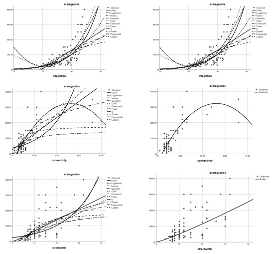
Figure 9.
Sulaymaniyah independent variables curve estimator.
Table 2.
Model Summary and Parameter Estimates.
The urban design process can be enhanced effectively by analytical methods that are applied at the specific stages of a design process [44,61]. Space syntax is a technology that examines how people use and navigate through space [41,43,62]. Unlike a purely theoretical analysis, it combines practical and theoretical approaches by observing human behavior. It focuses on cognition and how people experience space, recognizing that movement is essential to the lifeblood of cities. Without movement, cities lack meaning, and people cannot engage in social, economic, or communication transactions. As a result, movement is a driver of social and economic activities in cities [43,63]. Spatial street networks organize movements in urban areas, and their connection values significantly impact land value. In the Sulaymaniyah case study, high connection values increase land value, while poor connections result in lost value. Space syntax premises, including integration, connectivity, and street hierarchy, are the core of urban land price determination. The finding demonstrated that the syntactical premises, including integration and connectivity, and street width highly correlate with the land price. Therefore, those independent variables can be used to determine the urban land price. As the main aim of the research, the study can predict the model for an urban spatial land price that can predict more than 76% price of urban land as R2 = 76.6%, see Table 3. Based on Table 3, Table 4 and Table 5, The expected model is as follows:
Y = β + β1x1 + β2x2 + β3x3
Y = β+0.438x1 + 0.338x2 + 0.299x3
Table 3.
Indicates the statistical correlation Model summary.
Table 4.
Regression analysis between street width, integration, and connectivity.
Table 5.
Statistical coefficients between study indicators.
While:
Y = Land Price
x1 = Integration value
x2 = Connectivity value
x3 = Street width value
Using street networks as a model provides a particular analytical configuration that can determine density and land use [64,65,66]; there is a positive correlation between the density of streets near homes and commuting distance, as well as the frequency of using public transportation or private vehicles for commuting trips [67,68]. Moreover, centrality has been addressed in configurational studies as a spatial process in a specific network using spatial analysis [69,70]. This method has proven effective in experimental research linking economic and spatial variables. The result of this study can be added to the urban literature gap in terms of urban land price determination; the model provided can be used for future urban street networks and urban built environment improvements to enhance urban land value and price.
6. Conclusions
In the field of urban design and analysis, Space Syntax is considered the best software tool. It can be used in combination with bid rent theory in urban economics to analyze and explain specific urban areas. Through various approaches, this study has demonstrated that the spatial configuration of an urban area and its economic theory are closely related and can be used to create a suitably built environment. Business owners always strive to maximize their profits and therefore seek out ideal locations to attract potential customers. This study found that the ideal location is on the longest axial line with a high degree of connectivity in the global integration and wider width. Specifically, the ideal location is on the longest and most expansive axial line with the nearest node at the global integration level. The result of this study can help business owners choose the best location for their investment.
According to the study, factors like street accessibility and street hierarchy are the main indicators for land value and price estimations; there is a positive correlation between medium and high levels of integration and connectivity and increased land value on arterial roads. Generally, land prices are higher on arterial and major collector roads with wider roads, while they are lower on minor collector and local roads with narrower roads. Wider roads can increase the number of car trips and lead to more frequent trips. Therefore, improved street network integration and connectivity with wider roads in Sulaymaniyah City can lead to higher land values and increased commercial activity. Consequently, the study proves that creating a functional urban street network is crucial in optimizing the use of urban land value. Therefore, urban planning, development, and design require a space syntax system to determine the land’s value for future improvements. On the other side, urban planners and designers should consider street hierarchy for urban future economic enhancements in terms of land value and price. Different community categories can benefit from this study regarding this topic, and people usually fall into two categories: designers and planners; and financiers and real estate professionals. If you are a designer or planner, there are specific steps you can take to enhance street connectivity and improve land value. These include decreasing traffic on arterial roads, creating more direct routes to make it easier for non-motorized modes of transportation such as walking and cycling, and improving the quality of local roads. All of these efforts lead to more efficient transit service and make a connection between urban road connectivity and land price improvements.
The results of this study have significant implications for both theoretical and practical applications. Theoretically, it can offer valuable insights into urban economics, spatial planning, and transportation. On a practical level, it can assist urban planners in designing future infrastructure based on the built environment that enhances the land value and aids investors and those in the real estate industry in determining urban land value and pricing more accurately. Additionally, these findings can be utilized in future urban economic studies to establish a new land pricing program based on space syntax principles.
Author Contributions
Con-capitalization, H.M.A. and M.A.I.; methodology, H.M.A. and M.A.I.; software, H.M.A.; validation, M.A.I.; formal analysis, H.M.A.; investigation, H.M.A. and M.A.I.; resources, H.M.A. and M.A.I.; data curation, H.M.A.; writing—original draft preparation, H.M.A.; writing; review and editing H.M.A., M.A.I. and W.S.A.-H.; visualization, H.M.A.; supervision, M.A.I. and W.S.A.-H. All authors have read and agreed to the published version of the manuscript.
Funding
This research received no external funding.
Institutional Review Board Statement
H.M.A. is a Ph.D. student at Salahaddin University, under the supervision of M.A.I. from Tishik International University and W.S.A.-H. from the University of Technology, Baghdad. All the data included in the article submitted to the Building Journal at MDPI for research purposes were conducted with the approval of both the supervisor and the universities. This was conducted in accordance with the requirements of the College of Engineering and the research center at Salahaddin University, with a protocol code of (8 T).
Informed Consent Statement
Not applicable.
Data Availability Statement
Data is unavailable due to privacy restrictions.
Acknowledgments
We express our gratitude to the Sulaymaniyah Municipality Administration and Real Estates for their constant support throughout the study.
Conflicts of Interest
The authors declare no conflict of interest.
Appendix A
Table A1 below displays the importance and correlation between independent variables to obtain further details on selected samples.
Table A1.
Samples and land price indicators under the use of space syntax premises.
Table A1.
Samples and land price indicators under the use of space syntax premises.
| Case Number | Samples | Land Price | Integration | Connectivity | Street Width |
|---|---|---|---|---|---|
| 1 | Setwan LR * | 300 | 0.2047 | 4 | 10 |
| 2 | Setwan CR * | 400 | 0.2221 | 4 | 12 |
| 3 | Setwan C * | 500 | 0.2477 | 5 | 15 |
| 4 | Zerinok LR | 500 | 0.2453 | 3 | 10 |
| 5 | Zerinok CR | 1250 | 0.2773 | 4 | 20 |
| 6 | Ibrahim ahmad LR | 350 | 0.2137 | 4 | 10 |
| 7 | Ibrahim ahmad CR | 450 | 0.2391 | 4 | 20 |
| 8 | Ibrahim ahmad C | 1500 | 0.277 | 9 | 30 |
| 9 | Qrga LR | 280 | 0.1973 | 6 | 12 |
| 10 | Qrga CR | 400 | 0.2272 | 4 | 20 |
| 11 | Qrga C | 1000 | 0.2586 | 7 | 30 |
| 12 | Tasluja LR | 50 | 0.1414 | 4 | 7 |
| 13 | Tasluja CR | 200 | 0.2244 | 6 | 10 |
| 14 | Tasluja C | 500 | 0.244 | 5 | 20 |
| 15 | kandaswra LR | 100 | 0.1602 | 4 | 6 |
| 16 | kandaswra CR | 300 | 0.2058 | 4 | 15 |
| 17 | qularaisy LR | 150 | 0.1858 | 5 | 7 |
| 18 | qularaisy CR | 300 | 0.2276 | 4 | 10 |
| 19 | Rapareen LR | 250 | 0.197 | 4 | 20 |
| 20 | Rapareen LR 1 | 125 | 0.1848 | 4 | 7 |
| 21 | Rapareen CR | 450 | 0.2948 | 3 | 20 |
| 22 | Rapareen CR 2 | 300 | 0.2048 | 4 | 15 |
| 23 | Rapareen C | 1600 | 0.2964 | 11 | 30 |
| 24 | Rapareen C 3 | 1000 | 0.2838 | 5 | 30 |
| 25 | Farmanbaran LR | 350 | 0.217 | 4 | 8 |
| 26 | Farmanbaran CR | 500 | 0.2593 | 4 | 8 |
| 27 | Farmanbaran C | 1400 | 0.3105 | 9 | 30 |
| 28 | Majy bag LR | 350 | 0.2306 | 4 | 6 |
| 29 | Majy bag CR | 400 | 0.2355 | 6 | 10 |
| 30 | Majy bag C | 850 | 0.2746 | 8 | 22 |
| 31 | Khabat LR | 300 | 0.2572 | 6 | 7 |
| 32 | khabat CR | 350 | 0.2867 | 6 | 12.5 |
| 33 | khabat C | 1300 | 0.3127 | 9 | 26 |
| 34 | qazi muhamad LR | 400 | 0.2891 | 4 | 7 |
| 35 | qazi muhamad CR | 750 | 0.3103 | 4 | 7 |
| 36 | qazi muhamad C | 2500 | 0.3332 | 11 | 22 |
| 37 | Bakrajo LR | 200 | 0.1914 | 3 | 7 |
| 38 | Bakrajo CR | 650 | 0.2508 | 5 | 12 |
| 39 | Bakrajo C | 1500 | 0.2862 | 6 | 22 |
| 40 | Hawary Shar LR | 300 | 0.2345 | 5 | 7 |
| 41 | Hawary Shar CR | 700 | 0.2668 | 4 | 10 |
| 42 | Hawary Shar C | 1500 | 0.2716 | 8 | 22 |
| 43 | Sarchnar LR | 350 | 0.241 | 3 | 10 |
| 44 | Sarchnar CR | 650 | 0.2992 | 4 | 10 |
| 45 | Sarchnar C | 2200 | 0.3137 | 11 | 20 |
| 46 | Azadi LR | 350 | 0.2425 | 4 | 6.5 |
| 47 | Azadi CR | 650 | 0.2975 | 3 | 7 |
| 48 | Azadi C | 2200 | 0.3145 | 13 | 17 |
| 49 | Ibrahim pasha LR | 350 | 0.2633 | 6 | 5.5 |
| 50 | Ibrahim pasha CR | 600 | 0.298 | 4 | 8.5 |
| 51 | Ibrahim pasha C | 2000 | 0.3046 | 11 | 22 |
| 52 | Zargatay kon LR | 400 | 0.2657 | 4 | 10 |
| 53 | Zargata CR | 650 | 0.3003 | 4 | 10 |
| 54 | Zargata C | 2500 | 0.3222 | 22 | 15 |
| 55 | Slemany new LR | 450 | 0.2583 | 4 | 8 |
| 56 | Slemany new CR | 750 | 0.3175 | 4 | 12 |
| 57 | Slemany new C | 2100 | 0.3412 | 12 | 12 |
| 58 | Bakhtiary LR | 500 | 0.239 | 4 | 8 |
| 59 | Bakhtiary CR | 800 | 0.3017 | 5 | 8 |
| 60 | Bakhtiary C | 3000 | 0.3522 | 11 | 32 |
| 61 | Kareza wishk LR | 300 | 0.2985 | 4 | 7 |
| 62 | Kreza wishk CR | 600 | 0.3179 | 4 | 10 |
| 63 | Kareza wishl C | 2000 | 0.332 | 13 | 15 |
| 64 | Chwarbax LR | 500 | 0.2899 | 4 | 8 |
| 65 | Chwarbax CR | 700 | 0.3198 | 5 | 12 |
| 66 | Chwarbax C | 1500 | 0.3355 | 7 | 12 |
| 67 | Hawara barza LR | 450 | 0.2579 | 5 | 8 |
| 68 | Hawara barza CR | 700 | 0.2725 | 4 | 10 |
| 69 | Hawara barza C | 2000 | 0.3391 | 36 | 22 |
| 70 | Ashty LR | 600 | 0.2844 | 4 | 8 |
| 71 | Ashty CR | 1000 | 0.3062 | 4 | 12 |
| 72 | Ashty C | 3000 | 0.3368 | 24 | 12 |
| 73 | Malkany LR | 200 | 0.2397 | 1 | 4 |
| 74 | Malkany CR | 300 | 0.28 | 5 | 7 |
| 75 | Malkany C | 1300 | 0.329 | 3 | 10 |
| 76 | Alinajy LR | 750 | 0.2976 | 4 | 8 |
| 77 | Alinajy CR | 1100 | 0.3266 | 4 | 10 |
| 78 | Alinajy C | 3000 | 0.3325 | 7 | 15 |
| 79 | Kurdsat LR | 400 | 0.2024 | 3 | 10 |
| 80 | Kurdsat CR | 700 | 0.2226 | 4 | 10 |
| 81 | Kurdsat C | 1000 | 0.2337 | 6 | 12 |
| 82 | Tuymalik LR | 450 | 0.2573 | 5 | 10 |
| 83 | Tuymalik CR | 1000 | 0.3233 | 3 | 10 |
| 84 | Tuymalik C | 3500 | 0.3391 | 36 | 20 |
| 85 | Reaya shabab LR | 500 | 0.2871 | 4 | 8 |
| 86 | Reaya shabab CR | 1000 | 0.3137 | 3 | 8 |
| 87 | Reaya shabab C | 3000 | 0.3229 | 7 | 28 |
| 88 | Kosay cham LR | 100 | 0.1622 | 4 | 8 |
| 89 | Kosay cham CR | 220 | 0.2263 | 6 | 8 |
| 90 | Kosay cham C | 600 | 0.2645 | 3 | 15 |
| 91 | Aqary (shorish) LR | 800 | 0.3035 | 5 | 10 |
| 92 | Aqary (shorish) CR | 1200 | 0.3184 | 5 | 12 |
| 93 | Aqary (shorish) C | 4000 | 0.3457 | 13 | 32 |
| 94 | Chwarchra LR | 200 | 0.1947 | 3 | 10 |
| 95 | Chwarchra CR | 400 | 0.2424 | 4 | 20 |
* LR = land on a local road * CR = land on a collector road. * C = land used for commercial activities, on arterial type of roads).
References
- Ti, E. Property values as a function of law and policy. Int. Real Estate Rev. 2023, 26, 127–142. [Google Scholar] [CrossRef] [PubMed]
- Yoo, J.; Frederick, T. The varying impact of land subsidence and earth fissures on residential property values in Maricopa County—A quantile regression approach. Int. J. Urban Sci. 2017, 21, 204–216. [Google Scholar] [CrossRef]
- Feilmayr, W. Levels and development of real estate prices in different Austrian regions. In Proceedings of the 22nd Annual European Real Estate Society Conference, Istanbul, Turkey, 24 June 2015. [Google Scholar] [CrossRef]
- Gopy-Ramdhany, N.; Seetanah, B. Does immigration affect residential real estate prices? Evidence from Australia. Int. J. Hous. Mark. Anal. 2020, 15, 290–314. [Google Scholar] [CrossRef]
- Narvaez, L.; Penn, A.; Griffiths, S. Spatial Configuration and Bid Rent Theory: How Urban Space Shapes the Urban Economy. 2013. Academia.edu. Available online: https://www.academia.edu/4996270/Spatial_Configuration_and_Bid_Rent_Theory_How_urban_space_shapes_the_urban_economy (accessed on 15 June 2022).
- Van Nes, A.; Yamu, C. Space syntax applied in urban practice. Introd. Space Syntax. Urban Stud. 2021, 7, 213–237. [Google Scholar] [CrossRef]
- Yoshida, T.; Yamagata, Y.; Chang, S.; De Gooyert, V.; Seya, H.; Murakami, D.; Voulgaris, G. Spatial Modeling and Design of Smart Communities; Yamagata, Y., Yang, P.P.J., Eds.; Urban Systems Design: London, UK, 2020; pp. 199–255. [Google Scholar] [CrossRef]
- Zhou, Y.; Tian, Y.; Jim, C.Y.; Liu, X.; Luan, J.; Yan, M. Effects of public transport accessibility and property attributes on housing prices in Polycentric Beijing. Sustainability 2022, 14, 14743. [Google Scholar] [CrossRef]
- Liu, Y.; Zheng, B.; Huang, L.; Tang, X. Urban Residential Land Value Analysis: Case Danyang, China. Geo-Spat. Inf. Sci. 2007, 10, 228–234. Available online: https://www.tandfonline.com/doi/pdf/10.1007/s11806-007-0066-4 (accessed on 12 August 2021).
- Li, C.; Meng, Y.; Li, Y.; Ge, J.; Zhao, C. Inter-metropolitan land-price characteristics and patterns in the Beijing-Tianjin-Hebei Urban Agglomeration in China. Sustainability 2019, 11, 4726. Available online: https://www.mdpi.com/2071-1050/11/17/4726 (accessed on 12 December 2022). [CrossRef]
- Fujita, M. Urban Economic Theory; Cambridge University Press: Cambridge, UK, 2003. [Google Scholar]
- Gonçalves, J.A.; Portugal, L.d.; Nassi, C.D. Centrality indicators as an instrument to evaluate the integration of urban equipment in the area of influence of a rail corridor. Transp. Res. Part A Policy Pract. 2009, 43, 13–25. [Google Scholar] [CrossRef]
- Bohman, H.; Nilsson, D. Borrowed sizes: A hedonic price approach to the value of netowrk structure in public transport systems. J. Transp. Land Use 2021, 14, 87–103. [Google Scholar] [CrossRef]
- Morales, J.; Flacke, J.; Morales, J.; Zevenbergen, J. Mapping urban accessibility in data scarce contexts using space syntax and location-based methods. Appl. Spat. Anal. Policy 2019, 12, 205–228. [Google Scholar] [CrossRef]
- Webster, C. Pricing accessibility: Urban morphology, design and missing markets. Prog. Plan. 2010, 73, 77–111. [Google Scholar] [CrossRef]
- Shearmur, R.G. What Is an Urban Structure? Challenge of Foreseeing 21st Century Spatial Patterns of the Urban Economy. Canadian Electronic Library. 2013. Available online: https://www.researchgate.net/profile/Carlos-Garrocho3/publication/297694664_Advances_in_Commercial_Geography_prospects_methods_and_applications/links/56e03ee808ae9b93f79c2964/Advances-in-Commercial-Geography-prospects-methods-and-applications.pdf#page=95 (accessed on 11 November 2021).
- Asadi, S.; Heshmati, M.; Tavana, M.; Di Caprio, D. A logit-based model for measuring the effects of transportation infrastructure on land value. Transp. Plan. Technol. 2017, 40, 143–166. [Google Scholar] [CrossRef]
- Koning, R.d.; Tan, W.G.; van Nes, A. Assessing spatial configurations and transport energy usage for planning sustainable communities. Sustainability 2020, 12, 8146. [Google Scholar] [CrossRef]
- Sodhi, N.; Shirowzhan, S.; Sepasgozar, S. The impact of increased density on residential property values in Sydney, New South Wales. Buildings 2021, 11, 650. [Google Scholar] [CrossRef]
- Duncan, M. The impact of transit-oriented development on housing prices in San Diego, CA. Urban Stud. 2010, 48, 101–127. [Google Scholar] [CrossRef] [PubMed]
- Kok, N.; Monkkonen, P.; Quigley, J.M. Land use regulations and the value of land and housing: An intra-metropolitan analysis. J. Urban Econ. 2014, 81, 136–148. [Google Scholar] [CrossRef]
- Esmaeilpoorarabi, N.; Yigitcanlar, T. User-Centric Innovation District Planning: Lessons from Brisbane’s leading innovation districts. Buildings 2023, 13, 883. [Google Scholar] [CrossRef]
- Al-Saaidy, H.J.E.; Alobaydi, D. Studying street centrality and human density in different urban forms in Baghdad, Iraq. Ain Shams Eng. J. 2021, 12, 1111–1121. [Google Scholar] [CrossRef]
- Wolhuter, K.M. Geometric Design of Roads Handbook; CRC Press, Taylor & Francis Group: Boca Raton, FL, USA, 2021. [Google Scholar]
- Forbes, G. Urban Roadway Classification before the Design Begins TRB Circular E-C019: Urban Street Symposium. Available online: https://nacto.org/docs/usdg/urban_roadway_classification_before_the_design_begins_forbes.pdf (accessed on 8 May 2023).
- Han, B.; Sun, D.; Yu, X.; Song, W.; Ding, L. Classification of Urban Street Networks based on tree-like network features. Sustainability 2020, 12, 628. [Google Scholar] [CrossRef]
- Mehta, V.; Bosson, J.K. Revisiting lively streets: Social interactions in public space. J. Plan. Educ. Res. 2018, 41, 160–172. [Google Scholar] [CrossRef]
- Tak, S.; Kim, S.; Yu, H.; Lee, D. Analysis of relationship between road geometry and automated driving safety for Automated Vehicle-based Mobility Service. Sustainability 2022, 14, 2336. [Google Scholar] [CrossRef]
- Bassil, K.; Rilkoff, H.; Belmont, M.A.; Banaszewska, A.; Campbell, M. Pedestrian and Cyclist Safety in Toronto, 2015, Research Gate. Available online: https://www.researchgate.net/publication/280576352_Pedestrian_and_Cyclist_Safety_in_Toronto (accessed on 8 May 2023).
- Vitkienė, J.; Puodžiukas, V.; Žilionienė, D. New approach to the lithuanian road classification based on Worldwide Experience. In Proceedings of the 10th International Conference on Environmental Engineering, Vancouver, BC, Canada, 23–24 October 2017. [Google Scholar] [CrossRef]
- Page, O. Equity impacts and challenges of highway access management in an emerging economy. Transp. Res. Rec. J. Transp. Res. Board 2005, 1939, 166–173. [Google Scholar] [CrossRef]
- Martínez, F. This Place Has Potential’: Trash, Culture, and Urban Regeneration in Tallinn, Estonia. 2018. Available online: https://www.researchgate.net/publication/323932804_’This_place_has_potential’_Trash_culture_and_urban_regeneration_in_Tallinn_Estonia (accessed on 18 June 2022).
- Ezebilo, E. Evaluation of Affordable Housing Program in Papua New Guinea: A case of Port Moresby. Buildings 2017, 7, 73. [Google Scholar] [CrossRef]
- Button, K. Where Did the “New Urban Economics” Go after 25 Years? Adv. Spat. Sci. 2000, 9, 30–50. [Google Scholar] [CrossRef]
- Gorback, C.S.; Keys, B.J. Global Capital and Local Assets: House Prices, Quantities, and Elasticities. Natl. Bur. Econ. Res. 2020. preprint. [Google Scholar] [CrossRef]
- Hu, S.; Yang, S.; Li, W.; Zhang, C.; Xu, F. Spatially non-stationary relationships between urban residential land priceand impact factors in Wuhan City, China. Appl. Geogr. 2016, 68, 48–56. [Google Scholar] [CrossRef]
- Yin, Y.; Zeng, X.; Zhong, S.; Liu, Y. How real estate shocks affect manufacturing value chain upgrading: Evidence from China. Buildings 2022, 12, 546. [Google Scholar] [CrossRef]
- Aksoy, H.; Kaptan, S. Simulation of future forest and land use/cover changes (2019–2039) using the cellular automata-markov model. Geocarto Int. 2020, 37, 1183–1202. [Google Scholar] [CrossRef]
- Mills, E.S.; MacKinnon, J. Notes on the new urban economics. Bell J. Econ. Manag. Sci. 1973, 4, 593. [Google Scholar] [CrossRef]
- Verheye, W. The Value and Price of Land. 2003. Available online: http://www.eolss.net/sample-chapters/c19/e1-05-03-03.pdf (accessed on 4 August 2022).
- Hillier, B.; Hanson, J. The Social Logic of Space; Cambridge University Press: Cambridge, UK, 1984; Available online: https://www.cambridge.org/core/books/social-logic-of-space/6B0A078C79A74F0CC615ACD8B250A985 (accessed on 3 May 2021).
- Hiller, H.; Hanson, J.; Peponis, J. Syntactic analysis of settlements. Arch. Comport/Arch. Behav. 1987, 3, 217–231. Available online: https://www.academia.edu/2891828/Hillier_W_Hanson_J_Peponis_J_1987_Syntactic_analysis_of_settlements_Architecture_et_Comportement_Architecture_and_Behaviour_3_217-231 (accessed on 19 May 2021).
- Hillier, B. Space is the Machine: A Configurational Theory of Architecture; Cambridge University Press: Cambridge, UK, 1996; Available online: https://spaceisthemachine.com/ (accessed on 11 April 2021).
- Karimi, K. A configurational approach to analytical urban design: “space syntax” methodology. Urban Des. Int. 2012, 17, 297–318. [Google Scholar] [CrossRef]
- Jarah, S.; Zhou, B.; Abdullah, R.J.; Lu, Y.; Yu, W. Urbanization and urban sprawl issues in city structure: A case of the Sulaymaniyah Iraqi Kurdistan region. Sustainability 2019, 11, 485. [Google Scholar] [CrossRef]
- Figueiredo, L.; Amorim, L. Decoding the Urban Grid: Or Why Cities Are Neither Trees Nor Perfect Grids. In Proceedings of the Sixth International Space Syntax Symposium, Istanbul, Turkey, 12–15 June 2007; Available online: https://discovery.ucl.ac.uk/id/eprint/2694/ (accessed on 26 March 2022).
- Yamu, C.; van Nes, A.; Garau, C. Bill Hillier’s Legacy: Space syntax—A synopsis of basic concepts, measures, and empirical application. Sustainability 2021, 13, 3394. [Google Scholar] [CrossRef]
- Kopczewska, K.; Kopyt, M. and Ćwiakowski, Spatial interactions in business and Housing Location Models. Land 2021, 10, 1348. [Google Scholar] [CrossRef]
- Abdulla, H.; Ibrahim, M. The impact of urban spatial plan on land value: An approach system to relating space syntax premises to the land price. Sustainability 2023, 15, 7239. [Google Scholar] [CrossRef]
- Hillier, B.; Iida, S. Network and Psychological Effects in Urban Movement. In Proceedings of the Spatial Information Theory: International Conference, COSIT 2005, Ellicottville, NY, USA, 14–18 September 2005; pp. 475–490. Available online: https://discovery.ucl.ac.uk/id/eprint/1232/ (accessed on 18 March 2022).
- Van Nes, A. Centrality and development in the Rijn land region. In Proceedings of the 6th Space Syntax Symposium (6SSS), Istanbul, Turkiye, 12–15 June 2007; Available online: http://spacesyntaxistanbul.itu.edu.tr/papers/longpapers/015%20-%20vanNes.pdf (accessed on 18 March 2022).
- Boeing, G. Urban Spatial Order: Street Network Orientation, configuration, and Entropy. Appl. Netw. Sci. 2019, 4, 67. Available online: https://appliednetsci.springeropen.com/articles/10.1007/s41109-019-0189-1 (accessed on 22 December 2021). [CrossRef]
- Spina, L.D.; Carbonara, S.; Stefano, D.; Viglianisi, A. Circular evaluation for ranking adaptive reuse strategies for abandoned industrial heritage in vulnerable contexts. Buildings 2023, 13, 458. [Google Scholar] [CrossRef]
- Cervero, R.; Kang, C.D. Bus rapid transit impacts land uses and land values in Seoul, Korea. Transp. Policy 2011, 18, 102–116. [Google Scholar] [CrossRef]
- Handy, S. Regional versus and local accessibility: Implementation of network travel. Transp. Res. Rec. 1993, 1400, 58–66. Available online: https://escholarship.org/content/qt2z79q67d/qt2z79q67d_noSplash_c5dcd7915c0255857329643b81747b8c.pdf?t=mc2sq2 (accessed on 20 September 2021).
- Mathur, S. Impact of urban growth boundary on housing and land prices: Evidence from King County, Washington. Hous. Stud. 2013, 29, 128–148. [Google Scholar] [CrossRef]
- Mitchell, D.; Myers, M. Land Valuation and Taxation: Key Tools for Disaster Risk Management. In Proceedings of the International Federation of Surveyors Working Week, Abuja, Nigeria, 28 May–1 June 2013. [Google Scholar]
- Saputra, E.; Ariyanto, I.S.; Ghiffari, R.A.; Fahmi, M.S. Land Value in a disaster-prone urbanized coastal area: A case study from Semarang City, Indonesia. Land 2021, 10, 1187. [Google Scholar] [CrossRef]
- Rakhmatulloh, A.R.; Buchori, I.; Pradoto, W.; Riyanto, B.; Winarendri, J. What is the role of land value in the urban corridor? IOP Conf. Ser. Earth Environ. Sci. 2018, 123, 012033. [Google Scholar] [CrossRef]
- Goetz, A.R. The Geography of Transport Systems, second edition—By Jean-Paul Rodrigue, Claude Comtois, and Brian Slack. Econ. Geogr. 2010, 86, 321–322. [Google Scholar] [CrossRef]
- Karimi, K. Space syntax: Consolidation and transformation of an urban research field. J. Urban Des. 2017, 23, 1–4. [Google Scholar] [CrossRef]
- Bafna, S. Space Syntax: A Brief Introduction to Its Logic and Analytical Techniques. Environ. Behav. 2003, 35, 17–29. [Google Scholar] [CrossRef]
- Shen, Y.; Karimi, K. The economic value of streets: Mix-scale spatio-functional interaction and housing price patterns. Appl. Geogr. 2017, 79, 187–202. [Google Scholar] [CrossRef]
- Zadeh, A.S.M.; Rajabi, M.A. Analyzing the effect of the street network configuration on the efficiency of an urban transportation system. Cities 2013, 31, 285–297. [Google Scholar] [CrossRef]
- Shimizu, K.; Nishi, H.; Kishimoto, T. Estimation of pedestrian density and speed on street network using smartphone spatio-temporal data, Reports of the City Planning Institute of Japan. In Proceedings of the 12th International Space Syntax Symposium, SSS 2019, Beijing, China, 8–13 July 2019; Volume 18, pp. 64–71. [Google Scholar] [CrossRef]
- Soltani, S.; Gu, N.; Ochoa, J.; Sivam, A.; Sun, X. Spatial configuration and density; How Building Density Affects Spatial Arrangement of a Neighbourhood. Int. Rev. Spat. Plan. Sustain. Dev. 2020, 8, 87–100. [Google Scholar] [CrossRef]
- Mehriar, M.; Masoumi, H.; Aslam, A.B.; Gillani, S.M.; Suhail, T.; Zulfiqar, A. The relations between Street Network Configuration and travel behavior in Pakistan; the optimal level of street connectivity for more active mobility. Appl. Sci. 2021, 11, 11015. [Google Scholar] [CrossRef]
- Ahmadzai, F. Analyses, and modeling of urban land use and road network interactions using spatial-based disaggregate accessibility to land use. J. Urban Manag. 2020, 9, 298–315. [Google Scholar] [CrossRef]
- Cutini, V. Centrality and land use: Three case studies on the configurational hypothesis. Cybergeo 2001. preprint. [Google Scholar] [CrossRef]
- Pont, M.B.; Marcus, L.H. 043 What Can Typology Explain that Configuration Cannot? 2015, Research Gate. Available online: https://www.researchgate.net/profile/Meta-Berghauser-Pont/publication/282360200_043_What_can_typology_explain_that_configuration_can_not/links/560e7e5408ae6b29b49876f4/043-What-can-typology-explain-that-configuration-can-not.pdf (accessed on 8 May 2023).


Disclaimer/Publisher’s Note: The statements, opinions and data contained in all publications are solely those of the individual author(s) and contributor(s) and not of MDPI and/or the editor(s). MDPI and/or the editor(s) disclaim responsibility for any injury to people or property resulting from any ideas, methods, instructions or products referred to in the content. |
© 2023 by the authors. Licensee MDPI, Basel, Switzerland. This article is an open access article distributed under the terms and conditions of the Creative Commons Attribution (CC BY) license (https://creativecommons.org/licenses/by/4.0/).