Article

Sedimentary Processes and Source-to-Sink System of the Zhuhai Formation in the Southern Steep Slope Zone of the Zhu III Depression Offshore SE China


1
College of Geophysics, China University of Petroleum (Beijing), Beijing 102249, China
2
Zhanjiang Branch, China National Offshore Oil Corporation (CNOOC), Zhanjiang 524057, China
*
Authors to whom correspondence should be addressed.
Minerals 2026, 16(1), 57; https://doi.org/10.3390/min16010057
Submission received: 28 October 2025 / Revised: 14 December 2025 / Accepted: 18 December 2025 / Published: 6 January 2026
(This article belongs to the Special Issue Deep-Time Source-to-Sink in Continental Basins)

Abstract

The Pearl River Mouth Basin is a significant hydrocarbon basin in the northern part of the South China Sea, where deep hydrocarbon exploration has become increasingly important research in recent years. However, the current understanding of the source-to-sink and depositional systems of the Paleogene Zhuhai Formation is still limited, which restricts the exploration and discovery of large-scale sand bodies. Based on core observation, heavy mineral analysis, and well-seismic integrated analysis, this paper clarifies the development of a fan delta-tidal flat depositional and the source-to-sink systems of the Zhuhai Formation. The bedrock in the source region primarily consists of granite, Mesozoic sandstone, and tuff. The source region is divided into five parts (A1–A5), with seven main valleys (V1–V7) developed, supplying sediments to five depositional areas (S1–S5). Additionally, a fault-slope type coupled valley–fan depositional model is established for the study area, revealing the spatiotemporal distribution and main controlling factors of the fan delta system in a steeply dipping boundary fault environment. Catchment area, valley length, and cross-sectional area show a strong positive correlation with sedimentary system scale. Increased elevation difference enhances sediment transport potential energy, while reduced width-to-depth ratio strengthens hydrodynamic forces, promoting sedimentary sand body development and sedimentary system expansion.

1. Introduction

In recent years, Paleogene deep exploration has emerged as a new frontier for exploration, serving as the primary direction for achieving breakthroughs in hydrocarbon production in old oilfields [1,2,3,4]. During the depositional period of the Paleogene Zhuhai Formation, the Zhu III Depression underwent complex tectonic evolution, resulting in the development of a diverse sedimentary system [5,6,7,8].
Due to early hydrocarbon exploration focusing mainly on shallow strata, basic geological research on the deep strata Zhuhai formation, such as the source-to-sink (S2S) system, remains incomplete [9,10]. The insufficient study of the S2S system and sedimentary hydrodynamics constrained the understanding of large-scale sand body distribution patterns and high-quality reservoir-forming mechanisms [11]. With ongoing advancement of geological exploration technology, particularly in 3D seismic imaging, high-resolution sequence stratigraphy, and S2S theory, robust technical support has been provided for in-depth investigations into the source-to-sink and sedimentary systems of the Zhuhai Formation [9,11,12,13,14,15]. Researchers worldwide have made significant progress in studying S2S and sedimentary systems, providing valuable references for this study [11,13,16,17,18]. The integration of high-precision 3D seismic data, heavy mineral analysis, zircon U-Pb dating, and other provenance analysis techniques provides a robust approach for visually characterizing the spatial location and directional orientation of provenance areas [2,14,19,20].
The source-to-sink (S2S) system involves the transport of detrital and soluble materials from source regions through transport systems to their final deposition within basins [13,15]. S2S system analysis integrates three key processes: the erosion of detrital and soluble materials from source regions, their transport, and the distribution patterns of sedimentary systems in depositional areas [21,22,23,24]. This approach enables a comprehensive analysis of both internal and external controlling factors within the system, along with their resultant outcomes, thereby facilitating the prediction of geological events [25,26,27,28]. The application of quantitative and semi-quantitative analyses to the key components of the S2S system, namely source, pathway, margin, and sink, substantially improves the accuracy and predictability of research conducted within this framework [29,30,31,32,33].
This study integrates core, drilling, logging, analytical data, and high-resolution seismic data to comprehensively characterize the sedimentary systems of the Zhuhai Formation. Through source-to-sink (S2S) system analysis, we delineate the sediment transport pathways and depositional patterns from the source to sink. This work explains the primary factors controlling the depositional process of the Zhuhai Formation and establishes an S2S model. The findings provide a robust theoretical framework for future deep hydrocarbon exploration.

2. Geological Context

2.1. Tectonic Setting

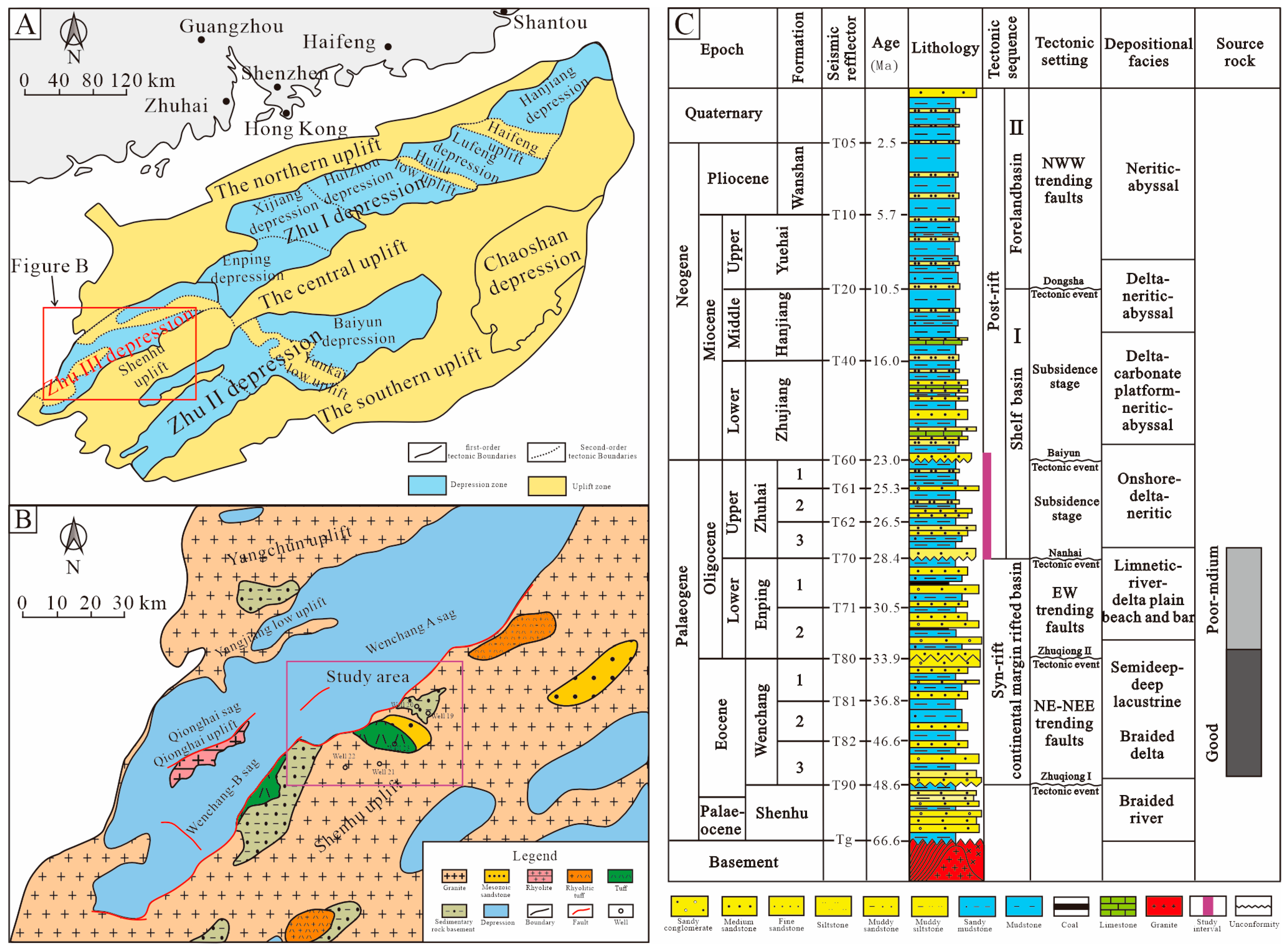
The Pearl River Mouth Basin, located offshore Southeast China, is a Cenozoic epicontinental extensional basin that is highly prolific in hydrocarbons [5,6,7,8]. The basin’s formation and evolution were shaped by multiple phases of tectonic activity (Figure 1A). The Pearl River Mouth Basin can be divided internally into several tectonic units, among which the Zhu III Depression is the largest and most hydrocarbon-rich depression in the western part of the Pearl River Mouth Basin.
The Wenchang A Sag, a secondary tectonic unit within the Zhu III Depression, is a NE-SW-trending asymmetric fault-bounded depression (dustpan-like in shape). It is one of the largest hydrocarbon-rich subbasins in the Zhu III Depression. This sag experienced a complex tectonic evolution, comprising a syn-rift stage from the Paleocene to the Lower Oligocene followed by a post-rift stage since the Upper Oligocene [5]. The study area for this research is primarily located within the Wenchang A Sag, adjacent to the Shenhu Uplift (Figure 1B).

2.2. Stratigraphy

During the Cenozoic Era, the Pearl River Mouth Basin has undergone multiple sedimentary filling processes, resulting in a sedimentary sequence several kilometers thick [6,34,35,36]. The Zhu III Depression experienced continuous changes in its depositional environments, which were closely linked to its tectonic evolution. It accumulated a thick succession of Cenozoic strata, including the Paleocene Shenhu Formation, Eocene Wenchang Formation, Oligocene Enping and Zhuhai Formations, and Miocene Zhujiang Formation (Figure 1C). This stratigraphic record documents a significant environmental shift from lacustrine to marine facies, reflecting the complex and varied sedimentary history of the basin.
The primary source rocks within the Wenchang A Sag are the dark mudstones of the fluvial and lacustrine Wenchang Formation and Enping Formation (Figure 1C), which provide a rich material basis for hydrocarbon accumulation in the basin [10,37,38,39,40]. This study focuses on the overlying Oligocene Zhuhai Formation, which was deposited during a significant marine transgression (NW-ward) (Figure 1C). The Zhuhai Formation is composed of three members, which are, in ascending stratigraphic order, the Zhuhai-3, Zhuhai-2, and Zhuhai-1 members. The Zhuhai Formation mainly consists of an interbedded sequence of sandstone, siltstone, and mudstone, capped by a thick transgressive mudstone interval.
Figure 1. (A) Regional tectonic map of the Pearl River Mouth Basin. (B) Lithology map of the basement of the Zhu III Depression. (C) Stratigraphic column of the western Pearl River Mouth Basin (modified from Liu et al., 2016 [38]).
Minerals 16 00057 g001

3. Methods and Data

This research involved the interpreted analysis of 30 m cores, 200 m of well logs, 191 thin sections, scanning electron microscope (SEM) photos, heavy mineral data, and 800 square kilometers of 3D seismic data. Based on this dataset, we established a sequence stratigraphic framework for the Zhuhai Formation by identifying sequence boundaries and delineating their constituent units of different ranks. Characteristics such as the mineral composition, grain sorting, and roundness of sandstone are determined by observing thin sections under a polarizing microscope. Heavy mineral identification and abundance analysis were conducted by point counting under a microscope.
Paleogeomorphic reconstruction via backstripping, constrained by 3D seismic and well data, formed the basis for analyzing S2S elements such as drainage basins and transport paths. Sediment provenance, composition, and texture were determined through petrological and mineralogical studies. The direction of sediment supply and transport paths were determined through the interpretation of progradation directions from the seismic geomorphological features, specifically the progradation of clinoforms and the onlap/offlap termination patterns of seismic reflections. Finally, heavy mineral assemblages were analyzed to constrain the provenance areas and sediment routing. By synthesizing these analyses of erosion, transport, deposition, and reservoir formation processes within the S2S framework, we clarified the sedimentary types and spatial distribution of the Zhuhai Formation, leading to the development of a depositional model controlled by S2S coupling.

4. Results

4.1. Reconstruction of the S2S System

By integrating the most recent drilling data with high-resolution 3D seismic data, this study reconstructs the paleo S2S system of the Zhuhai Formation at the edge of the Shenhu uplift, located in the southern Wenchang A sag. This work focuses on characterizing bedrock distribution, reconstructing paleogeomorphology, identifying paleo-valleys and source areas, and restoring paleo-provenance to delineate catchment boundaries.

4.1.1. Characteristics of Mineralogy

Basement Mineralogy Characteristics
The bedrock lithology of the Shenhu uplift mainly consists of granite, Mesozoic sandstone, and tuff (Figure 1B). Granitic bedrock is extensively distributed across the uplifts of the basin [14].
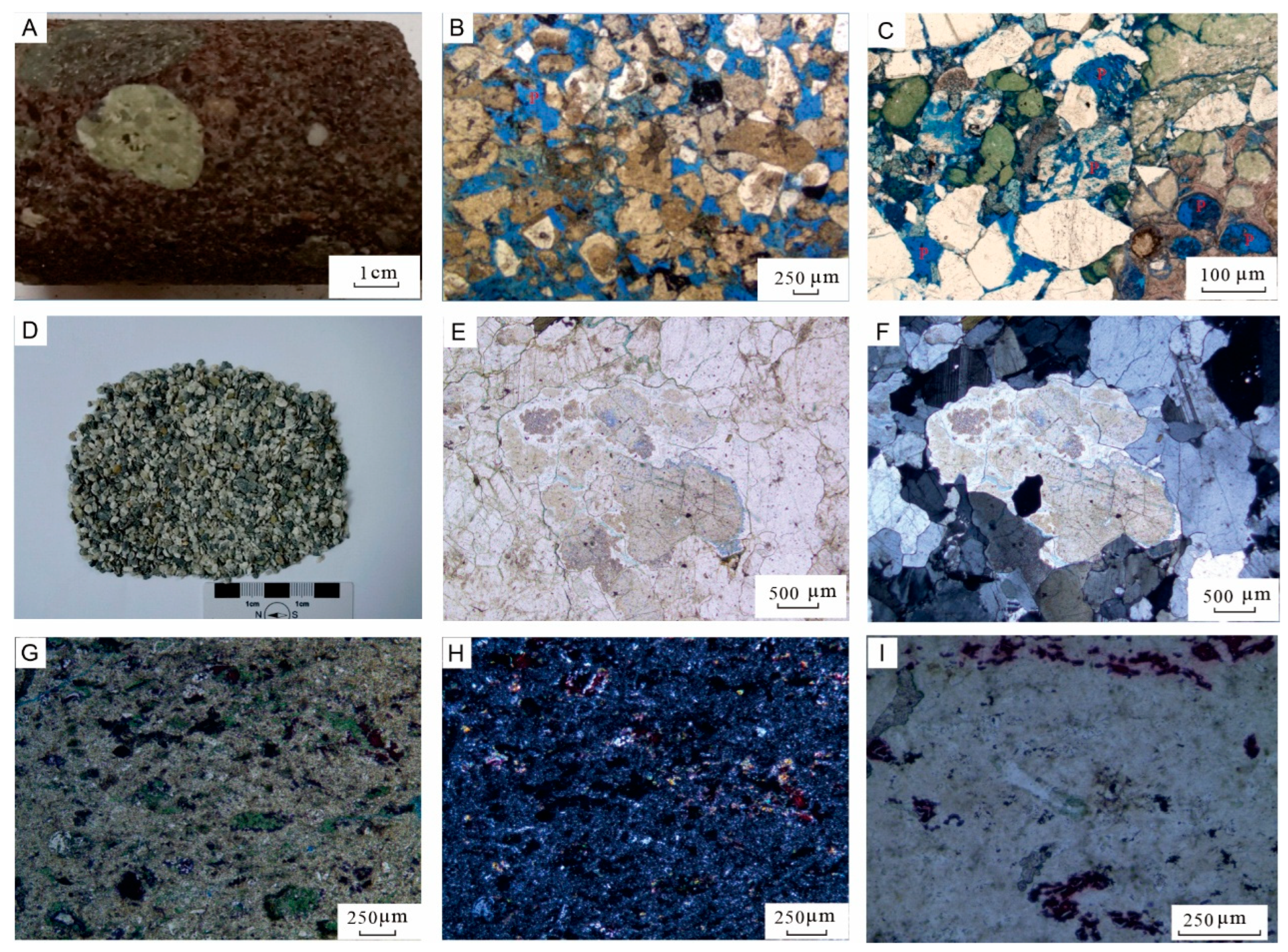
The metamorphic sandstone is mainly red-brown medium- to coarse-grained sandstone (Figure 2A). Its grain framework is primarily composed of quartz and rhyolite clasts (Figure 2B). The sandstone is characterized by poor sorting, a coarse-grained texture, and the presence of glauconite and bioclasts (Figure 2C). It is locally cemented by carbonate. Notably, glauconite is abundant, with authigenic grains filling dissolution pores. The porosity is moderately developed, with various pore types, including dissolution pores and biocavity pores.
The granite clasts are light gray (Figure 2D) and are composed of mainly medium to fine-grained granite, incorporating fine-grained diorite porphyry clasts and granite clasts (Figure 2E,F). The medium- to fine-grained granite comprises approximately 45% alkali feldspar, 35% quartz, 10% plagioclase, and 10% biotite, with plagioclase exhibiting polysynthetic twinning and biotite undergoing chloritization. The tuff is gray and exhibits a tuff texture (Figure 2G–I). It contains minor quartz and feldspar crystal fragments, banded glass fragments, and volcanic ash recrystallized into felsic minerals. The rock is generally altered to pyrite and chlorite, with volcanic ash comprising approximately 80% of its composition. Occasional fine cracks are observed within the rock.
Mineral Characteristics of Zhuhai Formation Sandstone
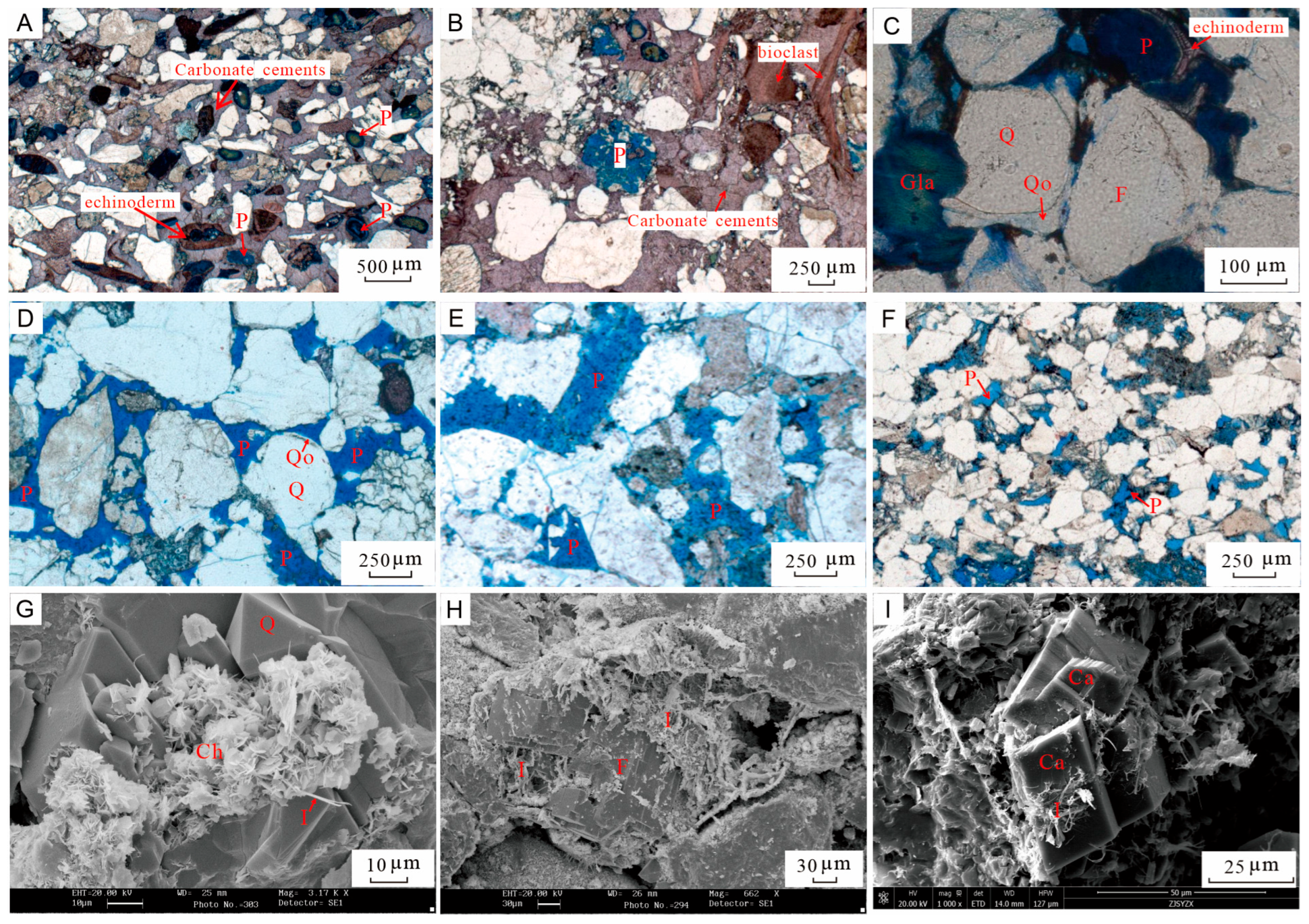
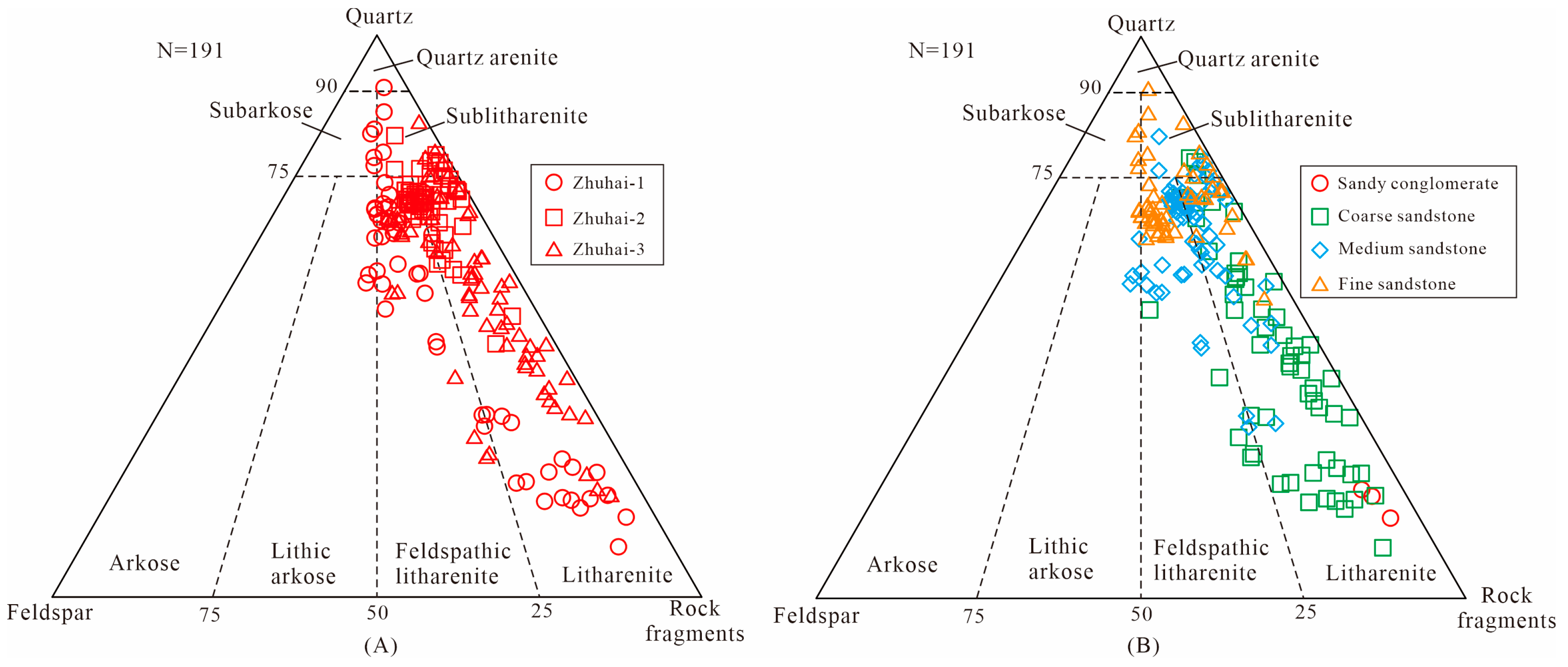
Due to variations in provenance properties and sedimentation processes, the petrological characteristics of Zhuhai formation sandstones in Wenchang A sag exhibit significant variations. Through weathering and erosion, these sandstones can form high-quality reservoirs. The sandstones are rich in quartz and rock fragments (Figure 3A), and unstable components within the rock fragments are dissolved to form the secondary pores (Figure 4E). The predominant rock types are feldspathic litharenite and litharenite. The compositional maturity averages 1.28.
The lithology of the Zhuhai Formation is dominated by coarse- to fine-grained sandstones (Figure 3B), with a high content of igneous rock debris. The petrographic components of sandstones vary with lithology (Figure 3B). Fine- to medium-grained sandstones are richer in quartz, whereas coarse-grained sandstones and sandy conglomerates contain a higher proportion of rock fragments. These variations in petrographic components among different grain sizes reflect differences in transport distance. Sediments with longer transportation distances are typically finer-grained and show higher textural and compositional maturity, resulting in a greater abundance of quartz. Cross-bedding occurs in the coarse-grained sandstones, while fine-grained sandstones exhibit parallel and wavy bedding, reflecting variations in dynamics conditions during deposition.
The cements include carbonate cements, siliceous cements, and clay minerals (Figure 4A–F), precipitated from fluids during burial diagenesis. The carbonate cements include five types: calcite, dolomite, ferrocalcite, ankerite, and siderite, with ferrocalcite and ankerite being the dominant type (Figure 4A,B).
The pore system of the Zhuhai Formation is dominated by secondary dissolution pores, which constitute 75% of the total pore area, while primary pores are less common (Figure 4C–F). Due to the high geothermal gradient and significant burial depth, the Zhuhai Formation has undergone intense diagenesis. As a result, primary intergranular pores have been extensively lost, mostly being residual intergranular pores after compaction and cementation, generally with irregular triangular or polygonal shapes. These primary pores constitute an average of 3.1% of the total rock volume (approximately 12% of the total pore area).
Dissolution pores are the main pore types of the Zhuhai Formation reservoirs, mostly formed by the dissolution of feldspar and rock fragments (Figure 4H). Honeycomb intragranular dissolution pores formed along the cleavage fractures of potassium feldspar are widespread (Figure 4H). When dissolution is more intense, entire feldspar or rock fragments are completely dissolved, forming moldic pores (Figure 4B). The intergranular dissolution contributes additional enlarged pores. Other pore types, such as matrix micropores, biocavity pores, and intercrystalline pores, are also locally developed (Figure 4G). However, these pores are typically microscopic and contribute negligibly to the overall reservoir storage capacity.

4.1.2. Paleogeomorphic Restoration

Paleogeomorphology is one of the intrinsic characteristics of a basin and a significant factor controlling the development and distribution of sedimentary facies within the basin. The paleogeomorphic features are influenced by various factors, including the regional tectonics, climate, and base level changes. Given the data availability in the study area, we adopted the backstripping method for paleogeomorphic restoration [38]. The restoration process primarily relies on seismic data, well logs, and porosity data.
Due to the influence of tectonic activity such as the first and second episodes of the Zhuqiong activity and the Nanhai activity, the study area has developed various faults and fault zones of different scales [5,6,7,8]. The tectonics control the paleogeomorphic characteristics of the basin, which in turn governs the provenance system and the distribution pattern of sand bodies [38]. Analyzing the paleogeomorphic features aids in understanding the development of the sedimentary system. Through paleogeomorphic analysis, positive (such as paleo-uplifts and paleo-bulges), negative paleogeomorphic units (such as valleys and river channels), and sediment-filled areas can be clearly identified. Positive geomorphic units can serve as provenance areas, and determine the distributary directions of water systems and valleys. Negative paleogeomorphic units are channels for sediment transport, bridges connecting provenance and sedimentary areas, and important geomorphic units that control the late development of water systems.
The Zhuhai Formation developed in the context of the gradual disappearance of lacustrine environments and the gradual transgression of seawater (NW-ward). However, as a natural barrier between the Zhu III Depression and the open sea, the Shenhu Uplift hindered communication between the Wenchang Sag and the outside open sea during this period, creating a semi-closed shallow marine sedimentary environment (Figure 1B).
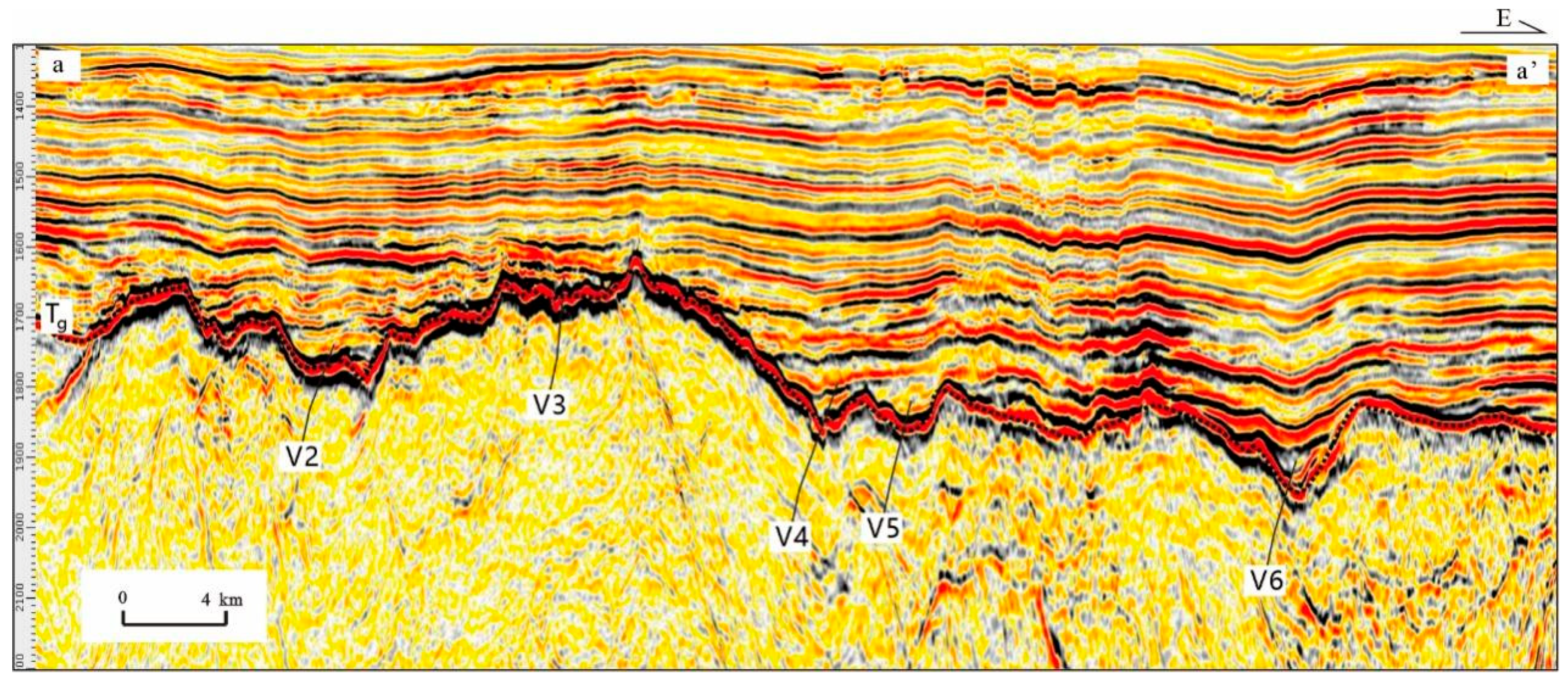
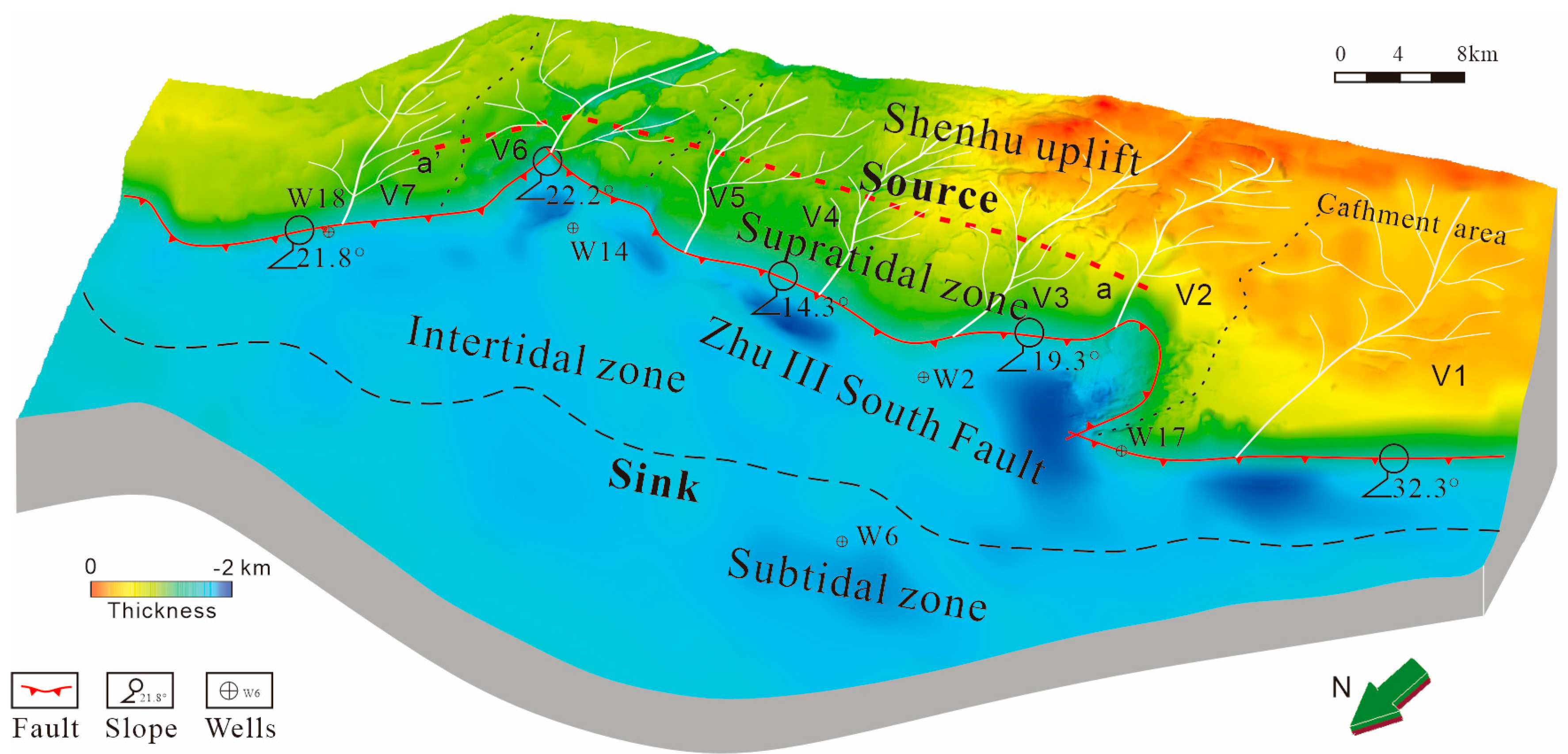
The identified valleys are named V1–V5 (Figure 5), with an average watershed area of 67.4 km2. The valleys have a U-V shape, with an average length of 2.6 km, indicating a certain provenance supply capacity. The deposition center was mainly located on the west side of A sag. The original deposition thickness at the deepest part of the depression is approximately 2000 m (Figure 6). The slope in the area near the Zhu-III fault varies significantly. Specifically, the slope in the western part is approximately 32°, in the middle part it is around 15–20°, and in the eastern part it is approximately 22°.
The initial stage of the Zhuhai Formation was in the faulted depression stage, with the sedimentary environment changing from fluvial-marsh to beach-shallow lake to semi-closed bay. The paleogeomorphic form in the study area of the Zhu III Depression underwent significant changes. At the beginning of the Zhuhai Formation sedimentation, regional tectonic activity led to regional uplift and erosion. Subsequently, the Zhu III Depression began to receive Zhuhai Formation sediments, and the Shenhu Uplift’s activity weakened. Due to the further activity of the Zhu III South Fault, a sedimentary pattern was formed in the study area with a general southward dip and northward overhang, and the sedimentary depocenter was biased towards the side of the Zhu III South Fault. The basin depth was basically between 1 km and 2 km. The deepest area was near well 6 in the Wenchang A Depression, reaching up to 2000 m. The southern boundary was the Shenhu Uplift, and the material from the Shenhu Uplift was transported in through the slope break zone. The overall shape was elliptical, with the main axis being approximately 30 km. The material sources from the central Shenhu Uplift and the eastern Shenhu Uplift could supply materials through the relatively steep southern slope, and the supply capacity was strong.

4.1.3. Paleoprovenance Restoration and Division of Source Areas and Catchment Areas

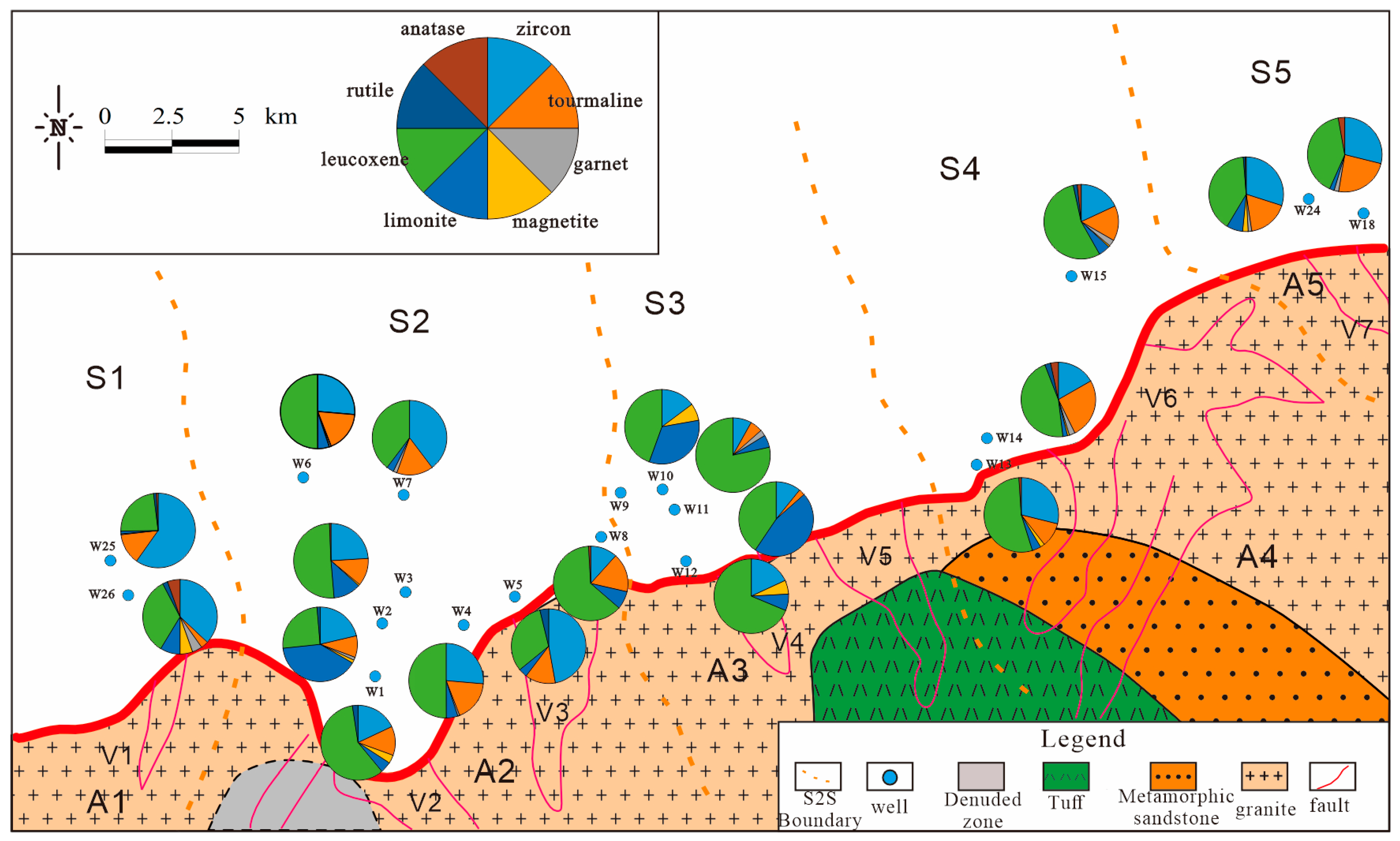
Based on the heavy mineral assemblages of the Zhuhai Formation, the catchment areas can be divided into five units: S1–S5 (Figure 7). The heavy mineral assemblage of S1–S2 is dominated by leucoxene, zircon, tourmaline, and limonite. The heavy mineral assemblage of S3 is mainly composed of leucoxene, limonite, zircon, and magnetite, while the heavy mineral assemblage of S4–S5 is dominated by leucoxene, zircon, and tourmaline. Based on paleogeomorphic and paleoprovenance analysis, the sedimentary area S1 corresponds to valley V1, and is classified as provenance area A1. Zone S2 corresponds to two valleys, V2 and V3, and is classified as provenance area A2 (Table 1). Sedimentary area S3 corresponds to two valleys, V4 and V5, and is classified as provenance area A3. Sedimentary area S4 corresponds to one valley, V6, and is classified as provenance area A4. Sedimentary area S5 corresponds to one valley, V7, and is classified as provenance area A5.

4.2. Sedimentary Facies Distribution of the Zhuhai Formation

4.2.1. Types of Sedimentary Facies

Within the semi-enclosed shallow marine depositional environment, two types of sedimentary facies, fan delta and tidal flat, have been identified. These can be distinguished through lithological associations, sedimentary structures, well log patterns, and seismic reflection characteristics. The following sections provide a detailed description and interpretation of each facies.
Fan Delta
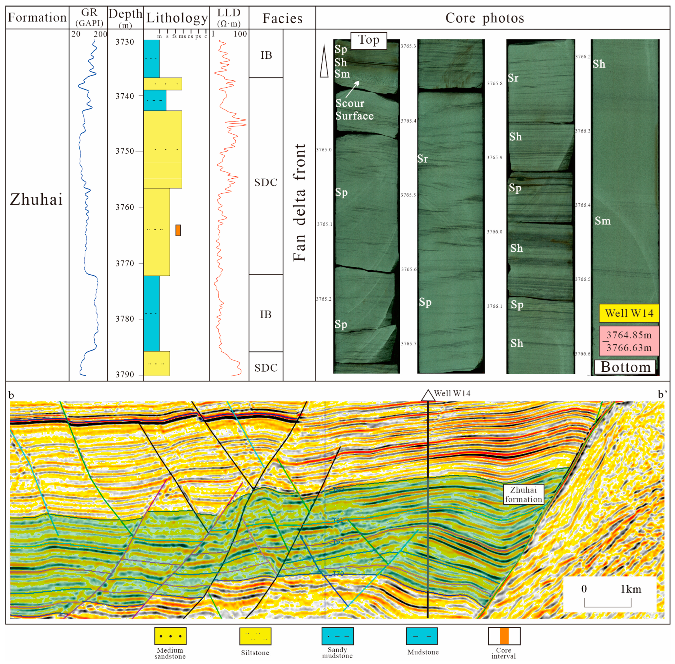
Description: The lithological association is characterized by conglomeratic sandstone and coarse- to fine-grained sandstone interbedded with thin layers of mudstone (Figure 8). In the core from well W14, the sandstones are gray to light gray, predominantly medium- to fine-grained, and commonly exhibit massive bedding, parallel bedding, and tabular cross-bedding. Erosional surfaces are typically developed at the base, with the grain size of the sediment fining upwards from the erosional surface. Additionally, the Gamma Ray (GR) log exhibits a box-shaped pattern. On seismic reflection profiles, this facies is wedge-shaped and marked by low amplitude and chaotic reflections.
Interpretation: Based on the depositional environment, lithological association, sedimentary structures, and wedge-shaped chaotic seismic facies, we interpret this deposit as a fan delta. The fan delta front sand bodies are mainly developed. The thick strata of medium- to fine-grained sandstone found in well 14 are interpreted as deposits of subaqueous distributary channels on the fan delta front (Figure 8), whereas the thick intervals of mudstone are regarded as deposits of interdistributary bays.
Tidal Flat
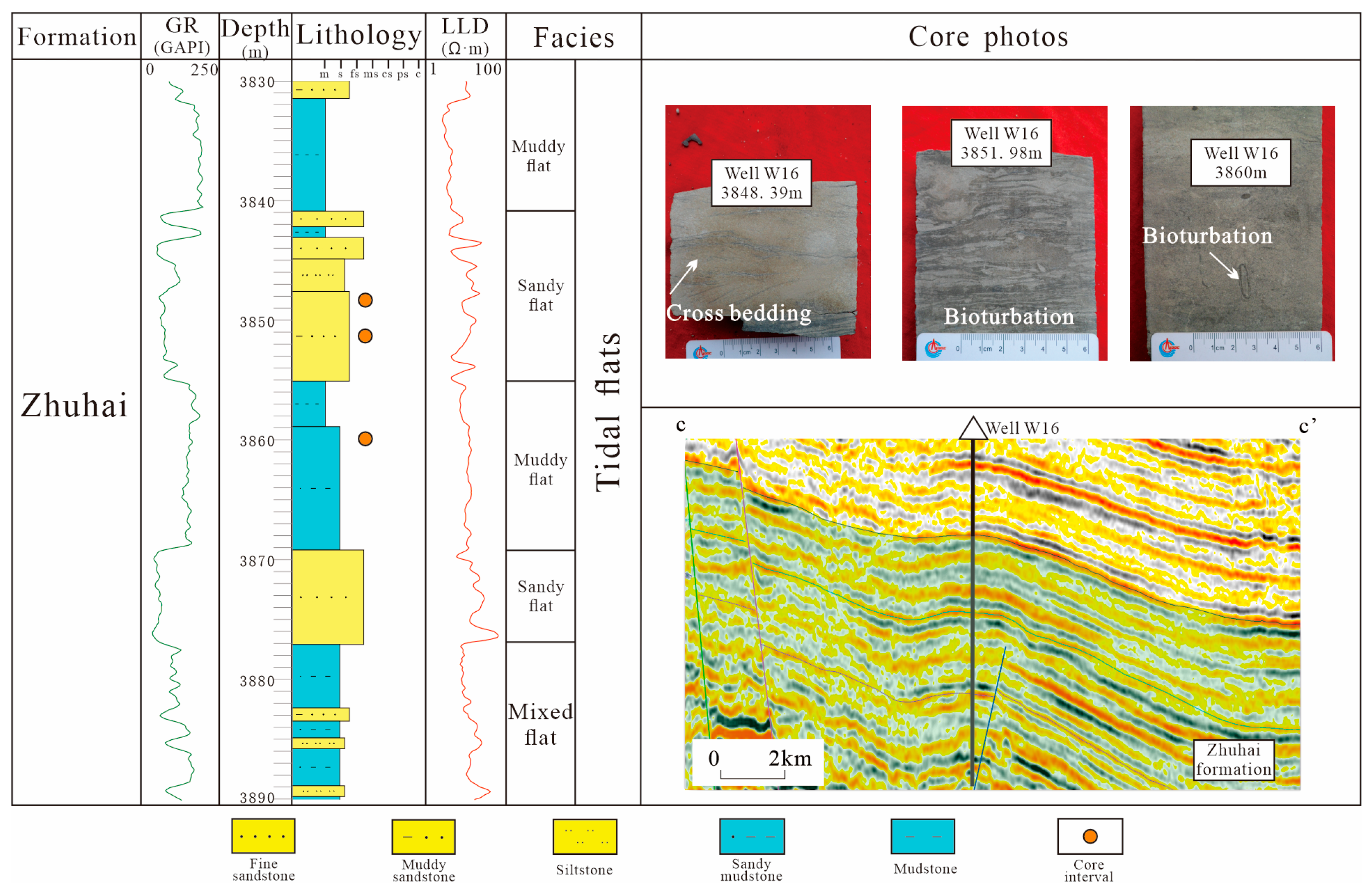
Description: The lithological association is predominantly composed of fine- grained sandstone, muddy fine- grained sandstone, muddy siltstone, silty mudstone, and mudstone (Figure 9). Core from well W16 is gray to grayish-black sandstones with well-developed muddy bands and a variety of sedimentary structures, including flaser bedding, lenticular bedding, tidal bundle bedding, and parallel bedding. Bioturbation structures and herringbone cross-bedding are common, and plant roots and stems are visible. Logging interpretation reveals extensive mudstone interbedded with sandstone, with overall low GR values and a curve combining serrated box-shaped and finger-like patterns. On seismic profiles, it is characterized by medium amplitude, low frequency, and poorly continuous parallel to sub-parallel seismic facies.
Interpretation: During the deposition of the Zhuhai Formation, the Pearl River Mouth Basin was in a stage of fault-depression-to-depression transition, with intensified marine transgression. This alteration in the depositional environment created favorable conditions for the development of coastal tidal flats. The primary hydrodynamic force was tidal, and the herringbone cross-bedding reflects the alternating erosion of sediments by bidirectional currents. The tidal flat facies can be further subdivided into sand flat, mud flat, and mixed flat.

4.2.2. Facies Distribution

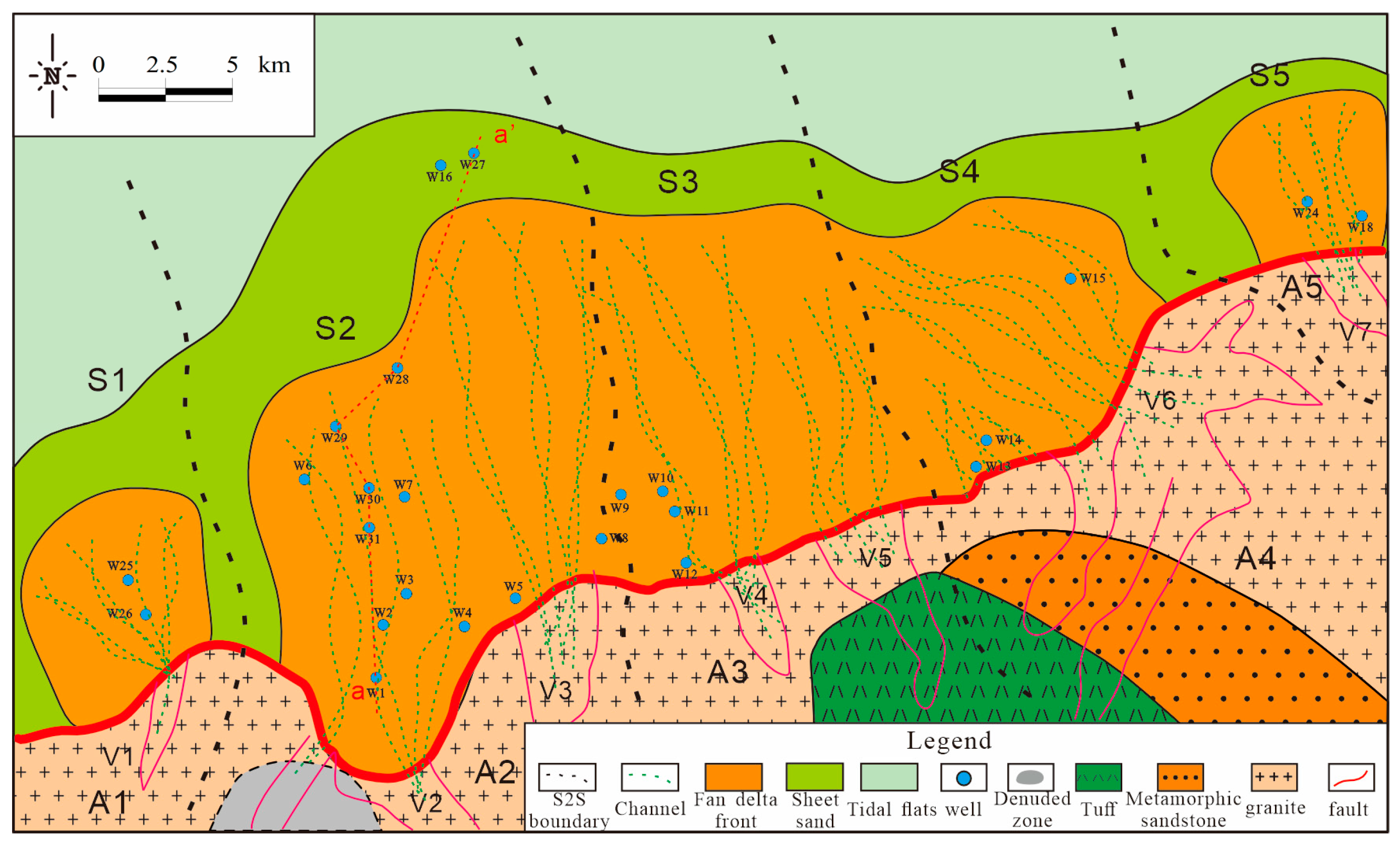
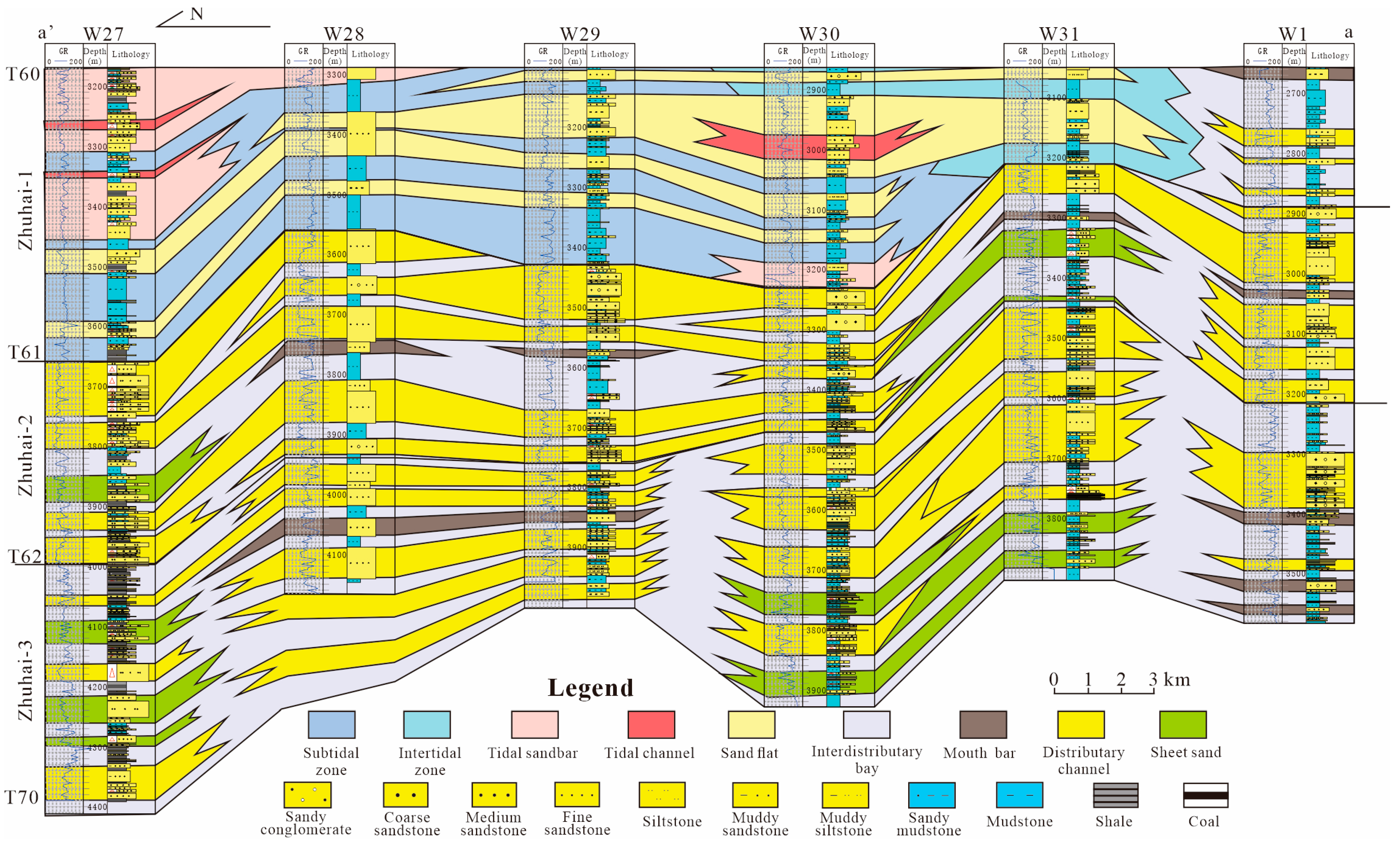
Following the Paleogene, a continuous rise in sea level connected the Zhu III Depression to the open ocean, establishing a wave-controlled coastal depositional regime [9]. The tidal flat–fan delta depositional system of the Zhuhai Formation exhibits a distinct spatial and temporal distribution of facies belts. Fan deltas primarily develop near the edge of the Shenhu Uplift, where sediment supply is abundant and transport distance is short, favoring the development of fan delta deposits. In contrast, coastal tidal flats are distributed in areas farther from the provenance zone with gentler slopes (Figure 10). Relative to the Zhu III South Fault, the fan deltas are interpreted as footwall-derived systems that prograde towards the hanging wall, where the tidal flats were deposited. Seismic amplitude slices provide crucial petrological and geomorphological information for sedimentary facies analysis. We have selected typical stratigraphic slices from the third to the first members of the Zhuhai Formation to reveal the spatial and temporal distribution of fan delta and tidal flat facies (Figure 11).
A complete sea-level cycle, characterized predominantly by transgressive and highstand systems tracts, can be identified in the third member of the Zhuhai Formation (Figure 11). During the rapid sea-level fall stage of the highstand systems tract, erosion in the provenance area intensifies, driving sediments farther into the basin and causing sand bodies to prograde seaward. The fan delta in the Wenchang A sag of the third member of the Zhuhai Formation extends over a large area, generally in a fan shape, with an extension distance of approximately 18 km and an area of about 540 km2. Lagoonal deposits develop around the fan body. The extensive extension and distribution of the fan delta reflect the strong sediment supply capacity of the Shenhu Uplift in the south, indicating continuous activity and erosion of the Shenhu Uplift.

5. Discussion

5.1. Relationship Between Source-to-Sink System and Depositional Facies

The scale of sedimentary bodies is characterized by the distribution area of fan deltas and their extension distance towards the lacustrine basin [11]. That is, the larger the sand body area and the greater the extension distance, the stronger the sediment transport capacity and the larger the scale of the sedimentary body [12].
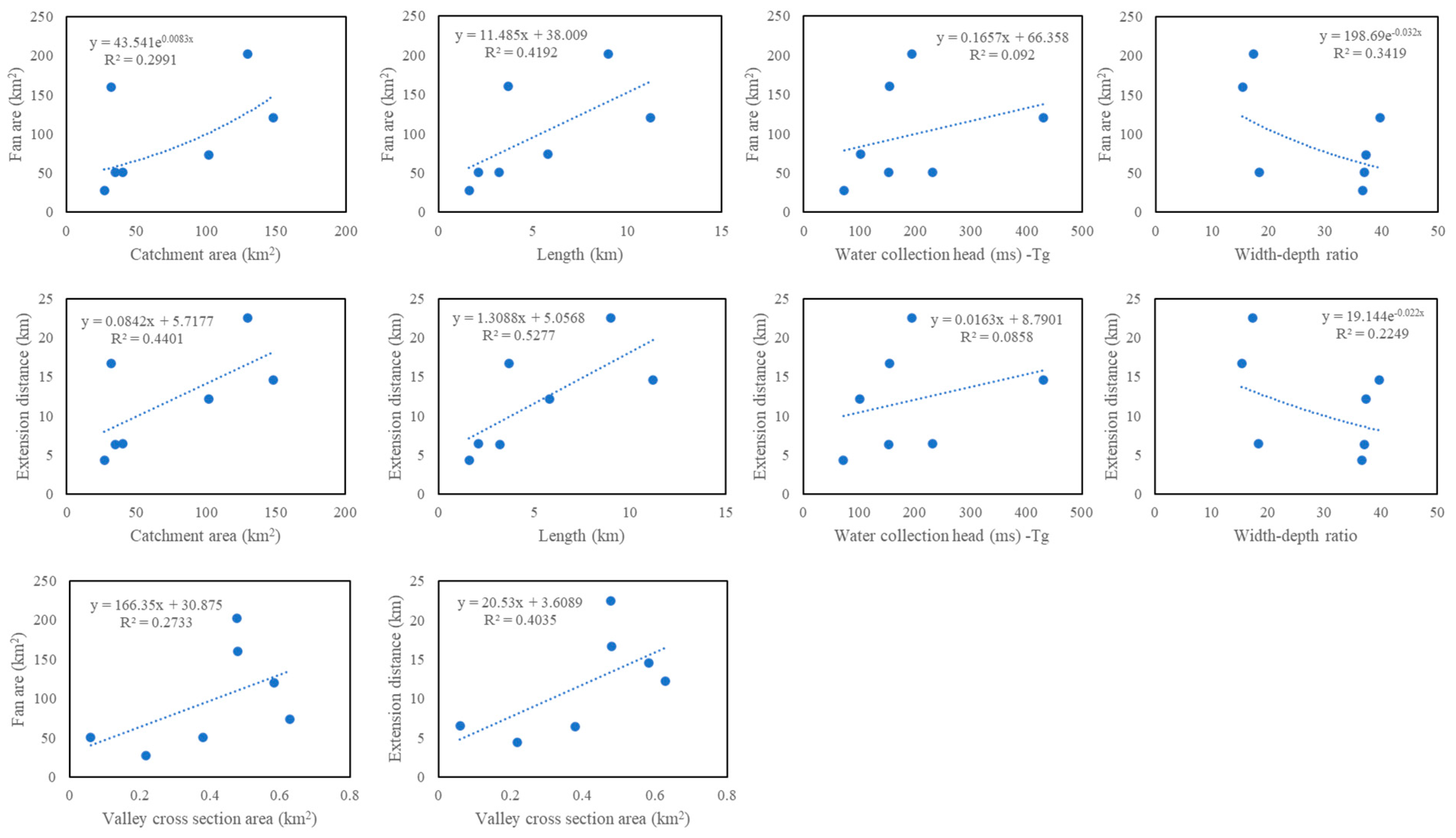
The results of single-factor correlation analysis are between the catchment area of the source region, the elevation difference in water collection, the length of valleys, the cross-sectional area of valleys, the width-to-depth ratio of valleys, and the sand body area and extension distance. The results show that the catchment area, valley length, and valley cross-sectional area are all strongly and positively correlated with the scale of the sedimentary system (Figure 12). A larger catchment area and longer valley length result in greater erosion of the provenance, while a larger valley cross-sectional area reflects stronger sediment transport capacity and higher transport velocities, leading to a more developed sedimentary system. A greater elevation difference in water collection leads to higher potential energy for sediment transport, while a smaller width-to-depth ratio indicates stronger hydrodynamic forces, both of which contribute to a larger area of sedimentary sand bodies and a more developed sedimentary system.
The slope of the Shenhu uplift ranges from 25° to 45°, with a significant elevation difference in the source region (108–646 m), a large catchment unit area (27–148 km2), strong hydrodynamic forces, numerous valleys with relatively long lengths (1.6–11.2 km), small cross-sectional areas (0.06–0.62 km2), predominantly “V”-shaped valleys, and a width-to-depth ratio of 15 to 39. These characteristics facilitate the transport of large amounts of sediment from the catchment into the lake. The descending limb of the steep slope fault, controlled by large-scale Zhu III South Fault, provides sufficient accommodation space, allowing sediment to accumulate nearby to form fan delta sand bodies. These fan bodies are relatively large in area (28–160 km2), wide in the transverse direction, and extend longitudinally over long distances (4.4–22.5 km).

5.2. Valley-Tidal Coupled Control on Clastic Sediment Distribution

During the depositional process of the Zhuhai Formation, sediments of varying grain sizes and compositions were deposited alternately in space and time under the influence of tidal action, river input, and transgression [9]. The deposition of the Zhuhai Formation was significantly affected by regional tectonic evolution, the S2S system, and hydrodynamics [16,17].
The provenance primarily originated from the southern Shenhu Uplift. These sediments transported to the depositional area via source-area valleys (V1–V7), providing the material basis for the Zhuhai formation. The abundance of the sediments and the transport distance influenced the grain size, sorting, and mineral composition [15]. Sandstones proximal to the southern fault zone are characterized by relatively low quartz and feldspar content and coarser grain sizes.
The drainage units A2–A4 served as the primary source areas, while the incised valleys (V1–V7) govern the direction of sediment supply. Tectonic subsidence along the southern boundary fault and fluctuations in base level have significantly shaped the accommodation space and the evolutionary trajectory of depositional infill within the subsiding region [40]. From the third member to the first member of the Zhuhai Formation, the fan deltas underwent a transformation: they evolved from the thickest, large-scale, prograding, and overlapping fan deltas to the thinnest, small-scale, retrograding fan deltas.
Overlapping fan deltas of varying scales are located at the foot of the southern fault, corresponding to catchment units (S1–S5) and transported through channels V1–V7. The fan deltas exhibit distinct areas: S1 (51.4 km2), S2 (362 km2), S3 (101 km2), S4 (121 km2), and S5 (51.2 km2). The largest-scale sediment transport occurred in the A2–S2 unit, forming a large-scale sand body, whereas the smallest-scale sand body developed in the A5–S5 unit, with medium-scale sand bodies in the other units.
Quantitative characterization of the “source” includes bedrock nature, catchment area, and catchment relief. The catchment area determines the magnitude of ancient water flow and serves as an effective carrier for transporting sediments, influencing the rate of sediment supply. The catchment relief determines the potential energy for sediment transport and is the primary driving force for large-scale sediment movement.
Valleys are morphologically classified into V-shaped and U-shaped valleys. When they are close to the provenance and have strong hydrodynamic conditions, they have sufficient sand-carrying capacity and tend to form V-shaped valleys. With increasing transport distance, hydrodynamic energy weakens and slopes decrease, generally leading to the development of U-shaped valleys. Quantitative characterization of the “sink” includes the morphology, area, thickness, and extension distance of the deposited sand bodies.
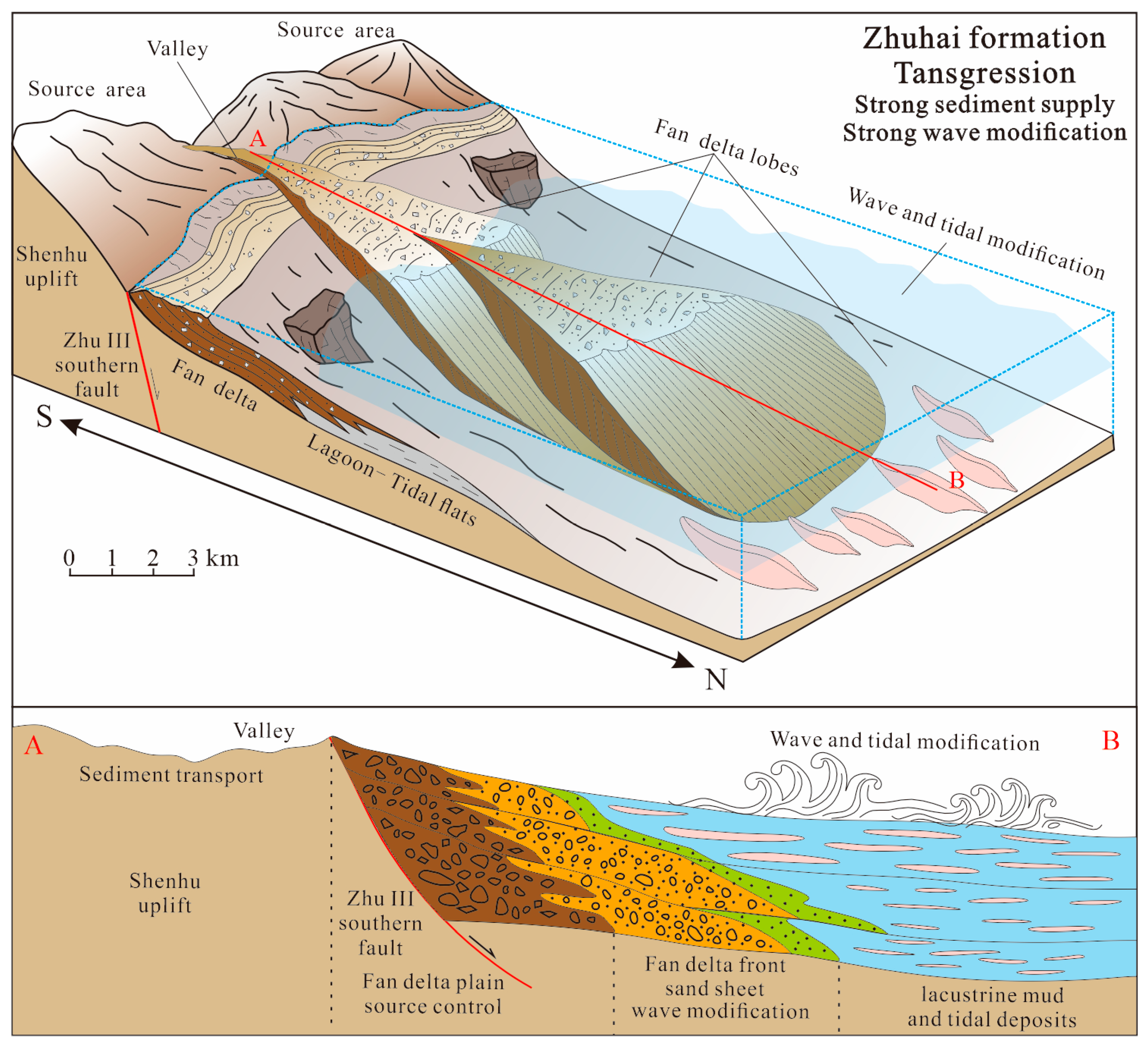
Within the depositional-subsidence zone, the scale and spatial distribution of the fan delta system are primarily governed by the tectonic margin configuration and the dynamic interplay between the associated accommodation space (dictated by tectonic subsidence rates) and sediment supply dynamics (Figure 13). The evolutionary dynamics and depositional infill patterns in the study area are influenced by paleoclimatic variations and base-level fluctuations. Fluctuations in base level primarily shape the fan delta system through two key mechanisms: (1) Increasing or decreasing the drainage or catchment area and influencing the prograding or retrograding patterns of sediment supply; and (2) controlling the depositional position of the fan deltas and the concentration of sandy reservoirs near the interface. Higher tectonic subsidence rates, larger catchment areas, and deeper valleys generally result in the formation of larger fan deltas.

6. Conclusions

(1)
The basement lithology of the Shenhu Uplift in the southern part of the Wenchang A sag primarily comprises granite, Mesozoic sandstone, and tuff. The lithology of the Zhuhai Formation in the study area is dominated by feldspathic litharenite and litharenite, which are rich in quartz and rock fragments.
(2)
The Zhuhai Formation in the study area can be divided into five paleogeographic zones (S1–S5), and units S2–S4 are the primary sedimentary area. Zone S2 corresponds to two valleys (V2 and V3) and provenance area A2. Zone S3 corresponds to two valleys (V4 and V5) and provenance area A3. Zone S4 corresponds to one valley (V6) and provenance area A4.
(3)
The scale of sedimentary bodies is strongly positively correlated with catchment area, valley length, and valley cross-sectional area, as these factors enhance sediment transport capacity.
(4)
The sandstones within the tidal flat-fan delta system were strongly reworked by waves and exhibit high-quality reservoirs and form favorable reservoir–cap combinations with the overlying transgressive mudstone caprocks, which are conducive to the preservation and accumulation of hydrocarbon.

Author Contributions

Conceptualization, M.L., Y.M., L.W., S.X., J.Z. and D.Z.; Methodology, M.L., Y.M., L.W., S.X. and D.Z.; Software, L.W.; Investigation, L.W., Y.C. and J.Z.; Resources, M.L., S.X., J.Z. and D.Z.; Writing—original draft, M.L., Y.M., L.W., Y.C., J.Z. and D.Z.; Visualization, L.W., Y.C. and S.X.; Supervision, M.L., Y.M., S.X., J.Z. and D.Z.; Project administration, Y.M.; Funding acquisition, M.L. and Y.M. All authors have read and agreed to the published version of the manuscript.

Funding

This research was funded by the National Science and Technology Special Project (No. 2025ZD1402805-01), the CNOOC Limited Scientific Research Project: Hydrocar-bon Enrichment Patterns and Exploration Targets in Steep-Slope Sand-Gravel Rock Zones of the Shallow-Water Area in the Pearl River Mouth Basin (No. KJZH-2024-2106), and the Study on Tectonic Restoration and Hydrocarbon Accumulation Patterns in the Zhu III Depression (No. ZYKY-2025-ZJ-04).

Data Availability Statement

The data presented in this study are available on request from the corresponding author. The data are not publicly available due to the company policy.

Acknowledgments

We sincerely appreciate the professional guidance provided by Academic Editor Georgia Pe-Piper and Assistant Editor Keely Luo, as well as the constructive feedback from the reviewers, which has greatly improved our manuscript.

Conflicts of Interest

All authors received funding support from China National Offshore Oil Corporation Limited. The funding sponsors had no role in the design of the study; in the collection, analyses, or interpretation of data; in the writing of the manuscript, and in the decision to publish the results.

References

  1. Zhang, J.; Konstantinovskaya, E.; Wu, Z.; Cheng, Y.; Xu, B. A prospect analysis of the Upper Oligocene sandstone reservoirs of the Wenchang 9 block, Pearl River Mouth Basin, northern South China Sea margin. Mar. Pet. Geol. 2024, 160, 106613. [Google Scholar] [CrossRef]
  2. Jia, W.; Zong, Z.; Qin, D.; Lan, T. Integrated well-log data and seismic inversion results for prediction of hydrocarbon source rock distribution in W segment, Pearl River Mouth Basin, China. Geoenergy Sci. Eng. 2023, 230, 212233. [Google Scholar] [CrossRef]
  3. Wang, C.; Chen, D.; Li, H.; Chang, S.; Liu, Z.; Wang, F.; Wang, Q. Differential Genetic Mechanisms of Deep High-Quality Reservoirs in the Paleogene Wenchang Formation in the Zhu-1 Depression, Pearl River Mouth Basin. Energies 2022, 15, 3277. [Google Scholar] [CrossRef]
  4. Wu, D.; Li, H.; Jiang, L.; Hu, S.; Wang, Y.; Zhang, Y.; Liu, Y. Diagenesis and reservoir quality in tight gas bearing sandstones of a tidally influenced fan delta deposit: The Oligocene Zhuhai Formation, western Pearl River Mouth Basin, South China Sea. Mar. Pet. Geol. 2019, 107, 278–300. [Google Scholar] [CrossRef]
  5. Pinglu, L.; Chuntao, R. Tectonic characteristics and evolution history of the Pearl river mouth basin. Tectonophysics 1994, 235, 13–25. [Google Scholar] [CrossRef]
  6. Yan, P.; Deng, H.; Liu, H.; Zhang, Z.; Jiang, Y. The temporal and spatial distribution of volcanism in the South China Sea region. J. Asian Earth Sci. 2006, 27, 647–659. [Google Scholar] [CrossRef]
  7. Ding, W.; Sun, Z.; Mohn, G.; Nirrengarten, M.; Tugend, J.; Manatschal, G.; Li, J. Lateral evolution of the rift-to-drift transition in the South China Sea: Evidence from multi-channel seismic data and IODP Expeditions 367&368 drilling results. Earth Planet. Sc. Lett. 2020, 531, 115932. [Google Scholar] [CrossRef]
  8. Wang, Q.; Zhao, M.; Zhang, J.; Zhang, H.; Sibuet, J.-C.; Li, Z.; He, E.; Qiu, X.; Peng, W.; Chen, G. Breakup mechanism of the northern South China Sea: Evidence from the deep crustal structure across the continent-ocean transition. Gondwana Res. 2023, 120, 47–69. [Google Scholar] [CrossRef]
  9. Qiao, P.; Cui, Y.; Ma, Q.; Yu, Q.; Shao, L. Paleogene transgression process and environmental evolution in the deepwater area of the Baiyun Depression in the northern South China Sea. Acta Oceanol. Sin. 2024, 43, 15–24. [Google Scholar] [CrossRef]
  10. Wang, C.; Wen, S.; Liang, X.; Shi, H.; Liang, X. Detrital zircon provenance record of the Oligocene Zhuhai Formation in the Pearl River Mouth Basin, northern South China Sea. Mar. Pet. Geol. 2018, 98, 448–461. [Google Scholar] [CrossRef]
  11. Liu, Q.; Zhu, X.; Zeng, H.; Li, S. Source-to-sink analysis in an Eocene rifted lacustrine basin margin of western Shaleitian Uplift area, offshore Bohai Bay Basin, eastern China. Mar. Pet. Geol. 2019, 107, 41–58. [Google Scholar] [CrossRef]
  12. Liu, Y.; Huang, S.; Wang, D.; Li, N.; Yin, Y.; Chen, Y.; Li, Z. Astronomical influence of the development of Paleogene thin coal seam groups in offshore Lacustrine basins: A case study of the Zhu I Depression’s Enping Formation located in the northern South China Sea. Acta Oceanol. Sin. 2024, 43, 136–150. [Google Scholar] [CrossRef]
  13. Liu, Q.; Zhu, X.; Zhou, Z.; Bao, Y.; Shi, W. Provenance identification and source-to-sink studies from an intrabasinal subaqueous uplift in the Eocene western Bohai Bay Basin, eastern north China. Mar. Pet. Geol. 2023, 149, 106087. [Google Scholar] [CrossRef]
  14. Zhang, W.; Xian, B.; Ji, H.; Zhang, X.; Xiao, Z.; Wang, Z.; Wang, J.; Chen, L.; Lian, H.; Wu, Q.; et al. Magmatic intrusion impacts on source-to-sink system of rift basins: Eocene Lufeng-22 sub-sag, Pearl River Mouth Basin, South China Sea. J. Asian Earth Sci. 2022, 240, 105440. [Google Scholar] [CrossRef]
  15. Li, Z.; Liu, Q.; Zhu, H.; Zhang, X.; Li, M.; Zhao, Q. Compositional relationship between the source-to-sink segments and their sedimentary response to diverse geomorphology types in the intrabasinal lower uplift of continental basins. Mar. Pet. Geol. 2021, 123, 104716. [Google Scholar] [CrossRef]
  16. Xue, X.; Storms, J.; Zăinescu, F.; Schuster, M.; Wang, L.; May, J.H.; Ng, Z.L.; van der Vegt, H.; Nutz, A.; Bozetti, G.; et al. Wind-driven hydrodynamic and depositional patterns in shallow lakes: An exploratory modelling approach based on an archetypal case of Lake Hulun. Sedimentology 2025, 72, 1040–1064. [Google Scholar] [CrossRef]
  17. Wang, L.; Schuster, M.; Xin, S.-W.; Zainescu, F.; Xue, X.-Y.; Storms, J.; May, J.-H.; Nutz, A.; van der Vegt, H.; Bozetti, G.; et al. Littoral landforms of Lake Hulun and Lake Buir (China and Mongolia): Wind-driven hydro-sedimentary dynamics and resulting clastics distribution. J. Palaeogeogr. 2024, 13, 309–326. [Google Scholar] [CrossRef]
  18. Wang, L.; Jiang, Z.; Xin, S.; Schuster, M. Depositional model, facies analysis and reservoir quality in a wave-modified clastic lacustrine system: The early cretaceous Tongbomiao formation of the Tanan Depression, Tamtsag Basin, Mongolia. Geoenergy Sci. Eng. 2023, 227, 211886. [Google Scholar] [CrossRef]
  19. Zhou, X.; Lidong, S. Factors controlling the formation and evolution of source rocks in the Shahezi Formation, Xujiaweizi fault depression, Songliao Basin. Energy Geosci. 2022, 4, 100140. [Google Scholar] [CrossRef]
  20. Su, K.; Chen, S.; Hou, Y.; Lu, Z.; Shao, X.; Li, S.; Li, Y.; Zhu, J.; Han, M. Application of factor analysis to investigating molecular geochemical characteristics of organic matter and oil sources: An exploratory study of the Yanchang Formation in the Ordos Basin, China. J. Pet. Sci. Eng. 2022, 208, 109668. [Google Scholar] [CrossRef]
  21. Yongqiang, Q.; Jianguo, P.; Lu, Y.; Duonian, X.; Tuanyu, T.; Guodong, W. Identification of favorable underwater reservoirs in a conglomerate fan delta. Geoenergy Sci. Eng. 2023, 221, 111307. [Google Scholar] [CrossRef]
  22. Deng, Q.; Hu, M.; Wang, N.; Song, P.; Zeng, F.; Ibrahima Kane, O.; Cai, Q. High-quality sandstone reservoir evaluation and prediction in a half-graben rift sag under the influence of igneous intrusions, Songliao Basin, Northeast China. Geoenergy Sci. Eng. 2023, 225, 211665. [Google Scholar] [CrossRef]
  23. Drake, N.A.; Candy, I.; Breeze, P.; Armitage, S.J.; Gasmi, N.; Schwenninger, J.L.; Peat, D.; Manning, K. Sedimentary and geomorphic evidence of Saharan megalakes: A synthesis. Quat. Sci. Rev. 2022, 276, 107318. [Google Scholar] [CrossRef]
  24. Zurbuchen, J.; Simms, A.R.; Warrick, J.A.; Miller, I.M.; Ritchie, A.; Bristow, C. A model for the growth and development of wave-dominated deltas fed by small mountainous rivers: Insights from the Elwha River delta, Washington. Sedimentology 2020, 67, 2310–2331. [Google Scholar] [CrossRef]
  25. Peng, Y.; Olariu, C.; Steel, R.J. Recognizing tide- and wave-dominated compound deltaic clinothems in the rock record. Geology 2020, 48, 1149–1153. [Google Scholar] [CrossRef]
  26. Olivo, M.S.; Kietzmann, D.A.; Schencman, L.J.; Minisini, D.; Espínola, J.; Waldmann, N.D. Characterizing scales of sedimentary heterogeneity in a fluvial—Estuarine reservoir analog: An example from the Mulichinco Formation, Neuquén Basin, Argentina. Mar. Pet. Geol. 2020, 121, 104604. [Google Scholar] [CrossRef]
  27. Okunuwadje, S.E.; Bowden, S.A.; Macdonald, D.I.M. Diagenesis and reservoir quality in high-resolution sandstone sequences: An example from the Middle Jurassic Ravenscar sandstones, Yorkshire CoastUK. Mar. Pet. Geol. 2020, 118, 104426. [Google Scholar] [CrossRef]
  28. Odino-Barreto, A.L.; Richiano, S.; Gingras, M.K.; Poiré, D.G. Integration of sedimentological and ichnological analysis on the wave-dominated deposits of The Maastrichtian Calafate Formation, Austral-Magallanes Basin, Argentina. Mar. Pet. Geol. 2020, 121, 104621. [Google Scholar] [CrossRef]
  29. Kataoka, K.S.; Nagahashi, Y.; McArthur, A. From sink to volcanic source: Unravelling missing terrestrial eruption records by characterization and high-resolution chronology of lacustrine volcanic density flow deposits, Lake Inawashiro-ko, Fukushima, Japan. Sedimentology 2019, 66, 2784–2827. [Google Scholar] [CrossRef]
  30. Han, Y.; Horsfield, B.; Mahlstedt, N.; Wirth, R.; Curry, D.J.; LaReau, H. Factors controlling source and reservoir characteristics in the Niobrara shale oil system, Denver Basin. AAPG Bull. 2019, 103, 2045–2072. [Google Scholar] [CrossRef]
  31. Chen, G.; Gang, W.; Liu, Y.; Wang, N.; Guo, Y.; Zhu, C.; Cao, Q. High-resolution sediment accumulation rate determined by cyclostratigraphy and its impact on the organic matter abundance of the hydrocarbon source rock in the Yanchang Formation, Ordos Basin, China. Mar. Pet. Geol. 2019, 103, 1–11. [Google Scholar] [CrossRef]
  32. Cai, L.; Xiao, G.; Guo, X.; Wang, J.; Wu, Z.; Li, B. Assessment of Mesozoic and Upper Paleozoic source rocks in the South Yellow Sea Basin based on the continuous borehole CSDP-2. Mar. Pet. Geol. 2019, 101, 30–42. [Google Scholar] [CrossRef]
  33. Mastalerz, M.; Drobniak, A.; Stankiewicz, A.B. Origin, properties, and implications of solid bitumen in source-rock reservoirs: A review. Int. J. Coal Geol. 2018, 195, 14–36. [Google Scholar] [CrossRef]
  34. Amin, I.E.; Jacobs, A.M. Accounting for sediment sources and sinks in the linear regression analysis of the suspended sediment load of streams: The Rio Puerco, New Mexico, as an example. Environ. Geosci. 2007, 14, 1–14. [Google Scholar] [CrossRef]
  35. Syvitski, J.P.M.; Milliman, J.D. Geology, Geography, and Humans Battle for Dominance over the Delivery of Fluvial Sediment to the Coastal Ocean. J. Geol. 2007, 115, 1–19. [Google Scholar] [CrossRef]
  36. Prizomwala, S.P.; Bhatt, N.; Basavaiah, N. Provenance discrimination and Source-to-Sink studies from a dryland fluvial regime: An example from Kachchh, western India. Int. J. Sediment. Res. 2014, 29, 99–109. [Google Scholar] [CrossRef]
  37. Su, M.; Hsiung, K.-H.; Zhang, C.; Xie, X.; Yu, H.-S.; Wang, Z. The linkage between longitudinal sediment routing systems and basin types in the northern South China Sea in perspective of source-to-sink. J. Asian Earth Sci. 2015, 111, 1–13. [Google Scholar] [CrossRef]
  38. Liu, Q.; Zhu, H.; Shu, Y.; Zhu, X.; Yang, X.; Chen, L.; Tan, M.; Geng, M. Provenance identification and sedimentary analysis of the beach and bar systems in the Palaeogene of the Enping Sag, Pearl River Mouth Basin, South China Sea. Mar. Pet. Geol. 2016, 70, 251–272. [Google Scholar] [CrossRef]
  39. Nyberg, B.; Howell, J.A. Global distribution of modern shallow marine shorelines. Implications for exploration and reservoir analogue studies. Mar. Pet. Geol. 2016, 71, 83–104. [Google Scholar] [CrossRef]
  40. Quan, Y.; Hao, F.; Liu, J.; Zhao, D.; Tian, J.; Wang, Z. Source rock deposition controlled by tectonic subsidence and climate in the western Pearl River Mouth Basin, China: Evidence from organic and inorganic geochemistry. Mar. Pet. Geol. 2017, 79, 1–17. [Google Scholar] [CrossRef]
Figure 2. (A) Pebbly grained sandstone, well 19, 2174 m, basement; (B) metasandstone, well 19, 2174 m (−), basement; (C) sandstone containing chlorite, well 20, 2220 m (−), basement (~164 Ma) (−); (D) granite rock fragments, well 21, 1740–1755 m, basement; (E) granite, well 22, 1476 m (−), basement; (F) granite, well 22, 1476 m (+), basement (~110 Ma); (G) tuff, well 23, 2234 m (−), basement; (H) tuff, well 23, 2234 m (+), basement; (I) tuff, well 23, 2230 m (−), basement (~156 Ma). P: pores.
Minerals 16 00057 g002
Figure 3. Detrital composition of sandstones based on stratigraphic classification (A) and lithological classification (B).
Minerals 16 00057 g003
Figure 4. (A) Echinoderm and ferrocalcite cements, well W16, 3603.5 m, ZH2 (−); (B) dissolution of feldspar, ferrocalcite cements, W14, 3623.2 m, ZH2 (−); (C) dissolution of feldspar, quartz overgrowth, W14, 3613 m, ZH2 (−); (D) intergranular pores, well W16, 3623 m, ZH2 (−); (E) intergranular pores, well W17, 3764.06 m, ZH3 (−); (F) intergranular pores and dissolution pores, well W4, 3681 m, ZH3 (−); (G) quartz overgrowth, chlorite, illite, W14, 3754.31 m, ZH3 (SEM); (H) dissolved feldspar, illite, W14, 3752.49 m, ZH3 (SEM); (I) calcite cements, W16, 3770 m, ZH2 (SEM); Q: quartz, P: pores, Gla: glauconite, Qo: quartz overgrowth, F: feldspar, Ch: chlorite, I: illite, Ca: calcite.
Minerals 16 00057 g004
Figure 5. Distribution map of valleys in a-a′ seismic profile; see Figure 6 for profile location (red breakpoint dots), Tg: basin basement.
Minerals 16 00057 g005
Figure 6. Paleogeomorphic map of the Zhuhai Formation in the Wenchang A sag; see a-a′ seismic profile in Figure 5; V1–V7: valleys distributed on the basement.
Minerals 16 00057 g006
Figure 7. Distribution of heavy minerals of the southern steep slope zone of the A sag; please see S2S parameters (A, S, V) in Table 1.
Minerals 16 00057 g007
Figure 8. The fan delta characteristics of the Zhuhai Formation. Sp: planar cross-bedding sandstone. Sr: ripple cross-bedding sandstone. Sh: parallel bedding sandstone. Sm: massive sandstone.
Minerals 16 00057 g008
Figure 9. The sedimentary facies map of the tidal flat of the Zhuhai Formation.
Minerals 16 00057 g009
Figure 10. Sedimentary facies map of the Zhuhai Formation, a-a′: the correlation panel of W1–W27.
Minerals 16 00057 g010
Figure 11. Cross-sections in wells W1–W27 (see the location in Figure 10) showing the lateral transition from onshore to offshore (south to north).
Minerals 16 00057 g011
Figure 12. Quantitative relationship between S2S system and fan delta.
Minerals 16 00057 g012
Figure 13. Source-to-sink depositional model of the Zhuhai Formation at the northern margin of the Shenhu Uplift.
Minerals 16 00057 g013
Table 1. The source-to-sink parameter of Wenchang A zone.
Source AreaA1A2A3A4A5
Catchment area (km2)40130321022714835
Water collection head (ms) -Tg231194.6154.4102.172.5430.9152.8
Valley numberV1V2V3V4V5V6V7
Length (km)2.193.75.81.611.23.2
Width (m)1479406838396851400068005300
Depth (m)80.7234.8250.1183.7109.2171.4143.3
Valley cross-section area (km2)0.060.480.480.630.220.580.38
Width–depth ratio18.317.315.437.336.639.737.0
Sink areaS1S2S3S4S5
Fan area (km2)51.4202159.973.627.9120.651.2
Extension distance (km)6.522.516.712.24.414.66.4
Disclaimer/Publisher’s Note: The statements, opinions and data contained in all publications are solely those of the individual author(s) and contributor(s) and not of MDPI and/or the editor(s). MDPI and/or the editor(s) disclaim responsibility for any injury to people or property resulting from any ideas, methods, instructions or products referred to in the content.