1. Introduction
With the development of intelligent connected vehicles and autonomous driving technologies, high-definition (HD) maps have become an important digital infrastructure for autonomous driving systems. Compared with conventional navigation maps, HD maps provide not only high-precision road geometry but also semantic information such as lane structures, road attributes, traffic facilities, and topological relationships, thereby supporting environmental perception, path planning, decision-making, and control [
1,
2,
3]. ASAM OpenDRIVE, maintained by the Association for Standardization of Automation and Measuring Systems (ASAM), is an Extensible Markup Language (XML)-based open standard for describing static road networks, including road reference lines, lane structures, road attributes, and traffic facilities, and it is widely used in autonomous-driving simulation tests, HD map data exchange, and cross-platform applications [
4]. The production of HD maps involves complex processes, including surveying and data acquisition, data modeling, semantic annotation, and quality inspection; consequently, HD maps are costly to produce and have considerable application value [
3]. Copyright protection during map distribution has attracted increasing attention.
In practical applications, OpenDRIVE uses readable XML syntax and, without additional encryption, can be directly read, modified, and resaved using general-purpose text editors or XML parsers. Consequently, data in circulation are exposed to risks, including unauthorized copying, redistribution, dissemination of tampered versions, and difficulty in tracing ownership. Conventional encryption can protect data confidentiality during transmission and storage; however, once authorized users decrypt and use the data, it provides limited support for persistent copyright identification and ex post traceability [
5]. By contrast, digital watermarking embeds ownership identifiers within the data and subsequently extracts or verifies them, thereby supporting copyright authentication and ownership identification for HD maps [
5,
6,
7,
8].
From a data-representation perspective, OpenDRIVE combines the characteristics of geospatial data and structured text. Its road reference lines, lane structures, road attributes, and traffic facilities are jointly described by parametric geometries, semantic attributes, and topological relationships; at the data-organization level, it therefore exhibits the fundamental characteristics of vector geographic data. At the file-representation level, however, OpenDRIVE encodes and stores these objects and attributes using XML syntax and therefore also exhibits the characteristics of structured text. On the basis of this dual nature, studies on copyright protection for OpenDRIVE HD maps can be reviewed along two principal technical routes: (1) vector geographic data watermarking and (2) text watermarking and character-level information hiding.
For vector geographic data watermarking, extensive research has addressed imperceptibility, robustness, and copyright authentication [
5,
6,
7,
8]. In terms of the embedding domain, conventional embedding-based watermarking methods for vector geographic data can be divided into transform-domain and spatial-domain methods. Fourier-descriptor-based methods, hybrid methods combining the discrete Fourier transform (DFT) and singular value decomposition (SVD), and methods combining the discrete wavelet transform (DWT) and complex singular value decomposition (CSVD) have been applied to vector-data watermarking [
9,
10,
11]. However, most transform-domain methods target explicit coordinate sequences, whereas OpenDRIVE road geometries are continuously represented by parametric elements such as lines, arcs, spirals, and polynomial curves. Directly transferring such methods makes it difficult to constrain the effects of embedding perturbations on parametric curves and may compromise road smoothness, geometric continuity, and topological consistency.
In the spatial and feature domains, researchers have used coordinate differences, normalized or virtual coordinate representations, and geometric or topological relations. Representative approaches include reversible difference expansion [
12], spatial-topological embedding [
13], normalized-coordinate features [
14], virtual-coordinate reversible embedding [
15], self-error-correction-based reversible watermarking [
16], invariant-feature zero-watermarking [
17], and coordinate-mapping/domain-subdivision schemes [
18]. Li et al. [
19] embedded watermarks in normalized vertex coordinates within a commutative encryption and watermarking framework for vector maps. Wu et al. [
20] proposed robust reversible watermarking using a geometric length ratio derived from virtual triangles and improved quantization index modulation. Although these approaches provide useful mechanisms for reversibility, robustness, or distortion control, most are intended for line and polygon features composed of discrete coordinates in conventional geographic information systems (GISs). They are therefore difficult to apply directly to OpenDRIVE data, which is jointly described by multiple types of parametric geometry, lane structures, and road attributes. Moreover, maps containing long straight roads, simple networks, or few usable geometric features may provide an insufficient number of carriers.
Regarding text watermarking and character-level information hiding, Por et al. [
21] proposed UniSpaCh, which hides information using Unicode space characters in text documents. Li et al. [
22] proposed an orthogonal-code-based watermarking method for large-scale plain text. Zhang et al. [
23] designed an invisible-character-based text watermarking approach that exploits Unicode encoding characteristics for steganographic information hiding. More recently, Lyu et al. [
24] proposed an invisible-character-based digital watermarking algorithm for OpenDRIVE HD maps using invisible Unicode characters as carriers. For OpenDRIVE, character-based embedding can leave numerical road-geometry parameters unchanged and, when XML-compatible characters and insertion positions are used, preserve coordinate accuracy and file parseability, as demonstrated in [
24]. Nevertheless, because such watermark information depends on the underlying textual representation, it may be removed or lost when OpenDRIVE data undergo format sanitization or conversion, making persistent copyright verification in complex distribution environments difficult.
In summary, existing methods still have difficulty simultaneously accommodating the parametric representation of OpenDRIVE, providing sufficient carrier capacity, preserving geometric usability, and remaining robust to format processing. Robust watermarking for OpenDRIVE HD maps must therefore address two key issues: constructing stable carriers with adequate capacity within parametric road structures and enabling reliable blind extraction after geometric transformations, local cropping, and format processing while preserving geometric continuity, topological consistency, and file parseability.
To address these issues, this study proposes a geometry-constrained robust watermarking algorithm for OpenDRIVE HD maps. The algorithm constructs a carrier pool from OpenDRIVE parametric geometries and road attributes. It applies absolute quantization index modulation (QIM) independently to each carrier type, using type-specific quantization steps and constraints. Local geometric compensation and topology-aware chain correction control the errors introduced by modifying geometric parameters. Keyed hash-based dispersion mapping, error-correcting codes, and weighted voting then improve watermark recovery after geometric transformations, local cropping, and format processing without requiring the original map.
In this study, symmetry is understood as invariance under geometric transformations rather than mirror symmetry of the road layout. Under orientation-preserving planar similarity transformations, translation and rotation leave element length and signed curvature unchanged, whereas positive uniform scaling changes length in proportion to the scale factor and signed curvature inversely; consequently, the signed curvature–length feature remains invariant. This property motivates its use as a geometric watermark carrier for robust extraction after changes in global position, orientation, or scale, while the attribute carriers provide complementary capacity and redundancy.
2. Materials and Methods
2.1. Algorithmic Rationale
The proposed algorithm is designed to construct stable watermark carriers with adequate capacity within the parametric road structure of OpenDRIVE, constrain the influence of watermark embedding on the continuous-curve representation of roads through geometric constraints, and improve watermark recoverability after geometric transformations, local cropping, and format processing. OpenDRIVE describes road reference lines using parametric geometries and represents lane widths, lane offsets, and road markings using scalar attributes or polynomial parameters. On the basis of this structure, geometric and attribute carriers are selected from existing parametric geometries and road attributes, respectively. The stability of geometric carriers under geometric transformations complements the broad availability of attribute carriers: the former strengthens robustness, whereas the latter expands carrier capacity and redundant coverage. Because changing the curvature or length of a geometry element affects its end position, end heading, and subsequent s-coordinate relationships, local geometric compensation and topology-aware chain correction are also performed after geometric-carrier modulation to constrain local geometric errors and preserve downstream associations.
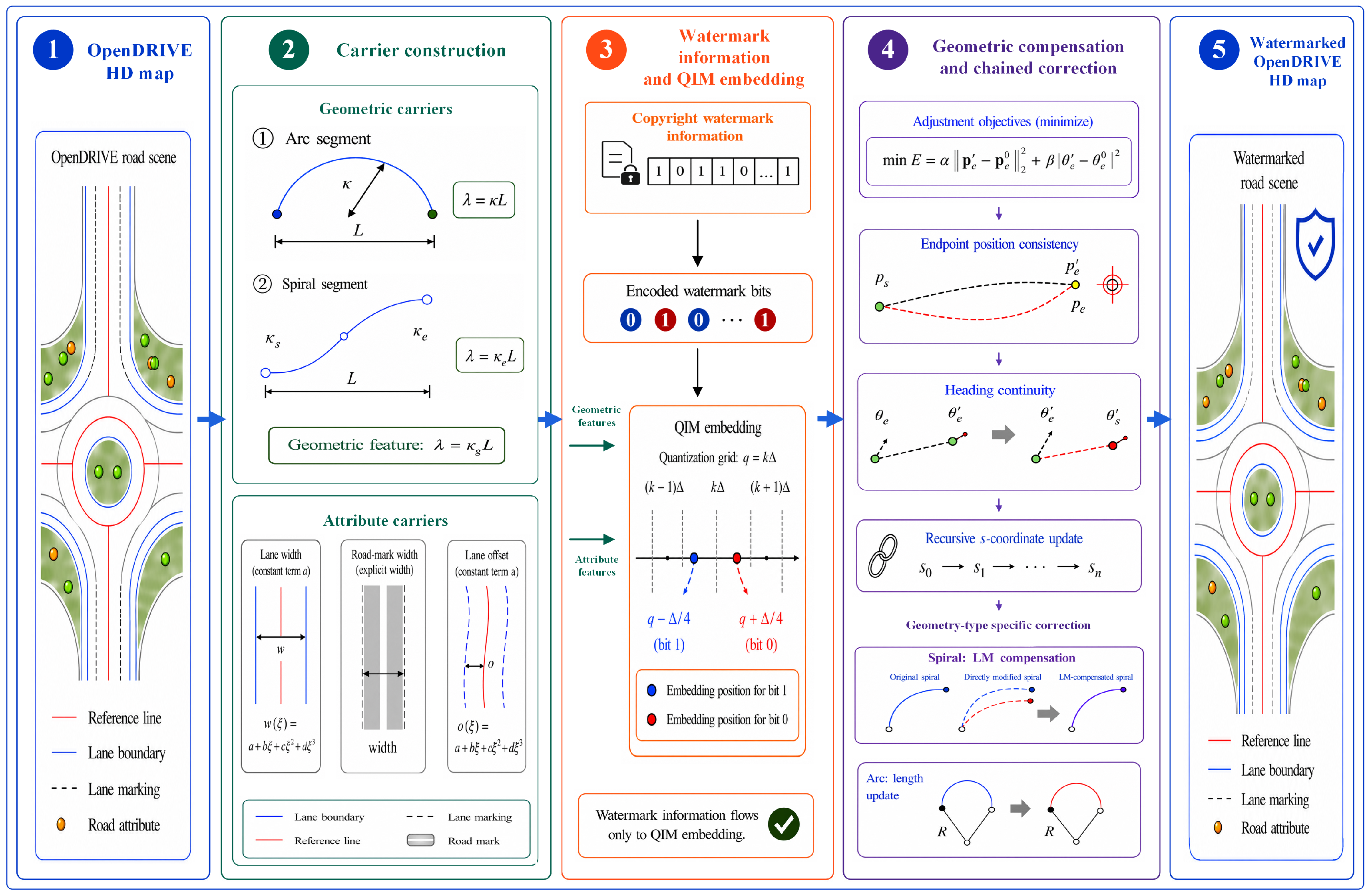
The basic concept of the proposed algorithm is illustrated in
Figure 1. During embedding, the two carrier types are first scanned according to deterministic rules, and a key-driven hash mapping disperses the carriers across the watermark bits. According to the numerical scale and constraints of each carrier type, QIM then modifies the corresponding feature values independently, thereby realizing orthogonally decoupled embedding across carrier types. Attribute carriers are written back directly after checks of their physical ranges and maximum allowable changes. Geometric carriers additionally undergo local geometric compensation and topology-aware chain correction to control changes in the current geometry element’s end position and end heading, as well as subsequent s-coordinate relationships. All selected carriers are existing numerical fields in OpenDRIVE; the algorithm does not rely on invisible characters, tag order, or nonstandard XML structures. This design reduces the risk that watermark information will be directly lost during character-level sanitization or XML restructuring.
Extraction does not require the original map. Instead, the carrier set and carrier-to-bit mapping are reconstructed using the same rules as during embedding, and QIM demodulation yields the decision bit and extraction confidence for each carrier. Because a single watermark bit can be redundantly carried by multiple carriers distributed across different roads and structural levels, the remaining carriers can still be used for weighted voting when some carriers are lost or altered by local cropping or format processing; error-correction decoding then recovers the watermark. Thus, the multidimensional carrier pool addresses carrier stability and capacity; local geometric compensation and topology-aware chain correction control the geometric effects of embedding; and hash mapping, redundant embedding, weighted voting, and error-correction decoding improve watermark recovery under complex processing conditions.
2.2. OpenDRIVE Watermark Carriers
Stable carriers are fundamental to robust watermarking of OpenDRIVE HD maps. Relying exclusively on curved geometry elements such as arcs and spirals may result in insufficient carriers in maps dominated by long straight roads, simple networks, or few curved geometries. Conversely, relying only on road attributes does not fully exploit the stability of reference-line geometry under coordinate transformations. Therefore, geometric-shape and road-attribute carriers are jointly selected because their complementary properties balance robustness to geometric transformations, carrier capacity, and geometric impact.
Geometric-shape carriers are derived from arc and spiral geometry elements of OpenDRIVE road reference lines. For an arc, curvature is constant within the geometry element, and the product of curvature and element length equals the signed heading change over that element. For a spiral, curvature varies continuously along the arc length, and the end curvature characterizes the terminal state of the curvature variation. Accordingly, the product of constant curvature and length is used for arcs, whereas the product of end curvature and length is used for spirals. These geometric-carrier features are uniformly expressed as follows:
In Equation (1), denotes the geometry-element length, and denotes the curvature parameter used to construct the carrier feature. For an arc geometry element, , where is the constant arc curvature; for a spiral geometry element, , where is the spiral end curvature. The subscript g labels this unified parameter, rather than a separate curvature measure.
This feature is independent of the absolute position and orientation of the geometry element; map translation and rotation therefore do not change its value. Under ideal positive uniform scaling, the geometry-element length changes in direct proportion to the scale factor, whereas signed curvature changes inversely, leaving their product unchanged. Accordingly, the signed curvature–length feature is invariant under orientation-preserving planar similarity transformations and provides the transformation-symmetry mechanism exploited by the geometric carriers. Under reflection, signed curvature reverses sign; reflection invariance is therefore not claimed. A line has zero curvature and therefore offers no effective curvature–length modulation space. The shape of a polynomial curve is jointly determined by several coupled coefficients, making it difficult to incorporate into a unified curvature–length modulation and compensation framework. Consequently, arcs and spirals are selected as geometric shape carriers.
Road-attribute carriers include lane width, road-marking width, and lane offset. In OpenDRIVE, lane width and lane offset are generally described by cubic polynomials of the following form:
In Equation (2), denotes the local distance along the reference line, and , , , and are polynomial coefficients. The constant term represents the baseline value at the start of the corresponding attribute record and has a clear semantic interpretation within the road model. Compared with the higher-order coefficients that control how the attribute varies along the road, slightly modulating does not introduce a higher-order perturbation that grows with local distance and does not alter the variation trend determined by , , and . Therefore, the constant term is selected for modulating lane width and lane offset.
Road-marking width is generally stored as an independent scalar attribute representing the physical width of the traffic marking. Only road-marking elements with a width attribute explicitly present in the original XML file are selected, thereby avoiding the additional structural differences that would result from inserting new attributes. These attribute values are independent of global coordinate position and remain stable under coordinate transformations such as translation and rotation. Moreover, lane widths, road-marking widths, and lane offsets are broadly distributed in OpenDRIVE files and can provide additional capacity when geometric carriers are insufficient. Nevertheless, modulating attribute carriers can still change lane widths or relative offsets; each modulated value must therefore remain within its prescribed physical range, and the magnitude of the change must not exceed the allowable limit.
The characteristics and roles of the different carriers are summarized in
Table 1. Geometric carriers primarily enhance robustness to geometric transformations, whereas attribute carriers primarily expand watermark capacity and increase redundant coverage.
All carriers selected in this study are existing numerical parameters or attribute fields in OpenDRIVE files and do not rely on invisible characters, tag order, or nonstandard XML structures. For road-marking width, only elements whose width attribute is explicitly present in the original file are selected, thereby avoiding structural differences caused by adding attributes. This design helps preserve XML validity and parseability and reduces the risk that watermark information will be lost during format sanitization or reserialization because of changes in textual representation. The specific screening criteria, quantization steps, and voting weights for each carrier type are presented in
Section 2.5.
2.3. Geometric Continuity and Road Smoothness Constraints
An OpenDRIVE road reference line consists of an ordered sequence of continuous geometry elements. Modulating attribute carriers, such as lane width, road-marking width, and lane offset, does not modify the reference-line definition. Physical-range and maximum-change constraints primarily control these attribute changes. By contrast, arcs and spirals are part of the reference-line geometry definition, and changes in curvature or length can affect the current element’s end position and end heading, as well as the s-coordinate relationships of subsequent elements. A geometric carrier cannot therefore be written back as an isolated numerical value; both local geometric and topology-aware chain constraints must be imposed.
Road smoothness depends primarily on the continuity of the reference line within each geometry element and on smooth changes in position, heading, and curvature at junctions between adjacent elements. Taking the watermark-modulated curvature–length feature as the optimization target, local geometric compensation jointly adjusts the relevant geometric parameters to control the element’s end-position error, end-heading error, and curvature variation. This reduces the risk of spatial gaps, abrupt directional changes, and curvature discontinuities at adjacent-element junctions. The basic constraint objective is expressed as follows:
In Equation (3), and denote the end positions of the geometry element before and after modification, respectively; and denote the corresponding end headings; and and are weighting coefficients. The objective is not to leave the geometric parameters unchanged but to keep the end-position and end-heading errors within acceptable ranges while satisfying the watermark modulation and decision requirements. If a curvature-continuity check is enabled, it is applied after optimization as an additional acceptance condition for the candidate solution.
For a spiral geometry element, the end state depends jointly on the start curvature, end curvature, and element length. Nonlinear optimization is therefore used for geometric compensation. For an arc geometry element, curvature remains constant over the entire element; the curvature is held fixed, and the element length is adjusted to modulate the curvature–length feature. The optimization variables, parameter-optimization procedure, error validation, and revalidation of the QIM decision are detailed in
Section 2.7.
When the length of a geometry element changes, the longitudinal positions of subsequent geometry elements, lane-related records, road objects, and traffic facilities located using the road-reference-line coordinate
must be updated consistently. If the start s-coordinate of geometry element
is held fixed, the start s-coordinates of element
and each subsequent element
are expressed as follows:
In Equation (4), is the original start s-coordinate of geometry element , is the corrected start s-coordinate of element , and is the updated length of element . Associated lane-width, lane-offset, and road-marking records, road objects, and traffic facilities located along the road reference line using the coordinate must likewise be updated consistently with cumulative length changes in the preceding geometry elements.
Local geometric compensation controls the shape error of the current geometry element, whereas topology-aware chain correction preserves consistency between subsequent geometry elements and associated objects within the reference-line parameterization. Together, they transform geometric carrier embedding from an isolated parameter replacement into a controlled modification performed under constraints on the continuous road-curve representation. These geometric constraints reduce the risk of compromising road smoothness at the model level. Overall map usability must still be validated using curvature discontinuity metrics and scenario simulation experiments.
2.4. Overall Algorithm Workflow
Building on the parametric representation of OpenDRIVE, the multidimensional carrier pool, and the geometric constraints described above, this section presents the implementation of the robust watermarking algorithm. The algorithm comprises watermark embedding and extraction. Embedding takes an original OpenDRIVE HD map file, the copyright information to be embedded, and a key as inputs and outputs a watermarked OpenDRIVE file. Extraction takes the OpenDRIVE file to be tested and the same key as inputs and recovers the copyright information without the original map.
During watermark embedding, deterministic carrier scanning, watermark frame construction, error-correction encoding, key-driven carrier-to-bit mapping, orthogonally decoupled QIM modulation, and parameter write-back are performed in sequence. Each carrier type is independently modulated using its own quantization step and constraints. Attribute carriers are written back after checks of physical ranges and maximum allowable changes. Geometric carriers additionally undergo local geometric compensation, final revalidation of the QIM decision, and topology-aware chain correction. If the effective bit coverage or overall embedding success rate does not meet the requirements, all written modifications are rolled back.
During extraction, the carrier set and carrier-to-bit mapping are reconstructed using the same rules. QIM demodulation is applied to the current feature value of each carrier, and the copyright information is recovered by combining carrier-type weights, extraction confidence, weighted voting, and Bose–Chaudhuri–Hocquenghem (BCH) decoding. Carrier scanning and bitstream construction, QIM embedding, geometric constraint processing, and blind extraction are described in
Section 2.5,
Section 2.6,
Section 2.7 and
Section 2.8, respectively.
2.5. Watermark Carrier Scanning and Bitstream Construction
To ensure that consistent carrier sets can be obtained during embedding and extraction without sharing the original map, a deterministic carrier-scanning rule is used. Let
denote the road set obtained after parsing the OpenDRIVE file. For each road, the algorithm traverses the reference-line geometry elements, lane sections, lane-width records, road-marking records, and lane-offset records in sequence and encapsulates each numerical object satisfying the screening criteria as a watermark carrier. Each carrier is represented as follows:
In Equation (5), is the unique carrier identifier, is the carrier type, is the feature value to be modulated, is the quantization step, is the voting weight used during extraction, and is the set of physical or geometric constraints that the carrier must satisfy.
The unique carrier identifier is constructed from structural information that is unchanged by watermark modulation. For a geometric carrier, the road identifier and the fixed index of the geometry element within the current road’s reference-line geometry sequence are used; the start s-coordinate , which may change during topology-aware chain correction, is excluded. For an attribute carrier, the lane-section index, lane identifier, and index of the corresponding attribute record are combined. Consequently, consistent carrier identifiers can be reconstructed at both ends even after geometry-element lengths and subsequent start s-coordinates change. After scanning, all carriers are deterministically sorted by to avoid synchronization errors caused by different traversal orders.
The physical interpretation and selection rationale for each carrier type were described in
Section 2.2. This section specifies only the scanned objects and fields used for modulation. The attribute dimension comprises the constant term
width.a of the lane-width polynomial, the
roadMark.width attribute explicitly present in the original XML, and the constant term
laneOffset.a of the lane-offset polynomial. The geometric dimension comprises arc and spiral geometry elements, whose modulation targets are
and
, respectively. Objects satisfying the screening criteria in
Table 2 are represented using a unified carrier structure.
For geometric carriers, a signed curvature–length composite feature is used as the QIM modulation target. The feature values for arc and spiral elements are defined, respectively, as follows:
In Equations (6) and (7), is the length of geometry element , is the constant curvature of an arc, and is the end curvature of a spiral. Because the curvature sign represents the turning direction, the sign of is retained during QIM modulation. During carrier screening, is used to determine whether the magnitude of the geometry element’s curvature–length feature is sufficiently large. This preserves the turning information of the arc or spiral while avoiding unstable carriers caused by excessively small curvature or very short geometry elements.
The modulation parameters and screening criteria for the different carriers are listed in
Table 2.
The quantization steps were set to balance the QIM decision margin against the perturbation of the map parameters. For the two target positions in Equation (14), the opposite-bit locations are separated by half a quantization period, and the nominal nearest-decision margin is one quarter of the step. Increasing the step therefore improves tolerance to perturbation but also increases the possible change in the carrier feature; a smaller step has the opposite effect. With the selected steps, the maximum QIM displacement is bounded by three quarters of the step, corresponding to 7.5 × 10⁻⁶ for the dimensionless geometric feature, 7.5 mm for lane width, 3.75 mm for road-marking width, and 1.5 mm for lane offset. The threshold |λ| ≥ 1.2 × 10⁻⁴ excludes geometric features close to zero, for which the same absolute modulation would produce a comparatively large relative change, while the minimum-length requirements exclude short elements for which a local parameter change may have a disproportionate geometric effect.
The attribute-screening bounds provide an initial margin around the prescribed physical ranges; after modulation, the physical-range and maximum-change checks described in
Section 2.6 reject any candidate that violates these constraints. The voting weights encode the relative reliability and complementary roles of the carrier types: geometric carriers receive the highest weight because of the signed curvature–length feature’s invariance under orientation-preserving similarity transformations, lane-width carriers provide broad coverage, and road-marking-width and lane-offset carriers provide supplementary redundancy. These fixed engineering parameters were used unchanged for all three datasets and are not claimed to be globally optimal.
After carrier scanning, a watermark frame is constructed for the copyright information to be embedded. Let
denote the copyright information and
its binary representation. To enable self-synchronization during extraction without prior knowledge of the original message length, a self-describing watermark frame comprising a flag field, a length field, and a payload field is constructed as follows:
In Equation (8), is the flag field, is the message-length field, denotes the error-correction encoding function, and denotes bit-string concatenation. A 12-bit flag field and an 8-bit length field are used. The flag field records whether BCH coding is enabled, whereas the length field records the message length and is used for candidate-frame self-validation during extraction. When the number of carriers satisfies the BCH capacity requirement and reaches the preset activation threshold, the length field and message payload are jointly encoded using BCH(15, 7, 2). If the number of carriers is insufficient to support BCH redundancy, the unencoded length-and-payload bit string is used directly.
Let
be the number of carriers and
the final watermark-frame length. To ensure sufficient redundant coverage of the watermark bits, the average carrier redundancy is defined as follows:
The average carrier redundancy defined in Equation (9) is used only to determine whether the current map satisfies the preliminary capacity and average-redundancy requirements; it does not guarantee coverage of every watermark bit. In this study, . Embedding is terminated when . After the overall capacity check, the actual coverage of every watermark bit is further counted after hash mapping and carrier-constraint screening.
The minimum average redundancy controls whether embedding can proceed; it does not set the number of redundant copies. Similarly, the normalized correlation (NC) threshold is an evaluation criterion and does not enter blind extraction.
2.6. Watermark Embedding Based on Hash Mapping and QIM
After obtaining the multidimensional carrier pool and watermark bitstream, the keyed Fowler–Noll–Vo 1a (FNV-1a) hash function is used for dispersed carrier-to-bit mapping, thereby reducing the risk that sequential embedding will cause contiguous bit losses under local cropping.
In Equation (10), is the FNV-1a hash function, and is the index of the watermark bit to which carrier is mapped. Because , , and jointly enter the hash calculation, carriers of different types can still yield different bit assignments even when they have similar road identifiers or local indices. During extraction, the same mapping can be reconstructed using the same key and carrier-identification rule, without additional synchronization information.
After all carriers have been mapped, the number of carriers assigned to watermark bit
is defined as follows:
According to Equation (11), the actual coverage count of every bit position is determined. If
the condition in Equation (12) holds, at least one watermark bit is not carried by any carrier. The current mapping thus fails the complete-embedding requirement, and the current embedding attempt is terminated. Equation (9) controls the average redundancy, whereas Equation (12) ensures that the initial mapping leaves no watermark-frame bit uncovered.
For a carrier mapped to watermark bit
, QIM is used to slightly modify its feature value. Let
be the original carrier feature and
the quantization step. The feature is first quantized to the nearest lattice point:
Equation (13) quantizes the carrier feature to the nearest lattice point. The target bit then selects one of two offset positions relative to this point:
In Equation (14), is the modulated target feature. Bits 0 and 1 are placed on opposite sides of the quantization lattice point. During extraction, represents the position within the current quantization period; the watermark can therefore be recovered through a nearest-neighbor decision based on wrapped residual distances.
For a road-attribute carrier, embedding mainly consists of directly writing back the target attribute value. For a lane-width carrier, only the constant polynomial term
is modified, while the higher-order terms
,
, and
remain unchanged. For a lane-offset carrier, only the constant term
of the
polynomial is modified. For a road-marking-width carrier, only the existing
attribute in the original file is modified. To avoid unreasonable changes in road semantics, range constraints are checked before modifying attribute carriers:
In Equation (15), is the maximum allowable change for this carrier type, and is its prescribed physical range. If the modulated value fails to satisfy either constraint, the carrier is excluded from final embedding. Because attribute carriers do not directly alter the geometry of the road reference line, attribute values that pass both constraint checks can be written directly back to the OpenDRIVE file while preserving the numerical precision and representation used in the original file.
For a geometric carrier, the target feature is the modulated curvature–length composite feature . Changing geometric parameters affects not only the current geometry element but potentially also its end position, end heading, and the s-coordinate relationships of subsequent elements. Therefore, a geometric carrier cannot be written back directly after QIM modulation; it must undergo local geometric compensation, final revalidation of the QIM decision, and topology-aware chain correction.
2.7. Geometry-Constrained Compensation and Topology-Aware Chain Correction
After QIM modulation, an arc or spiral carrier must satisfy the geometric constraints described in
Section 2.3. This requires parameter determination, geometric error validation, final revalidation of the QIM decision, and topology-aware chain correction. This section presents the parameter calculations and acceptance procedures for the two geometric-carrier types.
For a spiral geometry element, curvature varies continuously along the arc length, and the local curve shape is jointly determined by the start curvature
, end curvature
, and length
. Let the spiral’s end position and end heading before embedding be
and
, respectively. The pre-embedding curvature–length feature is given by Equation (16).
According to the QIM modulation rule, the target feature is expressed as follows:
In Equation (17),
corresponds to embedding bit 0, and
corresponds to embedding bit 1. The candidate end curvature is first calculated using the original length, as shown in Equation (18).
Geometric-compensation optimization is then performed with the candidate end curvature
as the watermark-modulation target. With the start position and start heading of the geometry element held fixed, the element length and start curvature are jointly adjusted. The optimization variables are represented as follows:
In Equation (19), and are the optimized geometry-element length and start curvature, respectively. Taking the original start position and start heading as fixed boundary conditions, spiral integration is used to calculate the end position and end heading under the optimized parameters.
Local compensation minimizes the end-position and end-heading errors:
In Equation (20), and are weighting coefficients. The spiral end position and heading are calculated by curve integration and depend nonlinearly on the optimization variables. The Levenberg–Marquardt method is therefore used to solve Equation (20) iteratively. If a curvature-continuity check is enabled, the optimized end curvature of the current element is compared with the start curvature of the subsequent element, and candidates that fail the preset threshold are rejected.
After optimization, the end-position and end-heading errors of the spiral are defined as follows:
In Equation (21), and are the end position and end heading, respectively, of the optimized spiral.
Because geometric compensation changes the spiral length, validating only the position and heading errors cannot guarantee that the embedded bit remains valid. The actual curvature–length feature after compensation must therefore be recalculated using Equation (22).
The final decision bit
is then obtained using the QIM nearest-neighbor rule described in
Section 2.8.
The embedding result for the spiral carrier is accepted only when the condition in Equation (23) holds; otherwise, the carrier is discarded. Equation (23) prevents compensation-induced length changes from moving the final feature across a QIM decision boundary.
For an arc geometry element, curvature remains constant throughout the element, and the parameter relationship is simpler. Let the arc curvature be
and its length be
; the corresponding feature is given by Equation (24).
The target feature for the arc carrier is obtained using the same QIM rule in Equation (17).
With the arc curvature
held fixed, Equation (25) gives the target length.
Because is obtained by slightly modulating the original , generally remains positive when the minimum-feature threshold and relative length-change constraint are satisfied. If the calculated violates the relative length-change constraint or produces a geometric error above the threshold, the arc carrier is excluded from final embedding. Otherwise, the new length is written back and chain correction is performed.
To apply a consistent acceptance procedure to the two geometric-carrier types, the QIM decision is also revalidated before an arc carrier is written back.
When a geometry-element length changes, the start s-coordinates of subsequent geometry elements on the same road are recursively updated according to Equation (4) in
Section 2.3. The cumulative length change of preceding geometry elements is also propagated consistently to the longitudinal positions of associated lane records, road markings, road objects, and traffic facilities referenced to the road-reference-line coordinate
. This operation preserves element ordering and the consistency of the associated objects within the road-reference-line parameterization.
After all carriers have been processed, the effective bit coverage provided by the successfully written carriers is counted. Define the carrier write-status variable
. For carrier
,
if it passes the constraint checks and is successfully written to the file; otherwise,
. The effective coverage count of the watermark bit
is defined by Equation (26).
If for any watermark bit, that bit has no effective carrier coverage after constraint screening, and all written modifications are rolled back. The changes are committed and a watermarked file is output only when every watermark bit is effectively covered by at least one carrier and the overall embedding success rate meets or exceeds the preset threshold.
Local geometric compensation controls the end state of the current geometry element, whereas topology-aware chain correction preserves parameter consistency for subsequent elements and associated objects. The complete watermark-embedding procedure is summarized in Algorithm 1.
| Algorithm 1. Watermark embedding procedure |
Input: original OpenDRIVE file , copyright information , and key .
Output: watermarked OpenDRIVE file .Parse the original OpenDRIVE file . Construct the carrier set according to the deterministic carrier-scanning rules (Equations (5)–(7) and Table 2). Construct the watermark frame (Equation (8)) for the copyright information . If the BCH capacity and activation conditions are satisfied, apply BCH encoding to the length-and-payload field; otherwise, retain this field uncoded. The resulting frame constitutes the watermark bitstream . Calculate the average carrier redundancy using Equation (9); terminate embedding if the threshold requirement is not met. Calculate the hash-mapped index for each carrier . Use Equation (10). Count the initial coverage of every watermark bit using Equation (11); terminate embedding if Equation (12) holds. Apply QIM to the carrier feature according to . Use Equations (13) and (14). If is an attribute carrier, check the modulated value against its physical range and maximum allowable change before writing it back (Equation (15)). If is a geometric carrier, determine the compensated parameters and validate the geometric errors (Equations (16)–(25)). Revalidate the final QIM decision (Equations (29)–(33)) and apply chain correction (Equation (4)). Count the effective bit coverage of successfully written carriers using Equation (26). If any bit is uncovered or the overall embedding success rate is below the preset threshold, roll back all written modifications. Output the watermarked OpenDRIVE file .
|
2.8. Blind Extraction Based on Weighted Voting
Watermark extraction does not require the original OpenDRIVE file. Instead, the carrier set in the file under test is reconstructed using the same carrier-scanning rules as during embedding. Let
be the map under test; the scanned carrier set is given by Equation (27).
For each carrier, the unique identifier is reconstructed using the stable-identification rule in
Section 2.5. The carrier type and the same key are then used to calculate the watermark-bit index. The carrier-to-bit mapping during extraction is shown in Equation (28).
Local cropping may remove some carriers, and reserialization may alter the textual form of the XML. Nevertheless, if the structural indices of the remaining carriers are preserved, their watermark-bit indices can still be reconstructed independently from the stable identifiers and key.
For the current feature value
of each carrier, the extractor first calculates a nonnegative residual within the quantization period. Define
In Equation (29), denotes the nonnegative modulo operation. When is negative, the residual is still mapped to the interval , avoiding periodic ambiguity when demodulating attribute carriers such as lane offsets that may take negative values. This formulation, based on a nonnegative modulo residual, is equivalent to normalization relative to the nearest quantization lattice point; both map the QIM residual into one quantization period for wrapped-distance decisions.
Under the embedding rule, the ideal residual positions for bits 0 and 1 are
and
, respectively. Accounting for the periodic wraparound of the quantizer, the periodic distance function is defined as follows:
Using Equation (30), the distances from the current carrier to the two ideal embedding positions are
Equations (31) and (32) give the distances from the current carrier to the ideal residual positions of bits 0 and 1, respectively. The hard decision for the carrier is obtained using the nearest-neighbor rule:
In Equation (33),
denotes the indicator function. When
,
; otherwise,
. When
, the hard decision is set to 0. To quantify the reliability of an individual carrier’s demodulation result, the QIM extraction confidence is further defined as follows:
In Equation (34), . When a carrier residual is close to an ideal embedding position, approaches 1, indicating a reliable demodulation result. When the residual approaches the decision boundary, approaches 0, indicating that the carrier contributes little to the decision for the current bit.
Because each watermark bit may be redundantly carried by multiple carriers, weighted voting is used for bit recovery. The index set of carriers mapped to watermark bit
is defined by Equation (35).
For this bit position, the weighted votes for 0 and 1 are calculated, respectively, as follows:
In Equations (36) and (37),
is the carrier-type weight. The weights in
Table 2 are used: 1.2, 1.0, 0.8, and 0.6 for geometric, lane-width, road-marking-width, and lane-offset carriers, respectively. The final decision for the watermark bit
is given by Equation (38).
Combining carrier-type weights with QIM confidence reduces the influence of low-confidence carriers on the final decision. Under local cropping, some carriers may be lost, but the surviving carriers can still vote for their corresponding bits. When a small number of carriers are affected by numerical rewriting or format conversion, BCH coding and weighted voting can jointly improve the probability of watermark recovery.
Because the message length is not known initially during extraction, candidate message lengths from 1 to 30 characters are examined. For each candidate length, both the uncoded and BCH-coded frame lengths are evaluated, and carrier mapping, QIM demodulation, and weighted voting are performed for each resulting candidate frame length. In the uncoded mode, the length field is read directly. In the BCH-coded mode, the encoded payload is first BCH-decoded, after which the length field is read from the decoded payload. A candidate is considered self-consistent only if the recovered length equals the assumed candidate length and the flag field agrees with the assumed coding mode. If multiple candidates are self-consistent, the candidate with the highest mean voting confidence is selected as the final output.
After candidate message length detection, QIM demodulation, weighted voting, and error-correction decoding, the blind watermark extraction procedure is summarized in Algorithm 2.
| Algorithm 2. Blind watermark extraction procedure |
Input: OpenDRIVE file under test and key .
Output: extracted copyright information .Parse the OpenDRIVE file under test . Construct the carrier set using the same rules as during embedding (Equation (27) and Table 2). For each candidate message length from 1 to 30 characters, determine both the uncoded and BCH-coded candidate frame lengths using the frame structure in Equation (8) and the coding rules in Section 2.5. Calculate the hash-mapped index for each carrier . Use Equation (28). Demodulate each carrier using QIM according to its type to obtain the hard-decision bit and confidence . Use Equations (29)–(34). Perform weighted voting among the carriers mapped to the same bit position using Equations (35)–(37). Obtain the candidate watermark bitstream . Use Equation (38). Decode the flag field in Equation (8) and verify that it agrees with the assumed coding mode. For a BCH-coded candidate, apply BCH decoding to the encoded payload before reading the length field; for an uncoded candidate, read the length field directly. Retain the candidate only if the recovered length matches the assumed message length. The frame and BCH coding are specified in Equation (8) and Section 2.5. Output the recovered copyright information .
|
4. Discussion
4.1. Mechanisms and Performance Trade-Offs
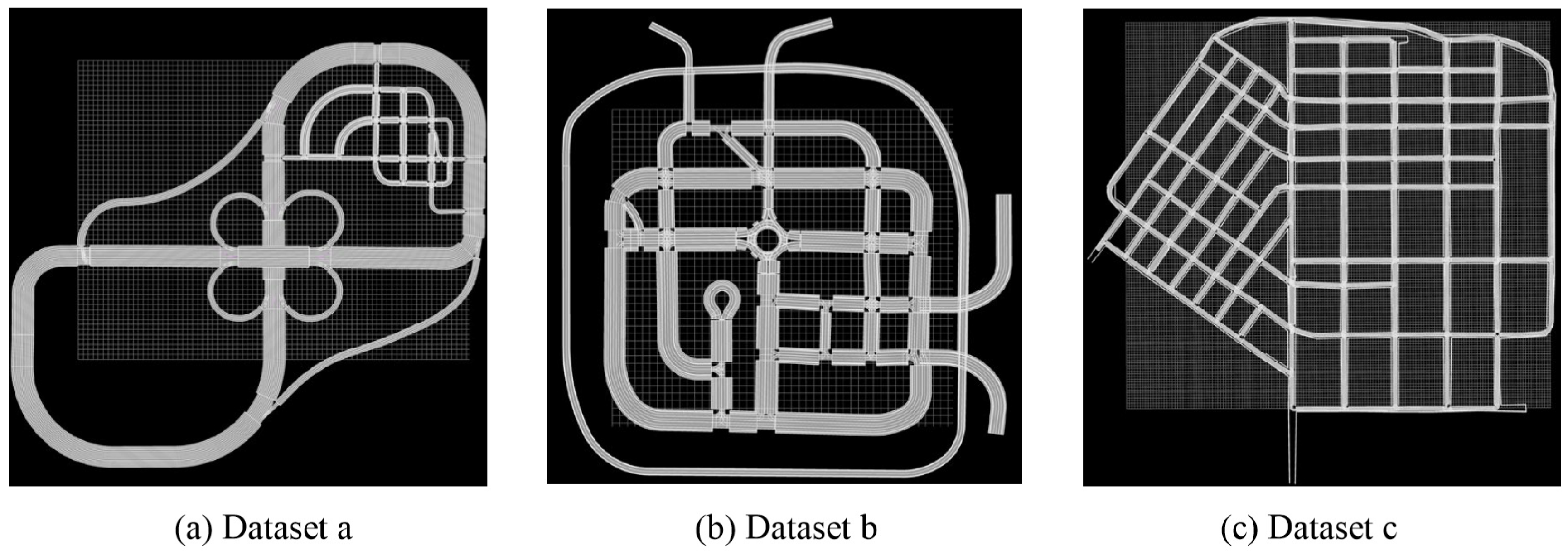
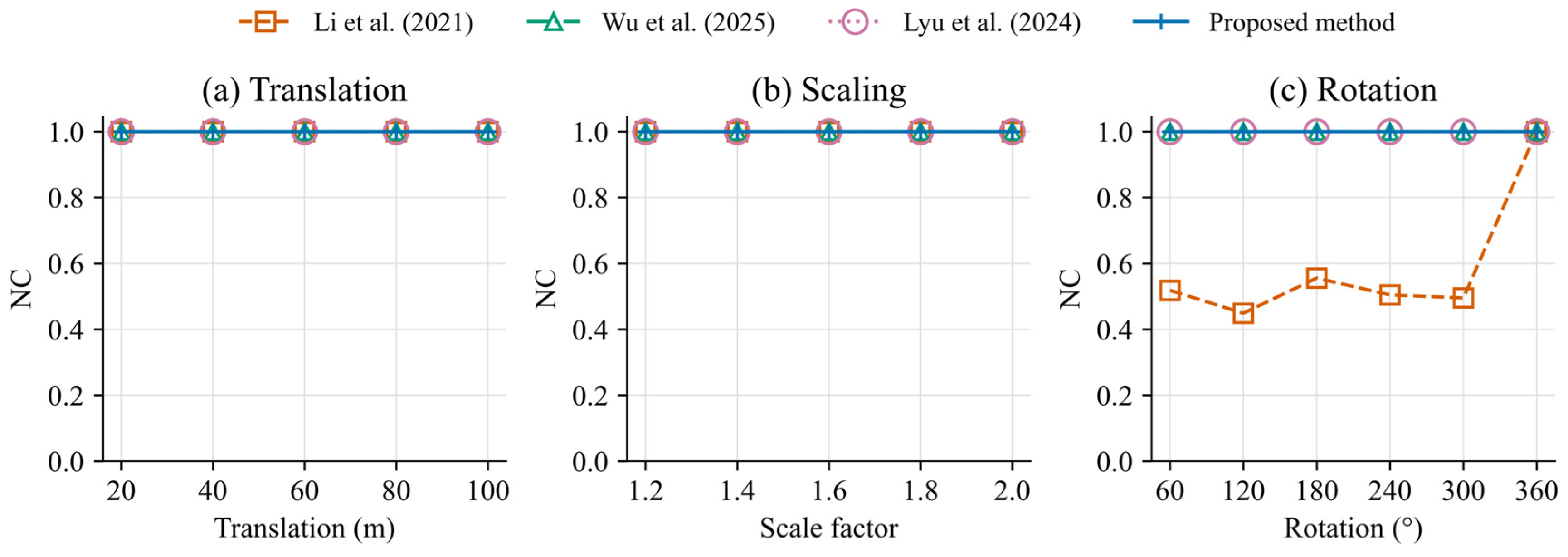
By jointly using geometric-shape and road-attribute carriers, the proposed method mitigates the limitations in stability and capacity associated with reliance on a single carrier type. The geometric-carrier feature is independent of the global position and orientation of a geometry element and is scale-stable under ideal uniform scaling; it therefore primarily enhances robustness to geometric transformations. Attribute fields such as lane width, road-marking width, and lane offset are widely distributed in OpenDRIVE files and can supplement carrier capacity when few arcs and spirals are available. Dataset c, which lacked eligible geometric carriers, still supported watermark embedding and extraction through lane-width carriers, indicating that the multidimensional carrier pool improves adaptability to different carrier compositions. Nevertheless, the number of carriers of each type is jointly determined by map structure, attribute-field completeness, and screening thresholds. Therefore, neither a sufficient number of usable carriers nor satisfaction of the specified redundancy requirement can be guaranteed for every OpenDRIVE file.
Watermark recoverability under different processing conditions results from the combined action of several mechanisms. Robustness to geometric transformations mainly derives from the stability of under translation, rotation, and ideal uniform scaling. Adaptability to format processing arises because the watermark is embedded in existing OpenDRIVE numerical fields rather than whitespace, invisible codes, or XML formatting. Under local cropping, carriers distributed across roads and structural levels carry watermark bits through key-driven hash mapping, reducing the risk that deletion of local objects will remove contiguous blocks of watermark bits. Weighted voting uses surviving carriers to make bit decisions, and BCH decoding further corrects some erroneous bits. Nevertheless, watermark-extraction performance declines as the cropping ratio increases, indicating that cropping robustness is jointly constrained by the distribution of surviving carriers, effective per-bit coverage, and error-correction capacity. The method mitigates local carrier loss but cannot completely eliminate information loss caused by extensive cropping.
The results under translation, rotation, and the tested uniform-scaling operation are consistent with the similarity invariance of the signed curvature–length geometric feature. This mechanism should not be generalized to reflections, nonuniform scaling, curve refitting, or road re-segmentation; moreover, attribute carriers are not intrinsically scale-invariant if their physical values are rescaled.
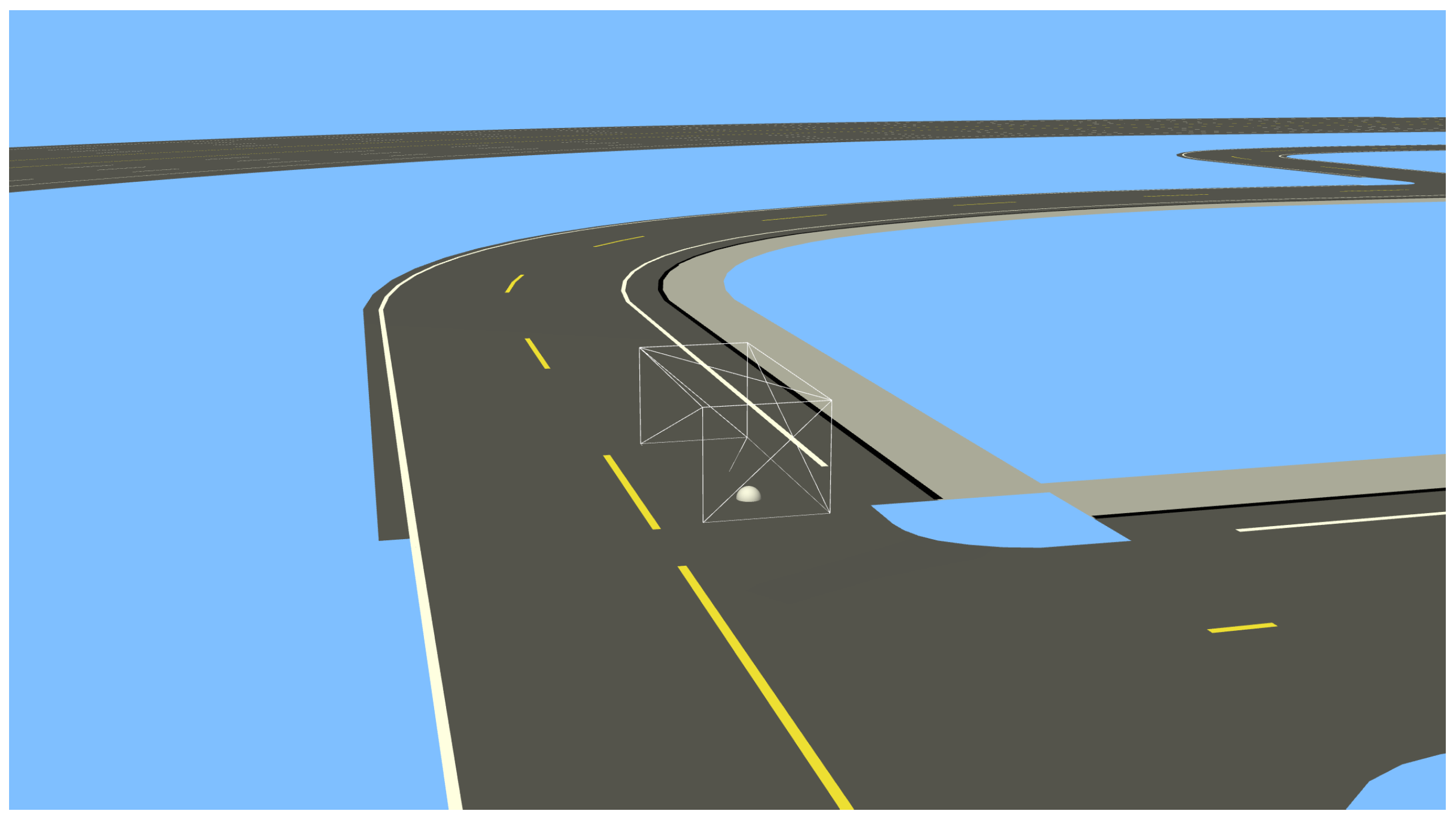
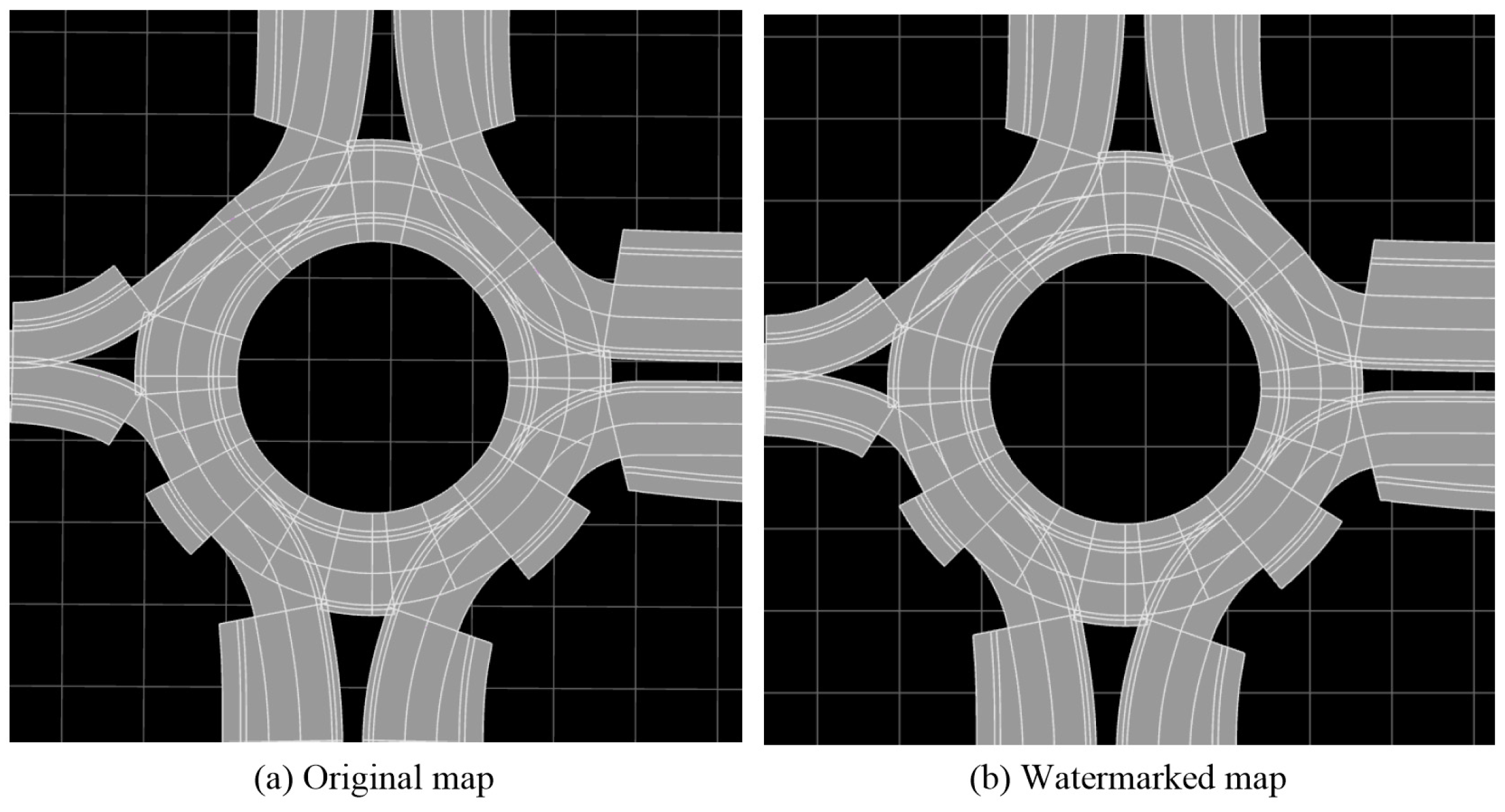
A necessary trade-off also exists between watermark robustness and map usability. Directly modulating existing numerical fields avoids adding XML tags or invisible characters and therefore limits file-size growth. However, changes in the curvature and length of geometric carriers can affect the end state of the current geometry element and the s-coordinate relationships of downstream elements. Local geometric compensation constrains changes in the current element’s end position and end heading, whereas topology-aware chain correction preserves the consistency of subsequent elements and associated objects within the reference-line parameterization. The endpoint errors of reference-line geometry elements, maximum curvature discontinuities, and esmini simulation results are consistent with these design objectives. Under the parameter settings and test scenarios used here, the fully constrained embedding process kept the influence of watermark modulation on road geometry and simulation use within the experimental thresholds.
4.2. Applicability and Limitations
The experimental conclusions have explicit conditions of applicability. The geometric-transformation experiments mainly considered translation, rotation, and uniform scaling without refitting road parameters. The format-sanitization and conversion experiments required preservation of the numerical semantics of the carrier fields and the structural identifiers used to reconstruct the carrier-to-bit mapping. Processing that truncates numerical precision, re-segments roads, refits curves, deletes attribute fields, or changes structural indices may alter both carrier features and identifiers, thereby affecting synchronization of the hash mapping and QIM decisions. The present results therefore demonstrate adaptability to conventional processing that preserves the parameter semantics and principal structure of OpenDRIVE; they do not imply resistance to arbitrary data reconstruction.
This study has several limitations. First, only three OpenDRIVE datasets were used, and their carrier compositions differed substantially. They are insufficient to comprehensively characterize carrier distributions across road structures, data sources, and modeling tools. Second, geometric errors were evaluated primarily at the endpoints of reference-line geometry elements; the effects of lane-width and lane-offset modulation on complete lane boundaries were not continuously evaluated along the road. Third, the quantization steps, voting weights, and carrier-screening thresholds were set mainly according to road semantics, numerical scale, and experimental experience, and their optimal combination and behavior near the capacity boundary require further investigation. The experiments also focused mainly on the complete algorithm and did not separately quantify the contributions of local geometric compensation, topology-aware chain correction, weighted voting, and BCH error correction. Future work should include OpenDRIVE datasets from more sources and over a wider range of scales, calculate continuous lane-boundary errors at fixed intervals along the reference line, and conduct ablation and parameter-sensitivity analyses of the key modules. Watermark stability under stronger reconstruction operations, including road re-segmentation, curve refitting, and reduced numerical precision, should also be investigated.