Article

The Economic Centrality of Urban Centers in the Medieval Peloponnese: Late 11th–Mid-14th Centuries

Department of Byzantine Studies, University of Cologne, 50923 Köln, Germany
Land 2018, 7(4), 153; https://doi.org/10.3390/land7040153
Submission received: 29 October 2018 / Revised: 27 November 2018 / Accepted: 28 November 2018 / Published: 7 December 2018

Abstract

:
The Peloponnese, a province of the Byzantine Empire in the 11th and 12th centuries, was divided into three distinct political entities after 1204: the Frankish Principality of Achaia, the Venetian colonies of Modon and Coron, and the Byzantine lands in the southeast. The number and size of cities in the Peloponnese during the 11th and 12th centuries expanded, and the establishment of the new political entities of the 13th century did not hinder the development of its urban centers. New urban centers appeared, and the dynamics of the old urban centers witnessed a major shift. The focus of this paper is on port towns, since the majority of the available data derive from them, and aims to investigate the economic centrality of the port towns in the Peloponnese in the context of their environs, economic activities, and their position in the eastern Mediterranean exchange system. The theoretical framework is based on concepts of network theory, centrality, and economic complexity, as well as on a thorough evaluation of the material and textual evidence. In doing so, the economic profile of each central place is reconstructed, as well as a comparison between them.

1. Introduction

The late 11th and mid-14th centuries in the medieval Eastern Mediterranean are marked by the cultural and economic transformation of the societies living on its shores. In particular, the 11th and 12th century witnessed the economic growth of the Byzantine Empire, the dissolution of the Byzantine Empire in 1204 by the fourth Crusade, and the establishment of the various Crusader States on its shores [1,2,3]. Moreover, the restoration of the Byzantine Empire in 1261, by Michael VIII Palaelogos, did not signify the recovery of all the Byzantine lands from before 1204 [4] (p. 804).
Interestingly, in the 11th and 12th centuries, the Byzantine Empire was the main export outpost for luxury items, such as ceramics, textiles, and glass, to Europe [5] (p. 740) but, by the late 13th century, the same region (now including the restored Byzantine Empire and Latin States) had become a large importer of manufactured products from the West [6] (pp. 185–216). The Peloponnese in Greece forms the focus of this study, due to its central position within these developments and its position in the center of the maritime routes between East and West (Figure 1).
This paper studies the impact of these wider developments in the Eastern Mediterranean by using the urban centers of the Peloponnese as case studies. The aim of this paper is to analyze the economic profile of each town and examine, empirically, their hierarchy, and the degree of their centrality between the late 11th and mid-14th century. This is the first time that the economic evolution of the medieval urban centers in the Peloponnese is approached, based on aspects of central place theory, network analysis, and economic complexity. Concepts of network theory will provide the tools to visualize relationships between settlements, and concepts of centrality will emphasize the economic and sociopolitical dynamics of each town, and reconstruct their hierarchy in the economic topography of the Peloponnese, while the concept of economic complexity will illustrate the variety of the economic activities that took place in the Medieval Peloponnese and the way these activities interconnect with the concepts of centrality.

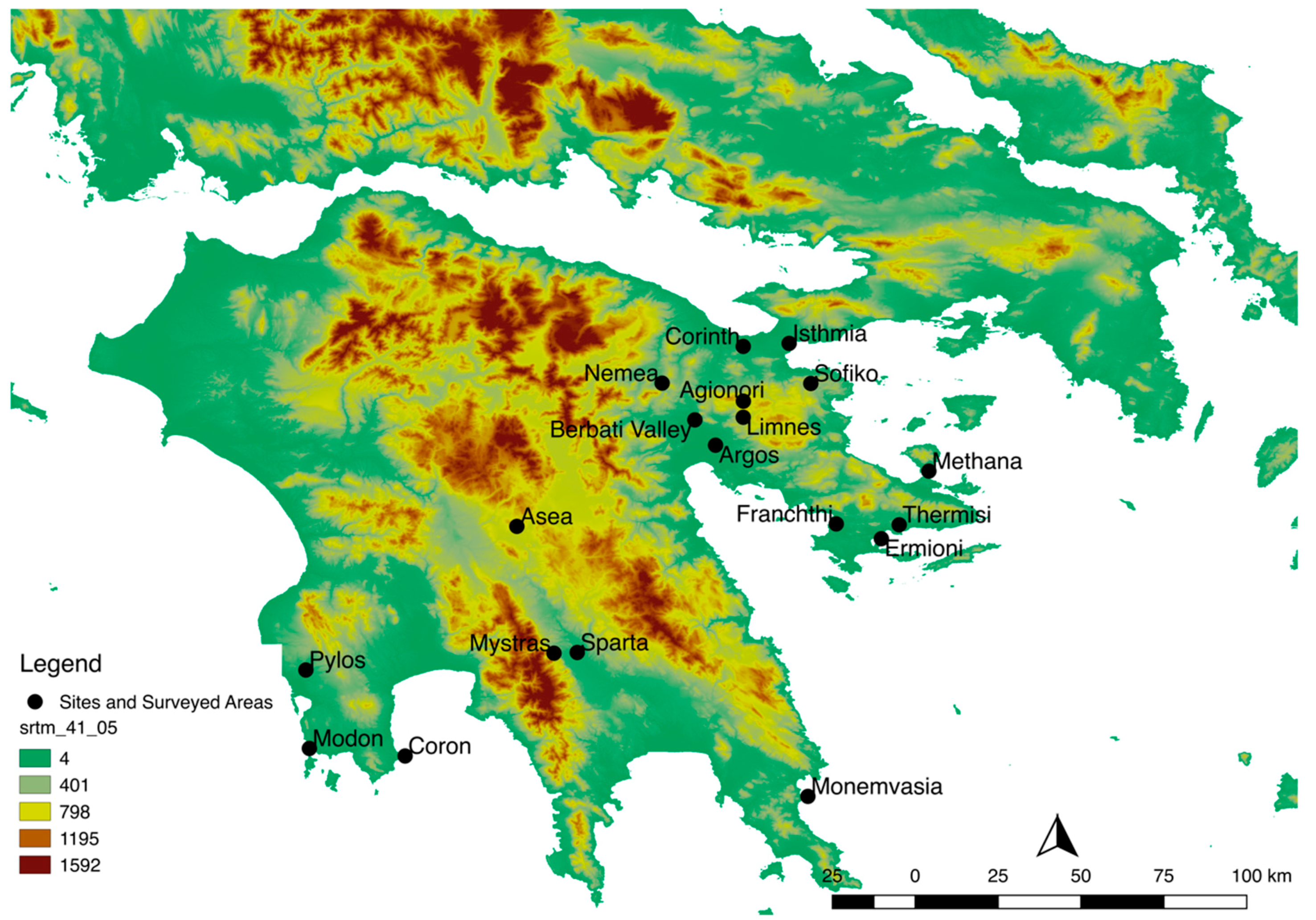
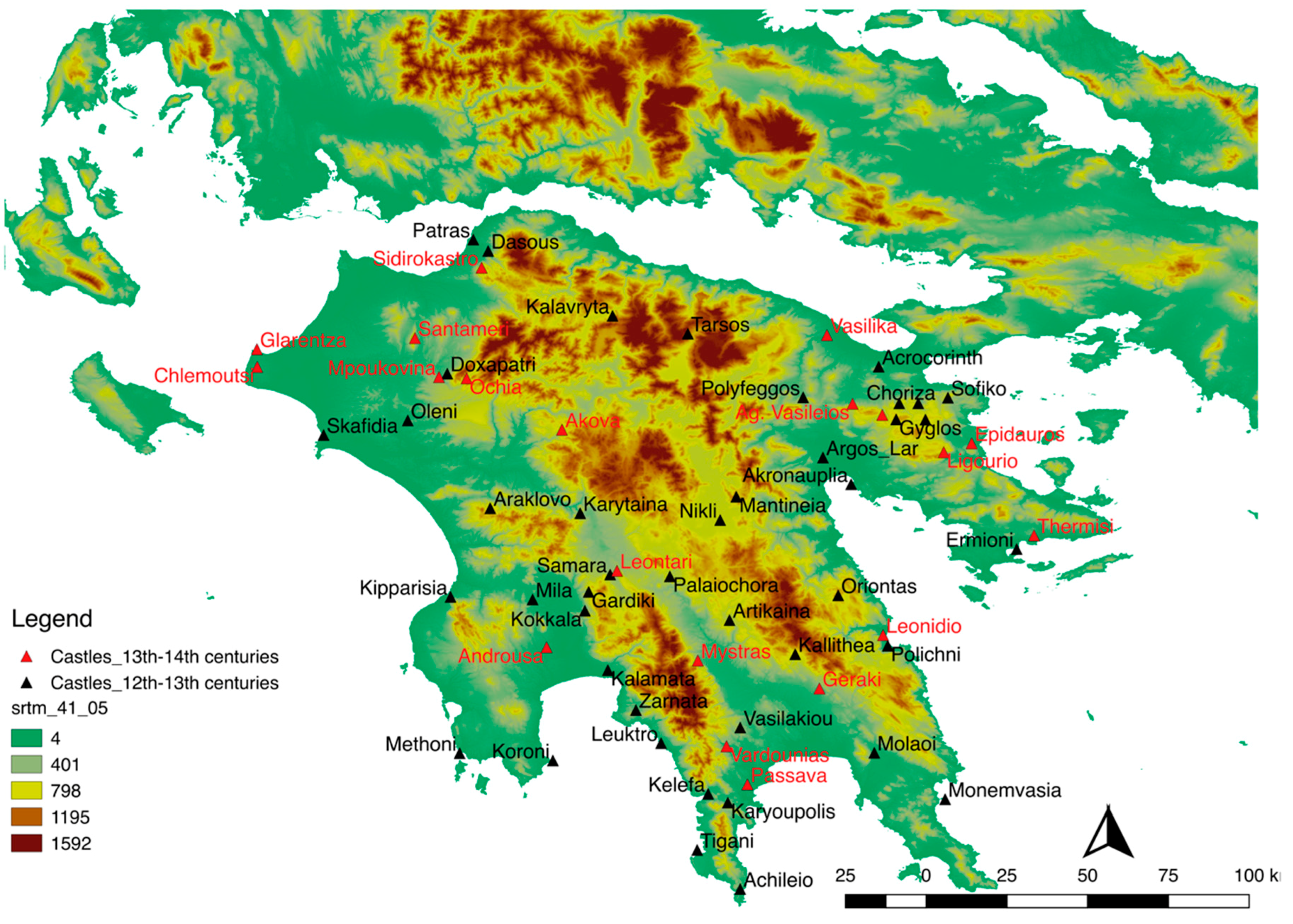
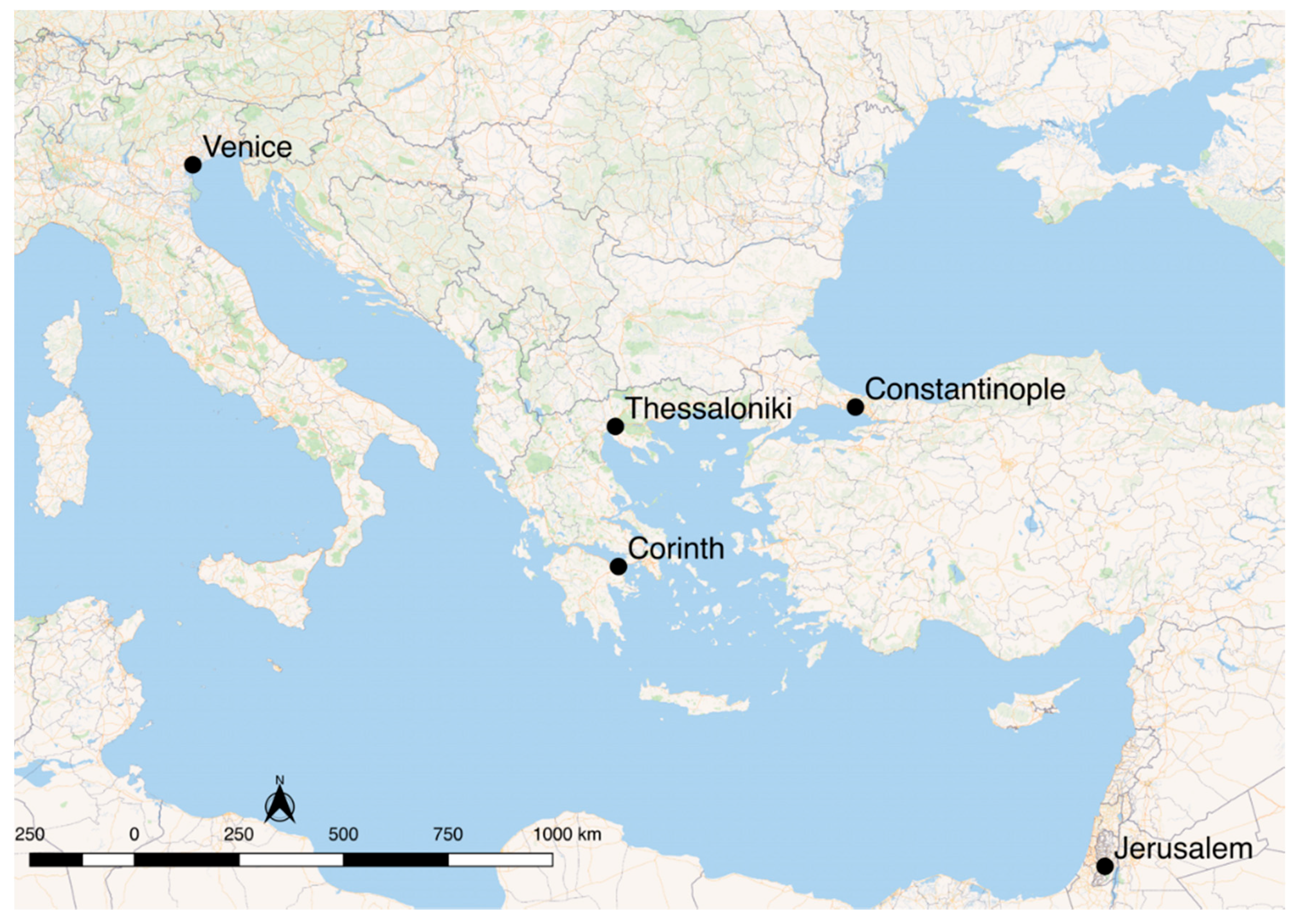
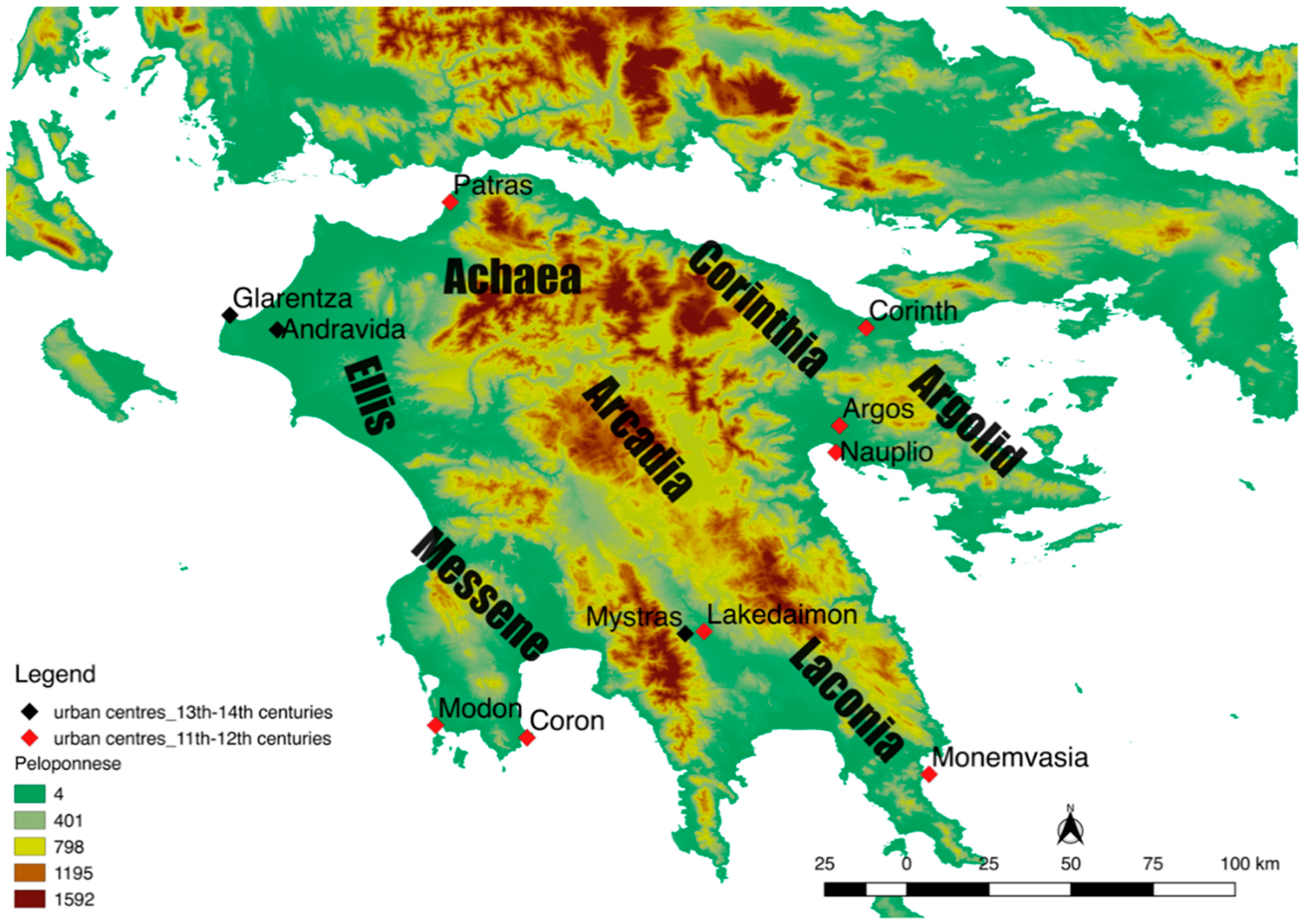
2. The Environment of the Medieval Peloponnese

The Peloponnese is a typical Mediterranean landscape, with mountains often dropping into the sea resulting in a deep coastline; among these mountains, there are either small or large valleys [7] (p. 32). The Peloponnese is located in the southern part of modern Greece; to its west is the Ionian Sea, and to its east the Aegean. According to Campbell [8] (pp. 332–355), the climate conditions have not seen drastic deviations from the Medieval period to the modern times, though there were some periods with low temperatures and extreme weather events. Thus, in the Peloponnese, the climate must have been characteristically Mediterranean with a warm and dry summer from June to August, and a moist period during the autumn, winter, and spring, along with some cold and drought events within the year.
In the region there were agrarian, woodlands, and semi-natural areas, which encompassed high alpine plants and forests with pines and firs in the mountains [9] (p. 42). The agronomic zones were located along the river valleys and lowland plains, yet vineries and olive groves can also be found in dry regions [10] (pp. 18–20). Therefore, the agro-productive areas in the Peloponnese covered the plains of Argolid in the northeast, in Ellis in the northwest, and in Messene in the southern part. There are also agricultural areas in the river valleys of Laconia and Achaea, as well as arable and pastoral sectors in the eastern coastlands of Corinthia. In the mountainous districts, such as Arcadia, large terrains for the farming of cereals are unusual, but this type of environment is suitable for the cultivation of trees [7] (p. 32); hence, these districts must have been mainly used for stock-raising. Due to the climate and fertile zones of the Peloponnese, olives can be cultivated, as well as non-irrigated cereals, and grapes for wine production (Figure 2).
Near the natural harbors, significant urban centers were developed in the Middle and Late Medieval periods, which functioned as ports of outlet for the commodities and goods of the Peloponnese, and also as depositories for products shipped from the wider eastern Mediterranean. The city of Corinth had two ports, Lechaion and Kenchreai, which contributed greatly to its commercial activities during the period in question [11] (pp. 71–73). The port of Nauplion in Argolid, from the late 11th century onwards, became an important transshipment spot [12] (pp. 214–215). In the medieval period, the port of Patras in Achaea was the first stop in the Peloponnese for ships travelling to and from the Ionian islands, Italy, and southeastern France [13] (p. 306). In Laconia, from the mid-10th century, the continuous advance of the port of Monemvasia is attested. The growth of Monemvasia, and its rise as an important urban center, was not hampered by the coming of the Latins and the conflicts with the Byzantines of the Despotate of Mystras [14] (pp. 883–884). Major port cities from the 11th century onward are also Modon and Coron in Messene [15] (p. 300), and their position in the maritime commercial roads escalated after their occupation by the Venetians in 1209 ([16], p. 154). In the northwestern Peloponnese, in the bay of Kyllene, the port town of Glarentza was founded in the mid-13th century by the Latins of the Principality Achaea, and became its most important trade and economic center [17] (pp. 115–116), (Figure 2).

3. Historical Outline of the Medieval Peloponnese: Urban Centers and Settlement Patterns

The Peloponnese was a province of the Byzantine Empire in the 11th and 12th centuries and, after 1204, was divided into three distinct political entities: the Frankish Principality of Achaea with Andravida as its capital, the Venetian Colonies of Modon and Coron, and the Byzantine lands in the southeast. The literary sources, from the period in question, use many terms to characterize a city. For example, Nicetas Choniates uses a variety of words in his Χρονική Διήγησις: πόλις (city), πόλισμα, πολισμάτιον, πολίχνιον, πολίχνη (township), μεγαλόπολις (large city/mega-city/megalopolis), μητρόπολις (metropolis), καλλίπολις (beautiful and ornamented city), ἄστυ (town), φρούριον (fort), ὀχύρωμα (fortress), and κάστρον (castle). Thus, according to Choniates, a settlement is defined as urban, in the period in question, by its large size and dense population (megalopolis), its ornamentation and monumental buildings (kallipollis), its episcopal see (metropolis), and its circuit wall (fort, fortress, and castle) which served as protection for its inhabitants [11]. There are four identified metropoles in the Peloponnese from the late 11th century until 1204: the metropolis of Corinth, Patras, Lakedaimon and Argos [18] (pp. 138–158) which, according to Choniates, would make them the largest urban centers at the time. Moreover, the Arab geographer Al Idrisi, in 1154, mentions sixteen important cities in the Peloponnese, and the ones that have been identified are Corinth, Patras, Argos, Nauplio, Lakedaimon, Monemvasia, Modon, and Coron [19] (pp. 121–132).
In 1205, the Crusaders conquer the Peloponnese and create the Principality of Achaea. They chose, as their headquarters, the northwestern part of the peninsula, and Andravida became their capital [20] (p. 107) (Figure 2). Andravida functioned as the administrative center of the Principality, which slowly loses its significance due to the construction of a new port town, Glarentza, in the mid-13th century [17] (pp. 115, 121–132). Modon and Coron came under the control of the Republic of Venice, and they function as key links and important centers of trade in the overseas dominions of Venice in the eastern Mediterranean [21] (pp. 6–9). In the battle of Pelagonia (1259), the princeps of Achaea, William II Villehardouin (1246–1278), was captured, and subsequently released in 1262, after the concession of the castles of Mystras, Monemvasia, and Maina in Laconia to the Byzantines [16] (p. 83), [22] (pp. 15–25), [23] (pp. 122–125), [24] (pp. 228–230). The surrender of these three castles to the Byzantines, and the efforts of William II to regain control in the region, resulted in the desertion of the city of Lakedaimon, and the eventual migration of the majority of its population to Mystras and its slopes [25] (p. 224) (Figure 2). In 1289, Mystras became the seat of the Byzantine rule in the Peloponnese and, in 1349, the capital of the newly established Despotate of Mystras [22] and Monemvasia became the most important port of the Byzantine lands in the Peloponnese.
Consequently, the coming of the Latins and the reorganization of lands in the Peloponnese did not result in the abandonment of known urban centers from the 11th century and 12th centuries, with the exemption of Lakedaimon. On the contrary, there were two new important cities that rose in significance from the 13th century onwards, Mystras and Glarentza.
As for the settlement patterns for the period in question, all the surveys conducted in the Peloponnese (Figure 3) affirm the considerable number of rural sites between the 12th and mid-13th centuries, and their dispersed pattern of distribution in the landscape. From the mid-13th century, there is a shift in the settlement patterns, and a nucleated settlement system has been recorded [26,27,28,29,30,31,32,33].
The road system outlines patterns of human and economic interaction, though its realistic reconstruction for the Peloponnese for this period is not possible, since there is no map created for this period. However, there is no doubt that the urban centers of the Peloponnese were connected through land routes. The routes that early 19th century travelers, such as Leake and Gell [34,35], took were formed according to the natural barriers of the Peloponnesian landscape, passing through the plains, moving parallel to the rivers, and avoiding the mountainous interior by taking the passage through the coastal plains. Sanders and Whitbread analyzed the roads of the Peloponnese, based on the Tabula Peutingeriana map [36]. According to their analysis, the road network depicted in the Tabula Peutingeriana connects the major urban centers and port cities, while respecting the geomorphology of the peninsula [35]. It does not pass through the rough mountainous regions and the preference in coastal routes is obvious [36] and [37] (p. 195). It is possible that, during the Medieval Period, the main road system of the Peloponnese followed the same pattern.
The focus of this paper is exclusively on the port towns of the Medieval Peloponnese, and will explore the socioeconomic dynamics that triggered their significance and development based on concepts of network theory, centrality, and economic complexity. Thus, Lakedaimon/Mystras, Argos, and Andravida are excluded from this study, though they are close to productive agricultural zones and in proximity of port facilities, Monemvasia, Nauplion, and Glarentza, respectively. Unfortunately, the lack of evidence does not allow the analysis of the hierarchical distribution of rural and urban sites in space, and the exploration of the spatial relationship of all the towns with their immediate environment.

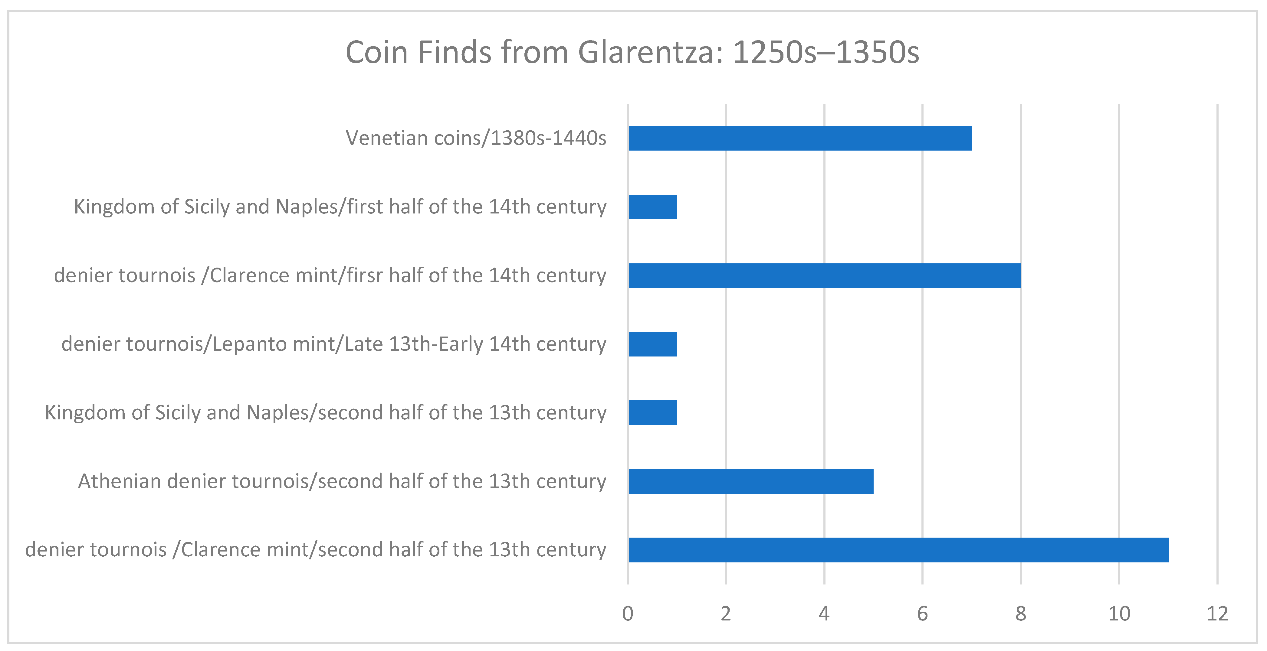
4. Economic Thought in the Byzantine Empire and the Crusader States: The Urban Economy and the Economic Structures of the Medieval Peloponnese

The main debate between the scholars exploring the Byzantine Economy and the economy of the Crusader States is whether it can be analyzed with terms of modern macroeconomics. The scholars arguing that the performance of the medieval economy in the Eastern Mediterranean cannot be studied in relation to modern economic theories are based on Finley’s study [38,39,40]. Finley states that the study of past human societies and economies should not be approached through modern economic theories suggested by sociologists and economic historians, since the people in ancient societies did not put all their economic activities under the umbrella of an organized market, where the patterns of production and distribution respond to market forces, such as transportation costs, the cost of labor, supply, and demand [40]. Moreover, according to their point of view, the state was the main agent that gathered the surplus and reallocated it to the military and civil officials, while the towns functioned as consumption centers, and the money covered the necessities of the state. On the other side, there are the scholars who give emphasis to the existence of markets, and claim that economic exchange was at the center of the state’s economy, and that money had an economic function [5,41,42,43,44]. In this aspect, as Laiou states, the economy in the Medieval Mediterranean can be viewed within the terms of modern macroeconomics, and what distinguishes it from modern economic systems is the level of advance [5] (p. 691). Carrié agrees that the distinction between the Medieval Economies and the modern ones is the rapidity of development [45]. Additionally, Laiou proposes that the three types of Polanyi’s economic integration—redistribution, reciprocity, and exchange [46] (pp. 35–36)—define not economies, but systems of exchange [47] (691–696). She also argues that there are two modes of exchange: (1) economic exchange, as has been described by Polanyi; and (2) non-economic exchange, which incorporates redistribution and reciprocity [47]. Laiou seems to think that, within a specific context, economic and non-economic exchange could have taken place in the Byzantine Empire. Temin reaches a similar conclusion, and argues that even in a market economy, there can be transactions outside the market [48].
In the 11th and 12th centuries, the basis of the economy of the Peloponnese is primary production that stimulates secondary production, thus, the regional economies of the Peloponnese are subject to primary production, and as manufacturing activities occur, interaction proliferates between them, and that is one of the main characteristics of urbanization [6] (pp. 190–208) and [49].
The archaeological record from the Peloponnese, and the limited written evidence for the attested cities of the Peloponnese present evidence for a variety of economic structures, which incorporated many different economic activities. Skilled artisans worked in various workshops specializing in ceramic, glass, and silk production; merchants offered goods, and most people were employed with agrarian activities.
Corinth functioned as the capital of the Theme of the Peloponnese from the late 8th century [50] (pp. 141–155), but was integrated into the Theme of Greece in the middle of the 11th century, with Thebes as the new capital [51] (pp. 91–92). Despite the alteration in its administrative rank, Corinth remained the administrative, trade, and economic center of the Peloponnese [51] (pp. 90–93). The systematic excavations of ancient Corinth, by the American School of Classical studies at Athens, have brought to light commercial buildings, domestic structures, workshops for ceramics, glass, and metal [52] (pp. 57–86), [53] (pp. 230–231), [54] (pp. 652–653).
Unfortunately, the rest of the port towns of the Peloponnese have limited archaeological data and written testimonies. However, industrial workshops have been identified in some of them—Patras, for example, was famous for its silk production [55] (p. 425), and ceramic workshops have been found in Argos and Sparta [56] (pp. 45–67) and [57] (pp. 233–236). Information for the city of Nauplion is also scarce, but it certainly was the commercial center of Argolid, especially after the 13th century and the coming of the Latins [58] (pp. 492, 675). It appears that shops and workshops were located in the lower part of the city of Monemvasia [14] (pp. 880–881). The only material remains from Modon and Coron are their fortifications [59] (p. 222), [60] (p.137). Domestic units and workshops have not been preserved in Modon and Coron, and the lack of systematic excavations does not allow further conclusions. Still, there is evidence proving that, at least until the early 14th century, raw silk was being produced in Modon and Coron and exported to the West [61] (pp. 28–29) and [62] (pp. 419–420). Undoubtedly, Modon and Coron played a diachronically important role in maritime trade, and functioned as two of the most significant trade hubs of the Peloponnese, particularly after their occupation by the Venetians in the 13th century [63] (p. 125).
Glarentza is the only port town that the Latins erected from scratch. The written sources attest that the city accommodated workshops, hospices, and banks, and that the most important urban and economic center of the Principality of Achaea [17] (pp. 115–116) and [64] (pp. 90–95), though the old byzantine port towns, such as Corinth, Patras, Nauplion, etc., continued to flourish [17] (pp. 125–126). Nonetheless, the erection of Glarentza in the mid-13th century, by the Latins, shifted the economic center of the Peloponnese from the northeastern NE to the northwestern NW part of the Peloponnese (Figure 2). The significance of Glarentza as the most important economic center of the Principality, is most clearly demonstrated by the existence of its own mint, which cut denier tournois from ca. 1267 to 1353 [65] (pp. 209–253) and [66] (pp. 242–248). Possible explanations for choosing this part of the peninsula to settle include the large fertile plain of Ellis, and closer proximity to their homeland. It has been argued that the fates of Patras and Glarentza, under Latin Rule, was largely due to the interests of the Republic of Venice; Venice focused all its interests on Patras from the mid-14th century onwards, and Glarenza, which was already in decline, due to the advances of the Byzantines, deteriorated [67].
The commercialization of the rural products is evident from the 11th century onwards. Olive oil was being exported, since 1088, from the ports of Corinth and Monemvasia [68] (pp. 313–321). A record from 1182 tells of a ship from Nauplion carrying around 43,000 liters of olive oil from Laconia and, heading for Constantinople, was diverted to Alexandria, instead; this suggests that during the 12th century olive oil from Laconia reached regions outside the Byzantine Empire [69] (p. 235), [70] (pp. 326–327). Olive groves and olive presses, in both Latin and Byzantine territories, are attested in the 13th and 14th centuries, and their products continued to be exported in Constantinople, Venice, and Alexandria [69] (pp. 240–243), [71] (pp. 14–15, 76–77, 136–136, 250–251). The major ports for the exports of olive oil, in the 13th and 14th centuries, were Monemvasia [14] (pp. 889–892), Modon, and Coron [69] (p. 244). Interestingly, there is no evidence of olive oil exports from Glarentza, the most important port of the Principality.
There is no information regarding cereal cultivation in the Peloponnese for the 11th and 12th centuries, but grain was important for the self-sufficiency of the population and the feeding of the oxen, sheep, goats, and horses, as well as other domesticated animals. Although there are many suitable areas in the Peloponnese for its cultivation, produce during this time most likely covered only local needs. The total lack of information indicates that this product was not exported during these two centuries. However, there is plenty of information for the 13th and 14th centuries for the Latin and Byzantine territories [71] (pp. 45, 148–1499), [72] (p. 322). Mills for grinding wheat have been documented in the whole Peloponnese during these centuries [71] (pp. 72, 135–9), [73] (p. 103). Furthermore, there is evidence for the exportation of grain. In 1271, a load of wheat left from Glarentza to Crete [74] (p. 428); in 1340, cereals were transferred from Glarentza to Venice, Ancona, and Florence [64] (p. 299); in 1344, grain was shipped from Modon to Venice [75] (pp. 412–413); and in 1355, grain was exported from Patras. Imports of grain have also been proven between the 1270s and 1280s, from Sicily to Glarentza [64] (pp. 296–298), and in 1314, from Catania to Glarentza [76] (p. 182). This evidence suggests that cereal production in the Peloponnese was mostly distributed in local markets for the 11th and 12th centuries, and its cultivation was intensified from the 13th century onwards, which allowed the exportation of its surplus on some occasions.
Jacoby [69] (p. 249) suggests that winemaking in the Peloponnese, during the 11th and 12th centuries, was a household activity, and the surplus could be distributed to those who could not reach self-sufficiency, thus promoting a small-scale wine trade within the Peloponnesian peninsula. Vineyards and viticulture were all over the Peloponnese in the 13th and 14th centuries, as testified in the Latin and Byzantine written sources [71] (pp. 132–135), [77] (pp. 109–24), [78] (pp. 186–191, 194–195). The wine that was mostly exported outside the Peloponnese was the wine from the region of Monemvasia, the so-called Malvasia [14] (p. 890), [69] (p. 253), [74] (p. 322). In general, the exporting of the Malvasia wine towards East and West is attested for in the 13th and 14th centuries [69] (pp. 253–254). Another important Peloponnesian transit center of wine is located in Glarentza, although its cultivation origins cannot be identified. It could come from the region of Ellis, or another region within the Principality. Furthermore, Modon and Coron were functioning as outlets for Peloponnesian wine, which could have been produced in Messene or elsewhere in the peninsula [60] (pp. 257–601), [69] (pp. 255–256). Hodgetts [60] (p. 258) suggests that the majority of the wine came from the plains in Messene and Achaia. Imports of wine, from Crete to the Peloponnese, have been testified in the late 13th and early 14th century in Modon [74] (p. 427), at a time that both regions were colonies of Venice.
For the 11th and 12th centuries, there are no secure data for cotton growing in the Peloponnese. According to Lefort [79] (p. 252), during these centuries, cotton was produced in Crete and Cyprus. Jacoby [69] (p. 260) also states that during the 11th and 12th centuries, the cultivation of cotton was not introduced in the Peloponnese, though he mentions that there is a reference, from 1167, of a ship having at its cargo cotton and sailing from Corinth [69] (p. 192). The first testimony of cotton production in the Peloponnese comes from 1365 in the castellania of Corinth [71] (pp. 161, 167, 178, 188–91). Moreover, Nam [80] (pp. 185–186) argues that Venice started to encourage the growing of cotton in Modon and Coron after 1350. However, there are indications that the port of Glarentza was used as a transmit point in the cotton trade from the late thirteenth century [80] (p. 244).
The significance of the secondary production in the Peloponnese, and the quality of their manufactured products in the 11th and 12th centuries, is attested through the ceramics and silk textiles. The Measles ware is considered to be a Peloponnesian production from a workshop at Corinth and/or Sparta [81] (p. 267). White, with her analytical work, has testified that the Measles wares found at Corinth are locally produced [82] (p. 109). This ware has been recorded in the Peloponnese, Italy, and Albania ([81] (p. 267) (Figure 4). Furthermore, the presence, permanent or not, of Venetian merchants, who were exporting silk textiles in the ports of Corinth and Sparta, has been testified since 1088 [83] (pp. 379–380).
Furthermore, from the late 11th century, the Peloponnese was part of the wider pottery trade system within the Eastern Mediterranean, as is attested by the vast number of imports of glazed White wares, most likely from Constantinople, Aegean, and Zeuxippus wares from unidentified workshops within the Byzantine Empire, though recent studies by Waksman and his colleagues, and Palamara and her colleagues, suggest that the majority of the Aegean wares comes from Chalkis [84,85], at Corinth [86] (pp. 385–400), Nauplion [12] (pp. 36–57) and Patras [87] (pp. 343–344) demonstrating the economic interaction of its port towns with the east. Interestingly, there are indications that the Aegean ware was also produced at Corinth, based on the wasters that were found, and the petrographic analysis conducted by White [82] (p. 115). From the mid-13th century, the majority of glazed wares belonging to Protomaiolica or Archaic Maiolica coming from Italy signify the connections of the Peloponnese with the West [12] (pp. 95–103), [13], [88] (pp. 401–422). All the material from the 13th to the mid-14th century in Glarentza and Patras originates from Italy, except for a brown glazed ware which most probably was produced in an unidentified workshop of the Islamic Anatolia [13], [89] (p. 48). Notably, at the same time, imports from Islamic Anatolia have also been recorded at Corinth [90] (pp. 168–170). The ceramic spectrum in Modon contains green and brown painted wares dating to the 12th century, slip and painted wares from the mid-12th to the mid-13th century, as well as Incised Sgraffito wares and Zeuxippus wares dating between the mid-13th to the mid-14th century [91]. Kontogiannis and Aggelopoulou [59] studied the pottery that was discovered in Modon from site-cleaning in the 1990s, and state that the fragments dating to the 13th and 14th centuries are “only a handful”, and there are no Italian imports. Unfortunately, the reports from Coron and Monemvasia do not provide secure information on their ceramic finds. According to Kalamara [92] (p. 51), there are no records of Italian imports at Monemvasia.
There are coin reports only from two of the port towns of the Peloponnese, Corinth (Figure 5), and Glarentza (Figure 6), which prove the importance of these ports in the international trade networks. According to Penna [93] (p. 212), from Corinth, more than 6000 coins have been published dating this period, as well as fourteen hoards; five of them date from the reign of Alexios I (1081–1118), one from the reign of John II (1118–1143), and five from the reign of Manuel I (1143–1180). Interestingly, three of the hoards had coins coming from non-Byzantine territories: one had 119 coins of the Bishops of Clermont, one of the Bishops du Puy, and one gold coin of Alexius I [93] (p. 212), [94] (p. 11); another hoard was found in the east parodos of the Roman theatre, and had six follis and sixty-five bronze Seljuq coins [93] (p. 212); the third hoard included nine coins from Valence, and five from Lucca [93] (p. 212), [95] (pp. 99–100). Since the Byzantine authorities allowed only the use of Byzantine issues, the concealment of these hoards does not necessarily indicate transactions with a foreign currency at Corinth. Most likely, these hoards belonged to travelers who stored their savings in times of danger [93] (p. 212). Nonetheless, the existence of these foreigner hoards affirms the international position of the city of Corinth, and its connection through maritime and trade routes with the west, the Crusader states on the Syro-Palestinian coast, and the Islamic East. From the early 13th century, the coins found at Corinth come from the West, such as English sterlings, French deniers tournois, and coins from the Kingdom of Naples, dating to the first half of the 13th century (Figure 5). From Glarentza, there are no records for French deniers tournois, and the majority of the coins were cut in its own mint [66] (pp. 271–277) (Figure 6). Venetian coinage has a strong presence in Corinth and Glarentza from the mid-14th century (Figure 5 and Figure 6), a period when the mint in Glarentza had closed, and the markets of the Peloponnese were consuming Italian ceramics [96] (pp. 170–171). It is possible that the large amounts of Venetian coinage met the need for cash during this period, resulting from the lack of coins created by closing the mint in Glarentza.
Therefore, it seems that the administrative changes with the coming of the Latins in the 13th century did not hinder the economic developments within the urban centers, commerce and manufacturing activities continued, and the exploitation of countryside was intensified [6,96]. Though, as we have seen for the 13th and 14th centuries, the records from the Peloponnese attest to the sole exportation of agricultural goods, indicating that the secondary production could not meet the requirements to supply both local and international markets. Pottery kilns and wasters, dating from the 13th century onwards, have been identified in the surveys in the Nemea Valley and Berbati Limnes [29] (pp. 48–49), [33] (pp. 406, 414–415) signifying the existence of workshops that covered the needs of the local population.
To conclude, this section presented the economic approaches for the study of the Medieval economy, as well as the various economic activities that took place in the port towns of the Peloponnese, and how they were affected by the political–territorial changes in the wider Eastern Mediterranean and the Peloponnese itself. The evidence constitutes a sample of a record of human economic behavior; nonetheless, the division of labor is apparent, and the importance of trade, manufacture, and agricultural production in the complex economic system of the medieval Peloponnese is denoted. There is primary production that exceeds local or regional demand, while the secondary production, even if it was not intended for a large industrial scale, reaches regional and international markets. Lastly, the data from the Peloponnese for the period in question support the notion of Laiou, concerning the two modes of exchange—the economic and non-economic—that can be used at the same time and place, based on the circumstances. Thus, aspects of modern market economy can be seen in the economy of the medieval Eastern Mediterranean, and the application of modern macroeconomics should be approached with great caution.

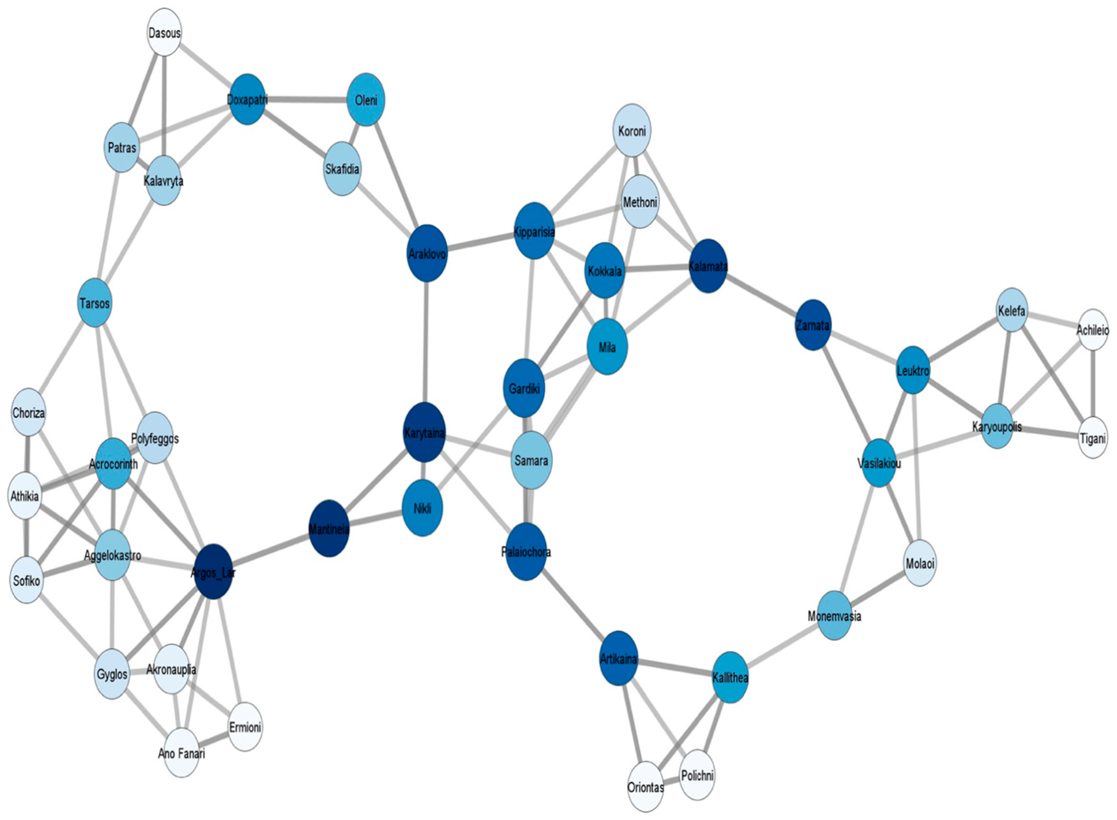
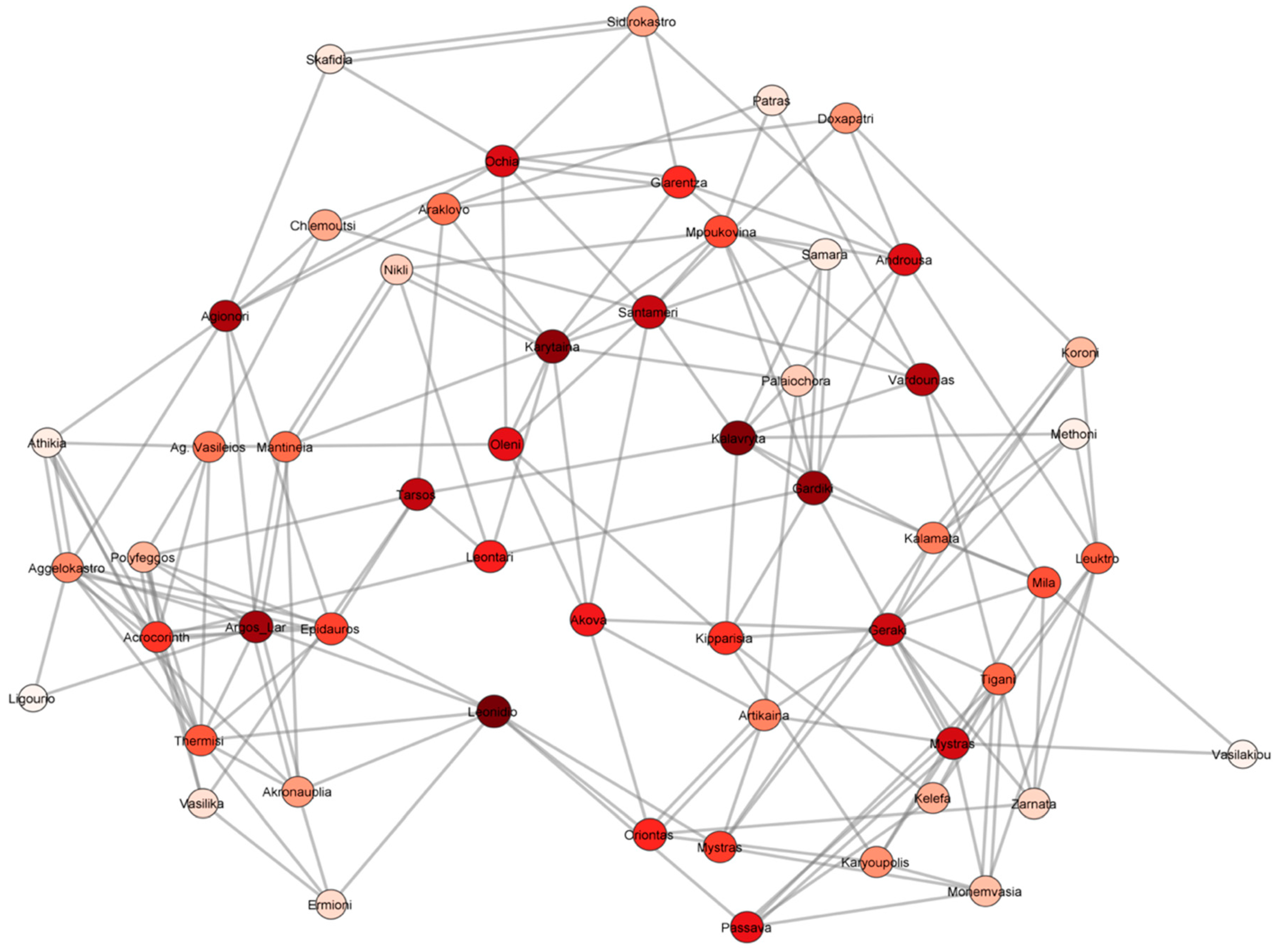
5. Networks: Closeness and Betweenness Centrality

Networks can be defined, very simply, as sets of people or things with connections between them, commonly referred to as “nodes” and “links”, respectively. The nodes used in network analysis, in this article, are the castles of the Peloponnese, since the castles were the cornerstones of the settlement system of the Medieval Peloponnese [97] (Figure 7). The links between these nodes are difficult to identify, since the limited excavation record and written sources do not provide a clear picture for all the likely connections between the sites. For this reason, I decided to use nearest-neighbor networks to demonstrate how local and regional networks are shaped between sites. The basis of the created models is the assumption that the sites interact with at least three of their nearest neighbors.
Closeness and betweenness centrality are the concepts of network theory that are applied in the created models. On the one hand, closeness centrality underlines the importance of the distance in a network, since the closeness of a node is the distance of the node to all the other nodes in the network, indicating that nodes with high closeness can get to all the other nodes of the network quicker than nodes with low closeness [98] (pp. 61–62). On the other hand, betweenness centrality highlights the number of times a node acts as bridge on the shortest path between two other nodes. Therefore, nodes with high betweenness imply their significance regarding their connection between other nodes, and their role as congestion points in the network [99] (pp. 129–130). The betweenness centrality of a node is measured by color: the bluer the node (Figure 8), the greater the betweenness centrality; the redder the node (Figure 9), the greater the betweenness centrality, while the closeness of a node is measured by size—the larger the node, the greater the closeness centrality. The models that have been created are undirected, since the links between the nodes cannot be identified. Moreover, these models are simply a mere perspective of the reality and do not depict the actual connections between the various castles, since they have been stimulated by a hypothetical scenario. However, they visualize possible interactions between the castles and the regions of the Peloponnese, and how these might change over time in the face of shifting settlement patterns.
The port towns of the Peloponnese do not control important crossroads of the road system; hence, it is not surprising that this kind of analysis shows that they played a minimal role at an interregional level. Therefore, network concepts alone cannot be used for the exploration of the hierarchy of the port towns and the reconstruction of their economic profiles. Aspects of central place theory and economic complexity can supplement these models and help us grasp the functions of the port towns and their significance in the settlements of the Peloponnese.

6. Central Place Theory and Economic Complexity

Central place theory and the relating concept of centrality was originated by Walter Christaller in 1933 [100], and was translated into English by Baskin in 1966 [101]. In simple words, a central place is a site which offers one or more services for the people leaving around it [100], [102] (p. 47). A settlement is not a prerequisite for a central place; it can also include a group of establishments that provide various products or functions to a small market [103] (p. 1307). Christaller [100] divides central places into two categories: the higher-order centers and the lower-order centers. The higher-order centers provide specialized functions (e.g., health care, public transportation, etc.), while the lower-order centers provide basic functions (market, religious institutions, etc.). Furthermore, Christaller [100] (pp. 77–83) noted that central places can be arranged into three different systems, in order to explain possible patterns of their distribution: the marketing, the transportation, and the administrative system.
Christaller’s marketing system states that the minimum number of central places that are required to function in an area is expressed as the K-3 principle. Thus, market areas are three times larger than the subsequent lower-order one [100] (pp. 77–79). The transportation system is based on the fact that the allocation of central places is generated by the main transport routes that connects them with the higher-order center, and is expressed as K-4 principle. Hence, there are four direct lower-order centers in contrast to the three linked to the marketing system [100] (pp. 79–81). In the administrative system, the markets of the lower-order centers are included within the markets of the higher-order center, and is expressed as the K-7 principle, thus, the six lower-order centers are linked to the higher-order center, and they, in turn, predominate the seven markets of the following lower level [100] (pp. 82–83). The marketing and transportation system are based on the location of a place and its immediate relation with resources, its hinterland, and maritime connectivity. The administration system is controlled by the human factor, and its efforts to concentrate as many services as possible in a center.
Nakoinz, in a recent study, investigates the diverse perceptions of central place research in archaeology [104]. According to him, central place research in archaeology can be used to identify central places, study the structure of settlement patterns, analyze the hierarchy of settlements, examine the processes of centralization of a site, and reconstruct the settlement systems of a region [104]. Moreover, Knitter’s and Nakoinz’s article, in this volume, analyses, in an explicit way, various concepts of centrality, and present methods to supplement the limitations of Christaller’s theory [105]. For this paper, in order to rank the port towns of the Medieval Peloponnese based on their centrality, and characterize them as higher-order or lower-order centers, Christaller’s central place theory is supplemented by the study of Gringmuth-Dalmer [106]. Gringmuth-Dalmer [107] (p. 8) outlines five central services that exemplify central places in premodern times: (i) administration; (ii) safety; (iii) manufacturing; (iv) commerce; and (iv) religious. The combination of central place theory with the five central services will allow the assessment of the hierarchy of these port towns, highlight their dynamics, and supplement the results of the network analysis.
Economic complexity is based on complexity theory, which studies the way that systems adjust by elucidating how the interaction between parts of the system result in collective behavior and formation, as well as how a system interplays with its environment [108] (pp. 97–104), [108] (pp. 573–601). Particularly, economic complexity in premodern societies cannot follow a strict definition or set of attributes. However, it can be used to describe the multiple interconnections of various economic structures [41]. These multiple interconnections are usually described in the form of networks [109], hence, economic complexity can be characterized as a system of networks that incorporates a variety of microscale mechanisms, which interact with each other, initiating the rise of macroscale economic behavior. These microscale mechanisms can be related with social structure, in which the components are people, institutions, and patterns of customary relationships. Institutions can signify family, religion, law, politics, or economic interactions, and are intersected and inter-reliant, and, together, represent the social hierarchy of a society [110] (pp. 63–173). Economic complexity can be used to interpret the interconnection of diverse economic activities with the three systems analyzed by Christaller, and the basic five central services of Gringmuth-Dalmer.
The use of this theoretical framework, despite its shortcomings due to the limited data, will allow us to examine the evolution of the port towns and recognize the environmental, historical, cultural, and economic processes which cause different settlements to have varied levels of centrality for the period in question, and provide an insight to the complex economic realities of the Peloponnese.

7. Discussion

The analysis of the historical processes and the economic structures of the Peloponnese indicates that some of the port towns of the Peloponnese demonstrate parallel developments, but present different degrees of centrality. In the formal central place theory [100] the higher-order centers offer specialized services to their population, and the lower-order centers basic services. It is impossible to distinguish these in pre-modern societies. Therefore, the five central services (i. administration; ii. Safety; iii. Manufacturing; iv. commerce and v. religious) of Gringmuth-Dalmer [106] will be used to understand the economic centrality of each port town. The towns that have at least four of the central services are considered to be higher-order centers, and the ones that have three or less are regarded as lower-order centers. In cases where they share the same central services, the degree of their centrality is going to be defined based on the available data, and on the way they are incorporated into the three systems identified by Christaller [100] (pp. 77–81): the administrative, marketing, and transportation system. As has been mentioned above, the data are incomplete, thus, this kind of approach provides an insight to the complex economic system of the Medieval Peloponnese and interprets the economic dynamics of each port town through concepts of centrality.
All of the port towns for the period in question are either fortified, e.g., Glarentza [81] (p. 26), or they are connected with a castle, e.g., Corinth and Acrocorinth, etc., [12] (pp. 21–24), [111] (p. 136), [112]. Therefore, all of them possess the safety service. Furthermore, all of them are ornamented with churches, offering the population the possibility to practice their faith; hence, their role in the ecclesiastical hierarchy is the variety that asserts the degree of their religious service.
During the 11th and 12th century, although Corinth was no longer the capital of a Theme, it still functioned as the administrative center of the peninsula, and also played an important part in the Orthodox Church as one of the oldest metropolises of the region [18]. Moreover, it possessed various manufacturing workshops and had commercial contacts within the Byzantine Empire, and beyond, from the 11th century onwards (Table 1). The coming of the Latins in the 13th century, and the choice to settle in the NW part of the Peloponnese, made Andravida and, later, Glarentza, the administrative center of the Principality, and caused the loss of this service from Corinth (Table 2). The Archbishop of the Catholic Church, in the Principality, had his seat in Patras, and Corinth was one of his bishoprics [113] (pp. 300–302), resulting in the diminishing of the religious service of Corinth. However, Corinth remained an important manufacturing center [114], and its port continued to flourish in the 13th and 14th centuries. The exportation of agricultural goods from its port, the imports of Italian ceramics in the city, and coin issues from various authorities that have been found at Corinth, attest that the commercial contacts and economic strength of Corinth did not deteriorate.
Nauplion owes its prosperity, during the 11th and 12th centuries, to its function as a port of the city of Argos. There is no evidence available regarding workshops in Nauplion, and the city is not a metropolitan seat. However, its port was a part of the wider trade network of the Eastern Mediterranean, as the imports of byzantine wares from regions outside the Peloponnese and its role in the exportation of Laconian oil in the late 12th century testify. In the 13th and 14th century, the degree of the trade service seems to have intensified, since there are ceramic imports from Byzantine and Italian workshops [12]. Concerning its religious centrality, there is no change attested from the 11th and 12th centuries.
The city of Patras in the 11th and 12th centuries served as a metropolis in the Orthodox Church, though on the Notitiae Episcopatum notitiae episcopatum is in a lower position than Corinth [18] (p. 42). Furthermore, there is evidence of industrial workshops, and its port was thriving due to its position in the maritime routes, thus, the city had the commerce and manufacturing service [57,89]. From the 13th century onwards, the interest of the Venetians in Patras augmented its commerce service, and there are indications that agricultural products from the Peloponnese were exported from its port, plus the ceramics found in Patras verify that the city had connections with Italy [13]. Moreover, Patras was, from the 13th century onwards, the most important religious center of the Principality, due to its upgrade to archbishopric [113] (pp. 300–302).
Monemvasia, in the 11th and 12th centuries, prospered as the main port of Laconia. Workshops and shops have been identified in the lower part of the city from the 11th century onwards. Olive oil was being exported from Monemvasia from the late 11th century, and the exportation of olive oil intensified from the 13th century onwards [14]. With the prevalence of the Byzantines in Laconia after 1261, Monemvasia was elevated to a metropolis, in fact, it was the most important metropolis of the Byzantine lands in the Peloponnese [115] (pp. 94–95), though the administrative center was Mystras. Thus, the religious service of Monemvasia was strengthened from the second quarter of the 13th century.
Modon and Coron, in the 11th and 12th centuries, had a low degree of centrality, since the central services that can be aggregated from the available data are the safety, religious, and commerce service (Table 1); this changes from the 13th century onwards, when they become the colonies of the Republic of Venice (Table 2). Their religious service is intensified, due to their promotion as bishoprics of the Catholic church. Furthermore, their commerce service is escalated, since there is secure evidence for exportation of olive oil, wine, and grain from Modon and Coron [69] (p. 244). It is difficult to clarify which of these two cities has a higher degree of centrality, since the archaeological data, especially from Coron, are scant. However, as it has been mentioned in the previous section, the written sources make references mostly to Modon, and according to Gertwagen [63] (p. 125) Modon’s location was strategically more advantageous than the one of Coron.
Glarentza is a city that was established in the mid-13th century, and owes its evolution into a major commercial transshipment port, due to the natural bay in the area and the rise in political importance of the northwestern part of the Peloponnese. Glarentza gradually became the administrative center of the Principality, and its commerce service is highlighted by the imports and exports of agricultural goods, the vast numbers of Italian ceramics discovered in the city, the existence of a mint that cut deniers tournois, as well as the coins found from other various authorities that have been recorded [89].
From the above analysis, there are some points that can be extracted. There is no doubt that, for the 11th and 12th centuries, Corinth has the highest degree of centrality from all the port towns of the Peloponnese, since it integrates all five central services, and all three systems of Christaller’s are combined in the city’s function. Therefore, Corinth is considered to be a higher-order central place. The second port town hierarchically in centrality is Patras, which is also considered as a higher-order central place as it covers four of the central services: the safety, commerce, manufacturing, and religious service. Patras comes second because it lacks the administration service, and is in a lower position of Corinth in the ecclesiastical hierarchy of the Orthodox Church. Monemvasia is also a higher-order place, since it shares the same services with Patras. However, Monemvasia is not a metropolis, hence, it comes third in rank because its religious service is lower than the one of Patras. The rest of the port towns of the Peloponnese can be characterized as lower-order central places, because they meet three of the central services. Nauplion, Modon, and Coron hold the safety, commerce, and religious service, but Nauplion has a higher degree of the commerce service, since its port was used for the exportation of olive oil in lands outside the Byzantine Empire. Thus, Nauplion follows Monemvasia in the hierarchy and, in the last two positions, there are Modon and Coron, respectively. Lastly, Patras, Nauplion, Modon, and Coron combine two of Christaller’s system, the marketing and transportation (Table 1).
The sociopolitical changes in the Peloponnese and the eastern Mediterranean caused the reorganization of economic networks, and the urban spaces of the Peloponnese needed to adapt to the new conditions. The emergence of Glarentza, and the reorganization of the religious institutions by the Catholic church, as well as the predominance of the Byzantines in Laconia, triggered changes in their central services and the degrees of centrality of the port towns of the Peloponnese. There are four port towns that can be regarded as higher-order centers: Glarentza, Patras, Monemvasia, and Corinth (Table 2).
Glarentza is now first in the hierarchy because it covers all five basic services, and possesses all three systems of the central place theory, while all the rest port towns of the Peloponnese integrate only the marketing and transportation system. The archbishopric of the Catholic Church is in Patras; hence, Patras has the highest degree of the religious service. However, it comes second in rank because it lacks the administration service, and combines only two of Christaller’s system. Monemvasia comes third in rank, though it covers the same central services as Patras (Table 2) and they both share the same degree of the religious service, since it has become the most important Orthodox metropolis of the Peloponnese. They both function as important ports, and are used for the exportation of the agricultural goods of the Peloponnese, but it seems that Monemvasia is not part of the pottery trade network of the 13th and 14th century, due to the lack of ceramic imports from the West and East; thus, Monemvasia’s commerce service is in a lower level than the one of Patras. Furthermore, when looking at the urban topography of the Peloponnese as a whole, Monevmasia holds the third position, but in the region of the Peloponnese occupied by the Byzantines, it has the second position after Mistras, which serves as the administration center of the Despotate of Mistras. Corinth continues to be a higher-order center covering four of the five basic services, but now it ranks fourth. Corinth lacks the administration service, and its religious service is in a lower position than the one of Patras and Monemvasia. Modon, Coron, and Nauplion integrate three of the five central services, thus, they are characterized as lower-order centers. Modon and Coron are above Nauplion because their churches have been upgraded to bishoprics of the Catholic Church, making their religious services higher than the one of Nauplion (Table 2).
Interestingly, in the mid-14th century, the political–territorial organization of the Peloponnese was altered once again. The Byzantines managed to expand their territories, and the Principality of Achaea was then limited to the northwestern part of the Peloponnese. It seems that the majority of the port towns of the Peloponnese managed to adjust, but Glarentza gradually fell into ruin. Its location was appropriate for the founding of a port town, but it took the political initiative of the Principality of Achaea for Glarentza to become its administrative and economic center. The loss of that role, due to the political deterioration of the Principality and the refocusing of interests of the Venetians to Patras, caused the decline and the gradual abonnement of the city. Thus, the human factor had a vital role in Glarentza’s fate. The other port towns of the Peloponnese were definitely affected by the sociopolitical changes in the Peloponnese and in the wider eastern Mediterranean, but it seems that they were able to adapt, and although their central services were altered, they did not deteriorate completely.

8. Conclusions

The port towns of the Peloponnese diachronically linked the peninsula with regions within the Byzantine Empire and beyond. They were located in strategic locations, since they could reach distant markets and obtain objects and goods from regions outside the peninsula, but they were also connected with the resources of their hinterlands. The commercialization of the rural products and the investigation of the ceramic spectrum of the Peloponnese, in juxtaposition with the single coin finds and the identification of manufacturing workshops, wherever possible, reflected the size and dynamics of their markets, and signified the opportunities for specialization in the division of labor. The analysis of their economic structures resulted in the description of their economic profiles and elucidated their resemblances and differences. Aspects of network analysis highlighted the possible connections of the castles and the regions of the Peloponnese, though the created models could not demonstrate the centrality of the port towns of the Peloponnese, due to their location away from the main crossroads of the Peloponnese. The limitations of these models were supplemented by concepts of central place theory in association with the Gringmuth-Dalmer’s five central services. The interpretation of the port towns of the Peloponnese, with concepts of centrality, highlighted the services that they offered in their inhabitants and their hinterlands, and suggested their importance in the economic topography of the Peloponnese before and after the coming of the Latins in 1204. To sum up, this kind of approach provided the qualitative analysis of the economic centrality of the port towns of the Peloponnese, elucidated aspects of their complex economic systems, and allowed the diachronic evaluation of their economic profile.

Funding

This research received no external funding.

Acknowledgments

I would like to thank the editors of this volume for giving me the chance to publish aspects of my research in this volume.

Conflicts of Interest

The author declares no conflict of interest.

References

  1. Lemerle, P. Cinq études sur le XIe siècle byzantine; Centre National de la Recherche Scientifique: Paris, France, 1977; ISBN 2-222-02053-0. [Google Scholar]
  2. Laiou, A.E. Byzantine Trade with Christians and Muslims and the Crusades. In The Crusades from the Perspective of Byzantium and the Muslim World; Laiou, A.E., Mottahedeh, R.P., Eds.; Dumbarton Oaks Research Library and Collection: Washington, DC, USA, 2001; pp. 157–196. ISBN 9780884022770. [Google Scholar]
  3. Angold, M. Belle epoque or crisis? (1025–1118). In The Cambridge History of Byzantine Empire c. 500–1492; Shepard, J., Ed.; Cambridge University Press: Cambridge, UK, 2008; pp. 583–626. ISBN 978-0-521-83231-1. [Google Scholar]
  4. Laiou, A.E. The Palaiologoi and the world around them (1261–1400). In The Cambridge History of Byzantine Empire c. 500–1492; Sheppard, J., Ed.; Cambridge University Press: Cambridge, UK, 2008; pp. 803–833. ISBN 978-0-521-83231-1. [Google Scholar]
  5. Laiou, A.E. Exchange and Trade, Seventh-Twelfth Centuries. In The Economic History of Byzantium III; Laiou, A.E., Ed.; Dumbarton Oaks: Washington, DC, USA, 2002; pp. 697–770. ISBN 0-88402-288-9. [Google Scholar]
  6. Jacoby, D. The Economy of Latin Greece. In Companion to Latin Greece; Tsougarakis, I.N., Lock, P., Eds.; Brill: Leiden, The Netherlands, 2015; pp. 185–216. ISBN 978-90-04-28402-9. [Google Scholar]
  7. Geyer, B. Physical Factors in the Evolution of Landscape and Land Use. In The Economic History of Byzantium I; Laiou, A.E., Ed.; Dumbarton Oaks: Washington, DC, USA, 2002; pp. 31–45. ISBN 0-88402-288-9. [Google Scholar]
  8. Campbell, B. The Great Transition: Climate, Disease and Society in the Late Medieval World; Cambridge University Press: Cambridge, UK, 2016; ISBN 978-0-521-14443-8. [Google Scholar]
  9. Weiberg, E.; Unkel, I.; Kouli, K.; Holmgren, K.; Avramidis, P.; Bonnier, A.; Dibble, F.; Finné, M.; Izdebski, A.; Katrantsiotis, C.; et al. The socio-environmental history of the Peloponnese during the Holocene: Towards an integrated understanding of the past. Quat. Sci. Rev. 2016, 136, 40–65. [Google Scholar] [CrossRef]
  10. Jones, A.; Montanareall, L.; Jones, R. Soil Atlas of Europe; European Commission: Brussels, Belgium, 2006. [Google Scholar]
  11. Dieten, L. Niketas Choniates. Erlauterungzu den Reden und Briefennebsteiner Biographie; Walter de Gruyter: Berlin, Germany, 1975. [Google Scholar]
  12. Yangaki, A. Εφυαλωμένη Κεραμική από τη Θέση Άγιοι Θεόδωροι στην Aκροναυπλία (11ος-17ος αι.); The National Hellenic Research Foundation: Athens, Greece, 2012; ISBN 978-960-9538-09-1. [Google Scholar]
  13. Vasilakis, N. Εισηγμένη ιταλική κεραμική στην Πάτρα (13ος-18ος αιώνας). Delt. Christ. Archaiol. Etair. 2015, 36, 305–324. [Google Scholar]
  14. Kalligas, H. Monemvasia, Seventh-Fifteenth Centuries. In The Economic History of Byzantium III; Laiou, A.E., Ed.; Dumbarton Oaks Research Library and Collection: Washington, DC, USA, 2002; pp. 879–897. ISBN 0-88402-288-9. [Google Scholar]
  15. Gerstel, S.E.J. The Morea. In Heaven and Earth: Art of Byzantium from Greek Collections; Drandaki, A., Papanikola-Bakirtzi, D., Tourta, A., Eds.; Hellenic Ministry of Culture and Sports and the Benaki Museum: Athens, Greece, 2013; pp. 300–304. ISBN 978-960-476-130-2. [Google Scholar]
  16. Lock, P. The Franks in the Aegean, 1204–1500; Longman: London, UK, 1995; ISBN 978-1138836327. [Google Scholar]
  17. Athanasoulis, D. The Triangle of Power: Building Projects in the Metropolitan Area of the Crusader Principality of the Morea. In Viewing the Morea. Land and People in the Late Medieval Peloponnese; Gerstel, S.E.J., Ed.; Dumbarton Oaks Research Library and Collection: Washington, DC, USA, 2013; pp. 111–152. ISBN 978-0-88402-390-6. [Google Scholar]
  18. Darrouzès, J. Notitiae Episcopatum Ecclesia Constantinopolitanae. Géographie Ecclésiastique de l’ Empire Byzantin; Centre National de la Recherche Scientifique: Paris, France, 1981; Volume 1. [Google Scholar]
  19. Jaubert, P.A. La Géographie d’ Edrisi; Imprimerie Royale: Paris, France, 1840. [Google Scholar]
  20. Rodd, R. The Princes of Achaia and the Chronicles of Morea. A Study of Greece in the Middle Ages; Longmans, Green, and Company: London, UK, 1907. [Google Scholar]
  21. Kontogiannis, N. Settlements and Countryside of Messenia during the Late Middle Ages: The testimony of Fortifacations. In Byzantine and Modern Greek Studies; University of Birmingham: Birmingham, UK, 2010; Volume 34, pp. 3–29. [Google Scholar]
  22. Zakythinos, D.A. Le Despotat grec de Morée. Histoire Politique; édition revue et augmentée par Chryssa Maltézou, Variorum Reprints: London, UK, 1975. [Google Scholar]
  23. Bon, A. La Morée Franque Recherches historiques, Topographiques et archéologiques sur la Principauté d’Achaïe (1205–1430); E. de Boccard: Paris, France, 1969. [Google Scholar]
  24. Longnon, J. L’Empire Latin de Constantinople et la Principauté de Morée; Payot: Paris, France, 1949. [Google Scholar]
  25. Kalopissi-Verti, S. Mistra. A Fortified Late Byzantine Settlement. In Heaven and Earth. Cities and Countryside in Byzantine Greece; Albani, J., Chalkia, E., Eds.; Hellenic Ministry of Culture and Sports and Benaki Museum: Athens, Greece, 2013; pp. 224–239. ISBN 978-960-476-132-6. [Google Scholar]
  26. Runnels, C.N.; Van Andel, T.H. The Evolution of Settlement in the Southern Argolid, Greece. An Economic Explanation. Hesperia 1987, 56, 303–334. [Google Scholar] [CrossRef]
  27. Mee, C.; Forbes, H. A Rough and Rocky Place: Landscape and Settlement History of the Methana Peninsula, Greece; Liverpool University Press: Liverpool, UK, 1997; ISBN 9780853237419. [Google Scholar]
  28. Tartaron, T.F.; Gregory, T.E.; Pullen, D.J.; Noller, J.S.; Rothaus, R.M.; Rife, J.L.; Tzortzopoulou-Gregory, L.; Schon, R.; Caraher, W.R.; Pettegrew, D.K.; et al. The Eastern Korinthia Archaeological Survey: Integrated Methods for a Dynamic Landscape. Hesperia 2006, 75, 453–523. [Google Scholar] [CrossRef]
  29. Athanassopoulos, E. Landscape Archaeology and the Medieval Countryside; The American School of Classical Studies at Athens: Princeton, NJ, USA, 2016; ISBN 9780876619230. [Google Scholar]
  30. Forsén, J.; Forsén, B. The Asea valley Survey. An Arcadian Mountain Valley from the Palaelithic Period Until Modern Times; Svenska Institutet i Athen: Stockholm, Sweden, 2003; ISBN 9789179160470. [Google Scholar]
  31. Armstrong, P. The Survey Area in the Byzantine and Ottoman Periods. In Continuity and Change in a Greek Rural Landscape: The Laconia Survey, Methodology and Interpretation; Cavanagh, W., Crouwel, J., Catling, R.W.V., Shipley, G., Armstrong, P., Fiselier, J., Rackham, O., van Berghem, J.-W., Wagstaff, M., Eds.; British School at Athen: London, UK, 2003; pp. 339–402. ISBN 0-904887-22-7. [Google Scholar]
  32. Davis, J.L.; Alcock, S.E.; Bennet, J.; Lolos, Y.G.; Shelmerdine, C.W. The Pylos Regional Archaeological Project Part I. Overview and the Archaeological Survey. Hesperia 1997, 66, 391–494. [Google Scholar] [CrossRef]
  33. Hahn, M. The Early to Modern Periods. In The Berbati-Limnes Archaeological Survey 1988-1990; Wells, B., Runnels, C., Eds.; Astrom Editions: Stockholm, Sweden, 1996; pp. 345–351. [Google Scholar]
  34. Leake, W.M. Travels in the Morea; John Murray: London, UK, 1830. [Google Scholar]
  35. Gell, W. Itinerary of the Morea: Being a Description of the Routes of the Peninsula; Rodwell and Martin: London, UK, 1817. [Google Scholar]
  36. Sanders, G.D.R.; Whitbread, I.K. Central Places and Major Roads in the Peloponnese. Annu. Br. Sch. Athens 1990, 85, 333–361. [Google Scholar] [CrossRef]
  37. Kourelis, K. Zaraka Surrounded: The Archaeology of Settlements in the Peloponnesian Countryside. In The Cistercian Monastery of Zaraka, Greece; Campbell, S., Ed.; Medieval Institute Publication: Kalamazoo, Michigan, 2018; pp. 193–213. ISBN 978158044244-2. [Google Scholar]
  38. Patlagean, E. Byzance et les Marchés du Grand Commerce, vers 830-vers 1030: Entre Pirenne et Polanyi. In Mercati e Mercanti nell’alto medioveo: L’area Euroasiatiaca e l’ area Mediterranean; Settimane di Studio del Centro Italiano di Studi Sull’alto Medioevo: Spoleto, Italy, 1993; pp. 586–632. ISBN 88-7988-039-X. [Google Scholar]
  39. Hendy, M.F. Studies in the Byzantine Monetary Economy, c. 300–1450; Cambridge; University Press: Cambridge, UK, 1985; ISBN 0521247152. [Google Scholar]
  40. Finley, M.I. Economy and Society in Ancient Greece; Viking Press: London, UK, 1982; ISBN 9782020146449. [Google Scholar]
  41. Lopez, R.S. The Role of Trade in the Economic Readjustment of Byzantium in the Seventh Century. Dumbart. Oaks Pap. 1953, 13, 67–85. [Google Scholar] [CrossRef]
  42. Oikonomides, N. The Role of the Byzantine State in the Economy. In The Economic History of Byzantium III; Laiou, A.E., Ed.; Dumbarton Oaks Research Library and Collection: Washington, DC, USA, 2002; pp. 951–1036. ISBN 0-88402-288-9. [Google Scholar]
  43. Laiou, A.E. Byzantium and the Commercial Revolution. In Europa Medievale e mondo Bizantino; Arnaldi, G., Cavallo, G., Eds.; Nella sede dell’ Istituto Palazzo Borromini: Rome, Italy, 1997; pp. 239–253. [Google Scholar]
  44. Morrisson, C. Weighing, Measuring, Paying Exchanges in the Market and the Marketplace. In Trade and Markets in Byzantium; Morrisson, C., Ed.; Dumbarton Oaks Research Library and Collection: Washington, DC, USA, 2012; pp. 333–378. ISBN 9780884023777. [Google Scholar]
  45. Carrié, J.M. Were Later Roman and Byzantine Economies Market Economies? A Comparative Look at Historiography. In Trade and Markets in Byzantium; Morrisson, C., Ed.; Dumbarton Oaks Research Library and Collection: Washington, DC, USA, 2012; pp. 13–26. ISBN 9780884023777. [Google Scholar]
  46. Polanyi, K. The Livelihood of Man; Academic Press: New York, NY, USA, 1977; ISBN 9780125481502. [Google Scholar]
  47. Laiou, A.E. Economic and Noneconomic Exchange. In The Economic History of Byzantium II; Laiou, A.E., Ed.; Dumbarton Oaks Research Library and Collection: Washington, DC, USA, 2002; pp. 681–696. ISBN 0-88402-288-9. [Google Scholar]
  48. Temin, P. Byzantine Trade, Summary and Prospect. In Trade and Markets in Byzantium; Morrisson, C., Ed.; Dumbarton Oaks Research Library and Collection: Washington, DC, USA, 2012; pp. 429–436. ISBN 9780884023777. [Google Scholar]
  49. Braudel, F. Civilisation matérielle, économie et capitalisme, XVe-XVIIIe siècle; Armand Colin: Paris, France, 1979; ISBN 978-2253064558. [Google Scholar]
  50. Zivkovic, T. The Date of the Creation of the Theme of the Peloponnese. Byzantina Symmeikta 1999, 13, 141–155. [Google Scholar] [CrossRef]
  51. Bon, A. Le Péloponnése Byzantin jusqu’en 1204; Presses Universitaires de France: Paris, France, 1951. [Google Scholar]
  52. Scranton, L.R. Medieval Architecture in the Central Area of Corinth; American School of Classical Studies at Athens: Athens, Greece, 1957. [Google Scholar]
  53. Robinson, H.S.; Weinberg, S.S. Excavations at Corinth. Hesperia 1960, 31, 95–133. [Google Scholar] [CrossRef]
  54. Sanders, G.D.R. Corinth. In The Economic History of Byzantium II; Laiou, A.E., Ed.; Dumbarton Oaks Research Library and Collection: Washington, DC, USA, 2002; pp. 647–654. [Google Scholar]
  55. Jacoby, D. Silk Production. In Oxford Handbook of Byzantine Studies; Jeffreys, E., Haldon, J., Cormack, R., Eds.; Oxford University Press: Oxford, UK, 2008; pp. 421–428. ISBN 9780191743528. [Google Scholar]
  56. Papanikola-Bakirtzis, D. Εργαστήρια Εφυαλωμένης Κεραμικής στον Βυζαντινό Κόσμο. In VIIe Congrès International sur la céramique médiévale en Méditerranée; Bakirtzis, C., Ed.; La Caisse des Recettes Arcéologiques: Athens, Greece, 2003; pp. 45–66. ISBN 96021405779789602140574. [Google Scholar]
  57. Bakourou, A.; Katsara, E.; Kalamara, P. Argos and Sparta of the 12th and 13th centuries. In VIIe Congrès International sur la céramique médiévale en Méditerranée; Bakirtzis, C., Ed.; La Caisse des Recettes Arcéologiques: Athens, Greece, 2003; pp. 233–236. ISBN 96021405779789602140574. [Google Scholar]
  58. Thiriet, F. La Romanie Vénetienne au Moyen Age. Le Développement et l’Exploitation du domaine Colonial Vénitien (XIIe-XVe Siècles); E. de Boccard: Paris, France, 1959. [Google Scholar]
  59. Kontogiannis, N.; Aggelopoulou, I. Venetian City of Modone in SW Peloponnese: The Archaeological Evidence. In The Heritage of Serenissima, The Presentation of the Architectural and Archaeological Remains of the Venetian Republic, Proceedings of the International Conference, Izola-Venezia 4-9.11.2005; Gustin, M., Gelichi, S., Spindler, K., Eds.; Annales Mediterranea, Koper: Venice, Italy, 2006; pp. 221–228. ISBN 9789616328395. [Google Scholar]
  60. Hodgetts, A.C. The Colonies of Coron and Modon under Venetian Administration, 1204–1400. Unpublished Ph.D. Thesis, University of London, London, UK, 1974. [Google Scholar]
  61. Jacoby, D. Silk Production in Frankish Greece. In Τεχνογνωσία στην Λατινοκρατούμενη Ελλάδα; Cultural Technological Foundation: Athens, Greece, 2000; pp. 22–35. ISBN 960-244-055-4. [Google Scholar]
  62. Ciasca, R. L’Arte dei Medici e Speziali nella storia e nel comercio fiorentino dal secolo XII al XV; Biblioteca Storica Toscana: Florence, Italy, 1927; ISBN 8822222695. [Google Scholar]
  63. Gertwagen, R. Venetian Modon and its Port (1358–1500). In The Mediterranean Urban Culture; Cowan, A., Ed.; Exeter Univeristy Press: Exeter, UK, 2000; pp. 125–148. ISBN 9780859895781. [Google Scholar]
  64. Tzavara, A. Clarentza: Une ville de la Morée latine, XIIIe–XVe Siècle; Institut hellénique d’etudes byzantines et post-byzantines de Venise: Venice, Italy, 2008; ISBN 9788890075469. [Google Scholar]
  65. Baker, J.; Ponting, M. The Early Period of Minting of Deniers Tournois in the Principality of Achaϊa (to 1289), and their Relation to the Issues of the Duchy of Athens. Numis. Chronicle 2001, 161, 207–254. [Google Scholar]
  66. Athanasoulis, D.; Baker, J. Medieval Glarentza: The Coins 1999–2004, with additional Medieval Coin Finds from the nomos of Ellis. Numis. Chronicle 2008, 168, 241–301. [Google Scholar]
  67. Schmitt, O.J. Zur Gesichte der Stadt Glarentza im 15 Jahrhundert. Byzantion 1995, 65, 98–135. [Google Scholar]
  68. Armstrong, P. Merchants of Venice at Sparta in the 12th Century. In Sparta and Laconia: From Prehistory to Pre-Modern; Cavanagh, W.G., Gallou, C., Georgiadis, M., Eds.; British School at Athens: London, UK, 2009; pp. 313–321. ISBN 9780904887617. [Google Scholar]
  69. Jacoby, D. Rural Exploitation and Market Economy in the Late Medieval Peloponnese. In Viewing the Morea. Land and People in the Late Medieval Peloponnese; Gerstel, S.E.J., Ed.; Dumbarton Oaks Research Library and Collection: Washington, DC, USA, 2013; pp. 213–276. ISBN 978-0-88402-390-6. [Google Scholar]
  70. Morozzo della Rocca, R.; Lombardo, A. Documenti del Commercio Veneziano nei secoli XI–XIII; Editrice Libraria Italiana: Turin, Italy, 1940. [Google Scholar]
  71. Longnon, J.; Topping, P. Documents sur le Régime des Terres dans la Principauté de Morée au XIV Siècle; Mouton: Paris, France, 1969. [Google Scholar]
  72. Laiou, A.E. The Agrarian Economy, 13th–15th Centuries. In The Economic History of Byzantium I; Laiou, A.E., Ed.; Dumbarton Oaks Research Library and Collection: Washington, DC, USA, 2002; pp. 311–375. ISBN 0-88402-288-9. [Google Scholar]
  73. Millet, G. Inscriptions Byzantines de Mistra. Bulletin Correspondance Hellénique BCH 1899, 23, 97–156. [Google Scholar] [CrossRef]
  74. Morgan, G. The Venetians Claims Commission of 1278. Byzantinische Z. 1976, 69, 411–438. [Google Scholar] [CrossRef]
  75. Jacoby, D. Un Aspect de la Fiscalité Vénitienne dans le Péloponnèse aux XIVe et XVe Siècles: Le Zovaticum. In Trauvaux et Mémoires du Centre de Recherche d’Histoire et Civilisation Byzantines; E. de Boccard: Paris, France, 1965; Volume 1, pp. 405–420. [Google Scholar]
  76. Krekic, B. Dubrovnik (Raguse) et le Levant au moyen âge; Mouton: Paris, France; The Hague, The Netherlands, 1961. [Google Scholar]
  77. Panopoulou, A.; Papakosma, K. Aμπελοκαλλιέργεια και παραγωγή κρασιού στη δυτική Πελοπόννησο (13ος-15ος αι.). In Επιστημονικό Συμπόσιο «Oἶνον ἱστορῶ». Aμπελοοινική ιστορία και αρχαιολογία της ΒΔ Πελοπόννησου, Κτήμα Μερκούρη, Κορακοχώρι Hλείας; The National Hellenic Research Foundation: Athens, Greece, 2001; pp. 109–124. ISBN 9608702305. [Google Scholar]
  78. Gerland, A.E. Neue Quellen zur Geschichte des lateinischen Erzbistums Patras; Teubner: Leipzig, Germany, 1903. [Google Scholar]
  79. Lefort, J. The Rural Economy, 7th–12th Centuries. In The Economic History of Byzantium I; Laiou, A.E., Ed.; Dumbarton Oaks Research Library and Collection: Washington, DC, USA, 2002; pp. 231–310. ISBN 0-88402-288-9. [Google Scholar]
  80. Nam, J.K. Le commerce du coton en Méditerranée à la fin du Moyen Age; Brill: Leiden, The Netherlands, 2007; ISBN 9789004162266. [Google Scholar]
  81. Sanders, G.D.R. Excavations at Sparta: The Roman Stoa, 1988–1991. Preliminary Report, Part 1, (c) Medieval Pottery. BSA 1993, 88, 251–286. [Google Scholar]
  82. White, H.E. An Investigation of Production Technologies of Byzantine Glazed Pottery from Corinth, Greece in the 11th and 13th Centuries. Unpublished Ph.D. Thesis, University of Sheffield, Sheffield, UK, 2009. [Google Scholar]
  83. Jacoby, D. Venetian Commercial Expansion in the Eastern Mediterranean, 8th–12th Centuries. In Byzantine Trade, 4th–12th Centuries. The Archaeology of Local, Regional and International Exchange. Papers of the Thirty-Eighth Spring Symposium of Byzantine Studies, St John’s College, University of Oxford, March 2004; Mundell-Mango, M., Ed.; Ashgate Publishing Ltd: Farnham, UK, 2009; pp. 371–392. ISBN 978-0754663102. [Google Scholar]
  84. Waksman, S.Y.; Kontogiannis, N.D.; Skartsis, S.S.; Vaxevanis, G. The Main “Middle Byzantine Production” and Pottery Manufacture Center in Thebes and Chalkis. Annu. Br. Sch. Athens 2014, 109, 379–422. [Google Scholar] [CrossRef]
  85. Palamara, E.; Zacharias, N.; Xanthopoulou, M.; Kasztovszky, Z.; Kovács, I.; Palles, D.; Kamitsos, E.I. Technology Issues of Byzantine Glazed Pottery from Corinth, Greece. Microchem. J. 2016, 129, 137–150. [Google Scholar] [CrossRef]
  86. Sanders, G.D.R. Recent Developments in the Chronology of Byzantine Corinth. In Corinth XX; Williams, C.K., Bookidis, N., Eds.; American School of Classical Studies at Athens: Princeton, NJ, USA, 2003; pp. 385–399. ISBN 978-0876610206. [Google Scholar]
  87. Athanasoulis, D. Μεσοβυζαντινό Ναΐδριο στην Πάτρα και η Ένταξη του στη Μεσαιωνική Πόλη. Archaiologiko Deltion 2002, 53, 331–360. [Google Scholar]
  88. MacKay, T.S. Pottery of the Frankish Period: 13th and Early 14th Century. In Corinth XX; Williams, C.K., Bookidis, N., Eds.; American School of Classical Studies at Athens: Princeton, NJ, USA, 2003; pp. 385–400. ISBN 978-0876610206. [Google Scholar]
  89. Athanasoulis, D. Γλαρεντζα/Clarence; Hellenic Ministry of Culture: Athens, Greece, 2005; ISBN 960-214-485-8. [Google Scholar]
  90. Morgan, C. Corinth Results of Excavations Conducted by the American School of Classical Studies at Athens: The Byzantine Pottery XI; Harvard University Press: Cambridge, MA, USA, 1942. [Google Scholar]
  91. Pallas, D. Eρευναι ἐν Μεθώνῃ. Praktika Archaiologikis Etaireias 1971, 124, 78–97. [Google Scholar]
  92. Kalamara, P. Tα Aεραμικά. In Monemvasia, antikeimena—Perivallon—Istoria. I archaiologiki syllogi; Evgenidou, D., Ed.; Hellenic Ministry of Culture: Athens, Greece, 2001; pp. 40–59. [Google Scholar]
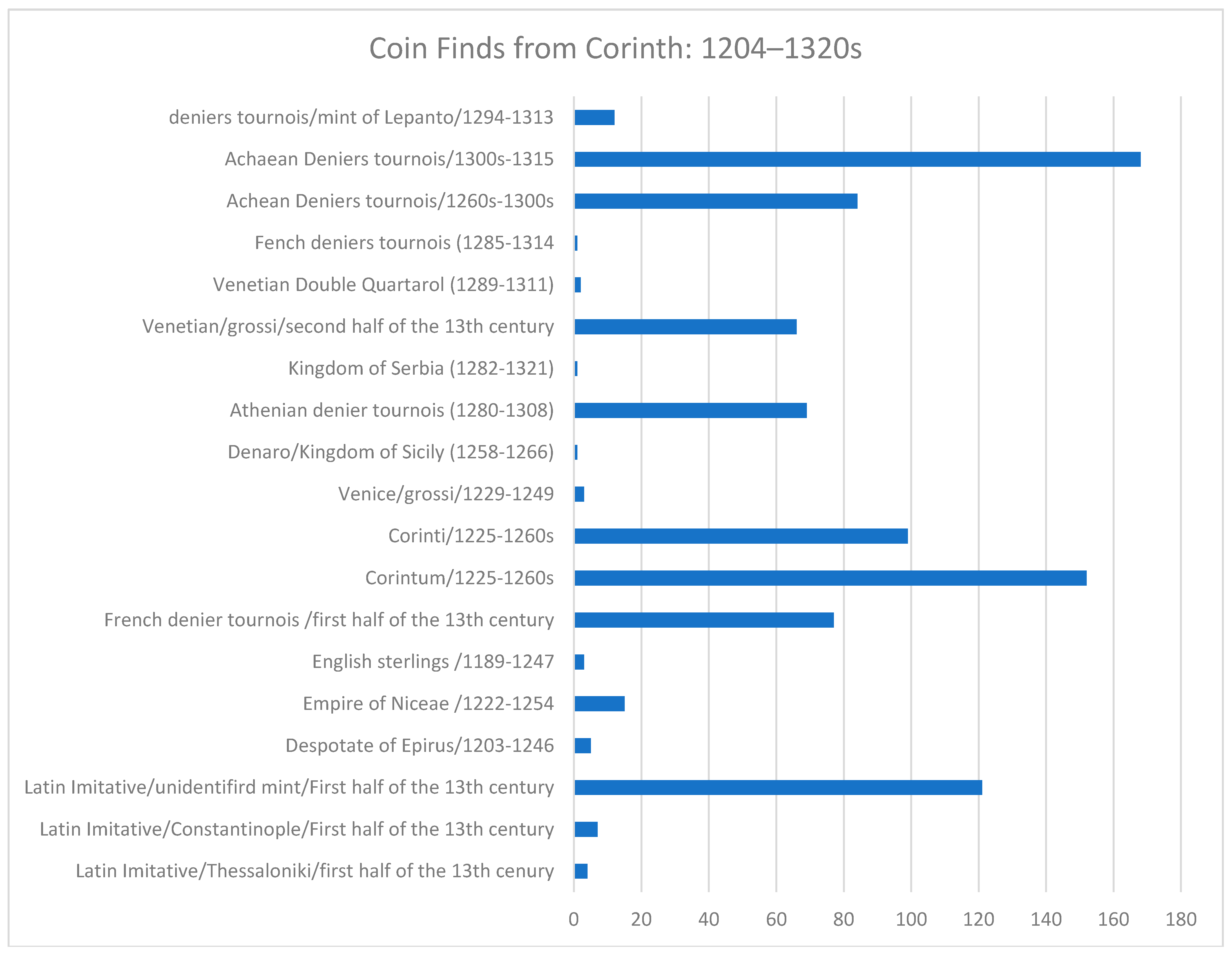
  93. Penna, V.H. Zωή στις Bυζαντινές Πόλεις της Πελοποννήσου: H Nομισματική Μαρτυρία. In Μνήμη Martin Jessop Price; Tzamalis, A.P., Ed.; Hellenic Numismatic Society: Athens, Greece, 1996; pp. 195–288. ISBN 960-85522-5-7. [Google Scholar]
  94. Edwards, K.M. Corinth VI Coins 1896–1923; Harvard University Press: Cambridge MA, USA, 1933. [Google Scholar]
  95. Metcalf, D.M. Coinage in South-Eastern Europe 820–1936; Royal Numismatic Society: London, UK, 1979; ISBN 978-618-82459-4-5. [Google Scholar]
  96. Baker, J.; Stahl, A. Coinage and Money in the Morea after the 4th Crusade. In Viewing the Morea. Land and People in the Late Medieval Peloponnese; Gerstel, S.E.J., Ed.; Dumbarton Oaks Research Library and Collection: Washington, DC, USA, 2013; pp. 153–186. ISBN 978-0-88402-390-6. [Google Scholar]
  97. Ragkou, K. Eastern Mediterranean Economic Networks in the Age of the Crusades (late 11th to mid-14th Centuries): The Case of the Peloponnese. Unpublished Ph.D. Thesis, University of Cologne, Cologne, Germany, 2017. [Google Scholar]
  98. Isaksen, L. “O What a Tangled Web We Weave”–Towards a Practice that does not Deceive. In Network Analysis in Archaeology: New Approaches to Regional Interaction; Knappett, C., Ed.; Oxford University Press: Oxford, UK, 2013; pp. 43–70. ISBN 9780199697090. [Google Scholar]
  99. Rivers, R.; Knappet, C.; Evans, T. What makes a site important? Centrality, gateways and gravity. In Network Analysis in Archaeology: New Approaches to Regional Interaction; Knappett, C., Ed.; Oxford University Press: Oxford, UK, 2013; pp. 125–150. ISBN 9780199697090. [Google Scholar]
  100. Christaller, W. Die Zentralen Orte in Süddeutschland.über die Gesetzmässigkeit der Verbreitung und Entwicklung der Siedlungen mit städtischen Funktionen; Gustav Fischer: Jena, Germany, 1933; ISBN 9783534197361. [Google Scholar]
  101. Christaller, W. Central Places in Southern Germany; Prentice-Hall: Englewood Cliffs, NJ, USA, 1966; ISBN 978-0131226302. [Google Scholar]
  102. Knitter, D.; Nakoinz, O.; del Fabbro, R.; Kohlmeyer, K.; Schütt, B.; Meyer, M. The Centrality of Aleppo and its Environs. eTopoi J. Anc. Stud. 2014, 3, 107–127. [Google Scholar]
  103. Blotevogel, H.H. Zentrale Orte. In Handwörterbuch der Raumordnung; Ritter, E.H., Ed.; Akademie für Raumforschung und Landesplanung: Hannover, Germany, 2005; pp. 1307–1315. ISBN 9783888385551. [Google Scholar]
  104. Nakoinz, O. Concepts of Central Place Research in Archaeology. In Landscapes and Human Development: The Contribution of European Archaeology, Proceedings of the International Workshop Socio-Environmental Dynamics over the Last 12,000 Years: The Creation of Landscapes, Kiel, Gremany, 1–4 April 2009; Müller, J., Ed.; Rudolf Habelt GmbH: Bonn, Germany, 2010; pp. 251–264. [Google Scholar]
  105. Knitter, D.; Nakoinz, O. The Relative Concentration of Interaction—A Proposal for an Integrated Understanding of Centrality and Central Places. Land 2018, 7, 86. [Google Scholar] [CrossRef]
  106. Gringmuth-Dalmer, E. Kulturlanschaftsmuster und Siedlungssysteme. Siedlungsforschung 1996, 14, 7–31. [Google Scholar]
  107. Martin, R.; Sunley, P. Complexity Thinking and Evolutionary Economic Geography. J. Econ. Geogr. 2007, 7, 573–601. [Google Scholar] [CrossRef]
  108. Prigogine, I. Exploring Complexity. Eur. J. Oper. Res. 1987, 30, 97–103. [Google Scholar] [CrossRef]
  109. Potts, J. The New Evolutionary Micro-Economics: Complexity, Competence and Adaptive Behaviour; Edward Elgar: Cheltenham, UK, 2000; ISBN 9781840648959. [Google Scholar]
  110. Giddens, A. The Constitution of Society: Outline of the Theory of Structuaration; University of California Press: Berkley/Los Angeles, CA, USA, 1984; ISBN 9780520057289. [Google Scholar]
  111. Ragkou, K. Social and Spatial (Re)Organization of Urban Centers in the Medieval Peloponnese. Istorikogeografika 2018, 16–17, 131–150. [Google Scholar]
  112. Georgopoulou-Verra, M. The Kastro at Patras; Ministry of Culture, Archaeological Receipts Fund: Athens, Greece, 2000; ISBN 9789602142646. [Google Scholar]
  113. Shawcross, T. Chronicle of Morea: Historiography in Crusader Greece; Oxford University Press: Oxford, UK, 2009; ISBN 9780199557004. [Google Scholar]
  114. Ragkou, K. A Cityscape of Change from Byzantine to Frankish Corinth. In Landscapes of Power Selected Papers from the XV Oxford University Byzantine Society International Graduate Conference; Lau, M., Franchi, C., Di Rodi, M., Eds.; Peter Lang: Oxford, UK, 2014; pp. 231–252. ISBN 978-3-0343-1751-1. [Google Scholar]
  115. Feidas, I. Ιστορική Εξέλιξις της Διοικητικής Oργανώσεως της Πελοποννήσου κατά την Βυζαντινή Περίοδο. Praktika 2001–2002, 6, 79–96. [Google Scholar]
Figure 1. Map of the Eastern Mediterranean with important medieval urban centers (K. Ragkou).
Land 07 00153 g001
Figure 2. Map of the Peloponnese with its districts and medieval urban centers (K. Ragkou).
Land 07 00153 g002
Figure 3. Sites and surveyed areas in the Peloponnese: 1. The Southern Argolid Survey: includes the valley between Franchthi and Ermioni, 2. The Methana Survey, 3. The Berbati-Limnes Valley Project, 4. The Eastern Korinthia Archaeological Survey: includes the region south of the Isthmus, 5. The Nemea Valley Archaeological Project: includes the territory to the west and South of Corinth, 6. Assea Valley, 7. Laconia Survey: includes the region East of Sparta, 8. The Pylos Regional Archaeological Project.
Land 07 00153 g003
Figure 4. The distribution of Measles ware (K. Ragkou).
Land 07 00153 g004
Figure 5. Single coin finds from Corinth: 1204–1320s, based on published reports from the excavation of the American School of Classical Studies at Athens (K. Ragkou).
Land 07 00153 g005
Figure 6. Single coin finds from Glarentza: 1250s–1350s, based on the report of Athanasoulis and Baker [66] (K. Ragkou).
Land 07 00153 g006
Figure 7. The castles of the Peloponnese from the 12th to the 14th centuries (K. Ragkou).
Land 07 00153 g007
Figure 8. Nearest-neighbor networks of the castles of the Peloponnese, 12th to 13th centuries (K. Ragkou).
Land 07 00153 g008
Figure 9. Nearest-neighbor networks of the castles of the Peloponnese, 13th to 14th centuries (K. Ragkou).
Land 07 00153 g009
Table 1. The port towns in the 11th and 12th centuries with their central services. The reconstruction of their hierarchy is based on the degree of their centrality, based on the available data and their analysis in the Discussion section. They are considered as higher-order centers if they have at least four central services.
Port TownAdministration ServiceSafety ServiceManufacturing ServiceCommerce ServiceReligious ServiceHigher-Order CenterLower-Order Center
1. CorinthXXXXXv
2. Patras XXXXv
3. Monemvasia XXXXv
4. Nauplion X XX v
5. Modon X XX v
6. Coron X XX v
Table 2. The port towns in the 13th and 14th centuries with their central services. The reconstruction of their hierarchy is based on the degree of their centrality, based on the available data and their analysis in the Discussion section. They are considered as higher-order centers if they have at least four central services.
Port TownAdministration ServiceSafety ServiceManufacturing ServiceCommerce ServiceReligious ServiceHigher-Order CenterLower-Order Center
1. GlarentzaXXXXXv
2. Patras XXXXv
3. Monemvasia XXXXv
4. Corinth XXXXv
5. Modon X XX v
6. Coron X XX v
7. Nauplion X XX v

