1. Introduction: From the Space of Place to the Space of Flows
The twenty-first century is characterized by the simultaneous intensification of urbanization, climate risk, digital transformation, and demands for more equitable and sustainable development. These processes place growing pressure on housing, infrastructure, mobility, public services, environmental resources, and governance systems. Conventional sector-based planning is increasingly insufficient because contemporary urban problems emerge through interactions among physical, ecological, technological, institutional, and social systems. The need is therefore not simply for more technology, but for integrated ways of understanding and designing cities as complex, evolving systems [
1,
2,
3,
4].
The smart city has become one of the most influential paradigms through which this transformation is interpreted. Early formulations often concentrated on information and communication technologies, infrastructure efficiency, and digitally enabled service delivery. More recent scholarship has broadened the concept to include sustainability, resilience, governance, innovation, social inclusion, and quality of life [
5,
6,
7,
8,
9]. This expansion is crucial because a city may be technologically advanced while remaining environmentally unsustainable, socially unequal, spatially fragmented, or culturally detached from its inhabitants [
7,
8].
A foundational theoretical perspective is Manuel Castells’ distinction between the space of places and the space of flows. Places remain grounded in territorial continuity, history, culture, and identity, while flows organize increasingly powerful networks of capital, information, energy, mobility, and decision-making across distance [
10]. William J. Mitchell’s City of Bits similarly anticipated an urban environment in which digital networks would become embedded within the physical city, reshaping spatial organization and everyday interaction [
11]. These concepts do not imply the disappearance of place. Rather, they reveal a central design challenge: how can networked intelligence reinforce, rather than erode, the social and cultural qualities of urban places?
Advances in AI, IoT, GIS, BIM, cloud computing, urban sensing, computer vision, and digital twins have made this question increasingly practical. These technologies support continuous data acquisition, real-time monitoring, predictive analysis, simulation, and scenario testing [
3,
12,
13,
14,
15,
16,
17,
18]. Urban digital twins are especially relevant because they seek to connect dynamic urban data, spatial models, simulations, and decision processes; however, recent reviews show a persistent gap between ambitious definitions and operational implementations, with interoperability, data integration, governance, social/legal issues, and demonstrable planning value remaining significant challenges [
16,
17,
19]. Urban environments can therefore be represented and tested more dynamically, but the resulting models remain selective and institutionally situated rather than complete replicas of urban reality.
The literature remains fragmented across architecture, urban planning, engineering, computer science, environmental studies, and public policy. Many studies examine individual technologies, yet fewer connect technological inputs, urban analysis, design decisions, spatial interventions, and sustainability outcomes within a single critical account. This review therefore asks: how can newly emerging digital capabilities and established computational and decision-support methods, when applied in novel or rapidly evolving ways, support accountable urban-design decisions for sustainable urban transitions? In this paper, “emerging” does not mean “recently invented.” It refers selectively to capabilities whose urban-design relevance is being reshaped by rapid technical development, adoption, limited implementation maturity, or new combinations and applications—for example generative AI, computer vision, operational urban digital twins, and AI-enabled participatory interfaces. GIS, BIM, AHP/ANP, genetic algorithms, parametric modelling, and swarm methods are treated as established methods whose contemporary significance may lie in new integration, scale, data environments, or application rather than technological novelty. Systems science is used to describe interdependence, feedback, emergence, and change across socio-technical and socio-ecological systems; urban design is retained as the spatial focus while recognizing substantial overlap with planning, governance, and transition studies.
The central research question is operationalized through three objectives: (1) to distinguish foundational smart-urban and systems concepts from genuinely emerging digital capabilities and from established methods being applied in new ways; (2) to compare the functional roles of these approaches across the urban-design process; and (3) to evaluate the conditions under which they can support resilience, ecological integration, accessibility, social inclusion, and quality of life. The organizing principle throughout is functional stage—not technological novelty, disciplinary origin, or sustainability outcome. Technologies and methods are assessed according to what evidence they require, what they enable actors to do, at what scale and process stage they operate, how mature their urban application is, and what risks or limitations remain.
2. Review Approach and Conceptual Scope
This paper adopts a critical narrative review rather than a systematic review or meta-analysis. The design is appropriate because the evidence base spans heterogeneous theoretical, technical, design, planning, and assessment studies that cannot be aggregated as comparable effect estimates. The review combines foundational literature retained for conceptual or historical necessity with a recent core evidence window covering 1 January 2021 to 8 September 2026. The recent evidence update focuses on generative and explainable AI, urban digital twins, computer vision, participatory AI, model uncertainty, computational urban design, contemporary multi-criteria decision support, and urban sustainability assessment. Scopus and Google Scholar were used as the principal literature-search platforms. ResearchGate and Academia.edu were used as supplementary discovery and citation-tracing platforms, including to locate author-shared publications and related studies. The final search was completed on 8 September 2026. Because the review was conceived as a critical narrative review and the search process was not prospectively logged as a systematic review, numerical counts of records retrieved, deduplicated, screened, excluded, and retained were not recorded. These counts are therefore not reconstructed retrospectively. Instead, transparency is provided through the stated evidence window, search platforms, conceptual search string, eligibility logic, functional classification procedure, and explicit limitation of claims about comprehensiveness or prevalence.
The literature was classified and synthesized according to one organizing principle: functional stage in the urban-design process. Five stages are used consistently: Stage I—conceptual and technological foundations; Stage II—urban analysis and systems interpretation; Stage III—computational design support; Stage IV—decision-making and spatial intervention; and Stage V—outcome evaluation and feedback. Four questions were applied across the evidence: what urban problem is addressed; what data or intelligence is required or added; how does the approach influence spatial analysis, design, or choice; and what empirical maturity, uncertainty, social, ethical, ecological, or institutional limitations remain? Foundational works published before 2021 were retained only where they define concepts or methods still required to interpret the recent evidence. Claims about “trends” have been narrowed to claims supported by the reviewed examples; the review does not claim bibliometric exhaustiveness or prevalence across the entire field.
The supplementary search combined the urban terms (“urban design” OR “urban planning” OR “smart city” OR “sustainable urban transition”) with method terms (“generative AI” OR “explainable AI” OR “urban digital twin” OR “computer vision” OR “participatory AI” OR “model uncertainty” OR “genetic algorithm” OR “pedestrian simulation” OR “AHP” OR “ANP” OR “geodesign” OR “urban sustainability assessment”). Search combinations were adapted to the syntax and functionality of Scopus and Google Scholar; ResearchGate and Academia.edu were used only for supplementary discovery and citation tracing rather than treated as bibliographic databases. Eligibility required English-language scholarly work that directly informed the research question by clarifying a method’s functional role, providing an urban application, documenting implementation maturity, or identifying limitations. Purely non-urban applications, technical studies without a planning/design connection, duplicate conceptual coverage, and sources whose claims could not be verified against the cited publication were excluded. Foundational works published before 2021 were retained selectively where necessary to define concepts or methods, whereas the 2021–2026 window constitutes the recent core evidence used to update the review. The synthesis remained qualitative and comparative; no claim of exhaustive systematic coverage or bibliometric prevalence is made.
Review quality was self-assessed using SANRA (Scale for the Assessment of Narrative Review Articles), a six-item instrument scored 0 (low standard), 1 (intermediate), or 2 (high standard) per item. The six criteria are: justification of the article’s importance; statement of concrete aims or formulation of questions; description of the literature search; referencing; scientific reasoning; and appropriate presentation of endpoint data. The resulting self-assessment is 11/12: importance, 2/2; aims/research question, 2/2; literature search, 1/2, because the platforms, evidence window, search logic, and eligibility criteria are reported, but prospective retrieval and screening counts were not recorded; referencing, 2/2, with substantive claims linked to directly relevant sources; scientific reasoning, 2/2; and presentation of relevant evidence, 2/2. SANRA is used as a quality-improvement checklist rather than as a claim of systematic-review status. The item-level assessment and rationale are provided in
Appendix A [
20].
3. Stage I—Conceptual and Technological Foundations: Smart-City Architectures and Urban Digital Infrastructures
The architecture of a smart sustainable city can be understood as a multi-layered socio-technical framework that connects users, services, infrastructure, and data. The user layer includes citizens, businesses, visitors, institutions, and communities as both producers and users of information. The service layer encompasses mobility, health, education, governance, energy, emergency response, and public administration. The infrastructure layer includes communication networks, sensors, mobility systems, utility networks, cloud platforms, and the physical city. The data layer collects, stores, integrates, and analyses information to support decision-making [
3,
6,
12].
Digital sensing systems constitute a new form of urban infrastructure because they extend perception across space and time. Sensors embedded in streets, buildings, utilities, and public spaces can monitor air quality, traffic, energy use, water distribution, environmental comfort, and infrastructure condition. When integrated with GIS, BIM, and digital twins, sensing produces dynamic representations of the city that enable simulation and performance testing before physical intervention [
13,
14,
15]. The value of this architecture lies in the feedback loop between observation, interpretation, design, implementation, and renewed observation.
Smart-city and sustainable-city labels vary substantially across the literature and should not be treated as mutually exclusive city types.
Table 1 therefore uses a single comparative criterion: the dominant locus through which urban “intelligence” or transition capacity is framed. The four emphases were selected because they recur in foundational smart/sustainable-city literature and related classification studies [
5,
6,
7,
8,
9,
21,
22] and represent a progression from knowledge production, to network connectivity, to embedded/context-aware computation, to ecological performance. Thus, knowledge-based city refers primarily to knowledge and innovation capacity; broadband city to communication connectivity; ubiquitous city to pervasive/context-aware computing embedded in the urban environment; and eco-city to ecological performance and resource stewardship. These are analytical emphases, not ontologically equivalent categories, and real cities may combine several. Information and communication technology (ICT) refers here to telecommunications, digital networks, computing platforms, and associated data services; “high-capacity ICT” is used specifically for high-bandwidth fixed/mobile networks and backbone infrastructure capable of supporting data-intensive urban services.
Read in this way,
Table 1 compares four historical emphases rather than four mutually exclusive “city types.” Barcelona illustrates knowledge-led urban development; Seoul illustrates broadband metropolitan development; Songdo provides a documented ubiquitous-city case; and Freiburg illustrates eco-city and socio-technical energy-transition strategies [
23,
24,
25,
26]. The table is not used to rank these cases or imply that each city belongs to only one category. Its purpose is to clarify how different loci of intelligence or transition capacity generate different urban-design questions before the review proceeds to the process stages that follow.
4. Stage II—Urban Analysis and Systems Interpretation
Urban systems design provides an interventional framework that combines analytics, creative design, and social mechanisms. It recognizes cities as complex adaptive systems in which physical form, human behavior, environmental processes, and institutional decisions interact through feedback, emergence, and non-linearity [
1,
2,
3,
4,
27]. The four models used below are not presented as an established typology in the literature. They are an author-developed analytical grouping that distinguishes four functions repeatedly encountered across the reviewed scholarship: observation and sensing; performance- and value-oriented analysis; resource-flow analysis; and iterative spatial scenario-making. The grouping is used to clarify how different forms of systems thinking enter urban design and how they connect evidence to intervention.
4.1. Urban Sensing and Participatory Observation
Computer vision extends this observational layer by extracting information from street imagery, video, aerial images, and other visual data. A recent systematic review identifies applications across land-use and physical-environment analysis, mobility, public-space observation, and planning support, while also highlighting constraints involving data availability, privacy, bias, interpretability, transferability, and planners’ capacity to integrate model outputs into decision processes [
18]. Its value therefore lies less in automated ‘seeing’ alone than in whether visual evidence can be interpreted responsibly alongside contextual and qualitative knowledge.
Urban sensing systems capture environmental and behavioral conditions through IoT devices, mobile data, participatory platforms, volunteered geographic information, and distributed monitoring [
12,
28]. Sensing may be passive, participatory, or genuinely interactive; observation alone should not be conflated with bidirectional human-system exchange. Its urban-design relevance lies in making temporal and situational patterns visible: how streets are used at different hours, where thermal discomfort occurs, how people move through public space, and where access barriers emerge. Where citizens actively contribute observations, validate interpretations, or respond to system feedback, sensing can become participatory rather than merely observational. Yet these systems must be designed around privacy, proportionality, data minimization, representativeness, and the right of citizens to understand how information about them is used [
12,
28,
29,
30,
31].
4.2. Data-Driven Urban Design: Performance and Value Model
Data-driven urban design connects declared values and performance criteria to spatial form. The conventional idea of context becomes dynamic because it can be continually updated by environmental, mobility, demographic, and operational data. Designers and systems scientists can collaborate on cyber-physical models that compare scenarios, reveal trade-offs, and test whether proposals advance stated goals. The model is termed performance- and value-oriented here because data do not themselves establish what a city ought to optimize: objectives such as accessibility, carbon reduction, thermal comfort, inclusion, or economic efficiency remain normative choices made through planning, design, governance, and public deliberation [
3,
12,
28]. Data therefore do not remove judgement, but rather make assumptions more explicit and provide evidence with which those assumptions can be challenged.
4.3. Urban Metabolism: The Functional Model
Urban metabolism examines the flows of energy, water, materials, waste, food, and people through the city. It connects morphological analysis—the arrangement of buildings, plots, streets, and open spaces—with physiological analysis of resource consumption and environmental impact [
32,
33]. For urban design, this connection is central to circularity: compactness, mixed use, infrastructure layout, building form, landscape systems, and mobility patterns influence both the quantity and spatial distribution of resource flows.
4.4. Geodesign: Iterative Spatial Scenario Model
Geodesign integrates geographical analysis with design through iterative representation, process modelling, impact assessment, scenario generation, evaluation, and decision-making [
34,
35]. Rather than functioning as a single software technique, it links spatial evidence, stakeholder knowledge, design alternatives, and impact assessment in an iterative process. It enables environmental and social problems to be incorporated early in design rather than assessed only after a proposal has been developed. By linking GIS-based evidence to alternative spatial configurations, geodesign supports transparent comparison and interdisciplinary collaboration across scales; its relevance to this review lies precisely in this procedural bridge between analysis and design action.
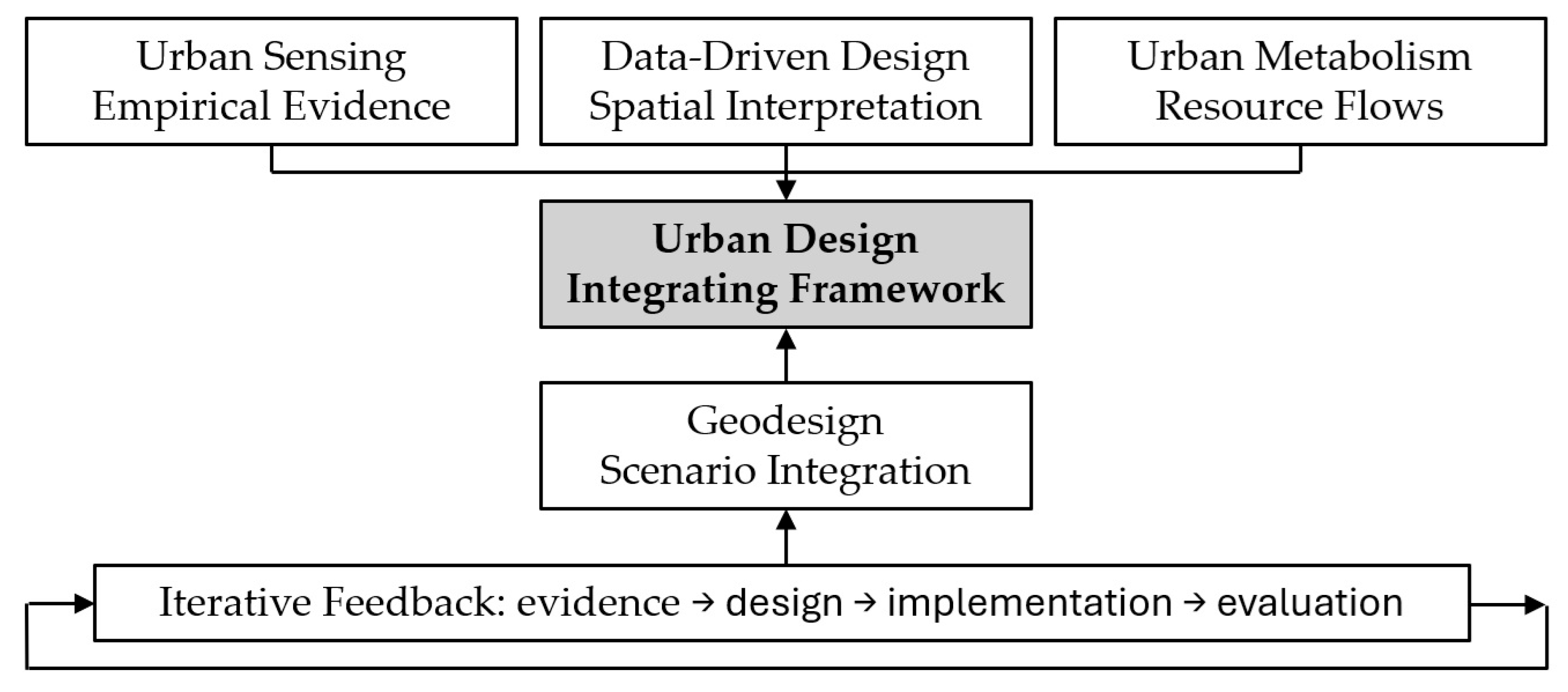
Together, these four analytical models clarify different but complementary positions in the urban-design process: sensing establishes an evidence base; performance-oriented analysis interprets that evidence against explicit goals; urban metabolism reveals resource flows and systemic dependencies; and geodesign converts spatial evidence into iterative scenarios for evaluation and decision. They should therefore be read as functional roles rather than competing theories. Their shared contribution is to replace a linear conception of planning and design with an iterative process in which evidence, design, implementation, and evaluation continuously inform one another. The principal risk is that increasingly sophisticated models may be mistaken for neutral or complete representations of urban life. They remain selective constructions and must be interpreted through professional, political, civic, and local knowledge. This relationship is summarized in
Figure 1.
5. Stage III—Computational Design Support: Artificial Intelligence-Aided Urban Design
Artificial Intelligence-Aided Design (AIAD) is used here as an umbrella term encompassing AI-assisted, AI-supported, and AI-enabled design methodologies. AIAD extends computation beyond drafting and visualization towards pattern recognition, prediction, generation, optimization, and performance evaluation. Recent generative urban-design research increasingly combines generative models with explicit spatial constraints, performance criteria, and human review rather than treating AI as an autonomous designer [
36,
37]. This distinction is important: AIAD is understood here as augmentation of the analytical and exploratory capacities available to urban design, while designers and planning actors retain responsibility for problem framing, contextual interpretation, and final spatial decisions [
38,
39,
40,
41].
A typical AIAD workflow includes four connected stages: data acquisition, pattern recognition, generative modelling, and performance evaluation. Data may derive from GIS, BIM, remote sensing, environmental sensors, mobility traces, demographic databases, and public consultation. Machine-learning methods identify relationships or predict outcomes. Generative systems then create alternatives, while evaluation modules compare them against criteria such as solar access, energy demand, accessibility, density, ventilation, walkability, public-space provision, and environmental exposure.
Applied work demonstrates how this workflow can move beyond conceptual description. A 2023 generative-design methodology automated plot subdivision and housing-type allocation while retaining interaction between planner and software [
36]. More recent generative approaches use diffusion models or generative adversarial networks to produce urban layouts under land-use, network, environmental, or morphological constraints [
37,
42]. These cases illustrate both the value and the limit of AIAD: it can accelerate option generation and reveal design possibilities, but generated alternatives still require evaluation for feasibility, context, public value, and unintended effects.
Recent scholarship also brings generative AI into direct dialogue with urban digital twins. A 2024 scoping review identifies applications in generating urban data, scenarios, designs, and 3D city models, while stressing data quality, scalability, validation, and integration challenges [
43]. Emerging 2025 work on generative spatial AI further demonstrates the potential to model and predict complex urban flows within digital-twin environments [
44]. These developments strengthen the design-exploration capacity described here, but they also reinforce the need for explainability, uncertainty reporting, human oversight, and evaluation against explicit urban-design and sustainability criteria.
Genetic algorithms illustrate this process particularly clearly. A population of alternative urban forms is generated; design parameters such as height, density, setback, orientation, green-space allocation, or land-use distribution are encoded; each alternative is evaluated against a fitness function; better-performing alternatives are selected and recombined; mutation introduces variation; and the process continues until a threshold or convergence condition is reached [
45,
46,
47,
48]. Recent applications demonstrate the continuing relevance of the method at urban scale. In central Tianjin, a genetic-algorithm model optimized the location of multi-scale green spaces against multiple microenvironmental benefits and linked the results to land-use planning [
46]. In Dubai Silicon Oasis, genetic optimization was used to compare district and block morphologies against solar-radiation and floor-area objectives [
47]. A Greater London application coupled genetic algorithms with Pareto optimization to test future development patterns against heat, flood, brownfield, mobility, and growth objectives, explicitly revealing conflicts among sustainability goals [
48]. These applications show why evolutionary methods are useful not because they identify a single ‘best’ city form, but because they expose feasible alternatives and trade-offs within a large solution space.
For urban design, however, optimization is never purely technical. The definition of the fitness function determines what the system values. A model optimized only for energy or development capacity may reduce public-space quality, heritage continuity, affordability, or social diversity. AIAD therefore requires multi-objective evaluation and human oversight. The designer remains responsible for translating computational outcomes into context-sensitive spatial decisions and for ensuring that qualitative values are not excluded merely because they are difficult to quantify [
30,
31,
41]. The resulting iterative relationship between computational support and human oversight is illustrated in
Figure 2.
AI can also strengthen participatory planning through natural-language processing, visualization, scenario interfaces, and analysis of consultation material. Emerging work with large language models and generative systems suggests potential for stakeholder communication, scenario exploration, and participatory planning support, while also raising questions about authenticity, representativeness, trust, and the danger of substituting synthetic participation for actual civic influence [
49]. Human-centered AI therefore requires transparency about data and model limitations, contestability of outputs, clear accountability, and explicit responsibility for final decisions [
30,
31,
41]. Explainability is particularly important when model outputs influence public choices: an apparently persuasive generated proposal should not obscure uncertainty, embedded assumptions, or the value judgements encoded in prompts, training data, objectives, and evaluation criteria.
6. Stage III—Computational Design Support: Parametric and Agent-Based Methods
Parametric urbanism extends algorithmic thinking from individual buildings to complex urban environments. Rather than defining a fixed form, a parametric model defines relationships among variables such as building height, density, street width, plot configuration, land use, solar exposure, wind, landscape, and mobility. When one parameter changes, connected elements are recalculated, allowing designers to explore families of spatial alternatives while maintaining systemic coherence [
40,
50,
51,
52]. Related work on the urban integration of active solar systems likewise shows that siting and building massing need to be treated as coordinated design variables rather than as technical additions applied after urban form has been fixed [
53].
Its value for sustainable urban transitions lies less in formal novelty than in the capacity to incorporate environmental intelligence during design. Solar radiation, shade, ventilation, heat exposure, vegetation, water management, accessibility, and walking distance can become active parameters. This transforms environmental evaluation from a retrospective check into a generative influence on urban morphology. Parametric tools are especially useful where multiple objectives must be negotiated rather than maximized independently.
A useful applied example is the Tianjin urban-greening study noted above, where environmental indicators and genetic optimization were combined to locate new green spaces across a dense built environment [
46]. At a different scale, the Dubai Silicon Oasis study linked GIS-derived geometry, Grasshopper-based parametric modelling, environmental simulation, and genetic optimization to compare district street patterns and urban blocks [
47]. Such cases make clear that parametric urbanism is most defensible when parameters correspond to explicit spatial and environmental questions rather than becoming an end in themselves. More recent parametric research comparing contrasting European climates similarly links urban morphology, renewable-energy integration, and outdoor thermal comfort as interdependent design variables [
54].
Swarm intelligence adds a decentralized and adaptive logic. Inspired by the collective behavior of ants, birds, bees, and fish, swarm algorithms use simple local rules among multiple agents to generate emergent global patterns [
55,
56,
57]. Urban applications include transport routing, pedestrian and crowd simulation, evacuation, energy distribution, waste collection, ecological connectivity, and land-use allocation. Such models are suited to urban conditions because movement and use patterns emerge from many interacting actors rather than from a single central command.
Pedestrian simulation is particularly relevant to urban design. The foundational social-force model remains influential [
58], but contemporary research has extended pedestrian modelling through empirically informed and large-scale agent-based approaches. A 2023 Salzburg case simulated highly disaggregated pedestrian flows at city-region scale, including activity, route, destination, timing, and walkability-sensitive route choice, and tested uncertainty against observed pedestrian counts [
59]. Other recent models explicitly address high-density pedestrian dynamics and parameter sensitivity [
60,
61]. These methods can reveal crowding, route choice, bottlenecks, and the effects of spatial interventions on collective movement, improving the design of stations, squares, streets, and emergency routes. Yet simulated agents remain abstractions: cultural practices, perception, disability, age, informal use, and unequal access cannot be reduced to universal behavioral rules, and uncertainty analysis should accompany claims about predictive performance.
Parametric and swarm-based methods should therefore be treated as design-support systems. Their strongest role is to expand the range of alternatives, expose relationships, and support iterative refinement. Urban quality still depends on professional judgement, public deliberation, cultural interpretation, and attention to lived experience. The relevant measure is not computational complexity, but whether the method helps produce accessible, climatically responsive, socially inclusive, and adaptable places.
7. Stage IV—Decision-Making and Spatial Intervention: Multi-Criteria Methods
7.1. The DEX Method and Symbolic Evaluation
Architectural and urban-design decisions combine measurable performance with qualitative judgements. The DEX method addresses this condition through hierarchical multi-attribute modelling using symbolic rather than exclusively numerical values. Criteria are organized in a decision tree and assessed through categories such as poor, acceptable, good, or excellent. This makes complex evaluations more legible to designers, juries, and stakeholders and supports explicit discussion of the rules by which alternatives are compared [
62].
Recent research has integrated DEX into CAD environments such as Rhinoceros and Grasshopper and applied it to architectural and urban-design competitions, including the Polje III residential case in Ljubljana [
62]. Qualities such as spatial organization, housing quality, sustainability, and technological integration can be structured as attributes and linked to design alternatives. The method is valuable because it does not pretend that every urban quality can be expressed with false numerical precision.
The key urban-design contribution is the translation of subjective and experiential values into an auditable decision structure. Sense of place, identity, aesthetic coherence, and social usability remain open to interpretation, but the criteria and aggregation rules can be made visible. This strengthens transparency without eliminating professional judgement.
7.2. AHP, ANP, and the B.O.C.R. Framework
The Analytic Hierarchy Process (AHP) and Analytic Network Process (ANP) provide structured methods for ranking alternatives under multiple criteria [
63,
64]. AHP organizes goals, criteria, sub-criteria, and alternatives hierarchically; ANP allows feedback and interdependence among criteria. The B.O.C.R. framework—Benefits, Opportunities, Costs, and Risks—broadens evaluation by considering positive and negative, present and future implications.
For urban transformation, these methods can compare development, regeneration, climate-adaptation, infrastructure, and neighborhood strategies by making criteria and weights explicit. Applied studies demonstrate their practical role. In Istanbul, AHP and ANP were combined within a multi-tiered framework for flood hazard, vulnerability, and risk assessment, with stakeholder focus groups contributing to framework refinement [
65]. AHP has also been used to prioritize sustainability criteria for neighborhood assessment through structured expert consensus [
66]. These examples are more representative of the method’s urban-design relevance than hypothetical city-model rankings: they show how multi-criteria analysis can organize competing environmental, spatial, social, and institutional considerations before intervention.
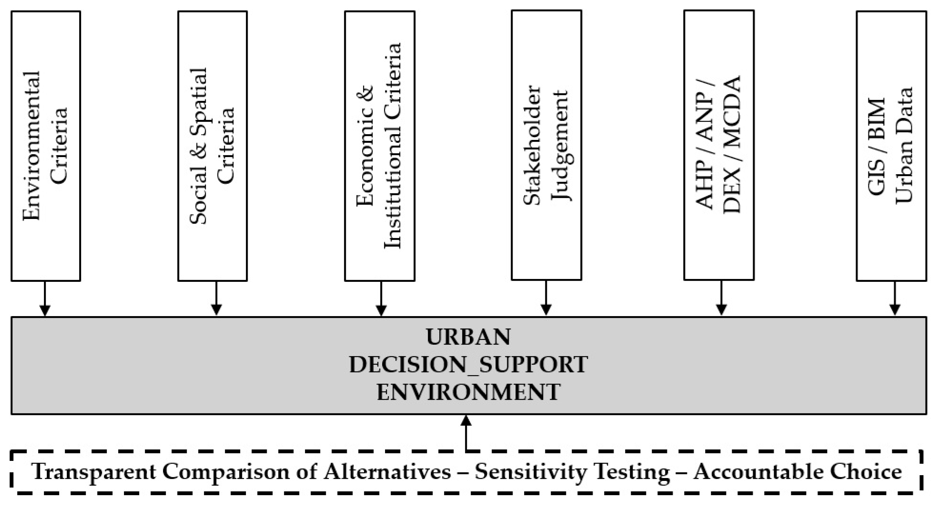
Figure 3 synthesizes these elements as an integrated urban decision-support environment.
DEX and AHP/ANP overlap in their purpose—making multi-criteria judgement explicit—but they are not interchangeable. DEX is especially useful where criteria are qualitative, categorical, and naturally expressed through decision rules, for example when juries or stakeholders assess spatial quality, identity, usability, or design coherence [
62]. AHP is preferable when a hierarchical problem can be represented through pairwise comparisons and numerical priority weights, while ANP is useful when dependencies and feedback among criteria must be represented [
63,
64,
65,
66]. The approaches can also be combined sequentially: AHP/ANP can help establish or test relative criterion importance, while DEX can structure qualitative aggregation and communicate rule-based evaluations. In all cases, criteria selection, weighting, rule construction, and stakeholder representation influence outcomes. Robust application therefore requires sensitivity testing where appropriate, transparent documentation, and participation by groups affected by the decision. Multi-criteria methods are most useful when they organize deliberation rather than merely generate a final score.
8. Stage IV—Decision-Making and Spatial Intervention: Ecological Objectives and Design Integration
Sustainable urban transitions require a shift from treating nature as residual open space towards integrating ecological processes into streets, buildings, landscapes, and infrastructure. Reconciliation ecology proposes that biodiversity can be supported within human-dominated environments through deliberate habitat creation and adaptation [
67]. Within this review, reconciliation ecology is therefore not treated as a technology equivalent to AI, sensing, or digital twins. It is an ecological design objective and evaluative lens that those technologies can help operationalize. This distinction strengthens the process logic of the review: technological systems provide evidence and analytical capacity, design and decision-support methods translate evidence into spatial alternatives, and ecological criteria help determine whether those alternatives improve coexistence, resilience, and ecosystem function.
The DeMo framework develops this principle across landscape, urban, and building scales. It combines ecological analysis, GIS, BIM, parametric design, simulation, collaborative data environments, and extended-reality visualization to support the integration of habitats in constructed ecosystems [
68,
69]. It is presented here as an emerging applied example rather than a widely validated assessment framework. Its principal relevance is methodological: ecological evidence is introduced during design development, allowing habitat continuity, vegetation, water, species requirements, and spatial configuration to influence decisions before urban and architectural choices become fixed. Because the published application base remains limited, however, its transferability and long-term biodiversity outcomes require further empirical testing.
Life-hosting buildings exemplify this approach. Building envelopes, roofs, courtyards, and adjacent public spaces can support nesting, vegetation, pollinators, water retention, cooling, and habitat connectivity. At the urban scale, green-blue corridors, street trees, permeable surfaces, and connected open spaces can reduce heat and flood risk while improving public health and everyday experience [
70,
71,
72,
73]. Digital tools support this work by mapping habitat networks, predicting environmental conditions, comparing scenarios, and monitoring performance over time.
The urban-design significance of reconciliation ecology is therefore spatial and experiential as well as biological. Ecological infrastructure influences shade, comfort, walkability, identity, stormwater performance, and the character of public space. This places DeMo alongside, rather than above, established green-infrastructure and nature-based-solution approaches that similarly connect multifunctionality, ecosystem services, climate adaptation, human well-being, and biodiversity [
70,
71,
72,
73]. Technology is valuable when it helps designers understand these relationships, compare alternatives, and monitor outcomes; it does not substitute for ecological objectives, local knowledge, governance, maintenance, or long-term stewardship.
9. Stage V—Outcome Evaluation and Feedback: ISUQ in Comparative Perspective
Outcome evaluation requires evidence about whether technology-supported interventions improve urban conditions rather than merely increase technical capability. ISUQ, developed by Garau and Pavan and tested in two Cagliari neighborhoods, is retained as one context-specific example because it combines objective and subjective neighborhood indicators [
74]. It is not treated as the culminating framework of the review or as a universally validated standard; its role is illustrative and is interpreted alongside established neighborhood sustainability assessment systems.
ISUQ groups indicators under use and fruition, health and well-being, appearance, management, environment, and security. These dimensions cover accessibility, services, green space, pollution, landscape and housing quality, maintenance, waste, heritage, water, recycling, lighting, crime prevention, and social security. Their value here is to demonstrate the breadth of outcome evidence that may be required after a spatial intervention; they are not presented as six dimensions generated by urban design itself.
Garau and Pavan applied ISUQ to Villanova and Sant’Elia in Cagliari. Villanova, a central neighborhood affected by regeneration and pedestrian improvements, performed more strongly, whereas Sant’Elia revealed deficiencies concerning green areas, waste infrastructure, social integration, and justice; both neighborhoods showed accessibility problems for people with disabilities [
74]. This application is useful precisely because it demonstrates the framework at the scale and context in which it was tested. It should not be interpreted as evidence of universal validation, but as an example of how composite assessment can identify spatially specific priorities that citywide technological indicators may overlook.
ISUQ should also be read alongside established neighborhood sustainability assessment tools rather than in isolation. LEED for Neighborhood Development, BREEAM Communities, CASBEE for Urban Development, and related systems provide structured sustainability benchmarks, but comparative reviews show substantial variation in indicator coverage, weighting, geographical assumptions, and treatment of social, cultural, economic, and governance dimensions [
75,
76,
77,
78]. ISUQ has a much narrower empirical base, yet it is useful here because it foregrounds use, well-being, appearance, management, security, accessibility, and perceived public-space quality. The comparison in
Table 2 reinforces a central finding of this review: no single rating or indicator system can determine whether a technology-enabled intervention constitutes a sustainable urban transition. Evaluation requires multiple forms of evidence, attention to distributional effects, and context-sensitive professional and civic judgement.
Taken together, Stages I–V establish a functional chain from evidence and representation to analysis, design support, decision, spatial intervention, and outcome evaluation.
Table 3 compares the reviewed approaches on common dimensions rather than merely mapping objectives to sections. The comparison shows that established and emerging approaches differ substantially in data requirements, spatial scale, implementation maturity, and risk profile. Digital twins and generative AI remain comparatively immature in operational urban-design integration; sensing, geodesign, parametric methods, multi-criteria decision methods, and urban metabolism have longer application histories but remain constrained by data, modelling assumptions, and institutional context; ecological and neighborhood assessment frameworks primarily evaluate objectives and outcomes rather than generate designs. This functional differentiation is the evidential basis for the paper’s claim that no single technology or method can mediate sustainable transition on its own.
10. Challenges and Ethical Considerations
The capabilities reviewed above are accompanied by risks that are social, spatial, institutional, and technical. The digital divide can exclude low-income households, older people, migrants, and communities with limited connectivity or digital literacy; automated services may therefore reproduce unequal access unless non-digital alternatives and inclusive interfaces are maintained [
8,
29]. Smart-city development can also produce placelessness when generic technological solutions override local morphology, cultural practices, and the differentiated needs of neighborhoods. These concerns establish an important boundary condition for the review: technological sophistication is not equivalent to sustainable transition.
Privacy and surveillance are fundamental concerns because pervasive sensing systems collect detailed information about movement, behavior, consumption, and social interaction. Data governance must specify purpose, ownership, retention, access, accountability, and the right to challenge automated decisions. Cybersecurity is equally important because interconnected infrastructure creates new vulnerabilities across energy, mobility, water, and public services [
29,
30,
31].
Algorithmic systems may reproduce historical bias or privilege what can be easily measured. Decisions concerning training data, optimization criteria, thresholds, model architecture, and acceptable uncertainty are themselves normative choices. Transparency must therefore extend beyond software explainability to the institutional process through which a model is commissioned, selected, interpreted, contested, and acted upon. Urban designers, planners, architects, public agencies, elected authorities, infrastructure providers, communities, and other stakeholders retain differentiated but real forms of agency. Technology can inform their decisions, but it cannot assume professional, political, or democratic responsibility for them [
30,
31,
79].
There is also a risk of reviving the city-as-machine ideal: a top-down system presumed to become controllable through sufficient information. Contemporary systems and transition perspectives instead describe cities as open, adaptive, path-dependent, multi-scalar, and politically contested systems in which technological change interacts with institutions, infrastructures, practices, ecological processes, and power relations [
2,
4,
27,
80,
81,
82]. Bottom-up knowledge, local improvisation, civic participation, and governance learning are therefore constitutive elements of urban resilience, legitimacy, and transformative capacity rather than noise to be eliminated from an optimized model.
Finally, implementation capacity varies greatly between cities. Interoperability, procurement, financing, skills, maintenance, long-term data stewardship, institutional coordination, and the capacity to learn from experimentation often determine whether a pilot becomes durable urban infrastructure. Sustainable urban transition should consequently be understood as a long-term process of socio-technical and spatial change rather than a sequence of isolated technological demonstrations. Recent transition-governance research similarly emphasizes coordination, co-creation, institutional anchoring, adaptive governance, and reflexive learning as conditions for moving from experiments to enduring transformation [
80,
81,
82,
83].
11. Discussion: Urban Design as a Mediating Spatial Practice
Across the reviewed fields, a consistent functional sequence emerges, but the comparison also reveals important asymmetries (
Table 3). Sensing and computer vision are strongest at observation but weak at normative choice; digital twins integrate representations and simulations but remain constrained by interoperability and institutional maturity; generative and parametric methods expand alternatives but encode objectives and assumptions; multi-criteria methods expose trade-offs but depend on criteria, weights, and stakeholder representation; ecological approaches define non-human and resilience objectives; and neighborhood assessment frameworks evaluate outcomes after or alongside intervention. The evidence therefore supports a relational rather than hierarchical conclusion: these approaches are complementary because they answer different questions and fail in different ways.
Urban design is best understood here as one mediating spatial practice within this chain, not as an overarching framework that subsumes planning, governance, geodesign, or socio-technical transition processes. Its distinctive contribution is that strategic objectives, technical evidence, institutional choices, and lived experience become spatially testable in configurations of streets, plots, blocks, buildings, landscapes, mobility networks, and public spaces. The comparative evidence in
Table 3 supports this narrower claim: methods positioned upstream supply observations, models, alternatives, or decision structures, while outcome frameworks positioned downstream evaluate consequences; urban design is one arena in which these inputs are translated into spatial propositions and iteratively revised. Whether that mediation succeeds depends on planning authority, governance capacity, public deliberation, ecological knowledge, implementation resources, and post-intervention feedback. This mediating role also remains grounded in established urban-design concerns with street life, legibility, human scale, public-space quality, and the reconnection of fragmented urban districts [
84,
85,
86,
87].
This comparison suggests four forms of intelligence that need to remain connected. Digital intelligence provides sensing, integration, prediction, and simulation. Systemic intelligence identifies feedback, interdependency, thresholds, uncertainty, and unintended effects. Ecological intelligence situates intervention within climate, water, energy, material, and biodiversity systems. Civic and design intelligence brings contextual judgement, cultural meaning, spatial imagination, public deliberation, and knowledge of everyday use. The review’s specific contribution is to place these forms of intelligence within one spatial decision chain rather than treating them as independent attributes of a ‘smart’ city. Sustainable transition becomes plausible when evidence informs accountable choices, choices become spatial interventions, and interventions are evaluated against environmental and social outcomes. Eastern Mediterranean streetscape research further demonstrates how morphology, orientation, topography, solar exposure, and sky-view conditions can be combined to derive climate-responsive urban-design knowledge [
88].
The synthesis also clarifies the limits and boundary conditions of technologically assisted urban design. Urban problems contain plural values that cannot be reduced to a single objective function: efficiency, equity, identity, resilience, beauty, affordability, ecological performance, heritage, and accessibility may conflict. Model outputs are constrained by data quality, scale, assumptions, uncertainty, institutional capacity, and the participation of affected groups. Methods successful in data-rich metropolitan settings may not transfer directly to smaller, resource-constrained, historically complex, or informally developed contexts. The appropriate role of emerging technology is therefore to reveal relationships, make assumptions and trade-offs more explicit, expand the range of alternatives that can be explored, and support accountable choice—not to determine the desired urban future. The same principle is evident at the building/housing scale, where prefabrication, environmental systems, energy performance, daylighting, and cost must be considered together rather than optimized independently [
89].
The review also has limitations. As a critical narrative review, it synthesizes heterogeneous theoretical, methodological, and applied studies rather than providing a statistically exhaustive or bibliometric account. The breadth necessary to connect smart-city systems, AI, systems science, decision support, ecological design, and urban-quality evaluation also limits the depth with which individual technologies can be examined. Rapid development in generative AI, digital twins, computer vision, and urban analytics means that the evidence base will continue to change quickly. The framework advanced here should therefore be treated as an interpretive synthesis to be tested through comparative applications, longitudinal evaluation, and research across different governance, climatic, cultural, and resource contexts.
12. Conclusions and Implications for Sustainable Urban Transitions
This review asked how newly emerging digital capabilities and established computational and decision-support methods, when applied in novel or rapidly evolving ways, can support accountable urban-design decisions for sustainable urban transitions. The comparison shows that the answer depends less on whether a method is labelled “emerging” than on its functional role, evidence requirements, scale, implementation maturity, and limitations. Emerging capabilities such as generative AI and operational urban digital twins extend scenario generation, integration, and prediction, while established methods such as GIS, geodesign, parametric modelling, genetic algorithms, AHP/ANP, and agent-based simulation remain important through new combinations, data environments, and urban applications.
The principal finding is that technological capability does not in itself constitute sustainable urban transition. Its value depends on how evidence is interpreted, how competing objectives are negotiated, how decisions are translated into urban form, and whether resulting places improve resilience, ecological performance, accessibility, inclusion, well-being, and quality of life.
The paper’s contribution is a functionally organized comparative synthesis rather than a claim that urban design governs sustainable transitions. Urban design is positioned more narrowly as a mediating spatial practice within wider planning, governance, socio-technical, and socio-ecological processes. Its value lies in making evidence, objectives, trade-offs, and consequences spatially explicit and therefore open to professional, civic, ecological, and institutional evaluation.
For practice, emerging technologies should be deployed as transparent and contestable decision-support instruments within iterative design processes. For policy and governance, investment in digital capability should be accompanied by institutional capacity, ethical data governance, interoperability, accessibility, public participation, long-term stewardship, and mechanisms for learning from implementation.
Future research should test the proposed synthesis through comparative and longitudinal cases and should examine more closely how digital twins and generative AI influence actual design decisions; how uncertainty and qualitative place values can be represented without being displaced; how benefits and risks are distributed among neighborhoods and social groups; and how biodiversity, microclimate, circular resource flows, resilience, and citizen co-design can be evaluated together.
Emerging technologies should therefore be understood as enabling instruments rather than objectives of urban development. Their contribution to sustainable urban transitions ultimately depends on whether they help human actors create and adapt places that are environmentally responsible, resilient, inclusive, accessible, livable, and responsive to local context.