1. Introduction
The World Health Organization establishes that the minimum threshold for an urban green space should not fall below 9 m
2 per inhabitant. In contrast, the literature consistently ranks Athens among the European capitals with the lowest green space availability per resident, highlighting a critical deficiency in green infrastructure across major Greek cities [
1]. This spatial deficit directly conflicts with the United Nations 2030 Agenda and its 17 Sustainable Development Goals (SDGs). Among these, SDG 11 explicitly targets the transformation of cities and human settlements to make them inclusive, safe, resilient, and sustainable [
2].
Pocket parks are small urban green spaces, whose main characteristics are their size, location, functions, users, and, finally, their ecological impact on the urban area [
3]. Pocket parks may help address the lack of large spaces for land preservation, as well as the need for green spaces at the neighborhood scale. They constitute important forms of urban open space at the micro scale, often described using terms such as pocket parks, parkettes, mini-parks, vest-pocket parks, or vesty parks. They occupy an area of 1–3 plots and usually do not exceed 1000 m
2. Their area is determined by land availability rather than by area requirements for green spaces. When strategically dispersed throughout the dense urban fabric, pocket parks operate as a decentralized network of micro-scale green infrastructure that directly benefits the local population [
4].
In terms of urban planning, pocket parks represent a distinct category of urban green space and outdoor recreation space positioned between a neighborhood park and a private garden [
3]. These small parks tend to function like neighborhood parks, and often try to serve a variety of needs [
5]. Pocket parks can serve multiple functions, including small event spaces, children’s play areas, relaxation or gathering zones for residents and visitors, and seating areas for dining or leisure. They act as small urban refuges, providing relief from the surrounding city bustle and opportunities for rest and social interaction [
6].
However, the limited size of pocket parks and the varying needs of users—which can also fluctuate over the course of the day—pose challenges for their design and functionality. Thus, the design of a pocket park must take into account the needs of all population groups within the surrounding area. The primary design goal is to create a socially oriented space. The primary design goal is to create a socially oriented space. The layout is programmed to accommodate a broad spectrum of neighborhood uses—ranging from active community events to passive, tranquil relaxation. By prioritizing flexible zoning and universal access, the park is explicitly designed to support activities from diverse cultural backgrounds, fostering intercultural dialogue and social equity [
7].
Moreover, due to their size, these green spaces are organized in such a way that the arrangement of spatial elements tends to produce simple rather than complex forms, both in terms of communication and functionality [
8]. In addition, pocket parks can transform abandoned and unused urban spaces into areas of urban regeneration, as they are often created on vacant lots and forgotten leftover spaces [
9,
10]. Many pocket parks are the result of community groups, private entities, or foundations reclaiming these spaces for the benefit of the local community and fostering community interaction [
11]. Pocket parks are often easier to create than to maintain, due to a lack of functional planning, community support, and use, and they are likely to decline as a result. Common issues in pocket park maintenance include aging infrastructure, weather and environmental factors, vandalism and theft, visitor access, and staffing shortages [
12]. The attributes defining the physical design of pocket parks have been investigated in [
13], where authors underlined the maintenance quality as the most statistically significant variable: highly accessible and expensively constructed pocket parks may lose their public image when neglected.
From 1964 to 2010, the evolution of pocket parks occurred primarily through an uncoordinated trajectory, resulting in a sporadic distribution across the urban fabric. They typically emerged in specific, localized areas that held immediate community value within dense metropolises suffering from a critical deficit of public green infrastructure [
14].
Despite the growing body of literature on pocket parks and their multidimensional benefits, a significant gap remains: existing studies either assess the sustainability performance of small green spaces qualitatively or develop parametric tools for spatial design, but rarely integrate the two within a unified framework. To date, no study has systematically linked an SDG-based multi-criteria evaluation of pocket park benefits to a reproducible parametric design routine capable of guaranteeing the spatial conditions that generate those benefits on any available urban plot.
This paper addresses that methodological gap through two structurally interrelated outputs. First, it develops a multi-criteria evaluation tool that maps the environmental, social, and economic benefits of pocket parks onto the relevant UN Sustainable Development Goals (SDGs), thereby enabling a structured qualitative assessment of existing and proposed spaces. Second, it translates the spatial design parameters derived from this evaluation into a parametric design routine implemented via Grasshopper, formalizing the topological relationships among those parameters into an explicit geometric logic adaptable to any plot configuration. The evaluation tool thus informs the parametric model: the SDG-relevant spatial characteristics identified in the assessment phase become the constraints and objectives encoded in the algorithmic design sequence.
The study pursues three specific objectives:
O1: To identify and categorize the spatial, social, and environmental design parameters of pocket parks in relation to the three pillars of sustainability and the relevant SDG sub-targets.
O2: To develop and apply an SDG-aligned multi-criteria evaluation tool and subsequently test it on four case studies, assessing the degree to which each park satisfies the identified sustainability criteria.
O3: To firstly identify and then translate the spatial design parameters into a reproducible parametric routine (Grasshopper) and validate its adaptability across five diverse urban plot configurations.
The paper is structured as follows:
Section 2 presents the methodology and case study selection.
Section 3 analyzes the environmental, social, and economic benefits of pocket parks and their alignment with the SDGs, leading to the development of the multi-criteria tool. The spatial design parameters are also explained in
Section 3.
Section 4 discusses the results of the multicriteria application tool, the parametric design methodology, and its application.
Section 5 draws conclusions and outlines directions for future research.
2. Materials and Methods
2.1. Methodological Outline and Research Questions
The methodology is outlined in
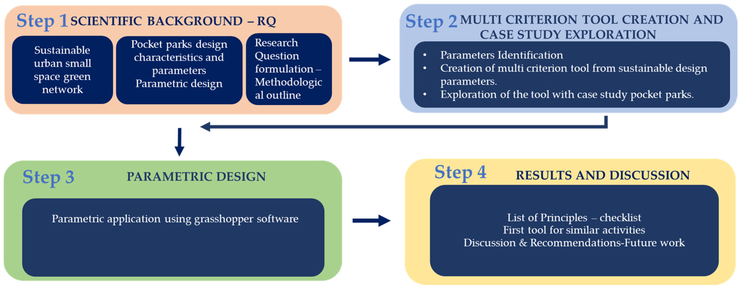
Figure 1. Step 1 includes the scientific background in the fields of urban green network and the use of small urban spaces, parameters of sustainable development related to the design of pocket parks, and parametric design. The design is created using Rhinoceros 3D (version 8) (Robert McNeel & Associates, Seattle, WA, USA) and its visual programming plug-in Grasshopper (developed by David Rutten at Robert McNeel & Associates), which together permit the integration of parametric design applications within a single modeling environment. The ownership of the software belongs to one of the authors, namely Nikos Kourniatis. The software environment enables the visualization of the different functions and their parameters, which are combined to construct a network of interconnections that depict the structure of the parameters.
Step 1 also includes the formulation of the research questions addressed, as well as the presentation of the methodological outline. Step 2 focuses on the identification of the sustainable design parameters related to the research questions, the formulation of methodology, and the creation of the multicriteria tool. In this step, the tool is tested by implementing it in the case study of pocket parks. Step 3 focuses on the parametrization of the former results in the Grasshopper software (version 8). Finally, Step 4 includes the results and discussion regarding the research questions identified.
In line with the SDGs, and given the lack of urban green spaces and infrastructure networks in densely populated cities, this study examines pocket parks as micro-scale urban green spaces that can be parameterized and adapted to fit any available site within the urban fabric, regardless of neighborhood context. This research primarily seeks to assess pocket parks regarding their benefits to local communities, their role in enhancing urban green spaces, and the parameters required for their implementation in any vacant urban site.
The research questions formulated in this study can be summarized as follows:
RQ1: What characteristics do pocket parks have according to the three major pillars of sustainability? The question characterizes pocket parks across the environmental, social, and economic pillars of sustainability through a literature synthesis. This establishes the conceptual foundation for everything that follows.
RQ2: Can connections between the spatial design characteristics of pocket parks be identified and rendered in space through software to parameterize them? The question bridges theory and digital representation, aiming to identify how those sustainability characteristics that manifest as spatial relationships can then be translated into parametric software logic.
RQ3: Can a sequence of commands be created that, when applied to any plot, ensures that all necessary spatial characteristics are incorporated? Question 3 is the applied output of the research—taking those parametric relationships and formalizing them into a replicable command sequence that can be executed on any urban plot, regardless of its specific geometry or context.
2.2. Case Studies
The pocket park typology is firmly established within contemporary urban design and spatial planning literature [
15]. Pocket parks emerged as part of post-World War II urban reconstruction efforts in Europe and in North America during the 60s [
16,
17]. Small parks were created to provide municipalities affected by the war with a means of rebuilding public space [
18]. This study examines four pocket park case studies, drawn from diverse international contexts: two from Greece, one from the United Kingdom (UK), and one from the United States of America (USA). These sites represent distinct developmental typologies and were selected primarily due to the heterogeneity and divergence of their spatial, environmental, and operational attributes. This baseline diversity facilitated a comprehensive exploration of divergent operational approaches, execution practices, and spatial design strategies, thereby establishing a broader comparative framework. (
Figure 2).
A prominent international example from the United States is the John F. Collins Park in Philadelphia [
19]. Occupying a compact spatial footprint of 360 m
2, the park represents a compelling manifestation of a privately owned public space (POPS) [
20]. The project was initiated by the City of Philadelphia, initially funded through the William Penn Foundation. Today, the park is managed and maintained by the Center City District Foundation, functioning within a specialized public–private partnership framework. In 1978, the William Penn Foundation purchased the plot, a former parking lot, and fully funded the park’s initial construction [
21]. The park was designed by landscape architect John F. Collins of The Delta Group. It is defined by ivy-covered green walls, and the whole park is shaded by a variety of native trees. A prominent waterfall fountain is centrally positioned within the park’s layout. The park has two iron gates that recall the private ownership of the public space and limited opening hours. One of the park’s most unique features is its furnishings, which include movable chairs and tables (
Figure 2a).
The Floating Pocket Park at Paddington, London, UK, occupies an area of 700 m
2 [
22]. The Floating Pocket Park in Paddington was developed as part of a privately led regeneration scheme in Paddington Basin in 2016, with public access secured through planning obligations [
22].
It consists of two decked platforms floating on a water basin and connected to the ground at two points. In particular, the first platform is covered with artificial turf and equipped with removable deckchairs and large, elongated beds with low plants. The second area is formed of hardscape floor and a pavilion bar with a canopy for visitors destined for private events. A separate small pontoon is designed to encourage wildlife such as birds and ducks. The defining characteristic of the Floating Pocket Park in Paddington lies in its unique construction as a floating green space, as shown in
Figure 2b, within a high-rise building commercial and residential district.
Within the Greek context, two case studies are cross-examined to evaluate different operational paradigms. First, Navarinou Park, situated in the high-density urban core of central Athens, serves as a prominent example of a self-managed, bottom-up community-led urban green space.
Pocket parks represent a distinct typology within contemporary urban governance and public administration: standard municipal parks versus community-managed open spaces (CMOS) [
23]. Self-managed socio-cultural spaces (SMPs) within the city of Rome occupied abandoned and neglected spaces, restricting disurbanity and fostering more inclusive urban futures [
24]. To demonstrate that self-managed pocket parks constitute an entirely distinct operational category, the case of Navarinou Park provides empirical clarity. Formerly a parking lot, it was transformed into a community park through the initiative of local residents in 2009 [
25]. The spatial layout of the park is organized into four distinct functional zones: a central gathering node anchored by a mature plane tree; a peripheral buffer area characterized by ornamental vegetation and informal, improvised seating elements; an activity zone containing an amphitheater and playground infrastructure; and an orchard featuring olive and citrus trees, interspersed with seasonal fruit and vegetable plants, as illustrated in
Figure 2c.
A regeneration initiative launched in 2020 by the Municipality of Athens promoted the creation of pocket parks on vacant urban plots. Implemented through the “Adopt Your City” program, the scheme assigns each site to a private company that undertakes the cost of rehabilitation and maintenance during the park’s initial adaptation phase [
26].
Researchers in [
27] demonstrated that the involvement of private actors does not necessarily lead to a private process, and at the same time, publicness benefits from private and public actors working in collaboration. The first park of this regeneration program has been created in the Kypseli area, which is the second Greek example of this research, and it is named The Butterfly Garden and was created in July 2020, with the financial support of the Deloitte Foundation [
28]. It consists of a flower garden integrating a significant number of representative species, as shown in
Figure 2d. The park is equipped with signs next to each plant containing useful information about its identity, as well as nesting structures and insect habitats to preserve local biodiversity.
Pocket parks contribute to the preservation of cultural values, including identity and authenticity, by functioning as public spaces that facilitate artistic expression and cultural representation [
29]. The selection of the different case study examples was based upon several criteria: first, the different spatial characteristics such as differentiations in scale and physiognomy that will be elaborated further in
Section 3.4 in
Table 3. For instance, the Butterfly Garden prioritized creating a specialized space that fosters urban biodiversity, whereas the Floating Pocket Park addresses localized recreational demands. Moreover, the dimension of governance was explored, leading to the identification of distinct institutional configurations across the investigated case studies. Funders, developers, and public authority roles are presented briefly in
Table 1. The four case studies were selected from a wider pool of examples because they represent clearly differentiated paradigms for pocket park development. They vary in terms of origin, design authorship, funding structures, and governance models, which makes them particularly suitable for comparative analysis. This variation allows the study to examine how pocket parks can emerge through contrasting processes—ranging from grassroots initiatives and municipal programs to philanthropic and private-led developments—while still performing similar urban and environmental roles.
2.3. Methodological Foundation for Spatial Evaluation of Pocket Parks
2.3.1. Environmental, Social, and Economic Benefits of Pocket Parks
As mentioned above, urban green spaces represent highly significant variables for the creation of a sustainable city. As an integral part of the urban fabric, urban open spaces and green areas have a significant impact on the quality of the urban environment and its inhabitants’ quality of life, while contributing greatly to the enhancement of the city’s image [
30]. The positive impact of small urban green spaces is evident in environmental, economic, and social terms. They enhance air quality, promote urban cooling and ventilation, and strengthen the connection between residents and the natural environment [
31,
32]. Additionally, they offer opportunities for recreation, rest, and social interaction, foster a sense of safety, and contribute to urban attractiveness by stimulating entrepreneurship and increasing property values [
33].
2.3.2. Environmental Benefits
An important benefit of urban, particularly mature tree canopies, is the substantial mitigation of atmospheric pollution in high-density urban fabrics. In particular, the improvement is achieved through air purification and oxygen production [
34]. Through the process of photosynthesis, urban tree canopies contribute to oxygen production and improved air quality [
35,
36].
Urban greenery, encompassing all forms such as linear tree alignments, isolated canopy specimens, and horizontal lawn strata, plays a pivotal role in the regulation of urban microclimates [
37]. By moderating temperature extremes—reducing excessive heat during summer and retaining warmth in winter—it contributes significantly to the mitigation of the urban heat island phenomenon. Urban green infrastructure functions as a critical mechanism for localized flood mitigation and sustainable stormwater management. Urban zones constructed adjacent to or directly above blocked streams face heightened vulnerability to severe pluvial flooding from overflowing manholes, causing costly damage to communities and citizens [
38]. In contrast, within areas integrated with urban greenery, a significant fraction of precipitating water is absorbed through canopy interception, while another portion infiltrates the soil profile, making it more fertile [
39]. Particularly in peri-urban environments or zones characterized by complex, high-gradient topographies, vegetative infrastructure plays a decisive role in slope stabilization and geomorphological risk mitigation.
Green spaces in urban areas can significantly reduce noise pollution [
40]. The foliage acts as a sound-absorbing filter and insulates the park from motorways, factories, school yards, etc., reducing the noise levels in urban areas [
40]. Pocket parks thus function as effective acoustic buffer zones that shield users from high-intensity municipal noise while encouraging a range of social activities to take place despite their close proximity to dense urban activity [
41].
Furthermore, wind velocity is also regulated by the specific structural attributes of urban vegetation, including tree height, species classification, canopy geometry, and foliage density. The denser the vegetation, the more effective it is at reducing wind speed [
42].
Urban greenery acts as a filter for dust and particles of various pollutants. Due to the aforementioned reduction in wind speed caused by vegetation, airborne particles accumulate on leaves. This dust is washed away by the next rainfall [
34,
43].
Urban green spaces act as the ecological components of the urban environment. They provide shelter for many species of fauna, including birds, insects, and small mammals. At the same time, they help to maintain the flora of the area. They therefore provide an opportunity to improve and stabilize the urban ecosystem. They also enhance the city’s biodiversity by permeating it at the neighborhood level: the habitat they provide for insects and birds, two species important for pollination, ensures healthy, active green cores in dense urban neighborhoods [
44].
Neighborhood green spaces may reduce car dependency. Combined with wider sidewalks and bicycle lanes, they encourage walking and cycling while contributing to reduced urban traffic congestion [
45].
Therefore, urban greening contributes to the protection of environmental resources and the improvement of the microclimate, while maintaining the presence of nature inside the urban tissue [
46].
2.3.3. Social and Psychological Benefits
Urban green spaces provide city dwellers with places to rest, relax, contemplate, read, and play. They may also include areas equipped with sports facilities, spaces for collective gatherings, recreational and outdoor events, and often a blend of these functions with cultural activities [
5]. Furthermore, the compact scale of pocket parks promotes a sense of social familiarity among users [
47]. This sense of “familiarity” enables these spaces to serve as outdoor lounges that naturally encourage social interaction and community cohesion. The once empty spaces are transformed into multifunctional outdoor halls that welcome people of different cultures, ages, genders, and needs. They generate social challenges by bringing people together to create social activities, stimulating a whole process of urban regeneration.
Interpersonal relationships are developed through physical contact, exchange of views, experiences, and thoughts. They function as social spaces that help reduce feelings of loneliness [
48]. As part of this socialization, they also act as places for users to express themselves. Even the smallest parks provide a sense of place and are used for a wide range of social activities. They provide familiar spaces where people can meet friends, relax, play, and enjoy nature while expressing a sense of community [
48].
Vegetation in urban green spaces brings urban residents directly into contact with nature. The variability of nature also fosters an awareness of the changing seasons and other natural changes. Pocket parks provide an essential venue for localized social integration, enabling families and neighborhood networks to assemble casually following daily work and school routines. Young families and senior citizens can relax and socialize in a well-designed and lively public space.
Small neighborhood green spaces also act as critical safety shelters in emergency situations, particularly as seismic refuges during earthquakes. People in such situations need to seek refuge in open spaces, life-safety buffers, clear structural collapse envelopes, and falling building debris [
48,
49].
Research confirms that exposure to nature drastically reduces physiological and psychological stress levels, which are disproportionately high within urban populations. Open green spaces improve a person’s general well-being, whereas the absence of such spaces may contribute to feelings of deprivation. Natural open spaces are crucial for children’s early socialization, the development of their imagination, creativity, self-confidence, and ability to socialize [
3].
Furthermore, activities such as pocket-scale urban farming directly improve fresh food accessibility and dietary diversification within dense residential neighborhoods. This engages the local community in a culture of healthy eating and food production, creating a micro-sustainable community where people collaborate, relax, learn, and enjoy, all while producing food. This can encourage a future that has a more sustainable lifestyle in the neighborhood to collectively address climate change and food shortages [
50].
Pocket parks function as a powerful instrument for social inclusion and intergenerational cohesion, providing vital opportunities for immediate community interaction to social groups such as socially isolated individuals, marginalized youth, parents with young children, and older adults characterized by severely restricted mobility [
51]. They introduce crucial spatial equity into dense urban fabrics, offering an outdoor refuge for children who would otherwise lack access to natural green environments. Furthermore, unique therapeutic opportunities are provided to elderly residents by integrating micro-agriculture. Seniors facing physical limitations that prevent the maintenance of conventional, large-scale plots are instead allocated compact micro-allotments.
Pocket parks make use of empty spaces that have a physical identity but lack functional activity. They transform passive, inactive spaces into active ones by attracting users who, in turn, bring the area to life. They trigger social change by attracting people and activating user interest [
52].
Researchers in [
14] reframed the notion of pocket parks as a “social product” fostering casual daily encounters and local neighborhood ties. Another interesting study examined data collected from 74 pocket parks during weekdays and weekends, investigating the flexibility of their use, while fluctuating social activities [
53]. The authors conclude that mixed-use surroundings and boundary designs maximized the equal access of citizens from diverse socioeconomic groups. Authors in [
52] investigated park use and concluded that neighborhoods’ social environments are significantly related to park use, serving community and individual recreation purposes, relating therefore the environment of the local parks with the social community. Small-scale parks act as community hubs with social health benefits, encouraging intergenerational interaction and lowering social isolation [
51]. From the above-mentioned related literature, it can be concluded:
Pocket parks act as homes’ immediate extensions, due to their positioning inside the dense urban tissue [
14].
Their informal layout supports flexible uses by different micro-communities during weekdays [
14].
Their success is related to community trust and social access [
52].
2.3.4. Economic Benefits
Pocket parks are often tucked away in downtown commercial areas and dense residential areas near neighborhood shops, where visitors can shop, rest, or take a break from work while enjoying the quiet atmosphere and shade of the park. The existence of pocket parks and other small green spaces often leads to a rise in property values in the nearby properties. Properties located close to green areas tend to have higher rents and sale prices than those in less green neighborhoods, since access to nature improves residents’ well-being and enhances the perceived quality of life in the area [
54]. The increased movement of people into the area due to the green space brings commercial development, attracting businesses, investors, and tourists, therefore creating new attraction areas.
Urban green spaces contribute to energy savings by providing shade and reducing high temperatures, especially during the summer period. Certain forms of urban greenery may also support small-scale food production and other ecosystem services, all of which contribute to the economy and improve the lives of local people [
50].
Financial and operational constraints encountered during pocket park maintenance have been investigated in [
51]. The authors have proposed alternative management models, addressing the small size and scattered locations of pocket parks within the urban tissue, dispatching the centralized municipal management, while focusing on partnerships between the public and private sectors. A recent study addresses how maintenance neglect implies that the space is unsafe for specific demographic groups and stresses that active maintenance is required for transitioning from urban green to mental health [
55]. The author in [
56] investigated the design of pocket parks for establishing resilient micro-spaces with long maintenance needs. In this paper, maintenance guidelines are introduced in the design phase by installing resilient architectural elements, mitigating heavy traffic wear. In [
57], one hundred local greening initiatives in Europe have been analyzed for evaluating “citizen-led” initiatives as opposed to classic municipal frameworks, concluding that self-managed pocket parks emphasize social programming and localized self-resilience [
58].
In conclusion, the benefits of creating, protecting, and properly maintaining green spaces in the urban fabric are manifold. While public green infrastructure provides significant social and ecological benefits within high-density urban environments, its efficacy is entirely contingent upon rigorous design and sustained maintenance. Without deliberate planning and consistent operational upkeep, these micro-spaces can quickly degrade, giving rise to severe spatial and social dysfunctions [
59]. Fallen leaves can clog the grates of storm drains, preventing rainwater from entering the city’s drainage system, or tree pruning may cause problems if not carried out at the right time of year; overgrown foliage may obstruct road signs and cause accidents. However, the disadvantages of pocket parks are relatively few and can be mitigated when compared to the numerous positive benefits they provide to the urban environment, cities, and residents. Ultimately, pocket parks can contribute to the development of more sustainable and resilient urban communities—one that integrates sustainability and climate change considerations into daily life, aligning social environmental awareness with economic viability.
3. Results
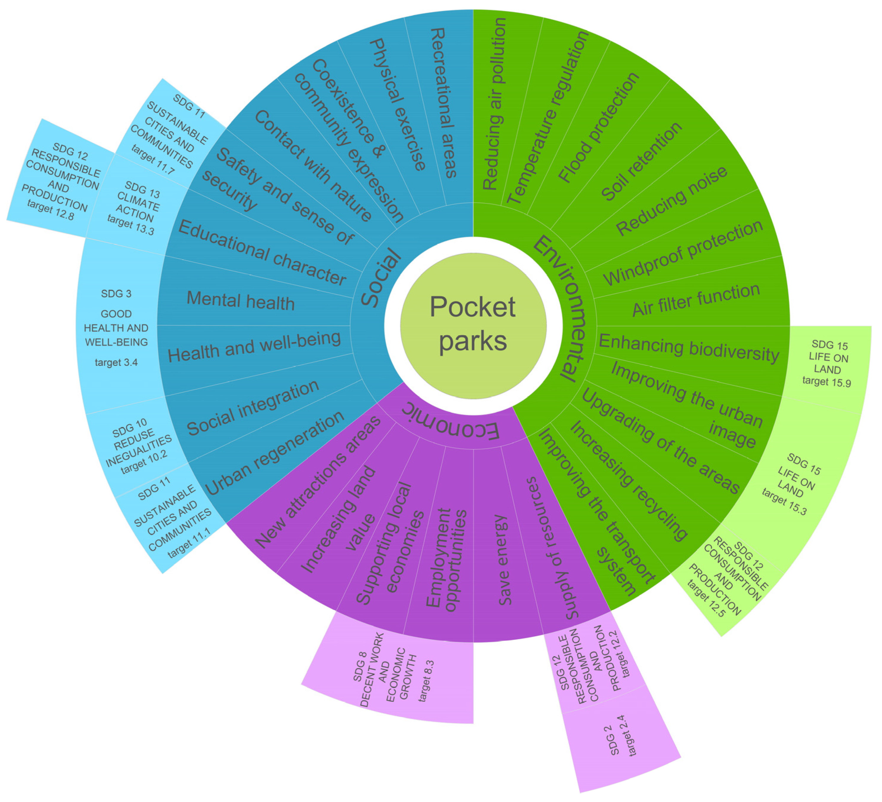
As evident from the description of these small green spaces—their characteristics and their capacity to be “embedded” within the urban fabric—pocket parks are being increasingly recognized as a potential first step toward sustainable urban regeneration and equitable access to public spaces in densely populated cities. Their environmental, economic, and social benefits respond to several Sustainable Development Goals, including SDG 11: sustainable cities and communities, defined as a starting point for research. Additionally, this work addresses SDG 2: zero hunger, SDG 3: good health and well-being, SDG 8: decent work and economic growth industry, SDG 10: reduced inequalities, SDG 12: responsible consumption and production, SDG 13: climate action, and SDG 15: life on land, respond to the financial crisis, food production pressure, underdeveloped communities and the lack of public space development. Through their environmental, social, and economic benefits, pocket parks contribute to the following sub-targets: 2.4, 3.4, 8.3, 10.2, 11.1, 11.7, 12.2, 12.5, 12.8, 13.3, 15.3, and 15.9 [
2].
3.1. Multi-Criteria Tool Based on SDG Principles
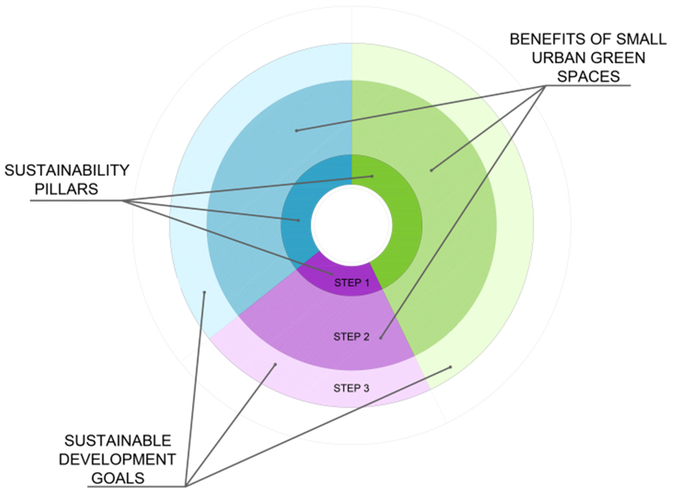
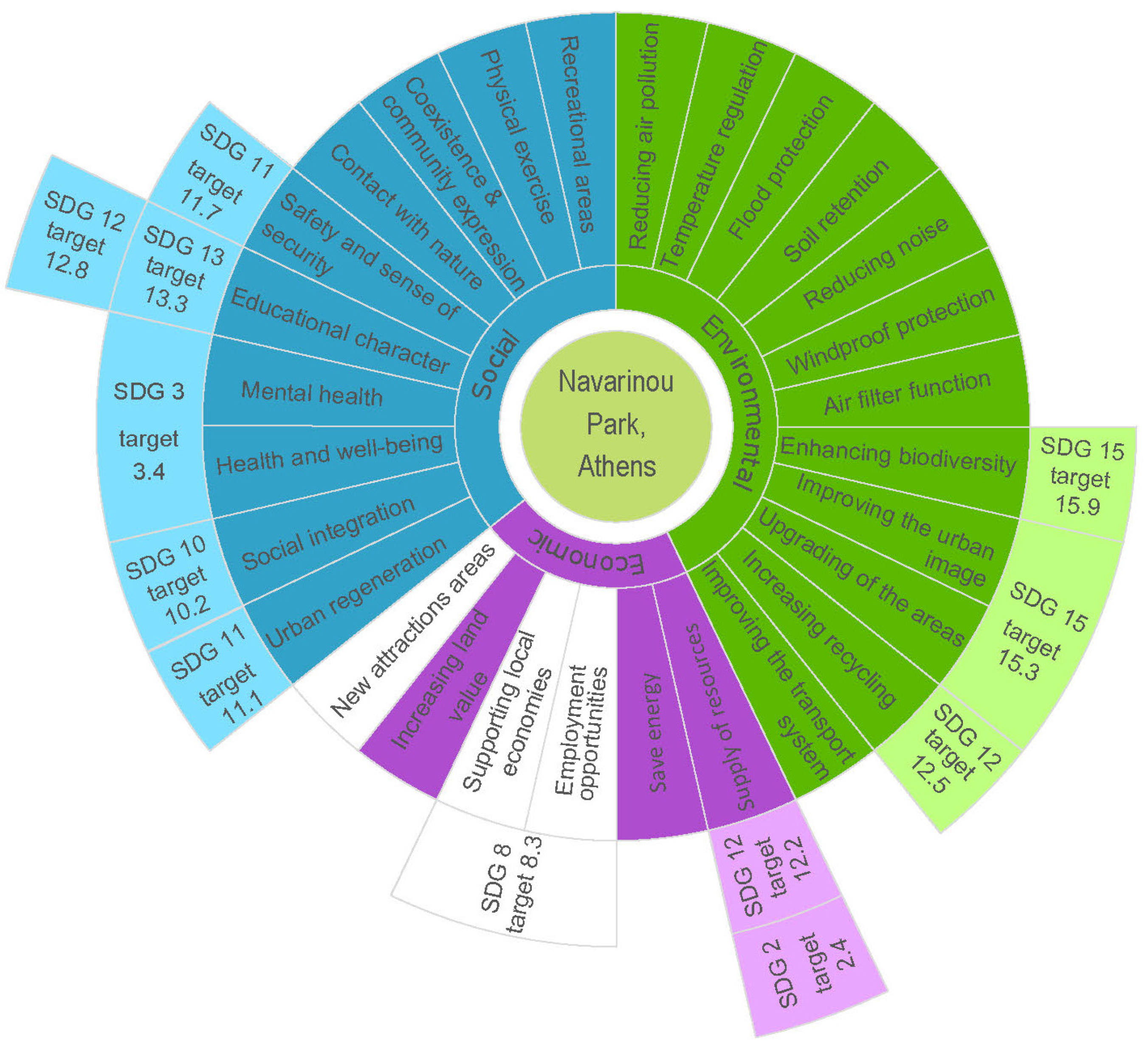
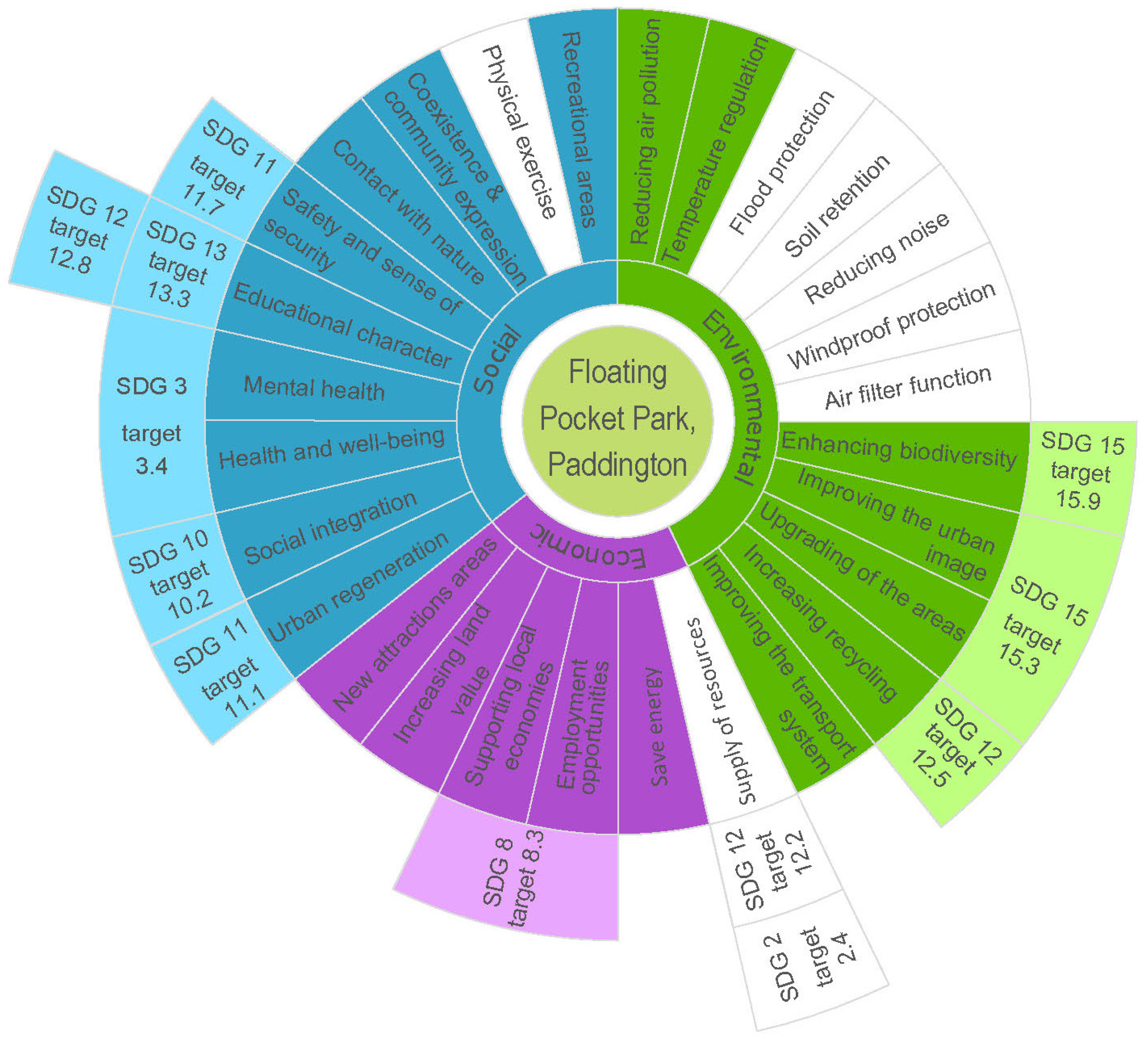
After identifying the sustainable development goals supported by pocket parks with their benefits to the environment, society, and the economy, a diagram tool is formed for illustrating those benefits. The diagram is based on the 17 objectives and sub-objectives of sustainable development as defined by the UN. Out of the 17 Sustainable Development Goals, eight SDGs (namely Goals 2, 3, 8, 10, 11, 12, 13, and 15) are directly related to aspects affected by the existence of pocket parks in the urban fabric. The diagram is structured according to the three pillars of sustainability: environmental, social, and economic. In the center of the diagram is the pocket park, while the surrounding layers represent the pillars of sustainable development (Step 1/
Figure 3). Consequently, the benefits of pocket parks are divided and presented based on the pillar sectors (Step 2/
Figure 3). Finally, the outer layer presents the UN goals and targets associated with each identified benefit. In the same layer, a reference is made to the specific sub-objective of the main goal. (Step 3/
Figure 3).
The format of the tool, therefore, has three layers, with the pocket park at the center. In the first layer, the pillars represent sustainable development; the second layer presents the benefits that this public green space offers to the environment and the benefits provided by this public green space to the economy and society; and in the last layer, the UN goals and sub-objectives that each of these benefits serves are assigned (
Figure 4).
This multi-criteria decision-support tool enables public institutions and planners to evaluate potential green infrastructure projects against the strategic objectives of each respective sector. By operating as a structured evaluation framework, the tool is used to assess and validate the long-term project viability during the formal municipal approval and screening processes. Synthesizing this information into a conceptual framework, a scheme showing the range of cross-sectoral benefits may optimize spatial design, while ensuring a proper combination of elements, maximizing the multi-objective goals achieved by the new green infrastructure intervention. The framework can assist landscape architects during the design process, as well as any individual or community involved in the creation of public spaces.
Subsequently, this stage of the research seeks to evaluate existing pocket parks. Utilizing the developed multi-criteria framework, this section assesses the extent to which the defined objectives are achieved within each case study.
3.2. Applying the Multi-Criteria Evaluation Tool—Case Studies
By comparing the first examples, the benefits they offer to sustainable development are evaluated using the multi-criteria evaluation tool created in
Section 3.3 (
Figure 2 and
Figure 3). The diagram generated for each one of the four pocket parks illustrates the benefits and evaluation criteria satisfied by the characteristics of each park (inner layer), and the 8 out of 17 objectives they satisfy as defined by the UN and the 2030 Agenda for SDG (outer layer). An overall sustainability rating of each park is assigned on the diagram.
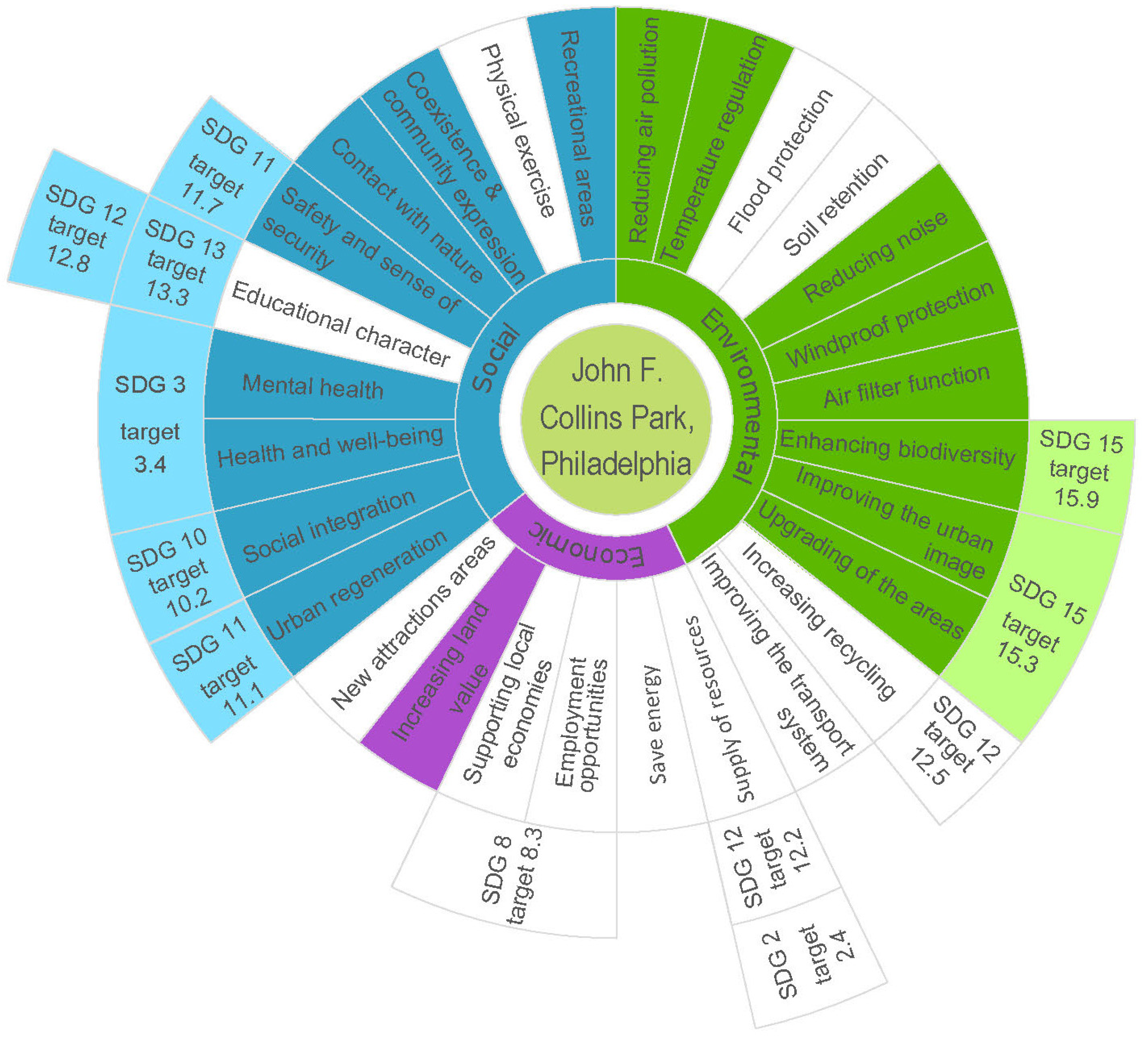
In the case of the John F. Collins Park, the benefits to the environment are considerable due to the presence of greenery and even tall trees, but its contribution to flood control and soil retention is limited, as most of the park is paved with hardscape material. The community benefits of the micro-space are pronounced due to its strategic position within a dense, mixed-use fabric of commercial enterprises and residential zones. Consequently, the park functions as a vital pedestrian anchor, offering an immediate sensory refuge and rest point for employees, shoppers, and residents during local business hours. The ground floors of the surrounding buildings already accommodate local commercial enterprises such as a pizzeria, a bakery, and various small-scale retail operations. Therefore, the creation of the pocket park did not directly generate new commercial attractions or employment opportunities. Nevertheless, its presence contributes to the enhancement of the area’s overall value. In a densely populated urban context, the introduction of green space improves the environmental quality, aesthetic appeal, and social livability of the neighborhood. Consequently, even without direct economic interventions, the park indirectly increases land and property values by making the area more desirable for both residents and visitors (
Figure 5).
Navarinou Park demonstrates strong environmental performance due to its diverse vegetation and limited use of hardscape materials. The concentration of paved surfaces within circulation paths increases permeability and strengthens the park’s ecological contribution. Furthermore, the integration of multiple functions within the park offers opportunities for rest, recreation, social interaction, and play, serving diverse user groups within the neighborhood. Although the park’s economic impact is modest compared to its environmental and social contributions, it still supports energy efficiency, microclimatic improvement, and local resource production. One of the collective design decisions made by residents was the establishment of an orchard featuring olive and citrus trees, as well as various fruit and vegetable plants, which further contributes to local resource production and environmental resilience (
Figure 6).
The Paddington Floating Park provides several economic benefits, such as the increase in land value or the creation of jobs with the bars opening within the park and the possibility of holding events, in addition to social benefits. Although the environmental benefits are comparatively limited relative to those observed in other parks—primarily due to the greening being confined to raised beds with low-lying vegetation—the most significant environmental feature is the floating greenery, which serves to attract avifauna. It should be noted, however, that this assessment tool does not allow quantitative measurements of individual benefits, but rather evaluates them qualitatively and as a proportion of the total environmental contribution (
Figure 7). Qualitative frameworks developed over the past decade have significantly reshaped the way various components of the built environment are understood, assessed, and valued [
60].
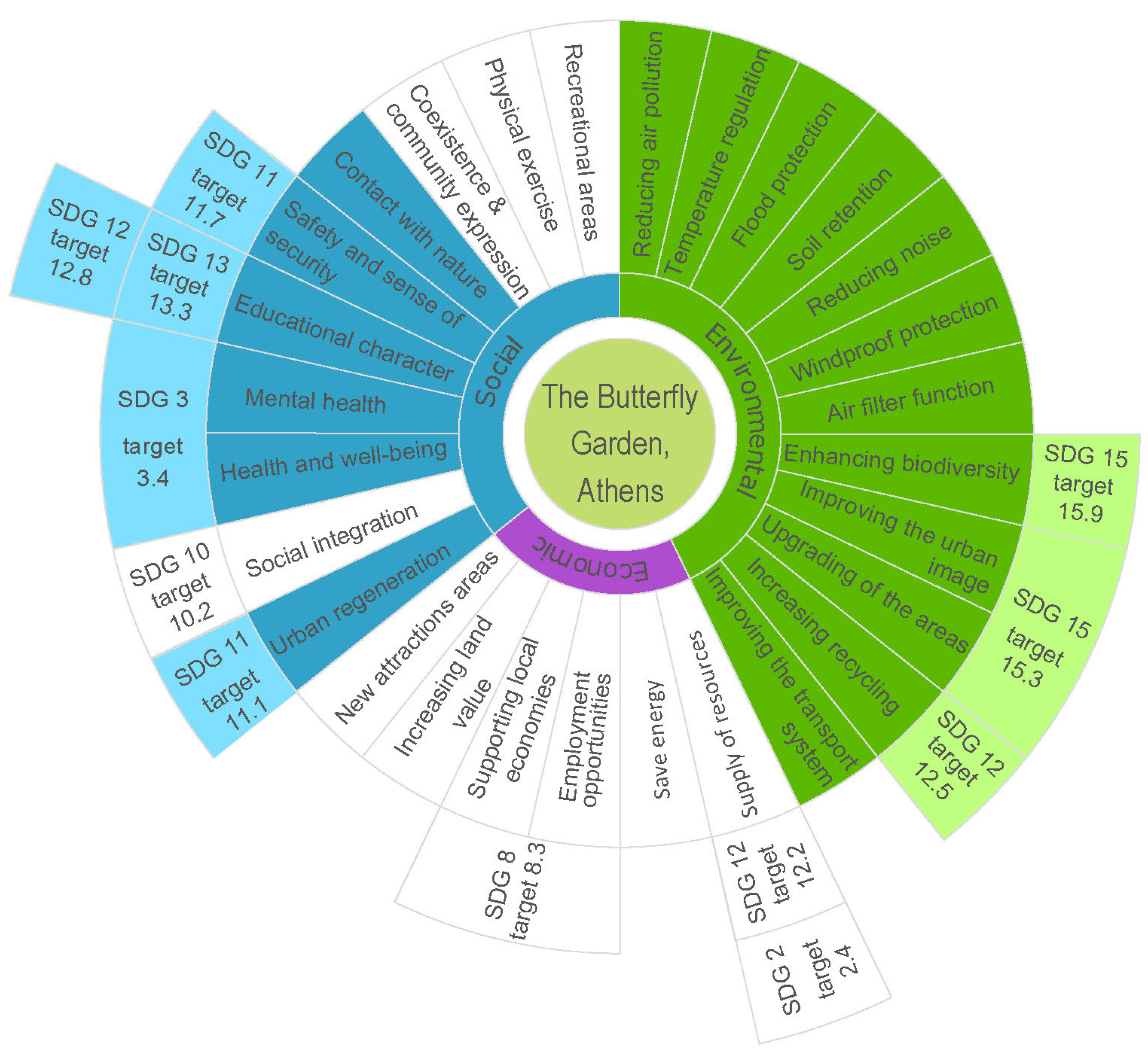
Similarly, the Butterfly Garden in Kypseli does not yield economic or social benefits to the same extent as the previously discussed examples. However, in a densely populated, predominantly residential neighborhood characterized by high-rise buildings, the presence of abundant, diverse plant species in a flower garden contributes to the formation of a localized ecosystem, providing a wide range of environmental benefits to the surrounding community (
Figure 8).
From the environmental point of view, even the smallest park, such as the Butterfly Garden, has several advantages, since its shared defined characteristics are greenery. While the lack of tall greenery, such as trees, may limit wind protection and shade-driven temperature reduction, the overall benefits of the park still significantly contribute to this sector and to the preservation of local ecosystems. Despite its significance, this sector has received limited economic attention, particularly regarding how the surrounding neighborhood might benefit from the park. This lack of economic engagement suggests a risk of future neglect and highlights a clear deficiency in the financial commitment of key local stakeholders—including residents, users, and nearby business owners—toward the park’s long-term maintenance.
3.3. Identification of Design Parameters
The design parameters that will be evaluated in this study are divided into three categories: spatial, social, and environmental.
Spatial, Social, and Environmental Parameters
Spatial parameters include all choices regarding the park’s design impact: plot size and boundaries, location and neighborhood type, visibility and the provision of multiple entrances, openness and clear separation from the sidewalk, surface materials, seating arrangements, and the selection of a focal point. These design parameters can be considered as practical guidelines for the design of functional and successful pocket parks.
The social parameters include the users, the functions of the park, and its benefits for the community. These parameters are determined by the context of the park’s environment, by the surrounding area, and its potential users.
The last category concerns the environment. It includes sustainable strategies for the park’s environmental design and choices aimed at providing the necessary conditions for environmental restoration. Additionally, it involves creating a network of green spaces in the city, connecting these public spaces with other areas of daily use to facilitate alternative mobility (
Table 2).
3.4. Detecting Parameter in Case Study Parks
Pocket parks, as already mentioned, have neither specific characteristics nor a precisely defined size. They may have different forms, areas, uses, users, and even materials and special compositions. A comparison of the case studies presented in the previous section, however, can reveal similarities between them (
Table 3).
Table 3.
Comparison of case studies.
Table 3.
Comparison of case studies.
| | John F. Collins Park, Philadelphia, United States | Parko Navarinou, Athens, Greece | Floating Pocket Park, Paddington, United Kingdom | The Butterfly Garden, Kypseli, Greece |
|---|
| Spatial Characteristics | Size | 360 sqm | 1500 sqm | 700 sqm | 100 sqm |
| Location | Central Philadelphia, United States | Exarchia, Athens
Greece | Paddington, London, UK | Kypseli, Athens, Greece |
| Year | 1979 | 2009 | 2017 | 2020 |
Entrances/
accessibility | Controlled access from two sides | Unrestricted access from three sides | Unrestricted access from one side | Unrestricted access from one side |
| Openness | Two sides | Three sides | Four sides | One side |
| Type of City/Neighborhood | Dense commercial city center | Dense mixed-use residential neighborhood | Dense mixed-use residential neighborhood | Pure residential neighborhood |
| Surfaces and Covering Materials | Hardscape surfacing material,
Walls of concrete,
Natural soil | Dirt and gravel
Limited hard surfacing material on the central paths and mosaic flooring | One float platform with hardscape material and flower beds, one with artificial turf and low planting beds, and a separate small pontoon only with greenery | Hardscape surface Flower beds |
| Urban Equipment | Fixed and movable chairs | Fixed improvised seating benches made of wood and stone | Removable deckchairs and beanbags
Seating fixed benches on both floats | Two fixed benches |
| Focal Point | Fountain, trees,
ivy-climbing plants on the walls | Gathering place around a plane tree
Amphitheater and stage, Children’s playground
Orchard with olive trees, citrus trees, and fruit and vegetables
Perimetric planting | Fixed shade canopy
pavilion-bar
Flower beds with low vegetation
Float with appropriate planting to attract birds and bees | Flower beds with a low evergreen fence, flowering shrubs
Vertical green garden on one side of the wall
Special signs with plant information
Structures for nests of insects |
Spatial Characteristics
Size—Location: all four parks occupy a single plot of land. Specifically, in the case of the floating park, the ‘plot’ was created by occupying a river surface area rather than an existing land-based site.
Openness—Entrances/Accessibility: The entrances to the park vary significantly. The John F. Collins Park offers visibility from both narrow sides—framed by buildings, plantings, and additional design elements—and features two entrances that are controlled due to the site’s private status via a metal gate that maintains visibility into the park. The other two parks have a specific passageway for an entrance. Although flower beds enclose them, they are low enough to offer full visibility into the park from the street, as shown in
Figure 9.
City/Neighborhood Type: In the case of the John F. Collins Park, the park is located in a commercial district, whereas the Butterfly Garden (Kypseli area) is in a purely residential neighborhood, and the remaining two (Navarinou Park, Floating Pocket Park) are in neighborhoods of mixed-use.
The materials used across the parks show minimal variation, typically consisting of hardscaping for pathways or broader paved areas, interspersed with soil beds to accommodate large trees or low vegetation, as seen in the case of the Floating Park.
Urban Equipment—Park Centerpiece: The primary element of urban furniture across all case studies is the bench, with even the smallest park—the Butterfly Garden—featuring traditional seating units. Each of the four parks includes a central focal point: a prominent tree or flowerbed in the Butterfly Garden, a communal gathering space around the banana tree in Navarinou Park, and a bar with a canopy structure in the Floating Park. These central elements serve both functional and symbolic roles, enhancing spatial organization and encouraging social interaction.
3.5. Parametrizing a Small Urban Green
In recent years, modern architectural design has placed a strong emphasis on mathematical topological models and the parametric processing of architectural proposals using appropriate software [
61]. Parametric design generates families of outcomes with evolutionary characteristics, rather than singular, definitive design solutions. Design proposals that depend on selected parameters ultimately lead to the formulation of a set of assembly principles, achieved through the construction of appropriate topologies [
61].
The term topology refers to a branch of geometry in which quantitative aspects are entirely absent, rendering it purely qualitative in nature. Topology, also known as qualitative geometry, examines the properties of geometric objects that remain invariant under continuous deformations. The concept first emerged in the 18th century, illustrating that certain problems are independent of the precise shape or dimensions of the objects involved and instead depend on the relational configurations among them.
The primary aims of this study are to identify and document the design factors of a pocket park and, subsequently, to represent these factors schematically and independently of metric constraints through the application of specialized design software. The very essence of parametric design lies in the relationships between elements and parameters [
62]. Architecture emerges from the correlation, reconciliation, and interaction among these parameters.
The design process is conducted using Rhinoceros 3D along with Grasshopper software. The integration of these two platforms enables the development of parametric applications. Within this environment, various functions and their corresponding parameters are visualized and interconnected, forming a network that represents the underlying information structure. Simultaneously, the resulting objects, their interrelations, and variations arising from parameter adjustments are translated into geometric forms. Spatial parameters are assigned numerical values to enable the systematic linkage of parameters and concepts in the analysis of the relationships outlined below [
63].
3.6. Identifying Quality Characteristics of a Pocket Park
The elements generated from spatial design parameters are used to assess the park’s spatial performance, while also allowing the integration of social and environmental factors within the design process. Qualitative characteristics are combined with spatial parameters to examine the relationships that can be developed between them. Only the spatial characteristics are selected, with the aim of generating results that spatially capture the essential elements and demonstrate the adaptability of the pocket park within any urban void. This approach highlights the potential of such spaces to be replicated across multiple urban voids, contributing to the formation of a continuous urban green network. In
Table 4, the relationships evaluating the performance of each factor and parameter are analyzed. Numerical values are assigned to spatial parameters, facilitating the linking of parameters and concepts in mapping the relationships described below.
To illustrate these relationships, this study draws on the work of Whyte [
48], whose empirical research on the social life of small urban spaces provides a foundational behavioral framework for the parametric methodology that follows. Through direct observation and user questionnaires in New York City squares and small parks, Whyte demonstrated that the success of a public space is not determined by its absolute dimensions or the esthetic qualities of surrounding buildings, but by the relational configuration of its spatial elements: the proximity of seating to circulation nodes, the degree of openness to sunlight, the placement of focal features along movement axes, and the presence of multiple entry points that encourage incidental use. In Whyte’s framework, space is understood not as a fixed metric object, but as a field of spatial relationships that either enable or suppress social behavior [
48].
This relational understanding of space provides the epistemological basis for adopting a parametric topological approach in the present study. Parametric design, as implemented through Grasshopper, operates precisely on relationships rather than on fixed dimensions: it encodes the dependencies between spatial elements—how the position of an entrance determines a circulation axis, how that axis governs seating placement, how seating placement in turn defines zones of enclosure and openness. This logic mirrors Whyte’s own analytical framework, in which the determinants of spatial quality are relational and context-dependent rather than absolute and universal. Parametric topology is therefore not merely a practical tool for generating adaptable layouts; it is epistemologically aligned with a behavioral theory of space in which qualitative spatial relationships, rather than quantitative dimensions, are the primary carriers of design meaning. This alignment justifies the translation of Whyte’s observational findings into parametric constraints and positions the Grasshopper routine as a computational formalization of a theoretically grounded spatial model. Based on these observations, plot size and surrounding building configuration are treated as primary inputs in the design process, from which the relational arrangement of all other spatial elements is algorithmically derived.
3.7. Approaching a Pocket Park with the Parametric Design Methodology (Using Grasshopper)
Scope clarification: The parametric routine developed in this study generates spatial design guidelines—a relational layout of paths, focal zones, vegetation zones, and urban furniture—derived from the qualitative characteristics of a given plot and its surrounding context. It does not constitute a performance-verified or engineered design solution. The outputs do not include structural calculations, drainage engineering, microclimate simulation, or acoustic modeling, nor have they been validated against post-occupancy behavioral data. The routine is intended as a decision-support tool for the early design stage, providing landscape architects and urban planners with a spatially coherent starting point that guarantees the presence of the essential characteristics of a pocket park, while leaving all subsequent design, engineering, and material decisions to the responsible professionals. The files of Rhino and Grasshopper can be found as
Supplementary Material.
The spatial outputs of the routine are amenable to structured validation through two complementary approaches: quantitatively, via Isovist analysis metrics applied to the generated layouts (e.g., mean visibility radius, Isovist area coverage, connectivity values across the plot surface) and qualitatively, via structured expert review in which landscape architects assess the generated configurations against the design parameters established in
Section 4. Both validation pathways are identified as priorities for the next research phase.
Future iterations of the routine should incorporate a social ergonomics layer for urban furniture placement, encoding orientation rules (face-to-face seating, alignment to focal point) and explicit microclimate criteria (solar angle, prevailing wind direction) as additional parametric constraints, bringing the model closer to the full spectrum of social sustainability criteria identified in
Section 3.
Green spaces depend to a great extent on the amount, type, and arrangement of vegetation and other materials in the available space [
64]. Landscape architects create a park by working with its roof, represented by tree canopies; its walls, represented by shrubs or trees; and its floor, represented by grass, low plants, or other hardscape materials [
65]. With such a metaphor, all the necessary elements of the park are presented by surfaces, lines, or points. With these geometric elements and using their properties, the connections and relations corresponding to the necessary spatial characteristics are formed.
One of the spatial characteristics discussed above is the openness of a green space. Openness, or conversely enclosure (5), is determined primarily by the spatial boundaries of the area. It is initially defined by the physical characteristics of the site itself and its existing edges—such as the plot’s sides and any adjacent buildings. Subsequently, elements such as fencing and its design, vegetation, and built structures introduced to support park activities further contribute to shaping the perceived and functional boundaries of the space.
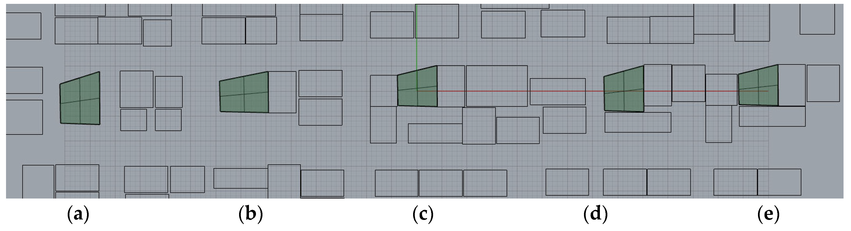
Pocket parks, when developed in densely populated urban areas, are typically established on vacant plots situated between apartment buildings. They are often enclosed by party walls, making the degree of enclosure—defined by the number of surrounding sides—their primary typological characteristic. Such vacant plots may be located at various positions within the urban fabric: at the center of a block, on a corner, spanning the block’s width, or occupying an entire block. Consequently, they may be enclosed on three sides, on two sides, or remain open on all sides, without enclosure by adjacent party walls. [
66]. To visualize the relationships and outcomes of the aforementioned parameters, representative plots were selected based on their degrees of enclosure [
67] and the potential classification of pocket parks according to plot configuration and boundary conditions (
Figure 10).
3.7.1. Parametric Design Methodology
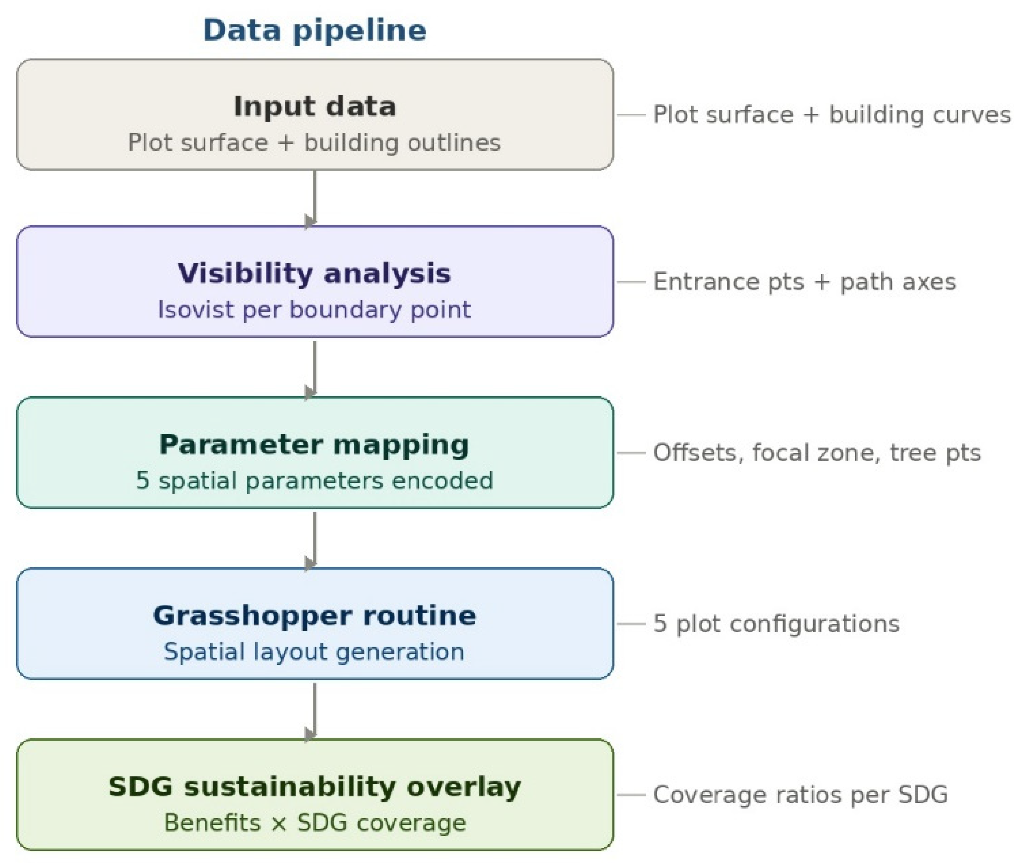
The methodology performed is based on the principles of Benedict’s theory. According to [
68], an Isovist is the set of all points in space that are visible from a specific vantage point within a given environment. Once a position is modified, the size and shape of an Isovist may be modified. The resulting measurements create a set of scalar Isovist fields which may form an alternative description of the environment. This methodology has been performed in similar studies, such as in [
69], where the authors used computer vision to quantify street-level factors in streets in Atlanta, GA, USA. The pipeline of the proposed parametric design methodology is described in
Figure 11.
| Pseudocode by Component Groups |
| | Initialize System |
| | Load Grasshopper environment |
| | Define global parameters |
| | Set environmental evaluation criteria |
| | Set SDG assessment metrics |
| | Input Stage |
| | Import site boundary geometry |
| | Import topographical and spatial constraints |
| | Import environmental datasets |
| | Define circulation and accessibility parameters |
| | Generate reference coordinate system |
| | Visibility Analysis Stage |
| | Subdivide site into analysis points |
| | FOR each analysis point: |
| | Generate Isovist field |
| | Calculate visibility range |
| | Measure openness and connectivity |
| | Store visibility values |
| | End For |
| | Rank all points according to visibility performance |
| | Select optimal visibility nodes |
| | Access and Node Generation |
| | Define primary access points |
| | Define secondary interaction nodes |
| | Connect nodes through circulation logic |
| | Generate accessibility network |
| | Parametric Mapping Stage |
| | Assign spatial parameters to selected nodes |
| | Map environmental variables onto geometry |
| | Define adaptive geometric relationships |
| | Establish transformation rules |
| | Geometry Generation Stage |
| | Generate base geometry |
| | Apply parametric transformations |
| | Modify geometry according to visibility data |
| | Adjust density and spatial distribution |
| | Generate surfaces and volumetric configurations |
| | Spatial Evaluation Stage |
| | Calculate distances and connectivity |
| | Measure surface areas and spatial ratios |
| | Evaluate environmental performance |
| | Assess daylight and openness conditions |
| | Analyze circulation efficiency |
| | SDG Multi-Criteria Evaluation |
| | Compare spatial results with SDG indicators |
| | Measure environmental benefits |
| | Evaluate accessibility and inclusivity |
| | Assess spatial sustainability performance |
| | Optimization Stage |
| | Rank generated configurations |
| | Select highest-performing solution |
| | Store optimal geometry and metrics |
| | Output Stage |
| | Export final geometry |
| | Export environmental indicators |
| | Export SDG assessment results |
The parameter size (Parameter 1) corresponds to plots of varying dimensions, and the location (Parameter 2) corresponds to the surrounding buildings that form the neighborhood. The five plots created above are introduced as surfaces, while the surrounding buildings are introduced as curves. These are hypothetical plots within conceptual urban blocks (
Figure 5). The Grasshopper definition isolating the plot geometry to determine spatial coordinates is shown in
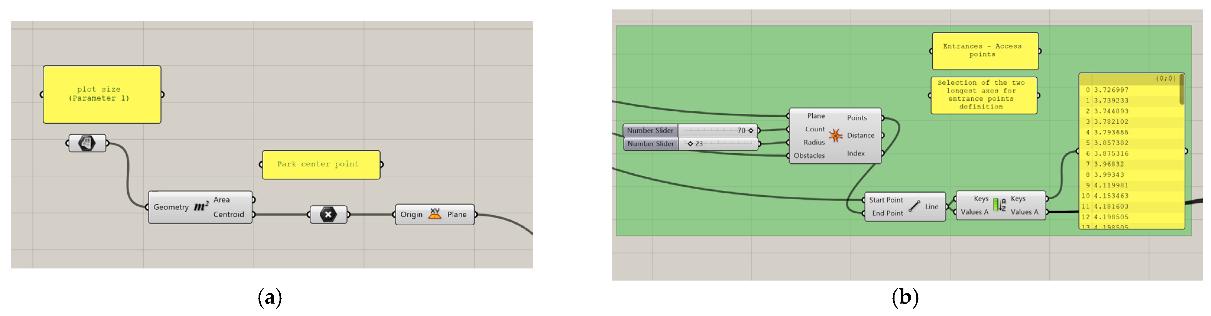
Figure 12a. The raw boundary surface is passed through an area analysis component to extract the geometric centroid. This center point represents the theoretical spatial anchor used to construct a local coordinate plane for the central programmatic features of the park. Firstly, the plot is inserted in the surface parameter (
Figure 12a). The type of city (Parameter 3) is represented by the building density of the neighborhood, which is determined by the number of buildings in the surrounding area. The visual scripting pipeline demonstrating the algorithmic selection of park access points is shown in
Figure 12b.
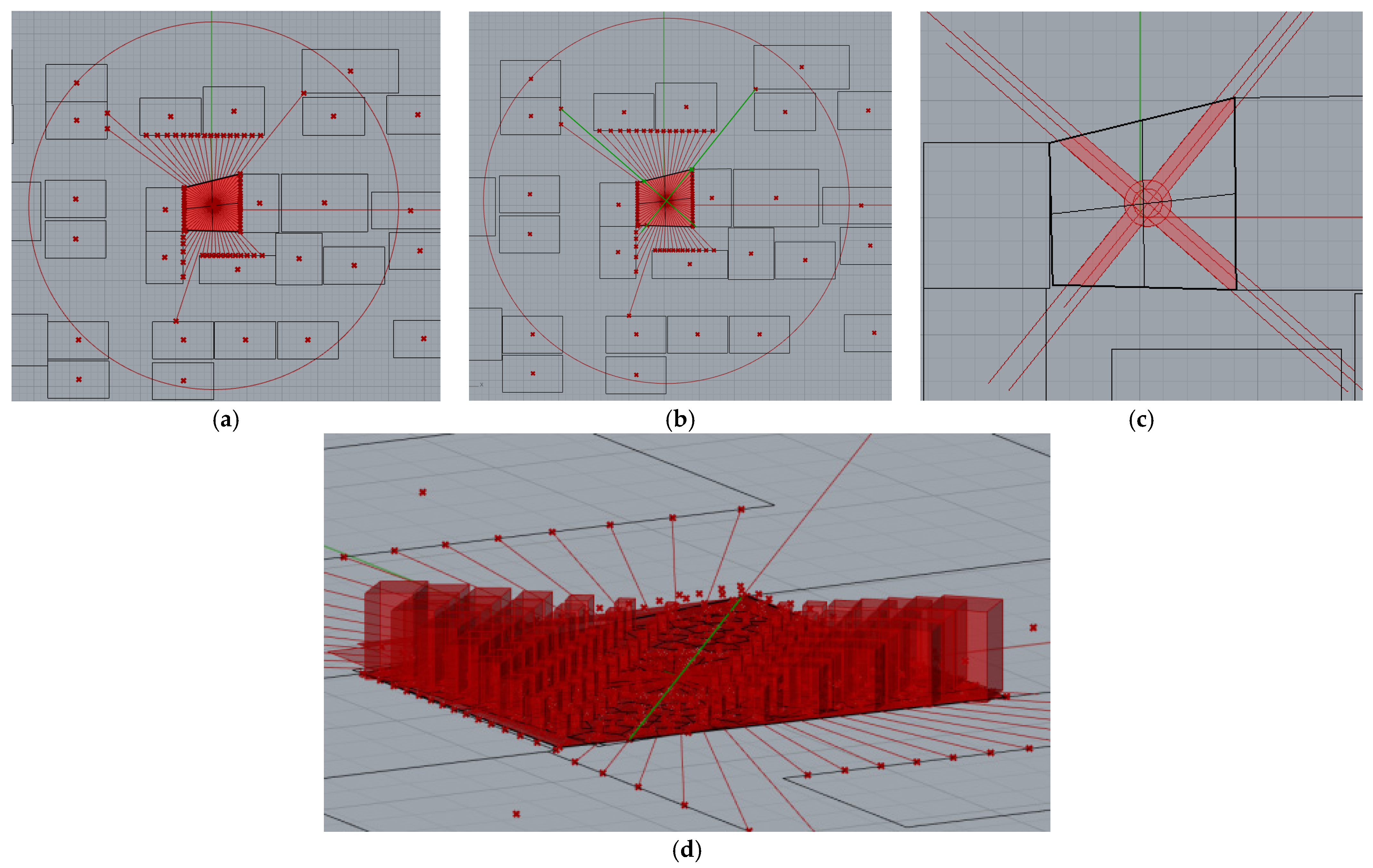
The definition of park entrances (Parameter 4) is based on the most visually exposed points along the park’s boundary. While entrance location is conventionally determined through pedestrian flow counts and street connectivity analysis, such data are unavailable at the early parametric design stage; an Isovist-based proxy is therefore adopted. This selection is grounded in Benedikt’s Isovist theory [
68] which establishes that the maximum-length Isovist ray indicates the direction of greatest spatial depth into the surrounding environment, and in Space Syntax research demonstrates a robust correlation between maximum ray length and pedestrian movement intensity in dense urban grids [
68,
70]—making the most visible boundary point also the most connected. This is a principled approximation: where site-specific flow data are available, they should supplement the Isovist criterion. By applying the Isovist command (
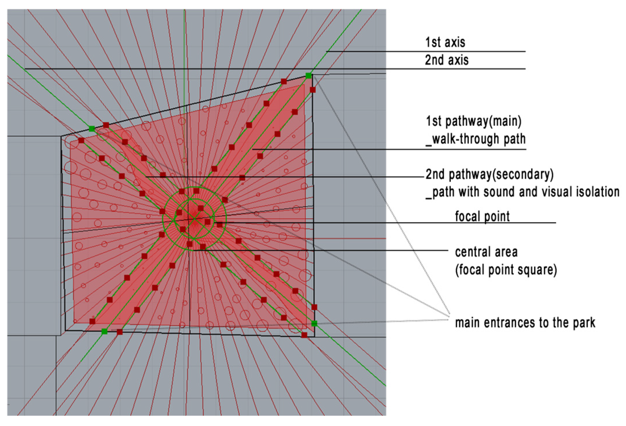
Figure 12b), the boundary point with the longest Isovist ray is selected as the primary entrance; the second longest yields the secondary entrance (
Figure 13a,b). These points define the central movement axes, from which the circulation areas (Parameter 6) with hardscape materials are derived, extending toward the opposite edge of the plot and creating through-ways that guide movement across the park (
Figure 12b).
The focal point of the park (Parameter 8) is placed at the center of the shape of the plot (Parameter 1), as it is formed from its geometry (
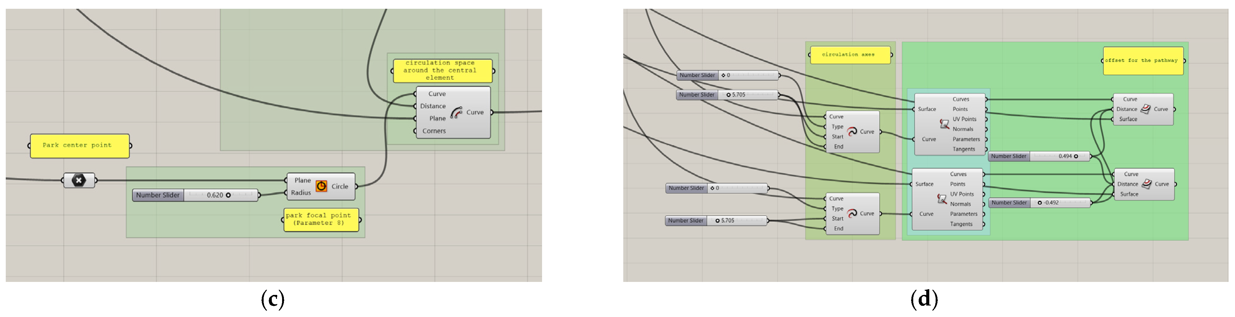
Figure 12a). At this center point, a circle is formed to accommodate the focal point—an element derived from the design and dependent on the uses and functions assigned to the park. The details of the parametric script governing the central node generation are shown in
Figure 12c, and the algorithmic routine detailing the construction of the primary and secondary circulation pathways is shown in
Figure 12d. The generation of through-routing pathways rests on projecting linear circulation axes across the host site geometry. The lines of the central axes of the movement (
Figure 12d) and the circle of the central element (
Figure 12c) are offset to form the surfaces of the paths.
Openness (Parameter 5), beyond the unbuilt sides of the plot and the surrounding structures, also refers to the additional boundary created by the fencing that delineates a green space from the street—whether this boundary is artificial, natural, or composed of other elements may influence the park’s perceived openness. In assessing visibility, consideration is given to the spatial volumes within the park that either enhance or restrict visual access. Visibility is essential for fostering a sense of safety, yet a degree of visual limitation is equally important to provide a sense of isolation from street activity and urban noise. Consequently, in areas beyond these zones of intensity and as distance from the central axes increases, trees or other volumetric features are introduced and gradually intensified, reinforcing both spatial depth and visual hierarchy.
Subsequently, a series of points is generated across the surface of the park. The points located outside the central area correspond to potential tree volumes or other spatial elements, creating a central zone free of vegetation and built elements—except for the originally defined core area—thus ensuring unobstructed visibility along the primary circulation axis. The secondary movement axis is redefined by identifying the shortest route that avoids volumetric obstacles.
Urban furniture elements, including seating benches, waste bins, and lighting fixtures, are positioned along the movement axes of park users; their delineation lines are divided to determine base locations. Bench density is adjusted to the typology and density of the surrounding neighborhood (Parameter 3). Bench locations are structurally co-located with tree placement zones, ensuring natural shading by adjacent canopy volumes—a form of microclimate-aware placement encoded in the sequence of operations rather than as a separate parameter. Explicit bench orientation and social ergonomic criteria (face-to-face configurations, alignment to focal point) are acknowledged as requiring a secondary parametric layer and are identified as a direction for future research.
Luminaires and waste bins are positioned at regular intervals to ensure adequate illumination and to meet the functional requirements of areas with high pedestrian activity. Additional lighting is installed at the intersections of offset lines, where circulation routes intersect with one another and with the perimeter boundaries of the plot (
Figure 14). Although the secondary path has been redefined with a curved alignment, the seating benches remain in their original locations—whether situated on hard or soft surfaces—and are positioned among the trees. This configuration maintains the intended meeting points along the main circulation axes while simultaneously providing resting areas that offer both visual and acoustic isolation from the adjacent streets.
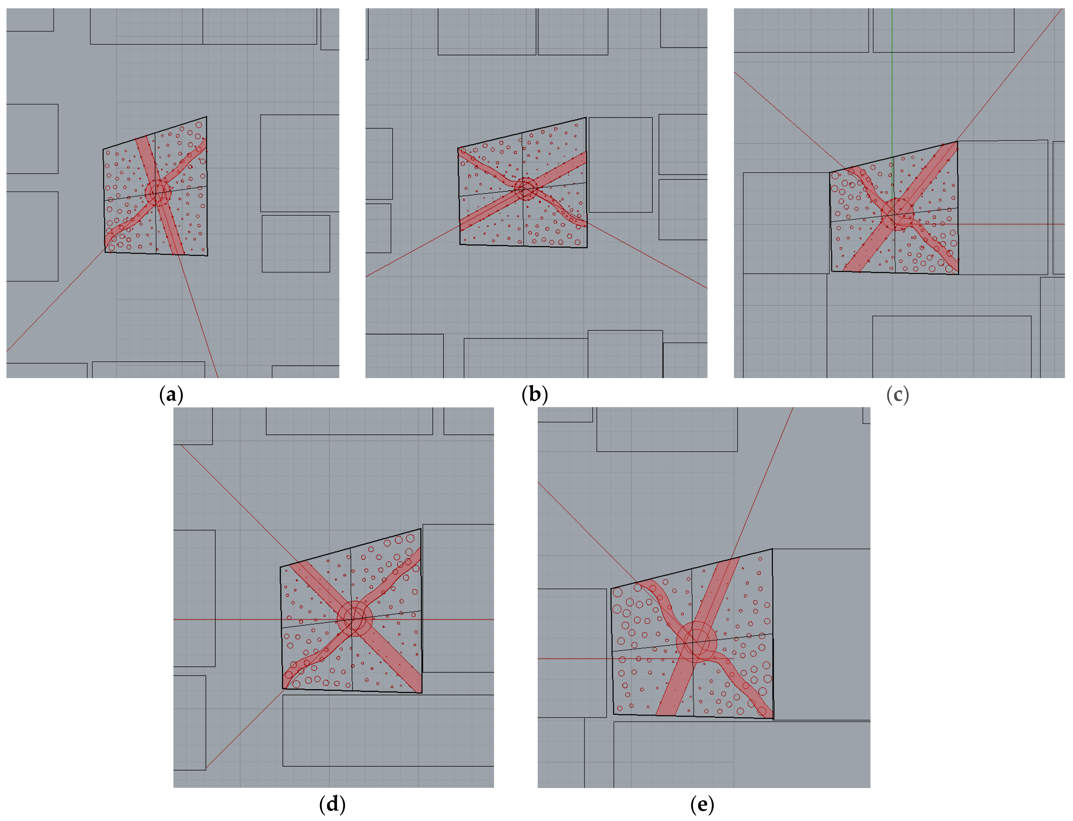
3.7.2. Application Results on the Five Plots
The routine was applied to five hypothetical plots systematically selected to represent the complete typological range of urban infill configurations in dense Greek cities: from fully open (zero party walls) through three single-wall variants to maximally enclosed (three party walls), covering the structurally distinct enclosure typologies of central Athens [
67]. This approach isolates the typological variable from confounding site-specific factors and is discussed further below; application to real-world plots is identified as the next validation step (
Figure 15).
The process is designed to receive and input the park surface and the boundary curves of the surrounding buildings and to automatically generate the corresponding relationships among the spatial parameters within each plot. This approach does not seek to standardize the design of pocket parks; rather, it aims to represent their qualitative characteristics by linking the spatial elements that define them and establishing relationships among these elements based on insights derived from the theoretical study of design parameters presented in the preceding sections.
The initial formulation of the command sequence was undertaken on Plot 3 and subsequently applied to the remaining plots to evaluate its adaptability and to identify any necessity for further redefinition or refinement.
4. Discussion
4.1. Cross-Case Synthesis: Descriptive Coverage Ratios and Evaluation Constraints
To enable a comparative overview of the four case studies, a descriptive coverage ratio is computed for each park, defined as the number of benefits qualitatively identified as present divided by the total number of benefits in the multi-criteria framework (n = 28). This ratio is explicitly not a performance score: it does not weight individual benefits by importance, does not measure the degree to which a benefit is achieved, and does not carry statistical validity. It is a qualitative evaluation, a simple presence/absence count that is used descriptively and is intended solely to facilitate a rapid visual comparison of the breadth of sustainability coverage across parks of different typologies, sizes, and contexts.
The ratios are as follows: John F. Collins Park—17/28 (61%); Navarinou Park—25/28 (89%); Floating Pocket Park, Paddington—21/28 (75%); Butterfly Garden, Kypseli—18/28 (64%). These figures should be read as indicating that, for example, Navarinou Park satisfies the presence criteria for nearly nine out of ten identified benefit categories, while the Butterfly Garden satisfies approximately six out of ten. The difference between these two values does not imply that Navarinou Park delivers those benefits more effectively, but only that it addresses a broader range of benefit types.
This descriptive approach is acknowledged as a methodological limitation of the current study. A more robust assessment would require either (a) a weighted multi-criteria decision analysis (MCDA) framework in which each benefit is assigned a contextual weight reflecting local planning priorities, or (b) a quantitative validation linking spatial parameters to measurable outcomes such as temperature reduction, visitor counts, or biodiversity indices. Both directions are identified as priorities for future research. In the present study, the coverage ratios serve their intended purpose: to demonstrate that the multi-criteria tool is operational and produces differentiated, interpretable outputs when applied to real case studies, while remaining transparent about its qualitative and descriptive nature.
4.2. Evaluation of Parametric Outputs
Grasshopper software aims to visualize the parameterization process of a pocket park by translating spatial characteristics onto hypothetical plots. The primary objective of this approach is to establish connections among the spatial design parameters identified in the study and to demonstrate the limited significance of the host plot’s size. A pocket park, therefore, is not constrained by the available land area or its specific location. Within this framework, the park surface and contextual boundaries are introduced as input data into the routine, from which the relationships among the remaining spatial elements are subsequently generated. These relationships are defined not by dimensional attributes, but by the qualitative characteristics of each element and their interdependencies within the spatial system [
71].
The routine is applied to each plot through the modification of the given surface, incorporating the specific plot geometry and the boundary curves of the surrounding buildings. During the application of the routine across the five plots, two instances required targeted parameter adjustments, the nature of which clarifies both the scope and the current limitations of the algorithm.
The first adjustment concerned the unification of the hardscape surface in plots where the offset paths of the two circulation axes. In these cases, the Boolean union of the two path surfaces produced fragmented geometry that required manual consolidation into a single continuous hardscape zone. This issue is a known limitation of offset-based operations in Grasshopper when axes converge at acute angles, and it does not reflect a conceptual flaw in the spatial logic; rather, it identifies a computational refinement needed in future iterations of the routine—specifically, the implementation of an automatic union tolerance parameter.
The second adjustment involved the redefinition of the Isovist segmentation from a continuous angular sweep to 16 discrete segments at 22.5° intervals. This was necessary in plots where two candidate entrance points fell in close angular proximity. The 16-segment discretization resolves this ambiguity by enforcing a minimum angular separation between entrance candidates. This refinement has since been incorporated as a fixed parameter in the routine and applies consistently across all plots.
It should be noted that these adjustments do not undermine the reproducibility of the workflow; both have been fully documented, and their triggering conditions are geometrically predictable. However, they do indicate that the claim of applicability to any plot should be understood as applicability to any plot with at least one open façade—a boundary condition that encompasses the vast majority of urban infill sites in dense Greek neighborhoods, but which should be stated explicitly as a scope limitation.
All spatial design parameter data of the pocket park were successfully represented through the parameterization process. In contrast, the environmental and social design parameters were not spatially mapped within the scope of this study. Environmental characteristics—such as those associated with climate data within the sustainable park design strategy—could be interpreted and spatially integrated at a subsequent stage of research. The present effort, however, focuses on demonstrating the pocket park as an optimal model for increasing urban greenery and providing accessible public spaces. Accordingly, the analysis centers on spatial design parameters to evaluate the park’s capacity for full functional development across a range of potential urban sites. This focus does not preclude future research phases involving the expansion of the parameter set and the incorporation of additional environmental and social variables.
By establishing a continuous data pipeline where raw plot boundaries are structurally processed through Benedikt’s Isovist algorithms, the model proves that the spatial utility of a pocket park is not fundamentally constrained by its physical area, but by its topological configuration.
Qualitative Performance Assessment of the Parametric Outputs
Although the present study does not involve the instrumented measurement of the generated layouts—a quantitative validation phase that is identified as a priority for future research—a structured qualitative assessment can be conducted by mapping each spatial output back to the design parameters and sustainability criteria established in
Section 3 and
Section 4.
Table 5 summarizes this mapping for the five plots.
Parameter 4; SDG 11.7: In all five plots, the Isovist-based entrance selection algorithm consistently positioned the primary entrance at the point of maximum visual exposure to the surrounding street network. The resulting circulation axes extend across the full depth of each plot, ensuring that no area of the park is more than one path-width from a through-route. This configuration directly addresses Whyte’s finding that multiple connected entrances increase incidental use, and satisfies SDG sub-target 11.7, which calls for universal access to safe, inclusive, and accessible public spaces.
Parameters 6–8; SDG 15.3, 15.9: The tree-point distribution algorithm assigns vegetation to all surface areas outside the hardscape paths and focal zone. In the five tested plots, the estimated soft-surface coverage—defined as the total plot area minus the path and focal zone surfaces—ranged from approximately 45% (Plot 1, free-standing plot with four open sides) to 68% (Plot 5, enclosed on three sides). This variation is a direct and geometrically predictable consequence of plot boundary conditions, confirming that the algorithm adapts green coverage proportionally to available surface, rather than imposing a fixed layout.
Parameters 7–8; SDG 3.4, 10.2: Bench placement along the divided path perimeters ensures that seating is distributed at regular intervals across all plots, with density scaled to surrounding building density (Parameter 3). The focal zone, defined at the geometric centroid of each plot, provides a clearly identifiable gathering point in all five configurations, regardless of plot shape or degree of enclosure.
Parameter 5; SDG 11.1: The progressive intensification of tree volumes away from the central axes creates a spatial gradient from openness (along the main corridor) to enclosure (at the plot periphery), replicating the balance between visibility—essential for perceived safety—and acoustic isolation from street noise that was identified as a key quality criterion in
Section 4.
It should be explicitly noted that these assessments are qualitative inferences grounded in spatial logic and supported by the literature, not the result of post-occupancy evaluation or computational simulation. A full performance validation—incorporating visibility graph analysis, solar access simulation, and greenery coverage metrics against observed usage patterns—is planned as a subsequent research phase and will require application of the routine to real-world sites rather than hypothetical plots.
The empirical application of the multi-criteria framework to four diverse case studies, paired with the execution of the generative Grasshopper routine across five distinct boundary typologies, highlights the potential of digital decision-support tools in micro-scale urban greening. Rather than treating pocket parks as isolated, static landscape fragments, the methodology presented in this study operationalizes them as dynamic spatial systems.
5. Conclusions
Pocket parks encapsulate many of the benefits typically associated with larger urban green spaces, such as mitigating the urban heat island effect, preserving ecological balance, and fostering social inclusion. Integrating such spaces at the neighborhood scale generates multidimensional environmental, social, and economic benefits, thereby making urban sustainability more tangible and attainable in everyday life. Documenting these benefits enables the development of a multi-criteria evaluation tool designed to assess pocket parks based on the proportion and range of benefits they provide, in alignment with the 17 United Nations Sustainable Development Goals (SDGs) and their respective sub-targets. This tool serves as a framework for evaluating the design and performance of small urban green spaces through the lens of sustainability.
Beyond their importance and benefits within the urban fabric, it is essential to identify the defining characteristics that distinguish pocket parks from other forms of urban green space. The analysis and comparison of case studies reveal that, while their size may vary considerably, it is less critical than other design parameters. Pocket parks demonstrate a high degree of adaptability to different site typologies and neighborhood contexts; their success largely depends on how effectively they respond to local needs and engage site users. The literature further indicates that neither their dimensions nor their specific characteristics are rigidly defined, allowing for flexibility in both design and function according to contextual conditions.
The design parameters of a pocket park were identified in relation to its spatial, social, and environmental characteristics. These parameters were examined with respect to size, location, urban context, accessibility, openness, materials and components, functional uses, target user groups, and the intended purposes of those functions. The objective of this parameter inventory was to consolidate all factors that must be considered in the design of a functional pocket park. Furthermore, the study of these parameters and their interrelationships ensures the successful adaptation of the park to diverse sites and urban contexts, resulting in the creation of cohesive and efficient small green spaces. Despite their limited scale, pocket parks exhibit a notable degree of complexity, while simultaneously maintaining an appearance of simplicity by effectively integrating their essential characteristics—greenery, seating areas, and a balance between enclosure and visibility.
The need for the easy adaptability of pocket parks emerges from the fragmented and often irregular morphology of the vacant plots available for their development. In the context of the Greek urban environment—and particularly within the dense urban fabric tissue of Athens—such locations typically correspond to small, unused parcels of land embedded within the city’s built environment. Given that every neighborhood benefits from the presence of accessible green space, virtually any vacant plot could serve as a potential site for a pocket park. This condition of spatial limitation underscores the need for a design framework that guarantees the inclusion of essential elements without constraining creative freedom. Such a framework may be established through the method of parameterization and the use of appropriate computational design tools, such as Grasshopper software.
By linking the input data within the selected software environment, the process generates a family of results rather than a single definitive solution. When tested across various potential urban gaps, two primary parameters—the plot and the surrounding buildings—are introduced, producing outcomes that differ in form but share consistent qualitative characteristics. This confirms that the spatial design characteristics of pocket parks and their interrelationships can be successfully identified and translated into parametric logic, rendered computationally through Grasshopper to produce spatially coherent design outcomes. Crucially, the parametric routine is engineered to yield spatial design guidelines, rather than performance-certified solutions. The generated layouts define the relational configuration of spatial elements—circulation, enclosure, vegetation placement, and focal points—in accordance with the qualitative parameters identified in the study. They do not replace professional engineering judgment, environmental simulation, or community co-design processes. Their value lies in establishing a reproducible, theoretically grounded spatial framework that can be adapted, refined, and validated through subsequent design development phases. Given that one of the main challenges of this type of green space is its limited and often irregular area, the parameterization of spatial values and characteristics—independent of plot size and shape—ensures the preservation and interconnection of the essential attributes that define a spatially successful pocket park. This demonstrates that a replicable sequence of commands can indeed be established and applied to any vacant urban plot, guaranteeing the presence of all necessary spatial characteristics regardless of the plot’s size, shape, or urban context. Moreover, the comparison of case studies demonstrates that the four examined pocket parks exemplify this adaptability and transformative capacity, confirming their effectiveness regardless of scale or neighborhood typology.
In conclusion, the identification of the design parameters of pocket parks—their defining spatial, social, and environmental characteristics—and the subsequent parameterization of these values can generate a spectrum of adaptable design solutions. These solutions have the potential to guide the effective realization of pocket parks and the maximization of their environmental and social benefits, independent of the spatial constraints inherent in the limited urban voids of densely populated cities. Furthermore, this approach establishes a methodological foundation for future research, enabling the integration of additional parameters and the refinement of adaptive design strategies for sustainable urban development.