Article

Quantitative Morphological Resolution of Preservation–Renewal Conflicts for “Shanghai-Style Jiangnan” Villages, China

College of Architecture and Urban Planning, Tongji University, Shanghai 200092, China
*
Author to whom correspondence should be addressed.
Land 2026, 15(5), 798; https://doi.org/10.3390/land15050798
Submission received: 31 March 2026 / Revised: 2 May 2026 / Accepted: 6 May 2026 / Published: 8 May 2026
(This article belongs to the Special Issue Rural Space: Between Renewal Processes and Preservation)

Abstract

Against the backdrop of rapid global urbanization, peri-urban villages universally face the dual dilemmas of landscape homogenization and the imbalance between heritage preservation and functional renewal. As a typical representative, the “Shanghai-style Jiangnan” villages feature an open water–land chessboard pattern and linear water-house parallel organization, which are distinctly different from the closed and introverted texture of traditional Suzhou-Hangzhou water towns. Such villages urgently need to balance the continuation of the original spatial fabric and the adaptation of modern functions. Existing studies on rural landscapes mostly focus on the static vertical identification of single elements, lacking a systematic quantitative analysis of the horizontal topological relationships among multiple elements, making it difficult to accurately define the spatial boundaries between preservation and renewal. This study takes Xinyuan Village in Jinshan District, Shanghai, as an empirical subject to construct a model for the vertical gene decoding of the “Point-Line-Network” and horizontal topology coupling of “Surface Gene.” By introducing a landscape sensitivity assessment combined with the Entropy Weight Method (EWM) and GIS (Geographic Information System) spatial Kernel Density Estimation (KDE), a quantifiable landscape control heat map is generated. The study identifies the nested original fabric structure of the “house-water-field-forest-road” and the spatial landscape differentiation characteristics in Xinyuan Village and delineates three-tier differentiated zoning controls through dual-verified heat maps. Validated based on Xinyuan Village, this method effectively resolves the conflict between rural preservation and renewal and realizes the transformation from static museum-style preservation to refined adaptive zoning. It provides specific practical strategies for the renewal of “Shanghai-style Jiangnan” villages and offers a quantitative morphological reference for enhancing the spatial resilience and living heritage of peri-urban villages, while its cross-regional transferability needs further verification.

1. Introduction

1.1. Research Background

1.1.1. Global and National Context

Rural areas worldwide are universally facing the dual challenges of renewal-driven transformation and heritage preservation. This tension is particularly pronounced against the backdrop of rapid urbanization intertwined with counter-urbanization and has become one of the core issues in global rural sustainable development [1]. From the perspective of international research, the imbalance between heritage preservation and functional renewal is a widespread problem in the process of rural regeneration; neither purely community-led preservation nor market-driven renewal can achieve long-term development [2]. In the fields of architecture and landscape, landscape homogenization and the loss of regional cultural genes further exacerbate the “placelessness” of rural spaces, a problem that is especially acute in peri-urban villages [3].
In China, the comprehensive promotion of the rural revitalization strategy has accelerated the qualitative upgrading of rural spaces and effectively improved rural living environments, but it has also led to the significant impact of rural landscape homogenization [4]. Peri-urban villages in megacities, such as Shanghai, occupy the urban–rural transition zone, setting them apart from ordinary rural areas. These areas face the “urbanization squeeze,” which includes changes in land use and population movement caused by cities growing. At the same time, they shoulder the important mission of preserving rural cultural heritage and inheriting regional characteristics. The superposition of these dual pressures plunges them into a more complex renewal dilemma [5].
Traditional planning often encounters two extreme pitfalls when addressing this dilemma. On the one hand, traditional “static preservation” may preserve the genetic characteristics of rural landscapes in the short term, but it overlooks the development needs of rural communities. This leads to economic decline, population outflow, and the hollowing out of rural areas, ultimately depriving landscape preservation of its practical foundation [6]. On the other hand, the heavy-handed “tabula rasa renewal” approach excessively pursues urbanization standards, blindly demolishing traditional buildings and disrupting the natural fabric of the landscape, thereby completely erasing the landscape genes and regional distinctiveness accumulated over generations. Existing preservation and renewal methods often lack differentiated design at the spatial dimension, and “one-size-fits-all” models fail to precisely resolve the deep-rooted contradictions among retention and renewal, environmental improvement, and cultural inheritance, which can lead to further degradation of local identities and landscapes.
Therefore, under the strong intervention of metropolitan sprawl, balancing the crisis of homogenization (the “thousand villages with one face” phenomenon) and the dynamic continuation of endogenous rural cultural heritage to construct rural spaces with adaptive resilience has become an urgent theoretical and practical bottleneck in current urban–rural governance [7].

1.1.2. Regional Context and Case Rationale

Under the national rural revitalization strategy, the protection and renewal of rural characteristics in Shanghai, an international metropolis with the highest urbanization rate in China, hold both demonstrative significance and practical value. Addressing the current issues of insufficient protection of the ecological spatial fabric, prominent homogenization, and the gradual loss of local characteristics in Shanghai’s rural areas, the 2024 Special Planning for the Protection and Inheritance of Characteristic Village Landscapes in Shanghai introduced the concept of “Shanghai-style Jiangnan” for the first time [8]. It established a pathway of “gene identification-element integration-living inheritance” to construct a rural landscape system that integrates the foundation of the Jiangnan water town with Shanghai-style cultural traits. As defined by the Ban Yue Tan, “Shanghai-style Jiangnan” represents the comprehensive landscape formed through the long-term evolution of natural paddy field patterns, settlement morphologies, vernacular architectures, and cultural elements in Shanghai’s rural areas, serving as a crucial spatial carrier for the evolution of regional civilization [9].
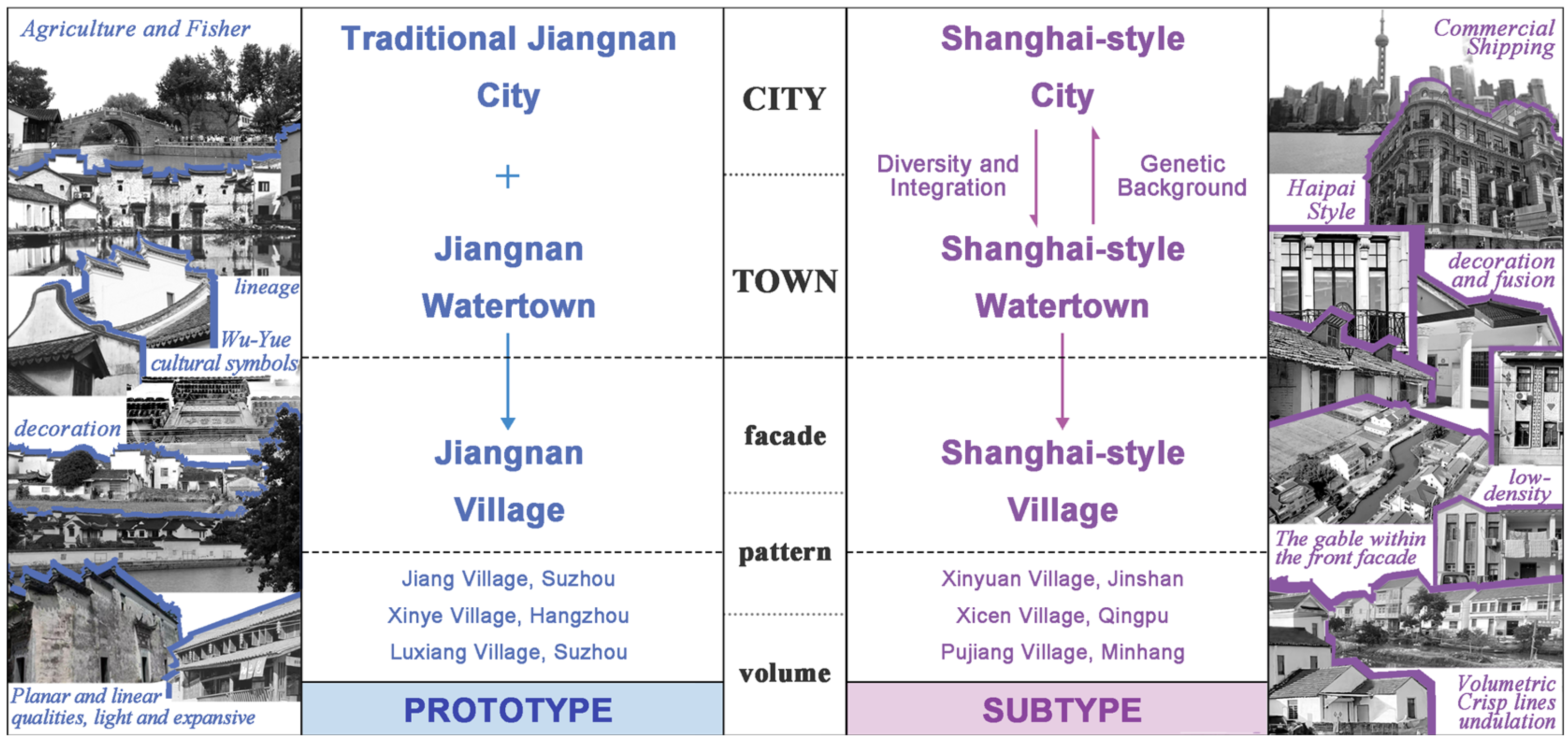
In the regional context of the integration of the Yangtze River Delta, “Shanghai-style Jiangnan” exhibits a unique settlement landscape resulting from the intersection of traditional Chinese agrarian civilization and modern urban industrial civilization. Distinct from the closed and introverted nature of traditional Suzhou and Hangzhou water towns, “Shanghai-style Jiangnan” leverages Shanghai’s geographical advantage at the confluence of rivers and the sea to form an open water and land network. It retains both the water town characteristic of “houses following the river” and the scattered village pattern of “streams following the houses” [10], forming a unique ternary spatial structure of “water-field-village.” After Shanghai opened its port in 1843, the “Bund-Shiliupu (Sixteen Pu)” river–sea combined transport hub model emerged, connecting to global trade externally and linking hinterland shops internally, thereby driving the integration of local and foreign cultures [11]. Eclectic styles of Western architecture (such as facade compositions, structural decorations, and spatial combination modes) penetrated the rural hinterland. Based on the inheritance of the traditional Jiangnan courtyard typology, Shanghai-style vernacular dwellings broke away from a single linear layout, forming a three-dimensional, complex picture of Sino-Western fusion (Figure 1).
However, driven by rapid urbanization and the uncontrolled sprawl of metropolitan areas, this highly recognizable carrier of regional culture is facing a severe survival crisis. Due to insufficient protection of the ecological fabric and inadequate excavation of characteristic genes, the homogenization of Shanghai’s peri-urban villages has intensified, local features have dissipated, and urban characteristics have overly encroached. Therefore, systematically sorting out and quantifying the landscape characteristics of “Shanghai-style Jiangnan” is not only a key measure to resist the landscape homogenization of peri-urban villages but also provides a highly theoretically valuable Chinese paradigm for global cities on how to dynamically balance cultural heritage preservation and spatial renewal amidst rapid expansion.

1.2. Literature Review and Research Gap

1.2.1. Current Status of Research on Rural Renewal and Rural Landscape Genes

Rural renewal and landscape preservation are common topics for global sustainable rural development. Based on different national conditions and regional characteristics, various countries have formed distinct research systems and practical paths. Overall, it exhibits the key characteristics of a shift from a focus on single-function production towards multi-dimensional system integration and from static material restoration towards dynamic sustainable development. This section systematically sorts out relevant research progress from three dimensions: the theoretical context of global rural sustainable development, the local practice guided by China’s ecological civilization construction, and the core theoretical system of rural landscape genes.
  • The Evolution of Rural Sustainable Development and Multi-dimensional Renewal Practices from an International Perspective
In international research, rural landscape is often intertwined with concepts such as rural features and rural characteristics. Its theoretical evolution is deeply bound to the iteration of the global rural sustainable development paradigm, which has gone through three core stages as a whole. The first stage is the productivism-led stage from the 1950s to the 1980s, the core of the research focused on maximizing the agricultural production function of rural areas, with economic output as the core evaluation standard. Rural landscape and material space were only regarded as subsidiary carriers of agricultural production, and relevant policies and research were carried out around land consolidation and agricultural efficiency improvement [12,13]. The second stage is the post-productivism transformation stage from the 1990s to the early 21st century. The rural policies of Western countries have transitioned from an early focus on agricultural production to an emphasis on natural ecology, cultural landscape restoration, and multi-functional integration. With the emergence of “urban diseases” and the popularization of sustainability concepts, Western rural policies and research priorities gradually shifted from agricultural production towards agricultural resource protection, cultural landscape restoration, and the multifunctional development of rural areas. The ecological, cultural heritage, and recreational values of the rural landscape have come under systematic scrutiny. Rural regeneration has entered a new renewal phase characterized by “hybridity” under globalization [14,15]. The third stage is the in-depth development stage of rural resilience and sustainable development from 2010 to the present. Research regards rural areas as a complex adaptive system combining nature, economy, and society, with a core focus on the multi-dimensional resilience improvement of rural areas under the impact of urbanization [16,17,18], and emphasizes the in-depth integration of rural landscape protection with the coordinated development of ecology, society, and culture, which has become the core framework of current international rural research.
Different countries promote their distinct approaches to rural renewal based on varying regulations and policies (Table 1). Relying on vast rural spaces and lower population and building densities, a research orientation emphasizing ecological protection, heritage value, and multi-stakeholder participation has been formed [19,20]. Germany, supported by Flurbereinigungbetreffe (the Land Consolidation Act) as the core institutional system, has established the concept of “integrated renewal”, which deeply integrates the spatial form control of rural areas, ecological environment improvement, and agricultural structure optimization and constructs a planning framework for the coordination of multiple stakeholders [21,22]. The UK highlights the public attribute of rural landscape resources, clarifies the leisure value and ecological protection bottom line of the rural environment through the National Parks and Access to the Countryside Act 1949, and forms a multi-stakeholder renewal model led by the government with the in-depth participation of non-governmental organizations (NGOs) [23,24]. Italy adopts a multi-stakeholder collaborative renewal model, which expands the protection perspective of rural landscape from individual historical buildings to the overall built environment, and allows moderate functional activation and spatial renewal on the premise of strictly preserving the core value of heritage [25]. Japan has narrowed the urban–rural gap through the “Village Building Movement”, and after the 21st century, based on the “original landscape” theory, it has stimulated the endogenous vitality of rural areas and local cultural identity through the flexible intervention of art and culture, forming a characteristic path of culture-enabled rural landscape protection [26,27]. Overall, international research and practice in rural renewal have consistently centered on the core objectives of sustainable development, emphasizing the social and cultural dimensions of rural landscapes, highlighting ecological resilience, establishing multi-stakeholder consultation mechanisms, and the living preservation of historical heritage [28]. The relevant practical models and theoretical findings provide valuable references for research on rural regeneration in China.
2.
Practices in Building an Ecological Civilization and Preserving Rural Heritage from a Chinese Perspective
The research and practice of rural landscape in China have always been deeply bound to local policies. Ecological civilization construction constitutes the core local paradigm of China’s rural sustainable development, which has formed in-depth dialogue and local innovation with the global rural sustainable development paradigm. Since the advancement of ecological civilization was incorporated into the “Five-Sphere Integrated Development” framework in 2012, rural areas have become the focal point of ecological civilization efforts [29]. Following the full implementation of the Rural Revitalization Strategy in 2018, the overarching requirements of “ecological livability, civilized rural customs, and effective governance” [30] have further driven research on rural landscapes to shift from a narrow focus on physical spatial transformation toward the coordinated optimization of the “Production-Living-Ecological” spaces [31,32] and the systematic preservation of local cultural heritage.
Existing research has formed a multi-perspective and multi-level systematic framework, encompassing spatial texture maintenance [33] and micro-intervention planning [34] from a micro perspective, cultural inheritance and spatial narratives [35] from a meso perspective, and Landscape Character Assessment (LCA) [36] and urban weaving theory [37] from a macro perspective for landscape construction and renewal strategies. In terms of rural construction practice, relevant research has yielded a wealth of findings on indigenous construction methods, identifying three local design models: green construction, localized community building, and circular construction [38]. In response to the needs of low-carbon development in rural areas, design strategies for implementing spatial and technical prototypes have been explored [39]. Based on the theory of metabolism, multivariate dynamic adaptation design paths have been to accommodate the dynamic development of rural communities [40].
Overall, domestic research on rural landscape preservation and renewal generally starts from material and non-material conditions, focuses on specific regional issues, uses theoretical perspectives to guide strategy construction, and shows an evolutionary trend from static description to dynamic mechanisms, from single elements to system integration, and from physical space to “social-cultural-ecological” multi-dimensional coupling. However, to translate the combination of cultural inheritance and spatial carriers into practical operations, it is necessary to conduct systematic and in-depth research on the internal composition and organization of rural landscapes through the theoretical perspective and analytical framework of “rural landscape genes.”
From the perspective of global academic dialogue, China’s rural development paradigm—centered on ecological civilization—has reached a core consensus with international paradigms of sustainable rural development: both have moved beyond a narrow economic dimension of rural development cognition and emphasized the coordinated development of rural natural, economic, social and cultural systems. The core difference between the two is that the international sustainable development paradigm pays more attention to the bottom-up game and practical innovation of multiple subjects, while China’s ecological civilization construction paradigm highlights the in-depth integration of top-level design with regional cultural context and ecological base, forming a theoretical framework of rural development with unique Chinese characteristics and also providing a clear local practice orientation for the research on rural landscape genes.
3.
Application and Expansion of Rural Landscape Gene Theory
Research on rural landscape genes forms the critical link between landscape theory and planning practice. At its core, this research introduces the biological concept of genes into the study of rural landscapes. By identifying and extracting core elements within rural landscapes that embody regional distinctiveness and cultural heritage, it decodes the intrinsic “genetic code” of rural character, thereby providing a scientific basis for the systematic conservation and renewal of rural landscapes. The early metaphor of “landscape genes” revealed the cultural codes and genetic information embedded in landscape patterns [41], with later work refining the concept of the Cultural Landscape Gene of Traditional Settlements (CLGTS), focused on the core characteristics and unique elements of settlement landscapes that are inheritable and replicable [42]. By integrating external physical genes and internal cultural genes, CLGTS documents the natural laws, social relations, and cultural meanings of settlement landscapes [43] and has become a foundational reference for research on cultural landscape evolution [44].
Existing studies on the identification, extraction, and application of rural landscape genes has developed two relatively independent theoretical branches to promote the extraction of settlement spatial elements, morphological evolution mechanisms, and preservation strategies [45,46], which are “landscape gene” theory and “spatial gene” theory. For landscape gene research, rooted in geographical science [47,48], scholars have built multi-dimensional analytical frameworks by integrating architectural, ecological, humanistic, and economic gene categories [49]. Most studies in this field focus on the vertical hierarchical decoding of landscape elements, organizing gene elements through mature frameworks including the “phenotype-coding-modification” logic [50], the “point-line-network-volume” hierarchy [49], and the “cell-chain-shape” structure [51]. This body of work has been widely applied to specific geographic contexts [52] and settlement typologies [48,53,54], with a growing focus on visualizing the gene atlas of the research objects [55]. In parallel, spatial gene theory, extended from urban to rural areas, focuses more on the horizontal topological correlation and interaction mechanism between spatial elements. Existing studies in this field have mainly explored quantitative coding methods [56] and gene pool construction [57] to support rural design practice, with an emphasis on the structural association between elements rather than the vertical identification of individual features.
However, the current research on rural landscape genes still has a systematic lack of materiality perspective. Most existing studies generally regard the material space of rural landscape as a passive carrier of cultural connotation, focusing on the identification, coding, and classification of gene elements, but ignoring the agency of material space itself and the symbiotic and co-productive relationship between material space and human society [58], which also leads to the disconnection between the protection and renewal strategies of landscape genes and the inheritance of local culture and the reshaping of community identity. The new materialism emerging in the field of human geography proposes that the key to transforming rural materiality from a passive background of social change to an active analytical core is to break the shackles of anthropocentrism and eliminate the binary opposition between nature/society and subject/object [59]; its constructed three-level model of rural materiality (surface matter—materiality of artefacts—experimental materiality) [58] further points out that core material carriers such as rural houses and public spaces are the core fields of hybrid integration and the co-production of human and material, and their spatial renewal process is directly related to the inheritance of rural collective memory and the reshaping of local identity. This theory provides an important supplement for the research on rural landscape genes, promoting the research to extend from element identification to the systematic protection of human–land symbiosis, and also provides theoretical support for the combination of rural landscape renewal strategies and the inheritance of local spirit.

1.2.2. Limitations of Existing Research

Current research has achieved fruitful results in the fields of rural preservation, renewal, and landscape genes and is evolving towards systemic integration and multi-dimensional coupling. However, facing the complex urban–rural gaming and spatial reconstruction of peri-urban villages in megacities, especially the special development context of “Shanghai-style Jiangnan” water town villages, existing research still has the following significant limitations in its theoretical framework and practical application:
  • The Systemic Disconnect between Vertical Identification and Horizontal Coupling
Most existing landscape gene research prioritizes the vertical hierarchical identification of individual elements, focusing on the qualitative extraction of architectural symbols, planar shapes, or isolated ecological patches, while neglecting the horizontal topological relationships between multiple landscape elements. This core oversight means existing studies cannot systematically decode the figure-ground nesting and spatial coupling relationships among water systems, farmlands, roads, and vernacular dwellings, which directly leads to blind and unsubstantiated boundary delineation in rural planning, failing to accurately distinguish high-value heritage areas from adaptable renewal spaces.
Further, existing studies have largely applied landscape gene theory, spatial gene theory, and figure-ground relationship theory in separate contexts, without integrating them into a unified, procedural analytical framework, and even lack attention to the agency of material space from the perspective of new materialism, making it difficult to realize the effective transformation from macro planning principles to micro quantifiable governance strategies. This study seeks to address this gap by integrating these three theories into an adaptive zoning tool based on bidirectional coupling. This tool can explicitly quantify the spatial renewal tolerance of different zones and translates macro planning principles into precise, quantifiable governance strategies.
2.
Dynamic Reconstruction of Genius Loci and Rural Identity Lacks Scientific Support
One of the core demands of rural renewal is the continuation of the “Genius Loci” [60]. Existing landscape preservation often treats the countryside as a static exhibit, focusing on the restoration of the physical environment while neglecting the dynamic evolutionary characteristics of rural spaces. For villages like “Shanghai-style Jiangnan,” the local spirit is not attached to individual historical buildings, but is rooted in the long-term organic nesting relationship of “water-field-village” and the continuity of villagers’ lives. Under the dual background of urbanization impact and socio-economic transformation, existing research has developed neither quantifiable evaluation methods nor systematic theoretical frameworks to address the central question of “how to dynamically reconstruct and maintain this deep-rooted cultural identity while introducing modern lifestyles and replacing spatial functions”, nor has it established a scientific causal relationship between the renewal of physical spaces and the enhancement of community resilience.
3.
Limitations to the Research Perspective on the Regional Characteristics of “Shanghai-style Jiangnan”
Current research targeting the unique regional settlement of “Shanghai-style Jiangnan” mostly remains at the surface improvement level of physical spaces [5]. Existing strategies mostly focus on ecological baseline governance, classification of the settlement morphology, and the physical transformation of vernacular architecture. While these studies provide references for landscape enhancement, they lack a deep discussion on the dialectical relationship between preservation and renewal and also fail to deeply integrate the global rural sustainable development paradigm with the local requirements of China’s ecological civilization construction to build a systematic analytical framework adapted to the regional characteristics of “Shanghai-style Jiangnan”. This study attempts to break through this perspective limitation by constructing a bidirectional gene network, combining multi-dimensional analysis of social-cultural-physical aspects and multi-scale mapping of ecology–settlement–architecture, and proposing a quantifiable morphological analysis path, thereby establishing an adaptive control system that balances urbanization tension and landscape gene inheritance, and provides scientific support for the sustainable development of “Shanghai-style Jiangnan” rural areas.

1.3. Research Questions and Hypotheses

Drawing directly on the research gaps outlined above, this study addresses three interrelated, unanswered research questions at the core of “Shanghai-style Jiangnan” rural renewal:
First, to address the overreliance on single-element vertical identification and the neglect of horizontal topological coupling in existing research, how can we construct a bidirectional gene-atlas network model that integrates vertical hierarchical decoding and horizontal topological coupling, tailored to the unique spatial characteristics of “Shanghai-style Jiangnan” villages?
Second, how can we establish a quantitative morphological analysis framework to accurately evaluate the value of rural landscape genes and scientifically delineate the spatial boundaries between heritage preservation and functional renewal, to overcome the one-size-fits-all limitations of traditional rural planning?
Third, based on the results of gene identification and quantitative evaluation, how can we formulate a differentiated spatial governance strategy for “Shanghai-style Jiangnan” villages that achieves a dynamic balance between landscape heritage protection and modern functional adaptation?
Corresponding to these research questions, we propose three testable hypotheses to be validated through an empirical analysis of Xinyuan Village:
H1. 
A bidirectional gene-atlas network integrating the vertical hierarchy of landscape genes and the horizontal topological correlation of spatial genes can decode the landscape characteristics of “Shanghai-style Jiangnan” villages more systematically and comprehensively than existing single-dimensional identification frameworks.
H2. 
A quantitative evaluation framework combining the Entropy Weight Method and Kernel Density Analysis can accurately identify the spatial differentiation of rural landscape value, clarify the boundary between preservation and renewal, and resolve the core problem of vague protection boundaries in traditional planning.
H3. 
Based on the results of quantitative assessments, implementing tiered and differentiated management strategies can effectively balance the needs for landscape conservation and functional renewal in “Shanghai-style Jiangnan” villages, while enhancing the adaptability and resilience of rural spaces.

2. Materials and Methods

2.1. Study Area: Xinyuan Village

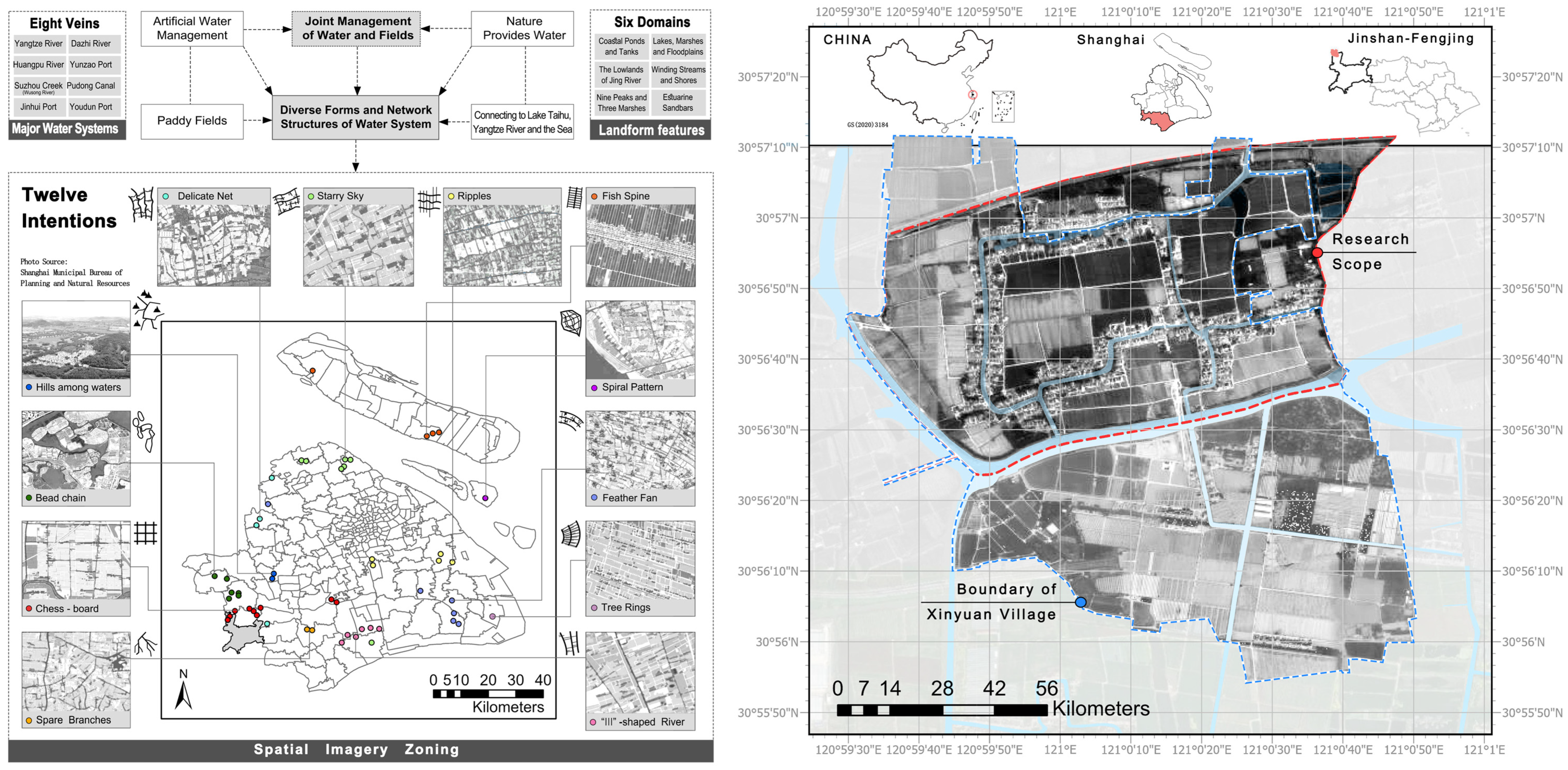
As the first pilot unit of Shanghai’s “Shanghai-style Jiangnan” characteristic village landscape preservation and inheritance planning project, Xinyuan Village is located in the lowest-lying area of Jinshan District near Shanghai’s ancient coastline, the “Gangshen Line.” It belongs to the unique “Lowland of Jing River” geomorphology among the “Six Domains” of Shanghai’s rural landscape spatial structure (Figure 2). It exceptionally preserves a complete “figure-eight (θ-shaped)” water network and a “polder field” system, tracing back to the traditional rice-farming space of “chessboard polders” in ancient Jiangnan agricultural production through its unique grid water network. It is a “very precious living specimen left over from the agrarian era” [61]. Coupled with the landscape island feature formed by long-term traffic isolation, Xinyuan Village has become an excellent sample for studying how original rural genes resist urbanization interference. Therefore, this study takes Xinyuan Village as the research object, utilizes theories such as the figure-ground relationship, spatial genes, and space syntax, and adopts field investigation and typological methods to identify and extract the Xinyuan spatial genome. Based on “gene factors-gene chains-gene sequences”, a bidirectional research model of “Point-Line-Network-Surface” is built to construct the Xinyuan gene atlas network, graphically represent the Xinyuan landscape gene pool, and provide references for the preservation and renewal practices of characteristic villages in Shanghai under the context of “Shanghai-style Jiangnan.”
Xinyuan Village is located at the northernmost part of Fengjing Town, Jinshan District, Shanghai, and has been a naturally formed rural settlement since ancient times. During the Ming Dynasty, the excavation of the Fanjiabang in southern Shanghai connected it to the Huangpu River, replacing the middle and lower reaches of the Wusong River and becoming the main water outlet channel for the eastern part of Lake Tai. The Huangpu River experiences alternating tides; during high tide, the water level is higher than the fields, and vice versa. During the flood season, the water discharging from the upper reaches of Lake Tai, superimposed with the Yangtze River flood, forms a sustained high-water level, and the low-lying fields frequently suffer from waterlogging due to blocked natural drainage. To mitigate the impact of natural disasters on daily life, straight canals were reinforced within the village to enhance gravity drainage and water circulation; engineering works such as excavating rivers, building banks, and installing sluice gates directly shaped the layout of the settlement, ultimately forming a chessboard-like rural fabric intertwined with the “Small Paddy Field of Dangtian” and the “Large Paddy Field of Tangpu” [61].
Xinyuan Village covers an area of 3.78 square kilometers, comprising five natural hamlets with a current population of about 1100. It retains historical remnants including 13 rivers, 16 ancient bridges, and the 150-year-old Luoqiang House [61]. The interior of the village preserves a complete chessboard river system and traditional reclaimed lands. Its spatial fabric has been verified as a rare remnant of the Large Paddy Field of the Tangpu system from the late Tang Dynasty in Shanghai. Various natural and cultural landscapes within Xinyuan Village organically form a whole: the water network crisscrosses in longitude and latitude with main flows almost parallel; ecological lands such as forests and farmlands are separated into grids by waterways and roads; and vernacular buildings are distributed in a ring shape along the water, forming a highly recognizable “vibrant water ring” fabric. Water, forest, field, road, and architecture collectively constitute the unique village landscape of Xinyuan.
As a typical sample of traditional agrarian civilization, Xinyuan Village epitomizes the evolutionary trajectory of “Shanghai-style Jiangnan” throughout eras of change. In the 1980s and 1990s, driven by national rural infrastructure construction policies, rural renewal focused on traffic accessibility and housing safety, with meeting basic living needs as the core [62]. At the beginning of the 21st century, responding to national strategies and local policies such as “Beautiful Countryside” and “Rural Living Environment Improvement,” measures like centralized residence, environmental optimization, and ecological governance were promoted. A village-wide governance system was established, synchronously retaining the original rural landscape [63]. After 2020, to implement key tasks of rural revitalization, efforts focused on upgrading agricultural infrastructure and consolidating the ecological environment, while unearthing cultural resources like ancient bridges and old houses to lay the groundwork for industrial transformation [64]. These three renewal stages deeply reflect the cyclical game of spatial renewal, heritage preservation, and cultural inheritance in the peri-urban villages of China’s megacities.

2.2. Research Methods

2.2.1. The Bidirectional Gene-Atlas Network Model

For complex adaptive systems like rural settlement spaces, the study should integrate the landscape gene theory [49] that emphasize the integrity of vertical hierarchical elements and the spatial genes theory [65], which focus on the horizontal topological connections of spatial morphology. From both vertical and horizontal dimensions, a bidirectional gene network model should be established to address the limitation of existing studies that prioritize the deconstruction of single elements over the systematic correlation of multiple elements.
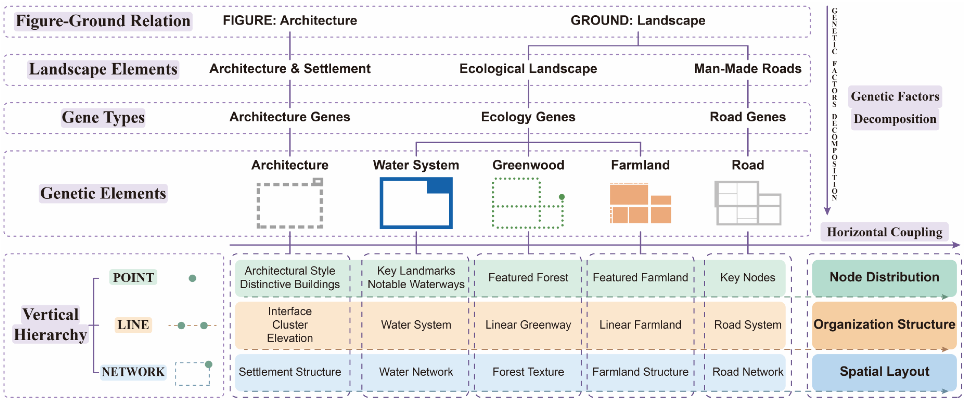
The overall pattern of Shanghai-style Jiangnan has gradually evolved through the dual effects of natural landscapes and human construction [8]. Therefore, based on the “figure-ground relationship” theory, architecture serves as the “figure,” corresponding to architectural operations and settlement fabric and classified as the architecture gene type; the landscape serves as the “ground,” corresponding to the ecological baseline and road system and divided into two major gene types, which are ecology gene and road gene. The three gene types are further decomposed into five major gene elements: architecture, water system, greenwood, farmland, and road. The figure–ground relationship carries the intrinsic correlation between elements and the overall landscape presentation, thus focusing the research on the analysis of hierarchical characteristics and coupling relationships of the five elements.
This study takes the growth pattern and sequential structure of “from point to line to surface” of Jiangnan water town settlements as the theoretical basis for vertical analysis [66] and constructs a vertical hierarchical decoding framework of “point-line-network”. Among them, point gene refers to the nodes with turning, mutation, or special symbolic significance in linear elements, which is the concentrated embodiment of non-linear and inhomogeneous characteristics in the linear sequence; line gene is the continuous segment defined by the point genes at both ends, which constitutes the branch unit of the overall skeleton of the “network gene”; network gene is the overall network structure formed by the interweaving of multiple line genes. Through the step-by-step deconstruction and integration of “point-line-network”, the full-level landscape information of a single element is completely carried.
Meanwhile, this study takes the analytical principle of group structure as the theoretical support for horizontal coupling and regards the multi-element system of Shanghai-style Jiangnan villages as a connectivity-based topological network [67] (pp. 18; 55–56). Among them, the “point” is not only the medium for the correlation of elements at the same level, but also the connection hub for the superposition of different elements [67] (p. 36). Based on the three modes of group structure, chain subgroup, parallel subgroup, and hierarchical subgroup [67] (pp. 19–36), a multi-element horizontal coupling mechanism is constructed: the coupling correlation of point genes corresponds to the chain subgroup mode, focusing on the node space of element connection and transformation; the coupling correlation of line genes corresponds to the parallel subgroup mode, presenting the linear texture formed by the parallel juxtaposition of multiple elements along the axis; the coupling correlation of network genes corresponds to the hierarchical subgroup mode, analyzing the overall network system formed by the step-by-step integration of multiple elements.
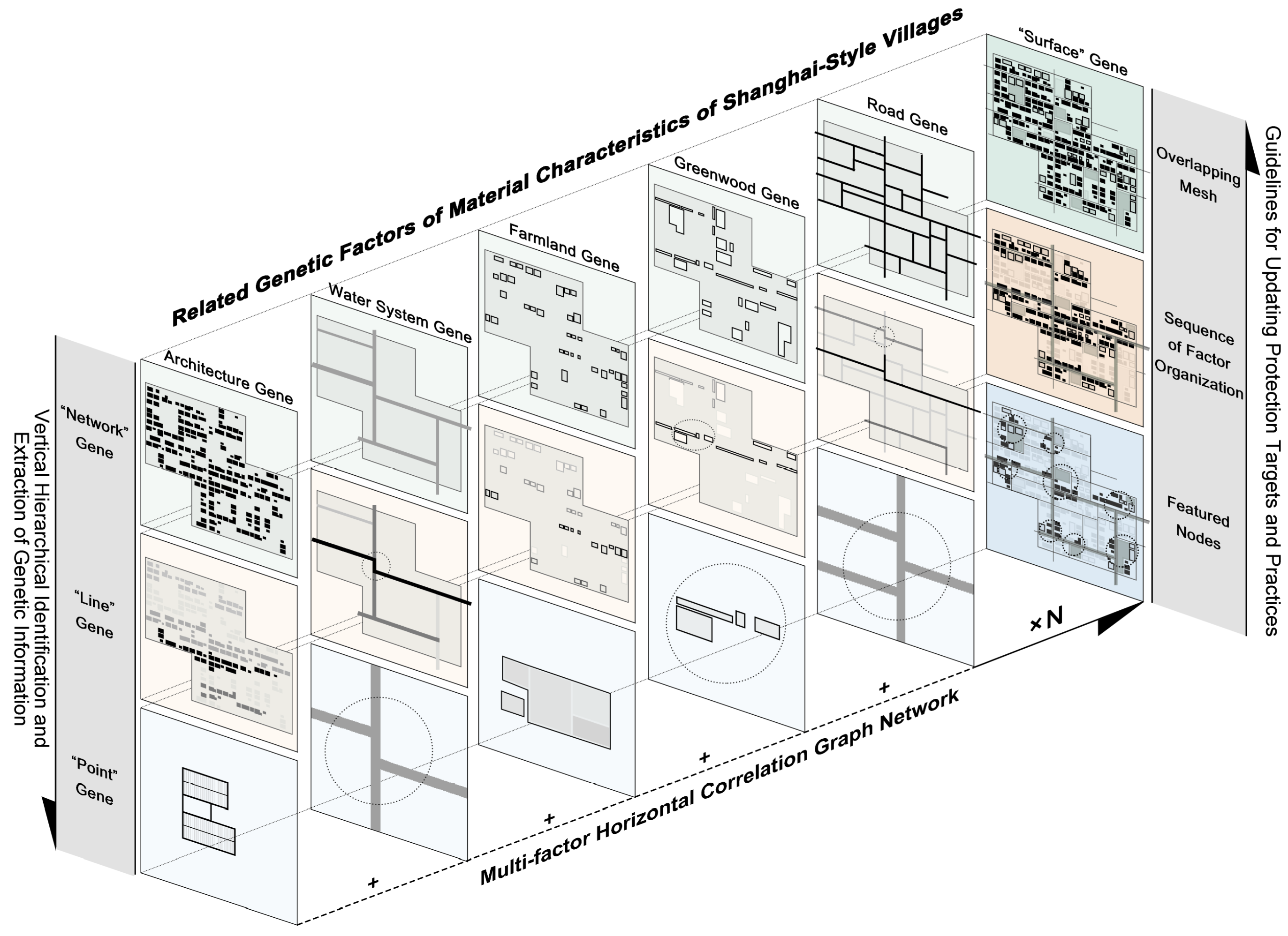
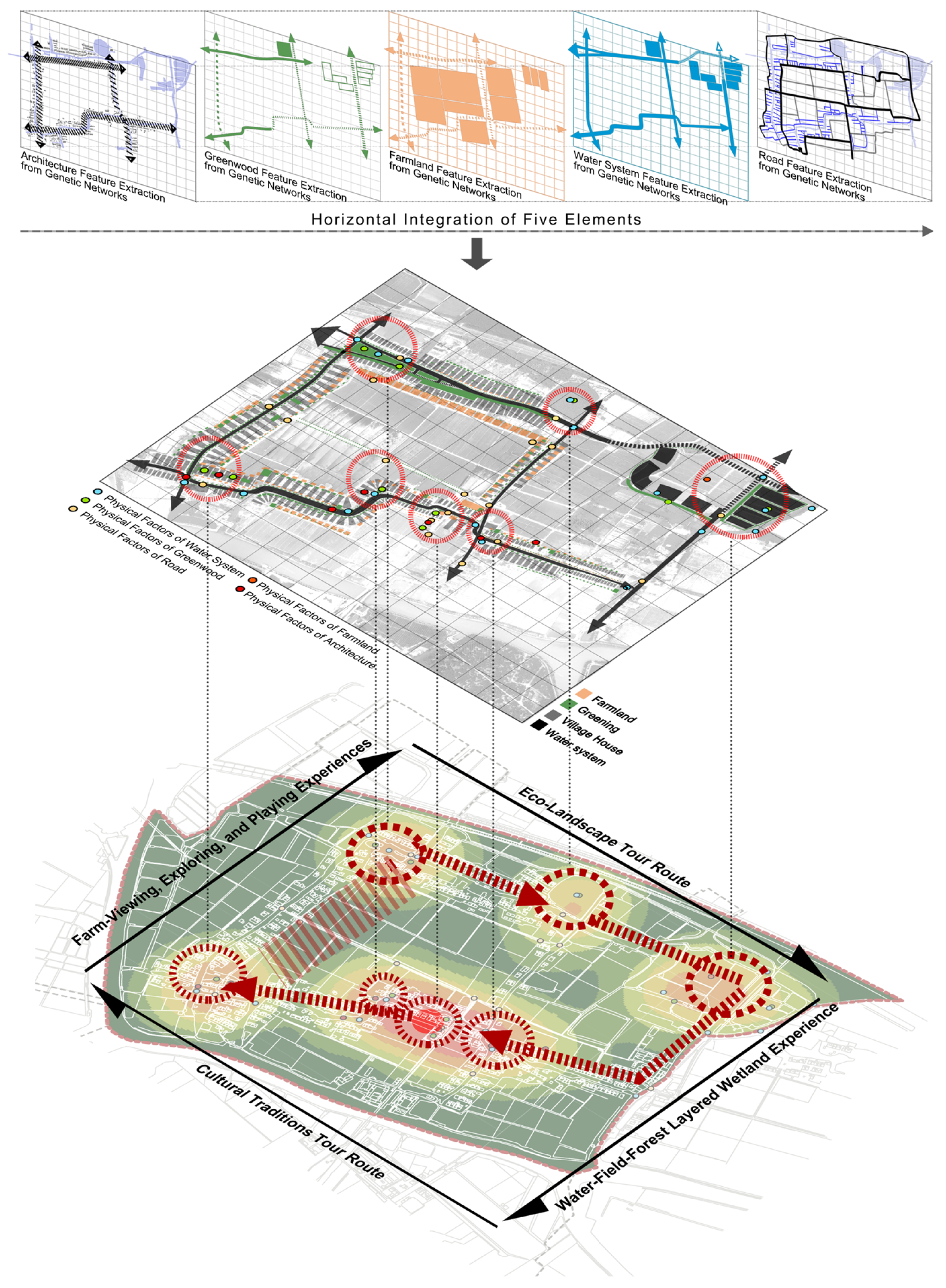
The overall landscape of the village is a structural group formed by the combination of the three structural modes of “hierarchical subgroup + parallel subgroup + chain sub-group” [67] (pp. 37–38), which is finally presented as the overall landscape characteristics on the areal scale. On this basis, this study constructs a complete analytical framework of “point-line-network-surface”, namely the bidirectional gene-atlas network with vertical hierarchy and horizontal coupling (Figure 3). Vertically, each element is deconstructed into hierarchical levels; horizontally, the coupling correlation of multiple elements is completed at each level. Point genes aggregate to form characteristic nodes, line genes splice to form element organizational sequences, and network genes overlap to form the spatial pattern of the overall surface area. Based on this, a bidirectional gene atlas network is built to identify nodes, interfaces, and areas with special value within the overall framework of the village; locate spatial units targeted for renewal and transformation; organize spatial narratives; and provide guidance for the entire process of rural preservation and renewal planning and design.

2.2.2. Qualitative Screening of Evaluation Subjects and Quantitative Measurement of Evaluation Indicators

To objectively quantify the impact of characteristic rural landscape elements and accurately identify the importance levels of landscape nodes, this study follows a core principle of “qualitative screening first, quantitative calculation second.” Through the qualitative screening of characteristic factors and evaluation indicators, the boundary is defined for subsequent quantitative analysis, and the deviation of subjective judgment is limited through clear and traceable screening criteria.
The construction of the indicator system starts from the vertical dimension of the bi-directional gene network. Point gene focuses on monomer characteristics, with two indicators of “feature rarity” and “type rarity” set to measure the uniqueness and rarity of the monomer; line gene reflects the interface characteristics between elements, with two indicators of “visual openness” and “interface connection types” set to measure the correlation between the factor and surrounding elements as well as spatial quality; network gene corresponds to structural characteristics, with indicator settings referring to the “connectivity” in space syntax [68] and the “local visual clustering coefficient” in graph theory [69], and two indicators of “node degree” and “clustering coefficient” set to measure the importance of the monomer in the overall spatial network through correlation density and agglomeration. The indicator system and calculation methods are shown in Table 2.
Based on the identification results of gene elements such as architecture, ecology, and roads, representative entities such as historical buildings, characteristic water systems, and public spaces are extracted as evaluation objects. The characteristic entity factors must meet the following criteria: they belong to the gene types defined by the bidirectional gene model and are the core entity elements constituting the village landscape; have clear landscape representativeness, historical and cultural value, or spatial structural importance; can be quantitatively measured through spatial data and field research; meanwhile, elements that are completely damaged or have no conservation and renewal value are excluded.

2.2.3. Weight Calculation and Comprehensive Score Based on Entropy Weight Method

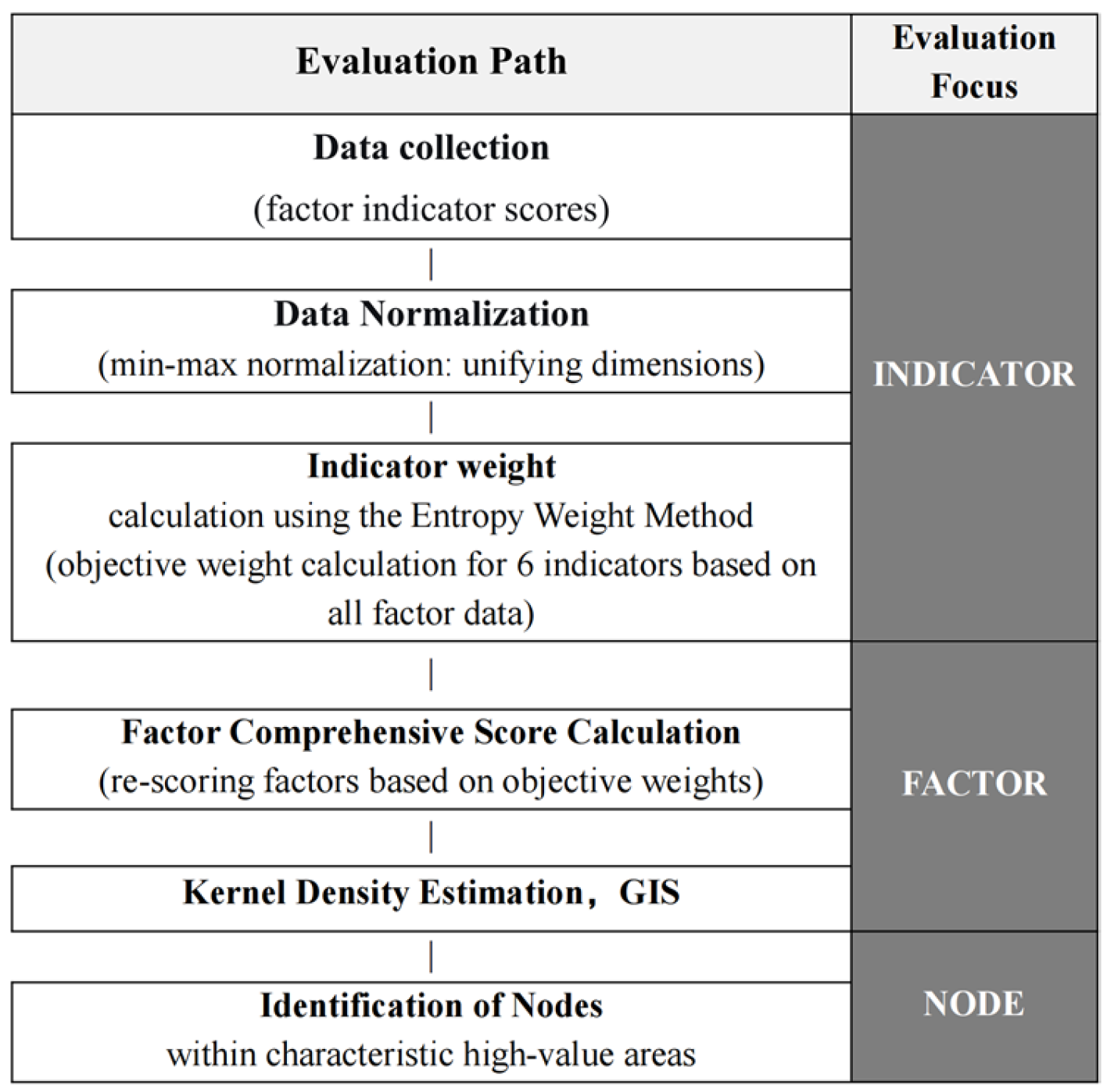
Shanghai-style Jiangnan villages are an organic entirety with multi-element coupling, and their systematic characteristics are highly isomorphic with ecosystems. This study migrates and applies the multi-level and multi-indicator comprehensive evaluation theory and methods for a biodiversity conservation and ecosystem integrity assessment in the field of ecology [72,73,74,75] to the rural landscape value evaluation scenario and integrates the phased evaluation idea of traditional village landscape [76], to construct a three-level rural landscape evaluation system of “indicator-factor-node” (Figure 4). Through this system, the core quantitative path of “indicator standardization—objective weighting by EWM—comprehensive value scoring of factors” can be formed. Then, the hotspot distributions can be identified through GIS Kernel Density Estimation (KDE) kernel to avoid the deviation of subjective weighting. Finally, combined with ArcGIS Pro 3.1.5 spatial analysis tools, a quantitative evaluation system for characteristic elements is constructed, providing a scientific basis for prioritizing preservation and renewal in Xinyuan Village and making site-selection decisions.
In this stage, the Entropy Weight Method is used to determine indicator weights and calculate the comprehensive score. The information entropy reflects the dispersion degree of the indicator, objectively avoiding subjective weighting bias [77]. The specific calculation steps are as follows:
  • Min–Max Normalization (Formulas (1) and (2))
The indicator data is standardized to eliminate dimensional effects, the information entropy and weight values of each indicator are calculated, and finally, the comprehensive score of each characteristic factor is obtained through weighted summation to quantify its contribution to the village landscape.
For the original data ( x j ) of the six indicators in Section 2.2.2, Min–Max normalization is used to eliminate the differences in dimension and order of magnitude of different indicators, so that indicators of different dimensions are horizontally comparable:
x i j = x i j min ( x j ) m a x ( x j ) m i n ( x j )
where  m i n ( x j )  and  m a x ( x j )  are the minimum and maximum values of the j-th indicator among all factors, respectively;   x i j  is the Min–Max normalization value of the i-th factor on the j-th indicator (ranging from 0–1).
If  x i j 0 , non-negative translation is performed:
x i j = ( x i j ) + 0.01   i , j
2.
Calculation of Indicator Weights in Global Evaluation (Formulas (3)–(6))
Use EWM to calculate the proportion  p i j  of the i-th factor under the j-th indicator, to convert the standardized values into proportional form for subsequent entropy calculation:
p i j = x i j i = 1 n x i j
where  x i j  is the non-negative translation value of the i-th factor on the j-th indicator, and n is the total number of characteristic factors.
Calculate the entropy value  e j  of the j-th indicator, to reflect the information content of the indicator through the entropy value. The smaller the entropy value, the higher the dispersion of the indicator data and the more effective information it contains:
E j = 1 ln n i = 1 n p i j ln ( p i j )
Calculate the variation coefficient  d j  of the j-th indicator, to inversely quantify the effective information contribution of the indicator. The larger the difference coefficient, the higher the contribution of the indicator to the landscape value evaluation:
d j = 1 E j
Calculate the final weight  w j  of the j-th indicator, to standardize the difference coefficient into a weight value in the range of 0–1 and complete objective weighting:
w j = d j j = 1 m d j
where  m  is the total number of evaluation indicators ( m = 6  in this study).
3.
Calculation of Comprehensive Score of Factors under Global Weights (Formula (7))
The weighted summation method is used to calculate the comprehensive value score  s i  of each characteristic factor, to integrate the evaluation results of the 6 indicators and obtain the final quantitative result of the landscape value of each characteristic factor:
s i = j = 1 m x i j × w j
where  s i  is the comprehensive value score of the i-th factor; and   w j  is the weight of the j-th indicator.

2.2.4. Kernel Density Analysis and Robustness Test

After obtaining the above data, the discrete characteristic factor scores are converted into a continuous value density surface based on Kernel Density Estimation (KDE), to intuitively quantify the spatial clustering effects of high-value factors, thereby providing support for the scientific screening of nodes for renewal.
To verify the internal robustness of the evaluation model, the Equal Weight Method was introduced as a control group to redraw the heatmap. By overlaying and comparing the spatial distributions of the two sets of heatmaps, the consistency of their topological evolution trends can be verified. If the two are basically consistent, it can be confirmed that the evaluation results possess strong stability in this case, therefore eliminating the subjective interference and systematic deviation caused by weight allocation. Compared to the Equal-Weight Method, the Entropy Weight Method further enhances the discriminatory power of key spatial dimensions through information entropy metrics, ensuring the specificity of decision-making.
It should be clearly stated that this robustness test is only an internal verification of this case, and the universality and external robustness of the model still need to be further verified through multi-case comparative studies of villages with different types and regional characteristics.

3. Results

3.1. Vertical Identification Results

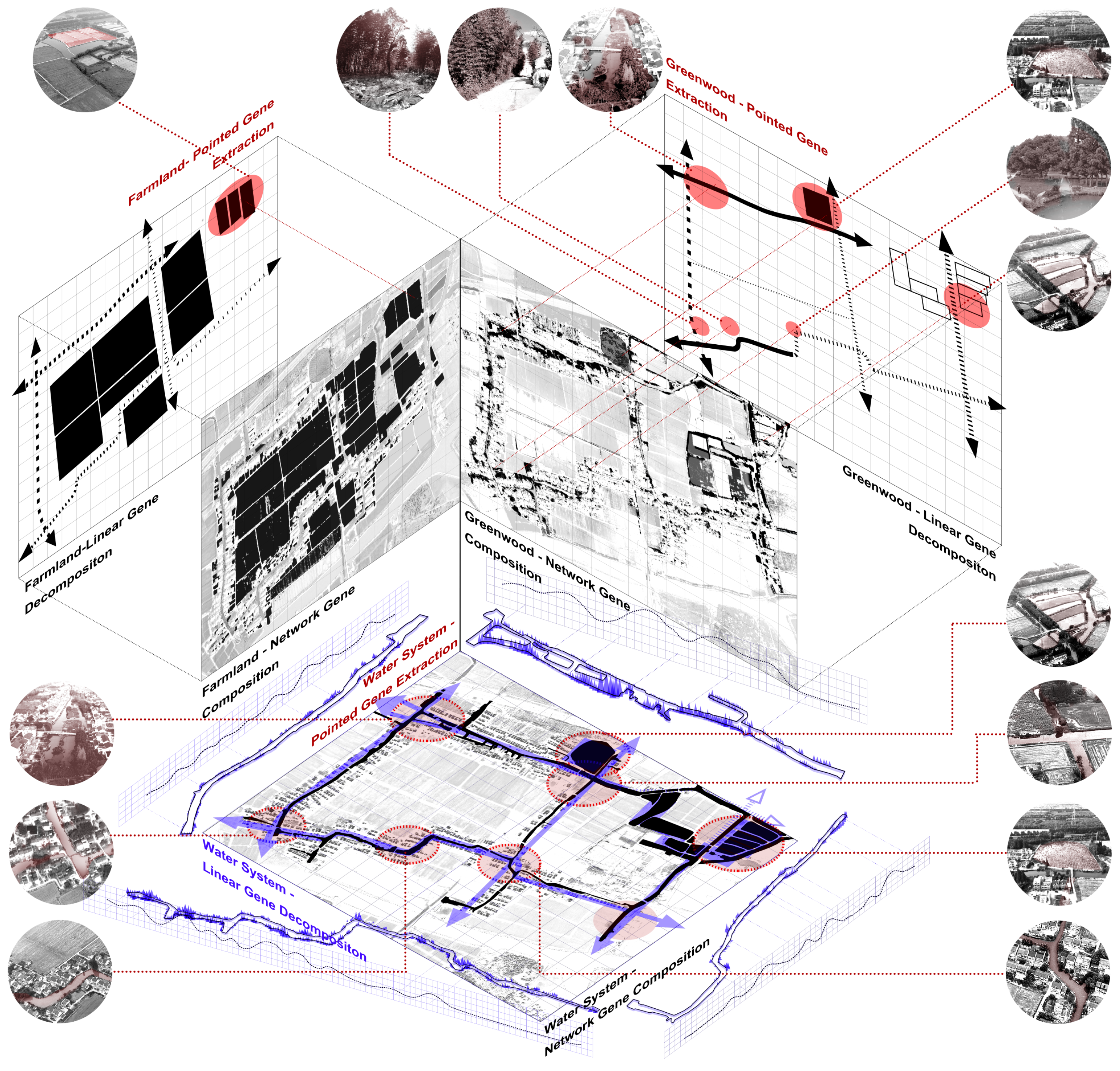
Vertical gene identification adopts a “Point-Line-Network” hierarchical framework, parsing hierarchically in the same space based on element attributes and planning goals. The hierarchies connect progressively to focus on landscape characteristics. Point genes anchor characteristic entity targets; line genes depict linear spatial characteristics and renewal potential; network genes coordinate the logic of the overall fabric layout. Ultimately, the model provides a prototype reference and design guidance for rural preservation and renewal. Based on the figure–ground relationship of each gene element in Xinyuan Village, they are analyzed across three categories: Figure-Architectural Gene, Ground-Ecological Gene, and Ground-Road Gene, to systematically decode the core landscape genes of Shanghai-style Jiangnan villages.

3.1.1. Figure: Architectural Gene

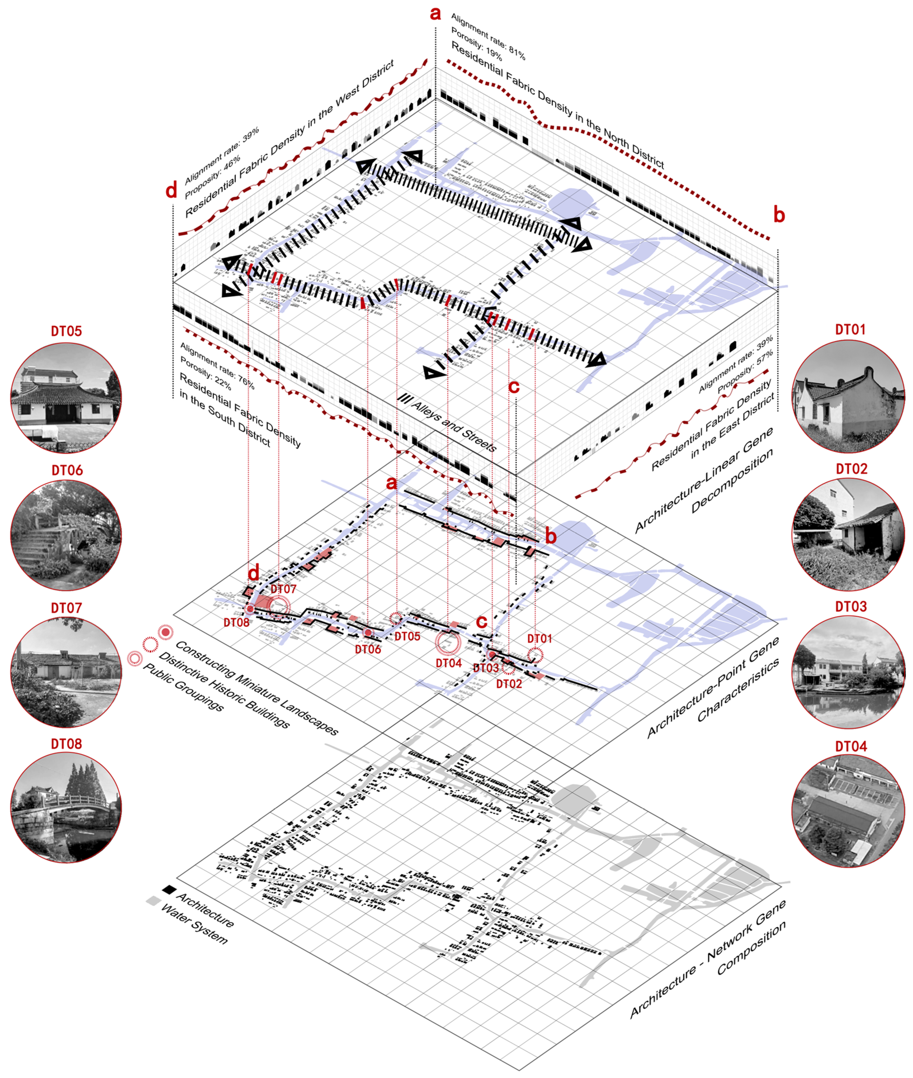
The vertical identification of architectural element genes systematically extracts Xinyuan Village’s landscape characteristics of “Sino-Western fusion and water-land coexistence,” covering three levels: overall settlement, linear blocks, and characteristic individual buildings (Figure 5).
Point genes are the most basic constituent units of architectural landscapes, including two cores: structural prototypes and characteristic single entities. The former extracts architectural prototypes based on plan, elevation, and roof forms: plans are divided into courtyard (square/O-shaped, U-shaped single-entry courtyards) and non-courtyard (centralized, I-shaped, L-shaped, C-shaped, concave-shaped) types; roofs are predominantly double-sloped gable roofs, retaining two characteristic roof forms: Luoqiang roofs (hip roof) and Guanyindou roof (Guanyin’s hat-shaped gable roof). The facades use different compositional methods paired with modern materials and decorative techniques to shape the “Shanghai-style Jiangnan” landscape. The latter filters characteristic historical single entities (like Guanyindou House and Luoqiang House), public clusters (comprehensive shop and village activity center), and historical structural ornaments (like Taiping Bridge) based on historical value, current conditions, and functional positioning, locking onto core nodes with renewal vitality and catalytic value.
Line genes take the four sections of core waterfront blocks around the village as objects of study, unfolding the block morphology and narrative from three dimensions: linear clusters, architectural interfaces, and continuous facades. Linear clusters analyze the spatial combination mode of blocks; buildings mostly adopt a juxtaposition mode parallel to the water system, forming a compact and continuous waterfront interface. The architectural interface controls the rhythm along streets and rivers. The identification finds that traditional segments (like South Street and North Street) have better interface permeability, forming a “water-road-house” spatial rhythm, while recently rebuilt segments show higher building density and stronger closure. Continuous facades show an evolutionary characteristic from the traditional Jiangnan tune of “white walls and dark tiles” to a “Shanghai-style hybrid” style featuring European-style decorations and ceramic tile veneers. This interweaving of old and new forms a unique linear landscape narrative.
Network genes focus on the overall fabric of the architectural settlement, identifying spatial morphology and layout patterns. The Xinyuan Village settlement exhibits a significant linear extension trend centered on the internal water system; streets and alleys are parallel to the water, and dual paths flank it. The village as a whole forms two types of settlement fabrics: “square/O-shaped” and “T-shaped,” reflecting traditional Jiangnan water towns’ reliance on water resources and the regular spatial baseline shaped by the grid water network. The building clusters unfold north–south or east–west along the water veins, forming an overall spatial pattern of “houses adjoining water, fields, and villages interwoven.”

3.1.2. Ground: Ecological Gene

The vertical identification of ecological genes follows the generative logic of “shaping by water, forming networks by fields.” The entire mechanism shapes the base using the water system skeleton, interlocking farmland through irrigation and water transport functions and coordinating greenery to weave the village boundary, jointly shaping the water-field-forest coupled baseline unique to Xinyuan Village as a “Lowland of Jing River” village (Figure 6).
Point genes accurately position key nodes for landscape enhancement by identifying mutation points and characteristic entities in the ecological baseline. Water system nodes focus on intersections, turns, and morphological mutations of water bodies, such as the island water bay on the northwest, the square lotus pond at the northern end of the middle road, and the well-preserved ecological fish pond on the east; these nodes all possess the potential to be transformed into waterfront spaces. In the farmland system, the polder remnants on the east side of the village act as important material catalysts reflecting the continuation of agrarian civilization. Greening nodes include the green island wetland on the northwest, bamboo patches on the southwest, and ancient village trees, etc. These “point” genes are critical nodes for ecological cycling and important carriers for the revitalization of future rural public spaces.
Line genes focus on the morphological changes and interface characteristics generated as ecological elements move through space. The water system is divided into four linear units: the northern water surface has organic morphology and significant width variations; the southern shows localized “Z-shaped” mutations; and the two north-south waterways in the center and on the west side of the village are relatively straight, maintaining a stable waterfront interface rhythm. Farmland line genes manifest as the edge interfaces where farmland meets village houses and water systems. Original interfaces are mostly gentle slopes or natural transitions, but some newly built hardened revetments have destroyed the permeability of the ecological interface. Greenery forms four linear interfaces along the water banks: the northern vegetation is continuous and rich in layers; the southern changes in a stepped manner; the west and center vegetation is low and scattered, forming differentiated linear ecological interfaces, leading to reduced biodiversity and altered water flow patterns in the surrounding ecosystem.
Network genes analyze the network morphology and structural fabric of water, fields, and forests, clarifying the overall topological characteristics of ecological spaces. The water system forms a “figure-eight (θ-shaped)” chessboard ring network; farmland is highly isomorphic with the water network, forming an interlaced “field-water” grid layout, displaying a dual fabric of “small scattered penetrations and large area aggregations.” Green forests are distributed in patches, relying on water systems and inter-house open spaces, forming a ring-house green network where fragmentary and continuous linear forms coexist. The coupling of the three forms an ecological topological structure where the water network connects farmlands and greenery embeds the fabric, presenting an overall rural ecological spatial pattern interwoven with linear fabric and ecological patches.

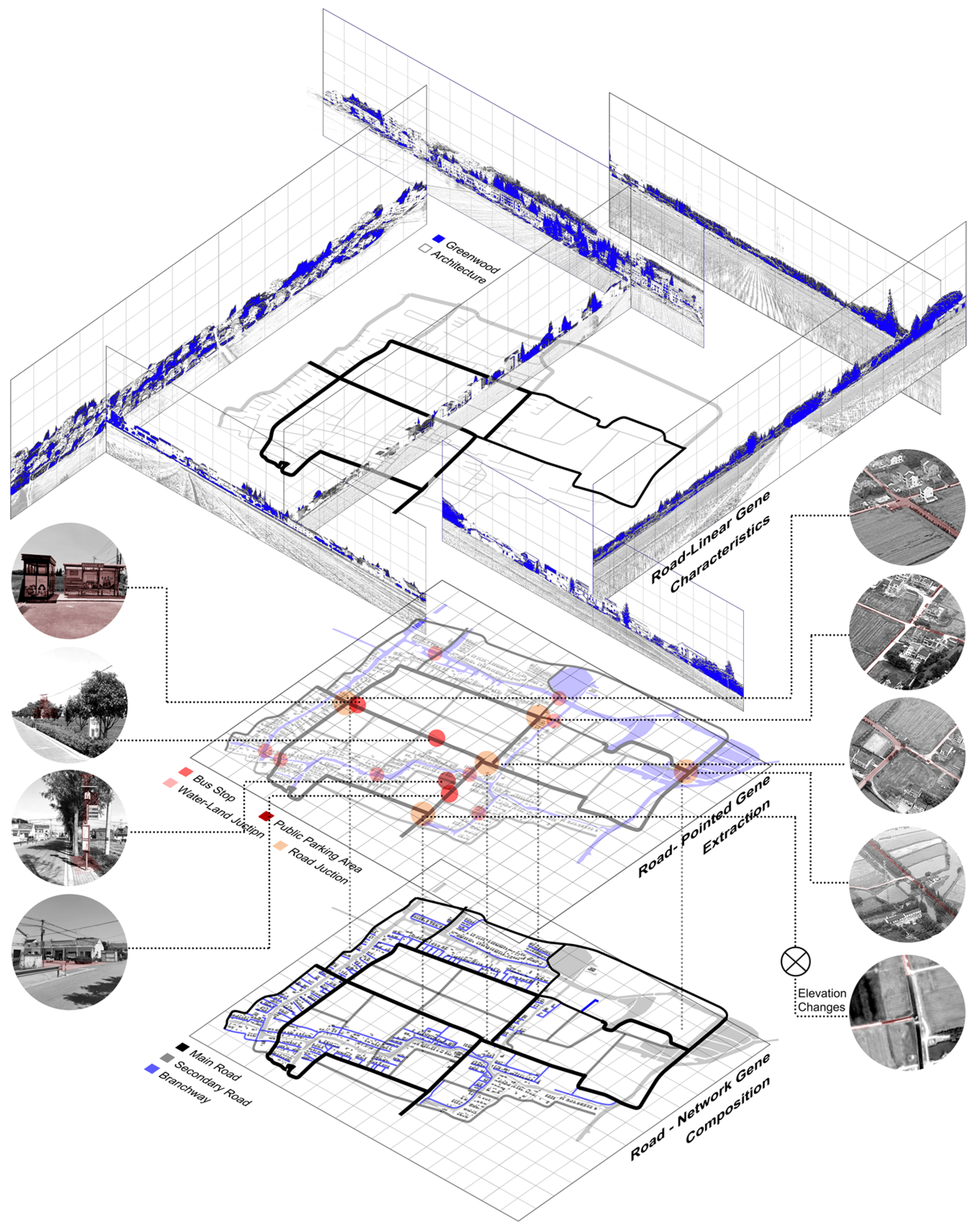
3.1.3. Ground: Road Gene

Relying on the ecological baseline, the road system forms the traffic skeleton of the rural settlement. During its evolution, it gradually replaced traditional water transport, becoming the main mode of transportation for daily production and life in the village (Figure 7).
Point genes mark road intersections, water–land connection points, transit stops, and public parking spots, providing precise positioning for future functional integration and facility improvement. The entire village has two bus stops (at the southeast village entrance and the midwest area of village) and a few public parking spots at the village entrance. Global public parking facilities are severely lacking, and waiting spaces are rudimentary and isolated from the environment, requiring modification and completion in subsequent renewals. Furthermore, the bus terminus in the midwest of the village has transportation hub potential, containing parking space and waiting areas; it is a core target for inserting public service functions and activating spatial vitality in the future.
Line genes focus on the morphology, interface characteristics, and spatial atmosphere of each road section, providing the basis for landscape continuation. The greening density on both sides of Xinyuan Village’s main roads is relatively low, presenting an overall sparse and open spatial landscape. Different road sections form differentiated interfaces based on the settlement fabric. The “O-shaped” fabric sections are dominated by continuous building facades, with buildings and greenery interlocking, presenting a “village enclosing fields” spatial atmosphere. The near “T-shaped” fabric sections are enclosed jointly by building and ecological facades, displaying an open ecological pattern of “fields enclosing villages, forests enclosing fields.” Such continuous linear landscape differences are regional characteristics that must be prioritized for continuation in future renewals.
Network genes coordinate the overall road layout and hierarchical skeleton, systematically revealing Xinyuan Village’s structural features of following the water ring and branching progressively. Relying on the ecological water ring, the village roads form a “C-shaped” ring core arterial, which, together with the internal “cross” arterials, constitutes the overall pattern. The cross-arterials and field sub-arterials interlace into a grid skeleton, progressively deriving fishbone-like branch roads and inter-house roads, constructing a “main-secondary-branch” tiered road network. The overall layout conforms to the village’s ecological baseline and settlement fabric, rigorously and orderly supporting the settlement’s overall traffic operation.

3.2. Horizontal Spatial Coupling Characteristics and Bidirectional Atlas Network

“Surface gene” is the overall spatial pattern shaped by horizontally interweaving the point, line, and surface gene elements extracted from the vertical identification of architecture, ecology, and road genes, reflecting the synergy among elements. Through horizontal overlapping, it presents the ternary structure of Xinyuan Village: “village enclosing fields, fields enclosing village, village adjoining water.” The “θ-shaped” water network dictates the road layout; the roads divide the farmland in a chessboard pattern; the village houses are linearly nested along the water veins; green forests fill the adjacent spaces between water with house and field with house; architectural interfaces and ecological interfaces couple and interweave.
Based on the dismantling and recombination of the above gene elements, a bidirectional gene atlas network of Xinyuan Village can be established from the perspective of morpho-ecological co-evolution (Figure 8). In this perspective, a “gene” is defined as the minimum functional unit maintaining rural functions. Through coupling mode classification, Xinyuan Village presents an intertwined figure-ground characteristic: “roads divide fields, paths lead to houses; water encloses fields, houses on both sides; houses are connected, fields in between; green embeds gaps, forests return to banks.” This mechanism of co-evolution makes the rural space not just an accumulation of morphological symbols, but an organic living entity with ecological resilience and social functions, providing a quantifiable basis of “spatial tolerance” for refined renewal control.

3.3. The Landscape Heat Map

3.3.1. Summary of Entity Factors

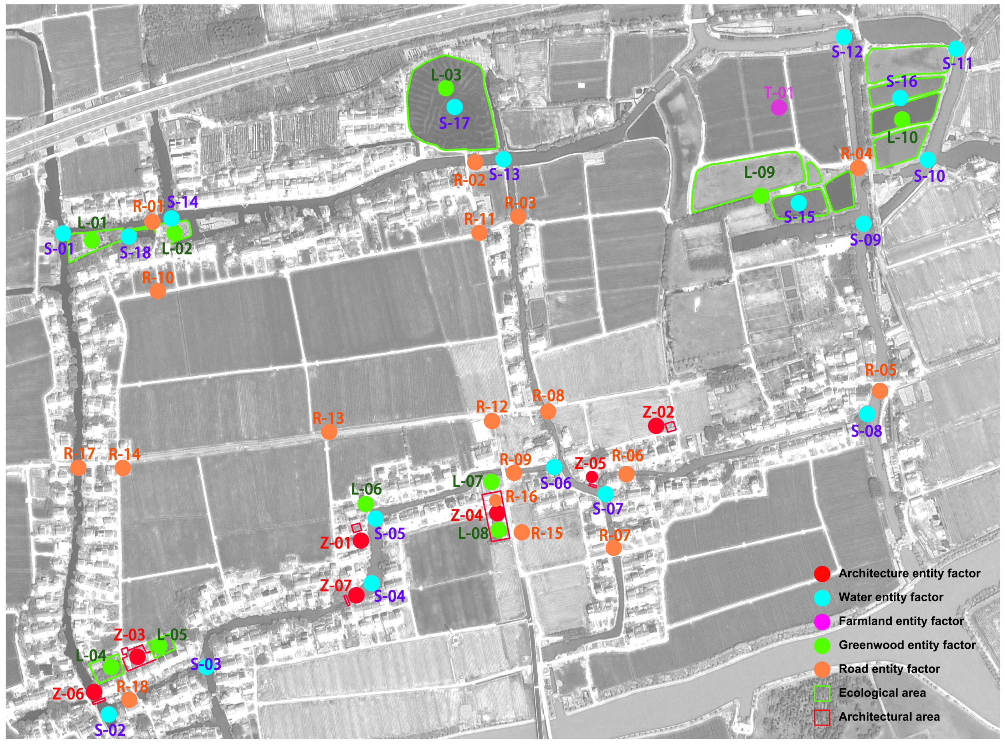
Based on previous field investigations and gene element sorting in Xinyuan Village, 7 architectural characteristic entity factors were identified, covering characteristic historic buildings, public clusters, and structural ornaments. By integrating the three ecological elements of “water-field-forest,” 29 ecological characteristic entity factors were identified. Combined with road nodes, 18 road characteristic entity factors were identified. Examples of the factor list and location numbering are shown below (Figure 9).

3.3.2. Data Standardization and Weight Determination

To ensure comparability across different types of evaluation indicators and to eliminate bias caused by the dimensionality, order of magnitude, and numerical range, this study first performed Min–Max normalization on the raw observation values of each characteristic factor. All indicator data were uniformly mapped to the closed interval [0, 1], achieving a dimensionless transformation of the data, laying the foundation for subsequent objective weighting and comprehensive evaluation [78].
After completing data standardization and constructing a standard data matrix, this study used the EWM to calculate the weights of each evaluation dimension and specific indicator (Table 3). Weights are determined based on the size of the indicator’s information entropy. The smaller the information entropy, the higher the degree of dispersion and the stronger the discrimination ability of the indicator, hence, the higher the corresponding weight [79]. This effectively avoids the bias caused by subjective weighting and ensures the objectivity and scientificity of the evaluation results.
The calculation results indicate that Feature Rarity, Clustering Coefficient, and Type Rarity are the three core dimensions affecting the comprehensive evaluation of characteristic factors, with a cumulative weight of 80.02%. Specifically, the 47.56% weight of Feature Rarity is driven by the data dispersion of the indicator itself, rather than subjective assignment. The uneven spatial distribution of rare heritage elements such as ancient and historic bridges in Xinyuan Village leads to a high degree of data dispersion and strong discrimination ability, so the EWM assigns a higher weight to this indicator. To test and avoid the potential crowding-out effect of this weight distribution on the protection of the village’s overall common texture, the Equal-Weight Method was designed for robustness verification, which eliminates the weight bias of a single indicator and only evaluates the spatial agglomeration of all factors. The result means that the evaluation system balances the evaluation of unique features and the overall clustered texture of the village.
In contrast, the weight of the indicator for the types of elements within the visible range of each factor is relatively low. The main reason is that within the study site, elements such as architecture, water systems, farmland, and greenery are highly organically interwoven with similar spatial allocation patterns, resulting in small differences in the composition of visible elements around each factor and limited discriminability. Therefore, in the evaluation of differences among qualitatively filtered characteristic factors, the evaluation system focuses more on the factor’s own form and type characteristics, as well as its association strength and structural position in the overall spatial network, rather than the diversity differences of external visible elements.

3.3.3. Heat Maps: Characteristic Heat Map and Equal-Weight Heat Map

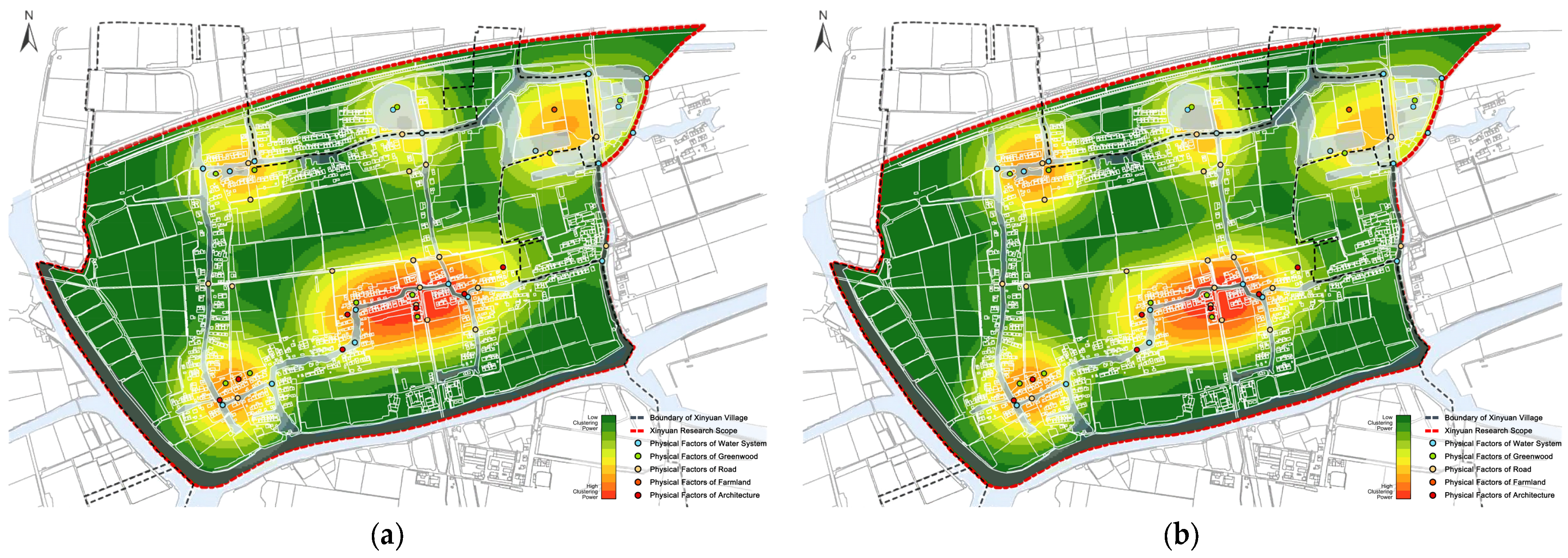
To intuitively present the spatial clustering status and value distribution characteristics of Xinyuan Village’s characteristic factors, this study imported the factor point layer equipped with the “Characteristic Value Index” attribute into the ArcGIS 3.1.5 spatial analysis platform and used the KDE tool for spatial simulation calculation. The core parameters of this analysis were set as follows: taking the Xinyuan Village characteristic factor point layer as input point features, using the “Comprehensive Score” from the factor attribute table as the weight population field, and setting the output cell size to 5 m to ensure spatial expression accuracy. After running, the tool generated a continuous characteristic value density raster layer, i.e., the Entropy-weight Heatmap (Figure 10a). The value of each pixel in the map comprehensively considers the comprehensive value weights of surrounding factors, intuitively reflecting the value clustering degree of characteristic factors within the corresponding spatial range.
To verify the stability of this evaluation result, the study used an Equal Weight Method to recalculate the comprehensive scores of factors and conducted KDE analysis again using the same parameters and processes to generate an equal-weight characteristic clustering heat map (Figure 10b).
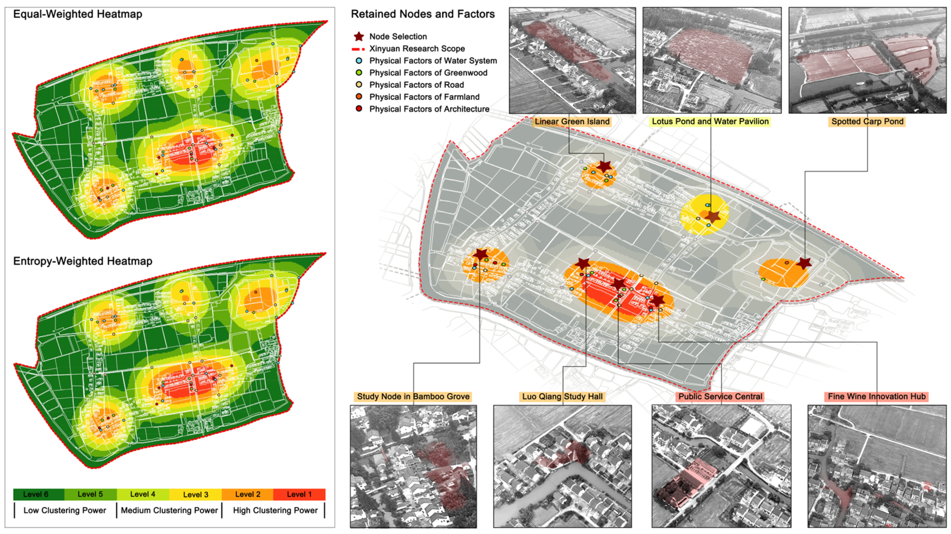
By reclassifying both the Equal-Weight and EWM heat maps into six levels and overlaying them spatially, it was found that their overall distribution patterns matched highly. The central positions of the high-value clustered areas basically coincided, with only minor differences at the edges of the hotspots, and the core management and control scopes remained highly consistent. This result indicates that the screening conclusions for characteristic clustered nodes in Xinyuan Village are minimally affected by weight settings, demonstrating that the constructed evaluation model has excellent robustness. At the same time, based on the Equal-Weight Method, EWM further strengthened the discriminative efficacy of key indicators, making the boundary outlines of hotspot areas clearer. Designate the areas in the top two categories after reclassification as core renewal sites, the determination results of the two methods were generally unified, with significant differences existing only in the lotus pond area in the middle of the north street.
The core reason for the discrepancy between the results of the two methods lies in the following. In the Entropy Weight Method, the “Feature Rarity” indicator was assigned the highest weight, and the high scores of this indicator were concentrated in historical architectural characteristic factors. In contrast, the lotus pond area is dominated by ecological elements such as water bodies and characteristic greening, with relatively single types of characteristic monomers and a scattered spatial distribution of factors. Thus, the comprehensive scores of the “Water system Gene” factor S-17 and “Greening Gene” factor L-03 in the lotus pond area in the EWM evaluation system are 0.455 (ranked 7th among all 54 samples) and 0.351 (ranked 15th among all samples), respectively. Compared to the Equal-weight results, the high-value of Feature Rarity is not particularly noticeable.
However, the Equal-Weight Method eliminates the weight bias of a single indicator and balances the prominent advantage of architectural factors. The large-area continuous water surface and highly spatially aggregated ecological elements in this area can be fully reflected, so the area presents a high aggregation brightness in the Equal-Weight heatmap.
Based on the different but relatively close evaluation results of the EWM and the Equal-Weight Method, the study conducted further field investigation and analysis of this area. It is found that the lotus pond possesses an extensive water landscape, offering excellent ecological recreational value, high spatial carrying capacity and long-term development potential. Therefore, although the value of this area differs from that of the first-priority renewal nodes, it can be listed in the transformation and optimization sequence of the future ecological leisure and folk experience expansion zone.
Moreover, the boundary delineations of both heat maps were generally consistent for the low-value areas identified around the high-value areas, which were influenced by factors with low characteristic contributions. When finally determining the core renewal points, the study combined the factor distribution characteristics of both heat maps and eliminated factors whose levels did not enter the top two tiers and had weak characteristic contributions, thereby ensuring the targeted and practical effectiveness of subsequent renewal works.

4. Discussion

This study takes Xinyuan Village, a typical “Shanghai-style Jiangnan” village, as the research subject. Based on the “point-line-network” spatial gene identification, it constructs a bidirectional gene atlas network and dual-verified heat map analyses. By quantifying the clustering characteristics of spatial genes, this study breaks through the limitations of static, vague, and homogenized approaches in traditional rural landscape preservation, attempting to achieve a dynamic balance between preservation-inheritance and modern adaptation, providing a scientific path for the resilient governance of rural spaces.

4.1. Zoning Control Path from Static Landscape Preservation to Dynamic Hierarchical Renewal

Traditional preservation of Jiangnan rural landscapes mostly adopts a comprehensive static protection model, which generally suffers from vague protection boundaries and monotonous renewal strategies [80], making it difficult to adapt to the dual demands of preservation and development in peri-urban villages of megacities. Through the dual-verified multi-element weighted characteristic value heat maps (EWM and Equal-Weight Method), this study precisely identifies the spatial differentiation characteristics of landscape values in Xinyuan Village (Figure 11).
For the discrepancy between the EWM and the Equal-Weight Method, this study establishes a three-step standardized resolution principle: (1) if the core high-value areas of the two heat maps are highly consistent and only the edge level of individual areas is different, the area will be classified as a secondary potential node, and the final classification will be determined in combination with field research; (2) if there is a significant deviation in the core high-value areas of the two methods, the weight system will be rechecked, and the indicator system will be optimized in combination with the local characteristics of the village; (3) for areas with high value in the Equal-Weight heatmap but low value in the Entropy-Weight heatmap, priority will be given to verifying their overall texture value through field research, and they will be included in the renewal scope as supplementary nodes to avoid missing the protection of common clustered features.
By overlaying two heatmaps, the study finds that high-characteristic clustering areas are concentrated on South Street and North Street. South Street centers on cultural and architectural characteristic factors, focusing on the aggregation of intangible humanistic customs and tangible historical buildings, carrying the village’s folk culture and historical memory. North Street is dominated by ecological baseline factors, relying on the ecological baseline with the widest green forest width and significant landscape benefits, preserving the original nested fabric of “water-field-forest.” In contrast, the middle and west block areas have relatively weak characteristic values due to their plain and monotonous fabrics, and the problem of landscape homogenization is more severe. The results of this quantitative assessment clearly delineate high-value conservation areas from general renewal areas, defining the “tolerance” of different spaces toward development interventions. This resolves the core issue of unclear boundaries in traditional conservation and provides quantitative data support for differentiated spatial management [81].
Based on this, this study proposes a “Three-Tier Differentiated Control Strategy” for rural spaces, guiding rural areas from static preservation to dynamic adaptation.
  • Core Conservation Zone (Level 1–2): Corresponding to the extremely high-value areas in the heat map, encompassing the ecological core and cultural anchors, this area is the core of the village’s landscape gene pool. This area should abandon large-scale demolition and reconstruction, adopting an acupuncture-style micro-renewal approach based on the principles of preventive conservation and restoration to the original condition [82]. Through subtle physical spatial interventions and strict preventive preservation, the original authenticity of characteristic historical buildings (like Luoqiang House and Guanyindou House) and core ecological nodes should be retained.
  • Landscape Buffer Zone (Level 3–4): Corresponding to the mid-value areas identified in the heat map, mainly distributed at the road–water intersection nodes at the four corners of the village. This area allows for adaptive functional replacement and moderate transformation but must adhere to the spatial gene prototypes of buildings and landscape and the texture logic of the village. To ensure practical operability, quantitative control thresholds are proposed. (1) Building renovations must continue the architectural pitched roof form and control the building volume. Building height shall be controlled within two floors (≤7 m), and the total volume change rate shall not exceed ±15% compared with the original volume, consistent with traditional features of Shanghai-style Jiangnan vernacular dwellings. (2) For landscape renewal, the waterfront interface permeability shall be maintained above 60% to retain the semi-open texture. Large-area water landscapes (such as the lotus pond area) shall be prohibited from large-scale morphological transformation. The retention rate of original water bodies shall not be less than 85%, and the total construction area of hardened revetments and newly built supporting facilities shall not exceed 15% of the total land area of the landscape, so as to avoid disturbance to the ecological fabric of the area and the overall rural landscape caused by excessive development. (3) The overall settlement texture (road–water–house pattern) shall remain unchanged, and the original linear arrangement and spatial rhythm shall be maintained.
  • Adaptive Renewal Zone (Level 5–6): Corresponding to the low-value areas in the heat map, such as the middle and west blocks. Such an approach minimizes disruption to the overall core character of the rural landscape and offers high compatibility. Planning can adopt intensive construction here, inserting public service facilities that meet modern living demands. For example, fully utilizing the bus station with hub potential on the mid-west side to supplement the public parking and waiting spaces to stimulate rural vitality.

4.2. Rural Resilience Enhancement Based on Spatial Gene Narrative Reconstruction

Guided by the national Rural Revitalization Strategy, Xinyuan Village has undertaken multiple rounds of renovation projects focused on improving living standards, upgrading infrastructure, and restoring the ecological environment over the past 30 years (refer to Section 2.1). However, based on the field research and social interviews in Xinyuan Village, it can be seen that although the improvement of these basic physical conditions has effectively enhanced the quality of villagers’ lives, it has failed to fully inherit and develop the collective rural life and traditional folk culture. Essentially, the decline of rural areas in metropolitan suburbs, such as Xinyuan Village, is a coupled evolutionary process characterized by the physical spatial fabric degradation, spatial narrative fragmentation, and the erosion of community cultural identity; one-dimensional physical spatial renewal alone is insufficient to achieve the sustainable rural development of rural communities [83]. The materiality of the countryside and human society are in a state of constant interaction and co-production. Rural architecture and public spaces are not static landscape entities, but rather core venues that carry the collective memory of villagers and facilitate the co-production of people and the built environment; their functional abandonment and the deterioration of their character directly lead to a rupture in the rural cultural fabric and the erosion of local identity [58]. Therefore, the essence of rural conservation and renewal lies more in systematically uncovering distinctive features, enhancing local experiences, and establishing a contextual logic [84]. Based on the “point-line-network” hierarchical logic of the bidirectional gene atlas network, this study builds a spatial narrative reconstruction framework of “node clustering activation-linear sequence splicing-network domain optimization” (Figure 12). Its internal logic is highly consistent with the structural transitions, path selections, and thematic tones of spatial narratives, thereby building an implementable spatial support system for synergistic improvement of rural ecological, cultural, and social resilience.
  • Node Activation: Through the spatial superposition analysis of the “point genes” of architectural, ecological, and road gene types, combined with the systematic identification of historical context carriers in the village and the on-site research and judgment of spatial use characteristics, seven core characteristic clustering nodes of Xinyuan Village are delineated. These places are not only highly consistent with the renewal sites identified in the heatmap, but also cultural and ecological anchors bearing villagers’ collective memories and tourists’ perceptions, covering historical architectures with regional iconicity (such as Luoqiang House and old Xinyuan Primary School), public spaces carrying long-term production and living memories (such as the general store and fish ponds), and landscape nodes with core ecological value (such as the lotus pond and paddy fields). Interview results show that the current core context carriers of the village have problems such as a lack of protection and functional abandonment, superimposed on the intergenerational memory transmission gap caused by the aging population structure and the loss of the adolescent population, and the spatial carrier of the village’s collective memory is continuously weakened. In response to this situation, through precise renewal of these seven node spaces, spatial vitality can be effectively activated, which provides a core spatial carrier for the living inheritance of the village context and the reconstruction of local identity.
  • Line Connection: Addressing the partial spatial fragmentation and traffic chain fracture caused by the evolution of rural land–water transportation, the study combined the existing traffic organization, commercial activity distribution, and public recreation demands, and proposes reconnecting spatial relationships through narrative tour route system. Based on the linear organizational features of each block, two differentiated thematic routes are customized. North Street’s “Waterfront Ecological Tour Route” is built relying on organic water surface morphology and richly layered waterfront greenery, connecting the existing waterfront leisure nodes for fishing and lotus viewing formed in the northeast corner of the village; South Street’s “Street Experience Tour Route” connects dense historic humanistic buildings and folk nodes, linking the formed agricultural and leisure commercial activities around the village to create a humanistic experience tour route. Furthermore, relying on the Fengjing Line 1 bus line running through the village and the contiguous farmland fabric in the center of the village, pastoral walking trails should be embedded in farmlands to create the immersive agricultural experiences and improve the village-wide recreation system. This set of the narrative tour route system builds a complete linear spatial skeleton for the release of multiple rural values and the enhancement of commercial activity vitality, effectively stimulating the comprehensive economic vitality of the village.
  • Network Optimization: The bottom line of spatial resilience lies in maintaining the integrity of the ecological baseline. Therefore, the renewal and transformation of Xinyuan Village must be carried out on the basis of strictly protecting the existing ecological spatial structure of the village. The highly isomorphic relationships of the θ-shaped grid water network, the cross tiered road network, and the grid-patterned polders are the core barrier of the village’s ecological security, as well as the original spatial background formed by the villagers’ long-term production and life. By maintaining the ternary macro-pattern of “village enclosing fields, fields enclosing village, village adjoining water” and the figure-ground interweaving feature of “water-field-forest-house,” the ecosystem service functions of the village such as hydrological regulation and microclimate circulation can be guaranteed, and the ecological base framework for spatial narrative reconstruction can be built, thus ensuring the ecological resilience of rural hydrological regulation and microclimate circulation.
Through the overall spatial narrative reconstruction of the “point-line-network” system, this study realizes the systematic restoration of the rural physical spatial fabric and the integrity construction of the spatial narrative system. The process of revitalizing traditional rural spaces is, in itself, a process of co-creation between people and the built environment. The spatial reconstruction framework developed in this study is based precisely on the systematic optimization of the core physical infrastructure of rural areas, providing a whole-process spatial implementation path for the inheritance of village context, maintaining community identity and enhancing social resilience. It also offers technical planning support to address the risk of rural disintegration during urbanization [85]. In the subsequent implementation stage, the quantitative atlas constructed in this study will also provide a platform for negotiation and a foundation for consensus among government-led baseline controls, market-driven cultural and tourism development, and villagers’ spontaneous community-building initiatives [86] and facilitate the living inheritance and sustainable governance of the “Shanghai-style Jiangnan” rural landscape. It should be noted that this study focuses primarily on the quantitative analysis of rural spatial forms and the development of spatial strategies for landscape management. While the aforementioned spatial framework provides a core spatial carrier for the implementation of rural sociocultural initiatives, its long-term practical impact on enhancing community resilience still requires further validation through ongoing monitoring and systematic empirical research.

4.3. Research Limitations and Future Directions

Based on the empirical investigation and element analysis of Xinyuan Village, this study constructs a quantitative analysis and renewal management framework for rural landscape genes, which shows good application value in the conservation and renewal of water town villages in Shanghai-style Jiangnan. Constrained by the research design, methodological path, and research dimensions, this study still has certain applicable scope and limitations. First, the validity of the model is only verified in the single case of Xinyuan Village, and the external validity test has not been completed through cross-regional comparative studies of multi-type villages, so the universality and applicable scope of the model still need to be further clarified. Meanwhile, the weight distribution of the Entropy Weight Method (EWM) is driven by the data characteristics of the case site. Although the high weight of the feature rarity indicator adapts to the discrete distribution characteristics of historical heritage in Xinyuan Village, it has adaptability limitations in villages with a more homogeneous element distribution, which restricts the direct cross-scenario application of the model to a certain extent. Second, the indicator selection and weight assignment need to be manually traded off in combination with the local characteristics of the village. Although this design ensures the local adaptability of the model, there is still some room for subjective intervention, and the objectivity of quantitative analysis still has room for improvement. At the same time, data acquisition and the indicator calculation of the study are highly dependent on manual field research, resulting in low data-acquisition efficiency and a lack of automated technical support. Third, the study mainly focuses on the analysis and management at the physical spatial level, with insufficient quantitative integration of intangible cultural elements such as folk culture and collective memory. The long-term effect of the spatial framework on the improvement of community social resilience still needs to be systematically verified through continuous follow-up monitoring.
In response to the above limitations, future research will be gradually optimized and improved in three directions. First, carry out multi-case cross-regional empirical research, select samples of Shanghai-style Jiangnan villages with different water network patterns and geomorphological characteristics, complete the validity verification and adaptability optimization of the model, and clarify the applicable scope and universality rules of the model. Second, integrate cutting-edge digital technologies such as high-resolution remote sensing images, UAV aerial photography, GIS spatial analysis, and AI semantic segmentation, to build a batch automatic extraction path of core landscape elements and automated calculation path of evaluation indicators, so as to improve data-processing efficiency. Meanwhile, a cross-case standardized evaluation indicator database will be established, and the weight assignment system will be optimized combined with machine learning algorithms, to reduce manual subjective intervention and improve the objectivity and universality of the model. Third, intangible cultural elements will be incorporated into the evaluation system to improve the full-dimensional analytical framework of rural landscape genes. Long-term dynamic follow-up monitoring will be conducted to verify the long-term effect of spatial strategies, so as to provide technical support for the living inheritance and sustainable governance of the rural landscape under the background of rural revitalization.

5. Conclusions

Against the policy background of the full advancement of the National Rural Revitalization Strategy, the homogenization of rural landscape and the loss of cultural genes have become the core pain points of rural conservation and renewal nationwide. Based on this key point, the study of Xinyuan Village’s “Shanghai-style Jiangnan” landscape genes cover multiple dimensions, including architectural forms, ecological elements, and cultural heritage, permeating the entire “point-line-network-surface” hierarchy, and profoundly demonstrating the unique spatial integration of land–water coexistence and Sino-Western fusion. Facing landscape evolution and preservation conflicts brought about by rapid urbanization and concentrated construction, this study takes Xinyuan Village as an empirical case and verifies the effectiveness of the bidirectional gene atlas network combined with landscape sensitivity assessment in the precise conservation and differentiated renewal of rural landscape.
Theoretically, the study integrates landscape gene and spatial gene theories. The constructed bidirectional analytical framework compensates for the core limitations of existing research that focuses on vertical elements dismantling while ignoring horizontal typological correlations, enriching the analytical paths for the physical aspects of rural transformation and cultural interpretations of rural regional value, and responding to the core requirement of “retaining local landscape and inheriting regional culture” in the Rural Revitalization Strategy.
At the practical level, through dual quantitative calculations superimposing weights of multiple elements, the resulting heat maps can precisely identify the spatial differentiation of village landscape values and define preservation and renewal boundaries, thus constructing a three-tier differentiated control strategy. Built upon the research findings, the narrative reconstruction framework of “node clustering activation, linear sequence splicing, network domain optimization” builds a scientific bridge between micro-gene element identification and macro-zoning planning control, providing an implementable quantitative tool for the preservation and renewal of “Shanghai-style Jiangnan” villages.
This study not only provides an in-depth local case for rural transformation in the peri-urban areas of Chinese megacities, supplementing the existing literature on rural evolution and sustainable development in developing countries; more importantly, it proposes a highly operational preservation and renewal model based on gene quantification. At present, the effectiveness of this model has been verified in the case of Xinyuan Village and is recognized as an analytical model with promotion and application potential, while its applicability to other water town villages in Shanghai and even the whole country still needs further empirical verification. The research shows that in the long-term dynamic process of rural renewal, only by precisely locking onto and evaluating the sensitivity of spatial “genes” through scientific methods can we retain nostalgia and memories while improving modern living environments, fundamentally maintaining the dual physical and social resilience of the countryside under the background of the Rural Revitalization Strategy.

Author Contributions

Conceptualization, Z.L., M.T., Q.L., Y.Z. and F.D.; methodology, M.T. and Q.L.; software, M.T. and Q.L.; validation, M.T. and Q.L.; formal analysis, M.T., Q.L. and F.D.; writing—original draft preparation, M.T. and Q.L.; writing—review and editing, Z.L., M.T., Q.L. and Y.Z.; visualization, M.T. and Q.L.; supervision, Z.L., Y.Z. and F.D. All authors have read and agreed to the published version of the manuscript.

Funding

This research was funded by the National Natural Science Foundation of China, grant Nos. 52578040 and 52078345.

Data Availability Statement

The original contributions presented in this study are included in the article. Further inquiries can be directed to the corresponding author.

Conflicts of Interest

The authors declare no conflicts of interest.

Appendix A

Table A1. Entity factors and original evaluation of architecture.
CategoryCodeEntity FactorFeature RarityType RarityVisual Openness Intersection TypeNode DegreeClustering Coefficient
Distinctive Historic BuildingsZ-01Luoqiang House1/1
(Distinctive Roof Form)
1/2
(Distinctive Historic Building)
0.3521
Z-02Guanyindou
House
1/1
(Distinctive
Gable Form)
1/2
(Distinctive Historic Building)
0.74400
Public GroupingsZ-03Xinyuan
Primary School
1/4
(Historical
Element)
1/1
(Cultural
Building)
0.58431
Z-04General Store
Activity Center Medical Clinic
01/2
(Public
Grouping)
0.92550.5
Miniature StructuresZ-05Stone Boat1/4
(Historical
Element)
1/3
(Miniature
Structure)
0.22421
Z-06Taiping Bridge1/4
(Historical
Element)
1/3
(Miniature
Structure)
0.56420.67
Z-07Xiucai Bridge1/4
(Historical
Element)
1/3
(Miniature
Structure)
0.23410
Table A2. Entity factors and original evaluation of water system.
CategoryCodeEntity FactorFeature RarityType RarityVisual Openness Intersection TypeNode DegreeClustering Coefficient
Water
System
Intersection
S-01Northwest
Mutation Point 1
01/8
(3-branch intersection)
0.81410
S-02Southwest
Mutation Point 1
01/1
(Canal)
0.44421
S-03Southwest
Mutation Point 2
01/8
(3-branch intersection)
0.25410
S-06Central
Mutation Point 1
01/8
(3-branch intersection)
0.24400
S-07Central
Mutation Point 2
01/8
(3-branch intersection)
0.18421
S-08Southeast
Mutation Point
01/3
(3-branch intersection)
0.49410
S-09Northeast
Mutation Point 1
01/8
(4-branch intersection)
0.93500
S-10Northeast
Mutation Point 2
01/3
(4-branch intersection)
1400
S-11Northeast
Mutation Point 3
01/8
(3-branch intersection)
1300
S-12Northeast
Mutation Point 4
01/8
(3-branch intersection)
1200
S-13Central
Mutation Point 3
01/3
(4-branch intersection)
0.98421
S-14Northwest
Mutation Point 2
01/8
(3-branch intersection)
0.76431
Mutation Point of
Water
System
S-04South Street Mutation Point 101/2
(Mutation Point)
0.31410
S-05South Street Mutation Point 201/2
(Mutation Point)
0.23421
Distinctive Water
System
S-15Fish Scale
Pond 1
1/2
(Polder)
1/3
(Distinctive Form)
0.97530.67
S-16Fish Scale
Pond 2
1/2
(Polder)
1/3
(Distinctive Form)
1350
S-17Lotus
Pond
01/1
(Special Category)
1231
S-18Organic
Waterfront
01/3
(Distinctive Form)
0.53440.67
Table A3. Entity factors and original evaluation of greenwood and farmland.
CategoryCodeEntity FactorFeature RarityType RarityVisual Openness Intersection TypeNode DegreeClustering Coefficient
Distinctive GreenwoodL-01North Street
Green Island 1
01/2
(Linear Green Island)
0.53440.67
L-02North Street
Green Island 2
01/2
(Linear Green Island)
0.72431
L-03Lotus Pond01/3
(Special Category)
1231
L-04Bamboo Forest 101/3
(Special Category)
0.51430.67
L-05Bamboo Forest 201/3
(Special Category)
0.5510
L-06Corner Park 101/3 (Park)0.11421
L-07Corner Park 201/3 (Park)0.68431
L-08Park 301/3 (Park)0.78330.67
L-09Wetland 101/2 (Wetland)0.97540.67
L-10Wetland 201/2 (Wetland)1350
Distinctive FarmlandT-01Polder1/1
(Polder)
1/1
(Distinctive Water-
surrounded Field)
1440.5
Table A4. Entity factors and original evaluation of road.
CategoryCodeEntity FactorFeature RarityType RarityOpenness DegreeIntersection TypeNode DegreeClustering Coefficient
Water-Land JunctionR-01Bridge 101/11
(Water-Land Junction)
0.67431
R-02Bridge 201/11
(Water-Land Junction)
0.8431
R-03Bridge 301/11
(Water-Land Junction)
0.79500
R-04Bridge 401/11
(Water-Land Junction)
1400
R-05Bridge 501/11
(Water-Land Junction)
0.47410
R-06Bridge 601/11
(Water-Land Junction)
0.31421
R-07Bridge 701/11
(Water-Land Junction)
0.36400
R-08Bridge 801/11
(Water-Land Junction)
0.94500
R-09Bridge 901/11
(Water-Land Junction)
0.65431
R-17Bridge 1001/11
(Water-Land Junction)
0.38410
R-18Bridge 1101/11
(Water-Land Junction)
0.32430.67
Road
Junction
R-10Main Road
Junction 1
01/3
(Road Junction)
1200
R-11Main Road
Junction 2
01/3
(Road Junction)
0.75400
R-12Main Road
Junction 3
01/3
(Road Junction)
0.94400
Functional PointR-13Waypoint 101/4
(Stopping Point)
1300
R-14Bus Terminal01/4
(Stopping Point)
0.64400
R-15Waypoint 201/4
(Stopping Point)
0.81421
R-16Public
Parking Area
01/4
(Stopping Point)
0.32441

Appendix B

Table A5. Comprehensive scores of factors.
Factor CodeComprehensive ScoreRanking
T-010.8841
Z-010.8222
Z-020.6043
Z-030.5724
S-150.5585
S-160.4646
S-170.4557
Z-050.4258
S-020.4219
L-020.38310
Z-060.38211
L-090.37112
Z-040.36113
L-070.35414
L-030.35115
R-160.34716
S-130.34617
L-010.33618
S-050.33319
S-140.32720
R-150.32521
R-020.32422
R-010.31723
R-090.31624
S-180.31025
L-060.30026
L-080.28927
L-040.28528
R-060.27329
S-070.27230
L-100.25331
R-180.23732
Z-070.21833
S-040.12934
L-050.12435
S-100.11636
R-120.11337
S-080.11338
R-110.10339
S-010.09840
R-100.09541
R-130.09342
S-090.09143
R-080.08644
R-140.08445
R-040.07946
R-030.07847
R-050.07448
S-110.07449
R-170.07050
S-030.06851
S-120.06352
R-070.04453
S-060.04354

References

  1. Xie, K.; Zhang, Y.; Han, W. Architectural Heritage Preservation for Rural Revitalization: Typical Case of Traditional Village Retrofitting in China. Sustainability 2024, 16, 681. [Google Scholar] [CrossRef]
  2. Perkins, H.C.; Mackay, M.; Wilson, J. Community-Led Heritage Conservation in Processes of Rural Regeneration. J. Place Manag. Dev. 2023, 16, 367–387. [Google Scholar] [CrossRef]
  3. Torner-Feltrer, M.E.; Barelles-Vicente, E.; Besana, D.; Cañada-Soriano, M. Architecture for Rural Renewal: Reconstructing the Domestic Fabric of Abandoned Settlements for New Sustainable Uses. Buildings 2025, 16, 67. [Google Scholar] [CrossRef]
  4. Wei, K.; He, Y.; Wang, M.; Zhu, R.; Wang, Z. Identification, Inheritance and Restoration of Traditional Village Landscape Gene: A Case Study of Lidipo Village in Tongchuan, Shaanxi Province. npj Herit. Sci. 2025, 13, 18. [Google Scholar] [CrossRef]
  5. Gu, X.K.; Li, X.T.; Liu, J. Rural Spatial Governance in Metropolis Based on IAD Theoretical Framework: A Case of Langxia Town, Jinshan District of Shanghai. Hum. Geogr. 2023, 38, 100–107. (In Chinese) [Google Scholar] [CrossRef]
  6. Xu, H.; Pittock, J.; Daniell, K.A. China: A New Trajectory Prioritizing Rural Rather than Urban Development? Land 2021, 10, 514. [Google Scholar] [CrossRef]
  7. Liu, Y.S.; Zhou, Y.; Li, Y.H. Rural Regional System and Rural Revitalization Strategy in China. Acta Geogr. Sin. 2019, 74, 2511–2528. (In Chinese) [Google Scholar]
  8. Shanghai Municipal Bureau of Planning and Natural Resources. Special Planning for the Protection and Inheritance of Characteristic Village Landscapes in Shanghai (2024–2035); Research Report; Shanghai Municipal Bureau of Planning and Natural Resources: Shanghai, China, 2024. (In Chinese) [Google Scholar]
  9. Wang, Y.T.; Zheng, J.T. Cultural Context Cultivation, Shanghai-style Jiangnan. China Comment 2024, 12. Available online: http://www.banyuetan.org/wh/detail/20240625/1000200033136031719306673722402430_1.html (accessed on 25 June 2024). (In Chinese)
  10. Wu, J. Water Villages: A Study on the Ecological History of Homes East of Lake Tai; Shanghai Guji Publishing House: Shanghai, China, 2016; Volume 41. (In Chinese) [Google Scholar]
  11. Mao, B. History of Shanghai Port: Ancient and Modern Parts; China Communications Press: Beijing, China, 1990. (In Chinese) [Google Scholar]
  12. Marsden, T.; Murdoch, J.; Lowe, P.; Munton, R.C.; Flynn, A. Constructuring The Countryside; Routledge: London, UK, 2005; ISBN 9781135371869. [Google Scholar]
  13. Song, B.; Robinson, G.M. Multifunctional Agriculture: Policies and Implementation in China. Geogr. Compass 2020, 14, e12538. [Google Scholar] [CrossRef]
  14. Zeng, P.; Ren, X.T.; Man, D. Research on Rural Multi-Level Development Paths in Metropolitan Areas from the Perspective of Urban-Rural Integration: A Case Study of Zaolinzhuang Village in Tongzhou District of Beijing. Mod. Urban Res. 2023, 3, 60–67. (In Chinese) [Google Scholar]
  15. Zhu, N. Research on The Promotion Strategy of Qingdao Waterfront Mountain Type Rural Landscape. Master’s Thesis, Qingdao University of Technology, Qingdao, China, 2022. (In Chinese) [Google Scholar]
  16. Allison, H.E.; Hobbs, R.J. Resilience, Adaptive Capacity, and the “Lock-in Trap” of the Western Australian Agricultural Region. Ecol. Soc. 2004, 9, art3. [Google Scholar] [CrossRef]
  17. Bristow, G.; Healy, A. Crisis Response, Choice and Resilience: Insights from Complexity Thinking. Camb. J. Reg. Econ. Soc. 2015, 8, 241–256. [Google Scholar] [CrossRef]
  18. Anthopoulou, T.; Kaberis, N.; Petrou, M. Aspects and Experiences of Crisis in Rural Greece. Narratives of Rural Resilience. J. Rural Stud. 2017, 52, 1–11. [Google Scholar] [CrossRef]
  19. Hu, S.L.; Yu, B.; Wang, M.J. Rural Restructuring and Transformation: Western Experience and Its Enlightenment to China. Geogr. Res. 2019, 38, 2833–2845. (In Chinese) [Google Scholar]
  20. Woods, M. Engaging the Global Countryside: Globalization, Hybridity and the reconstitution of Rural Place. Prog. Hum. Geogr. 2007, 31, 485–507. [Google Scholar] [CrossRef]
  21. Chang, J.; Zhu, D.D.; Feng, S.S. Renewal of German Villages and the Value of Reference for Domestic New Rural Construction. Archit. J. 2006, 11, 71–73. (In Chinese) [Google Scholar]
  22. Yi, X.; Schneider, C. Integrated Rural Development Strategy and Cultural Identity Cultivation in Germany. Mod. Urban Res. 2013, 28, 51–59. (In Chinese) [Google Scholar]
  23. Wei, Y.S. A Review of Rural Environment Conservation Policies in the United Kingdom and Its Implications for China. Dev. Small Cities Towns 2018, 1, 94–99. (In Chinese) [Google Scholar]
  24. Mosley, S. Review: An Environmental History of Twentieth-Century Britain. Soc. Hist. Med. 2003, 16, 319–320. [Google Scholar] [CrossRef]
  25. Mu, Q.; Ai, B.L.; Chen, L. The Joint Force of bottom-up and top-down in the Preservation and Renewal of Rural Architectural Heritage—Taking Piedmont, Italy as the Case Study. Architect 2021, 34–41. (In Chinese) [Google Scholar]
  26. Chen, R.; Qian, H.; Wang, H.Y. Art Intervention in Rural Renaissance from Governance Structure Perspective: A Positive Study of Setouchi Art Festival. Planners 2016, 32, 35–39. (In Chinese) [Google Scholar]
  27. Zhou, J.M.; Hui, S.S.; Xue, S.W.; Ding, F.; Liu, J. Spread of Cultural Scenery’s Vigor: Trend of the Invigoration of New Rural Construction in Japan. Archit. J. 2011, 46–51. (In Chinese) [Google Scholar]
  28. Zhou, X.Q. Recent Progress of Study on Rural Landscape in the West. Areal Res. Dev. 2007, 3, 85–90. (In Chinese) [Google Scholar]
  29. Liu, Y. Research on the Urban-Rural Integration and Rural Revitalization in the New Era in China. Dili Xuebao/Acta Geogr. Sin. 2018, 73, 637–650. [Google Scholar] [CrossRef]
  30. Central Committee of the Communist Party of China; State Council of the People’s Republic of China. Opinions on Implementing the Rural Revitalization Strategy; No. 1 Central Document of 2018; State Council of the People’s Republic of China: Beijing, China, 2018; Available online: http://nepaper.ccdy.cn/page/1/2018-02/06/2/201802062_pdf.PDF (accessed on 6 February 2018). (In Chinese)
  31. Liu, Y.; Li, J.; Yang, Y. Strategic Adjustment of Land Use Policy under the Economic Transformation. Land Use Policy 2018, 74, 5–14. [Google Scholar] [CrossRef]
  32. Zhang, Y.L.; Li, X.; Sun, S.L. Evaluation and Optimization of Rural Space Suitability Based on “the Production, Living and Ecological Space Coordination” Take Beishakou Township, the Xiongan New Area as an Example. Urban Dev. Stud. 2019, 26, 116–124. (In Chinese) [Google Scholar]
  33. Shao, R.F. Country Planning Study of South of Jiangsu at the Perspective of Texture Protection. Master’s Thesis, Suzhou University of Science and Technology, Suzhou, China, 2016. (In Chinese) [Google Scholar]
  34. Guo, H.A.; Cui, K. A Strategy Study of the Construction of Characteristic Rural Styles and Landscapes Guided by Culture. Archit. Pract. 2019, 31–32. (In Chinese) [Google Scholar]
  35. Chen, M.; Zhang, Z.Y. Study on the Protection and Utilization Planning Strategy of Traditional Vil ages based on Spatial Narrative Theory: A Case Study of Yuliang Village in Shexian County, Anhui Province. Archit. Cult. 2021, 2, 32–33. (In Chinese) [Google Scholar] [CrossRef]
  36. Luan, F.; Pei, Z.X.; Cao, S.; Xin, S.X.; Zhang, Y.; Fan, J.H. Practical Rural Landscape Planning: Framework and Practice. Urban Plan. Forum 2022, 65–71. (In Chinese) [Google Scholar] [CrossRef]
  37. Zhou, Y.L.; Li, B.Y. Research on the Protection and Improvement of Traditional Village Features under the Application of Darning Theory: A Case Study of Qing Shan Village in Qing Dao City. Archit. Cult. 2022, 4, 177–178. (In Chinese) [Google Scholar] [CrossRef]
  38. Zhang, Y.W.; Fan, W.B. Architecture in-situ: Analysis of Several Paths of Rural Construction. Archit. Cult. 2019, 1, 172–174. (In Chinese) [Google Scholar]
  39. Dang, Y.T.; Zhao, K.L.; Wang, X.J.; Liu, J.P. New Patterns of Low Carbon Buildings in Rural Areas Based on Prototype Theory. New Archit. 2024, 90–95. (In Chinese) [Google Scholar]
  40. Wang, Y.X.; Su, Y.; Huang, Z.Y.; Qu, Y.N. Rural Architectural Design Based on the Theory of Metabolic Architecture- An Example of the Architectural Design of Guanglu Island in Changhai County. Green Build. 2024, 5, 54–59. (In Chinese) [Google Scholar]
  41. Denecke, D.; Shaw, G. Urban Historical Geography: Recent Progress in Britain and Germany; Cambridge University Press: Cambridge, UK, 1988. [Google Scholar] [CrossRef]
  42. Liu, P.L.; Liu, C.L.; Deng, Y.Y.; Shen, X.Y.; Li, B.H.; Hu, Z. Landscape Division of Traditional Settlement and Effect Elements of Landscape Gene in China. Acta Geogr. Sin. 2010, 65, 1496–1506. (In Chinese) [Google Scholar]
  43. Liu, P.; Zeng, C.; Liu, R. Environmental Adaptation of Traditional Chinese Settlement Patterns and its Landscape Gene Mapping. Habitat Int. 2023, 135, 102808. [Google Scholar] [CrossRef]
  44. Sa, Q.; Qu, Z.; Liu, Y.; Shan, W. The Strategy of Traditional Chinese Settlement Digitization: A Landscape Information Chain Theory-Based Perspective. Herit. Sci. 2024, 12, 234. [Google Scholar] [CrossRef]
  45. Duan, J.; Jiang, Y.; Li, Y.G.; Lan, W.L. Space Gene: Connotation and Functional Mechanism. City Plan. Rev. 2022, 46, 7–14+80. (In Chinese) [Google Scholar]
  46. Jiang, Y.; Li, Y.G.; Duan, J. Space Gene: An Identification Approach. Urban Plan. Forum 2025, 18–24. (In Chinese) [Google Scholar] [CrossRef]
  47. Xu, H.; Zhang, T.; Ge, B.; Song, Y. Developing of Rural Settlement Landscape Gene Research System Based on Content Analysis. J. Asian Archit. Build. Eng. 2023, 22, 2839–2850. [Google Scholar] [CrossRef]
  48. Hu, Z. Retrospects and Outlooks on the Research of Cultural Landscape Gene of Traditional Settlements. Geogr. Geo-Inf. Sci. 2024, 40, 80–87+115. (In Chinese) [Google Scholar]
  49. Liu, P.L.; Liu, C.L.; Deng, Y.Y.; Shen, X.Y.; Hu, Z.; Li, B.H. Study on Ancient Village’s Protection and Development Which Based on the Concept of Landscape-Gene’s Integrity. Econ. Geogr. 2009, 29, 1731–1736. (In Chinese) [Google Scholar] [CrossRef]
  50. Liu, F.Y.; Song, Z.Q.; Jia, Y.B.; Guan, C.; Hu, S.J. Analysis and Expression of the “Gene Maps” of Historical Buildings: Taking the Cocoon Stations in the Hangzhou-Jiaxing-Huzhou Plain as an Example. South Archit. 2023, 1–11. (In Chinese) [Google Scholar]
  51. Liu, P.L.; Liu, C.L.; Deng, Y.Y.; Shen, X.Y. A Study on Icon-Expression of China’s Ancient-City Landscape Genes “Cell-Chain-Shape” and Regional Differences. Hum. Geogr. 2011, 26, 94–99. (In Chinese) [Google Scholar] [CrossRef]
  52. Li, S.F.; Kuang, Y.; Wang, J.L.; Zhao, J.Y. Research on Gene Identification and Mapping of Rural Dwellings in Southern Bohai Sea. Archit. J. 2022, 219–224. (In Chinese) [Google Scholar]
  53. Xiang, Y.L.; Cao, M.M.; Zhai, Z.Y.; Yi, C. The Landscape Genome Maps Construction and Characteristics Analysis of Shaanxi Traditional Rural Cave Dwelling Settlements. Hum. Geogr. 2019, 34, 82–90. (In Chinese) [Google Scholar] [CrossRef]
  54. Xu, X.F.; Hu, H.; Zhou, W.Y.; Sun, C.C. Research on the Genetic Map and Characteristics of Traditional Rural Settlements: Taking Wawuji Village, Tangjiahui Town, Jinzhai County as an Example. J. Shenyang Jianzhu Univ. (Soc. Sci.) 2024, 26, 461–469. (In Chinese) [Google Scholar]
  55. Hu, Z.; Strobl, J.; Min, Q.; Tan, M.; Chen, F. Visualizing the Cultural Landscape Gene of Traditional Settlements in China: A Semiotic Perspective. Herit. Sci. 2021, 9, 115. [Google Scholar] [CrossRef]
  56. Wang, Y.F.; Yuan, Q. Inheritance and Optimization of Rural Space Feature Based on the Application of Morphological Gene Bank: The Case of Rural Settlements in Heilongjiang Province. Planners 2021, 37, 84–92. (In Chinese) [Google Scholar]
  57. Wang, Y.F.; Qi, L.Y.; Jiang, N.B. Extraction and Optimization Research on Qingdao Coastal Rural Space Genes Based on Qualitative Identification and Quantitative Analysis. J. Qingdao Univ. Technol. 2023, 44, 110–118. (In Chinese) [Google Scholar]
  58. Paniagua, A. Conceptualizing New Materialism in Geographical Studies of the Rural Realm. Land 2023, 12, 225. [Google Scholar] [CrossRef]
  59. Whatmore, S. Hybrid Geographies: Rethinking the ‘Human’ in Human Geography. In Environment; Routledge: London, UK, 2017; pp. 411–428. [Google Scholar]
  60. Seamon, D. Place Attachment and Phenomenology: The Synergistic Dynamism of Place. In Place Attachment: Advances in Theory; Methods and Applications; Routledge: London, UK, 2013. [Google Scholar]
  61. Huang, Y.; Xiang, Z. The first pilot of “Shanghai-style Jiangnan” launched in Xinyuan, Jinshan. Jiefang Daily, 11 August 2024; p. 001. (In Chinese)
  62. Huang, J.; Rozelle, S.; Zhu, X.; Zhao, S.; Sheng, Y. Agricultural and Rural Development in China during the Past Four Decades: An Introduction. Aust. J. Agric. Resour. Econ. 2020, 64, 1–13. [Google Scholar] [CrossRef]
  63. Lu, Y.; de Vries, W.T. A Discourse Analysis of 40 Years Rural Development in China. Sustainability 2022, 14, 5206. [Google Scholar] [CrossRef]
  64. CPC Shanghai Jinshan District Committee. Implementation Plan of Jinshan District on Effectively Carrying Out Key Tasks for Comprehensively Promoting Rural Revitalization in 2023; Jinshan District Government: Shanghai, China, 2023. (In Chinese) [Google Scholar]
  65. Duan, J.; Shao, R.Q.; Lan, W.L.; Liu, J.H.; Jiang, Y. Spatial gene. City Plan. Rev. 2019, 43, 14–21. (In Chinese) [Google Scholar]
  66. Duan, J. Exploration on the Inheritance of Spatial Genes in Jiangnan Water Towns. In Proceedings of the 3rd International Conference on Urban-Rural Development and Planning in Water Network Areas (2022), Suzhou, China, 12–13 November 2022; Available online: https://www.planning.org.cn/report/view?id=579 (accessed on 6 December 2022). (In Chinese)
  67. Duan, J.; Ji, S. Analysis of Urban Space: Spatial Structure and Form of Ancient Towns in Taihu Lake Basin; China Architecture & Building Press: Beijing, China, 2002. (In Chinese) [Google Scholar]
  68. Zhang, Y.; Wang, J.G. Re-discussion on Space Syntax. Architect 2004, 3, 33–44. (In Chinese) [Google Scholar]
  69. Watts, D.J.; Strogatz, S.H. Collective dynamics of ‘small-world’ networks. Nature 1998, 393, 440–442. [Google Scholar] [CrossRef] [PubMed]
  70. Wang, Y. Spatial Concept in the Structure of Traditional Settlements; China Architecture & Building Press: Beijing, China, 2015; p. 67. (In Chinese) [Google Scholar]
  71. Pu, X.C. Quantitative Research on the Integrated Form of the Two-dimensional Plan to Traditional Rural Settlement. Ph.D. Thesis, Zhejiang University, Hangzhou, China, 2012. (In Chinese) [Google Scholar]
  72. Ye, P.C.; Liu, C.; Wang, A.H.; Wu, J.Y.; Zhao, X.; Chen, H.; Si, Q. Theoretical Framework, Indicator System and Practical Application of Key Biodiversity Areas. Chin. J. Appl. Ecol. 2023, 34, 835–845. (In Chinese) [Google Scholar]
  73. Tao, S.Q.; Yang, F.L.; Hua, C.L.; Wu, R.D. Priority Assessment for Natural Vegetation Conservation in Yunnan Province by Integrating Threatened Status and Conservation Value. Biodivers. Sci. 2024, 32, 116–129. (In Chinese) [Google Scholar] [CrossRef]
  74. Wang, Y.; Huang, H.; Li, L.; Tian, Y.; Yuan, C. Spatial Distribution and Priority Conservation Areas Identification in Three-River-Source National Park Considering the Multifaceted Values of Plants. J. Environ. Manag. 2024, 370, 122594. [Google Scholar] [CrossRef]
  75. Fan, X.; Zang, Z.; Tang, J.; Zhao, L.; Xu, W.; Ouyang, Z. Ecological Integrity Assessment System for Wuyishan National Park. Ecol. Indic. 2025, 178, 113910. [Google Scholar] [CrossRef]
  76. Wang, L.; Zhuang, J.; Wang, M.; Adnan, R.M. Comprehensive Assessment of Spatial Quality in Traditional Village Landscapes of the Yuanshui River Basin Using Semantic Differential and Entropy Weight Methods. Front. Environ. Sci. 2025, 13, 1552489. [Google Scholar] [CrossRef]
  77. Pala, O. Rank Reversal on Entropy-Based Weighting Methods. Alphanumer. J. 2025, 13, 55–76. [Google Scholar] [CrossRef]
  78. Shen, L.; Zhang, Y.; Yao, M.; Lan, S. Combination Weighting Integrated with TOPSIS for Landscape Performance: A Case Study of Microlandscape from Rural Areas in Southeast. Sustainability 2022, 14, 9794. [Google Scholar] [CrossRef]
  79. Rodríguez, L.C.; Madarro-Capó, E.J.; Legón-Pérez, C.M.; Rojas, O.; Sosa-Gómez, G. Selecting an Effective Entropy Estimator for Short Sequences of Bits and Bytes with Maximum Entropy. Entropy 2021, 23, 561. [Google Scholar] [CrossRef]
  80. Yang, Y.; Hakimi, H.A.; Azmi, N.F.; Li, K.; Duan, B. A Framework for Heritage-Led Regeneration in Chinese Traditional Villages: Systematic Literature Review and Experts’ Interview. Heritage 2025, 8, 219. [Google Scholar] [CrossRef]
  81. Lu, L. Exploring Differentiated Intervention Models of Rural Tourism for Rural Revitalization in China. Trans. Soc. Sci. Educ. Humanit. Res. 2024, 6, 189–198. [Google Scholar] [CrossRef]
  82. Xi, X.; Xu, H.; Zhao, Q.; Zhao, G. Making Rural Micro-Regeneration Strategies Based on Resident Perceptions and Preferences for Traditional Village Conservation and Development: The Case of Huangshan Village, China. Land 2021, 10, 718. [Google Scholar] [CrossRef]
  83. Wang, W.; Wang, Y.; Wang, H.; Liu, Y.; Yang, Q. Rural Spatial Planning Strengthens Rural Resilience and Sustains Development in China. Sustain. Futures 2025, 10, 101123. [Google Scholar] [CrossRef]
  84. Gocer, O.; Boyacioglu, D.; Karahan, E.E.; Shrestha, P. Cultural Tourism and Rural Community Resilience: A Framework and Its Application. J. Rural Stud. 2024, 107, 103238. [Google Scholar] [CrossRef]
  85. Shao, Y.; Cui, J. Space and Landscape Evolution Mechanism and Resource Governance Characteristics of Traditional Villages from the Perspective of Social-Ecological System. Landsc. Archit. 2024, 31, 115–124. [Google Scholar] [CrossRef]
  86. King, B.; Richards, G.; Chu, A.M.C. Developing a Tourism Region through Tourism and Culture: Bordering, Branding, Placemaking and Governance Processes. Tour. Recreat. Res. 2025, 50, 24–38. [Google Scholar] [CrossRef]
Figure 1. Comparison between “Shanghai-style Jiangnan” and Traditional Jiangnan.
Land 15 00798 g001
Figure 2. Distribution of “Shanghai-style Jiangnan” pilot units and research scope.
Land 15 00798 g002
Figure 3. Decomposition of rural landscape genes and construction of the bidirectional correlation model.
Land 15 00798 g003
Figure 4. “Indicator-Factor-Node” three-tier rural landscape assessment system.
Land 15 00798 g004
Figure 5. Vertical gene atlas of architectural elements.
Land 15 00798 g005
Figure 6. Vertical gene atlas of ecological elements.
Land 15 00798 g006
Figure 7. Vertical gene atlas of road elements.
Land 15 00798 g007
Figure 8. Bidirectional gene model of vertical hierarchy + horizontal coupling.
Land 15 00798 g008
Figure 9. Location of 54 entity factors (entity factors and original evaluation forms are detailed in Table A1, Table A2, Table A3 and Table A4 in the Appendix A).
Land 15 00798 g009
Figure 10. Comparison of two heat maps: (a) Entropy-Weight Heatmap; (b) Equal-Weight Heatmap.
Land 15 00798 g010
Figure 11. Dual-verified heatmaps yield characteristic factor regions and corresponding renewal points.
Land 15 00798 g011
Figure 12. Overlay of element characteristics guiding the organization of spatial narrative structure.
Land 15 00798 g012
Table 1. Rural renewal concepts and policies in other countries.
CountryCore PrinciplesSpecific PoliciesReferences
GermanyIntegrated
Renewal
Regulatory framework, coordination among diverse stakeholders, and integration of multi-dimensional planning[21,22]
United KingdomPublic Value of LandscapeLegal safeguards, NGO participation, and balancing recreation
with sustainable development
[23,24]
ItalyCollaborative
Renewal
Cooperation among diverse stakeholders, heritage revitalization, and preservation of the overall character[25]
JapanArtistic
Intervention
The “original landscape” concept, artistic empowerment,
and revitalization of rural areas
[26,27]
Table 2. Coupling modes of point-line-network factors and evaluation indicator system.
DimensionIndicatorContentCalculation MethodOrientation
Point
|
Single Entity
Feature
Rarity
Rarity of the shape and form of the entity x = 1 k
k : The total number of factors containing the same characteristic form or type as the target factor (including the factor itself)
Measures the rarity of the entity in the whole village due to its unique history, culture, and shape
Type
Rarity
Rarity of the type of the entity y = 1 z
z : Total number of factors (including the
target factor itself) of the same
characteristic type as the target factor
Measures the rarity of the gene type of the entity in the village
Line
|
Interface
Visual
Openness
Degree of visual openness A 360 °
A : The angular range where the line-of-sight is not obstructed by buildings within
a circular area of a 50 m * radius centered on the projection center of the factor
Measures the spatial
openness of the area where the factor is located
Interfacing TypeRichness of
visual field
a
a : Number of all element types included
in the line-of-sight within a circular area
with a radius of 50 m * centered
on the projection center
Measures the spatial hierarchy and characteristic
richness of the area where the factor is located
Network
|
Structural Integrity
Node
Degree
Number of
associated factors
b
b : The number of connected factors
within 50 m *.
Reflects the connectivity density between factors in the spatial network
Clustering
Coefficient
Density of
associated factors
2 c b ( b 1 )
c : The actual number of connections
between adjacent factors
Reflects the local
agglomeration of factors in the spatial network
* The selection of the analysis radius is closely related to the range of human visual perception. Based on the 30–50 m perception range of distant settlement in ergonomic visual distance research [70], and the 50 m node influence distance setting in traditional rural settlement research [71], combined with the spatial scale characteristics of Xinyuan Village (the 50 m radius centered on the river bank can completely cover the water street sequence), this study adopts 50 m as the analysis radius, which can effectively cover the line-of-sight relationship between all adjacent elements.
Table 3. Overall evaluation weights (the weights of each entity factor refer to Appendix B Table A5).
DimensionsInformation Entropy (e)Information Utility (d)Weight (w)
Feature Rarity0.6160.38447.56%
Type Rarity0.8860.11414.13%
Visual Openness0.9610.0394.78%
Interfacing Connection0.9750.02543.14%
Node Degree0.9030.097312.05%
Clustering Coefficient0.8520.14818.33%
Disclaimer/Publisher’s Note: The statements, opinions and data contained in all publications are solely those of the individual author(s) and contributor(s) and not of MDPI and/or the editor(s). MDPI and/or the editor(s) disclaim responsibility for any injury to people or property resulting from any ideas, methods, instructions or products referred to in the content.