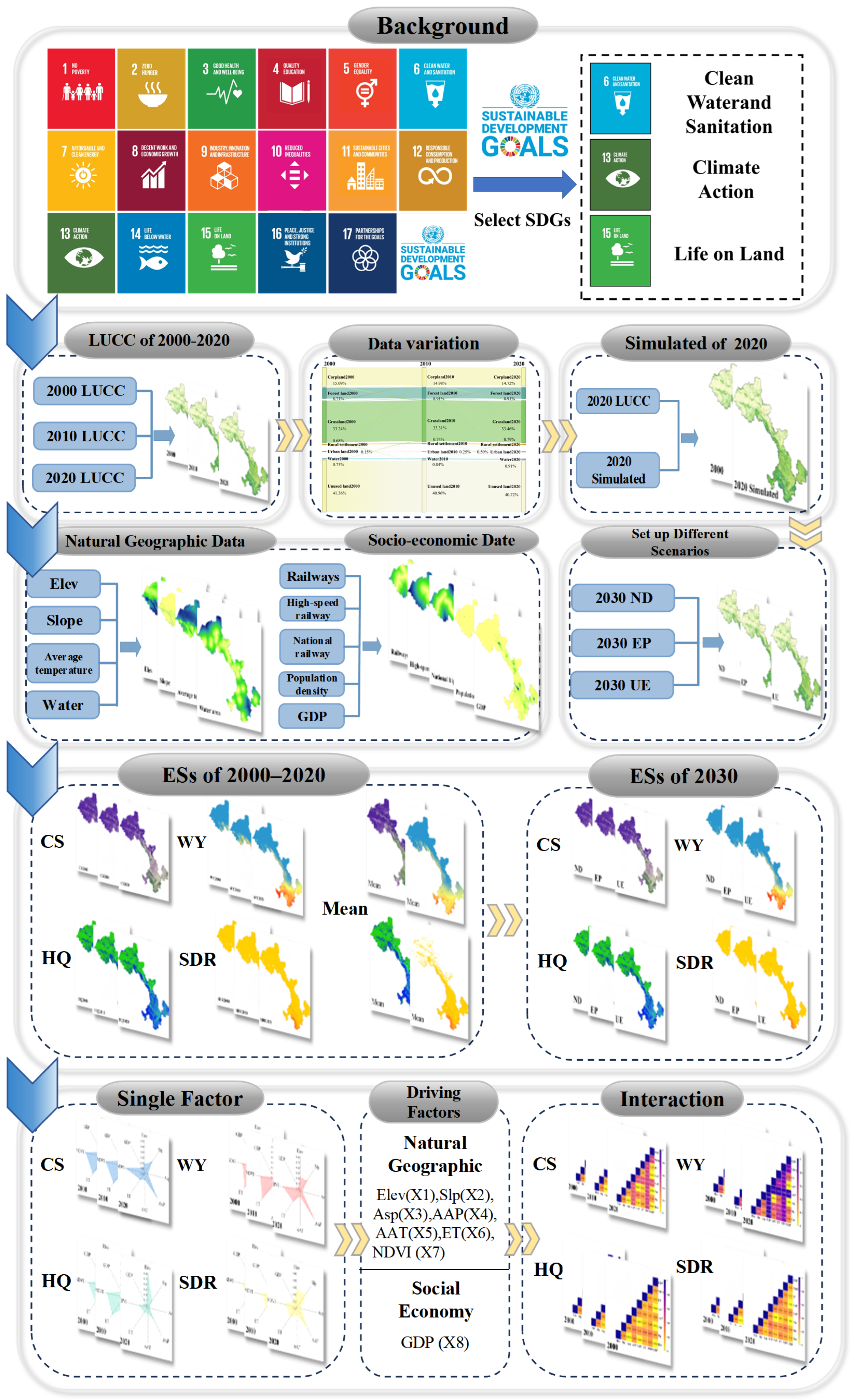
Impacts of Land-Use Change on the Spatiotemporal Dynamics and Driving Mechanisms of Ecosystem Services in Arid and Semi-Arid Regions: A Case Study of Gansu Province, China


Abstract
1. Introduction
2. Materials and Methods
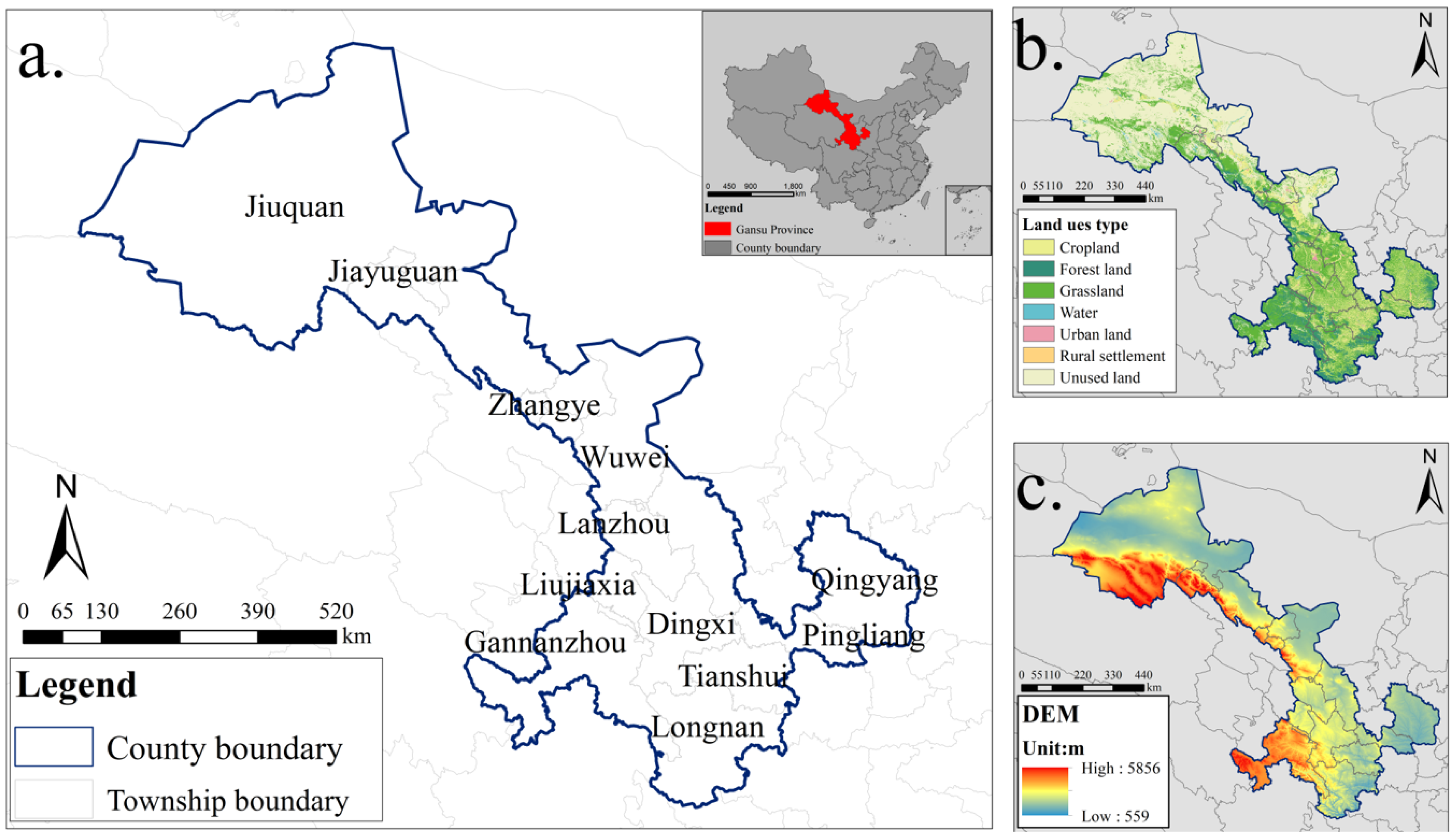
2.1. Overview of the Study Area
2.2. Data Sources
2.3. Research Methods
2.3.1. Land-Use Transition Matrix
2.3.2. Quantifying Ecosystem Services
- (1)
- Carbon Storage (CS)
- (2)
- Water Yield (WY)
- (3)
- Habitat Quality (HQ)
- (4)
- Soil Retention Service (SDR)
2.3.3. Quantitative Detection of Factors Influencing Spatiotemporal Patterns of Ecosystem Services
2.3.4. Multi-Scenario Land-Use Simulation
PLUS Model and Accuracy Validation
- (1)
- PLUS Model
- (2)
- Selection of Driving Factors
Setting Domain Weight Parameters
Scenario Design
Simulation Accuracy Assessment
3. Results
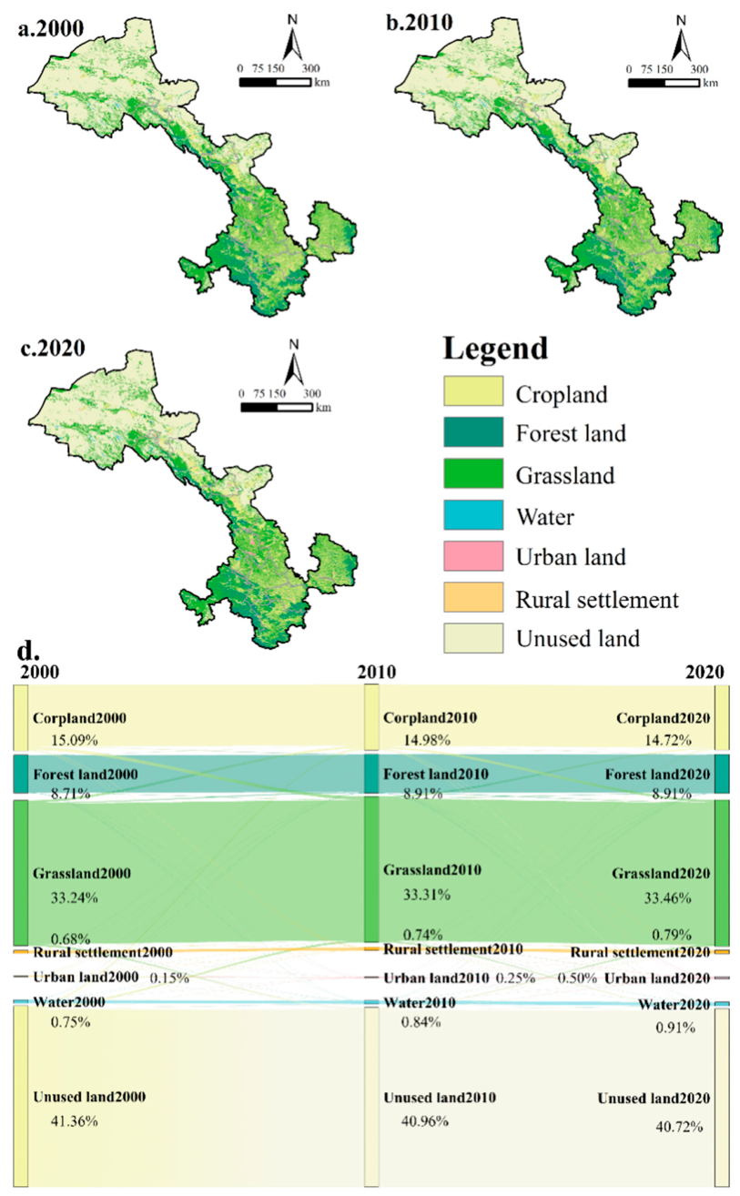
3.1. Land-Use Changes from 2000 to 2020
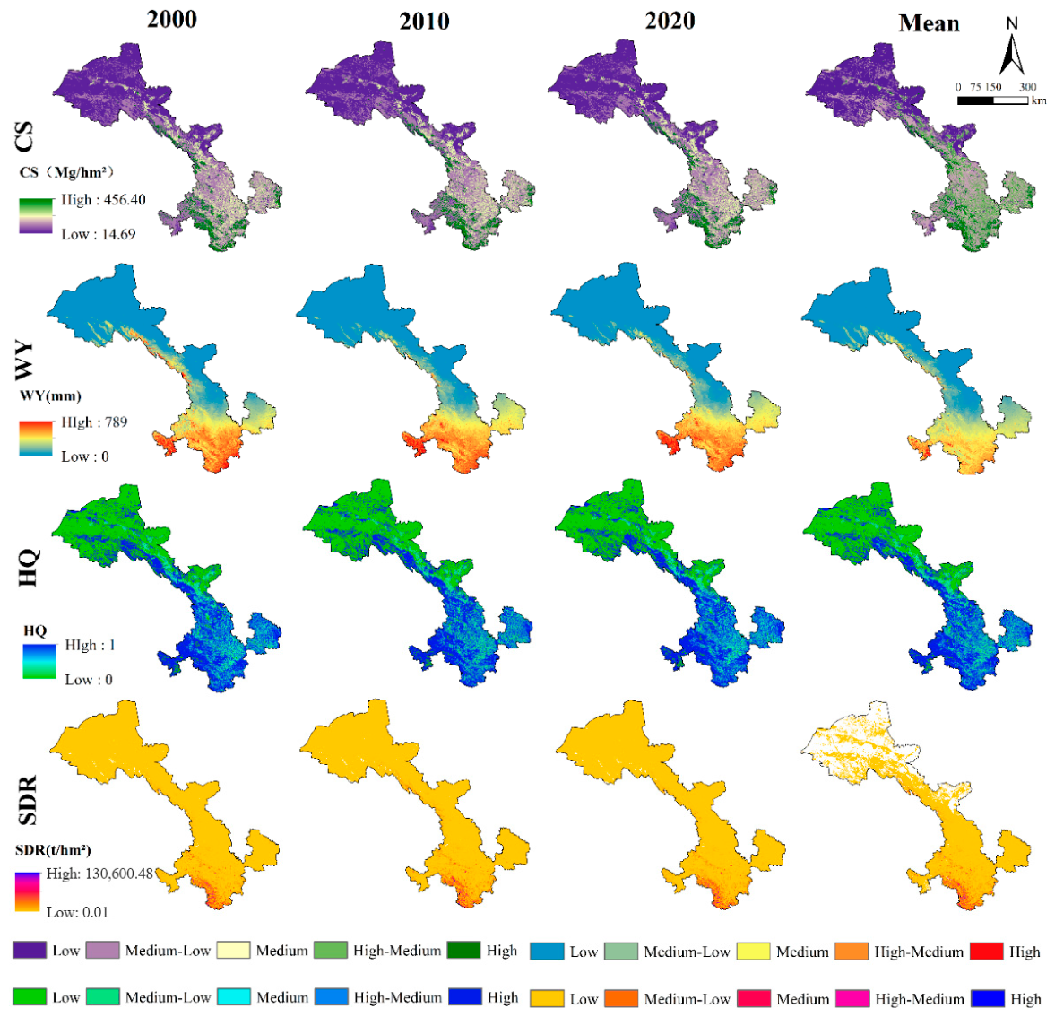
3.2. Spatiotemporal Patterns of Ecosystem Services from 2000 to 2020
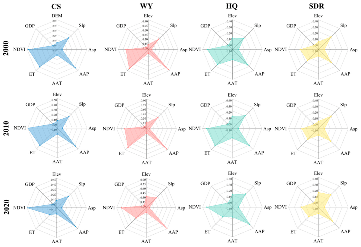
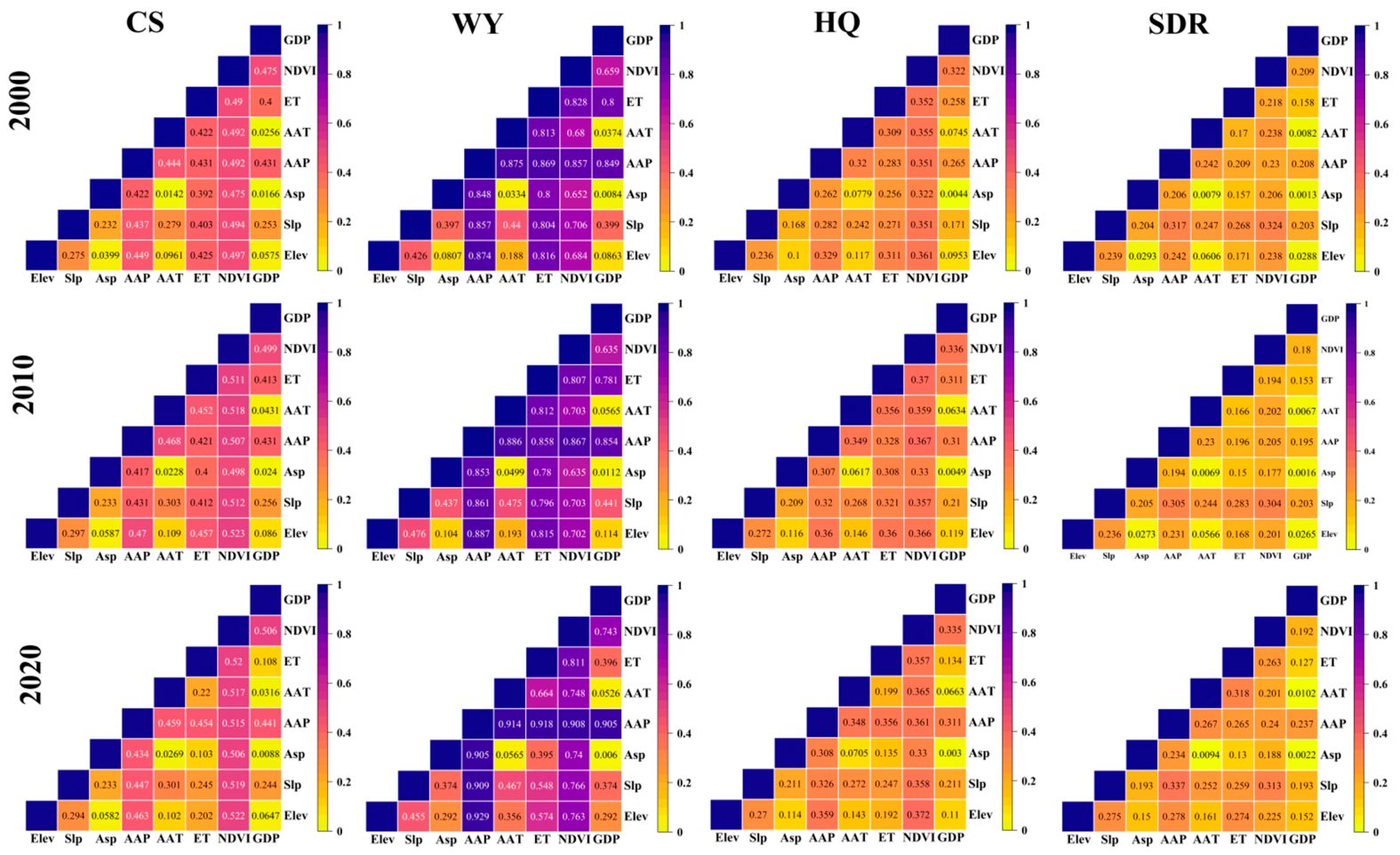
3.3. Impact of Driving Factors on Spatiotemporal Variations in Ecosystem Services
3.4. Land-Use Change Simulation and Evolution
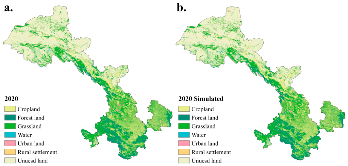
3.4.1. Validation of Simulation Accuracy and Assessment of Model Applicability
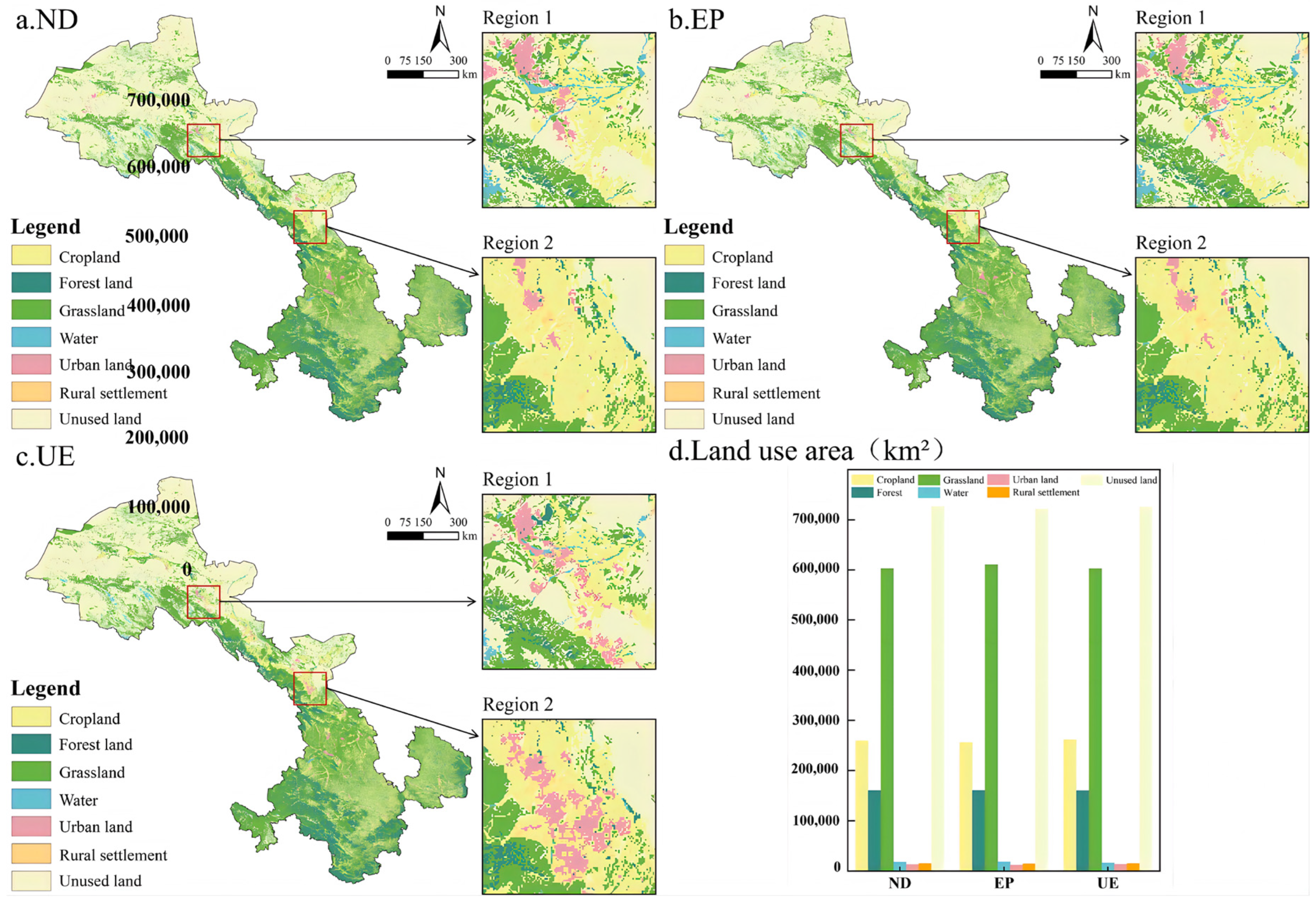
3.4.2. Characteristics of Land-Use Change Under Different Scenarios
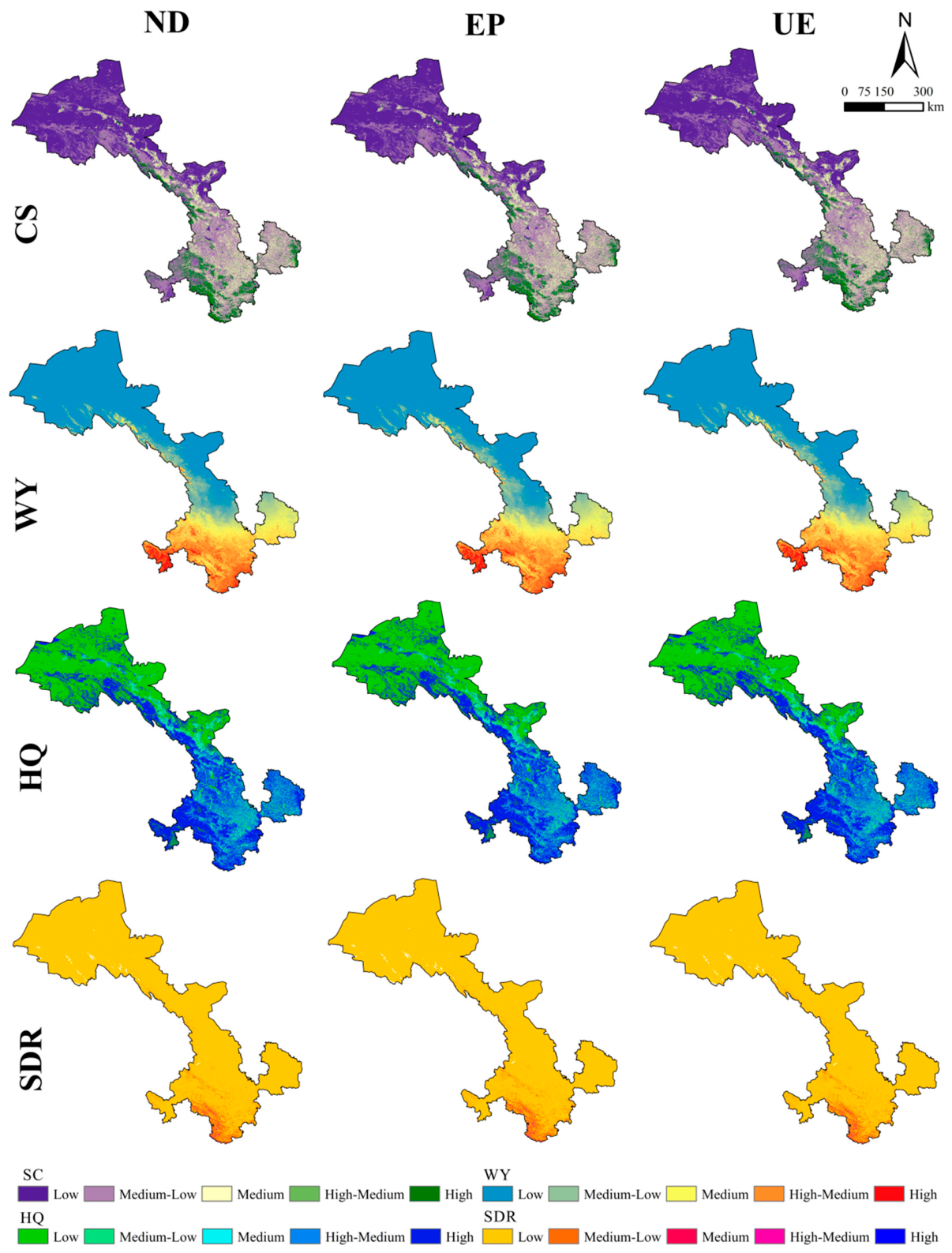
3.5. Characteristics of Ecosystem Service Variations Across Multiple Scenarios
4. Discussion
4.1. Land-Use Change and the Spatial Pattern of Ecosystem Services
4.2. Driving Mechanisms of Spatial Differentiation in Ecosystem Services
4.3. Policy Implications
4.4. Uncertainties and Methodological Limitations
5. Conclusions
Author Contributions
Funding
Data Availability Statement
Conflicts of Interest
Appendix A
Appendix A.1. The Calculation Formula of Carbon Storage
Appendix A.2. The Calculation Formula of Water Yield
Appendix A.3. The Calculation Formula of Habitat Quality
Appendix A.4. The Calculation Formula of Soil Retention Service

| Criterion | Interaction Type |
|---|---|
| q(X1∩X2) < Min(q(X1), q(X2)) | Nonlinear weakening |
| Min(q(X1), q(X2)) < q(X1∩X2) < Max(q(X1), q(X2)) | Single-factor nonlinear weakening |
| q(X1∩X2) > Max(q(X1), q(X2)) | Bi-factor enhancement |
| q(X1∩X2) = q(X1) + q(X2) | Independence |
| q(X1∩X2) < Min(q(X1), q(X2)) | Nonlinear enhancement |
| Cropland 2010 | Forest 2010 | Grassland 2010 | Water 2010 | Construction Land 2010 | Unused Land 2010 | |
|---|---|---|---|---|---|---|
| Cropland 2000 | 60,955.80 | 528.97 | 3130.76 | 41.68 | 668.60 | 256.66 |
| Forest 2000 | 230.45 | 37,053.2 | 280.67 | 23.70 | 30.48 | 76.11 |
| Grassland 2000 | 2184.55 | 915.39 | 137,834.71 | 60.23 | 139.00 | 1502.36 |
| Water 2000 | 49.57 | 6.72 | 45.81 | 3077.7 | 8.51 | 120.25 |
| Construction land 2000 | 222.89 | 8.91 | 27.98 | 1.84 | 3283.85 | 23.17 |
| Unused land 2000 | 1407.95 | 80.12 | 1627.51 | 348.26 | 180.72 | 169,098.9 |
| Cropland 2020 | Forest 2020 | Grassland 2020 | Water 2020 | Construction Land 2020 | Unused Land 2020 | |
|---|---|---|---|---|---|---|
| Cropland 2010 | 61,345.42 | 191.56 | 2282.85 | 61.73 | 747.89 | 418.00 |
| Forest 2010 | 129.09 | 37,771.0 | 582.68 | 15.04 | 48.22 | 40.16 |
| Grassland 2010 | 1596.01 | 485.27 | 139,339.56 | 69.95 | 337.96 | 1095.87 |
| Water 2010 | 32.46 | 9.71 | 49.99 | 3368.5 | 18.35 | 71.86 |
| Construction land 2010 | 188.43 | 12.03 | 74.63 | 5.83 | 3969.28 | 60.86 |
| Unused land 2010 | 580.59 | 87.52 | 1294.96 | 327.59 | 441.85 | 168,333.7 |
| CS (Mg/hm2) | WY (mm) | HQ | SDR (t/hm2) | |
|---|---|---|---|---|
| Low | 14.69–24.35 | 0.00–153.00 | 0–0.098 | 0.01–1659.09 |
| Medium–Low | 24.35–79.00 | 153.00–307.00 | 0.098–0.580 | 1659.09–5612.45 |
| Medium | 79.00–112.75 | 307.00–461.00 | 0.580–0.866 | 5612.45–12,240.20 |
| High–Medium | 112.75–248.60 | 307.00–461.00 | 0.866–0.964 | 12,240.20–23,243.86 |
| High | 248.60–456.40 | 615.00–798.00 | 1 | 23,243.86–130,600.48 |
| Cropland | Forest Land | Grassland | Water Area | Urban Land | Rural Settlement | Uused Land | Area in ND | |
|---|---|---|---|---|---|---|---|---|
| Cropland | 129.74 | 10.48 | 80.18 | 2.04 | 1.37 | 7.50 | 6.12 | 237.43 |
| Forest Land | 9.77 | 84.62 | 44.94 | 0.35 | 0.13 | 0.46 | 2.65 | 142.93 |
| Grassland | 78.53 | 44.66 | 365.8 | 2.45 | 0.92 | 3.07 | 41.83 | 537.29 |
| Water Area | 1.85 | 0.45 | 2.47 | 7.52 | 0.15 | 0.24 | 1.90 | 14.60 |
| Urban Land | 0.77 | 0.19 | 0.81 | 0.09 | 5.19 | 0.26 | 0.73 | 8.03 |
| Rural Settlement | 6.73 | 0.53 | 2.88 | 0.25 | 0.29 | 1.73 | 0.24 | 12.66 |
| Unused Land | 5.43 | 2.32 | 43.05 | 2.93 | 3.35 | 0.27 | 598.52 | 655.87 |
| Area under 2020 | 103.09 | 132.78 | 459.9 | 13.59 | 10.04 | 6.03 | 645.88 | 1371.38 |
| Cropland | Forest Land | Grassland | Water Area | Urban Land | Rural Settlement | Uused Land | Area in ND | |
|---|---|---|---|---|---|---|---|---|
| Cropland | 128.60 | 10.56 | 82.37 | 1.98 | 1.15 | 7.14 | 5.64 | 237.43 |
| Forest Land | 9.55 | 84.81 | 45.09 | 0.34 | 0.13 | 0.45 | 2.56 | 142.93 |
| Grassland | 76.16 | 44.83 | 369.1 | 2.43 | 0.83 | 2.97 | 40.90 | 537.29 |
| Water Area | 1.89 | 0.46 | 2.50 | 7.67 | 0.14 | 0.22 | 1.72 | 14.60 |
| Urban Land | 0.90 | 0.19 | 0.81 | 0.09 | 5.24 | 0.24 | 0.56 | 8.03 |
| Rural Settlement | 6.81 | 0.54 | 2.95 | 0.24 | 0.30 | 1.61 | 0.21 | 12.66 |
| Unused Land | 5.58 | 2.41 | 44.63 | 3.52 | 2.89 | 0.72 | 596.12 | 655.87 |
| Area under 2020 | 229.49 | 143.80 | 547.5 | 16.27 | 10.68 | 13.35 | 647.70 | 1608.8 |
| Cropland | Forest Land | Grassland | Water Area | Urban Land | Rural Settlement | Uused Land | Area in ND | |
|---|---|---|---|---|---|---|---|---|
| Cropland | 127.18 | 10.47 | 79.40 | 1.35 | 5.29 | 7.69 | 6.07 | 237.44 |
| Forest Land | 10.10 | 84.34 | 44.89 | 0.30 | 0.17 | 0.46 | 2.71 | 142.96 |
| Grassland | 81.65 | 44.83 | 362.3 | 2.40 | 0.71 | 2.93 | 42.48 | 537.35 |
| Water Area | 2.12 | 0.47 | 2.50 | 6.55 | 0.36 | 0.25 | 2.35 | 14.60 |
| Urban Land | 1.21 | 0.27 | 1.42 | 0.07 | 3.11 | 0.36 | 1.60 | 8.03 |
| Rural Settlement | 6.77 | 0.54 | 2.81 | 0.17 | 0.60 | 1.54 | 0.24 | 12.66 |
| Unused Land | 5.90 | 2.29 | 46.45 | 3.18 | 1.46 | 0.24 | 596.36 | 655.88 |
| Area under 2020 | 234.91 | 143.21 | 539.8 | 14.01 | 11.69 | 13.46 | 651.81 | 1608.9 |
References
- Mo, H.; Xiao, Z. A systematic review and synthesis of trade offs and synergies among watershed ecosystem services. Discov. Environ. 2026, 4, 27. [Google Scholar] [CrossRef] [Scilit]
- Study of Critical Environmental Problems. Man’s Impact on the Global Environment: Assessment and Recommendations for Action; MIT Press: Cambridge, MA, USA, 1970.
- Jorge, J.S.; Caliman, A. Brazil’s environmental rollback threatens global ecosystem services. Ecosyst. Serv. 2026, 77. [Google Scholar] [CrossRef] [Scilit]
- Wang, S.; Wang, S.; Smith, P. Quantifying impacts of onshore wind farms on ecosystem services at local and global scales. Renew. Sustain. Energy Rev. 2015, 52, 1424–1428. [Google Scholar] [CrossRef] [Scilit]
- Xiao, Q.; Hu, D.; Xiao, Y. Assessing changes in soil conservation ecosystem services and causal factors in the Three Gorges Reservoir region of China. J. Clean. Prod. 2017, 163, S172–S180. [Google Scholar] [CrossRef] [Scilit]
- Sun, G.; Li, W.; Zhang, B. Valuing the Main Forest Ecosystem Services for China’s Beibu Gulf Economic Zone: How to Make a Good Measurement of Biodiversity Maintenance? In Proceedings of the 2011 Asia-Pacific Power and Energy Engineering Conference, Wuhan, China, 25–28 March 2011; pp. 1–4. [Google Scholar] [CrossRef] [Scilit]
- Kanter, R.; Fort, M.P. Shared burdens, shared responsibilities: Advancing the 2030 Agenda for Sustainable Development. Lancet 2025, 406, 1703–1705. [Google Scholar] [CrossRef] [Scilit] [PubMed]
- Tharik, M.; Arumugam, K.; Vijayaraghavalu, S.S. Assessing natural and human-induced drivers of groundwater quality and health risks in coastal deltas: Advancing SDG 3, SDG 6, SDG 13, and SDG 15. Appl. Water Sci. 2025, 15, 313. [Google Scholar] [CrossRef] [Scilit]
- Chen, P.; Chu, Z.; Han, H. Responding to SDG13: Exploring the role of renewable energy in physical climate risk governance. Energy 2025, 338, 138983. [Google Scholar] [CrossRef] [Scilit]
- Fu, S.; Lei, J.; You, Y.; Zhou, N. Assessment of land degradation in the conventional lake Chad basin between 2001 and 2020 based on SDG 15.3. 1. Environ. Sustain. Indic. 2025, 28, 101002. [Google Scholar] [CrossRef] [Scilit]
- Cheng, Y.; Zhang, X.; Song, W. Ecological risk assessment of land use change in the Tarim River Basin, Xinjiang, China. Land 2024, 13, 561. [Google Scholar] [CrossRef] [Scilit]
- Zhao, Y.; Zhang, X.; Bai, Y.; Mi, F. Does land use change affect green space water use? An analysis of the Haihe River Basin. Forests 2019, 10, 545. [Google Scholar] [CrossRef] [Scilit]
- Liu, Y.; Huang, X.; Liu, Y. Detection of long-term land use and ecosystem services dynamics in the Loess Hilly-Gully region based on artificial intelligence and multiple models. J. Clean. Prod. 2024, 447, 141560. [Google Scholar] [CrossRef] [Scilit]
- Sheng, S.; Huang, J. Spatiotemporal dynamics and driving mechanisms of ecosystem services in the Beijing–Tianjin–Hebei urban agglomeration: Implications for sustainable land use planning. Land 2025, 14, 969. [Google Scholar] [CrossRef] [Scilit]
- Sokół, M.; Łaska, G. Biodiversity and ecosystem services: Complementary approach for catchment protection and land use in northeastern Poland. Ecol. Indic. 2024, 159, 111649. [Google Scholar] [CrossRef] [Scilit]
- Lungarska, A.; Chakir, R. Projections of climate change impacts on ecosystem services and the role of land use adaptation in France. Environ. Sustain. Indic. 2024, 22, 100369. [Google Scholar] [CrossRef] [Scilit]
- Xu, D.; Wu, F.; He, L.; Liu, H.; Jiang, Y. Impact of land use change on ecosystem services: Case study of the Zhangjiakou-Chengde area. Acta Ecol. Sin. 2019, 39, 7493–7501. [Google Scholar] [CrossRef] [Scilit]
- Winkler, K.J.; Viers, J.H.; Nicholas, K.A. Assessing ecosystem services and multifunctionality for vineyard systems. Front. Environ. Sci. 2017, 5, 15. [Google Scholar] [CrossRef] [Scilit]
- Menconi, M.; Palazzoni, L.; Grohmann, D. Core themes for an urban green systems thinker: A review of complexity management in provisioning cultural ecosystem services. Urban For. Urban Green. 2021, 65, 127355. [Google Scholar] [CrossRef] [Scilit]
- Pan, N.; Guan, Q.; Wang, Q.; Sun, Y.; Li, H.; Ma, Y. Spatial differentiation and driving mechanisms in ecosystem service value of arid region: A case study in the middle and lower reaches of Shule River Basin, NW China. J. Clean. Prod. 2021, 319, 128718. [Google Scholar] [CrossRef] [Scilit]
- Du, Z.; Ou, C.; An, Y.; Chen, J.; Meng, Y.; Chen, F. Analysis of Annual Spatiotemporal Variations in Carbon Stock in the Urban Agglomeration of the Middle Yangtze River Basin, China. Land 2024, 13, 2089. [Google Scholar] [CrossRef] [Scilit]
- Ma, J.; Jin, X.; Yin, X.; Liu, P.; Nie, Z. A new InVEST–genetic algorithm coupled water yield model: Application to water conservation function assessment in the Zhangjiakou-Chengde area. Ecol. Indic. 2025, 179, 114237. [Google Scholar] [CrossRef] [Scilit]
- Li, T.; Wang, X.; Jia, H. Evaluate water yield and soil conservation and their environmental gradient effects in fujian province in south China based on InVEST and geodetector models. Water 2025, 17, 230. [Google Scholar] [CrossRef] [Scilit]
- Li, X.; Liu, Z.; Li, S.; Li, Y. Multi-scenario simulation analysis of land use impacts on habitat quality in Tianjin based on the PLUS model coupled with the InVEST model. Sustainability 2022, 14, 6923. [Google Scholar] [CrossRef] [Scilit]
- Bagstad, K.J.; Semmens, D.J.; Winthrop, R.; Jaworksi, D.; Larson, J. Ecosystem Services Valuation to Support Decisionmaking on Public Lands—A Case Study of the San Pedro River Watershed, Arizona; US Geological Survey: Reston, VA, USA, 2012. [Google Scholar] [CrossRef] [Scilit]
- Sherrouse, B.C.; Clement, J.M.; Semmens, D.J. A GIS application for assessing, mapping, and quantifying the social values of ecosystem services. Appl. Geogr. 2011, 31, 748–760. [Google Scholar] [CrossRef] [Scilit]
- Sheng, S.; Lian, H. The spatial pattern evolution of rural settlements and multi-scenario simulations since the initiation of the reform and opening up policy in China. Land 2023, 12, 1763. [Google Scholar] [CrossRef] [Scilit]
- Shaoying, L.; Xiaoping, L.; Xia, L.; Yimin, C. Simulation model of land use dynamics and application: Progress and prospects. Natl. Remote Sens. Bull. 2021, 21, 329–340. [Google Scholar] [CrossRef] [Scilit]
- Hu, S.; Chen, L.; Li, L.; Zhang, T.; Yuan, L.; Cheng, L.; Wang, J.; Wen, M. Simulation of land use change and ecosystem service value dynamics under ecological constraints in Anhui Province, China. Int. J. Environ. Res. Public Health 2020, 17, 4228. [Google Scholar] [CrossRef] [Scilit] [PubMed]
- Zhu, K.; Li, S.; Huang, W.; Hou, P.; Liu, Y.; Liu, J.; Li, Z. Integrating the PLUS-InVEST Model to Project Water Conservation Dynamics and Decipher Climatic Drivers in the Chengdu–Chongqing Economic Zone Under Multiple Future Scenarios. Hydrology 2025, 12, 184. [Google Scholar] [CrossRef] [Scilit]
- Lei, J.; Liu, X.; Wang, L.; Li, X.; Ma, J.; Zhang, L.; Yang, H. Study on the relationship between intensive land use and ecosystem service value in Gansu Province. Ecol. Model. 2026, 511, 111379. [Google Scholar] [CrossRef] [Scilit]
- Bai, Y.; Han, C.; Tang, F.; Li, Z.; Tian, H.; Huang, Z.; Ma, L.; Hu, X.; Wang, J.; Chen, B. Potential Impacts of Land Use Change on Ecosystem Service Supply and Demand Under Different Scenarios in the Gansu Section of the Yellow River Basin, China. Remote Sens. 2025, 17, 489. [Google Scholar] [CrossRef] [Scilit]
- Li, X.; Yang, K.; Zhou, Y. Progress in the study of oasis-desert interactions. Agric. For. Meteorol. 2016, 230, 1–7. [Google Scholar] [CrossRef] [Scilit]
- Zhang, M.; Zhou, Y.; Li, X.; Sun, Z.; Yang, G.; Xie, Z. Quantifying the Contributions of Regional Human Activities and Global Climate Change to the Regional Climate in a Typical Mountain-Oasis-Desert System of Arid Central Asia from 1979 to 2018. J. Geophys. Res. Atmos. 2023, 128, e2022JD037110. [Google Scholar] [CrossRef] [Scilit]
- Xu, X.L.; Liu, J.Y.; Zhang, S.W.; Li, R.D.; Yan, C.Z.; Wu, S.X. China Multi-Temporal Land Use Remote Sensing Monitoring Data Set (CNLUCC); Resource and Environment Science Data Registration and Publication System: Beijing, China, 2018; Available online: https://www.resdc.cn/ (accessed on 10 June 2025).
- Dataset of Soil Conservation Capacity Preventing Water Erosion in China (1992–2019). Available online: https://www.scidb.cn/ (accessed on 10 June 2025).
- Resource and Environment Science Data Center. Provincial Digital Elevation Model (DEM) 30 m Data (SRTM 30 m); Resource and Environment Science Data Center: Beijing, China, 2005; Available online: https://www.resdc.cn/ (accessed on 10 June 2025).
- Peng, S.; Ding, Y.; Liu, W.; Li, Z. 1 km monthly temperature and precipitation dataset for China from 1901 to 2017. Earth Syst. Sci. Data 2019, 11, 1931–1946. [Google Scholar] [CrossRef] [Scilit]
- Peng, S. 1 km Monthly Potential Evapotranspiration Dataset for China (1901–2023); National Tibetan Plateau/Third Pole Environment Data Center: Beijing, China, 2022; Available online: https://data.tpdc.ac.cn/ (accessed on 10 June 2025).
- OpenStreetMap Contributors. Available online: https://www.openstreetmap.org/ (accessed on 10 June 2025).
- Yang, Y.; Fang, M.; Li, J.; Jiao, Y.; Zhang, L.; Shi, L. Study on the Spatial Evolution and Evolutionary Models of Rural Settlements in 25 Counties (Cities, Districts) along the Yellow River in Shandong Province. J. Life Sci. Agric 2024, 1, 11–16. [Google Scholar] [CrossRef] [Scilit]
- Cheng, M.-Y.; Ji, G.-X.; Huang, J.-C.; Geng, J.-X.; Li, L.; Lu, J. Multi-scenario land cover simulation and carbon stock assessment in Shaanxi province based on the PLUS-InVEST model. Huanjing Kexue 2025, 46, 5729–5740. [Google Scholar] [CrossRef] [Scilit]
- Guan, R.-J.; Chen, Y.-L.; Huang, X.-B.; Lian, W.-H.; Liu, X.-G. Multi-scenario Simulation of Land Use and Response of Ecosystem Services in Southern Jiangxi Province Based on PLUS-InVEST Model. Huanjing Kexue 2025, 46, 7270–7285. [Google Scholar] [CrossRef] [Scilit]
- Gao, Y.; Ma, L.; Liu, J.; Zhuang, Z.; Huang, Q.; Li, M. Constructing ecological networks based on habitat quality assessment: A case study of Changzhou, China. Sci. Rep. 2017, 7, 46073. [Google Scholar] [CrossRef] [Scilit] [PubMed]
- Abdelwahab, O.M.; Ricci, G.F.; Netti, A.M.; De Girolamo, A.M.; Gentile, F. Modeling the Effect of Nature-Based Solutions in Reducing Soil Erosion with InVEST® SDR: The Carapelle Case Study. Water 2025, 17, 3451. [Google Scholar] [CrossRef] [Scilit]
- Yang, L.; Liu, Y.; Liu, Y.; Liu, R. Spatial-temporal dynamics and drivers of ecosystem service interactions along the Yellow River area in Shaanxi Province. J. Clean. Prod. 2025, 496, 145095. [Google Scholar] [CrossRef] [Scilit]
- Liu, R.; Li, L.; Guo, L.; Jiao, L.; Wang, Y.; Cao, L.; Wang, Y. Multi-scenario simulation of ecological risk assessment based on ecosystem service values in the Beijing-Tianjin-Hebei region. Environ. Monit. Assess. 2022, 194, 434. [Google Scholar] [CrossRef] [Scilit]
- Shen, J.; Li, S.; Liu, L.; Liang, Z.; Wang, Y.; Wang, H.; Wu, S. Uncovering the relationships between ecosystem services and social-ecological drivers at different spatial scales in the Beijing-Tianjin-Hebei region. J. Clean. Prod. 2021, 290, 125193. [Google Scholar] [CrossRef] [Scilit]
- Li, H.; Song, W. Evolution of rural settlements in the Tongzhou District of Beijing under the new-type urbanization policies. Habitat Int. 2020, 101, 102198. [Google Scholar] [CrossRef] [Scilit]
- Zhang, S.; Yang, P.; Xia, J.; Wang, W.; Cai, W.; Chen, N.; Hu, S.; Luo, X.; Li, J.; Zhan, C. Land use/land cover prediction and analysis of the middle reaches of the Yangtze River under different scenarios. Sci. Total Environ. 2022, 833, 155238. [Google Scholar] [CrossRef] [Scilit]
- Chen, J.; Fu, H.; Chen, S. Multi-scenario simulation and assessment of ecosystem service value at the city level from the perspective of “production–living–ecological” spaces: A Case Study of Haikou, China. Land 2023, 12, 1021. [Google Scholar] [CrossRef] [Scilit]
- Duan, Z.; Lu, C.; Wang, X.; Tang, X.; Sheng, S. Spatiotemporal Evolution and Multi-Scenario Simulation of Rural Settlements in Liangzhou District: Evidence from an Oasis Region in the Arid Northwest. Land 2025, 14, 2397. [Google Scholar] [CrossRef] [Scilit]
- Zheng, Z.; Wang, J.; Ni, J.; Cui, Y.; Zhu, Q. Lacustrine Wetlands Landscape Simulation and Multi-Scenario Prediction Based on the Patch-Generating Land-Use Simulation Model: A Case Study on Shengjin Lake Reserve, China. Remote Sens. 2024, 16, 4169. [Google Scholar] [CrossRef] [Scilit]
- Gansu Province Territorial Space Planning (2021–2035). Available online: https://www.gsei.com.cn/ (accessed on 20 June 2025).
- Zhao, J.; Shao, Z.; Xia, C.; Fang, K.; Chen, R.; Zhou, J. Ecosystem services assessment based on land use simulation: A case study in the Heihe River Basin, China. Ecol. Indic. 2022, 143, 109402. [Google Scholar] [CrossRef] [Scilit]
- Zhu, G.; Qiu, D.; Zhang, Z.; Sang, L.; Liu, Y.; Wang, L.; Zhao, K.; Ma, H.; Xu, Y.; Wan, Q. Land-use changes lead to a decrease in carbon storage in arid region, China. Ecol. Indic. 2021, 127, 107770. [Google Scholar] [CrossRef] [Scilit]
- Li, Y.; Liu, W.; Feng, Q.; Zhu, M.; Yang, L.; Zhang, J.; Yin, X. The role of land use change in affecting ecosystem services and the ecological security pattern of the Hexi Regions, Northwest China. Sci. Total Environ. 2023, 855, 158940. [Google Scholar] [CrossRef] [Scilit] [PubMed]
- Yu, H.-X.; Tang, J.-L.; Chen, R.-Q. Spatiotemporal evolution characteristics and multi-scale spatial balance and matching analysis of ecosystem service supply and demand in Hubei Province. Huanjing Kexue 2024, 45, 6477–6488. [Google Scholar] [CrossRef] [Scilit] [PubMed]
- Gansu Province Territorial Space Ecological Restoration Plan (2021–2035). Available online: https://zrzy.gansu.gov.cn/ (accessed on 20 June 2025).
- Action Plan for Gansu Province to Fortify the National Ecological Security Barrier in the West. Available online: https://lslhzhb.lanzhou.gov.cn/ (accessed on 20 June 2025).
- Yellow River Basin Territorial Space Planning (2021–2035). Available online: https://www.gov.cn/ (accessed on 20 June 2025).
- Song, W.; Li, H. Spatial pattern evolution of rural settlements from 1961 to 2030 in Tongzhou District, China. Land Use Policy 2020, 99, 105044. [Google Scholar] [CrossRef] [Scilit]

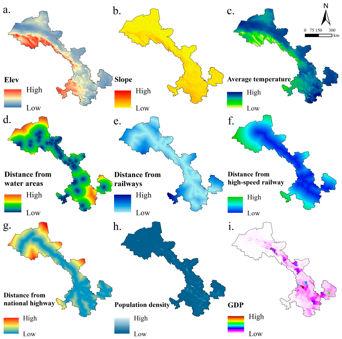



| Data | Time | Resolution | Data Sources |
|---|---|---|---|
| China National Land Use/Cover Change dataset, CNLUCC | 2000–2020 | 30·m | China Resources Environment Science and Data Center [35] |
| Soil Data Source | 2010 | 300 m | Dataset of Soil Conservation Capacity Preventing Water Erosion in China (1992–2019) [36] |
| DEM, Slope, Aspect | 2010 | 90 m | China Resources Environment Science and Data Center [37] |
| Mean annual precipitation | 2020 | 1000 m | National Tibetan Plateau Data Center (TPDC) [38] |
| Mean annual temperature | 2020 | 1000 m | China Resources Environment Science and Data Center [37] |
| Evaporation | 2010 | 1000 m | National Tibetan Plateau Data Center (TPDC) [39] |
| Normalized Difference Vegetation Index (NDVI) | 2010 | 1000 m | China Resources Environment Science and Data Center [37] |
| Water area | 2010 | — | OpenStreetMap [40] |
| GDP | 2025 | 1000 m | China Resources Environment Science and Data Center [37] |
| Population density | 2024 | 1000 m | China Resources Environment Science and Data Center [37] |
| Railway | — | OpenStreetMap [40] | |
| Highway | — | OpenStreetMap [40] | |
| High-speed railway | — | OpenStreetMap [40] |
| Cropland | Forest Land | Grassland | Water Area | Urban Land | Rural Settlement | Unuse Land | |
|---|---|---|---|---|---|---|---|
| Cropland | 0.92884 | 0.008186 | 0.047821 | 0.000758 | 0.003261 | 0.007103 | 0.00403 |
| Forest land | 0.006263 | 0.982522 | 0.007626 | 0.000723 | 0.000461 | 0.000256 | 0.00215 |
| Grassland | 0.015381 | 0.00647 | 0.966051 | 0.000388 | 0.000463 | 0.000485 | 0.010761 |
| Water area | 0.016037 | 0.001782 | 0.014754 | 0.928368 | 0.001924 | 0.000214 | 0.036921 |
| Urban land | 0.012355 | 0.002995 | 0.012355 | 0.000374 | 0.934856 | 0.002995 | 0.03407 |
| Rural settlement | 0.077613 | 0.002327 | 0.007146 | 0.000582 | 0.007811 | 0.903191 | 0.00133 |
| Other construction land | 0.008128 | 0.000462 | 0.009364 | 0.001973 | 0.000944 | 0.000107 | 0.979023 |
| Cropland | Forest Land | Grassland | Water Area | Urban Land | Rural Settlement | Unuse Land | |
|---|---|---|---|---|---|---|---|
| Cropland | 1 | 1 | 1 | 1 | 1 | 1 | 1 |
| Forest land | 1 | 1 | 1 | 1 | 1 | 1 | 1 |
| Grassland | 1 | 1 | 1 | 1 | 1 | 1 | 1 |
| Water area | 0 | 0 | 0 | 1 | 1 | 1 | 1 |
| Urban land | 1 | 1 | 1 | 1 | 1 | 1 | 1 |
| Rural settlement | 1 | 1 | 1 | 1 | 1 | 1 | 1 |
| Unused land | 1 | 1 | 1 | 1 | 1 | 1 | 1 |
| Cropland | Forest Land | Grassland | Water Area | Urban Land | Rural Settlement | Unuse Land | |
|---|---|---|---|---|---|---|---|
| Cropland | 1 | 1 | 1 | 1 | 1 | 1 | 1 |
| Forest land | 1 | 1 | 1 | 1 | 1 | 1 | 1 |
| Grassland | 1 | 1 | 1 | 1 | 1 | 1 | 1 |
| Water area | 0 | 0 | 0 | 1 | 1 | 1 | 1 |
| Urban land | 1 | 1 | 1 | 1 | 1 | 1 | 1 |
| Rural settlement | 1 | 1 | 1 | 1 | 1 | 1 | 1 |
| Unused land | 1 | 1 | 1 | 1 | 1 | 1 | 1 |
| Cropland | Forest Land | Grassland | Water Area | Urban Land | Rural Settlement | Unuse Land | |
|---|---|---|---|---|---|---|---|
| Cropland | 1 | 0 | 0 | 0 | 1 | 1 | 0 |
| Forest land | 1 | 1 | 1 | 1 | 1 | 1 | 0 |
| Grassland | 1 | 0 | 1 | 0 | 1 | 1 | 0 |
| Water area | 1 | 1 | 1 | 1 | 1 | 1 | 0 |
| Urban land | 0 | 0 | 0 | 0 | 1 | 0 | 0 |
| Rural settlement | 0 | 0 | 0 | 0 | 1 | 1 | 0 |
| Unused land | 1 | 1 | 1 | 1 | 1 | 1 | 1 |
Disclaimer/Publisher’s Note: The statements, opinions and data contained in all publications are solely those of the individual author(s) and contributor(s) and not of MDPI and/or the editor(s). MDPI and/or the editor(s) disclaim responsibility for any injury to people or property resulting from any ideas, methods, instructions or products referred to in the content. |
© 2026 by the authors. Licensee MDPI, Basel, Switzerland. This article is an open access article distributed under the terms and conditions of the Creative Commons Attribution (CC BY) license.
Share and Cite
Duan, Z.; Wang, X.; Tang, X.; Lu, C.; Sheng, S. Impacts of Land-Use Change on the Spatiotemporal Dynamics and Driving Mechanisms of Ecosystem Services in Arid and Semi-Arid Regions: A Case Study of Gansu Province, China. Land 2026, 15, 668. https://doi.org/10.3390/land15040668
Duan Z, Wang X, Tang X, Lu C, Sheng S. Impacts of Land-Use Change on the Spatiotemporal Dynamics and Driving Mechanisms of Ecosystem Services in Arid and Semi-Arid Regions: A Case Study of Gansu Province, China. Land. 2026; 15(4):668. https://doi.org/10.3390/land15040668
Chicago/Turabian StyleDuan, Zhuanghui, Xiyun Wang, Xianglong Tang, Chenyu Lu, and Shuangqing Sheng. 2026. "Impacts of Land-Use Change on the Spatiotemporal Dynamics and Driving Mechanisms of Ecosystem Services in Arid and Semi-Arid Regions: A Case Study of Gansu Province, China" Land 15, no. 4: 668. https://doi.org/10.3390/land15040668
APA StyleDuan, Z., Wang, X., Tang, X., Lu, C., & Sheng, S. (2026). Impacts of Land-Use Change on the Spatiotemporal Dynamics and Driving Mechanisms of Ecosystem Services in Arid and Semi-Arid Regions: A Case Study of Gansu Province, China. Land, 15(4), 668. https://doi.org/10.3390/land15040668