Towards Character-Based Zoning: Managing Historic Urban Landscapes and Integrating a Dynamic Integrity Framework in Jingdezhen, China


Abstract
1. Introduction
1.1. Theoretical Framework: From Static Preservation to Dynamic Integrity
1.2. Research Aim
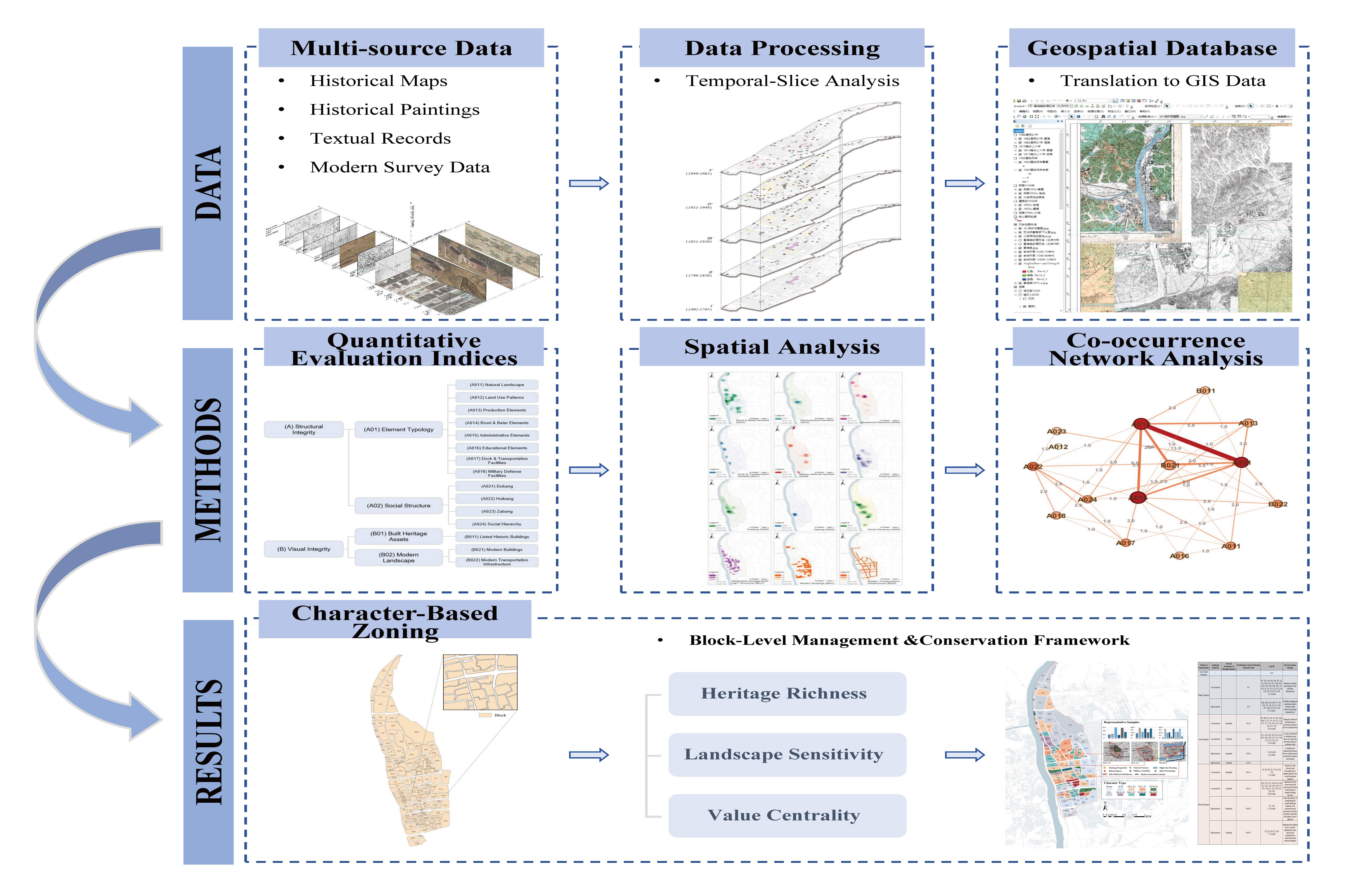
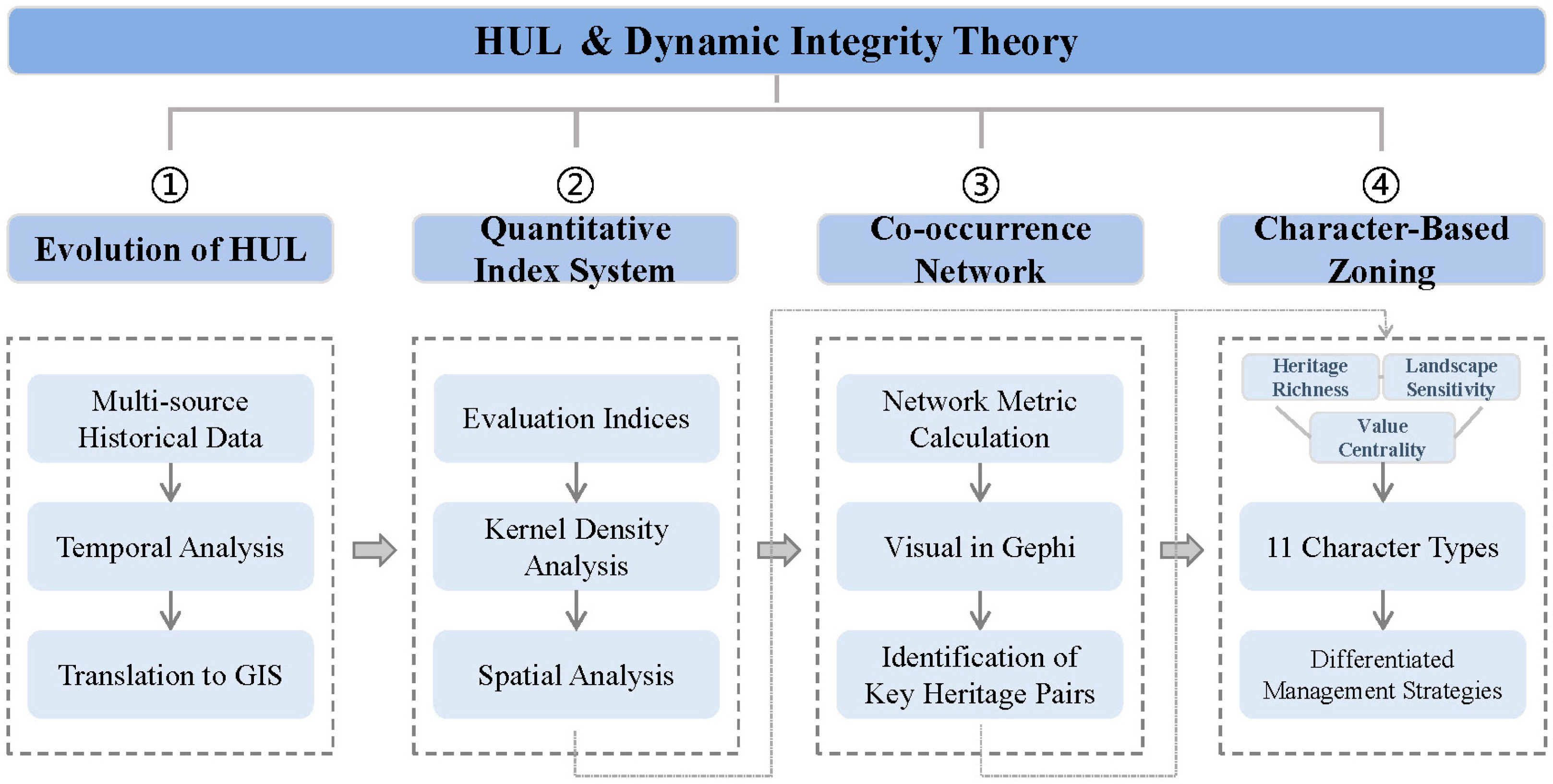
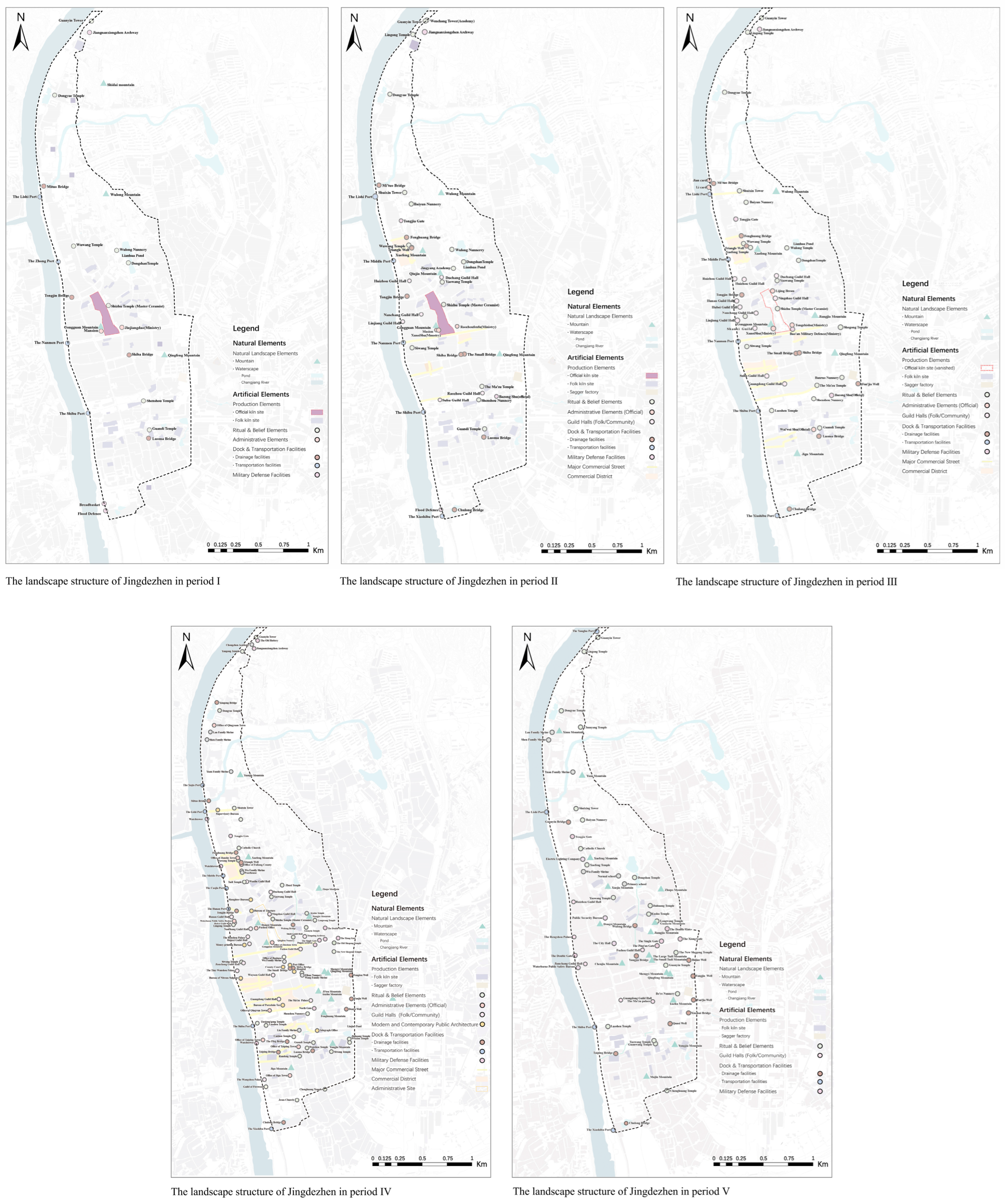
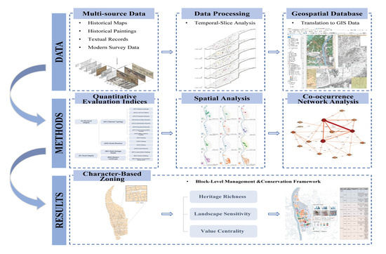
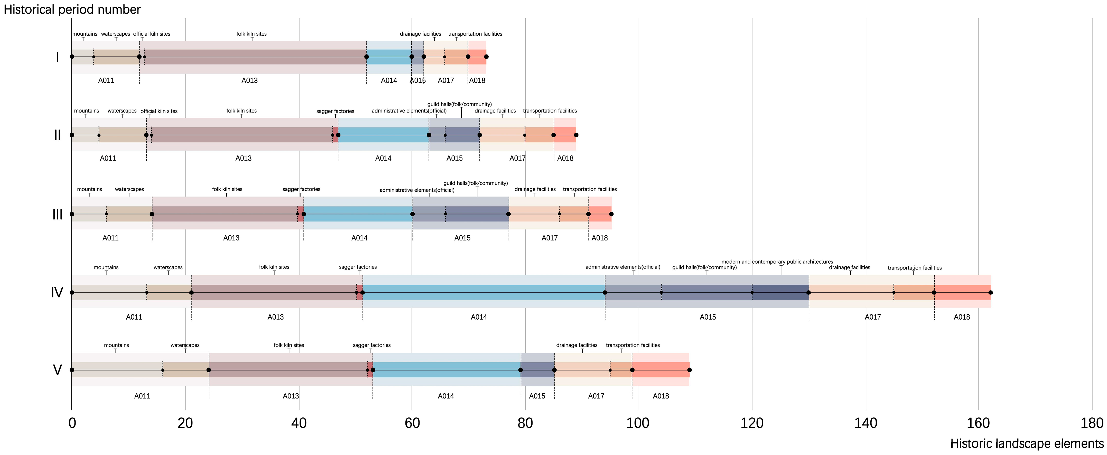
- To unravel the historical stratification and evolution of HUL: This objective involves a systematic examination of the spatio-temporal evolutionary trajectory of the Jingdezhen historic urban area, it aims to identify the specific stratification characteristics and evolutionary patterns distinct to various historical periods, thereby establishing a robust historical data foundation for the subsequent quantitative analysis.
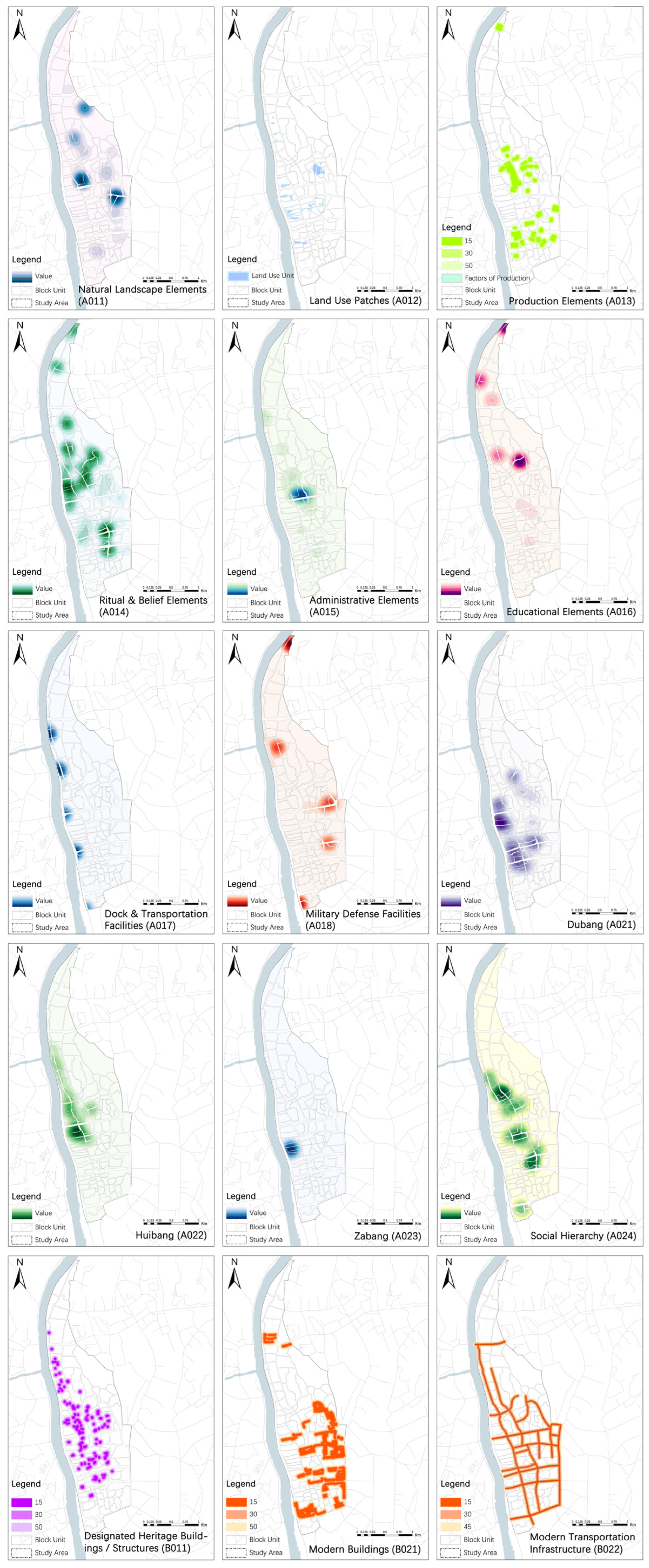
- To establish a quantitative index system: This objective involves integrating the theory of Dynamic Integrity into the HUL assessment framework to develop a multi-dimensional indicator system. It aims to facilitate a scientifically rigorous visual representation and quantitative interpretation of the complex HUL system.
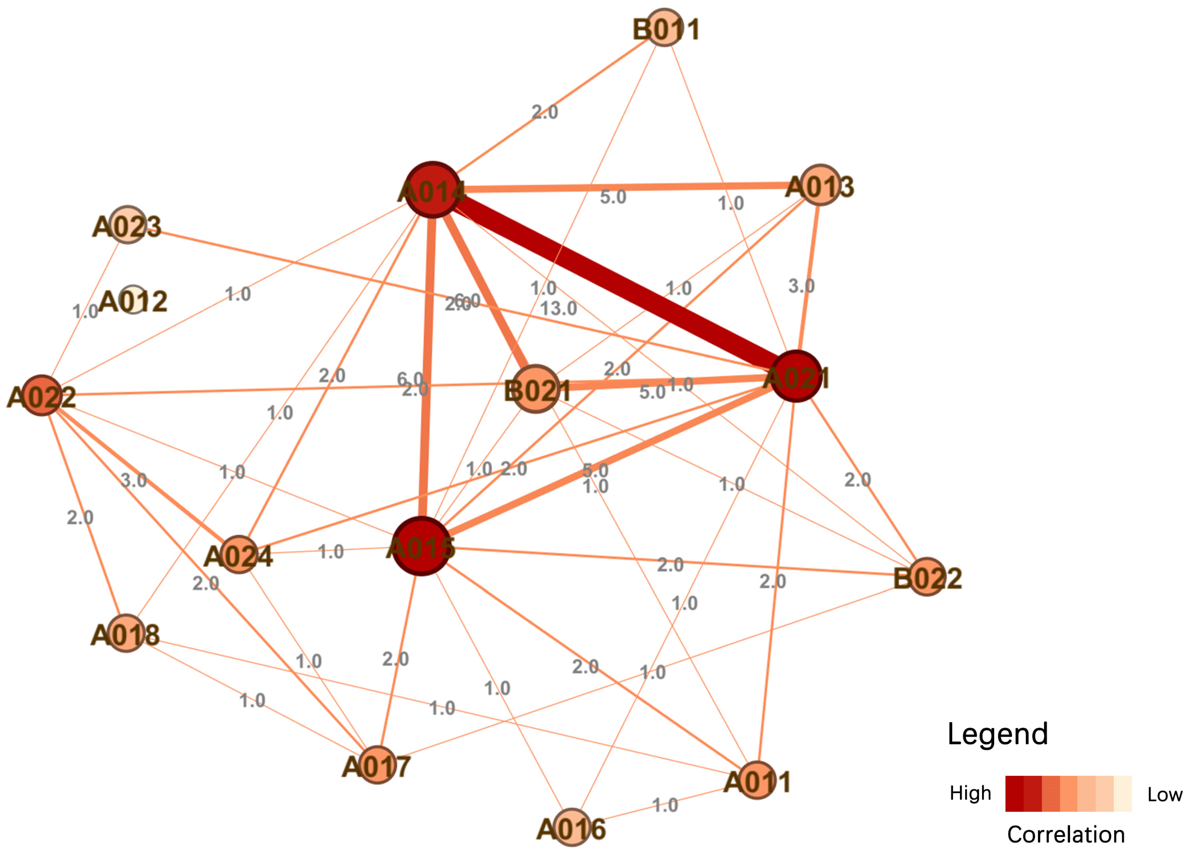
- To reveal the internal structural logic of the heritage system: By employing Co-occurrence Network Analysis, this study provides a methodological pathway to conduct an in-depth analysis of the mechanisms of association between diverse heritage elements. The goal is to synthesize their inherent structural characteristics and the underlying organizational patterns of the urban system.
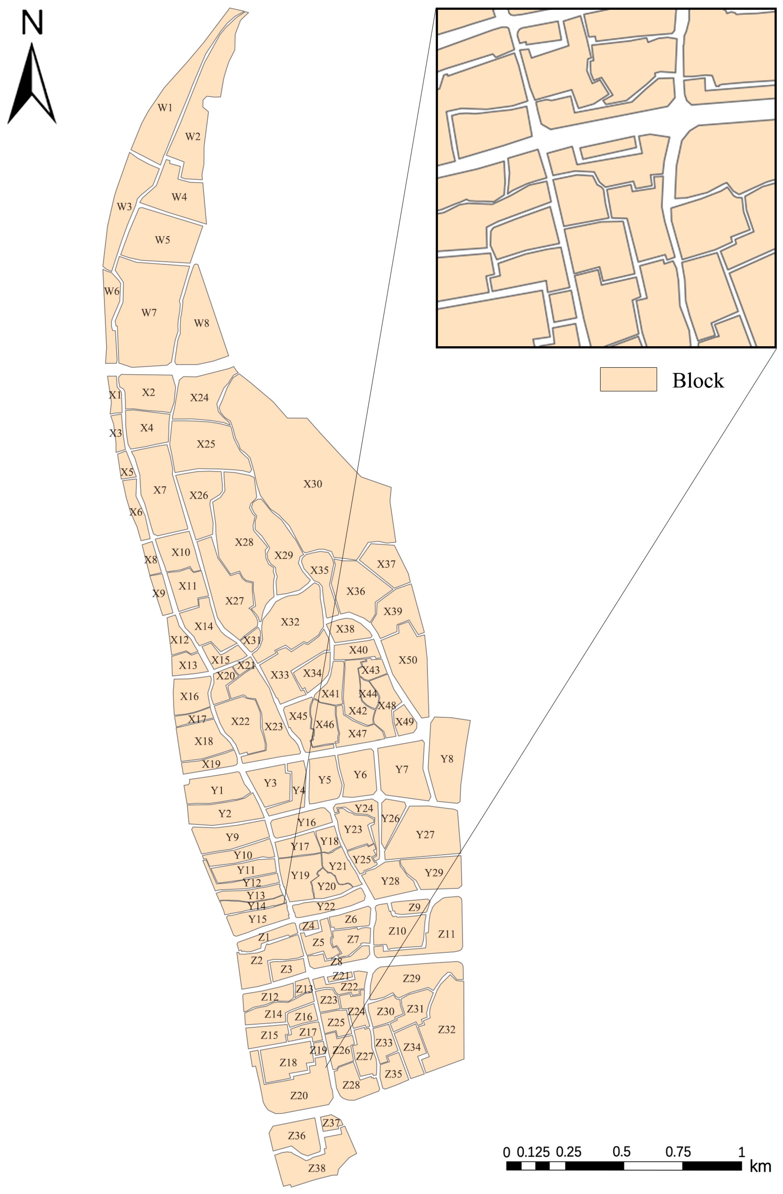
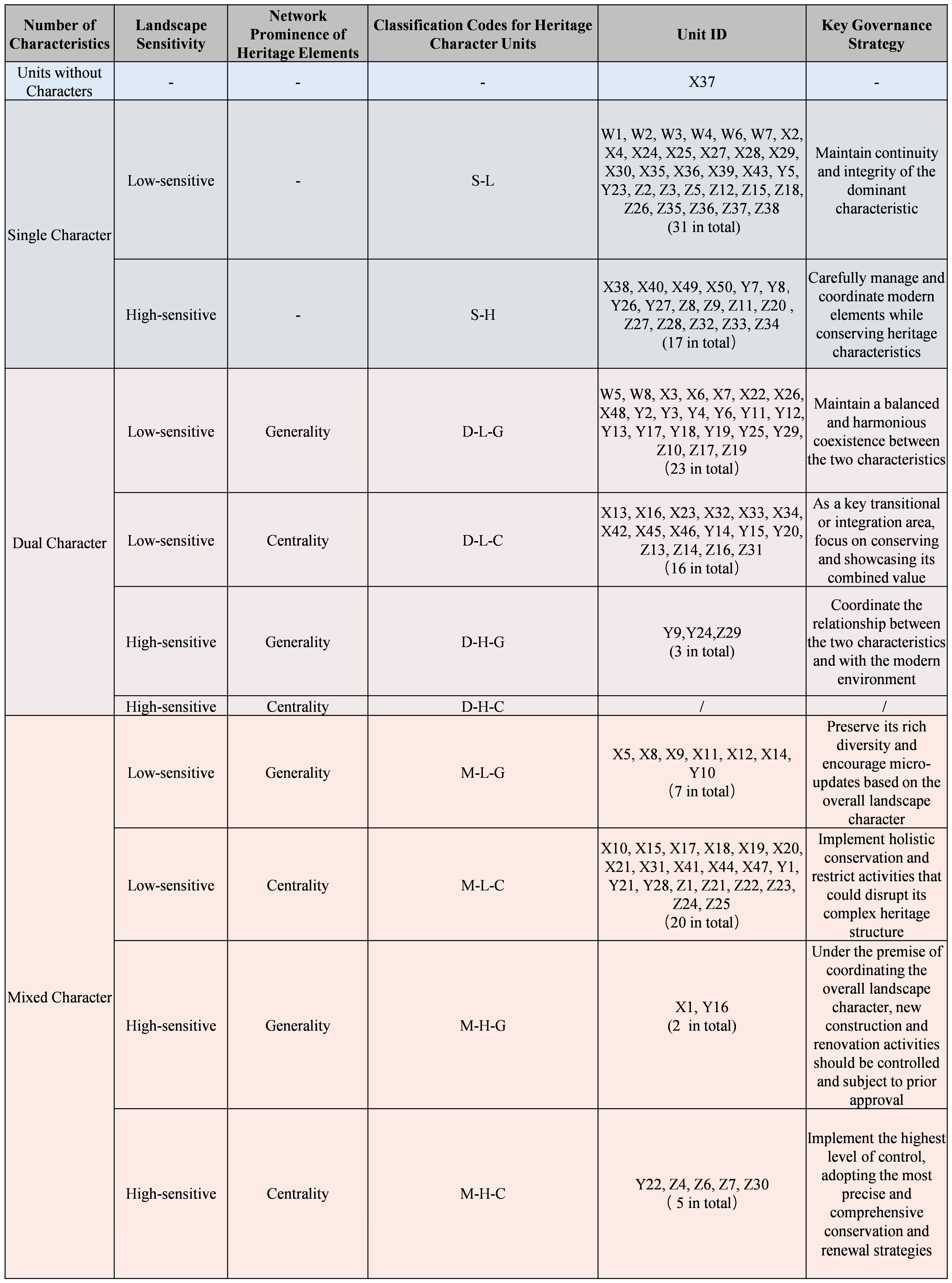
- To implement Character-Based Zoning and derive management strategies. Adopting the urban block as the fundamental spatial unit, this study conducts HUL character zoning based on the quantitative assessment results of Heritage Richness, Landscape Sensitivity, and Value Centrality. Consequently, it derives targeted planning strategies and conservation schemes specific to each identified character zone.
2. Materials and Methods
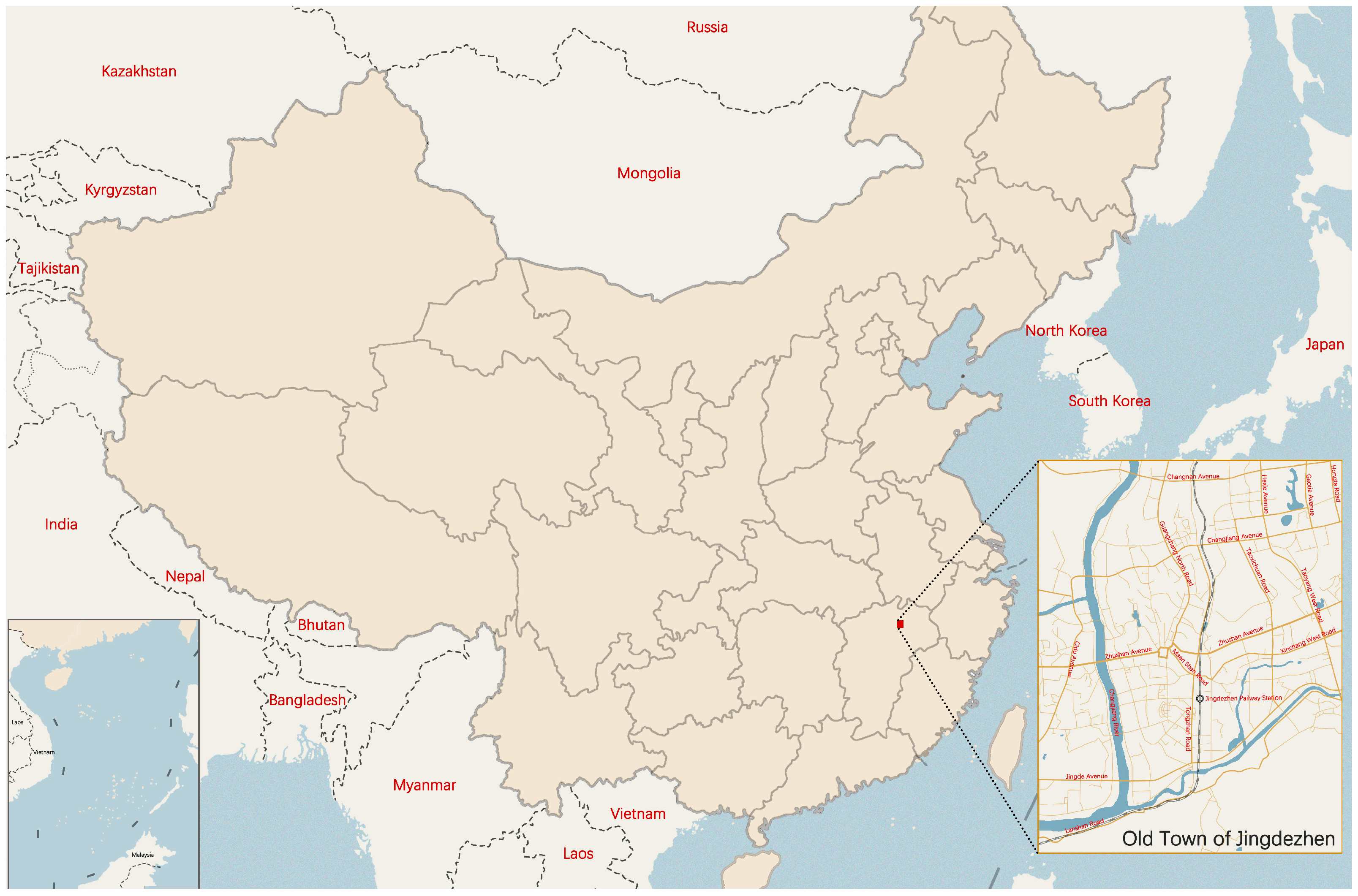
2.1. Study Area
2.2. Data Collection
2.3. Methodology
2.3.1. Historical Data Translation and Spatio-Temporal Mapping
- (1)
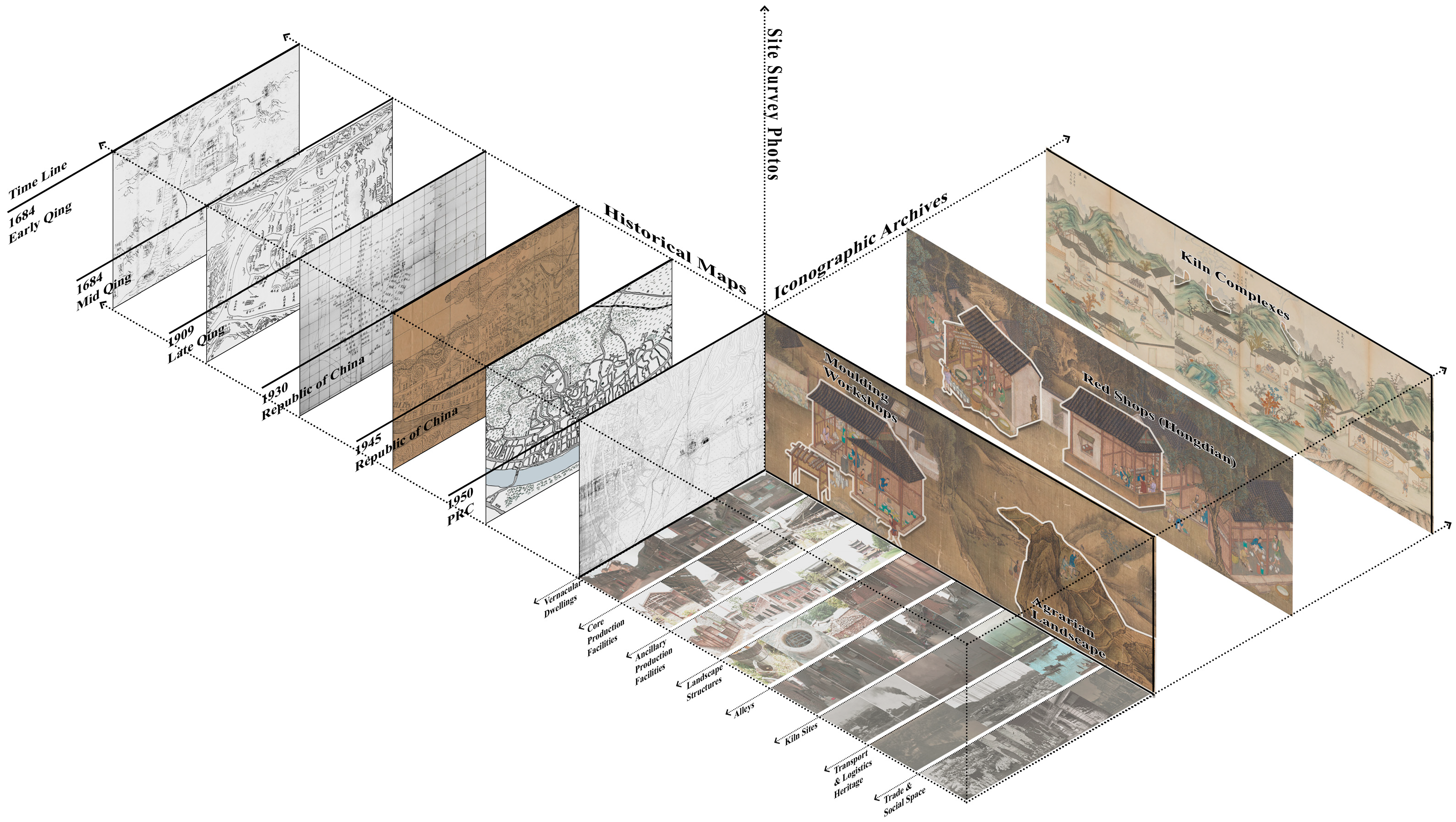
- Definition of Temporal Slices
- (2)
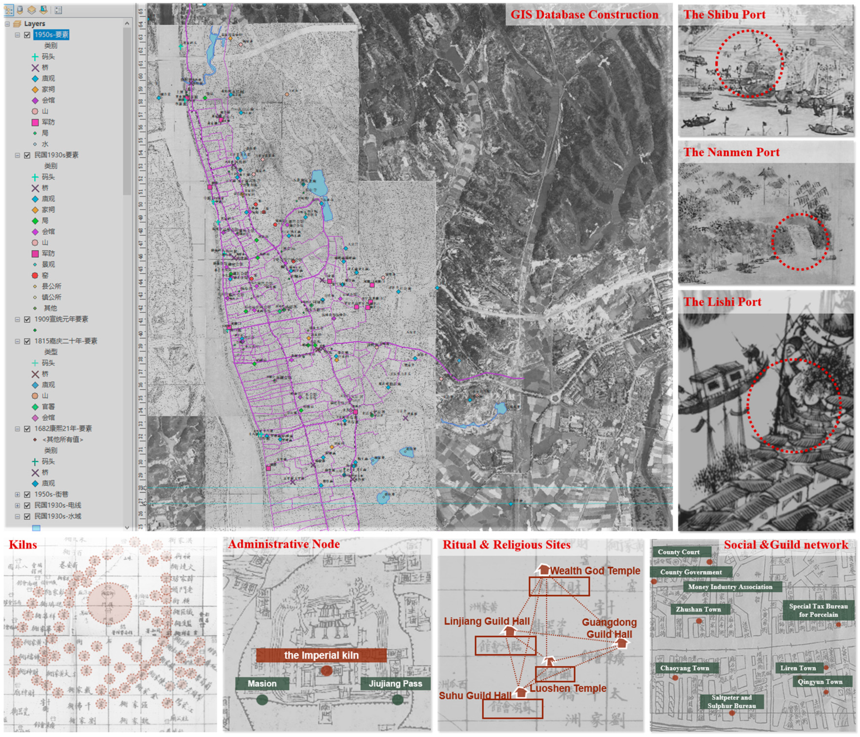
- Translation Process from Historical Information to GIS Data
- Source Compilation: Historical maps and textual descriptions were selected as primary sources for each period. Additionally, high-resolution aerial imagery from 2023 served as the base map for georeferencing. The CGCS2000 coordinate system was applied as the spatial reference.
- Spatial Georeferencing: Eight landmarks and road intersections were selected as ground control points (GCPs). Using the georeferencing tool in GIS, these points were matched between the early-modern maps and the 2023 aerial imagery. This process continued until the layers were accurately aligned (Table 2). Based on the continuity of historic urban fabric, core street networks, natural water systems, and key heritage elements remain spatially stable. Consequently, these georeferenced early-modern surveys serve as reliable spatial references. They enable the precise tracking and localization of ancient heritage sites, overcoming the inherent limitations of traditional maps in georeferencing. Vectorization and Reconstruction: Heritage elements identified from ancient historical records and maps were systematically converted into vector data. To ensure spatial accuracy, these ancient heritage points underwent a rigorous multi-source calibration process to align with modern geographic coordinates. Specifically, spatial information from historic maps was cross-validated with textual records (e.g., local gazetteers) and oral histories. This integration enabled the precise geolocalization of heritage elements.
- Database Construction: Finally, a diachronic geospatial database was established, stacking these five temporal layers to support the subsequent evaluation of heritage richness and dynamic integrity.
2.3.2. Construction of Quantitative Evaluation Indices
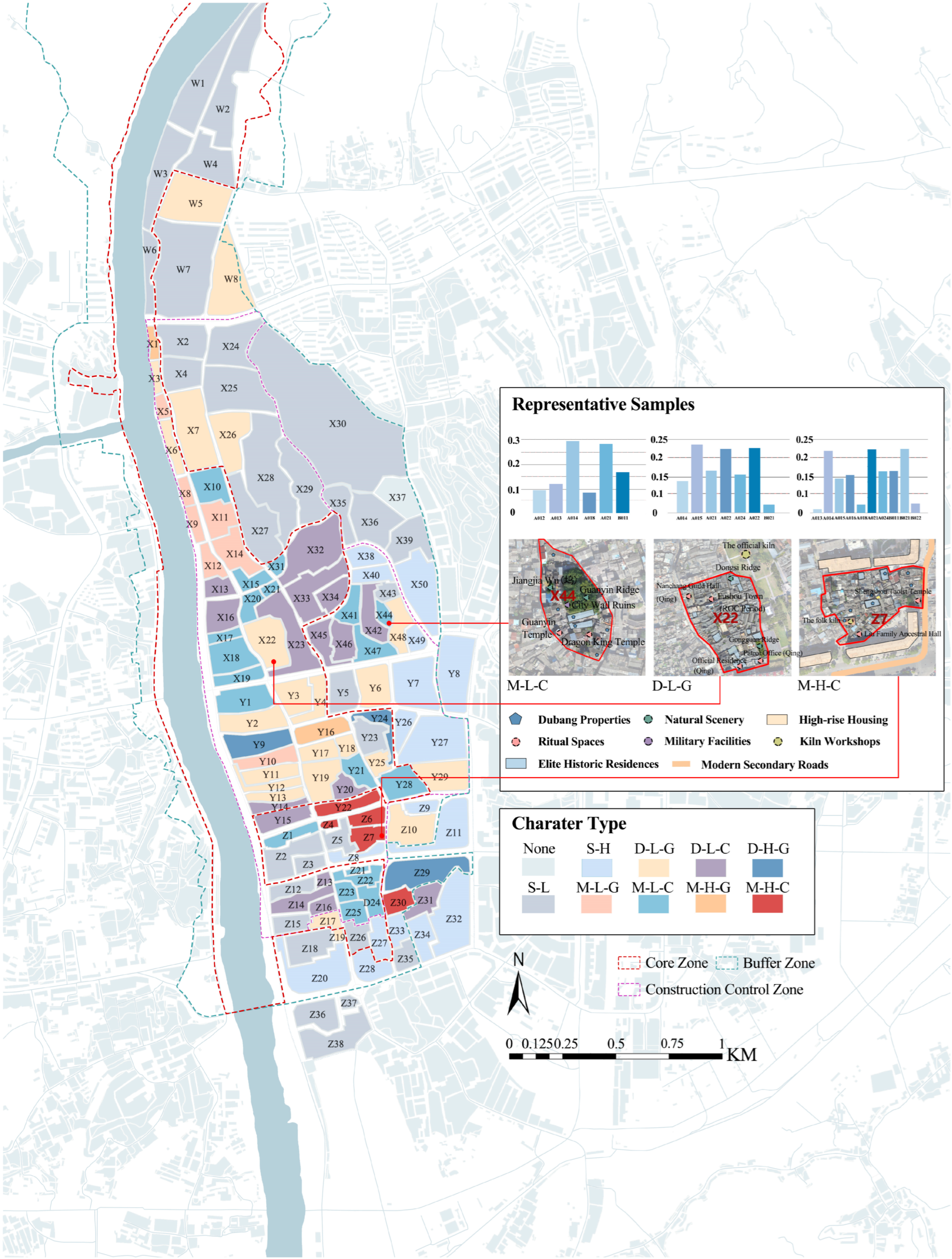
- Single-Character Zone: A unit is defined as a single-character zone if the relative contribution of a specific category is ≥50%, indicating a dominant heritage attribute.
- Dual-Character Zone: A unit is designated as a dual-character zone if no single category reaches 50%, but exactly two categories exhibit contribution ratios ranging between 20% and 50%.
- Mixed-Character Zone: A unit is classified as a mixed-character zone if no single category exceeds 50%, and three or more categories exhibit contribution ratios ≥ 20%.
- Null Zone: A unit is categorized as a null zone if the kernel density for all heritage categories is zero ( = 0).
2.3.3. Co-Occurrence Network Analysis Model
2.3.4. Character-Based Zoning and Classification Method
3. Results
3.1. Historical Stratification and Evolution of HUL
3.2. Quantitative Index System Integrating Dynamic Integrity
3.3. Internal Structural Logic of the Heritage System
3.4. Character-Based Zoning and Management Strategies
4. Discussion
4.1. Jingdezhen’s Dynamic Integrity: Patterns and Implications
4.2. Strategies for Heritage Conservation and Planning
4.3. Implications and Limitations of the Zoning Framework
5. Conclusions
Author Contributions
Funding
Data Availability Statement
Conflicts of Interest
Appendix A

| A011 | A012 | A013 | A014 | A015 | A016 | A017 | A018 | A021 | A022 | A023 | A024 | B011 | B021 | B022 | |
|---|---|---|---|---|---|---|---|---|---|---|---|---|---|---|---|
| A011 | 0.5 | 0.5 | 0.5 | 0.4 | 0.5 | 0.7 | 0.5 | 0.5 | 0.5 | 0.5 | 0.5 | 0.5 | 0.4 | 0.5 | 0.5 |
| A012 | 0.5 | 0.5 | 0.4 | 0.5 | 0.5 | 0.6 | 0.4 | 0.4 | 0.5 | 0.5 | 0.5 | 0.6 | 0.5 | 0.5 | 0.5 |
| A013 | 0.5 | 0.6 | 0.5 | 0.5 | 0.5 | 0.6 | 0.5 | 0.5 | 0.6 | 0.6 | 0.6 | 0.6 | 0.5 | 0.5 | 0.5 |
| A014 | 0.6 | 0.5 | 0.5 | 0.5 | 0.5 | 0.6 | 0.5 | 0.5 | 0.5 | 0.5 | 0.5 | 0.5 | 0.5 | 0.5 | 0.5 |
| A015 | 0.6 | 0.5 | 0.5 | 0.5 | 0.5 | 0.6 | 0.5 | 0.5 | 0.6 | 0.6 | 0.6 | 0.6 | 0.5 | 0.5 | 0.5 |
| A016 | 0.3 | 0.4 | 0.4 | 0.4 | 0.4 | 0.5 | 0.4 | 0.4 | 0.4 | 0.4 | 0.4 | 0.4 | 0.3 | 0.4 | 0.4 |
| A017 | 0.5 | 0.6 | 0.5 | 0.5 | 0.5 | 0.6 | 0.5 | 0.5 | 0.5 | 0.5 | 0.5 | 0.5 | 0.5 | 0.5 | 0.5 |
| A018 | 0.5 | 0.6 | 0.5 | 0.5 | 0.5 | 0.6 | 0.5 | 0.5 | 0.4 | 0.4 | 0.4 | 0.4 | 0.4 | 0.4 | 0.4 |
| A021 | 0.5 | 0.5 | 0.4 | 0.5 | 0.4 | 0.6 | 0.5 | 0.6 | 0.5 | 0.5 | 0.5 | 0.5 | 0.4 | 0.4 | 0.4 |
| A022 | 0.5 | 0.5 | 0.4 | 0.5 | 0.4 | 0.6 | 0.5 | 0.6 | 0.5 | 0.5 | 0.5 | 0.5 | 0.4 | 0.4 | 0.4 |
| A023 | 0.5 | 0.5 | 0.4 | 0.5 | 0.4 | 0.6 | 0.5 | 0.3 | 0.5 | 0.5 | 0.5 | 0.5 | 0.4 | 0.4 | 0.4 |
| A024 | 0.5 | 0.4 | 0.4 | 0.5 | 0.4 | 0.6 | 0.5 | 0.6 | 0.5 | 0.5 | 0.5 | 0.5 | 0.4 | 0.4 | 0.4 |
| B011 | 0.6 | 0.5 | 0.5 | 0.5 | 0.5 | 0.7 | 0.5 | 0.6 | 0.6 | 0.6 | 0.6 | 0.6 | 0.5 | 0.6 | 0.6 |
| B021 | 0.5 | 0.5 | 0.5 | 0.5 | 0.5 | 0.6 | 0.5 | 0.6 | 0.6 | 0.6 | 0.6 | 0.6 | 0.4 | 0.5 | 0.6 |
| B022 | 0.5 | 0.5 | 0.5 | 0.5 | 0.5 | 0.6 | 0.5 | 0.6 | 0.6 | 0.6 | 0.6 | 0.6 | 0.4 | 0.4 | 0.5 |
| A011 | A012 | A013 | A014 | A015 | A016 | A017 | A018 | A021 | A022 | A023 | A024 | B011 | B021 | B022 | |
|---|---|---|---|---|---|---|---|---|---|---|---|---|---|---|---|
| A011 | 0.5 | 0.5018 | 0.4895 | 0.4965 | 0.4912 | 0.5303 | 0.4965 | 0.5091 | 0.5054 | 0.5054 | 0.5054 | 0.5072 | 0.4828 | 0.4895 | 0.4930 |
| A012 | 0.4982 | 0.5 | 0.4877 | 0.4947 | 0.4894 | 0.5285 | 0.4947 | 0.5073 | 0.5036 | 0.5036 | 0.5036 | 0.5055 | 0.4810 | 0.4877 | 0.4912 |
| A013 | 0.5105 | 0.5123 | 0.5 | 0.5069 | 0.5017 | 0.5407 | 0.5069 | 0.5196 | 0.5159 | 0.5159 | 0.5159 | 0.5177 | 0.4932 | 0.5000 | 0.5034 |
| A014 | 0.5035 | 0.5053 | 0.4931 | 0.5 | 0.4948 | 0.5338 | 0.5000 | 0.5126 | 0.5090 | 0.5090 | 0.5090 | 0.5108 | 0.4863 | 0.4931 | 0.4965 |
| A015 | 0.5088 | 0.5106 | 0.4983 | 0.5052 | 0.5 | 0.5390 | 0.5052 | 0.5179 | 0.5142 | 0.5142 | 0.5142 | 0.5160 | 0.4915 | 0.4983 | 0.5017 |
| A016 | 0.4697 | 0.4715 | 0.4593 | 0.4662 | 0.4610 | 0.5 | 0.4662 | 0.4788 | 0.4751 | 0.4751 | 0.4751 | 0.4769 | 0.4526 | 0.4593 | 0.4627 |
| A017 | 0.5035 | 0.5053 | 0.4931 | 0.5000 | 0.4948 | 0.5338 | 0.5 | 0.5126 | 0.5090 | 0.5090 | 0.5090 | 0.5108 | 0.4863 | 0.4931 | 0.4965 |
| A018 | 0.4909 | 0.4927 | 0.4804 | 0.4874 | 0.4821 | 0.5212 | 0.4874 | 0.5 | 0.4963 | 0.4963 | 0.4963 | 0.4982 | 0.4737 | 0.4804 | 0.4839 |
| A021 | 0.4946 | 0.4964 | 0.4841 | 0.4910 | 0.4858 | 0.5249 | 0.4910 | 0.5037 | 0.5 | 0.5000 | 0.5000 | 0.5018 | 0.4774 | 0.4841 | 0.4875 |
| A022 | 0.4946 | 0.4964 | 0.4841 | 0.4910 | 0.4858 | 0.5249 | 0.4910 | 0.5037 | 0.5000 | 0.5 | 0.5000 | 0.5018 | 0.4774 | 0.4841 | 0.4875 |
| A023 | 0.4946 | 0.4964 | 0.4841 | 0.4910 | 0.4858 | 0.5249 | 0.4910 | 0.5037 | 0.5000 | 0.5000 | 0.5 | 0.5018 | 0.4774 | 0.4841 | 0.4875 |
| A024 | 0.4928 | 0.4945 | 0.4823 | 0.4892 | 0.4840 | 0.5231 | 0.4892 | 0.5018 | 0.4982 | 0.4982 | 0.4982 | 0.5 | 0.4755 | 0.4823 | 0.4857 |
| B011 | 0.5172 | 0.5190 | 0.5068 | 0.5137 | 0.5085 | 0.5474 | 0.5137 | 0.5263 | 0.5226 | 0.5226 | 0.5226 | 0.5245 | 0.5 | 0.5068 | 0.5102 |
| B021 | 0.5105 | 0.5123 | 0.5000 | 0.5069 | 0.5017 | 0.5407 | 0.5069 | 0.5196 | 0.5159 | 0.5159 | 0.5159 | 0.5177 | 0.4932 | 0.5 | 0.5034 |
| B022 | 0.5070 | 0.5088 | 0.4966 | 0.5035 | 0.4983 | 0.5373 | 0.5035 | 0.5161 | 0.5125 | 0.5125 | 0.5125 | 0.5143 | 0.4898 | 0.4966 | 0.5 |
References
- Hanif, A.; Zakiri, J.A.; Mirzahi, S.; Asim, G.M.; Nadeem, G.F. Analysis of contextual factors influencing the development of unplanned settlements: The case of Herat City, Afghanistan. City Cult. Soc. 2024, 39, 100607. [Google Scholar] [CrossRef] [Scilit]
- Ginzarly, M.; Houbart, C.; Teller, J. The Historic Urban Landscape approach to urban management: A systematic review. Int. J. Herit. Stud. 2018, 25, 999–1019. [Google Scholar] [CrossRef] [Scilit]
- Pereira Roders, A.; Van Oers, R. Wedding cultural heritage and sustainable development: Three years after. J. Cult. Herit. Manag. Sustain. Dev. 2014, 4, 2–15. [Google Scholar] [CrossRef] [Scilit]
- Ripp, M.; Gustafsson, C.; Jones, Z.; Majumdar, S.; Ginzarly, M. Historic Urban Landscapes and Heritage Systems as the Basis for Sustainable Urban Development. Land 2025, 14, 1783. [Google Scholar] [CrossRef] [Scilit]
- Shan, C.; Yang, R.; Feng, J. A Study on the Spatial Narrative of Historical Urban Landscape Based on Water–Land Symbiosis: The Case of Suzhou Ancient City in China. Land 2025, 14, 2413. [Google Scholar] [CrossRef] [Scilit]
- Li, X.; Zhang, Y. Urban Morphology and Historical Urban Landscape Conservation and Management. In Conserving and Managing Historical Urban Landscape: An Integrated Morphological Approach; Li, X., Zhang, Y., Eds.; Springer Nature: Singapore, 2022; pp. 7–32. [Google Scholar]
- Cai, R.; Nasu, S. Adopting the ‘historic layering’ concept from the Historic Urban Landscape approach as a methodological framework for urban heritage conservation. Int. J. Herit. Stud. 2025, 31, 573–591. [Google Scholar] [CrossRef] [Scilit]
- Wang, Y.; Jin, C.; Xu, D.; Wang, T.; Wang, B. Analysis of Multi-Dimensional Layers in Historic Districts Based on Theory of the Historic Urban Landscape: Taking Shenyang Fangcheng as an Example. Land 2024, 13, 1736. [Google Scholar] [CrossRef] [Scilit]
- De Rosa, F.; Di Palma, M. Historic Urban Landscape Approach and Port Cities Regeneration: Naples between Identity and Outlook. Sustainability 2013, 5, 4268–4287. [Google Scholar] [CrossRef] [Scilit]
- Colavitti, A.M.; Floris, A.; Serra, S. Challenges and Opportunities for the Historic Urban Landscape Planning. The Sardinia Region Case Study. In Computational Science and Its Applications–ICCSA 2020; Springer: Cham, Switzerland, 2020; Volume 12255, pp. 407–421. [Google Scholar]
- Höftberger, K. Conservation and development: Implementation of the historic urban landscape approach in Khiva, Uzbekistan. Int. J. Herit. Stud. 2023, 29, 314–328. [Google Scholar] [CrossRef] [Scilit]
- Bahrami, B.; Samani, F.A.E. Reconnecting the Landscape in Historical Cities, Conceptual Analysis of Historic Urban Landscape Approach in Iran. Curr. World Environ. 2015, 10, 456–466. [Google Scholar] [CrossRef] [Scilit]
- Sun, J.; Shao, L. Interpretation of Historic Urban Landscape Genes: A Case Study of Harbin, China. Land 2024, 13, 1988. [Google Scholar] [CrossRef] [Scilit]
- Pei, Y.; Yang, R.; Dang, A. Interpretation of the Historic Layering Process and Value Assessment of Yulin Ancient City Based on the Historic Urban Landscape Approach. Urban Dev. Stud. 2022, 29, 128–136. [Google Scholar]
- Wang, Y.; Jin, C.; Wang, T.; Xu, D. The Interpretation of Historical Layer Evolution Laws in Historic Districts from the Perspective of the Historic Urban Landscape: A Case Study in Shenyang, China. Land 2025, 14, 1029. [Google Scholar] [CrossRef] [Scilit]
- He, D.; Yuan, L.; Chen, W. The connections between Historic Urban Landscape layers in Jingdezhen, the porcelain capital of China. Landsc. Res. 2023, 49, 393–409. [Google Scholar] [CrossRef] [Scilit]
- Liu, P. Fine-Grained Land-Use Zoning: A Patch-Based Spatial Repair Strategy for Historic Urban Areas. Urban Plan. Forum 2018, 106–113. [Google Scholar] [CrossRef]
- Dong, Y.; Han, D. Land Parcel Classification in the Practice of Historic Site Conservation and Regeneration: A Case Study of Xiaoxihu District in Nanjing. Architect 2022, 55–61. [Google Scholar] [CrossRef]
- UNESCO. Recommendation on the Historic Urban Landscape; UNESCO: Paris, France, 2011. [Google Scholar]
- Mansour, A. Heritage conservation ideologies analysis–Historic urban Landscape approach for a Mediterranean historic city case study. HBRC J. 2017, 14, 345–356. [Google Scholar] [CrossRef] [Scilit]
- Khalaf, R. Integrity: Enabling a Future-Oriented Approach to Cultural Heritage. Hist. Environ. Policy Pract. 2021, 13, 5–27. [Google Scholar] [CrossRef] [Scilit]
- UNESCO. Operational Guidelines for the Implementation of the World Heritage Convention; UNESCO: Paris, France, 2005. [Google Scholar]
- Ji, X. Research on the Perception and Conservation of the Dynamic Integrity of Historic Urban Landscapes. Ph.D. Thesis, Harbin Institute of Technology, Harbin, China, 2020. [Google Scholar]
- Zancheti, S.; Piccolo, R. Dynamic integrity: A concept to historic urban landscape. J. Cult. Herit. Manag. Sustain. Dev. 2015, 5, 82. [Google Scholar] [CrossRef] [Scilit]
- Li, K. Exploration of Adaptation in Historic Residential Districts from the Perspective of Dynamic Integrity: Oriented Towards Promoting the Physical and Mental Health of the Elderly. In Proceedings of the 2025 Annual National Planning Conference of China, Shenyang, China, 5–11 March 2025; p. 13. [Google Scholar]
- Sharma, V.; Dua, S. Visual investigations of urban design in historic cities: The case of Anandpur Sahib, Punjab, India. Landsc. Res. 2025, 50, 622–639. [Google Scholar] [CrossRef] [Scilit]
- Yan, C. The Beginning: Legend of Tong Bin, the Kiln God. In A Brief History of Chinese Imperial Porcelain; Palgrave Macmillan: Singapore, 2024; pp. 17–19. [Google Scholar]
- Wu, S. The “Humanization” of Landscape and the “Imaginary Body” of Man in Northern Song Landscape Paintings—The Pine Tree as a Path of Interpretation. Commun. Humanit. Res. 2025, 100, 256–263. [Google Scholar] [CrossRef] [Scilit]
- Mi, C.; Abdul Hadi, H.; Ismail, I. The Beauty of Daoist Philosophy in Chinese Landscape Painting; EAI (European Alliance for Innovation): Bratislava, Slovakia, 2025. [Google Scholar]
- Tobiáš, P.; Cajthaml, J.; Krejčí, J. Rapid reconstruction of historical urban landscape: The surroundings of Czech chateaux and castles. J. Cult. Herit. 2017, 30, 1–9. [Google Scholar] [CrossRef] [Scilit]
- Huang, Y.; Yang, S. Mapping Suzhou’s Cultural Heritage Sites: Exploring Gusu Prosperous Map through Data Visualization. J. Comput. Cult. Herit. 2025, 18, 1–26. [Google Scholar] [CrossRef] [Scilit]
- Bai, X.; Jiao, X.; Sakai, T.; Xu, H. Mapping the past with historical geographic information systems: Layered characteristics of the historic urban landscape of Nanjing, China, since the Ming Dynasty (1368–2024). Herit. Sci. 2024, 12, 283. [Google Scholar] [CrossRef] [Scilit]
- Dong, S.; Shen, D. A Study of Historical Urban Landscape Layering in Luoyang Based on Historical Map Translation. Land 2023, 12, 663. [Google Scholar] [CrossRef] [Scilit]
- Cazzani, A.; Zerbi, C.; Brumana, R.; Lobovikov-Katz, A. Raising awareness of the cultural, architectural, and perceptive values of historic gardens and related landscapes: Panoramic cones and multi-temporal data. Appl. Geomat. 2020, 14, 97–130. [Google Scholar] [CrossRef] [Scilit]
- Li, X.; Zhou, X.; Weng, F.; Ding, F.; Wu, Y.; Yi, Z. Evolution of cultural landscape heritage layers and value assessment in urban countryside historic districts: The case of Jiufeng Sheshan, Shanghai, China. Herit. Sci. 2024, 12, 96. [Google Scholar] [CrossRef] [Scilit]
- Fairclough, G.; Herring, P. Lens, mirror, window: Interactions between Historic Landscape Characterisation and Landscape Character Assessment. Landsc. Res. 2016, 41, 186–198. [Google Scholar] [CrossRef] [Scilit]
- Stanik, N.; Aalders, I.; Miller, D. Towards an indicator-based assessment of cultural heritage as a cultural ecosystem service—A case study of Scottish landscapes. Ecol. Indic. 2018, 95, 288–297. [Google Scholar] [CrossRef] [Scilit]
- Chang, D.-Y. Applications of the extent analysis method on fuzzy AHP. Eur. J. Oper. Res. 1996, 95, 649–655. [Google Scholar] [CrossRef] [Scilit]
- Vinogradova-Zinkevič, I. Comparative Sensitivity Analysis of Some Fuzzy AHP Methods. Mathematics 2023, 11, 4984. [Google Scholar] [CrossRef] [Scilit]
- Lin, Z.; Li, D. Spatial distribution characteristics and influencing factors of defensive traditional villages in the Taihang Mountain Area. npj Herit. Sci. 2025, 13, 565. [Google Scholar] [CrossRef] [Scilit]
- Guo, C.; Jin, L.; Li, Y.; Zeng, W. A study on the spatial distribution and historical evolution of spirit road stone carvings in the ancient capital of Nanjing and its surrounding areas. npj Herit. Sci. 2025, 13, 455. [Google Scholar] [CrossRef] [Scilit]
- Li, K.; Huang, Z.; Pang, Y.; Chen, S.; Fan, Y.; Yin, M.; Shi, C. Cultural heritage of the Qin-Shu Ancient Road in Shaanxi: Spatial distribution characteristics and influencing factors. PLoS ONE 2025, 20, e0331676. [Google Scholar] [CrossRef] [Scilit]
- Ma, Y.; Zhang, Y.; Wang, F.; He, J.; Gong, Y.; Liu, Y. Where is Huaqiangbei? Identifying the evolutional vague region of urban business district using toponym co-occurrence on web pages with multiple time series. Cartogr. Geogr. Inf. Sci. 2025, 1–24. [Google Scholar] [CrossRef] [Scilit]
- Silverman, B.W. Density Estimation for Statistics and Data Analysis; Chapman & Hall: New York, NY, USA, 1987. [Google Scholar]
- Xu, R.; Chen, Z.; Li, F.; Zhou, C. Identification of Urban Functional Zones Based on POI Density and Marginalized Graph Autoencoder. ISPRS Int. J. Geo-Inf. 2023, 12, 343. [Google Scholar] [CrossRef] [Scilit]
- Chen, Y.; Yang, J.; Yang, R.; Xiao, X.; Xia, J. Contribution of urban functional zones to the spatial distribution of urban thermal environment. Build. Environ. 2022, 216, 109000. [Google Scholar] [CrossRef] [Scilit]
- Baronchelli, A.; Ferrer-i-Cancho, R.; Pastor-Satorras, R.; Chater, N.; Christiansen, M. Networks in Cognitive Science. Trends Cogn. Sci. 2013, 17, 348–360. [Google Scholar] [CrossRef] [Scilit] [PubMed]
- Gong, Z.; Zhang, Z.; Zhou, J.; Zhou, J.; Wang, W. The Evolutionary Process and Mechanism of Cultural Landscapes: An Integrated Perspective of Landscape Ecology and Evolutionary Economic Geography. Land 2022, 11, 2062. [Google Scholar] [CrossRef] [Scilit]
- Sarihan, E.; Lovra, É. Uncovering Urban Palimpsest through Descriptive and Analytical Approaches to Urban Morphology—Understanding the Ottoman Urban Fabric of Bursa, Türkiye. Land 2024, 13, 1435. [Google Scholar] [CrossRef] [Scilit]
- Polyzoudi, A. Archaeological Heritage as Palimpsest. The Multiple Layers of Contents of a Byzantine Tower and the Challenges of Sustainable Management Planning. Hist. Environ. 2013, 4, 129–138. [Google Scholar] [CrossRef] [Scilit]
- Rebollo Díaz, V. Good Practices in Building Cultural Heritage Resilience; ARCH: St. Louis, MO, USA, 2020. [Google Scholar]
- Yan, C. Imperial Kiln on the Wane. In A Brief History of Chinese Imperial Porcelain; Palgrave Macmillan: Singapore, 2024; pp. 363–386. [Google Scholar]
- Xu, W.; Qin, D.; Weng, Y.; Xianping, G.; Ding, Y. Blurred boundaries: Exploring the complexity of the production system at the Luomaqiao kiln in Yuan-dynasty Jingdezhen. J. Archaeol. Sci. 2025, 181, 106328. [Google Scholar] [CrossRef] [Scilit]
- Wang, Z.; Sun, H.; Li, J. Research on Architectural Color and Visual Comfort in Historic Landscape Areas. Buildings 2023, 13, 1004. [Google Scholar] [CrossRef] [Scilit]
- Zhang, Y.; Wang, P.; Wei, W.; Wang, Z. How to Construct an Urban Color System? Taking the Historic Center of Macau as an Example. Buildings 2024, 14, 2874. [Google Scholar] [CrossRef] [Scilit]
- Ma, X.; Sun, J. A Study of Historic Urban Landscape Change Management Based on Layered Interpretation: A Case Study of Dongxi Ancient Town. Land 2024, 13, 2116. [Google Scholar] [CrossRef] [Scilit]
- Ashrafi, B.; Kloos, M.; Neugebauer, C. Heritage Impact Assessment, beyond an Assessment Tool: A comparative analysis of urban development impact on visual integrity in four UNESCO World Heritage Properties. J. Cult. Herit. 2021, 47, 199–207. [Google Scholar] [CrossRef] [Scilit]
- Rusak, M.; Kilijańska, B.; Garaszczuk, I.; Duchowski, A.; Biegańska, M.; Dobrasiak, D.; Koszewicz, Z. From eye-tracking to games: Exploring low-tech solutions for sustainable cultural landscape management. J. Cult. Herit. 2025, 74, 225–235. [Google Scholar] [CrossRef] [Scilit]
- Arlt, T.; Kantzenbach, B. Revealing the history of a Mongolian shrine by virtually unrolling Buddhist Dharanis. J. Cult. Herit. 2025, 74, 190–194. [Google Scholar] [CrossRef] [Scilit]





| Type | Name | Author or Publisher | Data Source |
|---|---|---|---|
| Local administrative maps | Jingdezhen Map, Fuliang County Gazetteer (Qing Dynasty, 1682) | Author unknown | Jingdezhen Municipal Library |
| Jingdezhen Map, Jingdezhen Ceramics Records (Qing Dynasty, 1815) | Author unknown | National Library of China | |
| Jingdezhen Map, Complete Map of Jiangxi Province (Qing Dynasty, 1909) | Author unknown | Beijing Normal University Library | |
| Complete Map of Jingdezhen, Jiangxi (ROC 1, 1930) | Fu Liang County, Fourth Section | National Library of China | |
| Jiangxi Province 1:50,000 Topographic Map (ROC, 1939) | Jiangxi Land Survey Bureau | Library of Congress | |
| Modern and contemporary spatial and topographic data | Jingdezhen Topographic Map (PRC, 1970) | Author unknown | Jingdezhen Municipal Library |
| Jingdezhen CORONA Satellite Imagery (PRC 2, 1972) | The National Reconnaissance Office | USGS EarthExplorer | |
| Current Status Map of Conservation and Utilization of Jingdezhen Old Town (PRC, 2002) | Author unknown | Jingdezhen Municipal Library | |
| Aerial Orthophoto of Jingdezhen Old Town (PRC, 2023) | Acquired by the authors | Authors’ field survey | |
| Historical paintings | Paintings of the Porcelain Production Process (Qing Dynasty,1900) | Author unknown | Hong Kong Maritime Museum |
| Taoye Scroll (Qing Dynasty, 1900) | Jean-Denis Attiret | Hong Kong Maritime Museum | |
| Ceramics Illustrated Album (Qing Dynasty, 1800) | Tang Ying | National Palace Museum, Taipei | |
| Scroll of Hedong and Hexi in Jingdezhen (ROC, 1930) | Cheng Yan | Anhui Museum | |
| Local gazetteers | Jiangxi Provincial Gazetteer (Ming Dynasty, Wanli reign) | Wang Zongmu | National Library of China |
| Fuliang County Gazetteer (Qing Dynasty, Kangxi 21st year) | Wang Jianyuan | Jingdezhen Municipal Library | |
| Other historical documents | Jingdezhen Ceramics Records (Qing Dynasty) | Lan Pu | Jingdezhen Municipal Library |
| General Survey of Jingdezhen Ceramics (ROC, 1934) | Li Haoting | Chinese Academy of Sciences Library | |
| Jiangxi Provincial Yearbook (ROC, 1936) | Jiangxi Provincial Government Statistics Office | Wuhan University Library | |
| Toponymic Gazetteer of Jingdezhen (PRC, 1988) | Jingdezhen Municipal Toponymy Committee | Jingdezhen Municipal Library | |
| Chronicles of Major Events in Jingdezhen (PRC, 1977) | Author unknown | Jingdezhen Municipal Library |
| No. | Reference Coordinate | Longitude | Latitude | |
|---|---|---|---|---|
| 1 | Guanyin Pavilion | 117.2009412 | 29.32342219 |  |
| 2 | Catholic Church | 117.1984744 | 29.30500188 | |
| 3 | Hunan Guild Hall | 117.1986458 | 29.29454394 | |
| 4 | Longzhu Pavilion | 117.2010228 | 29.29861477 | |
| 5 | Fengcheng Guild Hall | 117.201152 | 29.29688214 | |
| 6 | Siwang Temple | 117.1986458 | 29.29454394 | |
| 7 | Memorial Temple of the Master | 117.1995779 | 29.29257877 | |
| 8 | Thousand-Buddha Pavilion | 117.2010808 | 29.2882392 |
| Level 1 (Core Dimension) | Level 2 | Weight | Level 3 (Sub-Indicators) | Weight |
|---|---|---|---|---|
| Structural Continuity (A) (Focus: Historical Socio-Spatial Systems) | Element Typology (A01) | 0.5260 | Natural Landscape Elements (A011) | 0.0670 |
| Land-Use Patches (A012) | 0.0620 | |||
| Production Elements (A013) | 0.0685 | |||
| Ritual & Religious Elements (A014) | 0.0676 | |||
| Administrative Elements (A015) | 0.0690 | |||
| Educational Elements (A016) | 0.0590 | |||
| Dock & Transportation Facilities (A017) | 0.0676 | |||
| Military Defense Facilities (A018) | 0.0643 | |||
| Social Structure (A02) | 0.2604 | Dubang (A021) | 0.0652 | |
| Hubang (A022) | 0.0652 | |||
| Zabang (A023) | 0.0652 | |||
| Social Hierarchy (Historical Local Gentry System) (A024) | 0.0648 | |||
| Visual Consistency (B) (Focus: Physical Built Environment) | Built Heritage Assets (B01) | 0.0714 | Listed Historic Buildings (B011) | 0.0714 |
| Modern Landscape (B02) | 0.1422 | Modern Buildings (B021) | 0.0736 | |
| Modern Transportation Infrastructure (B022) | 0.0686 |
| Tier | Classification Dimension | Indicator/Method | Classification Criteria/Thresholds | Planning Implication |
|---|---|---|---|---|
| Tier 1 | Heritage Richness | Relative Contribution Ratio Fi | Single-Character Unit (One dominant element with ≥50%) | Identifies the primary heritage attributes to determine the thematic focus of conservation. |
| Dual-Character (Exactly two elements with 20% ≤ Fi < 50%) | ||||
| Mixed-Character (Three or more elements with Fi ≥ 20%) | ||||
| Tier 2 | Landscape Sensitivity | Modern Landscape Indicator (B02) | Low-Sensitivity (B02 elements are non dominant features) | Determines the strictness of development control and morphological integration guidelines. |
| High-Sensitivity (B02 elements are dominant features) | ||||
| Tier 3 | Value Centrality | Co-occurrence Network Analysis | Centrality (Dual and mixed units with key heritage pairs in the co-occurrence network) | Identifies core cultural nodes within complex mixed areas to prioritize key heritage elements. |
| Generality (Dual and mixed units without key heritage pairs in the co-occurrence network) |
Disclaimer/Publisher’s Note: The statements, opinions and data contained in all publications are solely those of the individual author(s) and contributor(s) and not of MDPI and/or the editor(s). MDPI and/or the editor(s) disclaim responsibility for any injury to people or property resulting from any ideas, methods, instructions or products referred to in the content. |
© 2026 by the authors. Licensee MDPI, Basel, Switzerland. This article is an open access article distributed under the terms and conditions of the Creative Commons Attribution (CC BY) license.
Share and Cite
He, D.; Zhang, Y.; Wu, L. Towards Character-Based Zoning: Managing Historic Urban Landscapes and Integrating a Dynamic Integrity Framework in Jingdezhen, China. Land 2026, 15, 615. https://doi.org/10.3390/land15040615
He D, Zhang Y, Wu L. Towards Character-Based Zoning: Managing Historic Urban Landscapes and Integrating a Dynamic Integrity Framework in Jingdezhen, China. Land. 2026; 15(4):615. https://doi.org/10.3390/land15040615
Chicago/Turabian StyleHe, Ding, Yameng Zhang, and Liqiong Wu. 2026. "Towards Character-Based Zoning: Managing Historic Urban Landscapes and Integrating a Dynamic Integrity Framework in Jingdezhen, China" Land 15, no. 4: 615. https://doi.org/10.3390/land15040615
APA StyleHe, D., Zhang, Y., & Wu, L. (2026). Towards Character-Based Zoning: Managing Historic Urban Landscapes and Integrating a Dynamic Integrity Framework in Jingdezhen, China. Land, 15(4), 615. https://doi.org/10.3390/land15040615