Skip to Content
LandLand
  • Article
  • Open Access

9 April 2026

Towards Character-Based Zoning: Managing Historic Urban Landscapes and Integrating a Dynamic Integrity Framework in Jingdezhen, China


,
and
1
School of Architecture and Urban Planning, Beijing University of Civil Engineering and Architecture, Beijing 100044, China
2
Urban and Rural Heritage Data Research Institute, Beijing University of Civil Engineering and Architecture, Beijing 100044, China
*
Author to whom correspondence should be addressed.

Abstract

The Historic Urban Landscape (HUL) approach provides a vital and extensive framework for heritage conservation. However, local practices often struggle to spatially translate qualitative assessments into quantitative controls at the urban block level, the most effective basic scale for administrative implementation, thereby limiting effective responses to the Management of Change. By integrating HUL with the theory of Dynamic Integrity, this study constructs a multi-dimensional evaluation index system and proposes a HUL evaluation method based on Character-Based Zoning. Taking the 125 urban block units of the historic urban area of Jingdezhen as a case study, this research integrates historical mapping, GIS spatial analysis, and Co-occurrence Network Analysis to reveal the internal structural logic of the heritage system. The study finds that the HUL of Jingdezhen is a multi-nodal dynamic system driven by four core elements: ritual beliefs, administrative management, production activities, and commercial guilds. Critically, modern visual intrusions severely impact the core heritage components within this system, specifically the Dubang and ritual culture. Based on the three dimensions of Heritage Richness, Landscape Sensitivity and Value Centrality, the study systematically identifies a total of 11 types of urban block units within the plots that characterize distinct historic landscape features and transformation patterns. This research not only deepens the localized application of HUL theory but also provides a scientific basis and methodological support for the Management of Change and periodic assessment in dynamic heritage environments.

1. Introduction

Against the backdrop of rapid global urbanization and the growing tension between heritage conservation and urban development [1], the management of the Historic Urban Landscape (HUL) has increasingly drawn attention in both the discipline and practice of urban heritage conservation [2,3,4]. The HUL approach conceptualizes the city as a dynamic system of historical layering, rather than merely a static collection of discrete heritage elements, thus serving as a key tool to guide the planning and management of heritage sites and historic cities [5,6,7,8]. It emphasizes the systemic interrelationships among economic, social, environmental, and cultural factors, as well as the complex framework within which conservation policies are situated [9].
Extensive research and successful applications of the HUL approach have been documented globally, ranging from the Recovery of the Historic Centers in Italy [10], to heritage management practices in regions such as Afghanistan and Iran [1,11,12]. However, these cases also reveal a persistent gap between the HUL framework and its application in urban management practice, indicating that the operationalization of the HUL approach remains limited [11].
In China, the HUL approach has also made steady progress, particularly in studies focusing on urban morphological evolution, historical stratification analysis, and landscape gene identification. Huang Yuhao et al. combined urban morphology and HGIS to quantify the periodic evolutionary mechanisms of Kaifeng’s boundaries, street networks, and functions from the Northern Song to the Republican era [13]. Applying a stratified conservation approach, Dang Anrong et al. traced the spatio-temporal evolution of historic districts to distill landscape change patterns across stages of formation, development, maturity, decline, and revival [14]. Sun Jianqiao applied biological gene theory to deconstruct Harbin’s landscape into explicit (e.g., texture) and implicit (e.g., culture) genes, constructing a genetic map to reveal mechanisms of heredity and variation in environmental adaptation [15]. Nevertheless, the HUL approach still exhibits practical limitations in current historic urban practices. Existing studies tend to emphasize landscape interpretation but rarely translate historical stratification theory into actionable spatial management tools. As a result, planning practice often lacks targeted strategies to support fine-grained conservation, particularly at the block-unit scale.
These limitations are particularly evident in complex historic areas characterized by long-term stratification and diverse heritage elements. The Jingdezhen Historic District, a heritage site of significant recent attention characterized by intricate production networks and dynamic social life, serves as an exemplary case for exploring this issue [16]. Encompassing 300 hectares and diverse landscape typologies, the district embodies a historical stratification spanning multiple eras. Its rich temporal stratification and complex heritage structure underscore the limitations of static conservation methodologies. Traditional buffer zone approaches tend to obscure the hierarchical relationships of heritage elements and sever the connection between the heritage site and the broader urban context, thereby constraining the dynamic integrity of the heritage. Furthermore, within the practice of administrative control, the block unit serves as the most effective fundamental scale for government-led conservation implementation [17,18]. Consequently, bridging the HUL framework with unit-based management approaches remains a critical challenge to be addressed in historic districts such as Jingdezhen.
Therefore, to bridge the gap between the HUL theory and practical implementation, this study develops a quantitative analytical framework. The framework integrates historical layering analysis, multidimensional assessment indicators, heritage co-occurrence networks, and block-scale character-based zoning. Using the historic urban landscape of Jingdezhen as a case study, the research translates qualitative heritage characteristics into actionable character management units. By combining quantitative spatial analysis with fine-grained unit management, the proposed framework provides precise and replicable spatial management tools for heritage conservation and urban planning.

1.1. Theoretical Framework: From Static Preservation to Dynamic Integrity

Since the adoption of the UNESCO Recommendation on the Historic Urban Landscape in 2011, the HUL approach has emerged as a pivotal paradigm in the field of international heritage conservation [7,19]. Rather than viewing heritage as isolated monuments or static elements, the HUL approach emphasizes the city as a dynamic system. Thus, HUL strategies need balance historical continuity and dynamic urban growth [20].
However, with the growing adoption of the HUL approach, scholars have argued that its emphasis on the “management of change” challenges the traditional understanding of heritage integrity [21]. The Operational Guidelines for the Implementation of the World Heritage Convention define integrity primarily through the lens of physical wholeness and intactness [22]. While valid for monuments and archaeological sites, this approach proves inadequate for living historic cities with ongoing socio-functional changes.
In response, recent research introduces the concept of dynamic integrity. It defines a heritage system’s capacity to sustain its essential traits and structural relations amidst change [23,24]. From this perspective, conservation need not freeze all physical elements in a static state. Rather, it must sustain the key structural patterns, cultural significance, and landscape features that define the historic urban area’s identity [25]. This theoretical perspective is particularly applicable to cities like Jingdezhen. Here, centuries of ceramic production and urban transformation have shaped a complex, ever-evolving historical landscape.
To quantitatively assess this evolution, this study translates the theory of HUL and dynamic integrity into an indicator system. It interprets this system through two complementary dimensions: Structural Continuity and Visual Consistency. Structural Continuity denotes the endurance of a historic urban area’s foundational heritage framework. It integrates social structures reflecting local governance with physical typologies such as natural elements, infrastructure, and land use. Together, these elements foster adaptability, diversity, and resilience across the urban landscape [19]. Visual Consistency refers to the compatibility of the historic fabric with contemporary interventions [26]. Together, these dimensions reflect the internal organizational logic of the heritage system and its external spatial expression within the urban environment. Integrating these metrics, the framework operationalizes HUL and dynamic integrity into a spatially explicit and quantifiable analytical system for historic urban landscapes.

1.2. Research Aim

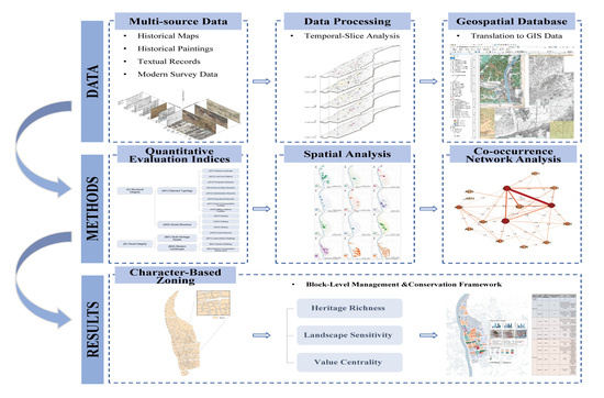
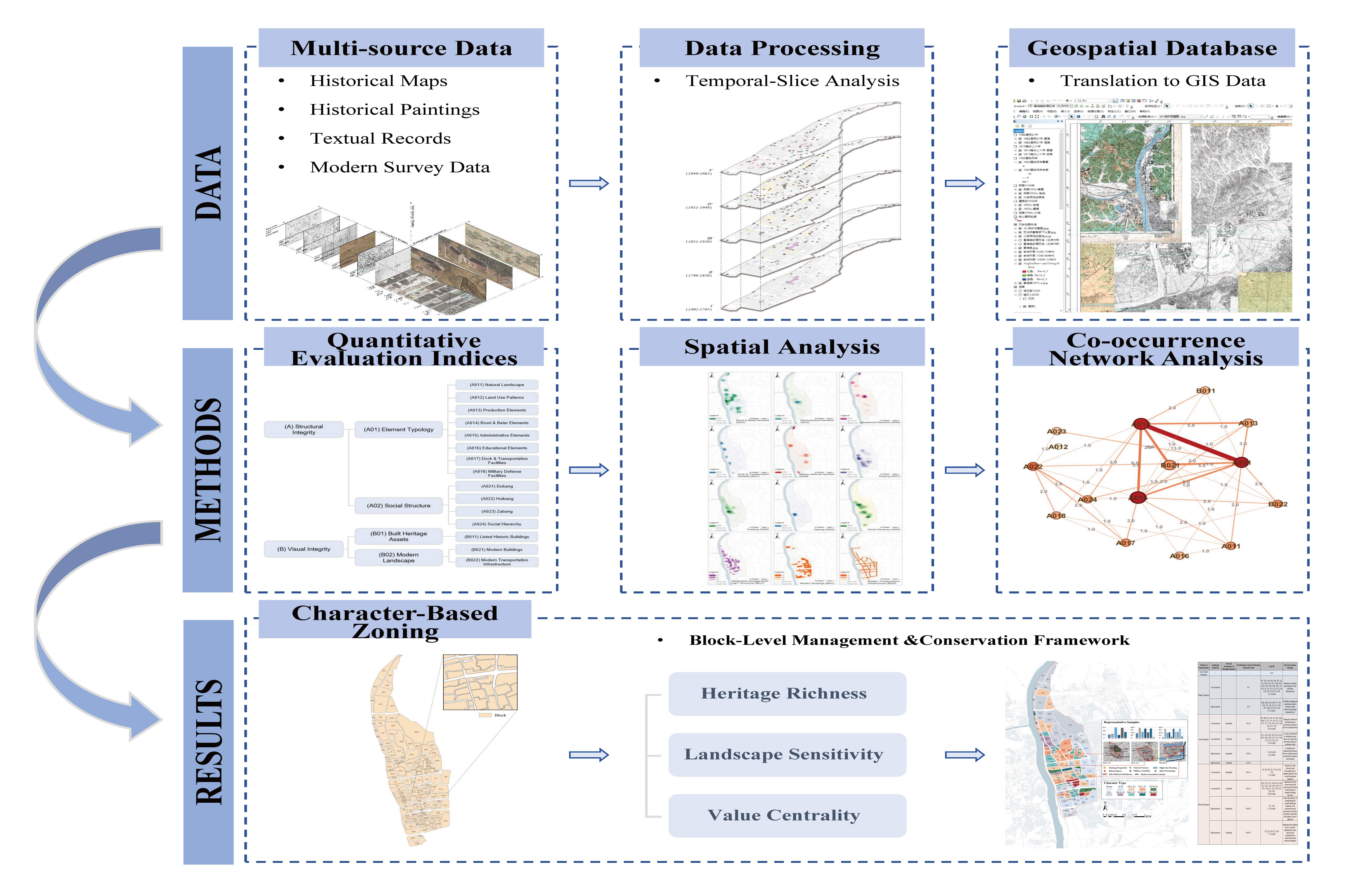
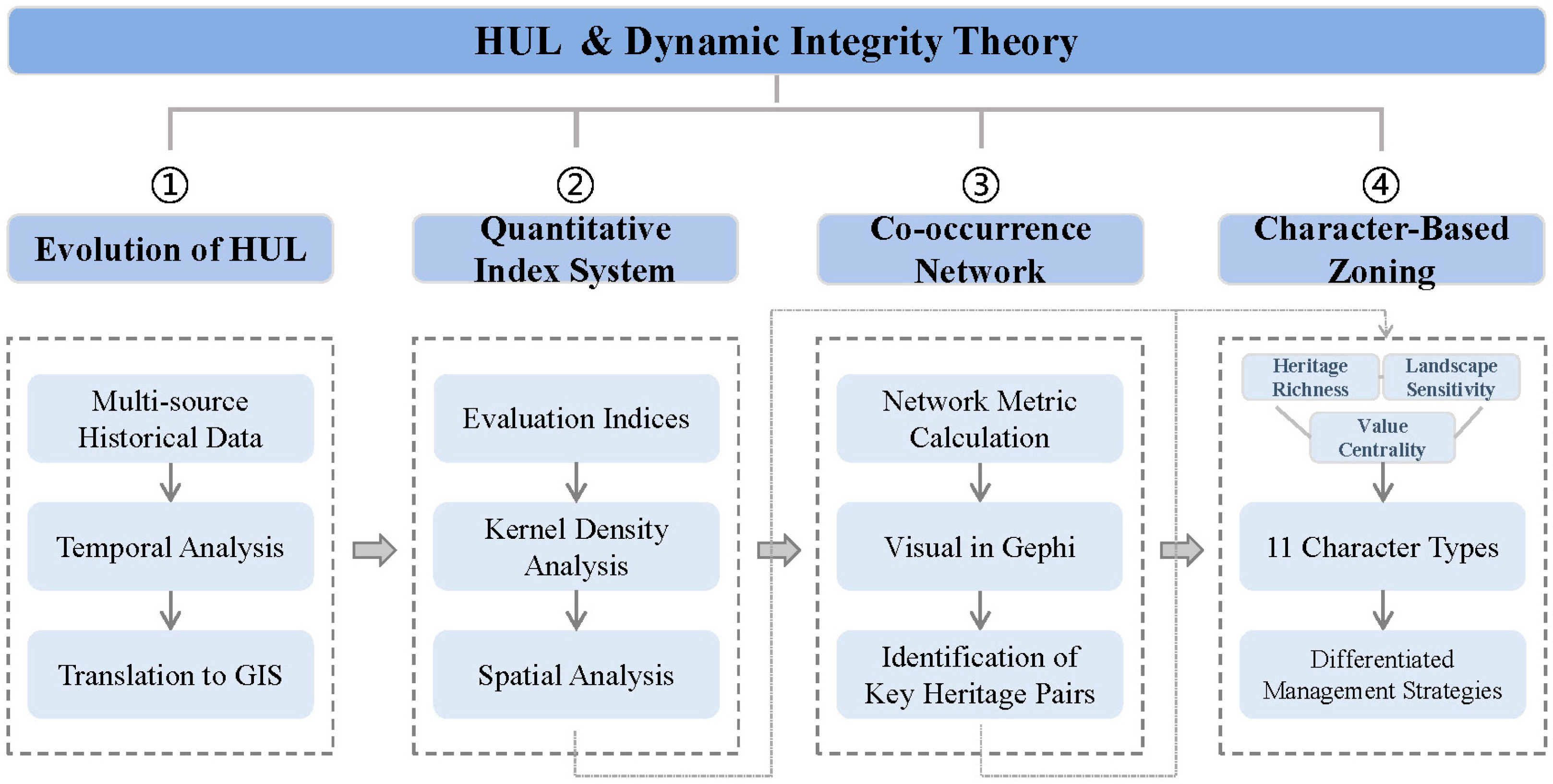
Building upon these theoretical foundations, this study introduces the concept of HUL and Dynamic Integrity to construct a quantitative assessment framework towards character zoning (Figure 1). Unlike previous studies that predominantly focus on the retrospective description of historical evolution, this research aims to address the critical challenge of prospective management and control. The specific research objectives are as follows:
Figure 1. Research framework.
  • To unravel the historical stratification and evolution of HUL: This objective involves a systematic examination of the spatio-temporal evolutionary trajectory of the Jingdezhen historic urban area, it aims to identify the specific stratification characteristics and evolutionary patterns distinct to various historical periods, thereby establishing a robust historical data foundation for the subsequent quantitative analysis.
  • To establish a quantitative index system: This objective involves integrating the theory of Dynamic Integrity into the HUL assessment framework to develop a multi-dimensional indicator system. It aims to facilitate a scientifically rigorous visual representation and quantitative interpretation of the complex HUL system.
  • To reveal the internal structural logic of the heritage system: By employing Co-occurrence Network Analysis, this study provides a methodological pathway to conduct an in-depth analysis of the mechanisms of association between diverse heritage elements. The goal is to synthesize their inherent structural characteristics and the underlying organizational patterns of the urban system.
  • To implement Character-Based Zoning and derive management strategies. Adopting the urban block as the fundamental spatial unit, this study conducts HUL character zoning based on the quantitative assessment results of Heritage Richness, Landscape Sensitivity, and Value Centrality. Consequently, it derives targeted planning strategies and conservation schemes specific to each identified character zone.

2. Materials and Methods

2.1. Study Area

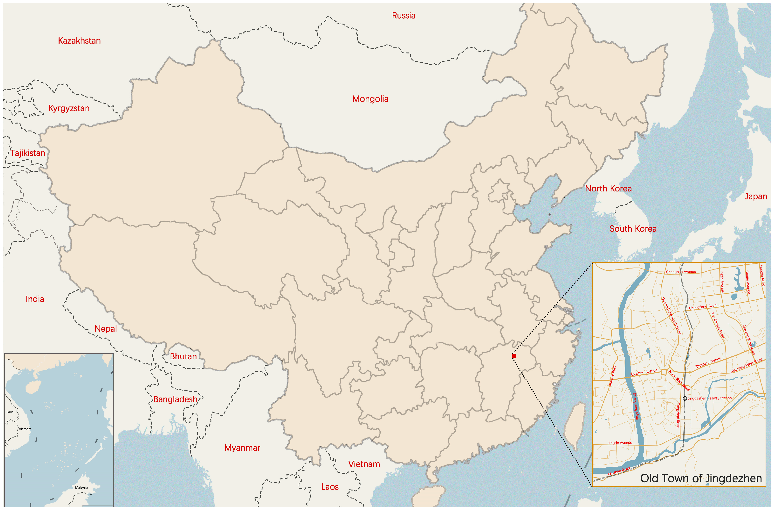
This study defines a clear spatio-temporal framework to capture the complete evolutionary trajectory of Jingdezhen’s porcelain industry-driven urban morphology. Temporally, the study spans from 1402 to 1960, a period marked by the establishment of the Ming imperial kilns and the institutionalization of the imperial porcelain production system in Jingdezhen, culminating in the basic formation of the ceramic industrial system of the People’s Republic of China. Spatially, the study area covers approximately 326.81 hectares (Figure 2), bounded by the Chang River to the west, Wulong Mountain to the east, Guanyin Pavilion to the north, and Xiaogangzui to the south. This area encompasses the core zones of porcelain production, trade, and daily life, which together constitute an integrated historic urban landscape.
Figure 2. The location of the study area.
As a long-established urban core, this area exhibits a high degree of functional heterogeneity and spatial interweaving, shaped by centuries of artisanal production. The area records a stratified historical sequence extending from the Five Dynasties period to the present, with three principal subareas, namely Guanyin Pavilion, Zhushan, and Luomaqiao, preserving layered deposits of kiln remains. This spatial structure is neither uniform nor linear but highly complex: commercial prosperity fostered specialized divisions of labor, while sustained migration since the early Qing dynasty gave rise to diverse guild organizations [27]. Moreover, within the dense urban fabric, the coexistence of local Daoist beliefs, kiln god worship, and introduced religions (Christianity and Islam) generated a rich socio-cultural network, contributing to the exceptional complexity and richness of the landscape.
Notably, the industrial transformation of the mid-twentieth century represents another critical layer of dynamic integrity. In the early 1950s, porcelain production underwent gradual industrialization, with new factories constructed directly over historic kilns and workshops. Representative examples include the Jianguo Porcelain Factory, located adjacent to the Imperial Kiln site, and the Hongguang Porcelain Factory, established within the Luomaqiao kiln area. Although distinct from pre-industrial attributes, these facilities demonstrate the continued evolution of urban functions. They testify to the enduring influence of traditional production practices on modern industrial development and form an organic component of Jingdezhen’s broader ceramic landscape.

2.2. Data Collection

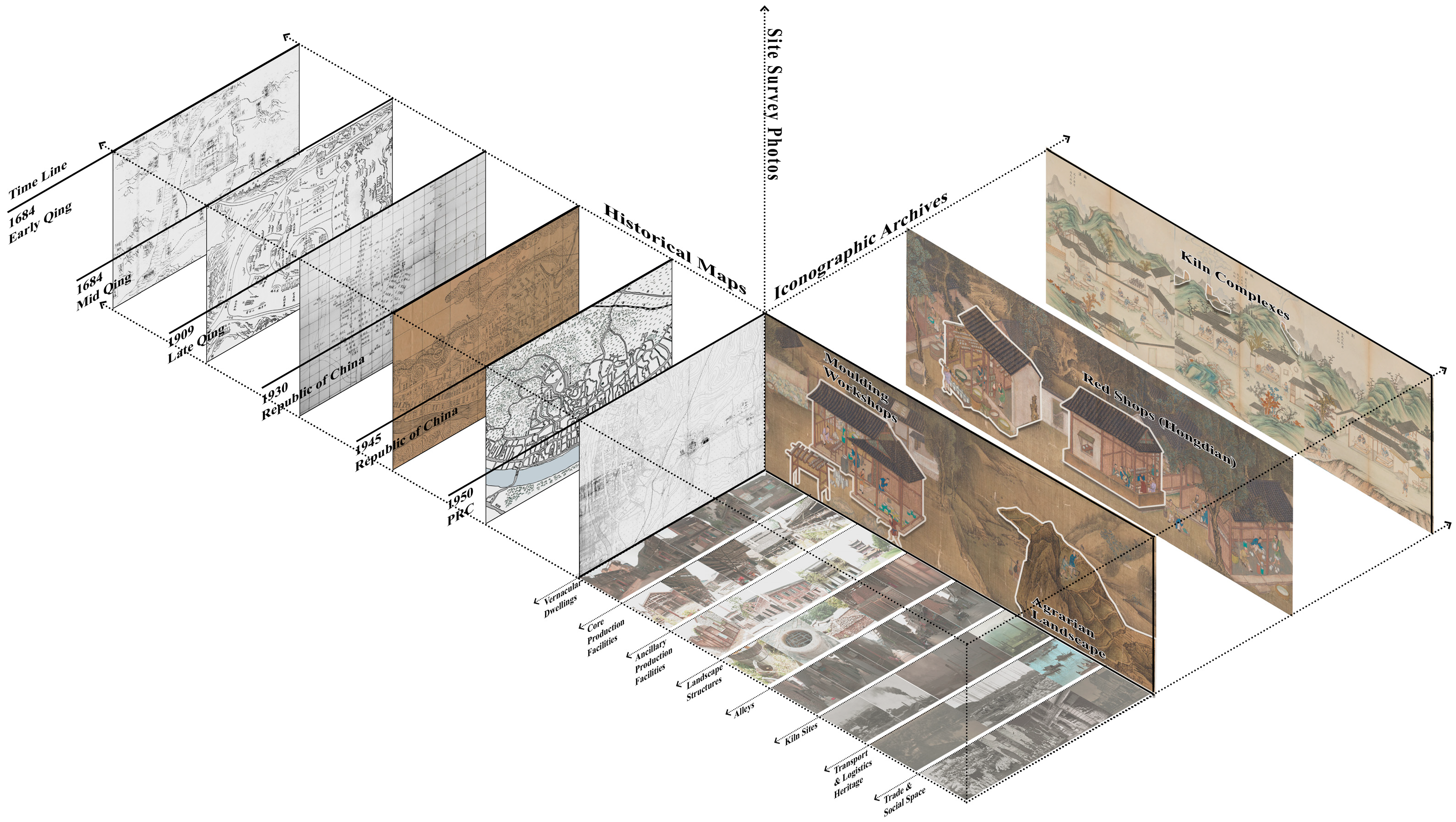
Compared to traditional methods, we need to identify and document all historical landscapes as comprehensively as possible. Historical archives make visible contributions to the reinterpretation of landscapes, since ancient maps, paintings, literature and images depict them in textual and metaphorical forms [5,28,29,30]. These sources offer new ways of narrating the history of landscapes, presenting visual stories and perspectives, both official and unofficial [31,32,33,34]. In this study, a historical map translation approach was applied, integrating administrative maps, paintings, gazetteer records, and other historical documents with archaeological data and field surveys (Table 1) and (Figure 3). This enabled the construction of temporal slices to analyze the historic landscape of Jingdezhen. Each source was critically examined for discrepancies and complementarities. Maps of the same period, for instance, often differ according to purpose. Incomplete or biased records were cross-checked with multiple references, focusing on the earliest sources as a methodological principle for reliability. In addition, attention was paid to the political, cultural, and ideological dimensions embedded in historical maps.
Table 1. Detailed inventory of historical data sources, integrating textual records and visual archives.
Figure 3. Overview of muti-source visual data: from historical archives to current site surveys.

2.3. Methodology

2.3.1. Historical Data Translation and Spatio-Temporal Mapping

(1)
Definition of Temporal Slices
To systematically describe the evolution of Jingdezhen’s HUL, it is first necessary to apply temporal slicing to multi-modal historical data sources. The delineation of historical phases is strictly based on the structural evolution of heritage elements and key turning points in urban morphology. Accordingly, the city’s development is categorized into five distinct morphological stages, namely:
Period I: Consolidation
Spanning from Ming Hongwu to the Qing Qianlong reign (1402–1795), this era of consolidation was defined by strong imperial authority that centralized porcelain production within the Imperial Kiln system. The historic urban area consequently maintained a relatively stable configuration, largely shaped by natural topography and ceramic manufacturing activities.
Period II: Expansion
During the expansion phase from 1796 to 1850 (Qing Jiaqing to Daoguang), the decline in official kilns coincided with the growth of private workshops, maritime trade and missionary activity. Intensified migration fostered socio-spatial organizations and religious diversity, broadening the composition of the urban landscape.
Period III: Decline and Transition
The period from 1851 to 1921 (late Qing, Xianfeng to Xuantong) was marked by decline and transition. Rebellions and political instability disrupted porcelain production, suspending imperial kilns, and severely reducing private ones. Military installations and related features became more prominent within the urban fabric.
Period IV: Hybridization
From 1921 to 1949 (the Republican era), a hybrid landscape emerged. Despite the fact that the porcelain industry is weakened by warlord conflicts, wartime destruction, and economic decline, the introduction of western technologies and new infrastructure, along with the influx of diverse social groups, led to the coexistence of traditional and modern, Chinese and Western elements.
Period V: Modernization
During the early years of the PRC (1949–1962), a drive for modernization saw historic kilns reorganized into state-run porcelain factories, embedding industrial modernity in the old town. The road networks and urban facilities were restructured, reshaping the spatial framework of the historic core of Jingdezhen.
(2)
Translation Process from Historical Information to GIS Data
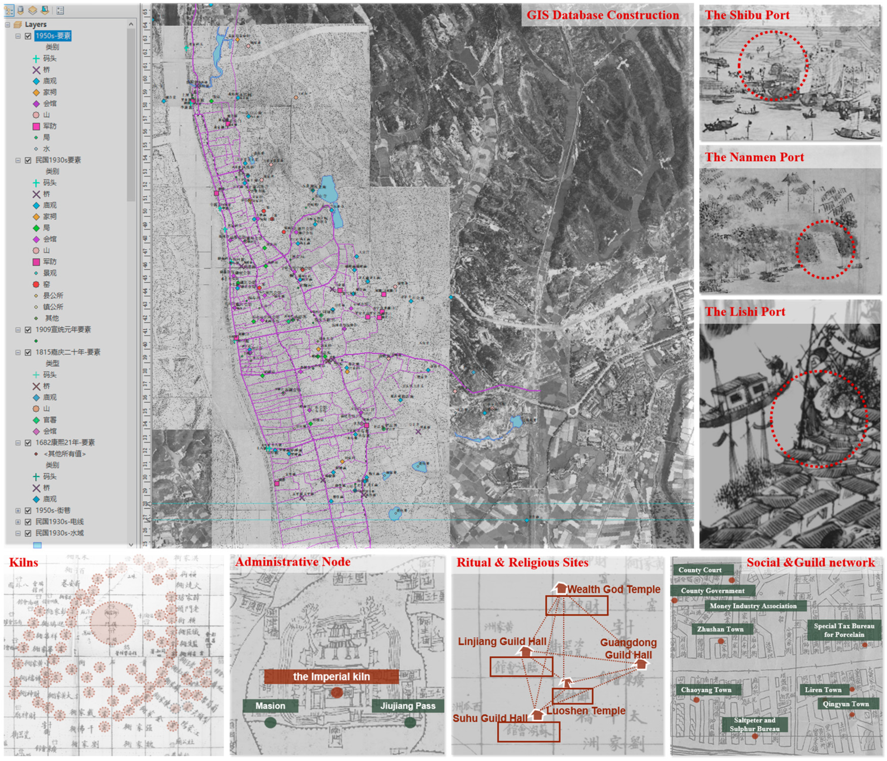
Based on the defined temporal slices, a GIS-Based Mapping method was applied to convert qualitative historical information into quantitative spatial data (Figure 4).
Figure 4. The process of historical data translation and spatial reconstruction based on multi-source archives. The top-right inset details the structure of the GIS spatial layer dataset construction.
  • Source Compilation: Historical maps and textual descriptions were selected as primary sources for each period. Additionally, high-resolution aerial imagery from 2023 served as the base map for georeferencing. The CGCS2000 coordinate system was applied as the spatial reference.
  • Spatial Georeferencing: Eight landmarks and road intersections were selected as ground control points (GCPs). Using the georeferencing tool in GIS, these points were matched between the early-modern maps and the 2023 aerial imagery. This process continued until the layers were accurately aligned (Table 2). Based on the continuity of historic urban fabric, core street networks, natural water systems, and key heritage elements remain spatially stable. Consequently, these georeferenced early-modern surveys serve as reliable spatial references. They enable the precise tracking and localization of ancient heritage sites, overcoming the inherent limitations of traditional maps in georeferencing. Vectorization and Reconstruction: Heritage elements identified from ancient historical records and maps were systematically converted into vector data. To ensure spatial accuracy, these ancient heritage points underwent a rigorous multi-source calibration process to align with modern geographic coordinates. Specifically, spatial information from historic maps was cross-validated with textual records (e.g., local gazetteers) and oral histories. This integration enabled the precise geolocalization of heritage elements.
  • Database Construction: Finally, a diachronic geospatial database was established, stacking these five temporal layers to support the subsequent evaluation of heritage richness and dynamic integrity.
Table 2. Eight precise reference coordinates.

2.3.2. Construction of Quantitative Evaluation Indices

This study systematically compiles the entire historical landscape of Jingdezhen into a dynamic framework to analyze the continuity and integrity of its urban landscape (Table 3). In this framework, structural integrity refers to both the typologies of heritage elements and the social structures that embody the genius loci. In Jingdezhen, these structures evolved from lineage, territorial, and occupational networks into the Bang guild system and the local gentry system, which together organized production and sustained resilience. Visual integrity, in turn, refers to the spatial distribution and continuity of built heritage assets, while also accounting for transformations introduced by the modern landscape, such as modern buildings and transportation infrastructure.
Table 3. Quantitative Evaluation Index System.
Data for element typologies and social structures were drawn from historical archives, while information on tangible remains and modern interventions was derived from the Third Cultural Relics Census, municipal records, and open-source geo-spatial datasets.
In calculating the eight sub-indicators under element typologies (A01), This research adopts the Historic Land Use Assessment (HLA) methodology [35,36,37]. Its core theory posits that Heritage Period Value (HPV) diminishes gradually across successive dynasties. Historic Layer Depth (HLD) serves as the primary metric for measuring the depth of historical accumulation. HPV is the fundamental numerical variable used to calculate HLD. The formula is as follows:
H L D = i = 1 Z H P V ( i )
HLD = Historical Layering Depth, HPV = Historical Period Value, Z = Total Historical Layers, i = Historical Period. (Period I = 5, Period II = 4, Period III = 3, Period IV = 2, Period V = 1).
To integrate these measures into a comprehensive evaluation framework, the Fuzzy Analytic Hierarchy Process (FAHP) was subsequently used to assign weights to the indicator layers. Developed from the traditional Analytic Hierarchy Process (AHP) and incorporating fuzzy set theory [38,39], FAHP provides a robust multi-criteria decision-making approach well suited for evaluating complex heritage systems. In this study, weights were derived by constructing reciprocal judgment matrices, calculating normalized weights, and performing consistency checks through eigenvalue matrices, is provided in Appendix A (Table A1 and Table A2).
To ensure the robustness and transparency of the evaluation model, an expert panel of five specialists was established. This panel was tasked with prioritizing the selected indicators. The expert panel comprised five diverse specialists. It included two professors of urban planning and morphology, and a senior researcher in GIS and spatial analysis. The group also featured a senior architect in historic building conservation and a senior practitioner from the local heritage management department. All selected experts hold doctoral degrees or senior professional titles. They possess over ten years of research or practical experience in fields directly related to urban heritage. This procedure established the relative importance of each sub-indicator within the overall framework. Based on their pairwise comparisons, the weights of the sub-indicators were calculated using the Fuzzy Analytic Hierarchy Process (FAHP) in the SPSSAU platform (Version 24.0). The consistency ratio (CR) of the judgment matrix was 0.0415, which is below the acceptable threshold, indicating that the consistency test was satisfied. This procedure established the relative importance of each sub-indicator within the overall framework.
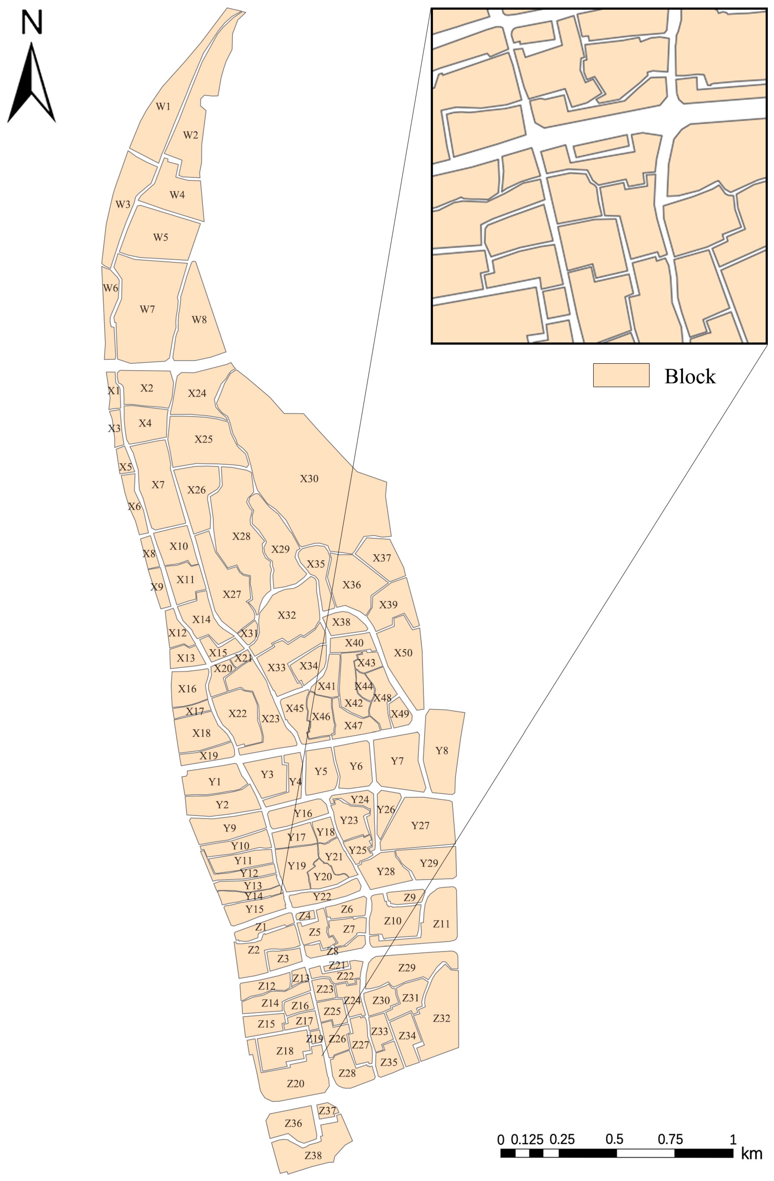
In this study, block units were adopted as the operational scale for analysis. Based on existing Jingdezhen road data, a road network system was first constructed, and the road spaces within the study area were subsequently removed. Drawing on the block divisions recorded on the 1950 historical map, the smaller parcels were then eliminated, producing an independent parcel layer data set (Figure 5).
Figure 5. Block-scale units mapped from OSM and historical maps.
To analyze the spatial distribution of heritage indicators, we applied Kernel Density Estimation (KDE). KDE is grounded in the first law of geography, which posits that locations closer to a core element exert stronger influence. This method highlights spatial heterogeneity and the distance decay effect of the central intensity, thus enabling fine-grained visualization of diffusion patterns. It has been widely used in studies of urban facility services, transportation risks, and commercial clustering. The general formula is the following [40,41,42,43].
f ( x ) = i = 1 n 1 h 2 K ( x x i h )
K ( x x i h ) = 3 4 ( 1 ( x x i ) 2 h 2 )
In this formula, K denotes the kernel function, and h represents the search radius (bandwidth), that is, the spatial extent of the surface around the point x, which determines the smoothness of the kernel density surface; n indicates the number of feature points within the search bandwidth around x.
All relevant data were imported into the ArcGIS platform (version 10.8.2), where kernel density analysis converted vector point data into raster surfaces to visualize spatial clustering.
Bandwidth selection in Kernel Density Estimation (KDE) depends on geographical characteristics and the research scale [44,45]. This study employs KDE at the block scale. Based on the average area of blocks within the study site, the mean influence radius for heritage elements is determined to be approximately 200 m. This value serves as the reference for the optimal bandwidth.
Finally, the relative contribution ratio of each indicator within the block unit is calculated based on its assigned weight. This ratio serves as the quantitative basis for character-based zoning. The formula is as follows:
F i = W i × d i j = 1 15 ( W j × d j ) × 100 %
In this formula, F i , W i , d i represent the contribution ratio, weight, and sum of kernel density for the ith indicator, respectively.
This metric provides the quantitative basis for delineating heritage character areas according to the following classification criteria. The threshold values are adapted from the parameter settings commonly used in urban functional zone identification based on POI density analysis [46]:
  • Single-Character Zone: A unit is defined as a single-character zone if the relative contribution of a specific category F i is ≥50%, indicating a dominant heritage attribute.
  • Dual-Character Zone: A unit is designated as a dual-character zone if no single category reaches 50%, but exactly two categories exhibit contribution ratios ranging between 20% and 50%.
  • Mixed-Character Zone: A unit is classified as a mixed-character zone if no single category exceeds 50%, and three or more categories exhibit contribution ratios ≥ 20%.
  • Null Zone: A unit is categorized as a null zone if the kernel density for all heritage categories is zero ( F i = 0).

2.3.3. Co-Occurrence Network Analysis Model

This study employs co-occurrence network analysis to elucidate the underlying functional associations and intrinsic structural logic among heritage elements in Jingdezhen [47]. The specific methodological steps are outlined as follows:
First, the 15 evaluation indicators characterizing plot features were defined as the network nodes. Second, edges were established based on the principle of spatial proximity. When two or more dominant elements meeting this threshold co-occurred within the same spatial unit (i.e., the block-scale unit), a co-occurrence relationship was identified, thereby forming a connecting edge.
To quantitatively analyze the structure of the heritage system, this study selected the following key network metrics: (1) Degree Centrality. Used to measure the centrality of specific heritage types within the network. A higher degree indicates stronger connectivity with other elements and a dominant position within the heritage system. (2) Weighted Degree. Incorporates edge weights to further assess the intensity of associations between elements. Finally, the Gephi software (version 0.10.1) platform was employed to visualize the network structure.

2.3.4. Character-Based Zoning and Classification Method

To enable refined classification and differentiated strategies, this study proposes a three-tier hierarchical screening framework corresponding to heritage richness, landscape sensitivity, and value centrality. Heritage Richness measures the diversity of heritage resource types, reflecting the material basis of historical stratification. Value Centrality evaluates the structural importance of heritage elements within the urban system. Landscape Sensitivity assesses the visual vulnerability and carrying capacity of the historic fabric when exposed to modern interventions, particularly in relation to building height, volume, and spatial compatibility. The framework proceeds as follows (Table 4):
Table 4. Character Unit Classification Framework.
Tier 1: Classification by Heritage Richness. Units are categorized by the count of significant characters: single-character (one), dual-character (two), and mixed-character (three or more).
Tier 2: Classification by Landscape Sensitivity. Units are classified as high or low sensitivity based on modern landscape indicators (B02), highlighting areas requiring careful integration of historic and modern elements.
Tier 3: Classification by Value Centrality. Co-occurrence analysis is applied to dual and mixed units to identify key heritage pairs.
This mechanism systematically distinguishes character units, providing an evidence-based foundation for prioritized conservation interventions.

3. Results

3.1. Historical Stratification and Evolution of HUL

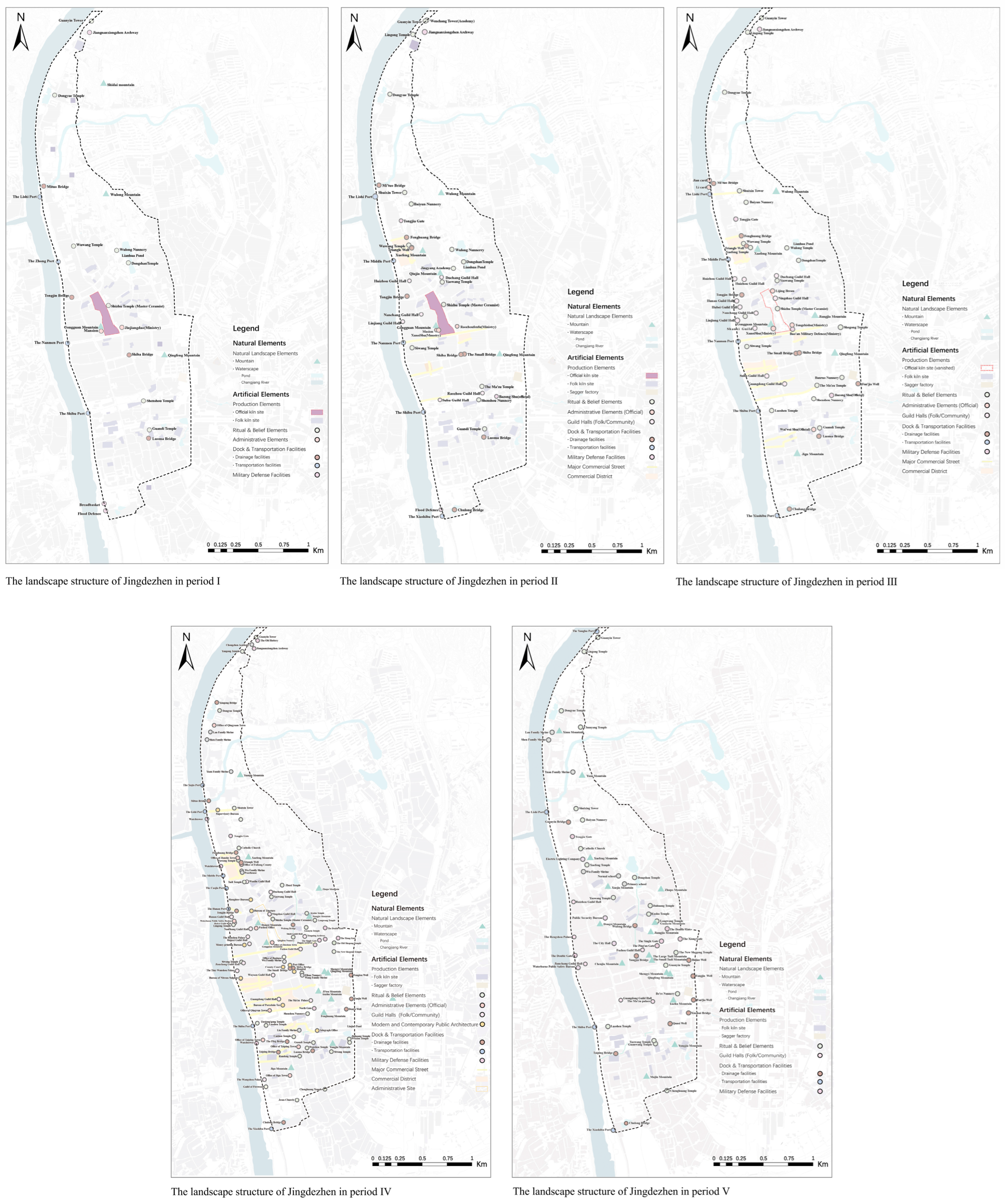
In Jingdezhen, heritage values have crystallized through the temporal stratification of diverse elements across successive periods, reflecting an evolutionary continuity that sustains their cultural significance [48,49,50]. The spatial configuration serves as a physical manifestation of these values (Figure 6). By integrating these historical layers (Periods I–V), this study constructs a multi-dimensional layering model, providing a comprehensive framework to decode Jingdezhen’s historic urban landscape and offering methodological guidance for the conservation of its living historic quarters.
Figure 6. Types and spatial distribution of heritage elements in Jingdezhen’s historic urban area across different periods.
Spatial analysis reveals that the extent of heritage elements remained remarkably stable, circumscribed within the boundaries of the ‘Taoyang Thirteen Li’. However, the spatial foci shifted significantly over time. Heritage density along the riverfront peaked during Periods III–IV, reflecting the logistic prosperity and river-dependent trade of the era, before declining in Period V. This shift coincided with increased activity in the eastern hillsides, likely driven by modern road and railway development that diminished the functional centrality of the Changjiang River as the primary logistics channel.
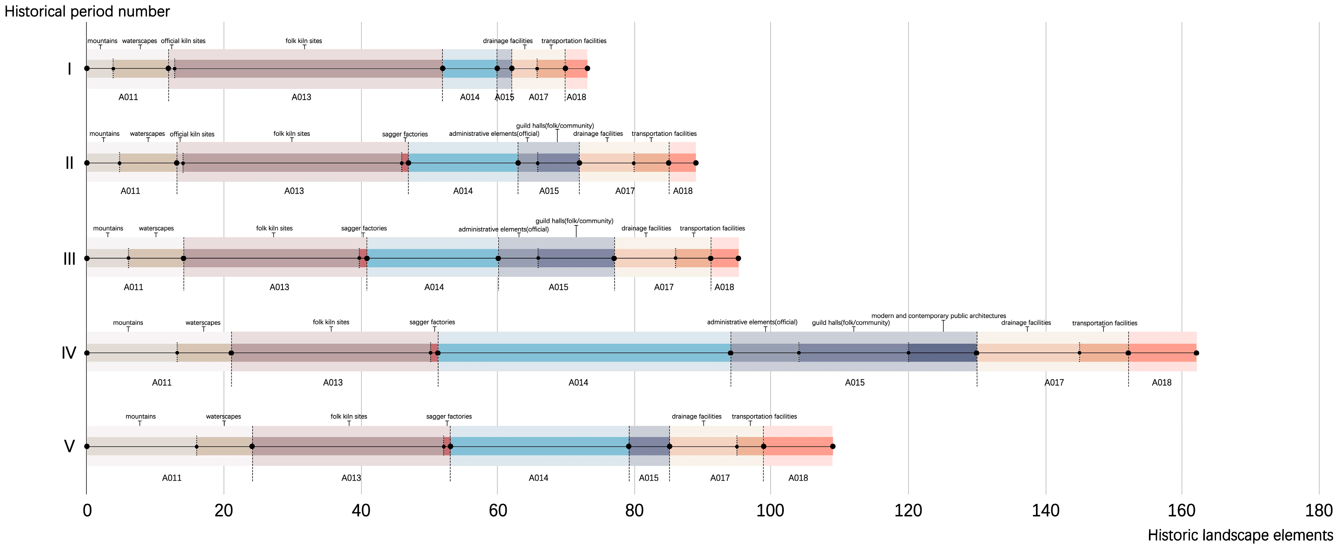
Visualization results (Figure 7) indicate that the abundance and diversity of heritage elements followed a unimodal trend, peaking in Period IV before declining. This highlights the historical variability of heritage elements alongside their enduring spatial stability. Period IV represented the zenith of structural complexity, exhibiting a landscape hierarchy markedly more intricate than other periods.
Figure 7. Statistical analysis of different period layers.
Furthermore, the HUL of Jingdezhen exhibits a palimpsest character, where successive historical layers overlap and intersect. Within this process, certain features experienced renaming or functional transformation, reflecting the temporal disconnect between the persistence of material fabric and the evolving cultural meanings. In parallel, the study identified event-based cultural landscapes, such as elements that appeared in Period III but disappeared by Period IV or V. These patterns illustrate the temporal and spatial mobility of heritage, whereby material landscapes may migrate or vanish, yet cultural continuity is maintained through narrative fluidity and collective memory. Together, these dynamics demonstrate how social change and historical events actively shaped the continuity, transformation, and resilience of the historical area of Jingdezhen.

3.2. Quantitative Index System Integrating Dynamic Integrity

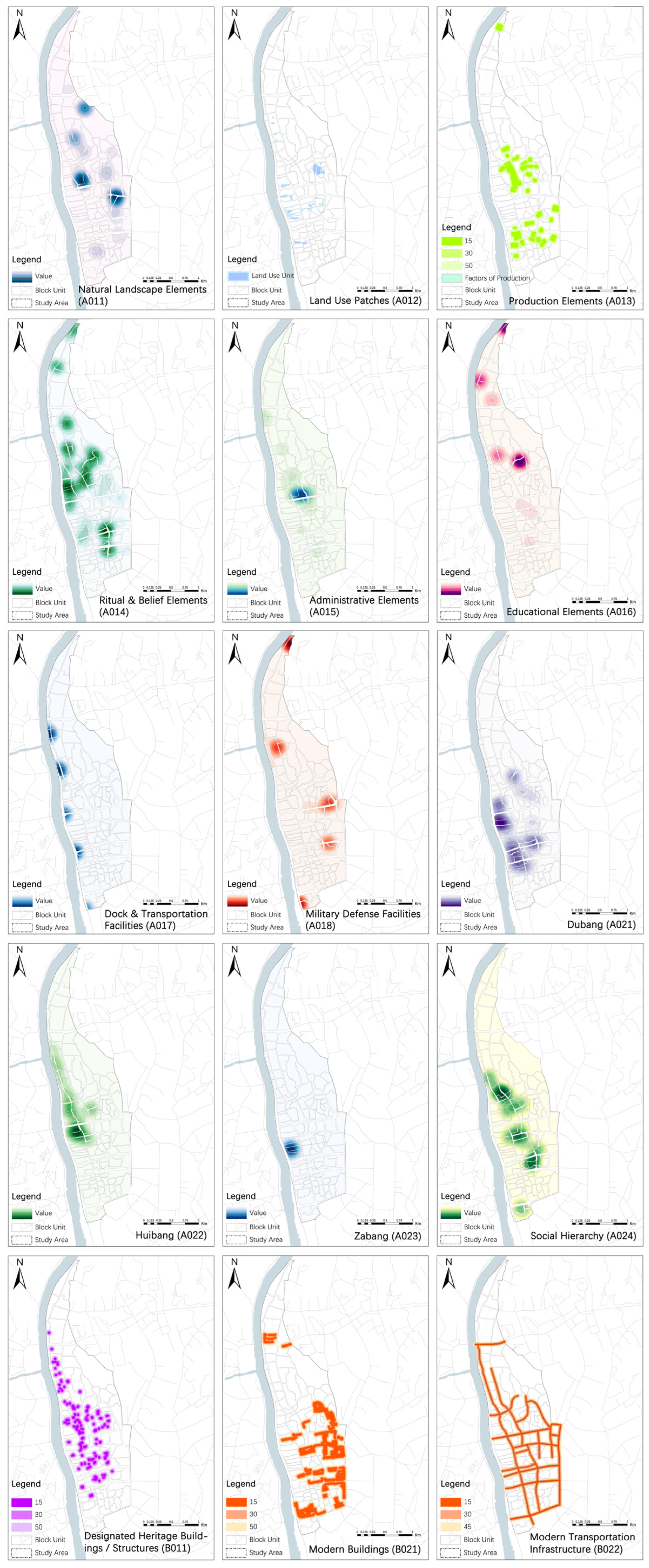
Drawing on the Dynamic Integrity framework, this study employed KDE in ArcGIS to visualize the spatial clustering and morphological characteristics of 15 heritage indicators (Figure 8). The resulting density surfaces characterize the spatial distribution and clustering patterns across the historic urban area, revealing a pronounced spatial heterogeneity. Among all indicators, ritual and belief and production elements constitute the predominant spatial footprint, covering the most extensive area. This pattern suggests that Jingdezhen historically functioned as an integrated industrial–ritual landscape, where production activities and belief-related spaces were spatially intertwined rather than segregated.
Figure 8. GIS-based spatial distribution of the 15 evaluation indicators. At the spatial level, this analysis visually demonstrates the distribution of diverse elements within Jingdezhen’s heritage system. It also highlights the visual threats posed by modern landscapes to these historic structures.
Urban defense elements exhibit a clear polycentric clustering pattern. These structural nodes aggregate primarily at strategic northern and southern gateways alongside key transport intersections. Together, they form a robust peripheral defensive ring. This spatial configuration defines the historical urban boundary and solidifies the settlement’s nodal framework.
Social elements manifest strict spatial stratification based on guild affiliations. The Huibang guild shows a high density spatial coupling with the upstream and midstream riverfront interface. This layout directly correlates with the historical inflow routes for raw materials. The Zabang guild clusters strictly in the downstream sectors. This spatial positioning corresponds to the outbound logistics network. The Dubang guild exhibits a hybrid spatial topology. It overlaps with both Huibang and Zabang in riverine zones. Furthermore, it penetrates the higher elevation hinterlands in the eastern and southern peripheries. This functional zoning illustrates a highly specialized spatial division of porcelain labor.
In the contemporary landscape, modern building clusters show a clear expansion tendency toward the southeastern edge. Meanwhile, modern road networks show a high degree of overlap with historical streets, indicating a strong path dependency in the evolution of the urban spatial structure.

3.3. Internal Structural Logic of the Heritage System

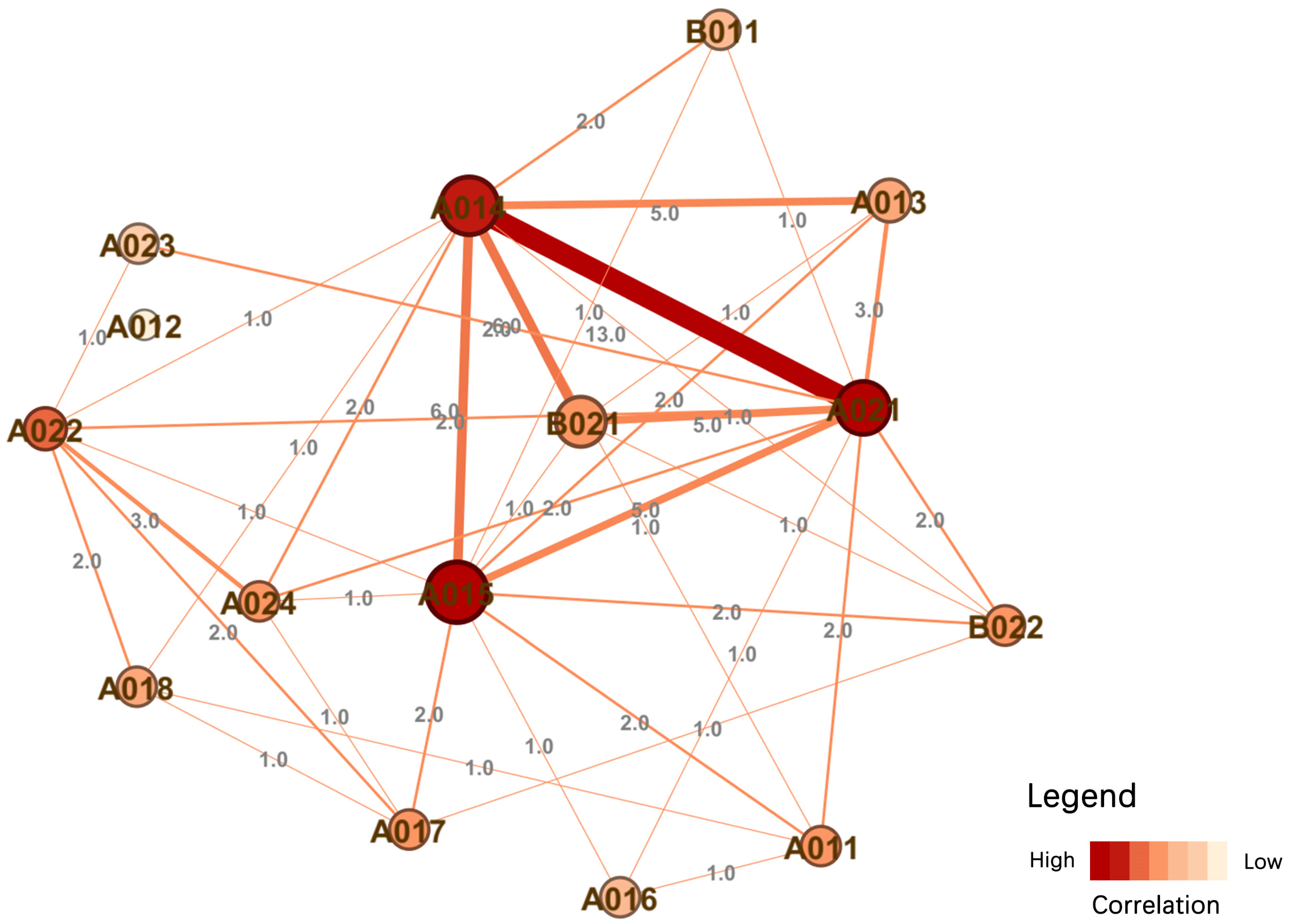
Gephi was used to visualize the co-occurrence network of heritage character elements (Figure 9), aiming to uncover the underlying logic and structure of the heritage system and its vulnerability to modern visual threats in Jingdezhen.
Figure 9. The co-occurrence network of heritage character elements. Node numbers correspond to the indicator codes (e.g., A014: Ritual & Religious Elements, A015: Administrative Elements, and A021: Dubang). The size and color intensity of the nodes reflect their structural centrality within the network. The thickness and numerical values of the edges indicate the correlation strength between element pairs. This co-occurrence network visually reveals the structure and hierarchy of Jingdezhen’s heritage network, as well as its structural vulnerability under the impact of modern visual threats (e.g., B021).
The network topology is anchored by four dominant hubs that exert a profound influence on the overall system: Ritual and Belief (A014), Administration (A015), Production (A013), and the Dubang Guild (A021). These nodes exhibit significantly higher degree centrality and connectivity than other elements, crystallizing a core heritage structure that seamlessly integrates industrial production with the spiritual and administrative dimensions of daily life. This concentration of connectivity suggests that these four elements are the primary drivers maintaining the system’s structural stability.
The analysis further identifies a profound overlap between historical and modern landscapes, manifesting as high-frequency co-occurrence pairs. Results indicate that nodes representing modern visual threats, such as modern buildings (B021), exhibit strong connectivity with core heritage elements (A014, A021). Similar strong links are observed with the peripheral Huizhou Guild (A022). This indicates that modern visual elements are deeply integrated within the core nodes of the heritage network. This spatial pattern is not limited to the periphery. Specifically, notable conflict pairs involve Ritual and Belief versus Modern Buildings (A014–B021). Similar tensions exist between Dubang Guilds and both modern buildings and transportation infrastructure (A021–B021; A021–B022). These element pairs represent the critical interfaces of landscape evolution; as such, they constitute the primary focus for the Management of Change and should be prioritized in future adaptive conservation and planning strategies. These conflict pairs function as key interfaces between heritage preservation and contemporary development [51]. These sites constitute the primary focus of “Managing Change” within the HUL framework. They must be prioritized in future adaptive conservation and zoning strategies.

3.4. Character-Based Zoning and Management Strategies

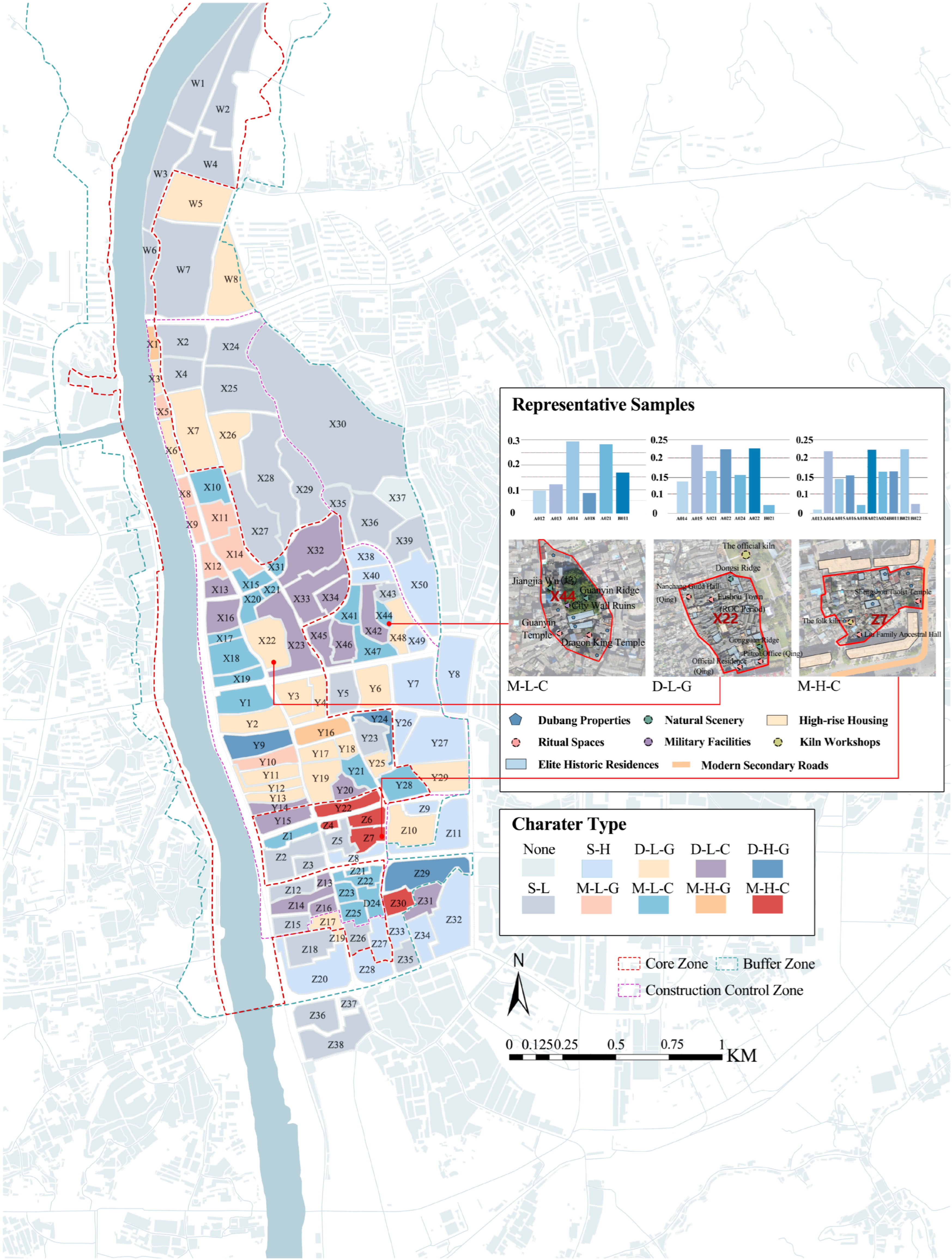
We applied the established three tier hierarchical screening framework. This framework evaluates heritage richness, landscape sensitivity, and value centrality. Based on this logic, we classified all 125 spatial units into 10 distinct character types. The specific screening criteria included the quantity of dominant elements, the presence of modern elements (B021, B022), and the co-occurrence of core heritage elements (A013, A014, A015, and A021). Subsequently, we mapped the spatial distribution of these resulting character units (Figure 10). The results reveal a clear morphological structure characterized by “large-scale agglomeration, scattered core nodes, and gradient diffusion”.
Figure 10. Spatial Visualization of Character Zoning and Representative Character Units.
First, heritage richness exhibits a pronounced pattern of centripetal enrichment. The zoning results reveal that the area spanning from Block X3 to Z17 aggregates the vast majority of Dual- and Mixed-Character units. These units constitute the heritage core zone characterized by the highest value density within the historic urban area. In contrast, Single-Character units are predominantly clustered in the peripheral zones, forming a gradient structure that diminishes from the core toward the margins.
Second, landscape sensitivity exhibits a strong southeastern agglomeration trend. High-sensitivity units are non-uniformly distributed, showing a significant concentration within the southeastern sector of the urban area. This spatial pattern highly coincides with the vector of modern urban expansion, identifying the southeastern peripheral zone as the most acute interface of conflict between historic character and modern landscape.
Notably, the M-H-C units were identified as the most critical category for management intervention. These units are primarily concentrated in the southern portion of the heritage core. Characterized by the juxtaposition of high historical stratification value and high risk of modern interference, they constitute a high-risk, high-value zone within the heritage system. Consequently, they represent priority targets for the implementation of stricter morphological controls and adaptive conservation strategies.
Furthermore, this study compared its zoning results with the historical urban construction control zone defined in the Jingdezhen City Master Plan (2009–2030), alongside the heritage core and buffer zone boundaries designated in official documents. The findings reveal two key points. First, the spatial extent of our identified core dual- and mixed-character units is largely consistent with the core zone. However, our analysis also uncovers several units (Units X41–47 and Z29–31) that demonstrate equal importance but remain excluded from the official core zone. Second, it is worth noting that traditional buffer zones are typically delineated as large, homogeneous areas. This conventional approach often obscures internal spatial variations. In contrast, our model precisely identifies several high-value yet highly threatened areas (Units Y22, Z4, Z6, Z7, and Z30) situated between the buffer zone and the heritage core. This finding highlights the necessity of our proposed framework for identifying potentially highly sensitive zones overlooked by official planning. Ultimately, it provides clear directions for future fine-grained zoning management.

4. Discussion

4.1. Jingdezhen’s Dynamic Integrity: Patterns and Implications

Based on the preceding analysis of heritage character zoning and the co-occurrence network, this study elucidates the structural logic and evolutionary implications of dynamic integrity within the historic urban area of Jingdezhen.
The analysis reveals that the heritage system is characterized by complex combinatorial patterns dominated by specific core elements. Belief and ritual practices (A014) operate as a pivotal nexus of social and spatial life, attaining the highest connectivity in the parcel network and highlighting their essential role in maintaining cultural continuity and regulating social order. The pronounced interconnections between administrative elements (A015) and belief (A014), production (A013), transportation (A017) and Huizhou guild networks (A022) demonstrate that administrative governance not only exerted a leading influence on ceramic production and trade logistics, but also operated as a core governance node ensuring the cohesion and functionality of the broader heritage system.
The Dubang (A021), functioning as a localized guild organization, served not merely as a principal support for kiln production but also as a cornerstone of the resilient production system and social network through its synergistic ties with other guilds (A022, A023). However, the analysis highlights a critical vulnerability: amidst rapid modernization, heritage attributes associated with the Dubang have faced the most severe impact. This trajectory reveals the fragility of traditional ceramic production elements, encompassing community bonds, craftsmanship, spatial patterns, and architectural traditions, when subjected to the pressures of urban transformation.
Spatially, the heritage network manifests a distinct morphological pattern characterized by “core agglomeration, multi-nodal dispersion, and gradient diffusion”. This configuration not only reflects the high concentration of ceramic production and social activities in the central zones but also illustrates the systemic diversity and richness driven by peripheral elements. Broadly, this underscores the hierarchical spatial organization and relational networks that have crystallized within the Jingdezhen heritage system throughout its historical evolution.
A notable revelation from the quantitative analysis is that the Imperial Kiln Factory, traditionally viewed as the apex of the official kiln system, does not emerge as the solitary core heritage unit in the results. This phenomenon can be attributed to two primary factors. First, the singular official production system experienced a rapid decline following the end of the Qing dynasty, leading to a disruption in temporal continuity [52]. Second, and more critically, the “official-supervised, folk-operated” mechanism (guan du min ban) meant that the official kiln network was never confined to the factory walls. Instead, it formed an organic whole integrated with surrounding folk kilns, transport docks, and industry-related temples [53].
Consequently, the spatial distribution results indicate that a dense concentration of core heritage character units is clustered around the Imperial Kiln Factory rather than solely within it. This suggests that the broader cultural and social ecosystem fostered by the official kiln system constitutes a more significant structural foundation for heritage value than the Imperial Kiln Factory site alone. This finding expands the interpretive scope beyond previous conservation approaches, which often defined boundaries based primarily on the physical site of the Imperial Kiln Factory, pointing instead toward a more holistic, network-based understanding of the site’s significance.

4.2. Strategies for Heritage Conservation and Planning

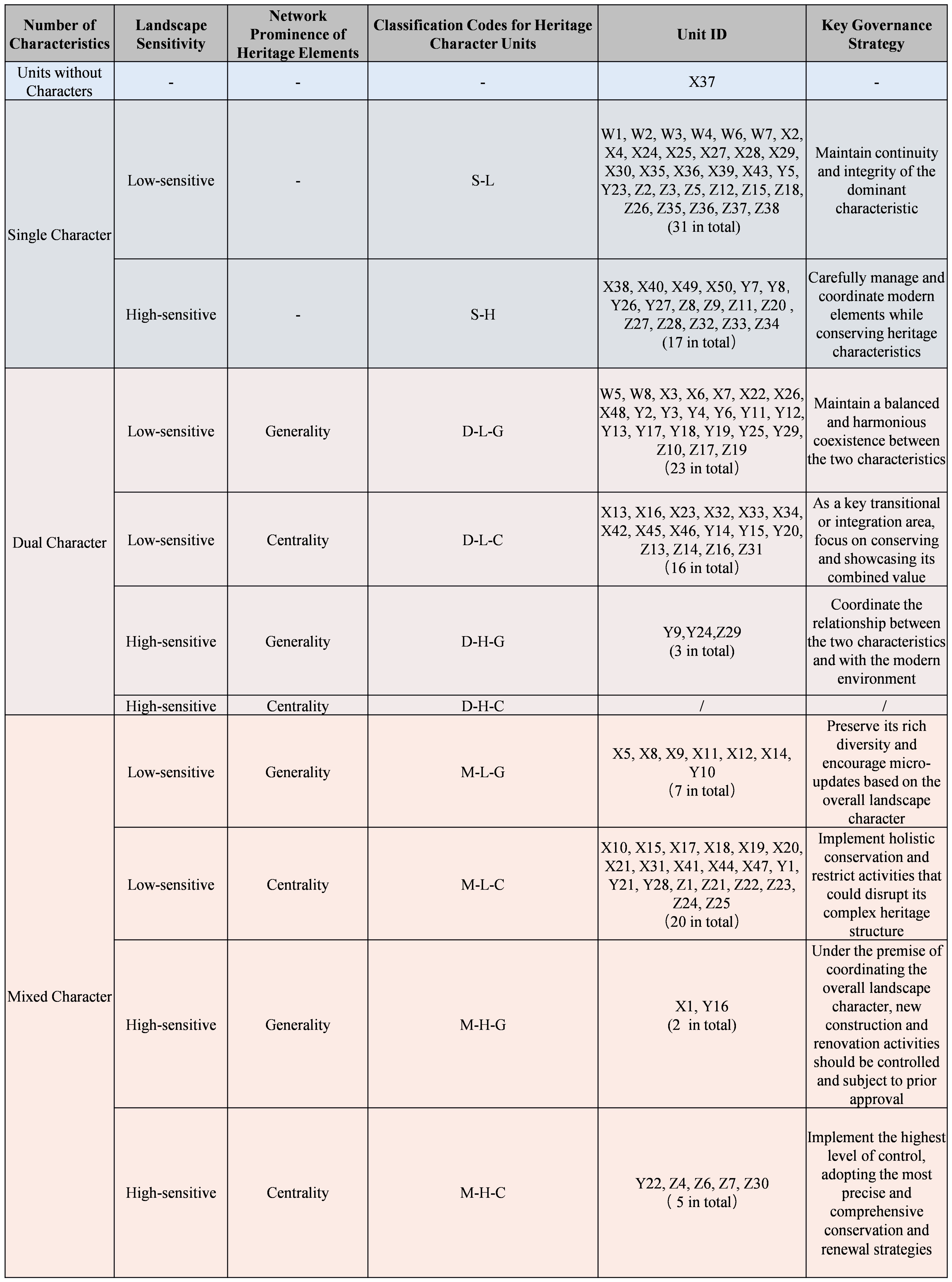
This study proposes a hierarchical and differentiated framework for heritage conservation and governance (Figure 11).
Figure 11. Classification results of character units and key governance strategies. Character units are categorized into ten types: S-L, S-H, D-L-G, D-L-C, D-H-G, D-H-C, M-L-G, M-L-C, M-H-G, and M-H-C. Here, S = single-character unit, D = dual-character unit, M = mixed-character unit; L = low-sensitivity landscape, H = high-sensitivity landscape; G = generality, and C = centrality. Corresponding development and governance strategies are proposed for each category.
Specifically, regarding Heritage Richness, strategies for Single-Character Units (predominantly identified in the Unit X30) should prioritize the in situ preservation of core elements—such as the natural landscapes of Wulong Mountain and Foyin Lake—to safeguard their physical integrity and historical continuity. Conversely, Dual- and Multi-Character Units (primarily concentrated in the town center, such as Unit X22), our analysis reveals a critical spatial overlap of diverse heritage components, including the Imperial Kiln site, official administrative institutions, and the natural mountainous topography. Past planning frameworks have largely overlooked both the structural interdependencies and the equal heritage significance of these overlapping elements. Recognizing and preserving this complex integration is now paramount, and future governance must emphasize this holistic approach to prevent the fragmentation of the heritage network.
Secondly, mapped landscape sensitivity directly dictates intervention intensity. in terms of landscape sensitivity, Low-sensitivity units, which our spatial analysis reveals to have maintained high structural integrity (such as X44) should undergo strict protection and controlled restoration, prioritizing the maintenance of authenticity and integrity, while adopting an anchor-based renewal strategy that allows incremental updates or functional replacement of non-core elements under the premise of preserving key structural components. In contrast, high-sensitivity units—such as Unit Z10, which occupies the critical spatial interface between the historic core and the new urban development zone—require prioritized intervention. In these boundary areas, specific fabric repair and morphology guidance are essential to mitigate external developmental pressures. For example, local kiln brick masonry can be incorporated into the primary street-facing facades of modern buildings to ensure visual and textural continuity with the historic environment [54,55]. For the identified M-H-C units—specifically Unit Z7, which represents the most vulnerable yet valuable area—the highest level of governance is required. Our analysis indicates that this unit suffers from the encroachment of modern residential developments, internal community hollowing-out, and the widespread abandonment of historical structures, particularly the traditional Dubang kiln houses (Duchang guild workshops) which currently lack maintenance and management. To address these specific vulnerabilities, targeted adaptive reuse and spatial integration strategies must be employed to promote community integration and social recognition, thereby repairing the historical fabric fragmented by excessive development [56].
Thirdly, regarding Value Centrality, conservation strategies must transcend the static protection of solitary buildings to prioritize the resilience of relational networks. High-centrality units (such as Units X23, X32, X33, and X34), acting as pivotal nodes within the interconnected network of official kiln production, folk living, and local belief systems, necessitate a holistic approach. This approach must safeguard their functional connectivity and socio-spatial ties with surrounding artisan workshops and the developed Taoyangli tourism district. To achieve sustainable adaptive reuse, management strategies should strongly encourage multi-stakeholder participation in curating thematic exhibitions of the historical assets within these zones. By transforming these pivotal nodes into collaborative cultural showcases, they can maintain their active role in bridging traditional production with contemporary community vitality. Conversely, for units exhibiting lower centrality, interventions must focus on adaptive reuse of historical buildings. By fostering new functional linkages—such as introducing small-scale retail shops, cafes, bookstores, and boutique artisan workshops—these peripheral units can attract foot traffic and reinforce the overall socio-economic vitality of the historic district.
Finally, from the perspective of visual integrity, the proliferation of high-rise buildings since the late twentieth century has fragmented the landscape, causing even irrecoverable losses in the traditional character of high-value streetscapes [57]. In this context, digital reconstruction has become an important means to compensate for these losses. Immersive technologies such as virtual reality (VR) and augmented reality (AR) can recreate vanished historical scenes and preserve them within digital spaces [58,59]. Furthermore, integrating virtual landscapes with physical spaces—by embedding digital display nodes in historical sites, redevelopment areas, or cultural tourism routes—can establish a ‘virtual–real’ dual narrative within the urban environment. This approach not only aids in restoring the holistic perception of the heritage environment but also offers new mediums and methods for mediating between contemporary landscapes and historical memory.

4.3. Implications and Limitations of the Zoning Framework

Although the zoning framework proposed in this study is based on the Jingdezhen case, the overarching model demonstrates strong transferability. It is equally applicable to regions characterized by multiple historical layers and a rich diversity of heritage elements. However, when applied across different geographical contexts, the specific evaluation indicators must be tailored to the unique heritage values and local contexts of the target area.
Nevertheless, this study is subject to several limitations. First, the quantitative framework relies heavily on the accessibility and classification accuracy of heritage datasets, yet the degree of data standardization often varies significantly across different cities. Second, owing to constraints in data acquisition, the current indicator system does not yet incorporate dimensions such as residents’ perceptions of place and dynamic socioeconomic data. These limitations highlight critical avenues for future research, where the zoning model can be further refined through the integration of multi-source data.

5. Conclusions

Using the historic urban area of Jingdezhen as a case study, this research establishes a novel framework for heritage character-based zoning. Compared with traditional static buffer-zone approaches, the proposed framework provides a more refined and operational spatial management strategy.
Notably, building upon existing zoning frameworks (i.e., construction control zones, buffer zones, and core heritage areas), this study adopts the block as the basic unit to enable more refined identification of historic urban landscape elements, visualization of heritage co-occurrence networks, and character-based zoning and management. At the same time, the study highlights the critical tension between heritage conservation and modern urban growth. It further delineates conflict boundaries and identifies key conflict elements, particularly kiln-related guild heritage features and high-rise buildings. These conflict interfaces represent priority areas for managing change and should be given particular attention in future adaptive conservation and spatial planning strategies.
In conclusion, this framework provides a scientific basis for the precise management of change and establishes a physical data foundation for the subsequent integration of resident perception research. It also offers methodological transferability for other historic cities facing the complexities of heritage-led urban regeneration.

Author Contributions

Conceptualization, D.H. and Y.Z.; methodology, Y.Z.; software, Y.Z. and L.W.; validation, Y.Z., L.W. and D.H.; formal analysis, Y.Z.; investigation, Y.Z. and L.W.; resources, D.H.; data curation, Y.Z. and L.W.; writing—original draft preparation, Y.Z.; writing—review and editing, D.H. and Y.Z.; visualization, Y.Z.; supervision, D.H.; project administration, D.H.; funding acquisition, D.H. All authors have read and agreed to the published version of the manuscript.

Funding

This research was funded by the Natural Science Foundation of China, grant numbers 52378002.

Data Availability Statement

The data used in this study are available from the corresponding author upon reasonable request.

Conflicts of Interest

The authors declare no conflicts of interest.

Appendix A

Table A1. FAHP Fuzzy Complementary Matrix R (Single Expert Assessment).
Table A2. Characteristic Matrix E (Aggregated Results of Five Experts).

References

  1. Hanif, A.; Zakiri, J.A.; Mirzahi, S.; Asim, G.M.; Nadeem, G.F. Analysis of contextual factors influencing the development of unplanned settlements: The case of Herat City, Afghanistan. City Cult. Soc. 2024, 39, 100607. [Google Scholar] [CrossRef] [Scilit]
  2. Ginzarly, M.; Houbart, C.; Teller, J. The Historic Urban Landscape approach to urban management: A systematic review. Int. J. Herit. Stud. 2018, 25, 999–1019. [Google Scholar] [CrossRef] [Scilit]
  3. Pereira Roders, A.; Van Oers, R. Wedding cultural heritage and sustainable development: Three years after. J. Cult. Herit. Manag. Sustain. Dev. 2014, 4, 2–15. [Google Scholar] [CrossRef] [Scilit]
  4. Ripp, M.; Gustafsson, C.; Jones, Z.; Majumdar, S.; Ginzarly, M. Historic Urban Landscapes and Heritage Systems as the Basis for Sustainable Urban Development. Land 2025, 14, 1783. [Google Scholar] [CrossRef] [Scilit]
  5. Shan, C.; Yang, R.; Feng, J. A Study on the Spatial Narrative of Historical Urban Landscape Based on Water–Land Symbiosis: The Case of Suzhou Ancient City in China. Land 2025, 14, 2413. [Google Scholar] [CrossRef] [Scilit]
  6. Li, X.; Zhang, Y. Urban Morphology and Historical Urban Landscape Conservation and Management. In Conserving and Managing Historical Urban Landscape: An Integrated Morphological Approach; Li, X., Zhang, Y., Eds.; Springer Nature: Singapore, 2022; pp. 7–32. [Google Scholar]
  7. Cai, R.; Nasu, S. Adopting the ‘historic layering’ concept from the Historic Urban Landscape approach as a methodological framework for urban heritage conservation. Int. J. Herit. Stud. 2025, 31, 573–591. [Google Scholar] [CrossRef] [Scilit]
  8. Wang, Y.; Jin, C.; Xu, D.; Wang, T.; Wang, B. Analysis of Multi-Dimensional Layers in Historic Districts Based on Theory of the Historic Urban Landscape: Taking Shenyang Fangcheng as an Example. Land 2024, 13, 1736. [Google Scholar] [CrossRef] [Scilit]
  9. De Rosa, F.; Di Palma, M. Historic Urban Landscape Approach and Port Cities Regeneration: Naples between Identity and Outlook. Sustainability 2013, 5, 4268–4287. [Google Scholar] [CrossRef] [Scilit]
  10. Colavitti, A.M.; Floris, A.; Serra, S. Challenges and Opportunities for the Historic Urban Landscape Planning. The Sardinia Region Case Study. In Computational Science and Its Applications–ICCSA 2020; Springer: Cham, Switzerland, 2020; Volume 12255, pp. 407–421. [Google Scholar]
  11. Höftberger, K. Conservation and development: Implementation of the historic urban landscape approach in Khiva, Uzbekistan. Int. J. Herit. Stud. 2023, 29, 314–328. [Google Scholar] [CrossRef] [Scilit]
  12. Bahrami, B.; Samani, F.A.E. Reconnecting the Landscape in Historical Cities, Conceptual Analysis of Historic Urban Landscape Approach in Iran. Curr. World Environ. 2015, 10, 456–466. [Google Scholar] [CrossRef] [Scilit]
  13. Sun, J.; Shao, L. Interpretation of Historic Urban Landscape Genes: A Case Study of Harbin, China. Land 2024, 13, 1988. [Google Scholar] [CrossRef] [Scilit]
  14. Pei, Y.; Yang, R.; Dang, A. Interpretation of the Historic Layering Process and Value Assessment of Yulin Ancient City Based on the Historic Urban Landscape Approach. Urban Dev. Stud. 2022, 29, 128–136. [Google Scholar]
  15. Wang, Y.; Jin, C.; Wang, T.; Xu, D. The Interpretation of Historical Layer Evolution Laws in Historic Districts from the Perspective of the Historic Urban Landscape: A Case Study in Shenyang, China. Land 2025, 14, 1029. [Google Scholar] [CrossRef] [Scilit]
  16. He, D.; Yuan, L.; Chen, W. The connections between Historic Urban Landscape layers in Jingdezhen, the porcelain capital of China. Landsc. Res. 2023, 49, 393–409. [Google Scholar] [CrossRef] [Scilit]
  17. Liu, P. Fine-Grained Land-Use Zoning: A Patch-Based Spatial Repair Strategy for Historic Urban Areas. Urban Plan. Forum 2018, 106–113. [Google Scholar] [CrossRef]
  18. Dong, Y.; Han, D. Land Parcel Classification in the Practice of Historic Site Conservation and Regeneration: A Case Study of Xiaoxihu District in Nanjing. Architect 2022, 55–61. [Google Scholar] [CrossRef]
  19. UNESCO. Recommendation on the Historic Urban Landscape; UNESCO: Paris, France, 2011. [Google Scholar]
  20. Mansour, A. Heritage conservation ideologies analysis–Historic urban Landscape approach for a Mediterranean historic city case study. HBRC J. 2017, 14, 345–356. [Google Scholar] [CrossRef] [Scilit]
  21. Khalaf, R. Integrity: Enabling a Future-Oriented Approach to Cultural Heritage. Hist. Environ. Policy Pract. 2021, 13, 5–27. [Google Scholar] [CrossRef] [Scilit]
  22. UNESCO. Operational Guidelines for the Implementation of the World Heritage Convention; UNESCO: Paris, France, 2005. [Google Scholar]
  23. Ji, X. Research on the Perception and Conservation of the Dynamic Integrity of Historic Urban Landscapes. Ph.D. Thesis, Harbin Institute of Technology, Harbin, China, 2020. [Google Scholar]
  24. Zancheti, S.; Piccolo, R. Dynamic integrity: A concept to historic urban landscape. J. Cult. Herit. Manag. Sustain. Dev. 2015, 5, 82. [Google Scholar] [CrossRef] [Scilit]
  25. Li, K. Exploration of Adaptation in Historic Residential Districts from the Perspective of Dynamic Integrity: Oriented Towards Promoting the Physical and Mental Health of the Elderly. In Proceedings of the 2025 Annual National Planning Conference of China, Shenyang, China, 5–11 March 2025; p. 13. [Google Scholar]
  26. Sharma, V.; Dua, S. Visual investigations of urban design in historic cities: The case of Anandpur Sahib, Punjab, India. Landsc. Res. 2025, 50, 622–639. [Google Scholar] [CrossRef] [Scilit]
  27. Yan, C. The Beginning: Legend of Tong Bin, the Kiln God. In A Brief History of Chinese Imperial Porcelain; Palgrave Macmillan: Singapore, 2024; pp. 17–19. [Google Scholar]
  28. Wu, S. The “Humanization” of Landscape and the “Imaginary Body” of Man in Northern Song Landscape Paintings—The Pine Tree as a Path of Interpretation. Commun. Humanit. Res. 2025, 100, 256–263. [Google Scholar] [CrossRef] [Scilit]
  29. Mi, C.; Abdul Hadi, H.; Ismail, I. The Beauty of Daoist Philosophy in Chinese Landscape Painting; EAI (European Alliance for Innovation): Bratislava, Slovakia, 2025. [Google Scholar]
  30. Tobiáš, P.; Cajthaml, J.; Krejčí, J. Rapid reconstruction of historical urban landscape: The surroundings of Czech chateaux and castles. J. Cult. Herit. 2017, 30, 1–9. [Google Scholar] [CrossRef] [Scilit]
  31. Huang, Y.; Yang, S. Mapping Suzhou’s Cultural Heritage Sites: Exploring Gusu Prosperous Map through Data Visualization. J. Comput. Cult. Herit. 2025, 18, 1–26. [Google Scholar] [CrossRef] [Scilit]
  32. Bai, X.; Jiao, X.; Sakai, T.; Xu, H. Mapping the past with historical geographic information systems: Layered characteristics of the historic urban landscape of Nanjing, China, since the Ming Dynasty (1368–2024). Herit. Sci. 2024, 12, 283. [Google Scholar] [CrossRef] [Scilit]
  33. Dong, S.; Shen, D. A Study of Historical Urban Landscape Layering in Luoyang Based on Historical Map Translation. Land 2023, 12, 663. [Google Scholar] [CrossRef] [Scilit]
  34. Cazzani, A.; Zerbi, C.; Brumana, R.; Lobovikov-Katz, A. Raising awareness of the cultural, architectural, and perceptive values of historic gardens and related landscapes: Panoramic cones and multi-temporal data. Appl. Geomat. 2020, 14, 97–130. [Google Scholar] [CrossRef] [Scilit]
  35. Li, X.; Zhou, X.; Weng, F.; Ding, F.; Wu, Y.; Yi, Z. Evolution of cultural landscape heritage layers and value assessment in urban countryside historic districts: The case of Jiufeng Sheshan, Shanghai, China. Herit. Sci. 2024, 12, 96. [Google Scholar] [CrossRef] [Scilit]
  36. Fairclough, G.; Herring, P. Lens, mirror, window: Interactions between Historic Landscape Characterisation and Landscape Character Assessment. Landsc. Res. 2016, 41, 186–198. [Google Scholar] [CrossRef] [Scilit]
  37. Stanik, N.; Aalders, I.; Miller, D. Towards an indicator-based assessment of cultural heritage as a cultural ecosystem service—A case study of Scottish landscapes. Ecol. Indic. 2018, 95, 288–297. [Google Scholar] [CrossRef] [Scilit]
  38. Chang, D.-Y. Applications of the extent analysis method on fuzzy AHP. Eur. J. Oper. Res. 1996, 95, 649–655. [Google Scholar] [CrossRef] [Scilit]
  39. Vinogradova-Zinkevič, I. Comparative Sensitivity Analysis of Some Fuzzy AHP Methods. Mathematics 2023, 11, 4984. [Google Scholar] [CrossRef] [Scilit]
  40. Lin, Z.; Li, D. Spatial distribution characteristics and influencing factors of defensive traditional villages in the Taihang Mountain Area. npj Herit. Sci. 2025, 13, 565. [Google Scholar] [CrossRef] [Scilit]
  41. Guo, C.; Jin, L.; Li, Y.; Zeng, W. A study on the spatial distribution and historical evolution of spirit road stone carvings in the ancient capital of Nanjing and its surrounding areas. npj Herit. Sci. 2025, 13, 455. [Google Scholar] [CrossRef] [Scilit]
  42. Li, K.; Huang, Z.; Pang, Y.; Chen, S.; Fan, Y.; Yin, M.; Shi, C. Cultural heritage of the Qin-Shu Ancient Road in Shaanxi: Spatial distribution characteristics and influencing factors. PLoS ONE 2025, 20, e0331676. [Google Scholar] [CrossRef] [Scilit]
  43. Ma, Y.; Zhang, Y.; Wang, F.; He, J.; Gong, Y.; Liu, Y. Where is Huaqiangbei? Identifying the evolutional vague region of urban business district using toponym co-occurrence on web pages with multiple time series. Cartogr. Geogr. Inf. Sci. 2025, 1–24. [Google Scholar] [CrossRef] [Scilit]
  44. Silverman, B.W. Density Estimation for Statistics and Data Analysis; Chapman & Hall: New York, NY, USA, 1987. [Google Scholar]
  45. Xu, R.; Chen, Z.; Li, F.; Zhou, C. Identification of Urban Functional Zones Based on POI Density and Marginalized Graph Autoencoder. ISPRS Int. J. Geo-Inf. 2023, 12, 343. [Google Scholar] [CrossRef] [Scilit]
  46. Chen, Y.; Yang, J.; Yang, R.; Xiao, X.; Xia, J. Contribution of urban functional zones to the spatial distribution of urban thermal environment. Build. Environ. 2022, 216, 109000. [Google Scholar] [CrossRef] [Scilit]
  47. Baronchelli, A.; Ferrer-i-Cancho, R.; Pastor-Satorras, R.; Chater, N.; Christiansen, M. Networks in Cognitive Science. Trends Cogn. Sci. 2013, 17, 348–360. [Google Scholar] [CrossRef] [Scilit] [PubMed]
  48. Gong, Z.; Zhang, Z.; Zhou, J.; Zhou, J.; Wang, W. The Evolutionary Process and Mechanism of Cultural Landscapes: An Integrated Perspective of Landscape Ecology and Evolutionary Economic Geography. Land 2022, 11, 2062. [Google Scholar] [CrossRef] [Scilit]
  49. Sarihan, E.; Lovra, É. Uncovering Urban Palimpsest through Descriptive and Analytical Approaches to Urban Morphology—Understanding the Ottoman Urban Fabric of Bursa, Türkiye. Land 2024, 13, 1435. [Google Scholar] [CrossRef] [Scilit]
  50. Polyzoudi, A. Archaeological Heritage as Palimpsest. The Multiple Layers of Contents of a Byzantine Tower and the Challenges of Sustainable Management Planning. Hist. Environ. 2013, 4, 129–138. [Google Scholar] [CrossRef] [Scilit]
  51. Rebollo Díaz, V. Good Practices in Building Cultural Heritage Resilience; ARCH: St. Louis, MO, USA, 2020. [Google Scholar]
  52. Yan, C. Imperial Kiln on the Wane. In A Brief History of Chinese Imperial Porcelain; Palgrave Macmillan: Singapore, 2024; pp. 363–386. [Google Scholar]
  53. Xu, W.; Qin, D.; Weng, Y.; Xianping, G.; Ding, Y. Blurred boundaries: Exploring the complexity of the production system at the Luomaqiao kiln in Yuan-dynasty Jingdezhen. J. Archaeol. Sci. 2025, 181, 106328. [Google Scholar] [CrossRef] [Scilit]
  54. Wang, Z.; Sun, H.; Li, J. Research on Architectural Color and Visual Comfort in Historic Landscape Areas. Buildings 2023, 13, 1004. [Google Scholar] [CrossRef] [Scilit]
  55. Zhang, Y.; Wang, P.; Wei, W.; Wang, Z. How to Construct an Urban Color System? Taking the Historic Center of Macau as an Example. Buildings 2024, 14, 2874. [Google Scholar] [CrossRef] [Scilit]
  56. Ma, X.; Sun, J. A Study of Historic Urban Landscape Change Management Based on Layered Interpretation: A Case Study of Dongxi Ancient Town. Land 2024, 13, 2116. [Google Scholar] [CrossRef] [Scilit]
  57. Ashrafi, B.; Kloos, M.; Neugebauer, C. Heritage Impact Assessment, beyond an Assessment Tool: A comparative analysis of urban development impact on visual integrity in four UNESCO World Heritage Properties. J. Cult. Herit. 2021, 47, 199–207. [Google Scholar] [CrossRef] [Scilit]
  58. Rusak, M.; Kilijańska, B.; Garaszczuk, I.; Duchowski, A.; Biegańska, M.; Dobrasiak, D.; Koszewicz, Z. From eye-tracking to games: Exploring low-tech solutions for sustainable cultural landscape management. J. Cult. Herit. 2025, 74, 225–235. [Google Scholar] [CrossRef] [Scilit]
  59. Arlt, T.; Kantzenbach, B. Revealing the history of a Mongolian shrine by virtually unrolling Buddhist Dharanis. J. Cult. Herit. 2025, 74, 190–194. [Google Scholar] [CrossRef] [Scilit]
Disclaimer/Publisher’s Note: The statements, opinions and data contained in all publications are solely those of the individual author(s) and contributor(s) and not of MDPI and/or the editor(s). MDPI and/or the editor(s) disclaim responsibility for any injury to people or property resulting from any ideas, methods, instructions or products referred to in the content.

Article Metrics

Citations

Article Access Statistics

Multiple requests from the same IP address are counted as one view.