
The Land-Use and Land-Cover Changes in the Este District, South Gondar Zone, Northwestern Ethiopia, in the Last Four Decades (the 1980s to 2020s)


Abstract
1. Introduction
2. Materials and Methods
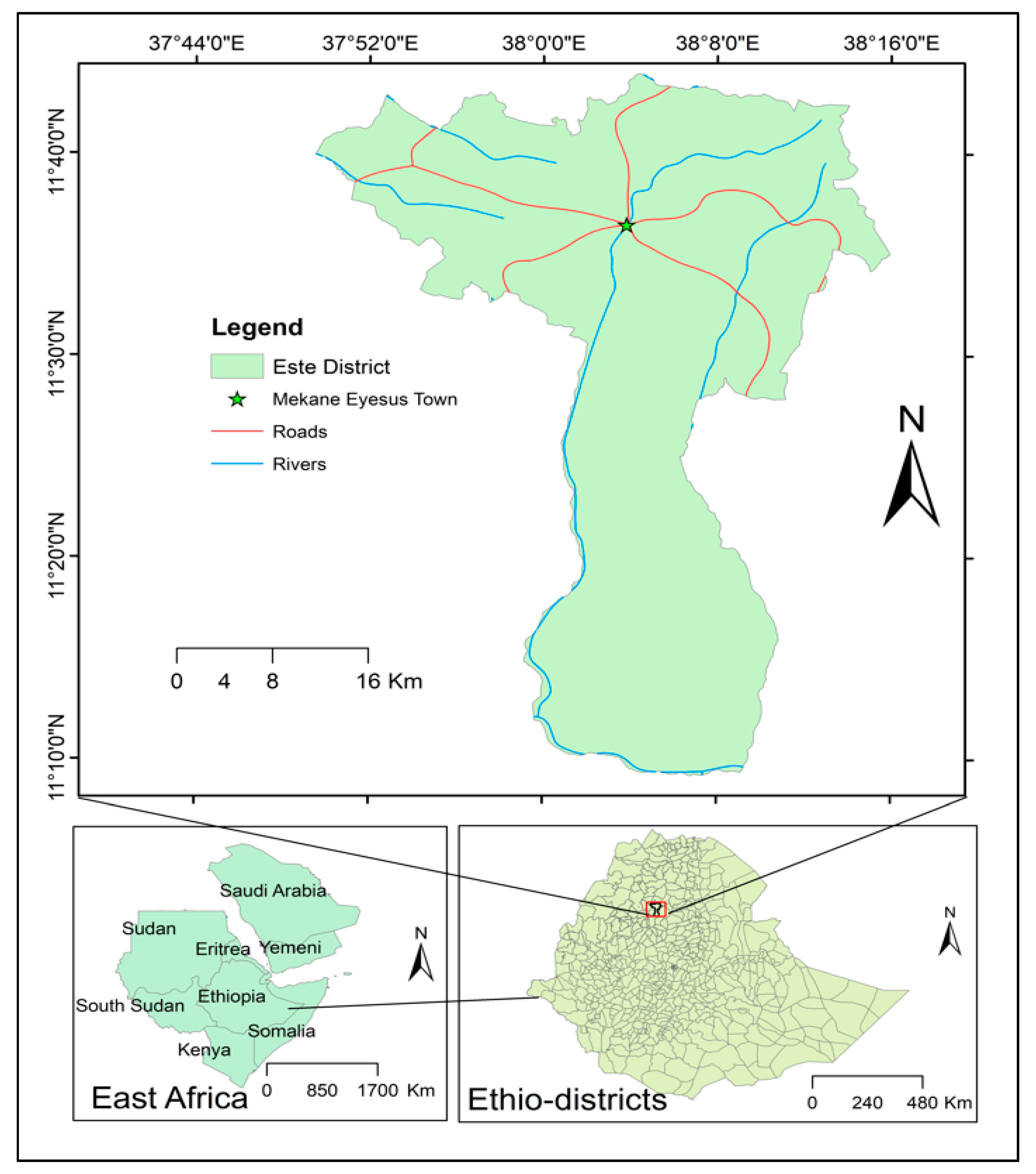
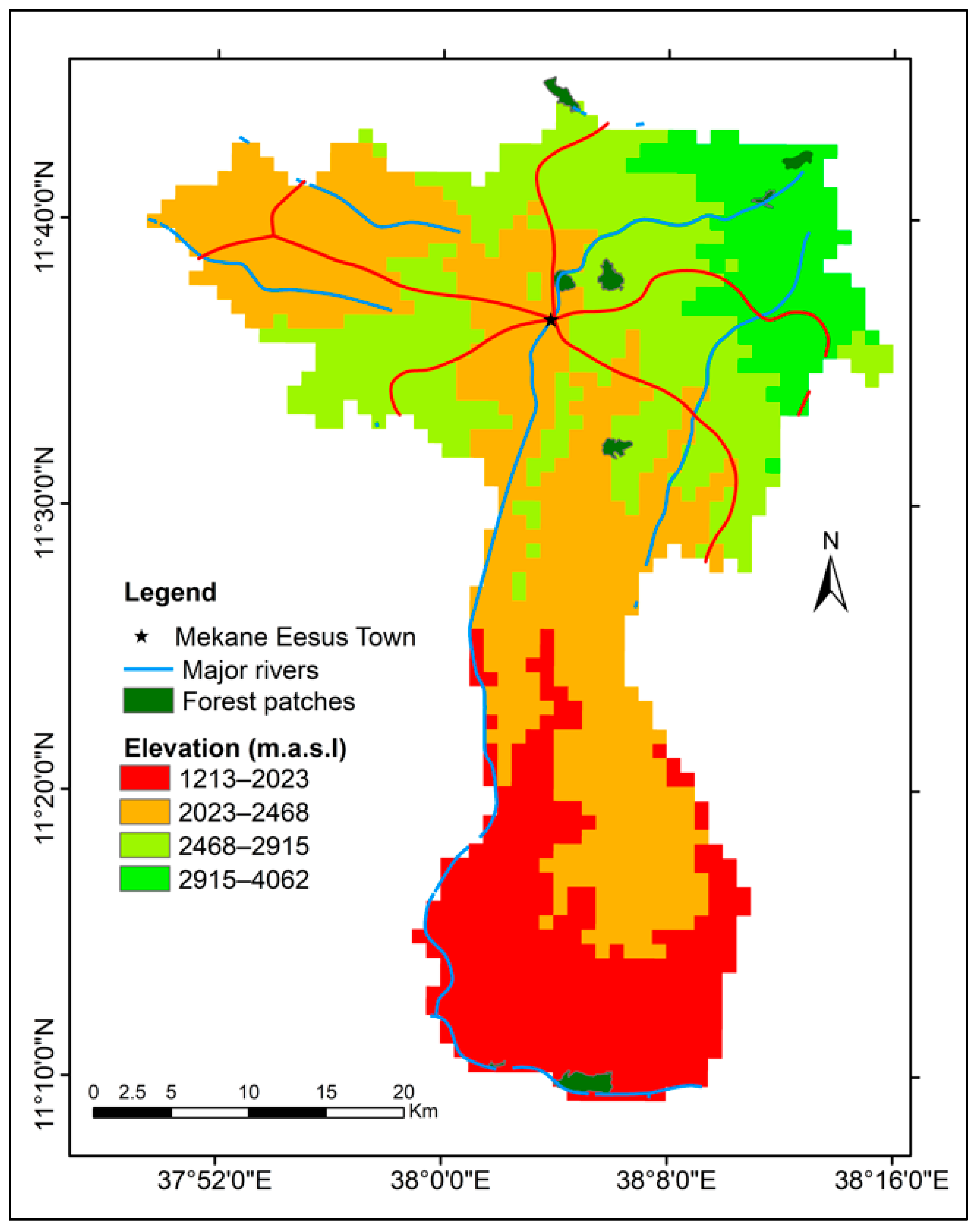
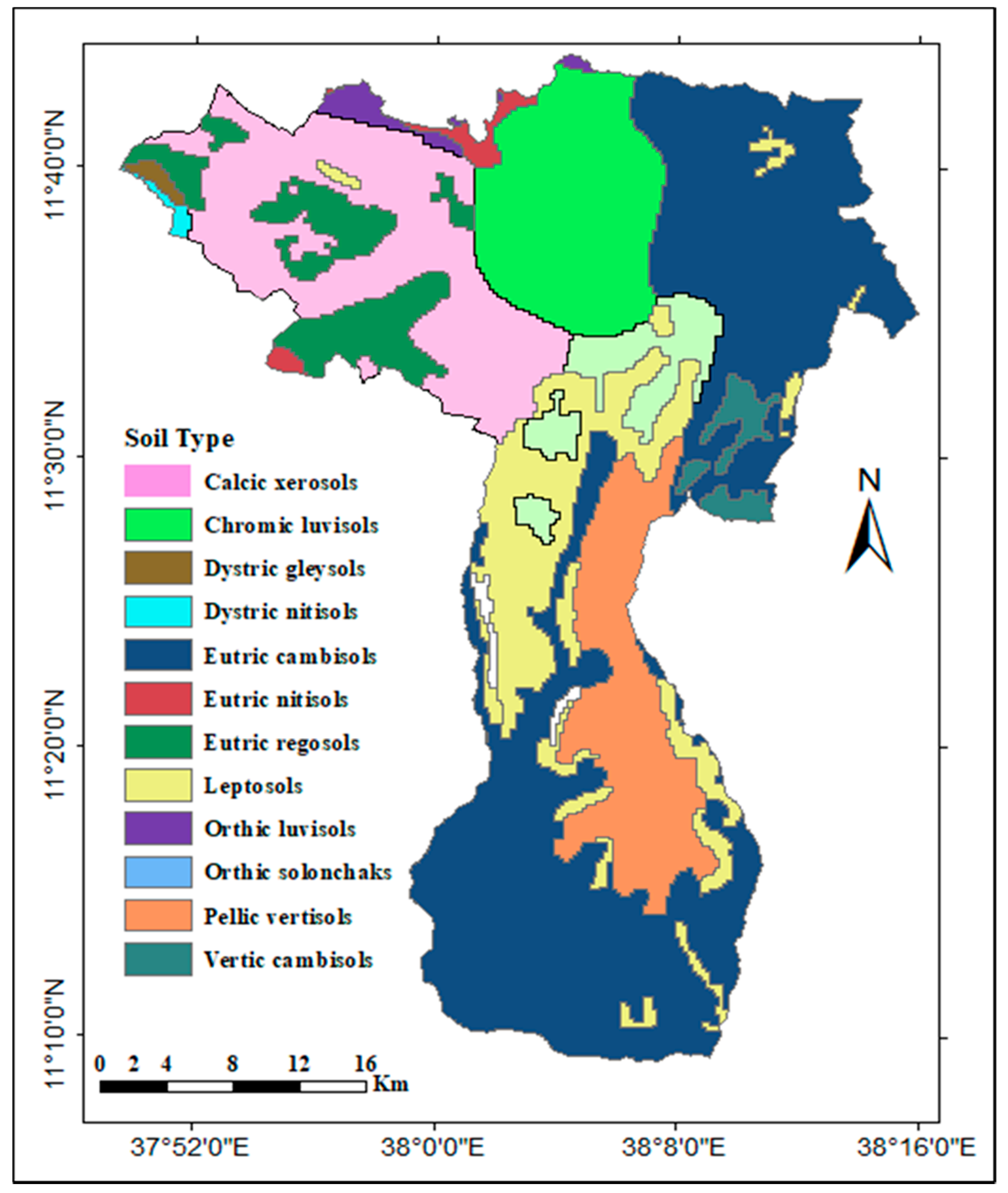
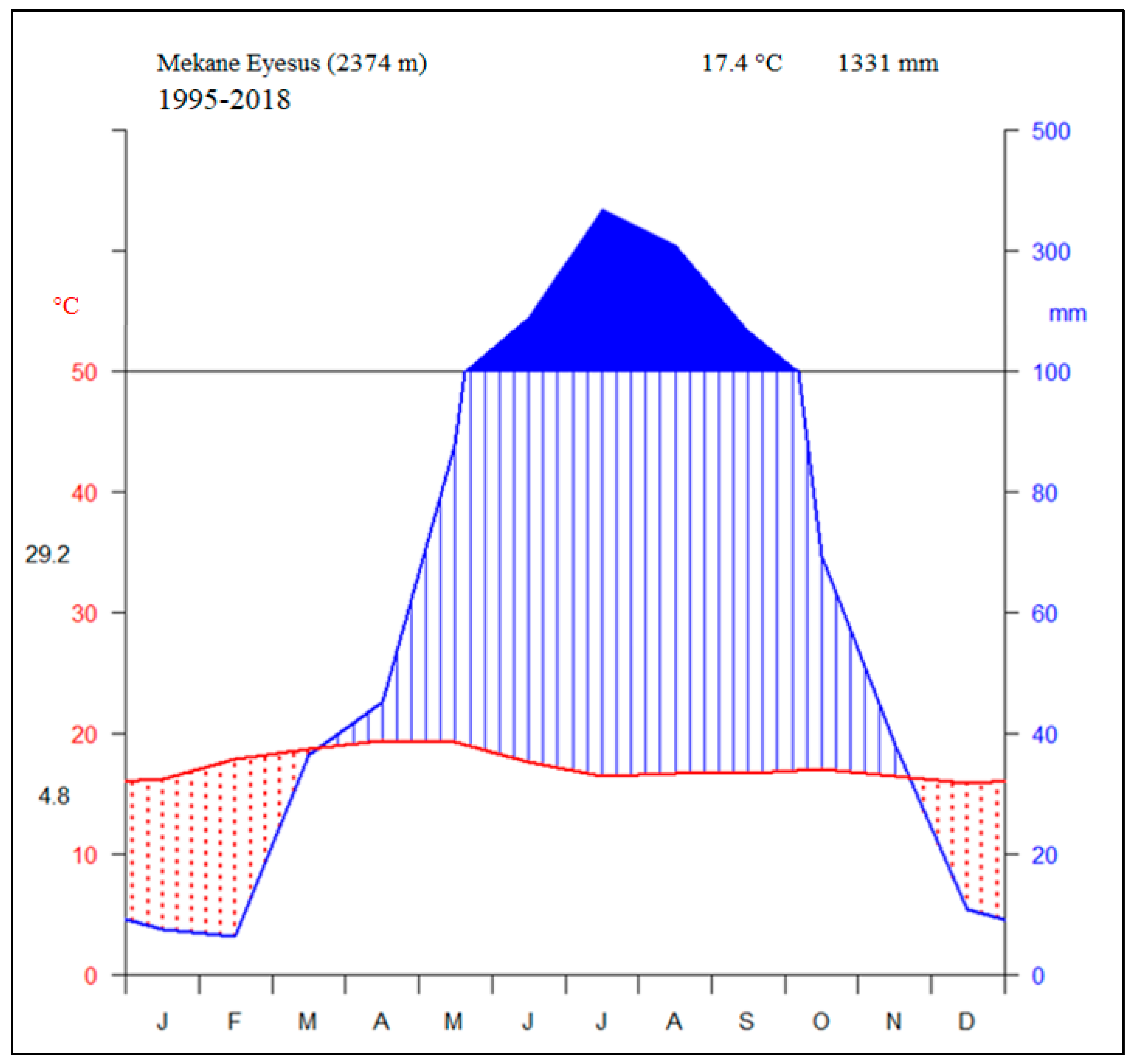
2.1. Descriptions of the Study Area
2.2. Data Collections
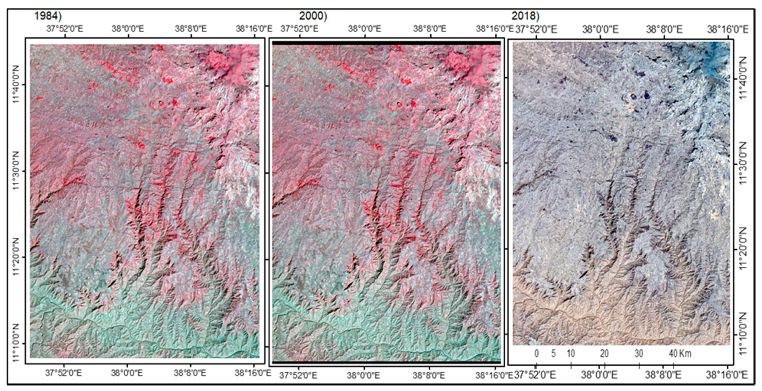
2.2.1. Pre-Classification
2.2.2. Classifications
2.2.3. The Verification and Clipping Processes
2.2.4. Causes, Derivers, and Perceptions of Population to the LULC Changes in the Study Area
2.3. Data Analysis
3. Results
3.1. The Accuracy Assessment
3.2. LULC Classes of Este District in the Last Four Decades
3.3. Land-Use and Land-Cover Change Rates in Este District
3.4. The Potential Causes of the LULC Changes in Este District
3.5. The Experiences and Perceptions of Local People towards the LULC Changes
4. Discussion
5. Conclusions and Recommendations
Author Contributions
Funding
Institutional Review Board Statement
Informed Consent Statement
Data Availability Statement
Acknowledgments
Conflicts of Interest
References
- Lambin, E.F.; Geist, H.J.; Lepers, E. Dynamics of land-use and land-cover change in tropical regions. Annu. Rev. Environ. Resour. 2003, 28, 205–241. [Google Scholar] [CrossRef]
- Roy, P.S.; Roy, A. Land-use and land-cover change: A remote sensing & GIS perspective. J. Indian Inst. Sci. 2010, 90, 489–502. Available online: https://www.researchgate.net/publication/235987981 (accessed on 21 February 2019).
- Britz, W.; Verburg, P.H.; Leip, A. Modeling of land cover and agricultural change in Europe: Combining the CLUE and CAPRI-Spat approaches. Agric. Ecosyst. Environ. 2011, 142, 40–50. [Google Scholar] [CrossRef]
- Fox, J.; Vogler, J.B. Land-use and land-cover change in Montane Mainland Southeast Asia. Environ. Manag. 2005, 36, 394–403. [Google Scholar] [CrossRef]
- Hassan, Z.; Shabbir, R.; Ahmad, S.S.; Malik, A.H.; Aziz, N.; Butt, A. Dynamics of land-use and land-cover change (LULCC) using geospatial techniques: A case study of Islamabad Pakistan. SpringerPlus 2016, 5, 812. [Google Scholar] [CrossRef]
- Singh, M.; Gairola, S. Land-use/land-cover change detection using geospatial technique: A case study of Sahaspur Block in Dehradun District (Uttarakhand). Int. J. Sci. Res. Sci. Eng. Technol. 2015, 4, 4–7. [Google Scholar]
- Goldewijk, K.; Ramankutty, N. Land-cover change over the last three centuries due to human activities: The availability of new global data sets. GeoJournal 2004, 61, 335–344. [Google Scholar] [CrossRef]
- Bodart, C.; Brink, A.B.; Donnay, F.; Lupi, A.; Mayaux, P.; Achard, F. Continental estimates of forest cover and forest cover changes in the dry ecosystems of Africa between 1990 and 2000. J. Biogeogr. 2013, 40, 1036–1047. [Google Scholar] [CrossRef]
- Koranteng, A.; Adu-poku, I.; Donkor, E.; Zawiła-niedźwiecki, T. Geospatial assessment of land-use and land-cover dynamics in the mid-zone of Ghana. Folia For. Pol. 2020, 62, 288–305. [Google Scholar] [CrossRef]
- Liu, X.; Ren, L.; Yuan, F.; Singh, V.P.; Fang, X.; Yu, Z.; Zhang, W. Quantifying the effect of land-use and land-cover changes on green water and blue water in northern part of China. Hydrol. Earth Syst. Sci. 2009, 13, 735–747. [Google Scholar] [CrossRef]
- Mukherjee, S.; Bebermeier, W.; Schütt, B. An overview of the impacts of land-use land-cover changes (1980–2014) on urban water security of Kolkata. Land 2018, 7, 91. [Google Scholar] [CrossRef]
- Shiferaw, A.; Abate, S. Evaluating the land-use and land-cover Dynamics in Borena Woreda of South Wollo Highlands, Ethiopia. J. Sustain. Dev. Afr. 2011, 13, 87–107. [Google Scholar] [CrossRef]
- Tully, K.; Sullivan, C.; Weil, R.; Sanchez, P. The state of soil segradation in Sub-Saharan Africa: Baselines, trajectories, and solutions. Sustainability 2015, 7, 6523–6552. [Google Scholar] [CrossRef]
- Bajocco, S.; de Angelis, A.; Perini, L.; Ferrara, A.; Salvati, L. The impact of land-use/land-cover changes on land degradation dynamics: A Mediterranean case study. Environ. Manag. 2012, 49, 980–989. [Google Scholar] [CrossRef]
- Haines-Young, R. Land-use and biodiversity relationships. Land-Use Policy 2009, 26, 178–186. [Google Scholar] [CrossRef]
- Alewell, C.; Ballabio, C.; Ferro, V.; Robinson, D.A.; Panagos, P.; Borrelli, P.; Lugato, E.; Oost, K.V.; Schütt, B.; Fleischer, L.R.; et al. An assessment of the global impact of 21st century land-use change on soil erosion. Nat. Commun. 2017, 8, 1–13. [Google Scholar] [CrossRef]
- Biazin, B.; Sterk, G. Drought vulnerability drives land-use and land cover changes in the Rift Valley drylands of Ethiopia. Agric. Ecosyst. Environ. 2013, 164, 100–113. [Google Scholar] [CrossRef]
- Mengistie, K.; Schneider, T.; Demel, T.; Knoke, T. Drivers of land-use/land-cover changes in Munessa-Shashemene landscape of the south-central highlands of Ethiopia. Environ. Monit. Assess. 2015, 187, 452. [Google Scholar] [CrossRef]
- Belay, T. Land-cover/land-use changes in the Derekolli Catchment of the South Welo Zone of Amhara Region, Ethiopia. East. Afr. Soc. Sci. Res. Rev. 2002, 18, 1–20. [Google Scholar] [CrossRef]
- Dagnenet, F.; Duan, Z.; Rientjes, T.; Markus, D. Analysis of combined and isolated effects of land-use and land-cover changes and climate change on the upper Blue Nile River basin’s streamflow. Hydrol. Earth Syst. Sci. 2018, 22, 6187–6207. [Google Scholar]
- Temesgen, G.; Amare, B.; Abraham, M. Population dynamics and land-use/land-cover changes in Dera District, Ethiopia. Glob. J. Biol. Agric. Health Sci. 2014, 3, 137–140. [Google Scholar]
- Yilmaz, S.; Guner, A. Local government discretion and accountability in turkey. Public Admin. Dev. 2006, 33, 125–142. [Google Scholar] [CrossRef]
- United Nations Children’s Fund. Amhara Regional State 2015/16. A Report. 2018. Available online: https://www.unicef.org/esa/media/4261/file/UNICEF-Ethiopia-2018-Amhara-Regional-State-Budget-Brief.pdf (accessed on 6 December 2021).
- Eleni, Y.; Wagner, W.; Exner-kittridge, M.; Dagnachew, L. Identifying land-use/cover Dynamics in the Koga Catchment, Ethiopia, from multi-scale data, and implications for environmental change. ISPRS Int. J. Geo-Inf. 2013, 2, 302–323. [Google Scholar] [CrossRef]
- Central Statistical Agency. Statistical Amhara Part I: Population Size and Characteristics; Administrative Report; Central Statistical Agency: Addis Ababa, Ethiopia, 2012; p. 125. [Google Scholar]
- Friis, I.; Sebsebe, D.; van Breugel, P. Atlas of the potential vegetation of Ethiopia. In The Royal Danish Academy of Sciences and Letters; Selskab, D.V., Nielsen, M.A., Eds.; The Royal Danish Academy of Sciences and Letters: Copenhagen, Denmark, 2010. [Google Scholar] [CrossRef]
- Babykalpana, Y.; ThanushKodi, K. Supervised/unsupervised classification of LULC using remotely sensed data for Coimbatore city, India. Int. J. Comput. Appl. 2010, 2, 26–30. [Google Scholar] [CrossRef]
- Enderle, D.I.M.; Weihjr, R.C. Integrating supervised and unsupervised classification methods to develop a more accurate land-cover classification. J. Ark. Acad. Sci. 2005, 59, 65–73. [Google Scholar]
- Fazzini, M.; Bisci, C.; Billi, P. The Climate of Ethiopia. Landscapes and landforms of Ethiopia; Billi, P., Ed.; Springer Science + Business Media: Dordrech, The Netherland, 2015; pp. 65–87. [Google Scholar] [CrossRef]
- Young, N.E.; Anderson, R.S.; Chignell, S.M.; Vorster, A.G.; Lawrence, R.; Evangelista, P.H. A survival guide to Landsat preprocessing. Ecology 2017, 98, 920–932. [Google Scholar] [CrossRef]
- Mohd, H.L.; Pakhriazad, H.Z.P.; Shahrin, F. Evaluating supervised and unsupervised techniques for land cover mapping using remote sensing data. Geogr. Malays. J. Soc. Space 2009, 5, 1–10. [Google Scholar]
- Amershi, S.; Conati, C.C. Combining unsupervised and supervised classification to build user models for exploratory. JEDM 2009, 1, 18–71. [Google Scholar] [CrossRef]
- Lemenkova, P. Processing remote sensing data using Erdas Imagine for Mapping Aegean Sea Region, Turkey. Informatics 2015, 3, 11–15. Available online: https://elibrary.ru/item.asp?id=26663916 (accessed on 26 February 2019).
- Abineh, T.; Bogale, T. Accuracy assessment of land-use land-cover classification using Google Earth. Am. J. Environ. Prot. 2015, 4, 193–198. [Google Scholar]
- Czaplewski, L. Accuracy assessment of maps of forest condition: Statistical design and methodological considerations. In Remote Sensing of Forest Environments: Concepts and Case Studies; Wulder, M.A., Franklin, S.E., Eds.; Kluwer Academic Publishers: Norwell, MA, USA, 2003; pp. 115–140. [Google Scholar]
- Ismail, M.H.; Jusoff, K. Satellite data classification accuracy assessment based from reference dataset. Int. J. Comp. Inf. Eng. 2008, 2, 23–29. [Google Scholar]
- Chandran, S.; Kim, S.K.; Mount, D.M. Parallel computational geometry of rectangles. Algorithmica 1992, 7, 25–49. [Google Scholar] [CrossRef]
- Huang, H.E.; Witz, K.G. Children’s conceptions of area measurement and their strategies for solving area measurement problems. Curric. Teach 2013, 2, 10–26. [Google Scholar] [CrossRef]
- Cheruto, M.C.; Kauti, M.K.; Kisangau, P.D.; Kariuki, P. Assessment of land-use and land-cover change using GIS and remote sensing techniques: A case study of Makueni County, Kenya. J. Remote Sens. GIS 2016, 5, 1000175. [Google Scholar] [CrossRef]
- Kumar, P.; Rai, A.; Chand, S. Land-use and land-cover change detection using geospatial techniques in the Sikkim Himalaya, India. Egypt. J. Remote. Sens. Space Sci. 2019, 23, 133–143. [Google Scholar] [CrossRef]
- R Core Team. R: A Language and Environment for Statistical Computing, R version 3.4.3; R Foundation for Statistical Computing: Vienna, Australia, 2019; Available online: https://www.r-project.org/ (accessed on 12 March 2018).
- Frank, H.E. Hmisc: Harrell Miscellaneous, R package version 4.2-0; R Foundation for Statistical Computing: Vienna, Australia, 2019; Available online: https://cran.r-project.org/package=Hmisc (accessed on 17 March 2018).
- Franklin, S.E.; Wulder, M.A. Remote sensing method in medium spatial resolution satellite data land cover classification of large areas. Prog. Phys. Geogr. 2002, 26, 173–205. [Google Scholar] [CrossRef]
- Thomlinson, J.R.; Bolstad, P.V.; Cohen, W.B. Coordinating methodologies for scaling cand-cover classifications from Site-Specific to Global: Steps toward validating global map products. Remote Sens. Environ. 1999, 70, 16–28. [Google Scholar] [CrossRef]
- Wijedasa, L.S.; Sloan, S.; Michelakis, D.G.; Clements, G.R. Overcoming limitations with Landsat imagery for mapping of peat swamp forests in Sundaland. Remote Sens. 2012, 4, 2595–2618. [Google Scholar] [CrossRef]
- Manandhar, R.; Odeh, I.O.; Ancev, T. Improving the accuracy of land-use and land-cover classification of Landsat data using post-classification enhancement. Remote Sens. 2009, 1, 330–344. [Google Scholar] [CrossRef]
- Solomon, N.; Hishe, H.; Annang, T.; Pabi, O.; Asante, I.K.; Birhane, E. Forest cover change, key drivers and community perception in Wujig Mahgo Waren forest of northern Ethiopia. Land 2018, 7, 32. [Google Scholar] [CrossRef]
- Woldeamlak, B. Land-cover dynamics since the 1950s in Chemoga Watershed, Blue Nile Basin, Ethiopia. Mt. Res. Dev. 2002, 22, 263–269. [Google Scholar] [CrossRef]
- Hagos, G. Landuse land-cover dynamics of Huluka watershed, Central Rift Valley, Ethiopia. Int. Soil Water Conserv. Res. 2014, 2, 25–33. [Google Scholar] [CrossRef]
- Tatek, B.; Ayalew, D. Land-use and land-cover dynamics and drivers in the Muga watershed, Upper Blue Nile basin, Ethiopia. Remote Sens. Appl. Soc. Environ. 2009, 15, 100249. [Google Scholar] [CrossRef]
- Ramankutty, N.; Mehrabi, Z.; Waha, K.; Jarvis, L.; Kremen, C.; Herrero, M.; Rieseberg, L.H. Trends in global agricultural land-use: Implications for environmental health and food security. Annu. Rev. Plant Biol. 2018, 69, 789–815. [Google Scholar] [CrossRef]
- Sorecha, E.M.; Lenjisa, D. Assessment of plant species diversity, relative abundances and distribution in Haramaya University, Ethiopia. J. Phys. Sci. Environ. Stud. 2017, 3, 30–35. [Google Scholar]
- Skalský, R.; Barančíková, G.; Koco, Š.; Makovníková, J.; Halas, J.; Koleda, P.; Gutteková, M.; Takáč, J. Land-cover and land-use change driven change of regional soil organic carbon storage in croplands and grasslands of North-East Slovakia. Seindo 2020, 39, 159–173. [Google Scholar] [CrossRef]
- Boval, M.; Dixon, R.M. The importance of grasslands for animal production and other functions: A review on management and methodological progress in the tropics. Animal 2012, 6, 748–762. [Google Scholar] [CrossRef] [PubMed]
- Muluneh, A. Synthesis of Research on Land-Use and Land-Cover; UNU-Land Restoration Training Programme: Keldnaholt, Iceland, 2010; pp. 1–39. Available online: https://www.grocentre.is/static/gro/publication/393/document/unu-lrt_2010_alemayehu-muluneh.pdf (accessed on 23 December 2020).
- Negassa, M.D.; Mallie, D.T.; Gemeda, D.O. Forest cover change detection using geographic information systems and remote sensing techniques: A spatio-temporal study on Komto Protected forest priority area, East Wollega Zone, Ethiopia. Environ. Syst. Res. 2020, 9, 1. [Google Scholar] [CrossRef]
- Fasika, A.; Motuma, T.; Gizaw, T. Land Use Land Cover Change Trend and Its Drivers in Somodo Watershed South Western, Ethiopia. Afr. J. Agric. Res. 2019, 14, 102–117. [Google Scholar] [CrossRef]
- Addae, B.; Oppelt, N. Land-use/land-cover change analysis and urban growth modeling in the Greater Accra Metropolitan Area (GAMA), Ghana. Urban Sci. 2019, 3, 26. [Google Scholar] [CrossRef]
- Noda, A.; Kondoh, A.; Nishihiro, J. Changes in land-cover and grassland area over the past 120 years in a rapidly urbanized area in Japan. One Ecosyst. 2019, 4, e37669. [Google Scholar] [CrossRef]
- Leyk, S.; Uhl, J.H.; Connor, D.S.; Braswell, A.E.; Mietkiewicz, N.; Balch, J.K.; Gutmann, M. Two centuries of settlement and urban development in the United States. Sci. Adv. 2020, 6, eaba2937. [Google Scholar] [CrossRef] [PubMed]
- Kozak, M.; Krzanowski, W.; Tartanus, M. Use of the correlation coefficient in agricultural sciences: Problems, pitfalls and how to deal with them. An. Acad. Bras. Ciências 2012, 84, 1147–1156. [Google Scholar] [CrossRef]
- Brandon, K. Ecosystem Services from Tropical Forests: Review of Current Science; CGD Working Paper 380; Center for Global Development: Washington, DC, USA, 2014; p. 85. [Google Scholar]
- Dale, V.H. The relationship between land-use changes and climate change. Ecol. Appl. 1997, 7, 753–769. [Google Scholar] [CrossRef]
- Liu, J.; Feng, C.; Wang, D.; Wang, L.; Wilsey, B.J.; Zhong, Z. Impacts of grazing by different large herbivores in grassland depend on plant species diversity. J. Appl. Ecol. 2015, 52, 1053–1062. [Google Scholar] [CrossRef]
- Liu, J.; Shao, Q.; Yan, X.; Fan, J.; Zhan, J.; Deng, X.; Kuang, W.; Huang, L. The climatic impacts of land-use and land-cover change compared among countries. J. Geogr. Sci. 2016, 26, 889–903. [Google Scholar] [CrossRef]
- Niya, A.K.; Huang, J.; Karimi, H.; Keshtkar, H.; Naimi, B. Use of intensity analysis to characterize land-use/cove-change in the biggest Island of Persian Gulf, Qeshm Island, Iran. Sustainability 2019, 11, 4396. [Google Scholar] [CrossRef]
- Estoque, R.C.; Ooba, M.; Avitabile, V.; Hijioka, Y.; DasGupta, R.; Togawa, T.; Murayama, Y. The future of Southeast Asia’s forests. Nat. Commun. 2019, 10, 1–12. [Google Scholar] [CrossRef]
- Paster, E. Preservation of agricultural lands through land-use planning tools and techniques. Nat. Resour. J. 2004, 44, 282–318. [Google Scholar]


| Image Sources | Resolution (m) | Sensor | Path | Row | Acquisition Date |
|---|---|---|---|---|---|
| Landsat 4–5 | TM | 169 | 52 | 8 December 1984 | |
| Landsat 7 | ETM+ | 169 | 52 | 27 January 2000 | |
| Landsat 8 | OLI | 169 | 52 | 1 January 2018 |
| LULC Classes | Descriptions |
|---|---|
| Forests–shrublands | Bushlands, shrublands, and natural and afforested forest areas |
| Croplands | Areas cultivated with annual crops, vegetables, or fruits |
| Grasslands | Herbaceous vegetation, sparse trees, sparse shrubs, and grasses |
| Settlements | Towns, churches, rural villages, schools, and roads |
| Water bodies | Major rivers, such as the Nile river, ponds, and some wetlands |
| Bare lands | Exposed rocks and sandy areas |
| Year | Explan. Variable | Forest–Shrubland | Cropland | Grassland | Settlement | Water Body | Bare Land | OA | KS |
|---|---|---|---|---|---|---|---|---|---|
| 1984 | PA | 100.0 | 96.00 | 100.00 | 100.00 | 100.00 | 100.0 | 99.30 | 0.99 |
| CE | 0.00 | 4.00 | 0.00 | 0.00 | 0.00 | 0.00 | |||
| UA | 100.00 | 100.00 | 96.00 | 100.00 | 100.00 | 100.00 | 99.30 | 0.99 | |
| OE | 0.00 | 0.00 | 4.00 | 0.00 | 0.00 | 0.00 | |||
| 2000 | PA | 98.90 | 100.00 | 95.50 | 87.10 | 90.50 | 97.30 | 96.20 | 0.95 |
| CE | 1.10 | 0.00 | 5.50 | 12.90 | 9.50 | 2.70 | |||
| UA | 95.70 | 90.50 | 98.50 | 100.00 | 100.00 | 100.00 | 96.20 | 0.95 | |
| OE | 4.30 | 9.50 | 1.50 | 0.00 | 0.00 | 0.00 | |||
| 2018 | PA | 80.00 | 95.70 | 93.40 | 91.40 | 94.10 | 100.00 | 91.50 | 0.90 |
| CE | 20.00 | 4.30 | 6.60 | 8.60 | 5.90 | 0.00 | |||
| UA | 98.10 | 88.00 | 90.50 | 96.90 | 100.00 | 72.70 | 91.50 | 0.90 | |
| OE | 1.90 | 12.00 | 9.50 | 3.00 | 0.00 | 27.30 |
| LULC Classes | 1984 | 2000 | 2018 | |||
|---|---|---|---|---|---|---|
| Area (km2) | Area (%) | Area (km2) | Area (%) | Area (km2) | Area (%) | |
| Forests–shrublands | 346.3 | 25.4 | 243.4 | 17.8 | 204.7 | 15.0 |
| Croplands | 829.6 | 60.8 | 851.5 | 62.4 | 694.0 | 50.8 |
| Grasslands | 122.5 | 9.0 | 216.7 | 15.9 | 424.4 | 31.0 |
| Settlements | 5.9 | 0.4 | 6.2 | 0.5 | 13.1 | 1.0 |
| Water bodies | 1.8 | 0.1 | 1.7 | 0.1 | 2.3 | 0.2 |
| Bare lands | 59.0 | 4.3 | 45.6 | 3.3 | 26.7 | 2.0 |
| Total | 1365.5 | 100 | 100 | 1365.5 | 1365.5 | 100 |
| LULC Classes | Classes of 2000 | |||||||
|---|---|---|---|---|---|---|---|---|
| Grassland | Cropland | Water Body | Settlement | Forest–Shrubland | Bare Land | Total | ||
| Classes of 1984 | Grassland | 78.1 | 26.5 | 0.0 | 0.1 | 4.2 | 9.7 | 118.6 |
| Cropland | 100.6 | 665.6 | 0.3 | 4.4 | 47.6 | 19.8 | 838.3 | |
| Water body | 0.0 | 0.2 | 1.2 | 0.0 | 0.4 | 0.0 | 1.8 | |
| Settlement | 0.2 | 3.5 | 0.0 | 0.2 | 0.8 | 0.1 | 4.8 | |
| Forest–shrubland | 5.4 | 150.4 | 0.1 | 0.3 | 186.0 | 1.0 | 343.2 | |
| Bare land | 28.6 | 15.7 | 0.0 | 0.0 | 0.3 | 12.8 | 57.4 | |
| Total | 212.9 | 861.9 | 1.6 | 5.0 | 239.3 | 43.4 | 1364.1 | |
| LULC Classes | 1984 | 2000 | ||||||||
|---|---|---|---|---|---|---|---|---|---|---|
| Cover | Unchanged | Gain | Loss | Net Change | ||||||
| (km2) | (%) | (km2) | (%) | (km2) | (%) | (km2) | (%) | (km2) | (%) | |
| Forest–shrubland | 346.3 | 25.4 | 186 | 13.6 | 53.4 | 3.9 | 157.3 | 11.5 | −103.9 | −7.6 |
| Cropland | 829.6 | 60.8 | 665.6 | 48.8 | 196.3 | 14.4 | 172.9 | 12.7 | 23.4 | 1.7 |
| Grassland | 122.5 | 9.0 | 78.1 | 5.7 | 134.8 | 9.9 | 40.5 | 3.0 | 94.3 | 6.9 |
| Settlement | 5.9 | 0.4 | 0.2 | 0.0 | 5.0 | 0.4 | 4.6 | 0.3 | 0.4 | 0.1 |
| Water body | 1.8 | 0.1 | 1.2 | 0.1 | 0.5 | 0.0 | 0.6 | 0.0 | −0.1 | 0 |
| Bare land | 59.1 | 4.3 | 12.8 | 0.9 | 30.6 | 2.2 | 44.7 | 3.3 | −14.1 | −1.1 |
| Total | 1365.2 | 100 | 943.9 | 69.1 | 420.6 | 30.8 | 420.6 | 30.8 | 0 | 0 |
| LULC Classes | Classes of 2018 | |||||||
|---|---|---|---|---|---|---|---|---|
| Grassland | Cropland | Water Body | Settlement | Forest–Shrubland | Bare Land | Total | ||
| Classes of 1984 | Grassland | 84.6 | 24.2 | 0.0 | 0.3 | 3.1 | 6.4 | 118.6 |
| Cropland | 276.1 | 517.3 | 0.3 | 10.9 | 22.4 | 11.6 | 838.5 | |
| Water body | 0.0 | 0.4 | 1.3 | 0.0 | 0.2 | 0.0 | 1.8 | |
| Settlement | 0.7 | 3.4 | 0.0 | 0.3 | 0.3 | 0.1 | 4.8 | |
| Forests–shrubland | 12.9 | 152.5 | 0.7 | 0.6 | 173.7 | 2.9 | 343.3 | |
| Bare land | 47.2 | 4.4 | 0.0 | 0.1 | 1.7 | 4.1 | 57.5 | |
| Total | 421.5 | 702.2 | 2.3 | 12.1 | 201.4 | 25.1 | 1364.5 | |
| LULC Classes | 1984 | 2018 | ||||||||
|---|---|---|---|---|---|---|---|---|---|---|
| Cover | Unchanged | Gain | Loss | Net Change | ||||||
| (km2) | (%) | (km2) | (%) | (km2) | (%) | (km2) | (%) | (km2) | (%) | |
| Forest–shrubland | 346.3 | 25.4 | 173.7 | 12.7 | 27.8 | 2.0 | 169.6 | 12.4 | −141.8 | −10.4 |
| Cropland | 829.6 | 60.8 | 517.4 | 37.9 | 184.9 | 13.5 | 321.2 | 23.5 | −136.3 | −10.0 |
| Grassland | 122.5 | 9.0 | 84.6 | 6.2 | 336.9 | 24.7 | 34.0 | 2.5 | 302.9 | 22.2 |
| Settlement | 5.9 | 0.4 | 0.3 | 0.0 | 11.8 | 0.9 | 4.5 | 0.3 | 7.3 | 0.6 |
| Water body | 1.8 | 1.3 | 1.3 | 0.1 | 1.0 | 0.1 | 0.6 | 0.0 | 0.4 | 0.1 |
| Bare land | 59.1 | 4.3 | 4.1 | 0.3 | 21.0 | 1.5 | 53.4 | 3.9 | −32.4 | −2.4 |
| Total | 1364.5 | 100 | 781.3 | 57.3 | 583.3 | 42.7 | 583.3 | 42.7 | 0 | 0 |
| LULC Classes | Classes of 2018 | |||||||
|---|---|---|---|---|---|---|---|---|
| Grassland | Cropland | Water Body | Settlement | Forest–Shrubland | Bare Land | Total | ||
| Classes of 2000 | Grassland | 141.4 | 57.8 | 0.0 | 0.8 | 8.5 | 4.5 | 212.9 |
| Cropland | 237.9 | 534.9 | 0.6 | 10.2 | 60.8 | 17.5 | 861.9 | |
| Water body | 0.1 | 0.6 | 0.9 | 0.0 | 0.1 | 0.0 | 1.7 | |
| Settlement | 1.8 | 2.7 | 0.0 | 0.4 | 0.2 | 0.1 | 5.2 | |
| Forest–shrubland | 10.9 | 95.0 | 0.7 | 0.4 | 130.9 | 1.4 | 239.3 | |
| Bare land | 29.6 | 11.3 | 0.0 | 0.2 | 1.0 | 1.5 | 43.5 | |
| Total | 421.5 | 702.2 | 2.3 | 12.1 | 201.4 | 25.1 | 1364.5 | |
| LULC Classes | 2000 | 2018 | ||||||||
|---|---|---|---|---|---|---|---|---|---|---|
| Cover | Unchanged | Gain | Loss | Net Change | ||||||
| (km2) | (%) | (km2) | (%) | (km2) | (%) | (km2) | (%) | (km2) | (%) | |
| Forestshrubland | 239.3 | 17.5 | 130.9 | 9.6 | 70.6 | 5.2 | 108.4 | 7.9 | −37.8 | −2.7 |
| Cropland | 861.9 | 63.2 | 534.9 | 39.2 | 167.4 | 12.3 | 327 | 24.0 | −159.6 | −11.7 |
| Grassland | 212.9 | 15.6 | 141.4 | 10.4 | 280.3 | 20.5 | 71.6 | 5.2 | 208.7 | 15.3 |
| Settlement | 5.2 | 0.4 | 0.4 | 0.0 | 11.6 | 0.9 | 4.8 | 0.4 | 6.8 | 0.5 |
| Water body | 1.7 | 0.1 | 0.9 | 0.1 | 1.3 | 0.1 | 0.8 | 0.1 | 0.5 | 0 |
| Bare land | 43.5 | 3.2 | 1.5 | 0.1 | 23.5 | 1.7 | 42.1 | 3.1 | −18.6 | −1.4 |
| Total | 1364.5 | 100.0 | 810 | 59.4 | 554.7 | 40.7 | 554.7 | 40.7 | 0.0 | 0.0 |
| LULC Classes | Max. Temp. | Min. Temp. | Precipitation | Wind Velocity | Humidity | Solar Rad. | Population |
|---|---|---|---|---|---|---|---|
| Grassland | 0.139 ns | −0.197 ns | 0.581 ** | 0.214 ns | −0.144 ns | 0.469 ** | 0.987 *** |
| Cropland | 0.015 ns | 0.285 rs | −0.620 ** | −0.224 ns | −0.040 ns | −0.529 ** | −0.850 *** |
| Water body | −0.033 ns | −0.292 rs | 0.619 ** | 0.223 ns | 0.061 ns | 0.530 ** | 0.825 *** |
| Settlement | 0.043 ns | −0.257 ns | 0.617 ** | 0.225 ns | −0.029 ns | 0.516 ** | 0.917 *** |
| Bare land | −0.171 ns | 0.173 ns | −0.550 ** | −0.210 ns | 0.201 ns | −0.439 ** | −0.999 *** |
| Forest–shrubland | −0.274 ns | 0.076 ns | −0.441 ** | −0.170 ns | 0.318 rs | −0.330 rs | −0.968 *** |
| Cause/Derivers | Yes (%) | No (%) | Cause/Derivers | Yes (%) | No (%) |
|---|---|---|---|---|---|
| Population growth | 91 | 9 | Expansion of farmland | 86 | 14 |
| Enhanced cattle breeds | 87 | 13 | Conservation practices | 74 | 26 |
| Infrastructure expansion | 81 | 19 | Expansion of settlements | 65 | 35 |
| Firewood | 75 | 25 | Irrigation | 55 | 45 |
| Climate change | 95 | 5 | Soil erosion/degradation | 95 | 5 |
Disclaimer/Publisher’s Note: The statements, opinions and data contained in all publications are solely those of the individual author(s) and contributor(s) and not of MDPI and/or the editor(s). MDPI and/or the editor(s) disclaim responsibility for any injury to people or property resulting from any ideas, methods, instructions or products referred to in the content. |
© 2023 by the authors. Licensee MDPI, Basel, Switzerland. This article is an open access article distributed under the terms and conditions of the Creative Commons Attribution (CC BY) license (https://creativecommons.org/licenses/by/4.0/).
Share and Cite
Gashaye, D.; Woldu, Z.; Nemomissa, S.; Adgo, E. The Land-Use and Land-Cover Changes in the Este District, South Gondar Zone, Northwestern Ethiopia, in the Last Four Decades (the 1980s to 2020s). Land 2023, 12, 1655. https://doi.org/10.3390/land12091655
Gashaye D, Woldu Z, Nemomissa S, Adgo E. The Land-Use and Land-Cover Changes in the Este District, South Gondar Zone, Northwestern Ethiopia, in the Last Four Decades (the 1980s to 2020s). Land. 2023; 12(9):1655. https://doi.org/10.3390/land12091655
Chicago/Turabian StyleGashaye, Dilnessa, Zerihun Woldu, Sileshi Nemomissa, and Enyew Adgo. 2023. "The Land-Use and Land-Cover Changes in the Este District, South Gondar Zone, Northwestern Ethiopia, in the Last Four Decades (the 1980s to 2020s)" Land 12, no. 9: 1655. https://doi.org/10.3390/land12091655
APA StyleGashaye, D., Woldu, Z., Nemomissa, S., & Adgo, E. (2023). The Land-Use and Land-Cover Changes in the Este District, South Gondar Zone, Northwestern Ethiopia, in the Last Four Decades (the 1980s to 2020s). Land, 12(9), 1655. https://doi.org/10.3390/land12091655