Article

Linking Land Use and Plant Functional Diversity Patterns in Sabah, Borneo, through Large-Scale Spatially Continuous Sentinel-2 Inference

by
Leon T. Hauser
1,*,
Joris Timmermans
1,2,3,
Nadejda A. Soudzilovskaia
1,4 and
Peter M. van Bodegom
1
1
Department of Environmental Biology, Institute of Environmental Sciences, Leiden University, P.O. Box 9518, 2300 RA Leiden, The Netherlands
2
Lifewatch ERIC, Centre for the Virtual Laboratories and Innovations Centre, 1090 GE Amsterdam, The Netherlands
3
Biogeography & Macroecology Lab, Department Theoretical and Computational Ecology, Institute for Biodiversity and Ecosystem Dynamics, University of Amsterdam (UvA), 1090 GE Amsterdam, The Netherlands
4
Centre for Environmental Sciences, Hasselt University, Martelarenlaan 42, 3500 Hasselt, Belgium
*
Author to whom correspondence should be addressed.
Land 2022, 11(4), 572; https://doi.org/10.3390/land11040572
Submission received: 9 March 2022 / Revised: 5 April 2022 / Accepted: 6 April 2022 / Published: 13 April 2022
(This article belongs to the Special Issue Conservation of Bio- and Geo-Diversity and Landscape Changes)

Abstract

:
Global biodiversity losses erode the functioning of our vital ecosystems. Functional diversity is increasingly recognized as a critical link between biodiversity and ecosystem functioning. Satellite earth observation was proposed to address the current absence of information on large-scale continuous patterns of plant functional diversity. This study demonstrates the inference and spatial mapping of functional diversity metrics through satellite remote sensing over a large key biodiversity region (Sabah, Malaysian Borneo, ~53,000 km2) and compares the derived estimates across a land-use gradient as an initial qualitative assessment to test the potential merits of the approach. Functional traits (leaf water content, chlorophyll-a and -b, and leaf area index) were estimated from Sentinel-2 spectral reflectance using a pre-trained neural network on radiative transfer modeling simulations. Multivariate functional diversity metrics were calculated, including functional richness, divergence, and evenness. Spatial patterns of functional diversity were related to land-use data distinguishing intact forest, logged forest, and oil palm plantations. Spatial patterns of satellite remotely sensed functional diversity are significantly related to differences in land use. Intact forests, as well as logged forests, featured consistently higher functional diversity compared to oil palm plantations. Differences were profound for functional divergence, whereas functional richness exhibited relatively large variances within land-use classes. By linking large-scale patterns of functional diversity as derived from satellite remote sensing to land-use information, this study indicated initial responsiveness to broad human disturbance gradients over large geographical and spatially contiguous extents. Despite uncertainties about the accuracy of the spatial patterns, this study provides a coherent early application of satellite-derived functional diversity toward further validation of its responsiveness across ecological gradients.

1. Introduction

The rampant decline in global biodiversity over the last few decades has become a major threat to the ecosystems on which humans depend [1]. Land-use change fuelled by agricultural expansion has been a particularly salient direct driver of biodiversity losses in terrestrial ecosystems as forests, wetlands, and grasslands have been converted [1]. Current estimates suggest that land-use-related pressures have reduced local biodiversity intactness beyond the planetary boundaries for biosphere integrity as a safe operating space for humanity [2].
In many tropical species-rich regions, the conversion of forests by land-use change has led to stark contrasts in the spatial distribution of biodiversity [3,4]. Global demands for food, biofuel, and other commodities have driven the rapid expansion of oil palm and paper and pulp industries at the expense of lowland rainforests, jeopardizing forest biota [5,6]. For instance, in Sabah, northern Borneo, records show that over 39.5% of the forest has been cleared and just 19.1% of the land surface of Sabah remained as intact primary forest in the period between 1973 and 2010 [7,8,9]. These trends have resulted in high rates of biodiversity loss and degradation of the forest landscape, threatening more than 1000 taxa of endemic plants present, including the iconic Dipterocarpaceae species, as well as the unique variety of fauna that are dependent on these habitats [3,4,10]. Small-scale field studies indicated that oil palm plantations support substantially fewer plant species [11,12], non-volant small mammals [13], and butterflies [14], and have lower arthropod and multi-trophic functional diversity in comparison to natural and logged forests [15,16].
The threats associated with land-use pressure are likely to further disrupt the remaining intact primary lowland rainforests in the region and decrease biodiversity [17]. One of the biggest challenges to combat these threats is that monitoring the effects of land use in the region is subject to the relative paucity of data on basic ecology [18]. In order to effectively preserve and monitor plant biodiversity, it is necessary to quantify diversity patterns and understand the behaviors and ecologies governing the distribution and abundance of species, communities, and ecosystems. In particular, the accurate characterization of plant functional diversity over large spatial and temporal scales would greatly improve our ability to track the status and resilience of key biodiversity areas, such as the entire biodiversity hotspot of Borneo, and understand the effects of human interventions [19].
Functional diversity is associated with taxonomic and phylogenetic biodiversity measures, yet tends to respond more consistently to environmental drivers [20,21,22]. It captures the ranges and abundances of the combined functional traits of the organisms present in an ecosystem and is strongly indicative of the way these ecosystems operate [23,24]. To maintain crucial ecosystem functions, a growing body of research highlights the importance of preserving plant functional diversity as the fundament of ecosystem functioning [25,26,27]. Thus, large-scale functional diversity maps, currently absent, would provide essential information for biodiversity conservation.
Mapping plant functional diversity requires extensive, consistent, and repeated data on traits over (continuous) regional and global scales, which we still lack [18]. Most field measurements of plant traits in terrestrial ecosystems were rather small-scale and limited in spatial extent due to their laboriousness and related costs [28,29,30]. Attempts to combine disparate in situ research activities in global traits databases tend to be temporally and geographically constrained, suffer from sampling inhomogeneities, largely exclude remote areas, and are bound by the limitations of interpolation [18,31,32]. Moreover, existing field sampling efforts were most sparse in the high-biodiversity tropics, leading to a strong underrepresentation [33].
Satellite remote sensing techniques are increasingly used to monitor and study large-scale temporal and spatial landscape changes across many parts of the world [34]. These observations are uniquely valuable because they can provide complete repeated spatial sampling, even when the measurements reveal only part of the complex reality. With ongoing technological advances, satellite remote sensing observations are poised to move beyond the monitoring of land cover change and quantify plant functional diversity across regional landscapes [33,35]. Indeed, a growing number of studies demonstrate the retrieval and analysis of individual canopy and leaf traits in discrete plots and locations through satellite remote sensing [36,37,38,39,40,41,42]. Yet, the step from using internally consistent trait estimates to deriving functional diversity patterns from satellite remote sensing is undertaken less often and remains limited to spatially discrete observations as opposed to the potential to facilitate spatially continuous ‘wall-to-wall’ inference [42,43,44,45].
However, satellite remote sensing of plant functional diversity presents a paradox: the difficulties in acquiring temporally and spatially consistent ground data over large areas highlight the clear added value of satellite remote sensing to achieve such. At the same time, the scarcity and mismatch of present data provide significant challenges to training data models for retrieving plant diversity estimates and validating the outcomes of satellite earth observation inferences [18]. Moreover, the coarse (multiple canopies aggregated), spectrally derived, timely, and pixel-wise observations from satellite remote sensing present a challenge regarding a direct coupling of traditional, static, leaf-level trait measurements done in the field [46,47]. Instead, the evaluation of functional diversity patterns across well-studied ecological gradients can provide a means to qualitatively assess the responsiveness of satellite-based plant functional diversity estimates [48,49].
In this paper, we present a spatially continuous (‘wall-to-wall’) inference of functional diversity estimates from satellite remote sensing retrieved over the biodiverse and heterogenous region of Sabah, Malaysian Borneo. The region’s vastness, complexity, inaccessibility, and regulatory constraints (private ownership) are exemplary of the use of remote sensing to overcome the difficulties to conduct large-scale field campaigns. We apply the ESA’s SNAP biophysical processor to retrieve spectral trait indicators—leaf area index, leaf water content, and leaf chlorophyll content—from the spectral bands of Sentinel-2 imagery at 20 m resolution. Through multivariate diversity metrics [50], an analysis of the functional diversity found in these combined traits is conducted and the large spatially continuous retrieval of functional diversity estimates is held against a land-use gradient with a large number of observations (N = 5626) comprising of large (40 ha) remotely sensed single land-use plots. Linking space-borne functional diversity to land use provides an initial step for the explorative assessment of the potential merits and challenges of large-scale spatially explicit inference of functional diversity metrics from satellite remote sensing.

2. Methods

2.1. Study Area

This study focused on the Malaysian province of Sabah, which is located on the northern tip of Borneo (115°12′27.317″ E–117°59′5.608″ E, 4°26′3.612″ N–7°13′51.89″ N). The region represents a crucial global biodiversity hotspot [3] with well-studied gradients of elevation [51,52,53] and validated maps of relevant land-use types [7,9] (Figure A1b). Sabah consists of lowlands, as well as mountainous forested territories with elevations ranging from sea level to over 4000 m at Mt. Kinabalu’s peak. Sabah records an average annual rainfall of 2890 mm and a mean annual temperature of 27.8 °C [54]. Over the past few decades, widespread forest conversion for oil palm and timber/pulp production has significantly altered and threatened biodiversity, including over 1000 taxa of endemic plants, as well as the unique variety of fauna dependent on these habitats [3,8,10]. The study area is characterized by strong contrasts in human disturbance, from intact forests to intensively managed plantations, and elevational gradients that affect plant functional diversity and are expected to be reflected in satellite remote sensing estimates of these patterns [15,52].

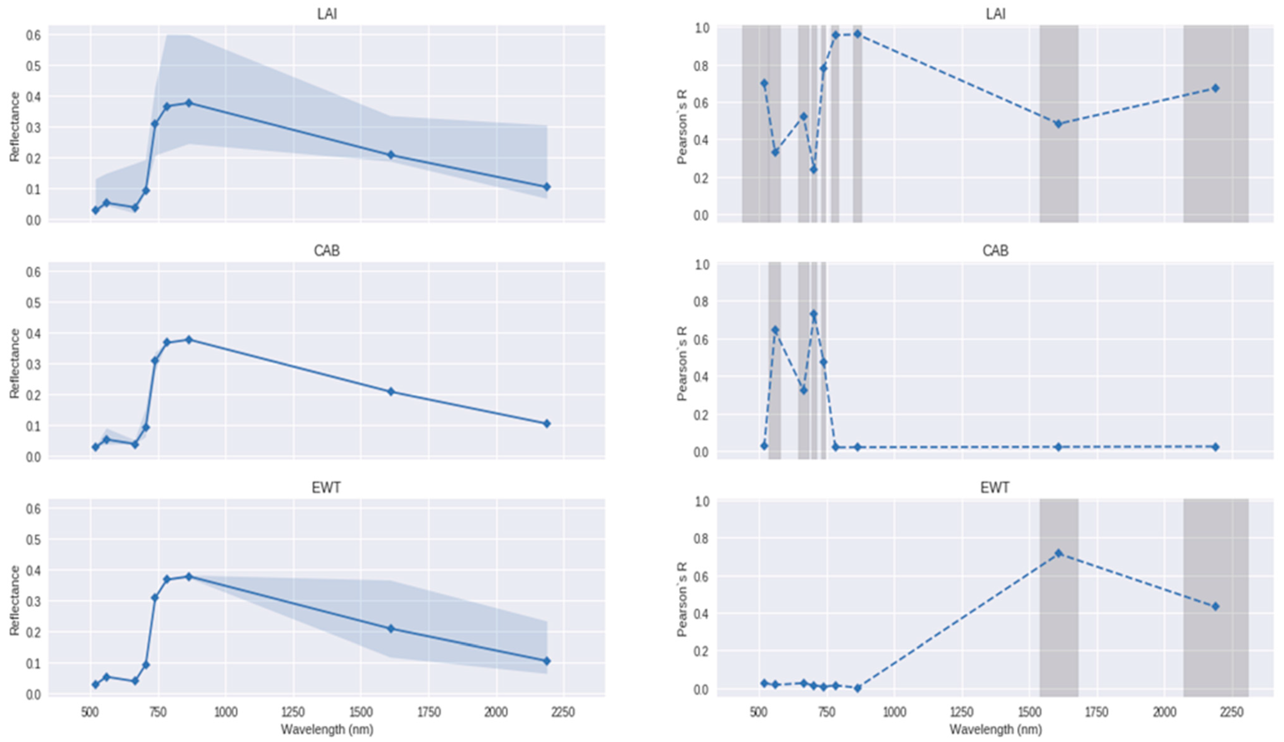
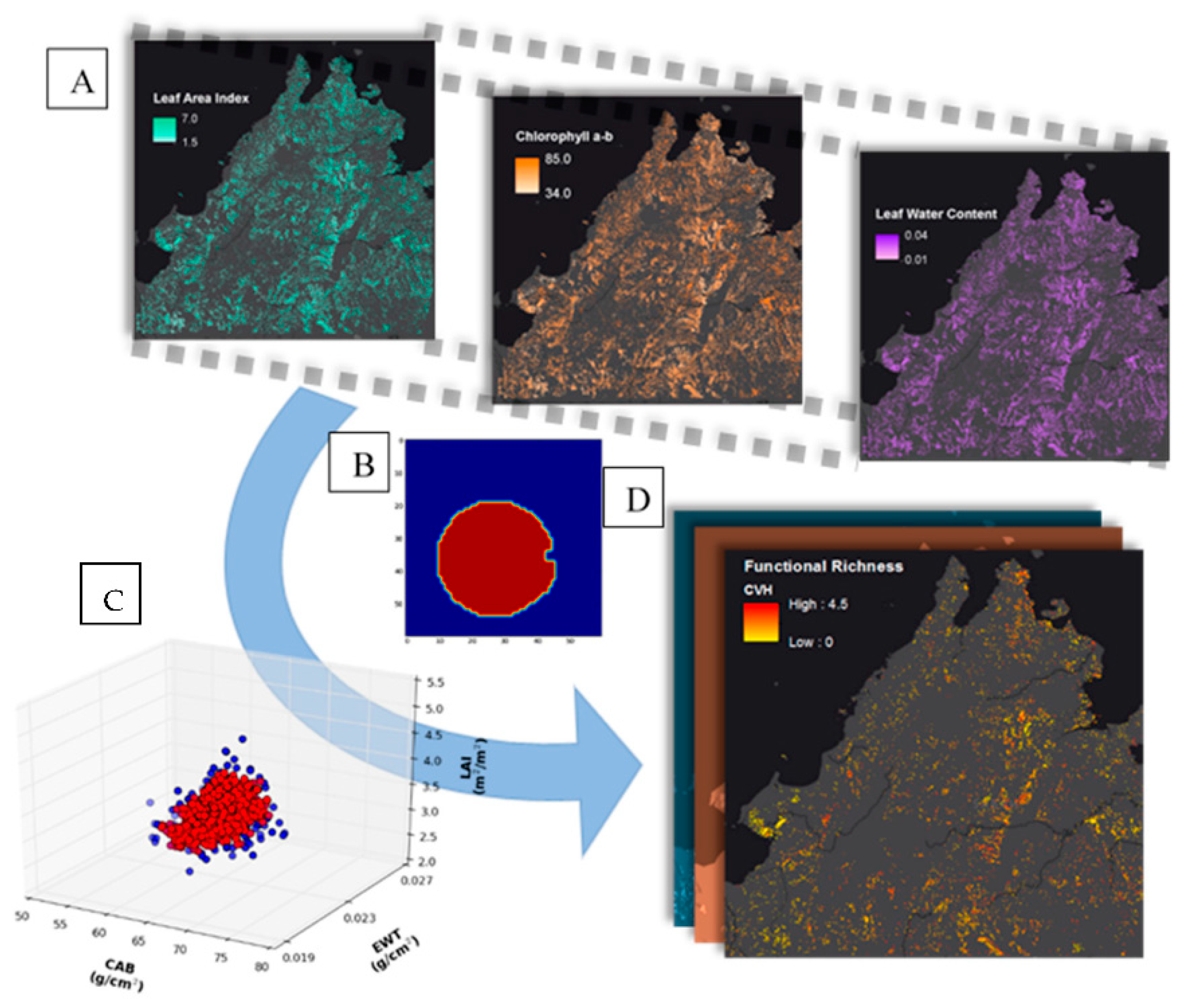
2.2. Retrieval of Functional Traits

Sentinel-2 L1c data were acquired through ESA’s Copernicus Scientific Hub over the extent of our study area. The Multi-Spectral Imager (MSI) offers observations over 13 spectral bands, the majority of which are at a 20 m spatial resolution [55]. Optical remote sensing acquisition above Sabah, Malaysia, is challenged by its year-round high average cloud cover. For this study, we acquired the Sentinel-2 observations for the 9th of July 2017 covering the study area (Figure A1a). The cloud cover on this date was one of the lowest since the launch of Sentinel-2 in 2014. Mosaicking multi-temporal images together would have introduced temporal deviances that could lead to diverse artifacts based on the inference date rather than vegetation characteristics. After the acquisition, the data were atmospherically corrected using the Sen2Cor processor [56,57]. Stringent quality flags stemming from both the atmospheric correction and the biophysical processor (see below) were applied to mask all areas affected by cloud contamination, poor atmospheric correction, poor trait retrievals (outside the physical range of variation), and shadows [57,58]. Additional cautionary buffers 100 m in radius were applied around the quality flags to further limit the influence of clouds and cloud shadows on the spectral properties of the imagery. Non-vegetated areas with a fractional cover (FC) below 30% were masked out to remove non-/marginally vegetated areas.
Estimation of canopy traits from the Sentinel-2 imagery was conducted using the biophysical processor of the ESA’s Sentinel Application Platform (SNAP) Sentinel-2 toolbox [58]. SNAP uses an artificial neural network (ANN) inversion that was pre-trained on a PROSAIL simulated database that included canopy reflectance and the corresponding set of input parameters. SNAP includes an unreleased version of PROSPECT prior to PROSPECT-4 [59], coupled with the SAIL model [60,61]. The value, range, and distribution followed for each input parameter of the models are described in [58] and aim to provide general global applicability without the ingestion of ecosystem-specific ancillary data, although that comes at the cost of precision [58]. PROSAIL is bound by strong simplification of canopies that assumes a homogenous turbid medium where absorption is defined by leaf, canopy, soil, and angular properties [62]. Therefore, the interpretation needs to be done in consideration of the underlying assumptions and application of a 1D model [63]. Despite its limitations, earlier validation studies reported reasonable performance of SNAP retrievals in forested regions [39,42] and are further addressed in the discussion section.
Traits in SNAP are derived at the canopy level and include leaf area index (LAI), canopy chlorophyll (CAB*LAI), and canopy water (EWT*LAI). We reversed the multiplication by LAI to arrive at leaf level estimates: leaf chlorophyll (CAB) and leaf equivalent water thickness (EWT). LAI specifies the leaf surface area per unit ground surface area. The retrieval conducted here produces a measure of the ‘effective LAI,’ which does not account for clumping factors and therefore differs from a ‘true LAI’ measure [64,65]. LAI (m2/m2) determines how much light can be captured to influence primary production, but also transpiration and energy exchange [65,66,67]. Complementary to LAI, CAB and EWT influence processes occurring at the leaf level [68]. CAB (µg/cm2) corresponds to a surface-based leaf content of chlorophyll-a and -b. Chlorophyll has an important role in determining the photosynthetic capacity and resource strategy of plants [69,70]. EWT (in g/cm2) refers to the water mass stored in leaves per leaf surface area. EWT is important for the physiological plant performance and regulatory mechanisms that play a role in drought and stress tolerance [71,72,73,74,75,76]. Taken together, the traits retrievable through SNAP are ecologically meaningful.

2.3. Estimating Functional Diversity

The spatially continuous retrieved traits from the Sentinel-2 spectral reflectance were used to further estimate the functional diversity. Functional diversity is commonly partitioned into three complementary aspects of functional diversity: richness, evenness, and divergence [50,77,78]. Functional richness is a measure of the functional space occupied by a community and was calculated based on the convex hull volume [79]. Functional divergence and evenness metrics describe how trait combinations are distributed within the community’s trait space, which are indicative of niche differentiation and niche space optimization, respectively [77,80,81,82]. Functional divergence was calculated with Euclidian distances applied to a centroid-based approach [50] that was adapted by Schneider et al. [83] for a pixel-based approach. Functional evenness was determined through branch length variation of the minimum spanning tree of a trait distance matrix signaling the regularity of the distribution across the trait space [50]. The functional diversity metrics were calculated over the 95% centermost data points, as determined by kernel density estimates, to limit the influence of extreme values, noise, and possible retrieval artifacts.
We opted for large plots, sized equally at 40 ha. (1000-pixel observations), to calculate the functional diversity metrics. This allowed for showcasing the capability of satellite remote sensing to map large spatially continuous plots to capture a large share of the variability in canopy compositions to base the functional diversity calculations on. With 1000-pixel observations, this design potentially harnesses robustness against noise in the observations. Despite the patchiness of the data due to the masks applied and the mosaic of land-use patterns, the 40 ha plots still offered a large number of data plots per land-use type (N = 5626). The plots were drawn using an algorithm based on minimal Euclidian distances to the starting pixel of the plot while solving the condition of meeting a single land-use continuous area of 40 ha [84].

2.4. Land-Use Data

Land use was derived from CIFOR’s open-access and validated ‘Atlas of deforestation and industrial plantations in Borneo’ (https://www.cifor.org/map/atlas/ accessed on 3 July 2018) [7,9]. Their validated maps are based on longitudinal, up to 30 m spatial resolution, LandSat satellite imagery (1973–2016) with additional visual, expert-based interpretation methods and maps of oil palm and pulpwood concessions. Here, we assessed the three largest vegetated land-use types: (1) ‘Intact Forest’, which are old-growth forests. The overstory of these forest ecosystems is generally characterized by old closed-canopy emergent trees. Dipterocarpaceae are the dominant tree species in primary forests, accounting for 25% of the tree population and 60% of the standing volume [85]. (2) ‘Logged Forest’, which are intact forests that have been impacted by industrial-scale mechanized selective logging at some point since 1973. (3) ‘Industrial Oil Palm Plantations’, which are production systems mainly revolving around monoculture planting of Elaeis guineensis jacq. Small-holder oil palm cannot be consistently distinguished in the land-use maps. An overview of the spatial distribution of these three dominant land-use types can be found in Figure A1b. Oil palm plantations were found to only occur in the lowlands (<500 m ASL) (Table A1). The Shuttle Radar Topography Mission (30 m spatial resolution) was used to map elevation. Elevation may affect differences in functional diversity within and between land-use types.

2.5. Data Analysis

To assess the plausibility of the trait values on which we based functional diversity estimates, the performance of the inversion of SNAP’s biophysical processor retrieval from spectra to traits was examined. First, we conducted a sensitivity analysis to assess the spectral layout of Sentinel-2 bands in terms of receptiveness to retrieve these traits. The analysis was based on repeated PROSAIL simulations with random variations of the trait values while mapping the spectral responses and the correlation between Sentinel-2’s spectral bands and trait variations.
Second, we re-modeled the spectra based on PROSAIL in forward mode from the estimated trait values. The simulated spectra were compared against the observed Sentinel-2 spectra to assess the performance across different land-use types. This was done for 20,000 randomly drawn pixels over the study area. The search ranges for the remaining PROSAIL traits were constrained to the distribution of input variables described by [58]. We used spectral angle mapper (SAM), mean absolute error (MAE), and root mean squared error (RMSE) to assess the deviation between the simulated and actual spectra. We evaluated differences in errors across land-use types to examine whether differential performance across land-use types could have affected our results.
Third, we compared retrieved trait distributions against in situ measured traits of common species in the different studied land-use types [64,86,87,88]. For LAI, the study by Hadi et al. [64] provided measurements of effective LAI across sampling sites in Sabah consisting of unlogged forest, logged forest, and oil palm plantations, although the plantations sampled were relatively young (planted <10 years ago). The CABs of forests and oil palm plantations were available for top-of-canopy chlorophyll for adult oil palms (Elaeis guineensis) from [88] and those of intact forests in Danum Valley were from [86]. Relevant field measurements on EWT relevant to our study area were difficult to acquire. However, we were able to model EWT based on data on LMA available from the ‘Traits of Bornean Trees Database’ [89], which is part of the global TRY plant trait database [90]. For the ‘Traits of Bornean Trees Database’, we focussed on Dipterocarpaceae specifically, considering their dominant role in the primary forest in Sabah, accounting for 25% of the tree population and 60% of the standing volume [85]. To model EWT, we assumed a leaf water content of 63% following findings by [91] for tropical evergreen forests. We simulated the range of EWT values based on these data through the following equation:
E W T = ( L W C % 1 L W C % ) ( L M A )
Differences in functional diversity metrics between land-use types were assessed using ANOVAs. The assumptions of the ANOVAs were evaluated and a log transformation of functional richness was conducted to ensure the normality of residuals in an otherwise strongly skewed distribution. The explained variance was expressed through eta2 values which is a measure of effect size for use in ANOVA, analogous to R2 in multiple linear regression. Significant differences between individual land-use types were further analyzed using a post hoc Tukey’s HSD test.

3. Results

3.1. From Mapping Spatially Explicit Spectral Trait Indicators to Functional Diversity Estimates

The trait maps presented a high degree of patchiness due to the applied masks (including clouds, quality flags, vegetation cover, and land use) (Figure 1a). The plausibility of the spectral trait indicators was assessed through three analyses to test their validity. First, the sensitivity analysis of Sentinel-2’s bands to the spectral trait indicators (LAI, CAB, and EWT) retrieved in this study showed promising responsiveness (Figure A2). Second, the reversely estimated spectra modeled using PROSAIL—simulated from the SNAP-retrieved trait estimates as input—had an RMSE of 0.012, which was a 7.6 percent mean deviation from the actually observed spectra. No profound differences in errors were observed between the individual land-use types, which suggested there was no structural bias in the inversion performance for approximation of the vegetation present in different land uses (Table A2). Finally, the comparison of the retrieved trait values to those presented in trait databases and the literature suggested that the estimated ranges of the retrieved traits were to a large degree in line with the ranges of trait values previously measured in Borneo (Figure A3).

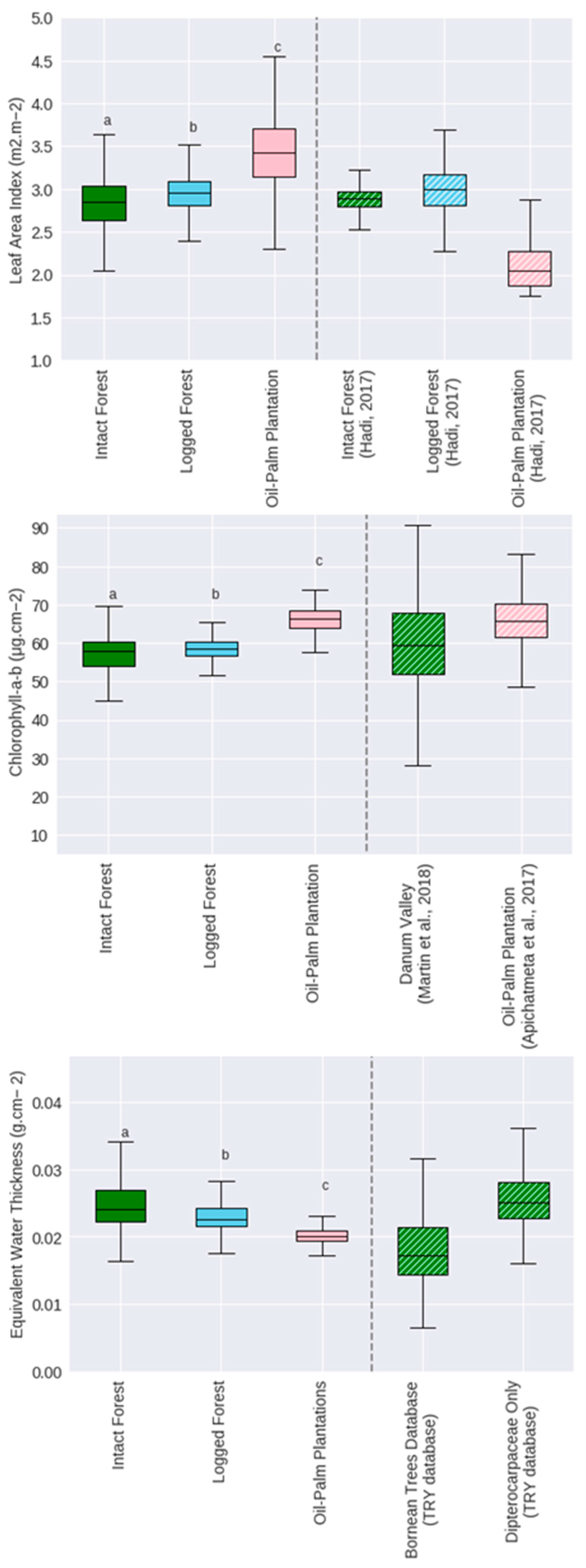
3.2. Land-Use Patterns of Plant Functional Diversity

The spatially continuous maps of functional diversity estimates were exemplified by functional richness in Figure 1d. All functional diversity metrics appeared to differ significantly across land-use types, with all p-values well below 0.001 (Figure 2). The post hoc analysis revealed that logged forest and intact forest were statistically similar in terms of functional richness and functional evenness. For all functional diversity metrics, intact and logged forests were significantly different from oil palm plantations (Figure 2).

4. Discussion

Our case study in Sabah is illustrative of a biodiversity hotspot at risk of commodity-driven land-use changes [3,8,9]. The impact of land use on functional biodiversity has been widely studied in ecology, generally through small-scale local field studies [21,22]. We have re-projected these ecological expectations to scale up considerably from traditional field assessments to the potential to study large-scale landscapes, whole regions, and terrestrial ecosystems instantaneously and with spatial continuity. Despite still being an early adoption, the results indicate initial correspondence of satellite remote-sensing-derived functional diversity metrics to broad human disturbance gradients shaped by land use. These insights may be further developed when in situ validation data and relevant ancillary ecosystem-specific information would become available. In this discussion, we address the current workflow and results in light of the limitations of the methodology applied and the value of qualitative assessments against historic trait measurements and land-use gradients.

4.1. Trait Retrieval for Functional Diversity

This study applied a workflow (Figure 1) to map the functional diversity using Sentinel-2 over a large continuous region without a heavy reliance on a priori in situ canopy trait measurements. The latter is relevant as matched field samples are hard to obtain across large geographic extents and pixel-based scales. The validity of such large-scale functional diversity estimates depends on the accuracy and representation of traits. Trait selection is constrained by the specifications of the sensor and the parameters of the radiative transfer models applied. Here, the selected traits were related to relevant carbon and water fluxes and offered three axes of functional differentiation [65,69,76,92]. The current selection of traits was pragmatic, where a larger number of traits might increase the ability to detect functional differences between observations [24]. In practice, however, model inversion becomes increasingly challenged by ill-posedness with a larger number of traits to be retrieved with the same amount of input data, especially in multi-spectral broadband inference.
For the current trait selection (LAI, CAB, and EWT), the sensitivity analysis of the Sentinel-2’s bands showed promising responsiveness (Figure A2). This analysis served as a precursor of the performance of PROSAIL within SNAP when applied to Sentinel-2. Due to its ease of use, genericity, and, most importantly, functionality without hard-to-obtain ancillary data, the SNAP biophysical processor is currently a likely first port of call for many users [39], although it clearly also has limitations.
The ANN in SNAP is meant to provide generic global applicability without the ingestion of ecosystem-specific ancillary data [58]. However, it was shown that local optimization of the trait ranges under study for inversion can improve retrieval performance [42,93,94,95]. SNAP’s biophysical processor does not facilitate a re-training of the ANN on PROSAIL simulations specific to the ecosystems studied here. Such functionality could theoretically improve the accuracy of spectral trait indicators. Additionally, the implementation of active learning heuristics can prove helpful regarding adding constraints to inversion space and facilitating intelligent sampling for the training of retrieval algorithms to overcome some of the ill-posedness and optimize a simulation subset to the ecosystem under study [40,96,97].
Similarly, it may be argued that there are radiative transfer models that are better suited for heterogeneous forest canopies as compared to PROSAIL, which is bound by 1D simplification of canopies [98]. However, alternative radiative transfer models, e.g., INFORM [99] and FRT [100], are complex and require a larger number of biophysical parameters. Without a priori information, the heavy parameterization in inversion may further induce ill-posedness and therefore, in fact, hamper retrieval performance and feasibility, especially in multi-spectral settings [39,101].
Despite its limitations, the suitability of SNAP for agricultural applications was confirmed in several studies [102,103,104,105,106]. For forests, Brown et al. [39], Hauser et al. [42], and Nguyen et al. [97] reported reasonable performances of the SNAP retrieval algorithm in a deciduous broadleaf forest site in Southern England, a heterogenous shrub-forest landscape in Portugal, and mangrove forests, respectively. Moreover, the performance of SNAP in a heterogeneous mixed mountain forest in Bavaria, Germany was similar to that of the input parameter heavy INFORM inversion [37]. While none of these studies applied SNAP in rainforest ecosystems relevant to our study area, these quantitative findings suggested that our pipeline is reasonable for indicative large-scale applications.
Consistent with that assessment is our finding that there was no indication of structural biases in inversion between the land-use types (Table A2) or deviation from regionally relevant trait ranges presented in literature and the TRY database (Figure A3). The most notable deviance against historic trait measurements is an overestimation of the observed LAI of oil palm plantations compared to Hadi et al.’s [64] effective LAI measurements. Differences in LAI between young plantations versus older plantations might have been responsible for this discrepancy. In our study, observed LAI values were the highest in plantations rather than tropical evergreen broadleaf forests (Figure A3). This was also reported by [65]. Intensive management regimes—through planting schemes, fertilizer, and pest management—aim to maximize production in these plantations and both resonate with relatively high chlorophyll and LAI ranges. Industrial oil palm plantations are often located on more favorable lands for high productivity in terms of elevation and slope (Table A1).
Nonetheless, the comparison against historic trait measurements should be considered carefully. First, there are temporal mismatches between the data of Sentinel-2 acquisition and the in situ trait measurements used for comparison. This likely results in inconsistencies in the comparisons made, especially given the cyclical nature and phenology of ecosystem processes [33,107]. Second, the used historic trait data were sampled at the level of individual canopies/branches/leaves, whereas the Sentinel-2 inference results in an aggregation of multiple canopies in pixels scaled in a 20 m resolution raster [47]. Indeed, the field-based estimates of EWT and CAB of individuals exhibited a larger variation as compared to satellite-observed trait indicators (Figure A3). The pixel-based aggregation of multiple species of the latter might have leveled out some of the individual variations found in the former. Third, the aggregation of canopies in Sentinel-2 pixels resulted in a dominant signal of the overstory vegetation and, in particular, the top of the canopy. Accurate correspondence of field measurements to top-of-the-canopy sunlit overstory samples is not necessarily warranted in trait databases [108]. Lastly, in contrast to species-mean trait estimates, the large-scale continuous inference through remote sensing will likely include the local representation of intra-specific variation [33].

4.2. Land-Use Gradient as Qualitative Assessment

The scale and extent of satellite remote sensing in comparison to common field observations seriously challenges quantitative validation efforts for plant diversity assessments. In light of the scarcity of relevant ground measurements, this study aimed to exploit the spatial continuity and synoptic inference of satellite remote sensing observations via qualitative testing against well-studied and large-scale ecological gradients. Airborne studies, e.g., [48,49,109], examined remotely sensed trait diversity against hypothesized linkages between functional diversity and ecosystem productivity, spatial scales, elevation, and climatic gradients. Here, we have scaled up to Sentinel-2 to compare functional diversity against different land-use types given that land use is known to strongly impact functional diversity [22,110]. The ability of satellite-derived functional diversity metrics to detect such differences at regional spatial extents offers an initial evaluation of its potential to study broad ecological phenomena from space.
The results indicated significant differences between land-use classes across functional diversity metrics. Although different spatial scales and even taxa present a challenge for quantitative comparisons, our findings corresponded qualitatively with conclusions from field studies using ground measurements; intact forests and logged forests harbor significantly more functional diversity than oil palm plantations [15,16,111,112]. The significance of differences in functional diversity did vary strongly across the metrics applied. Land use explained approximately 9% of the variance in functional richness (Figure 2). Functional divergence and evenness patterns differed more strongly across the land-use gradient, explaining 57% and 17% of the observed variance, respectively.
The low explained variance for functional richness corresponded with its high variation within the different land-use types (Table 1, Figure 2). Part of this variation could be related to a variation in landscape properties over the large geographic extent. The variation in terms of soil, elevation, slope, landscape heterogeneity (geodiversity), and microclimates may all affect functional richness [113,114]. Additional analysis (Figure A4) indeed confirmed a strong decrease in functional richness with increasing elevation for the different land-use types. By reducing the spatial extent of analysis to a smaller subset within the study area, the explanatory power of land-use types increased substantially. The findings from the subset revealed a significant increase in the explained variance of land use for functional richness (~15%) while still signaling a large variance within land-use classes. Importantly, the convex hull volume—on which the calculation of functional richness is based—is relatively sensitive to anomalous observations [115]. Our analysis was somewhat conservative by looking only at the 95% centermost observations through kernel density estimates. Nevertheless, the large landscape heterogeneity combined with noise and inconsistencies in the surface reflectance and spectral trait indicator retrieval can introduce variations that strongly affect overall functional richness.
Despite large within-group variation in functional richness, the distinction between forested and oil palm plantation land-use types remained significant and prevailed across a large spatial extent and number of plots. The highest mean functional richness was found in intact forests, closely followed by logged forests. Previous studies pointed out that functional richness can peak in sites that are exposed to moderate disturbances, creating heterogeneity in ontogenetic stages and landscape characteristics, which could play a role in the comparable functional richness between intact and logged forests [24,116,117].
Functional divergence showed more profound differences across land-use types. Intact forest recorded the highest levels of functional divergence in our analysis, followed by logged forests and oil palm plantations. The interpretation of functional divergence is tied to niche differentiation within ecological communities [77,80,81,82]. Niche differentiation contributes to the maintenance of functional diversity in natural tropical systems [82]. More intensively managed land-use regimes, which are characterized by monoculture, planting schemes, and pest management, diminish natural processes that allow for niche differentiation [118,119,120]. This resonates with the main differences found in our results, with oil palm plantations scoring significantly lower on functional divergence (Figure 2).
Functional evenness relates to how evenly trait space is filled [50,78,80]. Even distributions can be tied to a degree of optimization of trait space in response to resource availability, as well as to less functional redundancy. In man-made landscapes, such drivers are suppressed by monoculture planting, pest management, and homogenous ontogenetic stages/tree sizes. Oil palm plantations exhibited significantly lower divergence and evenness within the trait space observed (Figure 2). Both functional divergence and evenness were relatively unchanged across elevations (Figure A4). This coincided with findings by [49] in tropical forests across an Amazon-to-Andes elevation gradient.

4.3. Outlook

Beyond the shortcomings, the study provides a new platform and geographic extent (spatial scale) that indicated that oil palm plantations exhibited significantly lower functional diversity than intact or logged forests, which can contribute to the debate on oil palm’s impact on tropical biodiversity and further build a case against controversial proposals to reclassify oil palm as a forest cover type [12,121,122]. Our exploration builds a case for further investment in quantitative validation through dedicated field campaigns. From this point, investing in and overcoming the challenges of representative in situ validation of pixel-based functional diversity is the next stride to further assess its accuracy and more subtle differences, as well as the robustness of these metrics against uncertainties in trait estimates. Moreover, in terms of retrieval, further maturation of the current approach toward full spatio-temporal continuity will be needed. This will include multi-temporal observations; data assimilation of multi-sensor, multi-scale remote sensing observations; and ancillary ecological datasets to achieve the following: (i) study change in functional diversity over time (important to study the impact of human disturbances; [18,123]); (ii) include a wider range of consistent traits and deal with the ill-posedness of such retrieval; (iii) allow for cross-validation with spatial, temporal, and spectral consistency across instruments; (iv) study the effects of scale and grain; and (v) overcome data gaps caused by clouds (highly relevant for humid tropical rainforests such as those found in Sabah) and other interferences [124,125,126,127].

5. Conclusions

By linking the functional diversity estimates derived from remote sensing to land-use information, this study showed the potential merits to study broad ecological patterns over large geographical extents using satellite earth observation. The study provides a new platform and geographic extent (spatial scale) that strongly indicated that oil palm plantations exhibited significantly lower functional diversity as compared to intact and logged forests, coinciding with results from earlier field studies. Specifically, we found that the observed differences in functional diversity across the land-use gradient were significant. Notably, profound differences between metrics were observed: a large variance within land-use types was observed for functional richness, while functional divergence exhibited particularly strong responsiveness to land use. With that in mind, this study acts as an exemplar for satellite-derived monitoring of functional diversity for a key biodiversity area for which traditionally little information is available. The study provides an early application toward the maturation of a spatially and temporally explicit method that hopefully fuels further validation efforts and assessment of its responsiveness across ecological gradients.

Author Contributions

Conceptualization, L.T.H., J.T., N.A.S. and P.M.v.B.; Formal analysis, L.T.H.; Funding acquisition, P.M.v.B.; Methodology, L.T.H.; Supervision, J.T., N.A.S. and P.M.v.B.; Visualization, L.T.H.; Writing—original draft, L.T.H.; Writing—review & editing, L.T.H., J.T., N.A.S. and P.M.v.B. All authors have read and agreed to the published version of the manuscript.

Funding

This project has received funding from the European Union’s Horizon 2020 research and innovation program through the MULTIPLY project (http://www.multiply-h2020.eu/) under grant agreement no. 687320.

Conflicts of Interest

The authors declare no conflict of interest.

Appendix A

Figure A1. (A) Map of the Sentinel-2 observation, as seen through a true visible range composite image, over the study area in Sabah, Malaysia, on the 9th of July 2017 after atmospheric corrections. (B) Map of the three land-use classes within the Sabah study area used for analysis.
Land 11 00572 g0a1
Table A1. Descriptive statistics of elevation and slope observed between plots across land-use types. Data is derived from digital elevation models observed by the 30 m spatial resolution Shuttle Radar Topography Mission (SRTM).
Land UseNMean Elevation (m)Mean Slope (% Change)
Land 11 00572 i001Intact Forest1192439.901.88
Land 11 00572 i002Logged Forest3018419.711.30
Land 11 00572 i003Oil Palm Plantations141663.840.74

Appendix A.1. Qualitative Assessment of the Validity of Spectral Trait Indicators

To assess the plausibility of the derived spectral trait indicators on which we based functional diversity estimates, the performance of the inversion of SNAP’s biophysical processor retrieval from spectra to traits was examined.
First, we conducted a sensitivity analysis to assess the spectral layout of the Sentinel-2 bands in terms of receptiveness to retrieve these traits (Figure A2). The analysis was based on repeated PROSAIL simulations with random variations of the trait values while mapping the spectral responses and the correlation between Sentinel-2’s spectral bands and trait variation. The findings demonstrated significant spectral sensitivity to the studied traits (LAI, EWT, and CAB) (Figure A2). These findings matched the sensitivity analyses of Sentinel-2 for retrieval of the traits under study (LAI, CAB, and EWT) that were demonstrated in previous sensitivity analyses [43,128,129,130].
Figure A2. Sensitivity analysis of PROSAIL’s LAI, CAB, and EWT parameters to the spectral layout of Sentinel-2 MSI bands used in this study. The left pane illustrates the range of variability in spectral response to changes in the parameters, while all other parameters were kept constant in the modes defined in [58]. The right pane depicts the correlation (Pearson’s R) of different bands to changes in the parameters using a range of simulations defined in [58]. Significant correlations are indicated by the grey highlighted bars.
Land 11 00572 g0a2
Second, the presence of biases in the derived spectral trait indicators across land-use types was examined by reversing the inversion process. From the spectrally retrieved trait estimates obtained through inversion, we re-modeled the spectra based on PROSAIL in forward mode. The simulated spectra were compared against the actual observed Sentinel-2 spectra to assess the performance (size of the error) between different land-use types/canopy types. This was done for 20,000 randomly drawn pixels over the study area. Search ranges for the remaining PROSAIL traits were constrained to the distribution of input variables described by [58]. We used spectral angle mapper (SAM), mean absolute error (MAE), and root mean squared error (RMSE) to assess the deviation between the simulated and actual spectra. We evaluated differences in the size of errors across land-use types to examine whether such biases could have affected our results. On average, across the land-use types, an RMSE of 0.012 was observed, which was a 7.6 percent mean deviation from the actually observed spectra (Table A2). No profound differences in errors were observed between the individual land-use types, which suggested that there was no structural bias in the inversion performance for approximation of the vegetation present in different land uses.
Table A2. Comparison of errors between simulated spectra with retrieved trait estimates as input and actual Sentinel-2 reflectance spectra stratified across land-use types.
RMSE MAE %nRMSESampled Pixels (N)
Land Useµσµσµ
Intact Forest0.0120.0090.0070.0057.64774
Logged Forest0.0140.010.0080.0068.94274
Oil Palm Plantations0.0120.010.0070.0067.23952
Third, we compared the distributions of spectral trait indicators against in situ measured traits of common species in the different studied land-use types. Figure A3 indicates that the spectral trait indicators were to a large degree in line with the range of measurements from field studies. The most notable deviances were as follows: (1) An overestimation of LAI in oil palm plantations compared to Hadi et al.’s [130] effective LAI measurements. Hadi et al.’s [130] measurements are conducted in relatively recently planted oil palm plantations. Differences in LAI between young plantations versus older plantations might be responsible for this discrepancy. (2) A much larger variation of EWT and CAB in the species measurement conducted in the field. Notably, these measurements consisted of a variety of individual species, whereas our observations were based on the pixel-based aggregation of multiple species, possibly leveling out some of the variations.
Figure A3. Comparison of the retrieval of spectral trait indicators from SNAP’s biophysical processor derived from Sentinel-2 reflectance spectra to relevant in situ trait ranges in the TRY plant trait database [89,90] and other regionally relevant field campaigns [64,86,88,131]. Differences in retrieved trait estimates between land-use types according to a post hoc Tukey’s HSD test are indicated with different annotated letters (a, b, c).
Land 11 00572 g0a3

Appendix A.2. Functional Diversity across Elevations

Figure A4. Variation of functional diversity metrics along the average elevation of the plot. Green represents intact forests and blue indicates logged forests. Oil palm plantations were only found below 500 m ASL.
Land 11 00572 g0a4
Functional richness decreased along the elevational gradient. In line with ecological theory, this indicates a stronger functional convergence with elevation linked to stronger environmental filtering of fitness in higher altitudes [49]. A steep drop in functional richness was particularly observable above 1400 m ASL. These findings corresponded with earlier studies on elevational patterns of tree species richness on Mount Kinabalu, Borneo [51,52,53]. Similar to the functional richness in our study, tree species were found to decrease rapidly with elevation above 1500 m [53]. Moreover, using airborne remote sensing, studies showed a lower functional richness at a higher elevation, suggesting a smaller range of resource availability at higher altitudes, whereas, again, functional divergence remained relatively unaffected by elevation [49].
Generally, we observed a negative correlation between functional richness and elevation of Pearson’s R = −0.18 for both land-use types and Pearson’s R = −0.31 for intact forests specifically. For logged forests, we observed an initial increase in functional richness before following a similar decrease as seen in intact forests. Functional divergence and functional evenness, on the other hand, indicated little variation with elevation. Oil palm plantations were not found to be grown at elevations above 500 m above sea level (Table A1). Therefore, this did not allow for studying elevational effects in oil palm plantations.

References

  1. IPBES. Global Assessment Report on Biodiversity and Ecosystem Services of the Intergovernmental Science—Policy Platform on Biodiversity and Ecosystem Services; IPBES Secretariat: Bonn, Germany, 2019. [Google Scholar]
  2. Newbold, T.; Hudson, L.N.; Arnell, A.P.; Contu, S.; De Palma, A.; Ferrier, S.; Hill, S.L.L.; Hoskins, A.J.; Lysenko, I.; Phillips, H.R.P.; et al. Has land use pushed terrestrial biodiversity beyond the planetary boundary? A global assessment. Science 2016, 353, 288–291. [Google Scholar] [CrossRef]
  3. UNDP. Biodiversity Conservation in Multiple-Use Forest Landscapes in Sabah, Malaysia; UNDP: Sabah, Malaysia, 2012. [Google Scholar]
  4. Wilcove, D.S.; Giam, X.; Edwards, D.P.; Fisher, B.; Koh, L.P. Navjot’s nightmare revisited: Logging, agriculture, and biodiversity in Southeast Asia. Trends Ecol. Evol. 2013, 28, 531–540. [Google Scholar] [CrossRef]
  5. Sodhi, N.S.; Koh, L.P.; Brook, B.W.; Ng, P.K.L. Southeast Asian biodiversity: An impending disaster. Trends Ecol. Evol. 2004, 19, 654–660. [Google Scholar] [CrossRef]
  6. Sodhi, N.S.; Koh, L.P.; Clements, R.; Wanger, T.C.; Hill, J.K.; Hamer, K.C.; Clough, Y.; Tscharntke, T.; Posa, M.R.C.; Lee, T.M. Conserving Southeast Asian forest biodiversity in human-modified landscapes. Biol. Conserv. 2010, 143, 2375–2384. [Google Scholar] [CrossRef]
  7. Gaveau, D.L.A.; Sloan, S.; Molidena, E.; Yaen, H.; Sheil, D.; Abram, N.K.; Ancrenaz, M.; Nasi, R.; Quinones, M.; Wielaard, N.; et al. Four decades of forest persistence, clearance and logging on Borneo. PLoS ONE 2014, 9, e101654. [Google Scholar] [CrossRef] [Green Version]
  8. Bryan, J.E.; Shearman, P.L.; Asner, G.P.; Knapp, D.E.; Aoro, G.; Lokes, B. Extreme Differences in Forest Degradation in Borneo: Comparing Practices in Sarawak, Sabah, and Brunei. PLoS ONE 2013, 8, e69679. [Google Scholar] [CrossRef] [Green Version]
  9. Gaveau, D.L.A.; Sheil, D.; Salim, M.A.; Arjasakusuma, S.; Ancrenaz, M.; Pacheco, P.; Meijaard, E. Rapid conversions and avoided deforestation: Examining four decades of industrial plantation expansion in Borneo. Sci. Rep. 2016, 6, 32017. [Google Scholar] [CrossRef]
  10. Maycock, C.R.; Kettle, C.J.; Khoo, E.; Pereira, J.T.; Sugau, J.B.; Nilus, R.; Ong, R.C.; Amaludin, N.A.; Newman, M.F.; Burslem, D.F.R.P. A Revised Conservation Assessment of Dipterocarps in Sabah. Biotropica 2012, 44, 649–657. [Google Scholar] [CrossRef] [Green Version]
  11. Fitzherbert, E.B.; Struebig, M.J.; Morel, A.; Danielsen, F.; Brühl, C.A.; Donald, P.F.; Phalan, B. How will oil palm expansion affect biodiversity? Trends Ecol. Evol. 2008, 23, 538–545. [Google Scholar] [CrossRef]
  12. Koh, L.P.; Wilcove, D.S. Is oil palm agriculture really destroying tropical biodiversity? Conserv. Lett. 2008, 1, 60–64. [Google Scholar] [CrossRef]
  13. Bernard, H.; Fjeldså, J.; Mohamed, M. A case study on the effects of disturbance and conversion of tropical lowland rain forest on the non-volant small mammals in north Borneo: Management implications. Mammal Study 2009, 34, 85–96. [Google Scholar] [CrossRef]
  14. Benedick, S.; Hill, J.K.; Mustaffa, N.; Chey, V.K.; Maryati, M.; Searle, J.B.; Schilthuizen, M.; Hamer, K.C. Impacts of rain forest fragmentation on butterflies in northern Borneo: Species richness, turnover and the value of small fragments. J. Appl. Ecol. 2006, 43, 967–977. [Google Scholar] [CrossRef]
  15. Barnes, A.D.; Jochum, M.; Mumme, S.; Haneda, N.F.; Farajallah, A.; Widarto, T.H.; Brose, U. Consequences of tropical land use for multitrophic biodiversity and ecosystem functioning. Nat. Commun. 2014, 5, 6351. [Google Scholar] [CrossRef]
  16. Edwards, F.a.; Edwards, D.P.; Larsen, T.H.; Hsu, W.W.; Benedick, S.; Chung, a.; Vun Khen, C.; Wilcove, D.S.; Hamer, K.C. Does logging and forest conversion to oil palm agriculture alter functional diversity in a biodiversity hotspot? Anim. Conserv. 2014, 17, 163–173. [Google Scholar] [CrossRef]
  17. Neo, L.; Tan, H.T.W.; Wong, K.M. Too little, too late? Conservation exigencies for Borneo inferred from biogeographic considerations of its endemic plant genera against intense landscape modifications. Biodivers. Conserv. 2021, 31, 59–76. [Google Scholar] [CrossRef]
  18. Jetz, W.; Cavender-Bares, J.; Pavlick, R.; Schimel, D.; Davis, F.W.; Asner, G.P.; Guralnick, R.; Kattge, J.; Latimer, A.M.; Moorcroft, P.; et al. Monitoring plant functional diversity from space. Nat. Plants 2016, 2, 16024. [Google Scholar] [CrossRef] [Green Version]
  19. Hortal, J.; De Bello, F.; Diniz-Filho, J.A.F.; Lewinsohn, T.M.; Lobo, J.M.; Ladle, R.J. Seven Shortfalls that Beset Large-Scale Knowledge of Biodiversity. Annu. Rev. Ecol. Evol. Syst. 2015, 46, 523–549. [Google Scholar] [CrossRef] [Green Version]
  20. Petchey, O.L.; Gaston, K.J. Functional diversity (FD), species richness and community composition. Ecol. Lett. 2002, 5, 402–411. [Google Scholar] [CrossRef]
  21. Flynn, D.F.B.; Gogol-Prokurat, M.; Nogeire, T.; Molinari, N.; Richers, B.T.; Lin, B.B.; Simpson, N.; Mayfield, M.M.; DeClerck, F. Loss of functional diversity under land use intensification across multiple taxa. Ecol. Lett. 2009, 12, 22–33. [Google Scholar] [CrossRef]
  22. de Souza, D.M.; Flynn, D.F.B.; DeClerck, F.; Rosenbaum, R.K.; de Melo Lisboa, H.; Koellner, T. Land use impacts on biodiversity in LCA: Proposal of characterization factors based on functional diversity. Int. J. Life Cycle Assess. 2013, 18, 1231–1242. [Google Scholar] [CrossRef]
  23. Diaz, S.; Cabido, M. Vive la difference: Plant functional diversity matters to ecosystem processes: Plant functional diversity matters to ecosystem processes. Trends Ecol. Evol. 2001, 16, 646–655. [Google Scholar] [CrossRef]
  24. Cadotte, M.W.; Carscadden, K.; Mirotchnick, N. Beyond species: Functional diversity and the maintenance of ecological processes and services. J. Appl. Ecol. 2011, 48, 1079–1087. [Google Scholar] [CrossRef]
  25. Fukami, T.; Bezemer, T.M.; Mortimer, S.R.; Van Der Putten, W.H. Species divergence and trait convergence in experimental plant community assembly. Ecol. Lett. 2005, 8, 1283–1290. [Google Scholar] [CrossRef]
  26. Violle, C.; Reich, P.B.; Pacala, S.W.; Enquist, B.J.; Kattge, J. The emergence and promise of functional biogeography. Proc. Natl. Acad. Sci. USA 2014, 111, 13690–13696. [Google Scholar] [CrossRef] [Green Version]
  27. Hooper, D.U. Species diversity, functional diversity and ecosystem functioning. In Biodiversity and Ecosystem Functioning: Synhesis and Perspectives; Oxford University Press on Demand: Oxford, UK, 2002. [Google Scholar]
  28. Asner, G.P.; Martin, R.E.; Anderson, C.B.; Knapp, D.E. Quantifying forest canopy traits: Imaging spectroscopy versus field survey. Remote Sens. Environ. 2015, 158, 15–27. [Google Scholar] [CrossRef]
  29. Götzenberger, L.; de Bello, F.; Bråthen, K.A.; Davison, J.; Dubuis, A.; Guisan, A.; Lepš, J.; Lindborg, R.; Moora, M.; Pärtel, M.; et al. Ecological assembly rules in plant communities-approaches, patterns and prospects. Biol. Rev. 2012, 87, 111–127. [Google Scholar] [CrossRef]
  30. Chiarucci, A.; Bacaro, G.; Scheiner, S.M. Old and new challenges in using species diversity for assessing biodiversity. Philos. Trans. R. Soc. B Biol. Sci. 2011, 366, 2426–2437. [Google Scholar] [CrossRef] [Green Version]
  31. Granger, V.; Bez, N.; Fromentin, J.; Meynard, C.; Jadaud, A.; Mérigot, B. Mapping diversity indices: Not a trivial issue. Methods Ecol. Evol. 2015, 6, 688–696. [Google Scholar] [CrossRef] [Green Version]
  32. Takashina, N.; Economo, E.P. Developing generalized sampling schemes with known error properties: The case of a moving observer. Ecography 2021, 44, 293–306. [Google Scholar] [CrossRef]
  33. Schimel, D.; Pavlick, R.; Fisher, J.B.; Asner, G.P.; Saatchi, S.; Townsend, P.; Miller, C.; Frankenberg, C.; Hibbard, K.; Cox, P. Observing terrestrial ecosystems and the carbon cycle from space. Glob. Chang. Biol. 2015, 21, 1762–1776. [Google Scholar] [CrossRef]
  34. Jensen, J.R. Remote Sensing of the Environment: Pearson New International Edition: An Earth Resource Perspective; Pearson Education Limited: London, UK, 2013; ISBN 9781292034935. [Google Scholar]
  35. Butler, D. Earth observation enters next phase. Nature 2014, 508, 160–161. [Google Scholar] [CrossRef] [Green Version]
  36. Serbin, S.P.; Wu, J.; Ely, K.S.; Kruger, E.L.; Townsend, P.A.; Meng, R.; Wolfe, B.T.; Chlus, A.; Wang, Z.; Rogers, A. From the Arctic to the tropics: Multibiome prediction of leaf mass per area using leaf reflectance. New Phytol. 2019, 224, 1557–1568. [Google Scholar] [CrossRef]
  37. Ali, A.M.; Darvishzadeh, R.; Skidmore, A.; Gara, T.W.; O’Connor, B.; Roeoesli, C.; Heurich, M.; Paganini, M. Comparing methods for mapping canopy chlorophyll content in a mixed mountain forest using Sentinel-2 data. Int. J. Appl. Earth Obs. Geoinf. 2020, 87, 102037. [Google Scholar] [CrossRef]
  38. Ali, A.M.; Darvishzadeh, R.; Skidmore, A.; Heurich, M.; Paganini, M.; Heiden, U.; Mücher, S. Evaluating prediction models for mapping canopy chlorophyll content across biomes. Remote Sens. 2020, 12, 1788. [Google Scholar] [CrossRef]
  39. Brown, L.A.; Ogutu, B.O.; Dash, J. Estimating Forest Leaf Area Index and Canopy Chlorophyll Content with Sentinel-2: An Evaluation of Two Hybrid Retrieval Algorithms. Remote Sens. 2019, 11, 1752. [Google Scholar] [CrossRef] [Green Version]
  40. Verrelst, J.; Rivera-Caicedo, J.P.; Reyes-Muñoz, P.; Morata, M.; Amin, E.; Tagliabue, G.; Panigada, C.; Hank, T.; Berger, K. Mapping landscape canopy nitrogen content from space using PRISMA data. ISPRS J. Photogramm. Remote Sens. 2021, 178, 382–395. [Google Scholar] [CrossRef]
  41. Aguirre-gutiérrez, J.; Rifai, S.; Shenkin, A.; Oliveras, I.; Patrick, L.; Svátek, M.; Girardin, C.A.J.; Both, S.; Riutta, T.; Berenguer, E.; et al. Pantropical modelling of canopy functional traits using Sentinel-2 remote sensing data. Remote Sens. Environ. 2021, 252, 112122. [Google Scholar] [CrossRef]
  42. Hauser, L.T.; Féret, J.-B.; An Binh, N.; van der Windt, N.; Sil, Â.F.; Timmermans, J.; Soudzilovskaia, N.A.; van Bodegom, P.M. Towards scalable estimation of plant functional diversity from Sentinel-2: In-situ validation in a heterogeneous (semi-)natural landscape. Remote Sens. Environ. 2021, 262, 112505. [Google Scholar] [CrossRef]
  43. Rossi, C.; Kneubühler, M.; Schütz, M.; Schaepman, M.E.; Haller, R.M.; Risch, A.C. From local to regional: Functional diversity in differently managed alpine grasslands. Remote Sens. Environ. 2020, 236, 111415. [Google Scholar] [CrossRef]
  44. Ma, X.; Mahecha, M.D.; Migliavacca, M.; van der Plas, F.; Benavides, R.; Ratcliffe, S.; Kattge, J.; Richter, R.; Musavi, T.; Baeten, L.; et al. Inferring plant functional diversity from space: The potential of Sentinel-2. Remote Sens. Environ. 2019, 233, 111368. [Google Scholar] [CrossRef]
  45. Hauser, L.T.; Timmermans, J.; van der Windt, N.; Sil, Â.F.; César de Sá, N.; Soudzilovskaia, N.A.; van Bodegom, P.M. Explaining discrepancies between spectral and in-situ plant diversity in multispectral satellite earth observation. Remote Sens. Environ. 2021, 265, 112684. [Google Scholar] [CrossRef]
  46. Anderson, C.B. Biodiversity monitoring, earth observations and the ecology of scale. Ecol. Lett. 2018, 21, 1572–1585. [Google Scholar] [CrossRef] [PubMed]
  47. Abelleira Martínez, O.J.; Fremier, A.K.; Günter, S.; Ramos Bendaña, Z.; Vierling, L.; Galbraith, S.M.; Bosque-Pérez, N.a.; Ordoñez, J.C. Scaling up functional traits for ecosystem services with remote sensing: Concepts and methods. Ecol. Evol. 2016, 6, 4359–4371. [Google Scholar] [CrossRef] [PubMed]
  48. Chaurasia, A.N.; Dave, M.G.; Parmar, R.M.; Bhattacharya, B.; Marpu, P.R.; Singh, A.; Krishnayya, N.S.R. Inferring species diversity and variability over climatic gradient with spectral diversity metrics. Remote Sens. 2020, 12, 2130. [Google Scholar] [CrossRef]
  49. Durán, S.M.; Martin, R.E.; Díaz, S.; Maitner, B.S.; Malhi, Y.; Salinas, N.; Shenkin, A.; Silman, M.R.; Wieczynski, D.J.; Asner, G.P.; et al. Informing trait-based ecology by assessing remotely sensed functional diversity across a broad tropical temperature gradient. Sci. Adv. 2019, 5, aaw8114. [Google Scholar] [CrossRef] [Green Version]
  50. Villéger, S.; Mason, N.W.H.; Mouillot, D. New multidimensional functional diversity indices for a multifaceted framework in functional ecology. Ecology 2008, 89, 2290–2301. [Google Scholar] [CrossRef] [Green Version]
  51. Kitayama, K. An altitudinal transect study of the vegetation on Mount Kinabalu, Borneo. Vegetatio 1992, 102, 149–171. [Google Scholar] [CrossRef]
  52. Aiba, S.; Kitayama, K. Structure, Composition and Species Diversity in an Altitude-Substrate Matrix of Rain Forest Tree Communities on Mount Kinabalu, Borneo. Plant Ecol. 2010, 140, 139–157. [Google Scholar] [CrossRef]
  53. Grytnes, J.A.; Beaman, J.H. Elevational species richness patterns for vascular plants on Mount Kinabalu, Borneo. J. Biogeogr. 2006, 33, 1838–1849. [Google Scholar] [CrossRef]
  54. Döbert, T.F.; Webber, B.L.; Sugau, J.B.; Dickinson, K.J.M.; Didham, R.K. Can leaf area index and biomass be estimated from Braun-Blanquet cover scores in tropical forests? J. Veg. Sci. 2015, 26, 1043–1053. [Google Scholar] [CrossRef]
  55. ESA. Sentinel-2 User Handbook; ESA Standard Document, Date 24/07/2015, Issue 1, Rev 2; ESA: Paris, France, 2015; p. 64. [Google Scholar]
  56. Gascon, F.; Cadau, E.; Colin, O.; Hoersch, B.; Isola, C.; Fernández, B.L.; Martimort, P. Copernicus Sentinel-2 Mission: Products, Algorithms and Cal/Val. In Proceedings of the Earth Observing Systems XIX; Butler, J.J., Xiong, X., Gu, X., Eds.; International Society for Optics and Photonics: Bellingham, WA, USA, 2014; Volume 9218, pp. 455–463. [Google Scholar]
  57. Louis, J.; Debaecker, V.; Pflug, B.; Main-Knorn, M.; Bieniarz, J.; Mueller-Wilm, U.; Cadau, E.; Gascon, F. Sentinel-2 Sen2Cor: L2A Processor for Users. In Proceedings of the Living Planet Symposium 2016, Prague, Czech Republic, 9–13 May 2016; pp. 1–8. [Google Scholar]
  58. Weiss, M.; Baret, F. Sentinel-2 ToolBox Level 2 Biophysical Product Algorithms; Version 1.1; ESA: Paris, France, 2016. [Google Scholar]
  59. Feret, J.B.; François, C.; Asner, G.P.; Gitelson, A.a.; Martin, R.E.; Bidel, L.P.R.; Ustin, S.L.; le Maire, G.; Jacquemoud, S. PROSPECT-4 and 5: Advances in the leaf optical properties model separating photosynthetic pigments. Remote Sens. Environ. 2008, 112, 3030–3043. [Google Scholar] [CrossRef]
  60. Fourty, T.; Baret, F. Amelioration de la Precision des Coefficients D’absorption Specifique de la Matiere Seche et des Pigments Photosynthetiques; INRA: Avignon, France, 1997. [Google Scholar]
  61. Verhoef, W. Light scattering by leaf layers with application to canopy reflectance modeling: The SAIL model. Remote Sens. Environ. 1984, 16, 125–141. [Google Scholar] [CrossRef] [Green Version]
  62. Jacquemoud, S.; Verhoef, W.; Baret, F.; Zarco-Tejada, P.J.; Asner, G.P.; François, C.; Ustin, S.L. PROSPECT + SAIL: 15 Years of Use for Land Surface Characterization. In Proceedings of the 2006 IEEE International Symposium on Geoscience and Remote Sensing, Denver, CO, USA, 31 July–4 August 2006; Volume 516, pp. 1992–1995. [Google Scholar] [CrossRef] [Green Version]
  63. Jacquemoud, S.; Verhoef, W.; Baret, F.; Bacour, C.; Zarco-Tejada, P.J.; Asner, G.P.; François, C.; Ustin, S.L. PROSPECT + SAIL models: A review of use for vegetation characterization. Remote Sens. Environ. 2009, 113, S56–S66. [Google Scholar] [CrossRef]
  64. Pfeifer, M.; Korhonen, L.; Wheeler, C.; Rautiainen, M. Remote Sensing of Environment Forest canopy structure and reflectance in humid tropical Borneo: A physically-based interpretation using spectral invariants. Remote Sens. Environ. 2017, 201, 314–330. [Google Scholar] [CrossRef] [Green Version]
  65. Asner, G.P.; Scurlock, J.M.O.; Hicke, J.A. Global synthesis of leaf area index observations: Implications for ecological and remote sensing studies. Glob. Ecol. Biogeogr. 2003, 12, 191–205. [Google Scholar] [CrossRef] [Green Version]
  66. Castillo, J.; Apan, A.A.; Maraseni, T.N.; Salmo, S.G. Estimation and mapping of above-ground biomass of mangrove forests and their replacement land uses in the Philippines using Sentinel imagery. ISPRS J. Photogramm. Remote Sens. 2017, 134, 70–85. [Google Scholar] [CrossRef]
  67. Zheng, G.; Moskal, L.M. Retrieving Leaf Area Index (LAI) Using Remote Sensing: Theories, Methods and Sensors. Sensors 2009, 9, 2719–2745. [Google Scholar] [CrossRef] [Green Version]
  68. Poorter, L.; Bongers, F. Leaf traits are good predictors of plant performance across 53 rain forest species. Ecology 2006, 87, 1733–1743. [Google Scholar] [CrossRef]
  69. Croft, H.; Chen, J.M.; Luo, X.; Bartlett, P.; Chen, B.; Staebler, R.M. Leaf chlorophyll content as a proxy for leaf photosynthetic capacity. Glob. Chang. Biol. 2017, 23, 3513–3524. [Google Scholar] [CrossRef]
  70. Cao, K. Leaf anatomy and chlorophyll content of 12 woody species in contrasting light conditions in a Bornean heath forest. Can. J. Bot. 2000, 78, 1245–1253. [Google Scholar]
  71. Weiher, E.; van der Werf, A.; Thompson, K.; Roderick, M.; Garnier, E.; Eriksson, O. Challenging Theophrastus: A common core list of plant traits for functional ecology. J. Veg. Sci. 1999, 10, 609–620. [Google Scholar] [CrossRef]
  72. Saura-Mas, S.; Lloret, F. Leaf and Shoot Water Content and Leaf Dry Matter Content of Mediterranean Woody Species with Different Post-fire Regenerative Strategies. Ann. Bot. 2017, 99, 545–554. [Google Scholar] [CrossRef] [PubMed] [Green Version]
  73. Van Nieuwstadt, M.G.L.; Sheil, D. Drought, fire and tree survival in a Borneo rain forest, East Kalimantan, Indonesia. J. Ecol. 2005, 93, 191–201. [Google Scholar] [CrossRef]
  74. Lawlor, D.W.; Cornic, G. Photosynthetic carbon assimilation and associated metabolism in relation to water deficits in higher plants. Plant Cell Environ. 2002, 25, 275–294. [Google Scholar] [CrossRef] [PubMed] [Green Version]
  75. Asbjornsen, H.; Goldsmith, G.R.; Alvarado-Barrientos, M.S.; Rebel, K.; Van Osch, F.P.; Rietkerk, M.; Chen, J.; Gotsch, S.; Tobón, C.; Geissert, D.R.; et al. Ecohydrological advances and applications in plant–water relations research: A review. J. Plant Ecol. 2011, 4, 3–22. [Google Scholar] [CrossRef]
  76. Damm, A.; Paul-Limoges, E.; Haghighi, E.; Simmer, C.; Morsdorf, F.; Schneider, F.D.; van der Tol, C.; Migliavacca, M.; Rascher, U. Remote sensing of plant-water relations: An overview and future perspectives. J. Plant Physiol. 2018, 227, 3–19. [Google Scholar] [CrossRef]
  77. Mason, N.W.H.; Mouillot, D.; Lee, W.G.; Wilson, J.B. Functional richness, functional evenness and functional divergence: The primary components of functional diversity. Oikos 2005, 111, 112–118. [Google Scholar] [CrossRef]
  78. Mouillot, D.; Mason, W.H.N.; Dumay, O.; Wilson, J.B. Functional regularity: A neglected aspect of functional diversity. Oecologia 2005, 142, 353–359. [Google Scholar] [CrossRef]
  79. Cornwell, W.K.; Schwilk, D.W.; Ackerly, D.D. A Trait-Based Test for Habitat Filtering: Convex Hull Volume. Ecology 2006, 87, 1465–1471. [Google Scholar] [CrossRef]
  80. Mouchet, M.a.; Villéger, S.; Mason, N.W.H.; Mouillot, D. Functional diversity measures: An overview of their redundancy and their ability to discriminate community assembly rules. Funct. Ecol. 2010, 24, 867–876. [Google Scholar] [CrossRef]
  81. Aiba, M.; Katabuchi, M.; Takafumi, H.; Matsuzaki, S.I.S.; Sasaki, T.; Hiura, T. Robustness of trait distribution metrics for community assembly studies under the uncertainties of assembly processes. Ecology 2013, 94, 2873–2885. [Google Scholar] [CrossRef] [PubMed]
  82. Kraft, N.J.B.; Valencia, R.; Ackerly, D.D. Functional Traits and Niche-Based Tree Community Assembly in an Amazonian Forest. Science 2008, 322, 580–582. [Google Scholar] [CrossRef] [Green Version]
  83. Schneider, F.D.; Morsdorf, F.; Schmid, B.; Petchey, O.L.; Hueni, A.; Schimel, D.S.; Schaepman, M.E. Mapping functional diversity from remotely sensed morphological and physiological forest traits. Nat. Commun. 2017, 8, s41467–s42017. [Google Scholar] [CrossRef] [PubMed] [Green Version]
  84. Fornberg, B.; Flyer, N. A Primer on Radial Basis Functions with Applications to the Geosciences; SIAM, Society for Industrial and Applied Mathematics: Philadelphia, PA, USA, 2015. [Google Scholar]
  85. Sist, P.; Saridan, A. Stand structure and floristic composition of a primary lowland dipterocarp forest in East Kalimantan. J. Trop. For. Sci. 1999, 11, 704–722. [Google Scholar]
  86. Martin, R.; Chadwick, K.; Brodrick, P.; Carranza-Jimenez, L.; Vaughn, N.; Asner, G. An Approach for Foliar Trait Retrieval from Airborne Imaging Spectroscopy of Tropical Forests. Remote Sens. 2018, 10, 199. [Google Scholar] [CrossRef]
  87. Kattge, J.; Bönisch, G.; Díaz, S.; Lavorel, S.; Prentice, I.C.; Leadley, P.; Tautenhahn, S.; Werner, G.D.A.; Aakala, T.; Abedi, M.; et al. TRY plant trait database—Enhanced coverage and open access. Glob. Chang. Biol. 2020, 26, 119–188. [Google Scholar] [CrossRef] [Green Version]
  88. Apichatmeta, K.; Sudsiri, C.J.; Ritchie, R.J. Photosynthesis of oil palm (Elaeis guineensis). Sci. Hortic. 2017, 214, 34–40. [Google Scholar] [CrossRef]
  89. Kurokawa, H.; Nakashizuka, T. Leaf herbivory and decomposability in a Malaysian tropical rain forest. Ecology 2008, 89, 2645–2656. [Google Scholar] [CrossRef]
  90. Kattge, J.; Díaz, S.; Lavorel, S.; Prentice, I.C.; Leadley, P.; Bönisch, G.; Garnier, E.; Westoby, M.; Reich, P.B.; Wright, I.J.; et al. TRY—A global database of plant traits. Glob. Chang. Biol. 2011, 17, 2905–2935. [Google Scholar] [CrossRef]
  91. Wu, J.; Chavana-Bryant, C.; Prohaska, N.; Serbin, S.P.; Guan, K.; Albert, L.P.; Yang, X.; van Leeuwen, W.J.D.; Garnello, A.J.; Martins, G.; et al. Convergence in relationships between leaf traits, spectra and age across diverse canopy environments and two contrasting tropical forests. New Phytol. 2017, 214, 1033–1048. [Google Scholar] [CrossRef] [Green Version]
  92. de Bello, F.; Lavorel, S.; Díaz, S.; Harrington, R.; Cornelissen, J.H.C.; Bardgett, R.D.; Berg, M.P.; Cipriotti, P.; Feld, C.K.; Hering, D.; et al. Towards an assessment of multiple ecosystem processes and services via functional traits. Biodivers. Conserv. 2010, 19, 2873–2893. [Google Scholar] [CrossRef]
  93. Combal, B.; Baret, F.; Weiss, M. Improving canopy variables estimation from remote sensing data by exploiting ancillary information. Case study on sugar beet canopies. Agronomie 2002, 22, 205–215. [Google Scholar] [CrossRef]
  94. Verrelst, J.; Malenovský, Z.; Van der Tol, C.; Camps-Valls, G.; Gastellu-Etchegorry, J.P.; Lewis, P.; North, P.; Moreno, J. Quantifying Vegetation Biophysical Variables from Imaging Spectroscopy Data: A Review on Retrieval Methods. Surv. Geophys. 2019, 40, 589–629. [Google Scholar] [CrossRef] [Green Version]
  95. Dorigo, W.; Richter, R.; Baret, F.; Bamler, R.; Wagner, W. Enhanced automated canopy characterization from hyperspectral data by a novel two step radiative transfer model inversion approach. Remote Sens. 2009, 1, 1139–1170. [Google Scholar] [CrossRef] [Green Version]
  96. Berger, K.; Pablo, J.; Caicedo, R.; Martino, L.; Wocher, M.; Hank, T. A Survey of Active Learning for Quantifying Vegetation Traits from Terrestrial Earth Observation Data. Remote Sens. 2021, 13, 287. [Google Scholar] [CrossRef]
  97. Nguyen, B.A.; Hauser, L.T.; Hoa, P.V.; Thi, G.; Thao, P. Quantifying mangrove leaf area index from Sentinel-2 imagery using hybrid models and active learning. Int. J. Remote Sens. 2022, 1–22. [Google Scholar] [CrossRef]
  98. Berger, K.; Atzberger, C.; Danner, M.; D’Urso, G.; Mauser, W.; Vuolo, F.; Hank, T. Evaluation of the PROSAIL Model Capabilities for Future Hyperspectral Model Environments: A Review Study. Remote Sens. 2018, 10, 85. [Google Scholar] [CrossRef] [Green Version]
  99. Schlerf, M.; Atzberger, C. Inversion of a forest reflectance model to estimate structural canopy variables from hyperspectral remote sensing data. Remote Sens. Environ. 2006, 100, 281–294. [Google Scholar] [CrossRef]
  100. Kuusk, A.; Nilson, T. A directional multispectral forest reflectance model. Remote Sens. Environ. 2000, 72, 244–252. [Google Scholar] [CrossRef]
  101. Huang, J.; Zeng, Y.; Kuusk, A.; Wu, B.; Dong, L.; Mao, K.; Chen, J. Inverting a forest canopy reflectance model to retrieve the overstorey and understorey leaf area index for forest stands. Int. J. Remote Sens. 2011, 32, 7591–7611. [Google Scholar] [CrossRef]
  102. Pasqualotto, N.; D’Urso, G.; Bolognesi, S.F.; Belfiore, O.R.; Van Wittenberghe, S.; Delegido, J.; Pezzola, A.; Winschel, C.; Moreno, J. Retrieval of evapotranspiration from sentinel-2: Comparison of vegetation indices, semi-empirical models and SNAP biophysical processor approach. Agronomy 2019, 9, 663. [Google Scholar] [CrossRef] [Green Version]
  103. Vinué, D.; Camacho, F.; Fuster, B. Validation of Sentinel-2 LAI and FAPAR products derived from SNAP toolbox over a cropland site in Barrax and over an agroforested site in Liria. In Proceedings of the Fifth Recent Advances in Quantitative Remote Sensing, Torrent, Spain, 18–22 September 2018; p. 248. [Google Scholar]
  104. Xie, Q.; Dash, J.; Huete, A.; Jiang, A.; Yin, G.; Ding, Y.; Peng, D.; Hall, C.C.; Brown, L.; Shi, Y.; et al. Retrieval of crop biophysical parameters from Sentinel-2 remote sensing imagery. Int. J. Appl. Earth Obs. Geoinf. 2019, 80, 187–195. [Google Scholar] [CrossRef]
  105. Danner, M.; Berger, K.; Wocher, M.; Mauser, W.; Hank, T. Efficient RTM-based training of machine learning regression algorithms to quantify biophysical & biochemical traits of agricultural crops. ISPRS J. Photogramm. Remote Sens. 2021, 173, 278–296. [Google Scholar] [CrossRef]
  106. Vanino, S.; Nino, P.; De Michele, C.; Falanga Bolognesi, S.; D’Urso, G.; Di Bene, C.; Pennelli, B.; Vuolo, F.; Farina, R.; Pulighe, G.; et al. Capability of Sentinel-2 data for estimating maximum evapotranspiration and irrigation requirements for tomato crop in Central Italy. Remote Sens. Environ. 2018, 215, 452–470. [Google Scholar] [CrossRef]
  107. Noormets, A. Phenology of Ecosystem Processes; Springer Science & Business Media: New York, NY, USA, 2013; Volume 53, ISBN 978-1-107-05799-1. [Google Scholar]
  108. Gara, T.W.; Darvishzadeh, R.; Skidmore, A.K.; Wang, T.; Heurich, M. Accurate modelling of canopy traits from seasonal Sentinel-2 imagery based on the vertical distribution of leaf traits. ISPRS J. Photogramm. Remote Sens. 2019, 157, 108–123. [Google Scholar] [CrossRef]
  109. Asner, G.P.; Martin, R.E.; Anderson, C.B.; Kryston, K.; Vaughn, N.; Knapp, D.E.; Bentley, L.P.; Shenkin, A.; Salinas, N.; Sinca, F.; et al. Scale dependence of canopy trait distributions along a tropical forest elevation gradient. New Phytol. 2017, 214, 973–988. [Google Scholar] [CrossRef]
  110. Duraiappah, A.K.; Naeem, S.; Agardy, T.; Ash, N.J.; Cooper, H.D.; Diaz, S.; Faith, D.P.; Mace, G.; McNeely, J.A.; Mooney, H.A.; et al. Ecosystems and Human Well-Being: Biodiversity Synthesis: A Report of the Millennium Ecosystem Assessment; IPBES Secretariat: Bonn, Germany, 2005. [Google Scholar]
  111. Lin, B.B.; Flynn, D.F.B.; Bunker, D.E.; Uriarte, M.; Naeem, S. The effect of agricultural diversity and crop choice on functional capacity change in grassland conversions. J. Appl. Ecol. 2011, 48, 609–618. [Google Scholar] [CrossRef]
  112. Maeshiro, R.; Kusumoto, B.; Fujii, S.; Shiono, T.; Kubota, Y. Using tree functional diversity to evaluate management impacts in a subtropical forest. Ecosphere 2013, 4, 6. [Google Scholar] [CrossRef]
  113. Wang, Z.; Rahbek, C.; Fang, J. Effects of geographical extent on the determinants of woody plant diversity. Ecography 2012, 35, 1160–1167. [Google Scholar] [CrossRef]
  114. Zarnetske, P.L.; Read, Q.D.; Record, S.; Gaddis, K.; Pau, S.; Hobi, M.; Malone, S.; Costanza, J.; Dahlin, K.M.; Latimer, A.M.; et al. Towards connecting biodiversity and geodiversity across scales with satellite remote sensing. Glob. Ecol. Biogeogr. 2019, 28, 548–556. [Google Scholar] [CrossRef] [Green Version]
  115. Blonder, B.; Lamanna, C.; Violle, C.; Enquist, B.J. The n-dimensional hypervolume. Glob. Ecol. Biogeogr. 2014, 23, 595–609. [Google Scholar] [CrossRef]
  116. Bongers, F.; Poorter, L.; Hawthorne, W.D.; Sheil, D. The intermediate disturbance hypothesis applies to tropical forests, but disturbance contributes little to tree diversity. Ecol. Lett. 2009, 12, 798–805. [Google Scholar] [CrossRef] [PubMed]
  117. Biswas, S.R.; Mallik, A.U. Disturbance effects on species diversity and functional diversity in riparian and upland plant communities. Ecology 2010, 91, 28–35. [Google Scholar] [CrossRef] [PubMed]
  118. Suárez-Castro, A.F.; Raymundo, M.; Bimler, M.; Mayfield, M.M. Using multi-scale spatially explicit frameworks to understand the relationship between functional diversity and species richness. Ecography 2022, 1–18. [Google Scholar] [CrossRef]
  119. Shipley, B. Community assembly, natural selection and maximum entropy models. Oikos 2010, 119, 604–609. [Google Scholar] [CrossRef]
  120. Huston, M.A.; Huston, M.A. Biological Diversity: The Coexistence of Species; Cambridge University Press: Cambridge, UK, 1994. [Google Scholar]
  121. Jong, H.N. Proposal could redefine palm oil-driven deforestation as reforestation in Indonesia. Mongabay, 7 January 2022. [Google Scholar]
  122. Hinkes, C. Adding (bio)fuel to the fire: Discourses on palm oil sustainability in the context of European policy development. Environ. Dev. Sustain. 2020, 22, 7661–7682. [Google Scholar] [CrossRef]
  123. Pakeman, R.J. Functional diversity indices reveal the impacts of land use intensification on plant community assembly. J. Ecol. 2011, 99, 1143–1151. [Google Scholar] [CrossRef]
  124. Hauser, L.T.; Binh, N.A.; Hoa, P.V.; Quan, N.H.; Timmermans, J. Gap-free monitoring of annual mangrove forest dynamics in ca mau province, vietnamese mekong delta, using the landsat-7-8 archives and post-classification temporal optimization. Remote Sens. 2020, 12, 3729. [Google Scholar] [CrossRef]
  125. Lahoz, W.A.; Schneider, P. Data assimilation: Making sense of Earth Observation. Front. Environ. Sci. 2014, 2, 16. [Google Scholar] [CrossRef] [Green Version]
  126. Lewis, P.; Gomez-Dans, J.; Kaminski, T.; Settle, J.; Quaife, T.; Gobron, N.; Styles, J.; Berger, M. An Earth Observation Land Data Assimilation System (EO-LDAS). Remote Sens. Environ. 2012, 120, 219–235. [Google Scholar] [CrossRef] [Green Version]
  127. Belda, S.; Pipia, L.; Morcillo-Pallarés, P.; Rivera-Caicedo, J.P.; Amin, E.; De Grave, C.; Verrelst, J. DATimeS: A machine learning time series GUI toolbox for gap-filling and vegetation phenology trends detection. Environ. Model. Softw. 2020, 127, 104666. [Google Scholar] [CrossRef]
  128. Gu, C.; Du, H.; Mao, F.; Han, N.; Zhou, G.; Xu, X.; Sun, S.; Gao, G. Global sensitivity analysis of PROSAIL model parameters when simulating Moso bamboo forest canopy reflectance. Int. J. Remote Sens. 2016, 37, 5270–5286. [Google Scholar] [CrossRef]
  129. Verrelst, J.; Vicent, J.; Rivera-Caicedo, J.P.; Lumbierres, M.; Morcillo-Pallarés, P.; Moreno, J. Global sensitivity analysis of leaf-canopy-atmosphere RTMs: Implications for biophysical variables retrieval from top-of-atmosphere radiance data. Remote Sens. 2019, 11, 1923. [Google Scholar] [CrossRef] [Green Version]
  130. de Sá, N.C.; Baratchi, M.; Hauser, L.T.; van Bodegom, P.M. Exploring the Impact of Noise on Hybrid Inversion of PROSAIL RTM on Sentinel-2 Data. Remote Sens. 2021, 13, 648. [Google Scholar] [CrossRef]
  131. Azzeme, A.M.; Abdullah, S.N.A.; Aziz, M.A.; Wahab, P.E.M. Oil palm leaves and roots differ in physiological response, antioxidant enzyme activities and expression of stress-responsive genes upon exposure to drought stress. Acta Physiol. Plant. 2016, 38, 52. [Google Scholar] [CrossRef]
Figure 1. The data pipeline from satellite remotely sensed traits to functional diversity metrics maps. (A) Maps of leaf area index (m2/m2) (LAI), leaf chlorophyll-a and -b content (µg/cm2) (CAB), and leaf equivalent water thickness (g/cm2) (EWT). Masks are portrayed in dark grey. (B) Pixel-wise selection of 40 ha plots, i.e., 1000 pixels, based on a minimal Euclidian distance drawing new pixels relative to the starting pixel of the plot while remaining within land-use and quality masks. (C) Functional diversity metrics calculated over 40 ha plots, i.e., 1000 pixels, as illustrated in the 3D plot example with axes representative of different functional traits. (D) Maps of functional diversity over the study area of Sabah, Malaysia, exemplified here by functional richness as one of the three functional diversity metrics.
Land 11 00572 g001
Figure 2. Differences in functional diversity metrics across land-use types are displayed in boxplots with the corresponding ANOVA results. The boxplots’ boxes represent the 25th, 50th, and 75th percentiles and the whiskers depict the 10th and 90th percentiles. The annotated letters (a, b, c) indicate the significance of pairwise differences in retrieved trait estimates between land-use types according to post hoc Tukey’s HSD tests.
Land 11 00572 g002
Table 1. Descriptive statistics per functional diversity metric across land-use types in Sabah.
NFunctional RichnessFunctional DivergenceFunctional Evenness
MeanSt. Dev.MeanSt. Dev.MeanSt. Dev.
Land 11 00572 i004Intact Forest11925.4743.3540.7370.0200.8330.010
Logged Forest30184.9712.3310.7320.0150.8330.008
Oil Palm Plantations14163.9742.8760.6920.0180.8200.018
Publisher’s Note: MDPI stays neutral with regard to jurisdictional claims in published maps and institutional affiliations.

