Article

An Adaptive Management-Oriented Approach to Spatial Planning for Estuary National Parks: A Case Study of the Yangtze River Estuary, China

1
School of Architecture and Urban Planning, Tongji University, Shanghai 200092, China
2
Key Laboratory of Ecology and Energy-Saving of High-Density Human Settlements, Ministry of Education, National Park and Nature Reserve Planning Research Center, Shanghai 200092, China
3
School of Environmental Science and Engineering, Tongji University, Shanghai 200092, China
4
Department of Landscape Architecture, School of Architecture, Tsinghua University, Beijing 100084, China
5
The Center for Modern Chinese City Studies & Institute of Urban Development, East China Normal University, Shanghai 200062, China
*
Author to whom correspondence should be addressed.
Water 2025, 17(20), 3002; https://doi.org/10.3390/w17203002 (registering DOI)
Submission received: 14 August 2025 / Revised: 9 October 2025 / Accepted: 15 October 2025 / Published: 18 October 2025
(This article belongs to the Section Oceans and Coastal Zones)

Abstract

Estuaries represent quintessential coupled human–natural systems (CHNS) where the dynamic interplay between ecological processes and anthropogenic pressures (e.g., shipping, water use exploitation) challenges conventional static spatial planning approaches. Focusing on the Yangtze River Estuary—a globally significant yet intensely utilized ecosystem—this study develops an adaptive management (AM)-oriented spatial planning framework for estuarine protected areas. Our methodology integrates systematic identification of optimal zones using multi-criteria assessments of biodiversity indicators (e.g., flagship species habitats), ecological metrics (e.g., ecosystem services), and management considerations; delineation of a three-tier adaptive zoning system (Control–Functional–Seasonal) to address spatiotemporal pressures; and dynamic management strategies to mitigate human-environment conflicts. The proposed phased conservation boundary (Phase I: 664.38 km2; Phase II: 1721.94 km2) effectively balances ecological integrity with socio-economic constraints. Spatial–temporal analysis of shipping activities over five years demonstrates minimal operational interference, confirming the framework’s efficacy in reconciling conservation and development priorities. By incorporating ecological feedback mechanisms into spatial planning, this work advances a transferable model for governing contested seascapes, contributing to CHNS theory through practical tools for adaptive, conflict-sensitive conservation. The framework’s implementation in the Yangtze context provides empirical evidence that science-driven, flexible spatial planning can reduce sectoral conflicts while maintaining ecosystem functionality, offering a replicable pathway for sustainable water management of similarly complex human–natural systems worldwide.

1. Introduction

Estuarine ecosystems epitomize complex Coupled Human–Natural Systems (CHNS), where intensive anthropogenic pressures (e.g., urbanization, shipping, fisheries) interact with dynamic ecological processes [1], creating feedback loops that reshape both ecosystem services and human well-being [2]. With climate change and the expansion of human footprints, the ocean has become also undergoing unprecedented anthropogenic impacts, especially on estuarine ecosystems where are also among the one of the most intensively utilized natural systems globally [3]. These ecosystems face mounting threats from a confluence of global stressors, including rapid urbanization in coastal watersheds, industrial pollution leading to eutrophication and toxin accumulation, large-scale habitat degradation through land reclamation and dredging, and the multifaceted impacts of climate change—such as sea-level rise exacerbating coastal erosion and saltwater intrusion, and altered freshwater flow regimes affecting sediment transport and salinity gradients [4,5].The degradation of estuarine and coasts ecosystems has caused the decline in biodiversity, and the fragmentation of ecological integrity [6]. Therefore, the UN’s Sustainable Development Goal (SDG) 14.2 sets a target to protect and restore marine and coastal ecosystems in order to avoid significant adverse impacts. In the Kunming-Montreal Global Biodiversity Framework of the post-2020 Convention on Biological Diversity (CBD), it is explicitly stated that the goal is to restore at least 30% of degraded terrestrial, inland water, and coastal and marine ecosystems globally by 2030 [7]. Establishing marine national parks and protected areas is considered one of the most effective strategies for protecting marine and coastal ecosystems and biodiversity. However, only 7.74% of marine areas were under protection by 2020, indicating a significant gap between the establishment of Marine protected areas (MPAs) and the target set by SDG 14 and COP15 to protect at least 30% of marine and terrestrial ecosystems.
China’s estuarine and coastal areas had experienced the highest and fastest-growing cumulative impacts from human activities [8], which lead to severely detrimental to marine biodiversity and ecosystem health [9]. Through Mainland China has established an extensive network of MPAs, with 271 protected areas that include marine regions, covering 12.4 million hectares of sea area [10]. However, the total area of MPAs only accounts for 4.1% of the total sea area under China’s jurisdiction, which is far below the 10% target set by the Aichi Biodiversity Targets. Currently, China is working to create a unified park and PAs system with national parks as the main component [11], and terrestrial protected areas are gradually being planned and established. However, in the face of the most intense marine utilization and development, how to delimit marine spatial planning (MSP), and establish marine and estuarine national parks has become the most pressing challenge to tackle.
Adaptive management (AM), initially applied extensively in the management and restoration of natural ecosystems [12,13], has gradually been applied to the management of marine and coastal ecosystems [14]. Originating in the 1970s, it was introduced by ecologists such as Holling (1978) and Walters (1986) [15], as well as mathematicians and biologists, who recognized the significance of systems biology and ecology in defining objectives for environmental management [16]. AM emphasizes considering the outcomes of actions and enhancing future management through iterative learning, enabling effective natural resource management within complex socio-ecological systems [17]. Deitch [14] has advocated for the integration of social and human contexts into adaptive management frameworks for developing collaborative estuary management programs. His research demonstrates how to incorporate an adaptive management framework into the collaborative United States EPA’s National Estuary Program and promote its implementation in other regions globally. Moreover, Adaptive management encompasses a series of processes from goal setting, design and planning to action implementation, monitoring, and continuous feedback for adjusting goals and plan designs. Spatial planning is particularly crucial in program design for implementing management actions. However, due to the high ecological value, strong dynamics, and high vulnerability and sensitivity of estuary ecosystems, there is currently a research gap in how to formulate applicable spatial planning guidance for estuary ecosystems based on the EM framework to facilitate adaptive management. Furthermore, AM is place-based in a specific sense, meaning that all observations, measurements, and policy formations are initially addressed at a local level. Therefore, spatial planning and management guided by adaptive management must be developed in accordance with the characteristics of estuary ecosystems [18].
Some scholars emphasized that the formulation of MSP should prioritize key marine protected species and their habitats. Jones et al. [19] utilized the usage patterns of harbor seals (Phoca vitulina) to inform marine spatial planning. Other scholars argue that the spatial planning of MPAs should assess the relative cumulative impacts of multiple human pressures on the marine environment based on ecosystem component descriptions [3]. This method has been applied in the North Sea and Baltic Sea [20], and Moorea’s coral reef of French Polynesia [21]. However, when implementing MSP in practice, it is essential not only to maximize conservation outcomes but also to consider ecosystem risks and management feasibility, so as to ensure the practical operability of an AM-oriented MSP [22].
Although an increasing number of studies have recognized the necessity and urgency of employing an AM-oriented approach to guide MSP, research on how to apply this approach to complex estuarine ecosystems remains relatively scarce. The Yangtze River Estuary (YRE) represents a quintessential CHNS, where intense anthropogenic pressures intersect with critical ecological functions. As the world’s third-largest estuary and China’s largest muddy delta, this highly urbanized system supports vital ecosystem services, including serving as the most important migratory bird stopover along the East Asian-Australasian Flyway and providing key habitat for endangered species like the Chinese sturgeon (Acipenser sinensis). However, the CHNS dynamics in the YRE reveal acute spatial conflicts—particularly between aquatic species habitats and shipping channels—that exemplify the challenges of balancing ecological integrity with economic development in interconnected systems. These conflicts have stalled the YRE National Park initiative, as local governments grapple with the complex feedback loops between conservation actions and socio-economic impacts.
To address these CHNS challenges, this study develops an adaptive management framework that: (1) Integrates spatial suitability assessment with CHNS and AM principles to identify optimal zones for conservation and sustainable use; (2) Implements a three-tier adaptive zoning system (Control–Functional–Seasonal) that responds to dynamic estuarine processes; (3) Provides transferable AM strategies for managing trade-offs between biodiversity protection and blue economy development. By embedding ecosystem service flows and human–nature feedback into spatial planning, this approach offers a replicable model for governing contested estuarine systems worldwide, advancing both CHNS theory and practical conservation implementation.

2. Method

2.1. Study Area

The YRE (longitude 120.933°~123° E, latitude 30.5°~32° N) is located at the mouth of the Yangtze River, starting from Xuliujing (latitude 31.779° N, longitude 120.933° E) to the East China Sea. The YRE belongs to the intersection area of salt and fresh water, which has a unique coastal mudflat wetland. According to The Ramsar Convention, coastal waters with a water depth of no more than 6 m at low tide are classified as wetlands, and in this study, the 6 m water depth range of the YRE is designated as the study area (Figure 1). Additionally, the YRE serves as a habitat for aquatic animals, encompassing “three habitats and one migration route” (habitats for overwintering, reproduction, feeding and fattening, and migration routes).
The ecosystem of the YRE is nationally representative: firstly, it is the third largest estuary in the world and the largest muddy delta estuary in China. It is located in an important geographical ecological zone in the lower reaches of the Yangtze River and is a nationally representative coastal wetland ecosystem; Secondly, this region is the most important resting place for migratory birds in eastern China and East Asia Australia. Only about 130 species of waterbirds are found on the Chongming East tidal flat, accounting for about 50% of the total number of waterbirds in China and 15% of the total number of wetland birds in the world, providing important guarantees for the survival and reproduction of migratory birds; Thirdly, the YRE integrates important ecological service functions of aquatic animals such as “three venues and one channel” (wintering habitat, reproductive reproduction site, feeding and fattening site, and migration channel). It is the estuary with the richest biodiversity in the mid-latitude Pacific region and a key habitat for Chinese sturgeon and other endangered species [23]. Meanwhile, the region has significant ecological importance. The YRE preserves a typical and complete subtropical monsoon coastal wetland ecosystem and a unique estuarine wetland landscape. It is an extremely important area for ecosystem services, providing various ecosystem services such as water source conservation and climate regulation. In addition, the YRE is also one of the 50 ecologically sensitive areas with international significance. The frequent and intense natural and human activities in the Yangtze River Delta have made the estuarine ecosystem face increasingly serious environmental pressure and ecological risks [24,25]. The frequent occurrence of ecological risks such as saltwater invasion and other species invasion has led to the continuous decline of the estuarine ecosystem, the substantial reduction in fish populations and biodiversity, and the extinction of some rare aquatic animals [26].

2.2. Framework Overview

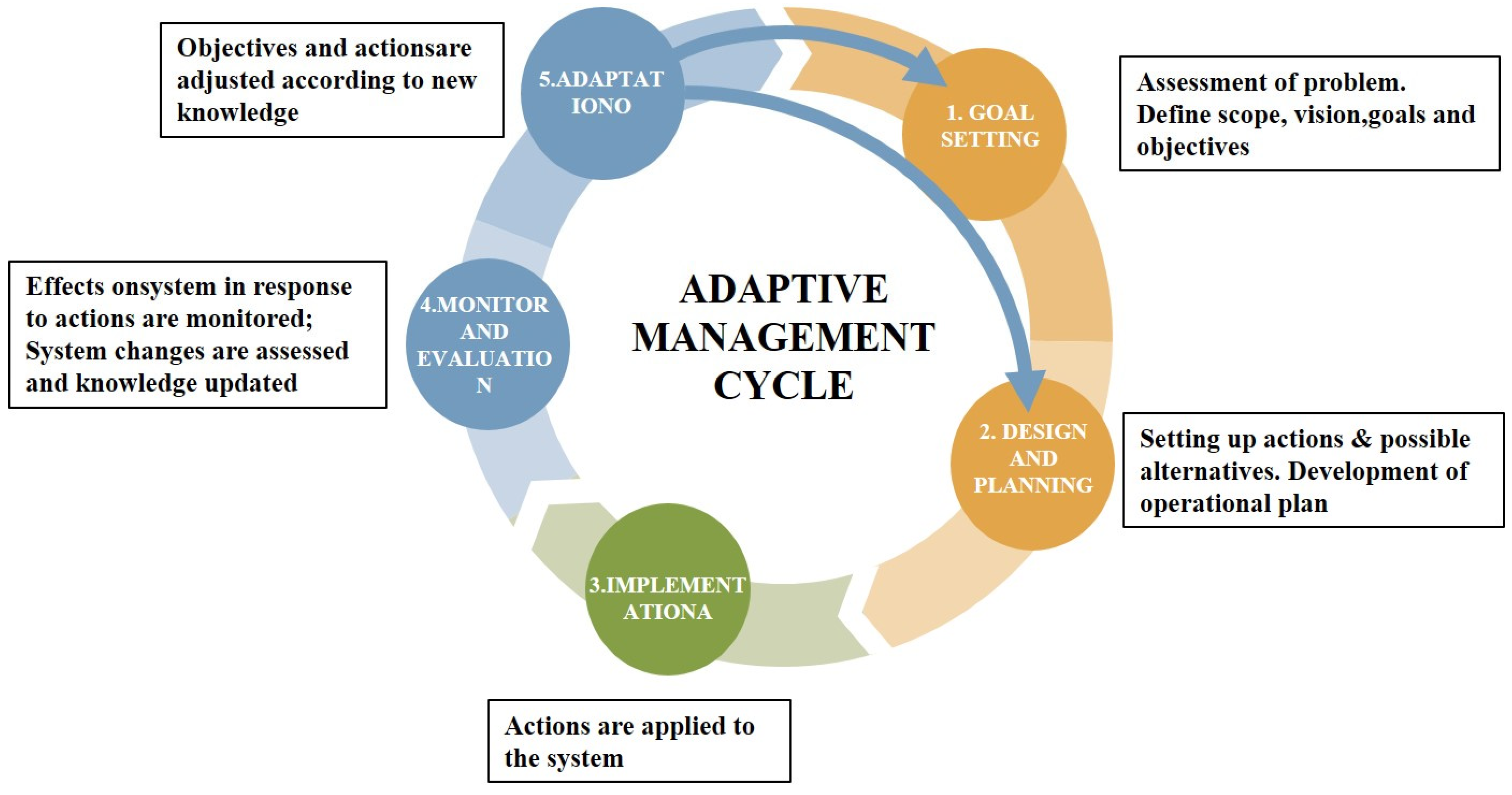
AM has been extensively employed in the realm of natural resource and conservation management since the mid-1980s. The programmatic approach to AM, notably codified by the Conservation Measures Partnership in 2005 and subsequently refined by the Puget Sound Partnership [27], has gained broad acceptance. This approach entails iterative cycles encompassing option assessment, action design and implementation, effect monitoring, impact evaluation, and strategic adaptation [28] (Figure 2). Williams (2011) proposed that adaptive management operates through single-loop learning, where goals remain stable and actions adapt to feedback, and double-loop learning, where goals and problem frameworks themselves are revised based on new knowledge [13]. Månsson et al. [29] proposition of an improved AM loop further underscores a continuous, co-learning process involving goal-setting, planning, implementation, monitoring, evaluation, and adaptation. Through ongoing monitoring and evaluation, adjustments are integrated, feeding back into the goal-setting and planning phases to refine spatial and operational strategies.
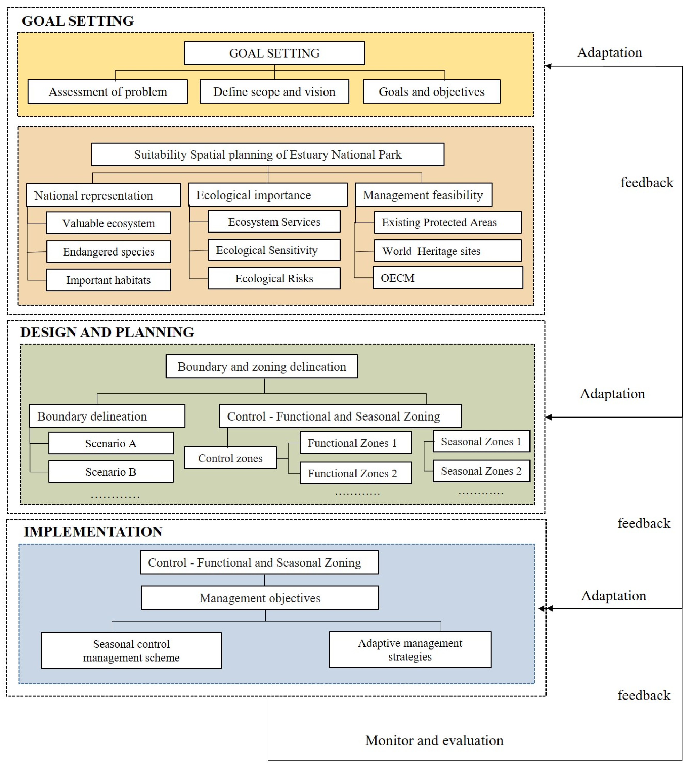
We developed a streamlined AM-oriented framework for spatial planning in Estuary National Parks (Figure 3), consisting of four interconnected phases: Goal Setting, Design and Planning, Implementation, Monitoring and Evaluation. Initially, Goal Setting involves a comprehensive problem assessment, defining scope and vision, and setting specific objectives. The ‘Suitability Spatial Planning of Estuary National Park’ approach was applied to establish conservation goals and objectives aimed at identifying a spatial plan that optimally conserves areas of national representativeness and ecological significance, while accounting for management feasibility. This process incorporated three key dimensions: national representation (including valuable ecosystems, endangered species, and key habitats), ecological importance (encompassing ecosystem services, sensitivity, and risk factors), and management feasibility (considering existing protected areas, World Heritage sites, and Other Effective Area-based Conservation Measures (OECMs)). During the Design and Planning phase, emphasis is placed on refining spatial organization through boundary delineation and zoning, supported by scenario-based spatial definitions and regulatory measures implemented via functional and seasonal zoning schemes.
The implementation phase operationalizes management objectives by enforcing zoning controls, deploying seasonal management schemes, and adopting adaptive strategies for dynamic environmental conditions. Finally, Monitoring & Evaluation closes the adaptive loop with continuous feedback, facilitating iterative improvements and ensuring effective park management amidst complex ecological and socio-economic challenges.
This study applies the AM-oriented framework to action implementation, especially in design and planning, exploring spatial planning for Estuary National Parks. Based on a thorough understanding of the Yangtze River Estuary ecosystem’s characteristics, issues, and values, the goals are to protect unique aquatic species and important bird habitats, preserve and restore ecosystem integrity, establish a national park in suitable areas for zoning and adaptive management, balance ecosystem protection with human use, and promote sustainability. The framework identifies suitable areas for national park establishment while addressing key CHNS challenges in this heavily utilized environment.

2.3. Suitability Spatial Planning of Estuary National Park

Design and planning is the core procedure and the foundation for implementing management actions. In the MSP of Estuary National Park, the spatial planning scheme is the focus, which requires assessing the suitability of spatial planning. In this study, referring to previous literature [30,31] and national park establishment standards [32,33], considering the ecosystem characteristics and conservation value of the YRE, we selected nine evaluation criteria to develop a comprehensive evaluation index system of suitability for establishing national parks in the YRE from three aspects of national representativeness, ecological importance, and management feasibility [34].

2.3.1. Evaluation Index System for the Suitability Spatial Planning of Estuary National Park

Indicator layers reflecting national ecological importance were selected from three habitat types: (1) habitats of nationally protected and endangered species, identified based on the List of Key Protected Wildlife in Shanghai; (2) habitats supporting ≥1% of the global bird population, recognizing areas of international avian conservation significance; and (3) coastal wetland ecosystems in the Yangtze River Estuary (YRE), given their unique ecological value.
A total of 30 rare and endangered waterbird species were identified in the YRE (Table S1). Among them, 22 were National Key Protected Wildlife, and 11 were Protected Birds with ≥1% of the global population size (Table S2). This list delineates key biodiversity components and conservation priorities in the region. Species distribution data were sourced from two databases: (1) the Global Biodiversity Information Facility (GBIF, https://www.gbif.org/ (accessed on 15 January 2024)), providing a large number of bird records; and (2) the China Birdwatching Center (http://www.birdreport.cn/ (accessed on 15 January 2024)), contributing historical bird occurrences. In total, 59,318 bird records, including 8040 historical occurrences, were collected, enabling a comprehensive assessment of species distribution patterns. The Kernel Density Index (KDI) was applied to the bird records to identify regions with high densities of potential species habitats. This spatial analysis method facilitated the understanding of habitat spatial distribution and informed conservation planning in the YRE.
The Chinese sturgeon, recognized as a flagship species in the Yangtze River Estuary (YRE), has been classified as globally Critically Endangered (CR) by the International Union for Conservation of Nature (IUCN). Given its ecological significance and conservation status, it was selected as a representative species for endangered aquatic organisms in this study. The MaxEnt model was employed to analyze and simulate the suitable habitats of the Chinese sturgeon [23]. This model integrates climate, physical environment, marine, and human disturbance variables (Table S3) that are associated with the historical distribution of the species at its known sites. Historical distribution data of the Chinese sturgeon in the YRE were gathered from multiple sources, namely the Global Biodiversity Information Facility (GBIF), the Ocean Biodiversity Information System (OBIS), and relevant literature [35,36]. After removing duplicate records, a total of 109 occurrence points were retained for subsequent analysis.
Environmental and anthropogenic variables influencing juvenile Chinese sturgeon habitat were selected [37], including light, food, salinity, temperature, and human activity. These were classified into physical (DEM, water depth), oceanographic, and human activity (land cover, nighttime light, ship density) variables. The bathymetric data utilized in this study were sourced from the ETOPO 2022 global topographic model, which is provided by the National Oceanic and Atmospheric Administration’s National Centers for Environmental Information (NOAA). Oceanographic data were obtained from the Bio-ORACLE dataset [38,39]. All raster data were resampled to 30 × 30 m. Using ArcMap 10.8, raster values were extracted to point layers. Variables with pairwise Pearson’s correlation >0.8 were excluded, leaving ten major variables. Processed data were imported into MaxEnt 3.4.4. 75% of data were for training and 25% for testing. 2015 land—use data trained the model, and 2020 data predicted distribution. Ten repetitions with bootstrap and Cloglog output were conducted. Model quality was evaluated by AUC and TSS. Based on occurrence probability, habitat suitability was classified into four classes, and suitable and potential habitats were defined. The final model with high AUC (0.965) and TSS (0.81) was selected [23].
The YRE lies in the freshwater–saltwater transition zone, hosting diverse coastal estuarine wetlands like silty coastal zones and mudflats. We extracted coastal wetland data from the 2022 YRE land use/land cover dataset, sourced from the National Geographic Information Center of China (NGCC) with a 30-m spatial resolution, to accurately map their distribution.

2.3.2. Ecological Importance Guidelines Layer Construction

Ecosystem service value, ecological sensitivity, and potential ecological risk were selected as evaluation indicators of ecological importance. The value of ecosystem services was calculated using the equivalent factor method adjusted with local correction factors [31,40]. Based on previous validated equivalent factor in this study area, the ecosystem service values were calculated by nine types of ecosystem service per unit area. These services include supply services (food production, raw material production), regulation services (atmospheric regulation, climate regulation, water conservation, waste disposal), support services (soil conservation, maintain biodiversity), cultural service (aesthetic landscape) (Table S4). The total value of ecosystem services is calculated for each grid cell using the Raster Calculator tool in ArcGIS 10.8 as follows [41].
V E S = a = 1 9 b = 1 6 M b × J a , b
where a represents a specific ecosystem service function, b represents a particular ecosystem type, Mb represents the total economic valuation of ecosystem services for Chongming Island, represents the areal extent of the bth ecosystem category, and Ja,b corresponds to the unit economic value of the ath ecosystem service function provided by the bth ecosystem type.
Ecological sensitivity was assessed by sensitivity factors of elevation, LULC, and other factors. Elevation data were obtained from the ASTER Global Digital Elevation Model (ASTER Global DEM) with a 30 m resolution, downloaded from the U.S. Geological Survey (USGS, https://earthexplorer.usgs.gov/ (accessed on 15 October 2023)). Once The LULC dataset used in this study had been obtained from the National Geographic Information Center of China (NGCC) obtained in 2020, which were interpreted by remote sensing data. The main potential ecological risks in the YRE are saltwater intrusion and smooth cordgrass (Spartina alterniflora) invasion. For saltwater intrusion risk assessment, we referred to Jianrong Zhu et al.’s study [42], which utilized an improved ECOM-si Princeton Ocean Model. The distribution and expansion range of smooth cordgrass were identified through Landsat remote sensing interpretation, following Shiwei Lin’s approach [43].

2.3.3. Management Feasibility Guideline Layer Construction

National parks are a way to integrate other types of protected areas into a unified and complete conservation system. Existing protected areas, World Heritage sites, and Other Effective area-based Conservation Measures (OECMs) areas are the foundation for the establishment and management of national parks, hence the need to assess these three types of existing protected areas. There were multiple existing protected areas in the YRE, including two internationally important wetlands (i.e., Chongming East tidal flat and Chinese sturgeon in the estuary of the Yangtze River, two national nature reserves, one provincial nature reserve, as well as a national wetland park, a national geopark, and a national forest park, and several primary protection zones for drinking water sources (Table S5).
Notably, the Chongming East tidal flat, which falls within the study area, has been formally inscribed as part of China’s Migratory Bird Sanctuaries along the Coast of Yellow Sea-Bohai Gulf (Phase II) on the World Heritage List. This designation was approved on 26 July 2024 during the 46th session of the UNESCO World Heritage Committee, making it Shanghai’s first World Natural Heritage site. As a result, the area will be managed in accordance with the stringent requirements for World Natural Heritage sites, significantly enhancing the feasibility and robustness of integrated conservation management. Furthermore, the YRE contains 61.5 km2 of land area and 1934.62 km2 of sea area (including overlapping regions) that fall under Shanghai’s red line for ecological protection, which are recognized as OECMs areas, contributing to the overall conservation framework.

2.3.4. Calculation of Weights and Composite Values

All evaluation index layers were rasterized to be converted into 30 × 30 m raster grid cells and normalized. The weight coefficients for each indicator were determined through the Analytic Hierarchy Process (AHP) to ensure methodological rigor and stakeholder inclusivity (Table S6). A total of 11 experts representing diverse sectors—including government agencies, protected area management departments, non-governmental organizations (NGOs), local community representatives, as well as academic scholars—were invited to participate in pairwise comparisons of the evaluation criteria. The resulting judgment matrices were examined for consistency, and all satisfied the consistency requirement (Consistency Ratio < 0.1), thereby ensuring logical reliability of the assigned weights. This participatory weighting approach enhances the transparency and credibility of the multi-attribute evaluation process. The suitability comprehensive value S was calculated for each grid cell using the Raster Calculator tool in ArcGIS 10.8 by computing the weighted comprehensive score of each indicator layer and its corresponding weight.
To compare the different indicator layers, it was essential to first normalize the individual indicator layer suitability values. Since the marker layer suitability values were all positive indicators, the normalization formula was as follows [44]:
P = x x min x max x min
In this formula, P is the evaluation value after standardized processing of the evaluation index, x is the measured value of the evaluation index, xmax is the maximum value of the evaluation index, and xmin is the minimum value of the evaluation index.
The composite value of adaptation was calculated as follows [45]:
S = i = 1 n W i × C i
In this formula, S denotes the composite value of adaptation, Wi denotes the weight of the ith indicator, and Ci denotes the standardized evaluation value of the ith indicator.

2.4. Boundary and Control—Functional and Seasonal Zoning Delineation

Based on the above analysis, the scope of the Estuary National Park is delineated, and different spatial and management alternatives are developed. According to management needs, a two-level zoning system is established, consisting of Control Zones and Functional Zones. The secondary zoning model includes management and control zoning and functional zoning. Initially, the management and control zoning delineates resource protection, clarifies the scope and intensity of human activities, and determines the Core Protection Zone and the General Control Zone. The Core Protection Zone principally prohibits human activities, but the national park management agency can carry out activities such as management and protection patrols, scientific research investigations and monitoring, and necessary facility construction, as well as other activities approved by the State Council, while ensuring that the main protected objects and the ecological environment are not harmed. The General Control Zone prohibits development and productive construction activities, allowing limited human activities such as visits and tourism that do not cause damage to ecological functions, comply with management and control requirements, and necessary public facility construction, as well as other activities stipulated by laws and administrative regulations. On this basis, functional zoning is further refined to form multiply functional zones, clarifying management objectives and actions for each zone. Furthermore, it is emphasized that the management and control model should consider the temporal and spatial dynamics of protected objects to establish seasonal zoning and implement corresponding seasonal management actions.

2.5. Implement Control Management Scheme and Management Strategies

Based on the framework of control and functional zoning, we further refined management objectives and control measures, elucidating the status of natural and cultural resources in each functional area as well as the desired visitor experience. This approach aimed to establish control measures and lists of positive and negative behaviors that aligned with the requirements of coordinated development. Furthermore, we implemented dynamic monitoring of key behaviors and indicator progress.
The management measures were primarily categorized into two dimensions: Firstly, from the perspective of protected area management institutions, we formulated specific control measures across various aspects to guide, constrain, and manage the actors within the protected areas [46]. This involved developing a comprehensive set of measures that addressed the unique characteristics and challenges of each protected area. Secondly, at the economic and social level, we encouraged and guided behaviors that benefited the surrounding areas, ensured the protection of reasonable community rights and interests, and constrained behaviors that had a negative impact on protected species and their habitats. This holistic approach integrated ecological, social, and economic considerations to achieve sustainable development goals.
Through these refined and targeted measures, we aimed to enhance the positive effects of human activities on species conservation while minimizing negative impacts. By balancing conservation and utilization, we promoted harmony between humans and nature. Additionally, we strived to avoid the pitfalls of traditional management approaches that lacked adaptability and dynamism. The refined control measures we proposed were designed to be implemented in specific spatial contexts, ensuring greater pertinence, operability, and adaptability. This approach enabled better consideration and coordination of the dual objectives of species conservation and human socio-economic development, fostering a more nuanced understanding of the complex interplay between conservation and human activities.

2.6. Verification—Calculation of the Scope and Timeshare of Shipping

Further, calculate the proportion of the proposed NPS boundaries that overlap with the extent and duration of all types of vessel traffic in the YRE in the last five years (2018–2023). Using shipping data from 2018–2023 Global Maritime Traffic (GMTDS) shipping data of all types of vessels in the YRE, the spatial and temporal overlap conflict ratio for the delineated national park boundaries and zones was calculated through spatial analysis and statistics with Zonal Statistics tool in ArcGIS 10.8. The calculation formula is as follows [47]:
P m , n = N m , n N t o t a l × 100 %
R m , n = T m , n T t o t a l × 100 %
In this formula, Pm,n represents the spatial conflict rate of shipping in the nth type of control zones of the national park in period m, m = 1, 2, n represents the protection of the core area or the general control area; Nm,n represents the number of non-zero-valued rasters of shipping data rasters located in the nth type of control zones of the national park in period m, and Ntotal represents the total number of rasters in the study area; Tm,n represents the cumulative value of the shipping data rasters located in the nth type of control zones of the national park in period m (the total area time length, h), and Ttotal represents the cumulative value of the shipping data rasters in the study area (the total time length, h).

3. Results

3.1. Evaluation Index System for the Suitability Spatial Planning of ENP

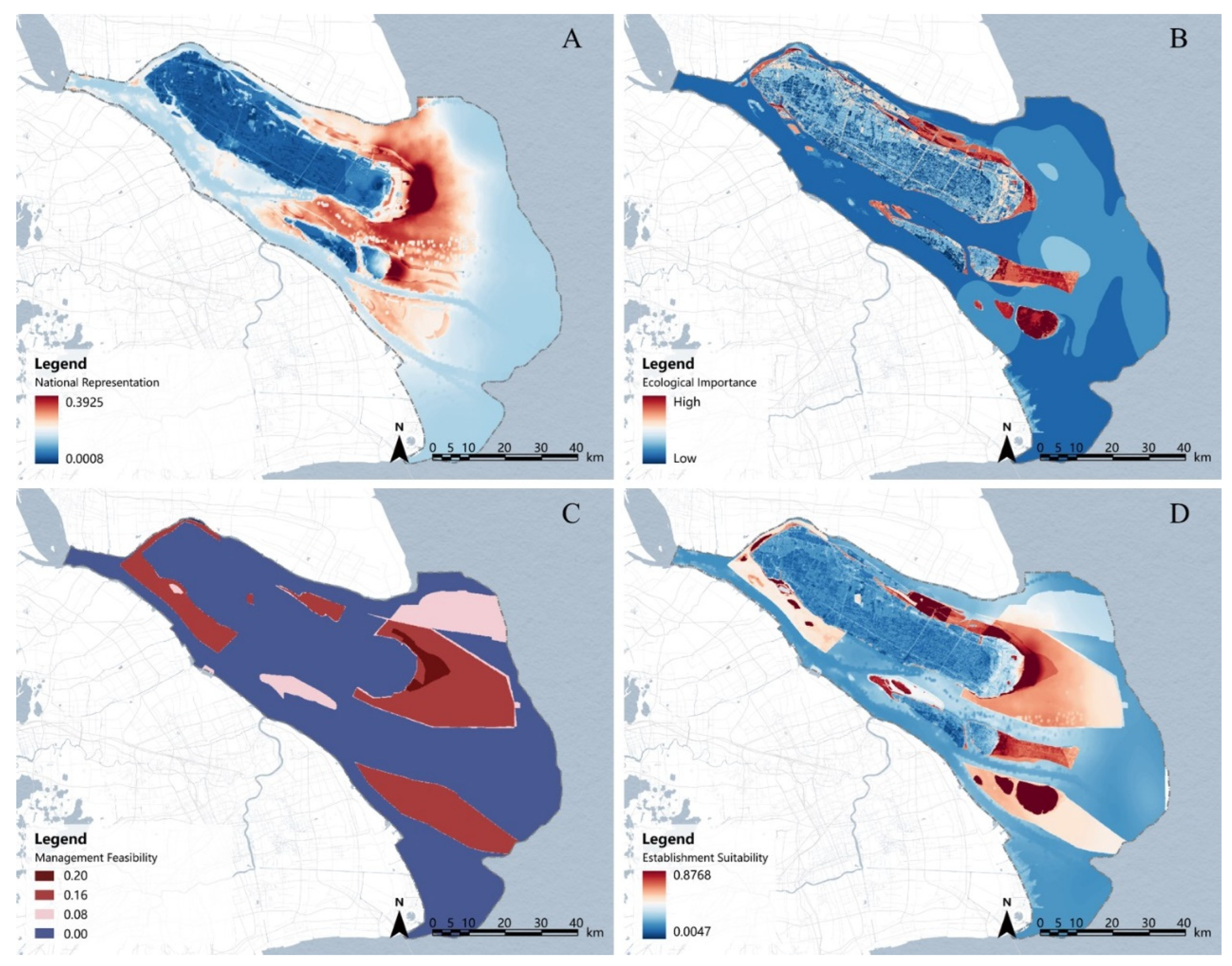
As shown in Figure 4, the evaluation results indicated notable spatial variations in national representativeness, ecological importance, and management—feasibility suitability, yet an overall similar trend. Nationally representative ecosystems and species were primarily aggregated in Chongming East tidal flat and eastern Hengsha Island. High-ecological-value areas were mainly in northern Chongming Island, Hengsha Island, and the Jiuduansha region. Feasible management zones were mainly located in the YRE’s southern branch and northern waters of Chongming, Jiuduansha, Shanghai North Lake, Chongming East tidal flat, and Dongwangsha. In the comprehensive suitability assessment, highly/suitable areas were mainly in Chongming East tidal flat and its surrounding waters, Shanghai North Lake, Jiuduansha, and western Hengsha, covering 1.5% of the total area. Moderately suitable areas, approximately 1513.22 km2 (23.9% of the total area), were mainly in the eastern and northern waters of Chongming East tidal flat, the YRE’s southern branch, northern Chongming waters, and eastern Jiuduansha.

3.2. Control—Functional and Seasonal Zoning

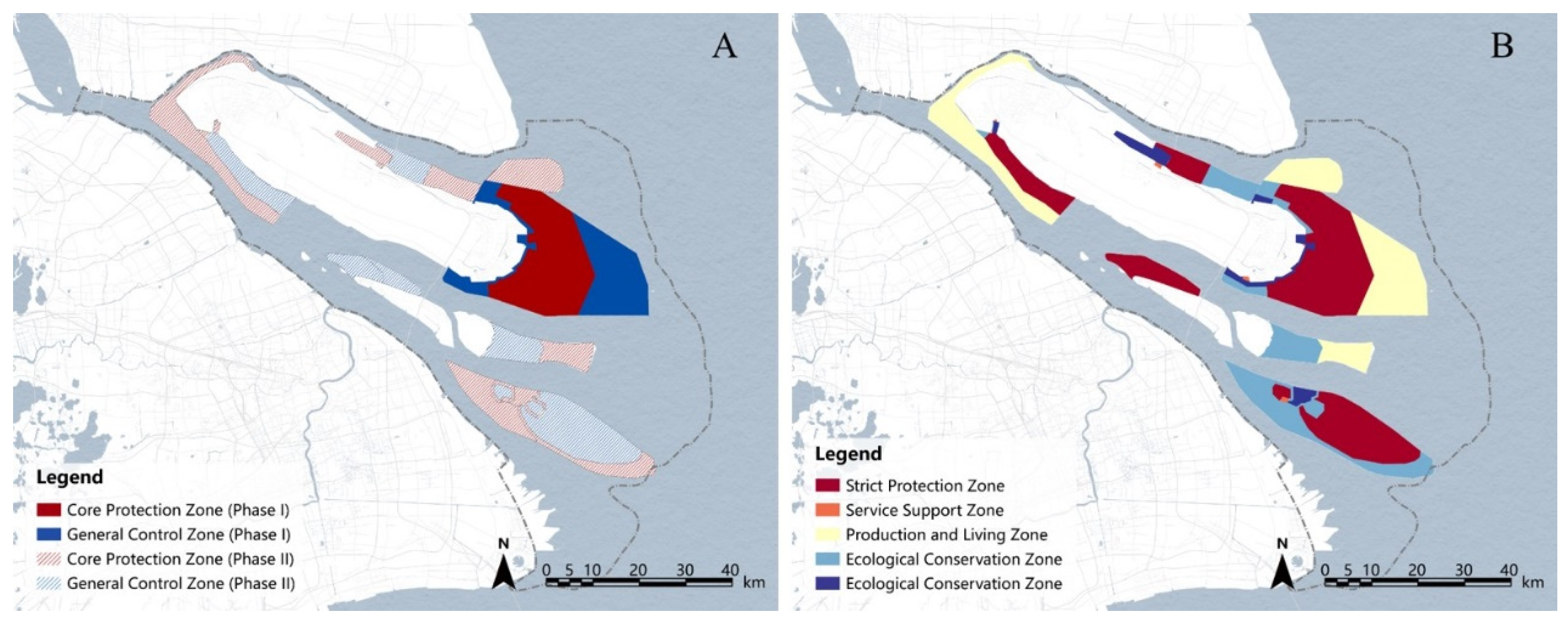
Based on the analysis, the proposed YRE National Park is delineated into core protected and general controlled areas per the national park control—zone scheme (Figure 5). Core protected areas strictly restrict human activities, except for those conducted by park management agencies, including management, patrol, scientific research, monitoring, and essential facility construction, as well as other State-Council-approved activities, ensuring no harm to key protected entities and the ecological environment. General controlled areas prohibit development and production construction, while allowing limited human activities, such as tourism and necessary public facility construction, that comply with control requirements and legal regulations and do not impair ecological functions.
The first-phase construction of the Yangtze River Estuary (YRE) National Park is recommended from the near-term to 2035, allocating 380.84 km2 and 283.54 km2 for the core protected and general control areas, respectively (Figure 5A, Table 1). In the long term, the park’s scope should expand to include all suitable areas for national park establishment to preserve YRE’s ecological integrity. The second-phase construction will enlarge the core protected and general control areas to 795.92 km2 and 852.08 km2. Based on control zones, five functional zones are proposed: strict protection, ecological conservation, production-living, science-education recreation, and service guarantee zones (Figure 5B; Table 1). Monitoring, evaluation, and management will align with each zone’s management goals.

3.3. Seasonal Zoning and Adaptive Management

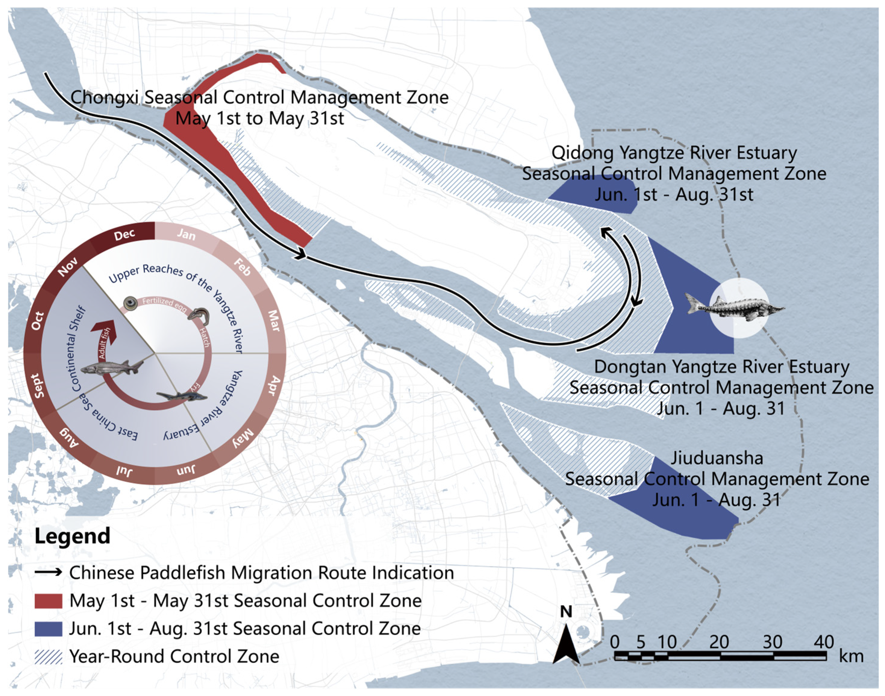
Seasonal zoning was implemented, and adaptive management strategies were developed in response to the migration corridors of Chinese sturgeon and the movement patterns of key bird species (Figure 6; Table 2). During May, when Chinese sturgeon juveniles enter the Yangtze River estuary, the estuary and its northern branch are designated as seasonal control zones. Fishing is prohibited, and mandatory speed restrictions are enforced. From June to August, Chinese sturgeons migrate to waters near Chongming East tidal flat in the YRE to forage and gradually acclimate to the marine environment. This period also coincides with the summer migration of birds. Chongming East tidal flat, the YRE, and Jiuduansha are thus designated as seasonal control areas, providing feeding and growth grounds for Chinese sturgeon and critical habitats for summer—migrating birds such as sandpipers. Furthermore, each zone continuously collects monitoring data and other relevant information, thereby providing ongoing feedback and opportunities for learning that inform the adjustment and adaptation of management strategies (Table 2).
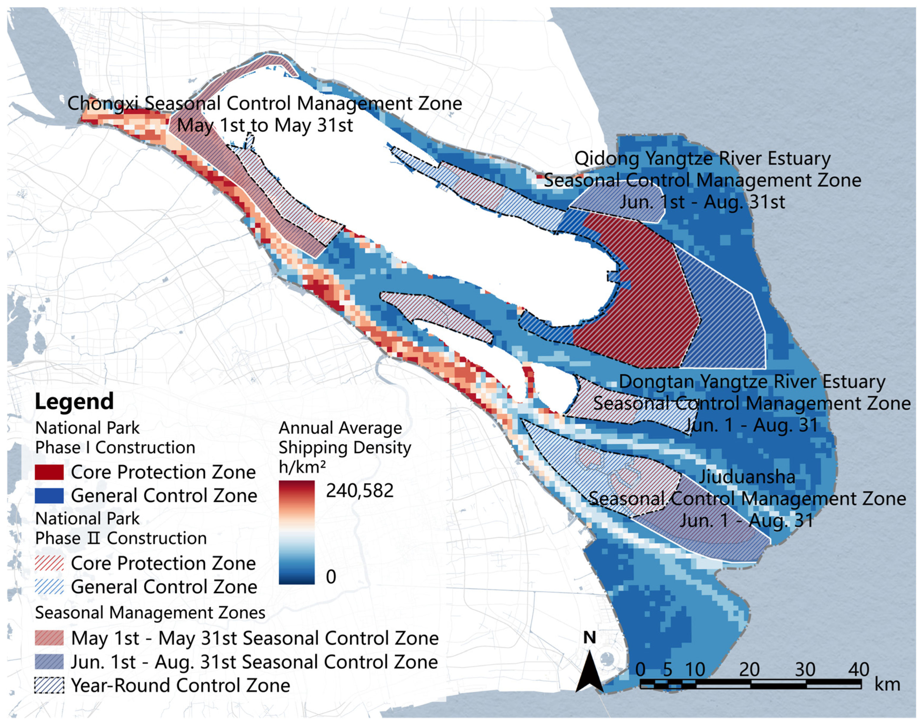
Further analysis and statistics were conducted on the space of shipping and cumulative shipping time of the proposed national park and the YRE in the past five years (2018–2023) (Figure 7). It was found that according to the scope of the first phase of planning, the overlapping area with shipping only accounted for 6.01% of the core protected area, but only 0.03% of the cumulative shipping time in the past five years, mainly for scientific research monitoring and patrol vessels; the overlapping shipping areas accounted for 4.48% of the general control area, but only 0.12% of the cumulative five-year shipping time, indicating that most areas were low-frequency shipping areas. Moreover, 73.96% of this area was the production and living area of the general control area of the national park, allowing normal navigation and other operations to be carried out without causing damage to ecological functions and meeting control requirements. In the planning scenario of expanding the construction scope in the second phase of the future, the core protection area and the general control area overlap with the shipping area by about 13%, accounting for only 1.43% and 8.13% of the cumulative five-year shipping time, respectively. Among them, 60.56% of the general control area is a seasonal control zone, which is only controlled during the stage when young fish enter the YRE for growing. It is not a thorough ban on shipping, but rather through control measures such as deceleration and prohibition of honking, to reduce the impact on the protected Chinese sturgeon. Therefore, through reasonable zoning and adaptive control strategies, the proposed national park will not have a significant impact on shipping at the YRE.

4. Discussion

Our study advances the application of AM in spatial planning for contested estuarine systems, addressing critical gaps in balancing ecological conservation and socio-economic demands within CHNS. The phased boundary delineation (Phase 1: 664.38 km2; Phase 2: 1721.94 km2) and three-tier adaptive zoning (Control–Functional–Seasonal) provide a novel approach to managing dynamic human–nature feedback in the YRE. These findings contrast with traditional static conservation models [48], yet align with emerging frameworks emphasizing flexible governance in dynamic ecosystems [49]. Specifically, our AM-integrated zoning demonstrates how seasonal adjustments can mitigate conflicts with intensive shipping activities—a challenge previously deemed intractable in highly urbanized estuaries [50]. By incorporating CHNS principles, this work extends the “dynamic governance” theory [51] to estuarine environments, offering empirical evidence that science-driven spatial planning can reconcile biodiversity protection and blue economy growth.
The proposed AM-oriented spatial planning framework for Estuary National Parks demonstrates significant advancements compared to international counterparts. While global initiatives like Australia’s Great Barrier Reef Marine Park [52] and the Chesapeake Bay Program in the U.S. Ref. [53] emphasize adaptive management, they often prioritize sectoral adjustments (e.g., fishing quotas, pollution controls) without systematically integrating spatial zoning. In contrast, our framework uniquely merges adaptive governance with multi-tier spatial delineation (Control–Functional–Seasonal Zones), enabling dynamic responses to ecological and socio-economic shifts. For instance, the seasonal zoning strategy, which restricts high-impact activities during critical breeding periods, addresses a gap observed in the European Union’s Marine Strategy Framework Directive [54], where temporal management is less explicitly operationalized. A key advantage of this framework lies in its phased implementation design. Unlike static, single-phase conservation plans (e.g., the Wadden Sea National Parks [55]), our two-phase approach allows gradual adaptation to stakeholder feedback and ecological monitoring, reducing resistance from shipping and fishing industries. Empirical validation through spatial–temporal overlap analysis with shipping routes further distinguishes this work—quantitative assessment of human activity impacts remains rare in adaptive conservation studies. The framework’s multidimensional evaluation system (national representativeness, ecological importance, management feasibility) also enhances transferability. While the Central Amazon Biosphere Reserve in Brazil uses similar ecological criteria [56], its management feasibility assessment lacks structured integration with spatial planning. This omission often leads to implementation bottlenecks, a challenge our study mitigates by aligning zoning with socio-economic realities. Nevertheless, the framework’s effectiveness relies heavily on high-quality, multidimensional spatial data covering ecological, socio-economic, and anthropogenic pressure variables. The accuracy and resolution of these datasets, which are often difficult or costly to obtain, directly affect the reliability of the spatial suitability assessments. Moreover, the long-term sustainability of the adaptive management cycle depends on continued stakeholder engagement and institutional capacity. Ensuring ongoing commitment, coordination, and funding—especially in changing socio-economic and political environments—remains a substantial practical impediment to implementation.
This study establishes a tripartite evaluation framework (national representativeness, ecological importance, management feasibility) for designating the YRE National Park. Our findings validate the YRE’s qualification as a priority conservation site due to: (1) its status as a complete ecosystem critical to the East Asian-Australasian Flyway; (2) the “three venues, one channel” ecological corridor sustaining regional biodiversity; and (3) unresolved governance fragmentation despite Shanghai’s 2023 protected area integration plan. Current Chinese national park admission criteria [32] exhibit conceptual overlaps between national representativeness and ecological importance. For instance, the YRE’s nationally representative estuarine wetlands inherently reflect ecosystem authenticity—creating metric redundancy while omitting critical vulnerability indicators. Unlike US’s National Park suitability–feasibility focus [57,58], our framework explicitly incorporates ecological sensitivity and climate risks (e.g., saltwater intrusion, storm surges) into importance assessments. This adjustment responds to the YRE’s documented “three highs, one low” profile (high openness/sensitivity/vulnerability, low stability) [59], where traditional static evaluations overlook dynamic threats from land–sea–river interactions. Failure to account for such latent risks in zoning could compromise long-term wetland integrity. Management feasibility hinges critically on land tenure—a decisive factor for national park viability in both China and the US [32,57]. Our framework prioritizes state-owned lands within existing protected designations (nature reserves, ecological redlines), ensuring: administrative tractability through leveraging established regulatory infrastructures; public benefit optimization by maximizing shared ecological assets; and stakeholder alignment via minimizing resettlement needs. The YRE exemplifies scarce resource conflicts in urbanized deltas. While integrated protected areas theoretically resolve spatial overlaps, multi-jurisdictional management and unclear tenure perpetuate governance inefficiencies [60]. Our phased boundary proposal prioritizes areas within Shanghai’s ecological redline—minimizing development conflicts [30] by building upon existing protected assets. This aligns with China’s “unified, standardized, efficient” national park directive while countering critiques that conservation constrains economic growth [61]. Critically, consolidating management under a national park authority would resolve current institutional fragmentation. This approach strategically transforms Shanghai’s ecological redline from perceived development constraint into sustainable urbanization asset [30], delivering “optimal ecological space”. The YRE case demonstrates that effective estuary conservation requires three paradigm shifts: (1) integrating dynamic vulnerability metrics with static authenticity-integrity indicators; (2) adopting phased implementation balancing ecological urgency with socioeconomic readiness; and (3) centralizing governance to overcome institutional fragmentation. This template offers transferable solutions for global mega-estuaries facing biodiversity-industry conflicts (e.g., Mississippi Delta and Rhine Estuary [62]), where future research should quantify adaptive zoning (e.g., seasonal closures) in modulating human–wildlife spatiotemporal conflicts.
The YRE is located in a highly urbanized area, and the contradiction between protection and development is particularly prominent. The YRE also undertakes important international shipping functions, and Shanghai Port is the port with the most container routes, the densest shipping schedule, and the widest coverage in China. In 2021, the container throughput of Shanghai Port exceeded 47 million TEUs, a year-on-year increase of 8%, ranking first in the world for 12 consecutive years. The establishment of national parks has become the biggest concern for relevant departments, as it affects the international shipping function and restricts the economic development of Shanghai, hindering the process of promoting overall protection. This is also one of the biggest reasons why the construction of the YRE National Park was not selected in the National Park Spatial Layout Plan due to the clear representation and high ecological value of the YRE National Park in the preliminary research of China’s national park spatial layout [63]. The Implementation Plan for Shanghai to Implement the Outline of the Yangtze River Delta Regional Integration Development Plan, issued in January 2020, clearly proposed to accelerate the planning and research work of the YRE National Park and promote the construction of Chongming’s world-class ecological island at a high level. Previous studies have demonstrated the feasibility of establishing the YRE National Park [30,60], which not only does not bring additional constraints, but can also integrate world-class ecological resources to promote ecological integration in the Yangtze River Delta. The results of this study indicate that the proposed national park and the YRE have limited shipping channel space and cumulative shipping time in the past five years (2018–2023), with little impact on shipping scope and intensity. This is consistent with the previous research findings [30] that the construction of the YRE National Park will not affect the function of the international shipping center.
Moreover, international experience has proven [64] that achieving holistic protection through the establishment of national parks, flexible adjustment of adaptive management according to species protection needs, and the addition of seasonal and temporary zones can achieve coordinated development of protection and utilization, and solve the problems of protection and development. According to the life history of the flagship aquatic species of Chinese sturgeon in the YRE, after the construction of the Gezhouba Hydropower Station, sexually mature individuals swim upstream to Gezhouba to lay eggs. The following year, juvenile fish enter the northern branch of the YRE in May and swim to the waters near the Chongming East Beach of the YRE from June to August to feed and grow, gradually adapting to the marine environment [35,37]. This stage is the rapid growth and development of the Chinese sturgeon, which requires a complete transformation from freshwater to saltwater. It is crucial for the protection of the Chinese sturgeon [65]. After September, the Chinese sturgeon enters the sea for fattening and continues to forage and grow. Based on the protection needs of Chinese sturgeon [66,67] and international experience [64], it is recommended to carry out seasonal management zoning and adaptive management, to monitor and record the entry of Chinese sturgeon juveniles into the YRE in real time. During the seasonal control period (usually from May to September), it is required to avoid entering ships as much as possible, or reduce the speed and prohibit honking, reduce interference, and adjust management strategies through real-time feedback to achieve a balance between protection and development. Furthermore, the extensive tidal marshes and flats along China’s coastlines and estuaries serve as critical zones for carbon storage within the country’s blue carbon ecosystems [68], and the establishment of the Yangtze River Estuary National Park is expected to further enhance the conservation and sequestration potential of these vital blue carbon reservoirs. Subsequent studies could focus on monitoring the dynamics of organic carbon and identifying key influencing factors [69]. Integrating these organic carbon metrics into the adaptive management framework as core indicators would be essential for assessing ecosystem health and refining conservation strategies under climate change.
Our findings suggests that the establishment of the YRE National Park represents a groundbreaking application of CHNS theory to reconcile ecological conservation with socioeconomic development in highly urbanized estuaries [30]. The YRE is also an important water source in the Yangtze River Delta region. Protecting the ecological environment of the YRE is also of great significance for ensuring the security of water resources in the Yangtze River Delta region [60]. In addition, establishing the YRE National Park will help enhance the international influence of Shanghai city [31,60]. By implementing an adaptive management framework featuring three-tier zoning (Control–Functional–Seasonal), we have created institutional mechanisms that maintain critical feedback loops between ecological monitoring (e.g., sturgeon migration patterns) and management adjustments, while quantitatively balancing competing ecosystem services (flood regulation, water purification) with economic activities (shipping, tourism). The CHNS-based approach has achieved remarkable synergies, including improvement in water retention services alongside growth in port operations, demonstrating how science-driven spatial planning can transform traditional conservation-development conflicts into mutually reinforcing relationships. These innovations directly support China’s Yangtze River Protection Strategy and Shanghai’s ecological city development through nature-based solutions. Globally, the framework offers transferable protocols for managing similar CHNS challenges in the Mekong and Nile Deltas, where preliminary assessments suggest remarkable reductions in land use conflicts could be achieved. Most significantly, the YRE case redefines protected area governance as a dynamic CHNS optimization process rather than static spatial demarcation, providing measurable solutions to the “conservation versus development” paradox that has long hindered sustainable management of intensively utilized estuaries worldwide.

5. Conclusions

This study developed an AM-oriented spatial planning framework for the YRE National Park, addressing critical gaps in balancing ecological conservation, water resource management, and human activities like shipping. By systematically evaluating the YRE’s suitability for national park establishment through a comprehensive assessment system (national representativeness, ecological importance, management feasibility), we delineated a phased park boundary (Phase 1: 664.38 km2; Phase 2: 1721.94 km2) and established three-tier adaptive zoning (Control Zones, Functional Zones and Seasonal Zones) to integrate ecological integrity with socio-economic constraints. Key findings demonstrate that AM strategies, including seasonal/temporary zoning, enable flexible adjustments to species protection needs while minimizing conflicts with shipping activities (limited spatial–temporal overlap over five years). This framework, validated by international experience in holistic estuary conservation, provides a science-driven, transferable model for global contested seascapes. The study contributes theoretically by advancing AM-integrated spatial planning for estuaries and practically by supporting China’s national strategies for Yangtze River protection and high-quality regional development. Policymakers are recommended to adopt phased implementation, rigorous boundary demarcation, and adaptive governance to ensure ecological stability, biodiversity preservation, and sustainable economic growth in the Yangtze River Delta.
Limitations include constraints in long-term ecological data and dynamic ecosystem assessments. Future research should enhance multidisciplinary integration, refine originality/integrity evaluations of the YRE ecosystem, and prioritize real-time monitoring to strengthen adaptive planning resilience. Moreover, greater efforts are needed to systematically integrate stakeholders’ concerns and values into spatial planning processes. This work underscores the potential of AM frameworks to reconcile conservation and development, offering a replicable paradigm for sustainable estuary management worldwide.

Supplementary Materials

The following supporting information can be downloaded at: https://www.mdpi.com/article/10.3390/w17203002/s1, Table S1: The list of rare and endangered species in the YRE; Table S2: Priority protected waterbird in the YRE that have reached 1% of the global population size; Table S3: Environmental variables and data sources for Chinese sturgeon (Acipenser sinensis) habitats in the YRE; Table S4 Revision of the Ecosystem Service Value Equivalent Table for Chongming Island; Table S5: Status and management of existing protected areas in the YRE; Table S6: Evaluation index system for the suitability of establishing the YRE National Park.

Author Contributions

Conceptualization, Z.Z., W.C. and W.P.; methodology, Z.Z., W.C. and Y.L.; software, J.L. and W.Y.; validation, W.P. and W.C.; formal analysis, J.L., Y.L., Z.Z. and W.Y.; investigation, Z.Z., C.W., W.Y. and W.P.; resources, W.P. and W.C.; data curation, J.L. and Y.L.; writing—original draft preparation, Q.Z., C.W. and W.P.; writing—review and editing, Z.Z., Q.Z., W.C. and W.P.; visualization, J.L. and Y.L.; supervision, W.C. and W.P.; project administration, W.P.; funding acquisition, W.C. and W.P. All authors have read and agreed to the published version of the manuscript.

Funding

This research was funded by the National Natural Science Foundation of China (Grant No. 52208066; 72104232), Shanghai Sailing Program (Grant No. 21YF1419600), Fundamental Research Funds for the Central Universities, National Social Science Fund (Grant No. 20FGLB014), and the Shanghai Urban Planning and Design Research Institute (Grant No.92600-412321-22192).

Data Availability Statement

The data presented in this study are available on request from the corresponding author due to research purposes.

Acknowledgments

Thank Ping Zhuang of the East China Sea Fisheries Research Institute of the Chinese Academy of Fishery Sciences for providing valuable information and books; Thank Shanghai Chongming Dongtan Bird National Nature Reserve Management Affairs Center and the East China Sea Development Research Institute of the Ministry of Natural resources for their support and help; Thanks to Peng Peilin, Lu Anyi, Deng Yicheng and Hong Jun for their participation and contributions. During the preparation of this manuscript, the author(s) used DeepSeek-V3 for the purposes of improving language. The authors have reviewed and edited the output and take full responsibility for the content of this publication.

Conflicts of Interest

The authors declare no conflicts of interest.

References

  1. Tang, Y.; Pi, J.; Yang, S.; Liu, X.; Xiang, J.; Bian, C.; Li, D. Chromosome-level genome assembly of the estuarine Corbicula flumnalis from the Yangtze River estuary in China. Sci. Data 2025, 12, 863. [Google Scholar] [CrossRef] [PubMed]
  2. Keyes, A.A.; McLaughlin, J.P.; Barner, A.K.; Dee, L.E. An ecological network approach to predict ecosystem service vulnerability to species losses. Nat. Commun. 2021, 12, 1586. [Google Scholar] [CrossRef] [PubMed]
  3. Halpern, B.S.; Walbridge, S.; Selkoe, K.A.; Kappel, C.V.; Micheli, F.; D’Agrosa, C.; Bruno, J.F.; Casey, K.S.; Ebert, C.; Fox, H.E.; et al. A global map of human impact on marine ecosystems. Science 2008, 319, 948–952. [Google Scholar] [CrossRef] [PubMed]
  4. Bugnot, A.B.; Mayer-Pinto, M.; Airoldi, L.; Heery, E.C.; Johnston, E.L.; Critchley, L.P.; Strain, E.M.A.; Morris, R.L.; Loke, L.H.L.; Bishop, M.J.; et al. Current and projected global extent of marine built structures. Nat. Sustain. 2020, 4, 33–41. [Google Scholar] [CrossRef]
  5. Halpern, B.S.; Frazier, M.; Afflerbach, J.; Lowndes, J.S.; Micheli, F.; O’Hara, C.; Scarborough, C.; Selkoe, K.A. Recent pace of change in human impact on the world’s ocean. Sci. Rep. 2019, 9, 11609. [Google Scholar] [CrossRef]
  6. Shrestha, N.; Xu, X.; Meng, J.; Wang, Z. Vulnerabilities of protected lands in the face of climate and human footprint changes. Nat. Commun. 2021, 12, 1632. [Google Scholar] [CrossRef]
  7. CBD Secretariat. The final text of the historic Kunming-Montreal Global Biodiversity Framework. In Proceedings of the 15th Meeting of the Conference of Parties to the UN Convention on Biological Diversity, Montreal, QC, Canada, 22 December 2022. [Google Scholar]
  8. Halpern, B.S.; Frazier, M.; Potapenko, J.; Casey, K.S.; Koenig, K.; Longo, C.; Lowndes, J.S.; Rockwood, R.C.; Selig, E.R.; Selkoe, K.A.; et al. Spatial and temporal changes in cumulative human impacts on the world’s ocean. Nat. Commun. 2015, 6, 7615. [Google Scholar] [CrossRef]
  9. Sala, E.; Mayorga, J.; Bradley, D.; Cabral, R.B.; Atwood, T.B.; Auber, A.; Cheung, W.; Costello, C.; Ferretti, F.; Friedlander, A.M.; et al. Protecting the global ocean for biodiversity, food and climate. Nature 2021, 592, 397–402. [Google Scholar] [CrossRef]
  10. Hu, W.; Liu, J.; Ma, Z.; Wang, Y.; Zhang, D.; Yu, W.; Chen, B. China’s marine protected area system: Evolution, challenges, and new prospects. Mar. Policy 2020, 115, 103780. [Google Scholar] [CrossRef]
  11. Peng, W.; López-Carr, D.; Wu, C.; Wang, X.; Longcore, T. What factors influence the willingness of protected area communities to relocate? China’s ecological relocation policy for Dashanbao Protected Area. Sci. Total Environ. 2020, 727, 138364. [Google Scholar] [CrossRef]
  12. Varley, N.; Boyce, M.S. Adaptive management for reintroductions: Updating a wolf recovery model for Yellowstone National Park. Ecol. Model. 2006, 193, 315–339. [Google Scholar] [CrossRef]
  13. Williams, B.K. Adaptive management of natural resources—Framework and issues. J. Environ. Manag. 2011, 92, 1346–1353. [Google Scholar] [CrossRef] [PubMed]
  14. Deitch, M.J.; Gancel, H.N.; Croteau, A.C.; Caffrey, J.M.; Scheffel, W.; Underwood, B.; Muller, J.W.; Boudreau, D.; Cantrell, C.G.; Posner, M.J.; et al. Adaptive management as a foundational framework for developing collaborative estuary management programs. J. Environ. Manag. 2021, 295, 113107. [Google Scholar] [CrossRef] [PubMed]
  15. Rasch, D. Walters, C.: Adaptive management of renewable resources. MacMillan Publishing Company, New York 1986, 374 pp., 55 figs., 10 tab., DM 69,90. Biom. J. 1989, 31, 758. [Google Scholar] [CrossRef]
  16. Holling, C.S.; Meffe, G.K. Command and control and the pathology of natural resource management. Conserv. Biol. 1996, 10, 328–337. [Google Scholar] [CrossRef]
  17. Webb, J.A.; Watts, R.J.; Allan, C.; Warner, A.T. Chapter 25-Principles for Monitoring, Evaluation, and Adaptive Management of Environmental Water Regimes. In Water for the Environment; Horne, A.C., Webb, J.A., Stewardson, M.J., Richter, B., Acreman, M., Eds.; Academic Press: Cambridge, MA, USA, 2017; pp. 599–623. [Google Scholar]
  18. Mitra, A.; Zaman, S. Estuarine Ecosystem: An Overview. In Basics of Marine and Estuarine Ecology; Mitra, A., Zaman, S., Eds.; Springer India: New Delhi, India, 2016; pp. 21–52. [Google Scholar]
  19. Jones, E.L.; Sparling, C.E.; McConnell, B.J.; Morris, C.D.; Smout, S. Fine-scale harbour seal usage for informed marine spatial planning. Sci. Rep. 2017, 7, 11581. [Google Scholar] [CrossRef]
  20. Hammar, L.; Molander, S.; Palsson, J.; Schmidtbauer Crona, J.; Carneiro, G.; Johansson, T.; Hume, D.; Kagesten, G.; Mattsson, D.; Tornqvist, O.; et al. Cumulative impact assessment for ecosystem-based marine spatial planning. Sci. Total Environ. 2020, 734, 139024. [Google Scholar] [CrossRef]
  21. Loiseau, C.; Thiault, L.; Devillers, R.; Claudet, J. Cumulative impact assessments highlight the benefits of integrating land-based management with marine spatial planning. Sci. Total Environ. 2021, 787, 147339. [Google Scholar] [CrossRef]
  22. Ye, G.; Fei, J.; Wang, Z.; Jiang, Q.; Gaines, S.D.; Ming, C.L. A novel marine spatial management tool for multiple conflicts recognition and optimization of marine functional zoning in the East China sea. J. Environ. Manag. 2021, 298, 113506. [Google Scholar] [CrossRef]
  23. Yang, W.; Zhu, Z.; Dong, L.; Peng, W.; Wu, C. Using cumulative human impact assessment to support adaptive management of the threatened species’ habitats in the Yangtze River Estuary. Glob. Ecol. Conserv. 2024, 54, e03164. [Google Scholar] [CrossRef]
  24. Gao, Y.; Zhang, L.; Zhang, T.; Liu, J.; Song, C.; Zhuang, P. The Status of Wetland Conservation and Management, the Existing Problems and Solution Ways in the Yangtze Estuary. Wetl. Sci. 2017, 15, 302–308. [Google Scholar] [CrossRef]
  25. Wu, S.; Chen, R.; Meadows, M.E. Evolution of an Estuarine Island in the Anthropocene: Complex Dynamics of Chongming Island, Shanghai, P.R. China. Sustainability 2019, 11, 6921. [Google Scholar] [CrossRef]
  26. Chen, Y.; Liu, S.; He, Y.; Qin, Y.; Ji, X.; Zhang, H.; Xu, R. Study on ecosystem health and variation trend at the Changjiang River Estuary in the past 30 years. Haiyang Xuebao 2020, 42, 55–65. [Google Scholar] [CrossRef]
  27. Schwartz, M.W.; Deiner, K.; Forrester, T.; Grof-Tisza, P.; Muir, M.J.; Santos, M.J.; Souza, L.E.; Wilkerson, M.L.; Zylberberg, M. Perspectives on the Open Standards for the Practice of Conservation. Biol. Conserv. 2012, 155, 169–177. [Google Scholar] [CrossRef]
  28. Georgiadis, N. Adaptive Management: What, Why, and How? University of Washington Puget Sound Institute: Tacoma, WA, USA, 2016. [Google Scholar]
  29. Månsson, J.; Eriksson, L.; Hodgson, I.; Elmberg, J.; Bunnefeld, N.; Hessel, R.; Johansson, M.; Liljebäck, N.; Nilsson, L.; Olsson, C.; et al. Understanding and overcoming obstacles in adaptive management. Trends Ecol. Evol. 2023, 38, 55–71. [Google Scholar] [CrossRef]
  30. Su, H.; Su, Y.; Lin, H. Research on the relationship between National Parks and Regional Development: Taking Shanghai Eco-city Construction as an Example. Environ. Prot. 2020, 48, 49–54. [Google Scholar] [CrossRef]
  31. Lu, Z. Research on the Value and Sensitivity of Ecosystem Services of Chongming Island; Shanghai Normal University: Shanghai, China, 2018. [Google Scholar]
  32. GB/T 39739-2020; Specification for National Park Establishment. State Administration for Market Regulation; National Standarlization Administration: Beijing, China, 2020.
  33. GB/T 39736-2020; Technical Specification for the National Park Master Plan. State Administration for Market Regulation; National Standarlization Administration: Beijing, China, 2020.
  34. Peng, W.; Zhu, Z.; Liu, J.; Lin, Y.; Yang, W.; Cai, W.; Wu, C. Assessment of the ecosystem characteristics and conservation value of the Yangtze River Estuary. Natl. Park 2024, 2, 91–100. [Google Scholar] [CrossRef]
  35. Zhuang, P.; Li, D.; Zhang, T. Environmental Biology of Sturgeons and Paddlefishes Growth; Development and the Enironment; Science Press: Beijing, China, 2017. [Google Scholar]
  36. Zhuang, P.; Zhang, T.; Li, S.; Ni, Y.; Wang, Y. Fishes of the Yangtze Estuary, 2nd ed.; China Agriculture Press: Beijing, China, 2018. [Google Scholar]
  37. Wang, S.; Zhang, T.; Yang, G.; Wang, Y.; Zhao, F.; Zhuang, P. Migration and feeding habits of juvenile Chinese sturgeon (Acipenser sinensis Gray 1835) in the Yangtze Estuary: Implications for conservation. Aquat. Conserv. Mar. Freshw. Ecosyst. 2018, 28, 1329–1336. [Google Scholar] [CrossRef]
  38. Assis, J.; Tyberghein, L.; Bosh, S.; Verbruggen, H.; Serrão, E.A.; De Clerck, O. Bio-ORACLE v2.0: Extending marine data layers for bioclimatic modelling. Glob. Ecol. Biogeogr. 2018, 27, 277–284. [Google Scholar] [CrossRef]
  39. Tyberghein, L.; Verbruggen, H.; Pauly, K.; Troupin, C.; Mineur, F.; Clerck, O.D. Bio-ORACLE: A global environmental dataset for marine species distribution modelling. Glob. Ecol. Biogeogr. 2012, 21, 272–281. [Google Scholar] [CrossRef]
  40. Yang, H.; Liu, G. Valuation of ecosystem services in Yangtze River Estuary. Mar. Environ. Sci. 2008, 385, 135601. [Google Scholar]
  41. Xie, G.; Zhang, C.; Zhang, L.; Chen, W.; Li, S. Improvement of the Evaluation Method for Ecosystem Service Value Based on Per Unit Area. J. Nat. Resour. 2015, 30, 1243–1254. [Google Scholar] [CrossRef]
  42. Zhu, J.; Wu, H.; Li, L.; Qiu, C. Saltwater Intrusion in the Changjiang Estuary. In Coastal Environment, Disaster, and Infrastructure-A Case Study of China’s Coastline; InTechOpen: London, UK, 2018; pp. 49–73. [Google Scholar]
  43. Lin, S. Quantitative Assessment of Tidal Wetlands Degradation and the Identification of Priority Areas for Ecological Restoration in Shanghai City; East China Normal University: Shanghai, China, 2021. [Google Scholar]
  44. Ma, B.; Zeng, W.; Xie, Y. The functional zoning method for natural parks: A case study of Huangshan Scenic Area. Acta Ecol. Sin. 2019, 39, 8286–8298. [Google Scholar] [CrossRef]
  45. Xiao, L.; Zhong, L.; Yu, H.; Zhou, R. Assessment of recreational use suitability of Qianjiangyuan National Park Pilot under the zoning constraints. Acta Ecol. Sin. 2019, 39, 1375–1384. [Google Scholar] [CrossRef]
  46. Yaffee, S.L. Beyond Polarization: Public Process and the Unlikely Story of California’s Marine Protected Areas; Island Press: Washington, DC, USA, 2020. [Google Scholar]
  47. Metcalfe, K.; Bréheret, N.; Chauvet, E.; Collins, T.; Curran, B.K.; Parnell, R.J.; Turner, R.A.; Witt, M.J.; Godley, B.J.; Grantham, H. Using satellite AIS to improve our understanding of shipping and fill gaps in ocean observation data to support marine spatial planning. J. Appl. Ecol. 2018, 55, 1834–1845. [Google Scholar] [CrossRef]
  48. Noble, M.M.; Harasti, D.; Fulton, C.J.; Doran, B. Identifying spatial conservation priorities using Traditional and Local Ecological Knowledge of iconic marine species and ecosystem threats. Biol. Conserv. 2020, 249, 108709. [Google Scholar] [CrossRef]
  49. Oestreich, W.K.; Chapman, M.S.; Crowder, L.B. A comparative analysis of dynamic management in marine and terrestrial systems. Front. Ecol. Environ. 2020, 18, 496–504. [Google Scholar] [CrossRef]
  50. Maxwell, S.M.; Hazen, E.L.; Lewison, R.L.; Dunn, D.C.; Bailey, H.; Bograd, S.J.; Briscoe, D.K.; Fossette, S.; Hobday, A.J.; Bennett, M.; et al. Dynamic ocean management: Defining and conceptualizing real-time management of the ocean. Mar. Policy 2015, 58, 42–50. [Google Scholar] [CrossRef]
  51. Gunderson, L.H.; Cosens, B.; Garmestani, A.S. Adaptive governance of riverine and wetland ecosystem goods and services. J. Environ. Manag. 2016, 183, 353–360. [Google Scholar] [CrossRef]
  52. McCook, L.J.; Ayling, T.; Cappo, M.; Choat, J.H.; Evans, R.D.; De Freitas, D.M.; Heupel, M.; Hughes, T.P.; Jones, G.P.; Mapstone, B.; et al. Adaptive management of the Great Barrier Reef: A globally significant demonstration of the benefits of networks of marine reserves. Proc. Natl. Acad. Sci. USA 2010, 107, 18278–18285. [Google Scholar] [CrossRef]
  53. Hennessey, T.M. Governance and adaptive management for estuarine ecosystems: The case of Chesapeake Bay. Coast. Manag. 1994, 22, 119–145. [Google Scholar] [CrossRef]
  54. EC. Directive 2008/56/EC of the European Parliament and of the Council of 17 June 2008 Establishing a Framework for Community Action in the Field of Marine Environmental Policy (Marine Strategy Framework Directive) (Text with EEA Relevance). 2008, pp. 19–40. Available online: https://eur-lex.europa.eu/eli/dir/2008/56/oj (accessed on 14 October 2025).
  55. Enemark, J. The Wadden Sea protection and management scheme—Towards an integrated coastal management approach? Ocean Coast. Manag. 2005, 48, 996–1015. [Google Scholar] [CrossRef]
  56. Foundation for Amazon Sustainability; Secretary of State for the Environment of Amazons. Action Plan for the Central Amazon Biosphere Reserve: PARBAC (2021–2024): Executive Summary; Foundation for Amazon Sustainability; Secretary of State for the Environment of Amazons: Amazonas, Brazil, 2021. [Google Scholar]
  57. Ouyang, Z.; Tang, X.; Du, A.; Zang, Z.; Xu, W. Building China’s national park systems scientifically: Challenges and opportunities. Natl. Park 2023, 1, 67–74. [Google Scholar] [CrossRef]
  58. Wu, C.; Yu, H.; Kou, M. Recent Advances for Research and Practice of National Parks and Protected Areas in China: Summary of the 2012–2022 the Sixth Seminar of Ecological Civilization and National Parks System. Landsc. Archit. Acad. J. 2022, 39, 4–10. [Google Scholar] [CrossRef]
  59. Gao, Y.; Huang, X.; Zhang, T.; Wang, Y.; Yang, G.; Zhuang, P. Research Advances in Coastal Estuarine Wetland Ecosystem in China: A Case Study of the Yangtze Estuary. Wetl. Sci. Manag. 2016, 12, 59–63. [Google Scholar] [CrossRef]
  60. Shen, Q. After “Birds Flying and Fish Leaping,” How to Create a High-Quality Ecological Space at the Yangtze River Estuary. Wenhui Daily. 17 January 2021. Available online: https://www.whb.cn/zhuzhan/kjwz/20210117/388521.html (accessed on 17 October 2025).
  61. Liu, S.; Cai, F.; He, Y.; Qi, H.; Rangel-Buitrago, N.; Liu, J.; Zheng, J. Integrating marine functional zoning in coastal planning: Lessons from the Xiasha Beach Resort case study. Ocean Coast. Manag. 2024, 249, 107016. [Google Scholar] [CrossRef]
  62. van der Voorn, T.; Quist, J.; Pahl-Wostl, C.; Haasnoot, M. Envisioning robust climate change adaptation futures for coastal regions: A comparative evaluation of cases in three continents. Mitig. Adapt. Strateg. Glob. Change 2015, 22, 519–546. [Google Scholar] [CrossRef]
  63. Tang, X.; Ouyang, Z.; Jiang, Y.; Ma, W.; Xu, W.; Chen, S.; Liu, Z. Spatial planning of nation park in China. Natl. Park 2023, 1, 1–10. [Google Scholar] [CrossRef]
  64. Zhang, Y.; Du, C.; Su, Y. International Experience of Adaptive Management of Wildlife Habitat Conservation and Its Enlightenments to the National Park Construction in China. Chin. Landsc. Archit. 2022, 38, 63–68. [Google Scholar] [CrossRef]
  65. Ke, F.; Wei, Q.; Zhang, G.; Hu, D.; Luo, J.; Zhuang, P. Investigations on the structure of spawning population of Chinese sturgeon (Acipenser sinensis) and the estimation of its stock. Freshw. Fish. 1992, 4, 7–11. [Google Scholar]
  66. Wei, Q. Conservation of Chinese sturgeon (Acipenser sinensis) based on its life history: Dilemma and breakthrough. J. Lake Sci. 2020, 32, 1297–1319. [Google Scholar] [CrossRef]
  67. Zhu, J.; Guo, W.; Li, Z.; Jiang, W. First Insights into the Migration Route and Spatial Distribution of the Endangered Chinese Sturgeon (Acipenser sinensis) in the Yangtze River Estuary. Fishes 2024, 9, 321. [Google Scholar] [CrossRef]
  68. Sun, S.; Song, Z.; Guo, L.; Duarte, C.M.; Macreadie, P.I.; Zhang, Z.; Fang, Y.; Chen, B.; Wang, Z.; Wang, W.; et al. A Spatial Baseline of China’s Blue Carbon Stocks for Improved Monitoring, Management, and Protection. Earth’s Future 2025, 13, e2024EF005380. [Google Scholar] [CrossRef]
  69. Mei, W.; Dong, H.; Qian, L.; Yan, J.; Hu, Y.; Wang, L. Effects of anthropogenic disturbances on the carbon sink function of Yangtze River estuary wetlands: A review of performance, process, and mechanism. Ecol. Indic. 2024, 159, 111643. [Google Scholar] [CrossRef]
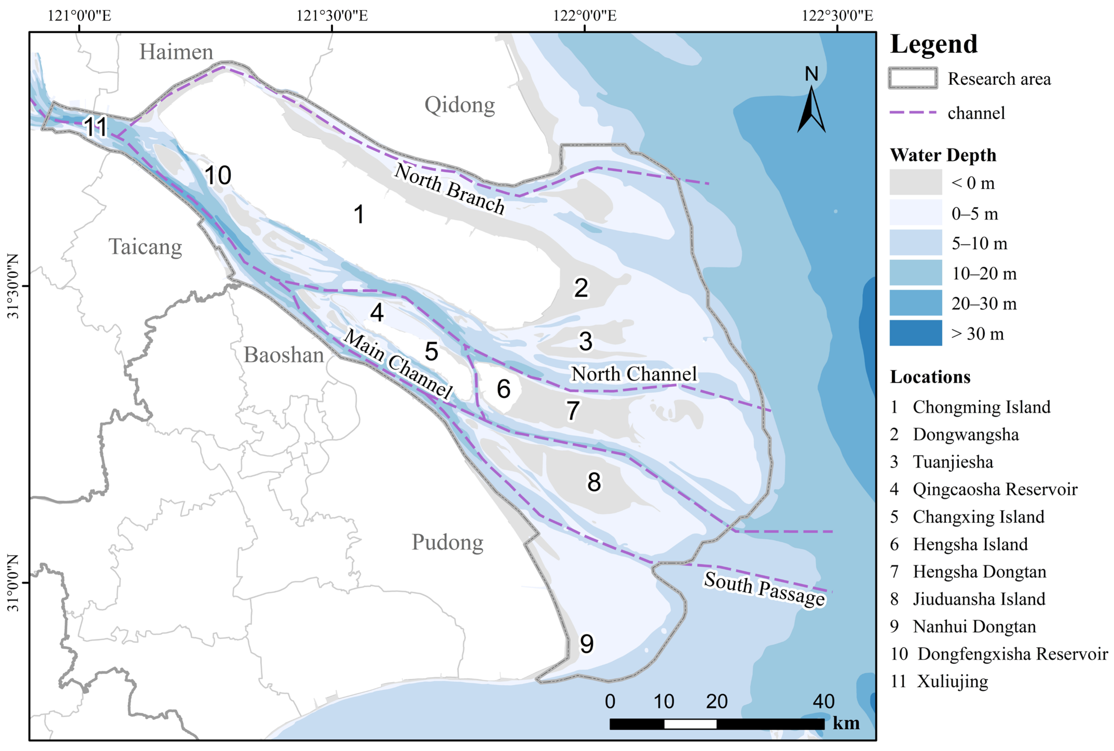
Figure 1. Research area.
Water 17 03002 g001
Figure 2. Conceptual model of adaptive management cycle.
Water 17 03002 g002
Figure 3. The comprehensive framework for the spatial planning of Estuary National Parks by applying an AM-oriented.
Water 17 03002 g003
Figure 4. Evaluation results of the YRE National Park in terms of (A) National representation, (B) Ecological importance, (C) Management feasibility, and (D) Establishment suitability.
Water 17 03002 g004
Figure 5. Suggested boundary and zoning of the YRE National Park in terms of (A) Management zones, (B) Functional zones.
Water 17 03002 g005
Figure 6. Seasonal control management scheme zoning in the YRE National Park.
Water 17 03002 g006
Figure 7. Map of overlay analysis national park planning and average annual shipping density for the last five years (2018–2023).
Water 17 03002 g007
Table 1. Zoning areas and management aims in the YRE National Park.
Control ZonesFunctional ZonesManagement AimsFirst Phase CompletedSecond Phase
Completed
Area/km2Proportion/%Area/km2Proportion/%
Core protected zoneStrictly protected areaProtect the concentrated distribution areas of Chinese sturgeon, white-headed crane and other national key protected wild animals and plants and their habitats, as well as the integrity and authenticity of the national representative coastal mudflat wetland natural ecosystem at the estuary of the middle and lower reaches of the Yangtze River.380.8457.32%795.9246.22%
General control zoneEcological conservation area *Control invasive alien species, such as Spartina alterniflora, and mitigate ecological risks, such as saltwater intrusion.--73.944.29%
41.76.28%258.1314.99%
Production and living areasCoordinate protection and development, maintain normal production and life under protection requirements, and promote green development transformation.209.8231.58%514.0529.85%
Science education and recreation areaProtect the scenery and ecological environment, provide diverse recreational opportunities such as natural experiences, ecotourism, leisure and wellness, and natural education opportunities30.734.63%75.424.38%
Service guarantee areaProvide necessary public services for visitors and provide a management system construction area for management departments.1.290.19%4.480.26%
Summary 664.38100%1721.94100%
Note: * The ecological conservation area spans across both the core protected zone and the general control zone.
Table 2. Seasonal zoning scheme and adaptive management strategies in the YRE National Park.
Seasonal ZoningSeasonal Control Management SchemeMonitoring Data and Other Sources of InformationFeedback and LearningAdaptive Management Strategies
Western
Chongming
According to the annual situation of young Chinese sturgeon entering the YRE (usually in May each year)- Real-time monitoring of juvenile Chinese sturgeon entry via acoustic telemetry and sonar systems
- Annual surveys of fish populations and health assessments
- Data from local fisheries and shipping traffic reports
-Annual review of management effectiveness based on sturgeon survival rates and population trends
- Adaptive adjustment of seasonal timing and restrictions based on monitoring outcomes and new research findings
Seasonal control zones prohibit fishing and impose mandatory speed restrictions on juvenile fish during the fattening period at the YRE; During no seasonal control seasons, the area can engage in normal production activities such as shipping and fishing;
Chongming DongtanFrom June to August, until the Chinese sturgeon enters the sea for fattening- Real-time monitoring of juvenile Chinese sturgeon entry via acoustic telemetry and sonar systems
- Continuous environmental DNA (eDNA) sampling and automated underwater video surveillance
- Collaboration with maritime authorities for ship movement data
- Quarterly workshops with stakeholders to evaluate disturbance levels and compliance
-Iterative refinement of communication protocols and speed regulations based on feedback and observed impacts
Real-time monitoring and recording of the entry of juvenile Chinese sturgeon into the YRE; during seasonal control, release dynamic information to ship management and public, requiring ships to avoid or reduce speed and prohibit honking
QidongFrom June to September, the summer migration season for migratory birds- Bird population counts and behavioral observations via drones and camera traps
- Environmental data (e.g., water quality, prey availability)
- Reports from community volunteers and patrol teams
- Seasonal debriefs with conservationists and local communities to assess bird responses and human compliance
- Revise prohibited activities and monitoring techniques annually based on ecological and social feedback
Prohibit fishing, play, and photography in sandpiper habitats; increase monitoring with drones and infrared cameras; strengthen patrols to ensure control measures
Jiuduanshan IslandFrom June to September, the summer migration season for migratory birds- Baseline biodiversity surveys and ecosystem health indicators
- Ongoing research on key species and habitat use patterns
- Stakeholder input from scientific committees and local experts
- Establish a framework for iterative strategy development as data becomes available
- Regular interdisciplinary reviews to integrate new information and adapt management goals
Under development: potential strategies include seasonal access restrictions, habitat restoration, and species-specific protections
Disclaimer/Publisher’s Note: The statements, opinions and data contained in all publications are solely those of the individual author(s) and contributor(s) and not of MDPI and/or the editor(s). MDPI and/or the editor(s) disclaim responsibility for any injury to people or property resulting from any ideas, methods, instructions or products referred to in the content.