
Enhancing Riverbank Protection along the Jamuna River, Bangladesh: Review of Previous Countermeasures and Morphological Assessment through Groyne-Based Solutions Using Numerical Modeling


Abstract
1. Introduction
2. Morphological Consequences of the Implemented Structures
2.1. Revetment Like Structures
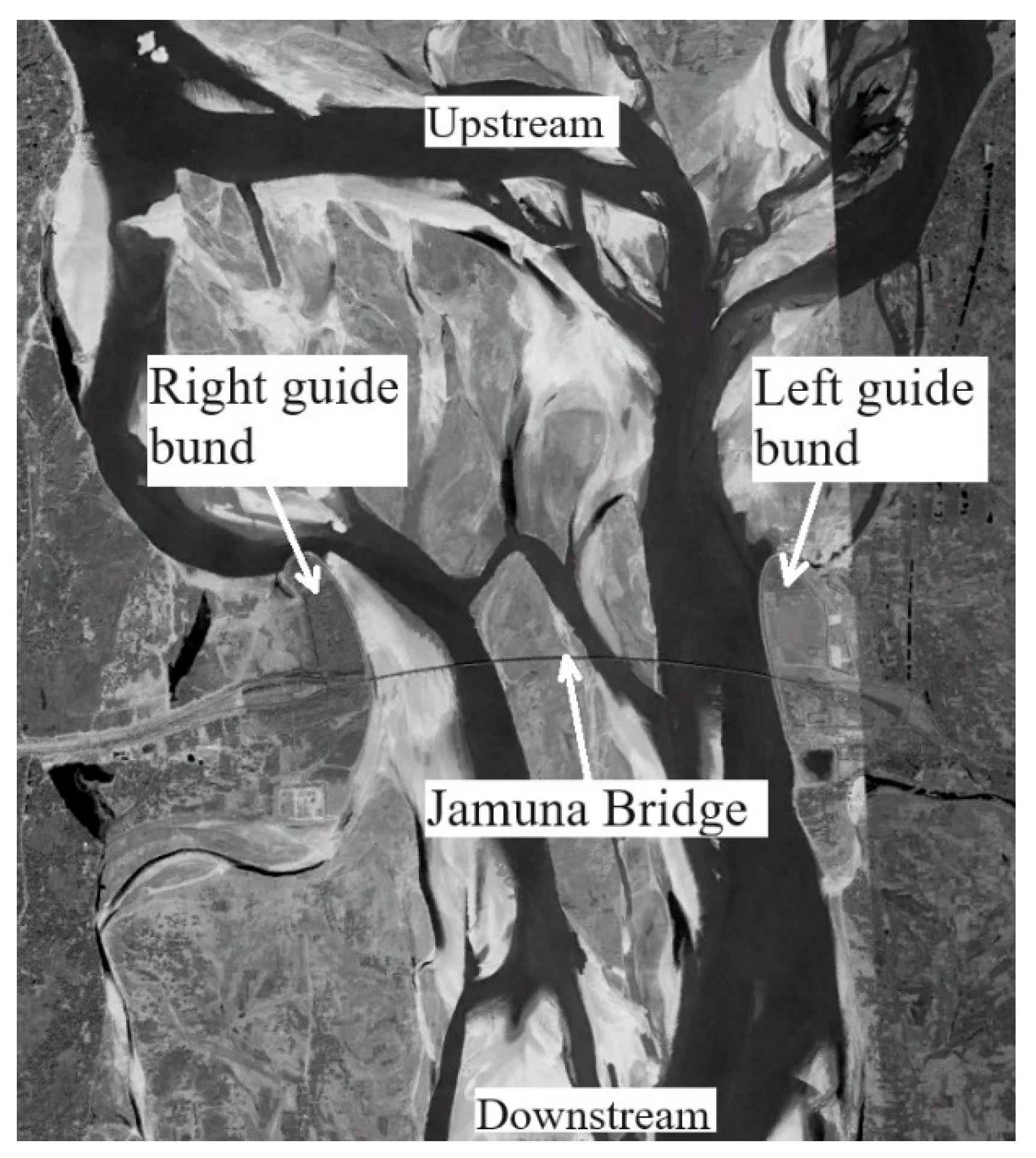
2.2. Guide Bunds
2.3. Groyne/Spur-like Structures
2.4. Evaluation of the Past Structures
3. Navigating River Dynamics: Methodology, Modeling, and Strategic Interventions
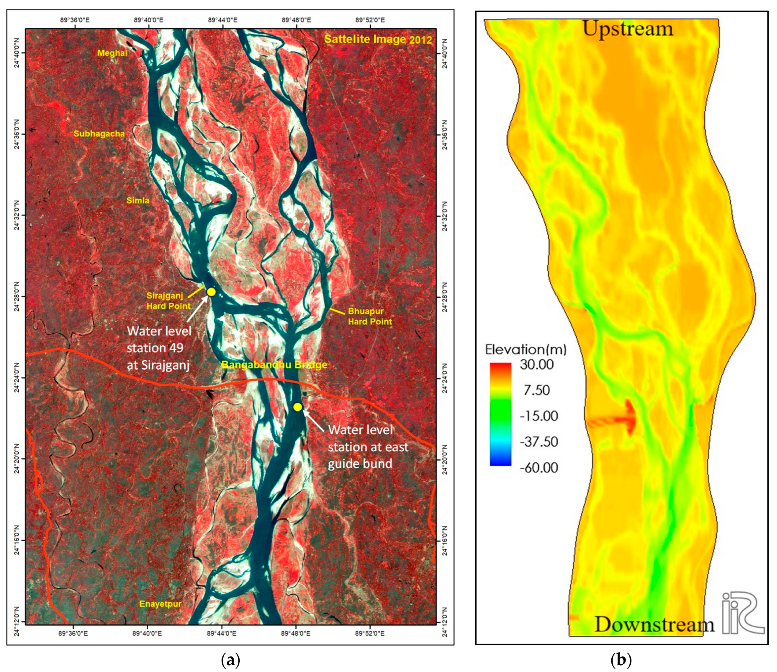
3.1. Data Collection
3.2. Model Setup
3.3. Model Calibration and Verification
3.4. Options for New Countermeasures
4. Results and Discussion
4.1. Evaluation of Two-Dimensional Morphological Aspects in Simulation Options
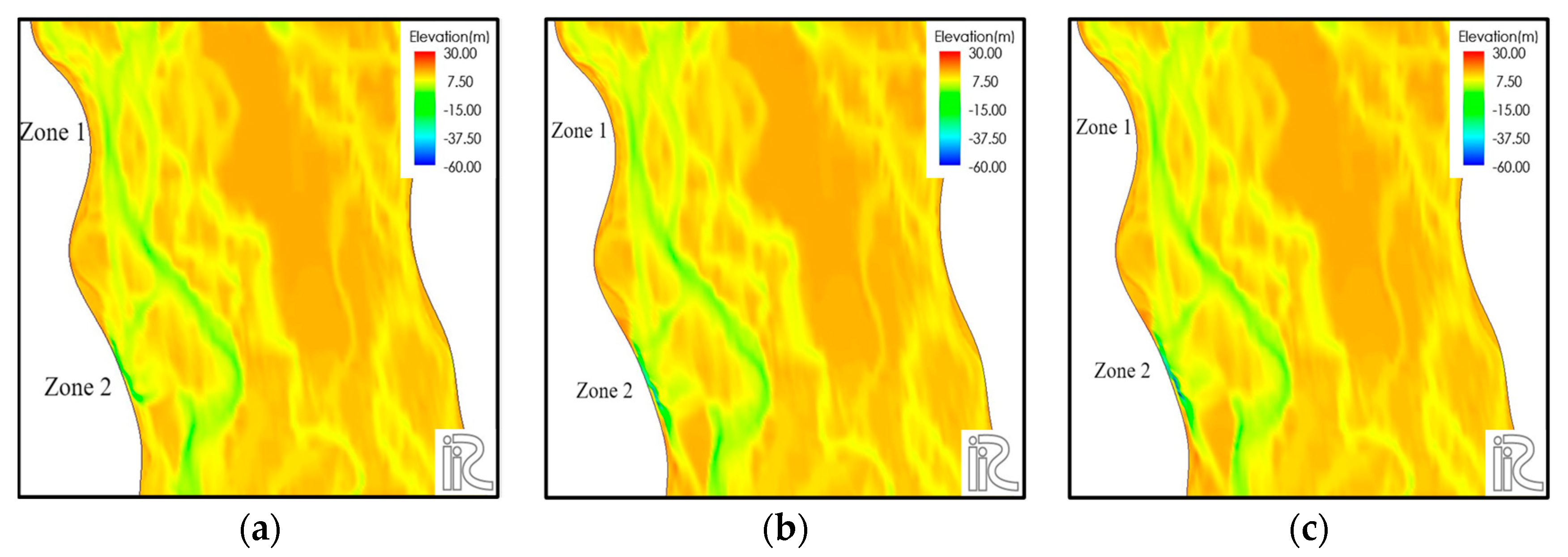
4.1.1. Morphological Assessment for Case_0
4.1.2. Morphological Assessment for Case_1
4.1.3. Morphological Assessment for Case_2
4.1.4. Morphological Assessment for Case_3
4.2. Comparisons of Mean Bed Elevations for the New Countermeasures
4.3. Review and Analysis of Results across All Simulation Cases
5. Conclusions
Author Contributions
Funding
Data Availability Statement
Acknowledgments
Conflicts of Interest
References
- Xu, J. Evolution of Mid-Channel Bars in a Braided River and Complex Response to Reservoir Construction: An Example from the Middle Hanjiang River, China. Earth Surf. Process. Landf. 1997, 22, 953–965. [Google Scholar]
- Williams, R.D.; Rennie, C.D.; Brasington, J.; Hicks, D.M.; Vericat, D. Linking the spatial distribution of bed load transport to morphological change during high-flow. J. Geophys. Res. Earth Surf. 2015, 120, 604–622. [Google Scholar] [CrossRef]
- Omar, P.J.; Rai, S.P.; Tiwari, H. Study of morphological changes and socio economic impact assessment: A case study of Koshi River. Arab. J. Geosci. 2022, 15, 1426. [Google Scholar] [CrossRef]
- Baki, A.B.M.; Gan, T.Y. Riverbank migration and island dynamics of the braided Jamuna River of the Gangesebrahmaputra basin using multi-temporal Landsat images. Quat. Int. 2012, 263, 148–161. [Google Scholar] [CrossRef]
- Marra, W.A.; Kleinhans, M.G.; Addink, E.A. Network concepts to describe channel importance and change in multichannel systems: Test results for the Jamuna River, Bangladesh. Earth Surf. Process. Landf. 2014, 39, 766–778. [Google Scholar] [CrossRef]
- Sarker, M.H.; Thorne, C.R.; Aktar, M.N.; Ferdous, M.R. Morpho-dynamics of the Brahmaputra–Jamuna River, Bangladesh. Geomorphology 2014, 215, 45–59. [Google Scholar] [CrossRef]
- Khan, N.I.; Islam, A. Quantification of erosion patterns in the Brahmaputra-Jamuna River using geographical information system and remote sensing techniques. Hydrol. Process. 2003, 17, 959–966. [Google Scholar] [CrossRef]
- Khan, I.; Ahammad, M.; Sarker, S. A study on River Bank Erosion of Jamuna River using GIS and Remote Sensing Technology. Int. J. Eng. Dev. Res. 2014, 2, 3365–3371. [Google Scholar]
- Saker, M.H.; Akter, J.; Ferdaous, M.R. River bank protection measures in the Brahmaputra-Jamuna River: Bangladesh Experience. In Proceedings of the International Seminar on River, Society and Sustainable Development, Dibrugarh, India, 26–29 May 2011. [Google Scholar]
- Rahman, M.M.; Kamal, M.A.H.M.; Rahman, M.M. Functioning Hydraulic and Morphological Sustainability of River Training Works in Bangladesh. J. Civ. Eng. Archit. 2013, 7, 756–766. [Google Scholar]
- Khan, N.S.; Roy, S.K.; Mazumder, M.T.R.; Talukdar, S.; Mallick, J. Assessing the long-term planform dynamics of Ganges–Jamuna confuence with the aid of remote sensing and GIS. Nat. Hazards 2022, 114, 883–906. [Google Scholar] [CrossRef]
- Uddin, M.J.; Jujuly, M.M.; Hossain, M.M.; Rahman, D.A. Applicability of Reinforced Concrete Spurs in River Bank Protection: A Case Study in Bangladesh. In Proceedings of the International Multidisciplinary Scientific GeoConference SGEM, Albena, Bulgaria, 18–24 June 2011. [Google Scholar]
- Rahman, S.; Lasker, M.S.; Islam, M.N. River Training Program and Hydro Morphological Dynamics: A Case Study of Bangabandhu Bridge at Jamuna River. Jahangirnagar Rev. Part II Soc. Sci. 2018, 42, 183–195. [Google Scholar]
- Wal, M.V.D. Bank Protection Structures along the Brahmaputra-Jamuna River, a Study of Flow Slides. Water 2020, 12, 2588. [Google Scholar]
- Zhang, H.; Nakagawa, H.; Baba, Y.; Kawaike, K.; Rahman, M.M.; Uddin, M.N. Hydraulic and Morphological Consequences of Bank protection Measures along the Jamuna River, Bangladesh. Annu. Disater. Prev. Res. Inst. Kyoto Univ. 2011, 54, 477–496. [Google Scholar]
- Nakagawa, H.; Zhang, H.; Baba, Y.; Kawaike, K.; Teraguchi, H. Hydraulic characteristics of typical bank-protection works along the Brahmaputra/Jamuna River, Bangladesh. J. Flood Risk Manag. 2013, 6, 345–359. [Google Scholar] [CrossRef]
- iRIC Software. Available online: https://i-ric.org/en/about/ (accessed on 27 September 2023).
- Inoue, T.; Mishra, J.; Kato, K.; Sumner, T.; Shimizu, Y. Supplied Sediment Tracking for Bridge Collapse with Large-Scale Channel Migration. Water 2020, 12, 7. [Google Scholar] [CrossRef]
- Dai, H.; Iwasaki, T.; Shimizu, Y. Effect of Sediment Supply on Morphodynamics of Free Alternate Bars: Insights from Hydrograph Boundary Layer. Water 2021, 13, 23. [Google Scholar] [CrossRef]
- Hasan, M.Z.; Toda, Y. Evaluation of Groynes Installation at the Vulnerable Bank of a Braided River. J. Hydraul. Eng. (JSCE) 2024, 80. in press. [Google Scholar]
- Ashworth, P.J.; Best, J.L.; Roden, J.; Bristow, C.S.; Klaassen, G.J. Morphological evolution and dynamics of a large, sandbraid-bar, Jamuna River, Bangladesh. Sedimentology 2000, 47, 533–555. [Google Scholar] [CrossRef]
- Laz, O.U.; Navera, U.K. Application of Delft3D Mathematical Model in the Jamuna River for Two-Dimensional Simulation. In Proceedings of the 4th International Conference on Civil Engineering for Sustainable Development, Khulna, Bangladesh, 25–27 December 2018. [Google Scholar]
- Musfequzzaman, M. Study of Hydro-Morphological Impact of Dredging in Selected Reach of the River Jamuna Using Two-Dimensional Morphological Model. Master’s Thesis, Bangladesh University of Engineering and Technology, Dhaka, Bangladesh, 2012. [Google Scholar]
- Haque, A.; Matin, M.A. A Study of Bank Line Shifting of the Selected Reach of Jamuna River Using Multi-Variant Regression Model. J. Soft Comput. Civ. Eng. 2022, 6, 21–33. [Google Scholar]
- Zin Zin, N.C.; Kazama, S.; Hagiwara, T. Morphological Changes due to the Peak Flow and Seasonal Flow of the Babame River. J. JSCE Ser. G (Environ. Res.) 2021, 77, 85–91. [Google Scholar] [CrossRef] [PubMed]
- Uddin, M.N.; Rahman, M.M. Flow and erosion at a bend in the braided Jamuna River. Int. J. Sediment Res. 2012, 27, 498–509. [Google Scholar] [CrossRef]
- Shampa; Hasegawa, Y.; Nakagawa, H.; Takebayashi, H.; Kawaike, K. Dynamics of Sand Bars in a Braided River: A Case Study of Brahmaputra-Jamuna River. Nat. Disaster Sci. J. JSNDS 2017, 36, 123–137. [Google Scholar]
- Rahman, M.M.; Hasan, M.S.; Eusufzai, M.K.; Rahman, M.M. Impacts of Dredging on Fluvial Geomorphology in the Jamuna River, Bangladesh. J. Geosci. Environ. Prot. 2021, 9, 1–20. [Google Scholar] [CrossRef]
- Shampa; Ali, M.M. Interaction between the braided bar and adjacent channel during flood: A case study of a sand-bed braided river, Brahmaputra–Jamuna. Sustain. Water Resour. Manag. 2019, 5, 947–960. [Google Scholar] [CrossRef]
- Hongshi, X.; Kui, X.; Wang, T.; Wanjie, X. Investigating Flood Risks of Rainfall and Storm Tides Affected by the Parameter Estimation Coupling Bivariate Statistics and Hydrodynamic Models in the Coastal City. Int. J. Environ. Res. Public Health 2022, 19, 19. [Google Scholar]
- Hasan, M.Z. Assessment of Hydro-Morphological Response of Selected Reach of the Jamuna River due to Structural Intervention Using Delft3D Model. Master’s Thesis, Bangladesh University of Engineering and Technology, Dhaka, Bangladesh, 2018. [Google Scholar]
- Alauddin, M. Morphological Stabilization of Lowland Rivers by Using a Series of Groynes. Ph.D. Thesis, Nagoya University, Nagoya, Japan, 2011. [Google Scholar]


| Cases | Run No. | No. of Groynes | Zone | Return Period (Years) | Discharge (m3/s) |
|---|---|---|---|---|---|
| Case_0 | Run 1 | - | - | 2.33 | 70,309 |
| Run 2 | - | - | 100 | 117,941 | |
| Run 3 | - | - | 200 | 126,180 | |
| Case_1 | Run 4 | 2 | 1 | 2.33 | 70,309 |
| Run 5 | 2 | 1 | 100 | 117,941 | |
| Run 6 | 2 | 1 | 200 | 126,180 | |
| Case_2 | Run 7 | 2 | 2 | 2.33 | 70,309 |
| Run 8 | 2 | 2 | 100 | 117,941 | |
| Run 9 | 2 | 2 | 200 | 126,180 | |
| Case_3 | Run 10 | 2 + 2 | 1, 2 | 2.33 | 70,309 |
| Run 11 | 2 + 2 | 1, 2 | 100 | 117,941 | |
| Run 12 | 2 + 2 | 1, 2 | 200 | 126,180 |
Disclaimer/Publisher’s Note: The statements, opinions and data contained in all publications are solely those of the individual author(s) and contributor(s) and not of MDPI and/or the editor(s). MDPI and/or the editor(s) disclaim responsibility for any injury to people or property resulting from any ideas, methods, instructions or products referred to in the content. |
© 2024 by the authors. Licensee MDPI, Basel, Switzerland. This article is an open access article distributed under the terms and conditions of the Creative Commons Attribution (CC BY) license (https://creativecommons.org/licenses/by/4.0/).
Share and Cite
Hasan, M.Z.; Toda, Y. Enhancing Riverbank Protection along the Jamuna River, Bangladesh: Review of Previous Countermeasures and Morphological Assessment through Groyne-Based Solutions Using Numerical Modeling. Water 2024, 16, 297. https://doi.org/10.3390/w16020297
Hasan MZ, Toda Y. Enhancing Riverbank Protection along the Jamuna River, Bangladesh: Review of Previous Countermeasures and Morphological Assessment through Groyne-Based Solutions Using Numerical Modeling. Water. 2024; 16(2):297. https://doi.org/10.3390/w16020297
Chicago/Turabian StyleHasan, Md. Zakir, and Yuji Toda. 2024. "Enhancing Riverbank Protection along the Jamuna River, Bangladesh: Review of Previous Countermeasures and Morphological Assessment through Groyne-Based Solutions Using Numerical Modeling" Water 16, no. 2: 297. https://doi.org/10.3390/w16020297
APA StyleHasan, M. Z., & Toda, Y. (2024). Enhancing Riverbank Protection along the Jamuna River, Bangladesh: Review of Previous Countermeasures and Morphological Assessment through Groyne-Based Solutions Using Numerical Modeling. Water, 16(2), 297. https://doi.org/10.3390/w16020297