

Mapping of Soil Erosion Vulnerability in Wadi Bin Abdullah, Saudi Arabia through RUSLE and Remote Sensing


Abstract
1. Introduction
Study Area
2. Materials and Methods
2.1. Data Sources
2.2. Morphometric Analysis
2.3. RUSLE Model
- A represents the annual average soil loss (t ha−1 yr−1);
- R is the rainfall erosivity factor (Mj mm ha−1 h−1 yr−1);
- K is the soil erodibility factor (t h Mj−1 mm−1);
- LS indicates the slope length and gradient factor (dimensionless);
- C is the land management factor (dimensionless).
2.3.1. Rainfall Erosivity (R)
2.3.2. Soil Erodibility Factor (K)
- San, sil, and cla are % sand, silt, and clay, respectively.
- C: organic carbon content.
- SN1: sand content subtracted from 1 and divided by 100 [38].
2.3.3. Topographic Factor (LS)
2.3.4. Land Cover Management Factor (C)
2.3.5. Conservation Practice Factor (P)
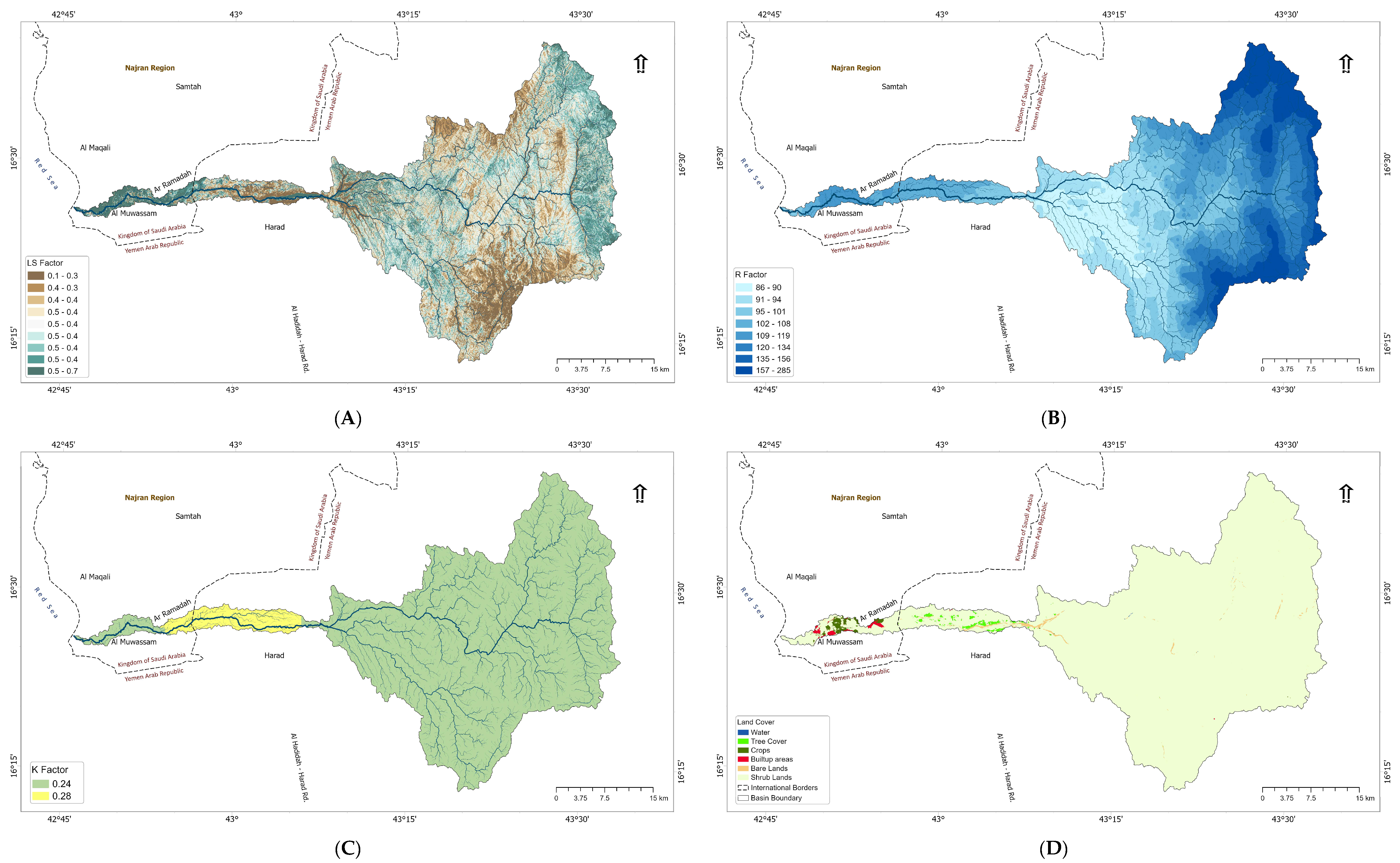
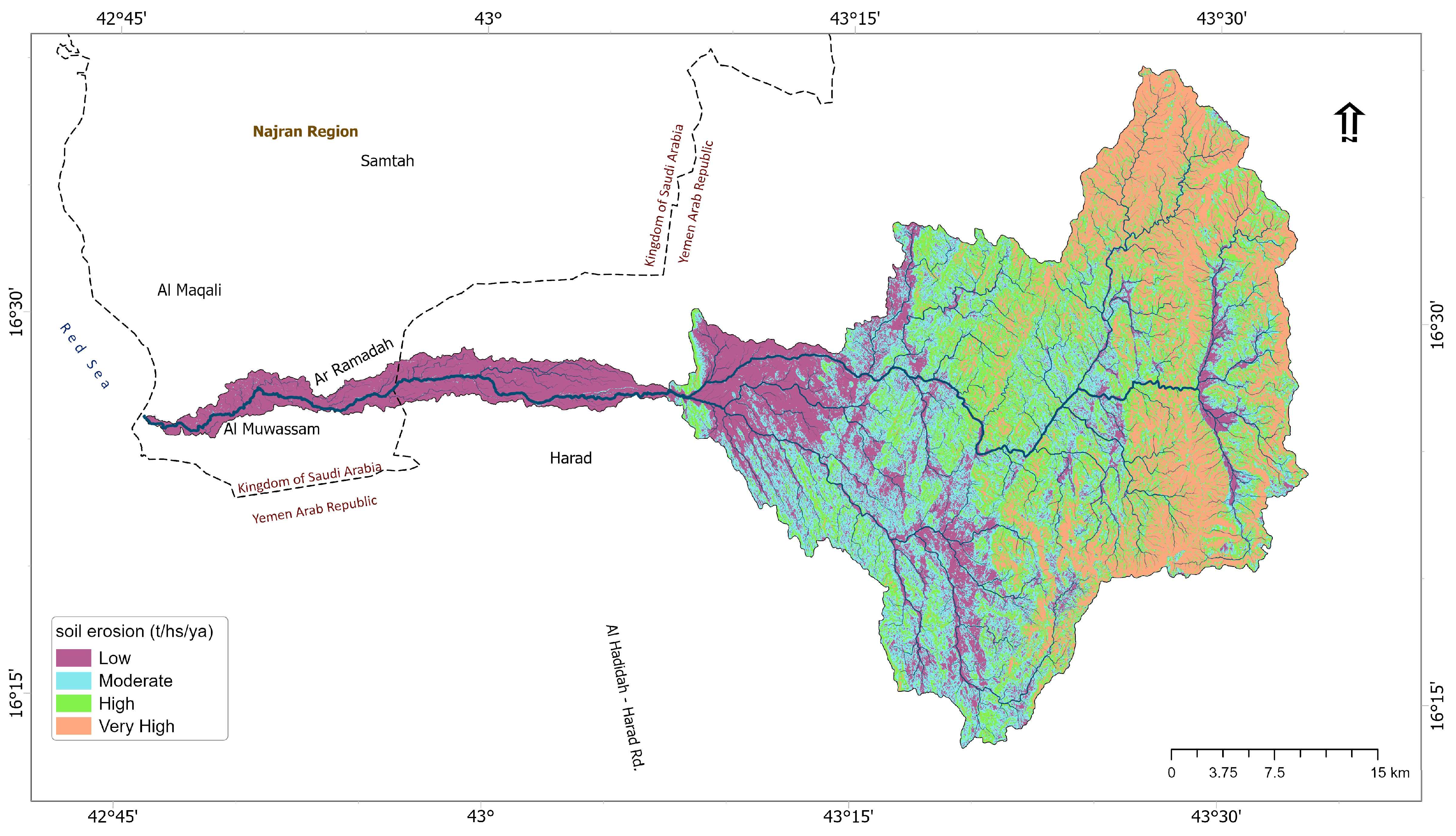
3. Results
3.1. RUSLE Model Parameters
3.1.1. R Factor
3.1.2. K Factor
3.1.3. Land Cover and Land Use
3.1.4. Cumulative Soil Loss Retention within the Basin
4. Discussion
5. Conclusions
Author Contributions
Funding
Data Availability Statement
Acknowledgments
Conflicts of Interest
References
- Kumar, S.; Mishra, A.; Singh, U.K. Assessment of Land Cover Changes and Climate Variability Effects on Catchment Hydrology Using a Physically Distributed Model. Sustainability 2023, 15, 304. [Google Scholar] [CrossRef]
- Kandekar, V.U.; Pande, C.B.; Rajesh, J.; Atre, A.A.; Gorantiwar, S.D.; Kadam, S.A.; Gavit, B. Surface Water Dynamics Analysis Based on Sentinel Imagery and Google Earth Engine Platform: A Case Study of Jayakwadi Dam. Sustain. Water Resour. Manag. 2021, 7, 44. [Google Scholar] [CrossRef]
- Panagos, P.; Borrelli, P.; Matthews, F.; Liakos, L.; Bezak, N.; Diodato, N.; Ballabio, C. Global Rainfall Erosivity Projections for 2050 and 2070. J. Hydrol. 2022, 610, 127865. [Google Scholar] [CrossRef]
- Wuepper, D. Countries and the Global Rate of Soil Erosion. Nat. Sustain. 2020, 3, 51–55. [Google Scholar] [CrossRef]
- Colman, C.B.; Oliveira, P.T.S.; Almagro, A.; Soares-filho, B.S.; Rodrigues, D.B.B. Effects of Climate and Land-Cover Changes on Soil Erosion in Brazilian Pantanal. Sustainability 2019, 11, 7053. [Google Scholar] [CrossRef]
- Panagos, P.; Ballabio, C.; Poesen, J.; Lugato, E.; Scarpa, S.; Montanarella, L.; Borrelli, P. A Soil Erosion Indicator for Supporting Agricultural, Environmental and Climate Policies in the European Union. Remote Sens. 2020, 12, 1365. [Google Scholar] [CrossRef]
- Betrie, G.D.; Mohamed, Y.A.; Van Griensven, A.; Srinivasan, R. Sediment Management Modelling in the Blue Nile Basin Using SWAT Model. Hydrol. Earth Syst. Sci. 2011, 15, 807–818. [Google Scholar] [CrossRef]
- Pimentel, D. Soil Erosion: A Food and Environmental Threat. Environ. Dev. Sustain. 2006, 8, 119–137. [Google Scholar] [CrossRef]
- Waseem, M.; Iqbal, F.; Humayun, M.; Umais Latif, M.; Javed, T.; Kebede Leta, M. Spatial Assessment of Soil Erosion Risk Using RUSLE Embedded in GIS Environment: A Case Study of Jhelum River Watershed. Appl. Sci. 2023, 13, 3775. [Google Scholar] [CrossRef]
- Arabameri, A.; Yamani, M.; Pradhan, B.; Melesse, A.; Shirani, K.; Tien Bui, D. Novel Ensembles of COPRAS Multi-Criteria Decision-Making with Logistic Regression, Boosted Regression Tree, and Random Forest for Spatial Prediction of Gully Erosion Susceptibility. Sci. Total Environ. 2019, 688, 903–916. [Google Scholar] [CrossRef]
- Jing, T.; Fang, N.; Zeng, Y.; Huang, X.; Shi, Z. Catchment Properties Controlling Suspended Sediment Transport in Wind-Water Erosion Crisscross Region. J. Hydrol. Reg. Stud. 2022, 39, 100980. [Google Scholar] [CrossRef]
- Thapa, P. Spatial Estimation of Soil Erosion Using RUSLE Modeling: A Case Study of Dolakha District, Nepal. Environ. Syst. Res. 2020, 9, 15. [Google Scholar] [CrossRef]
- Senanayake, S.; Pradhan, B.; Huete, A.; Brennan, J. Assessing Soil Erosion Hazards Using Land-Use Change and Landslide Frequency Ratio Method: A Case Study of Sabaragamuwa Province, Sri Lanka. Remote Sens. 2020, 12, 1483. [Google Scholar] [CrossRef]
- Almouctar, M.A.S.; Wu, Y.; Zhao, F.; Dossou, J.F. Soil Erosion Assessment Using the Rusle Model and Geospatial Techniques (Remote Sensing and Gis) in South-Central Niger (Maradi Region). Water 2021, 13, 3511. [Google Scholar] [CrossRef]
- Singh, M.C.; Sur, K.; Al-Ansari, N.; Arya, P.K.; Verma, V.K.; Malik, A. GIS Integrated RUSLE Model-Based Soil Loss Estimation and Watershed Prioritization for Land and Water Conservation Aspects. Front. Environ. Sci. 2023, 11, 243. [Google Scholar] [CrossRef]
- Azaiez, N.; Alleoua, A.; Baazaoui, N.; Qhtani, N. Assessment of Soil Loss in the Mirabah Basin: An Overview of the Potential of Agricultural Terraces as Ancestral Practices (Saudi Arabia). Open J. Soil Sci. 2020, 10, 159–180. [Google Scholar] [CrossRef]
- Zandalinas, S.I.; Fritschi, F.B.; Mittler, R. Global Warming, Climate Change, and Environmental Pollution: Recipe for a Multifactorial Stress Combination Disaster. Trends Plant Sci. 2021, 26, 588–599. [Google Scholar] [CrossRef] [PubMed]
- Montgomery, D.R.; Matson, P.A. Soil Erosion and Agricultural Sustainability. Proc. Natl. Acad. Sci. USA 2007, 104, 13268–13272. [Google Scholar] [CrossRef]
- Igwe, P.U.; Onuigbo, A.A.; Chinedu, O.C.; Ezeaku, I.I.; Muoneke, M.M. Soil Erosion: A Review of Models and Applications. Int. J. Adv. Eng. Res. Sci. 2017, 4, 138–150. [Google Scholar] [CrossRef]
- Merritt, W.S.; Letcher, R.A.; Jakeman, A.J. A Review of Erosion and Sediment Transport Models. Environ. Model. Softw. 2003, 18, 761–799. [Google Scholar] [CrossRef]
- Islam Saikh, N.; Sarkar, D.; Saha, S.; Mondal, P. Application of Machine Learning Algorithms for Soil Erosion Susceptibility Estimation in Gumani River Basin, Eastern India. J. Geol. Soc. India 2024, 100, 320–334. [Google Scholar] [CrossRef]
- Horton, R. Drainage Basin Characteristics. Trans. Am. Geophys. Union 1932, 13, 350–361. [Google Scholar] [CrossRef]
- Langbein, W.B. Topographic Characteristics of Drainage Basins. U.S. Geol. Surv. Water-Supply Pap. 1947, 968-C, 125–157. [Google Scholar]
- Appolov, B.A. A Study of Rivers; Izdatel’stvo Moskovskogo Universiteta: Moscow, Russia, 1963. [Google Scholar]
- Schumm, S.A. Evolution of Drainage Systems and Slopes in Badlands at Perth Amboy, New Jersey. Bull. Geol. Soc. Am. 1956, 67, 597–646. [Google Scholar] [CrossRef]
- Strahler, N. Dimensional Analysis Applied to Fluvially Eroded Landforms. Geol. Soc. Am. Bull. 1958, 69, 279–300. [Google Scholar] [CrossRef]
- Pike, R.J.; Wilson, S.E. Elevation-Relief Ratio, Hypsometric Integral, and Geomorphic Area-Altitude Analysis. Geol. Soc. Am. Bull. 1971, 82, 1079–1084. [Google Scholar] [CrossRef]
- Miller, V.C. A Quantitative Geomorphic Study of Drainage Basin Characteristics in the Clinch Mountain Area, Virginia and Tennessee; Technical Report 3; Columbia University, Department of Geology: New York, NY, USA, 1953. [Google Scholar]
- Gravelius, H. Morphometry of Drainage Basins; Elsevier: Amsterdam, The Netherlands, 1914. [Google Scholar]
- Chorley, R.J.; Donald, M.; Pogrzelski, H. A New Standard for Estimating Drainage Basin Shape. Am. J. Sci. 1957, 255, 138–141. [Google Scholar] [CrossRef]
- Aparna, P.; Nigee, K.; Shimna, P.; Drissia, T.K. Quantitative Analysis of Geomorphology and Flow Pattern Analysis of Muvattupuzha River Basin Using Geographic Information System. Aquat. Procedia 2015, 4, 609–616. [Google Scholar] [CrossRef]
- Kabite, G.; Gessesse, B. Hydro-Geomorphological Characterization of Dhidhessa River Basin, Ethiopia. Int. Soil Water Conserv. Res. 2018, 6, 175–183. [Google Scholar] [CrossRef]
- Melton, M.A. Drainage Structure of Morphometric Properties of Systems and Their Controlling Agents. J. Geol. 1958, 66, 442–460. [Google Scholar] [CrossRef]
- Rastogi, R.A.; Sharma, T. Quantitative analysis of drainage basin characteristics. J. Soil Water Conserv. India 2022, 26, 18–25. [Google Scholar]
- Asfaw, D.; Workineh, G. International Soil and Water Conservation Research Quantitative Analysis of Morphometry on Ribb and Gumara Watersheds: Implications for Soil and Water Conservation. Int. Soil Water Conserv. Res. 2019, 7, 150–157. [Google Scholar] [CrossRef]
- Uddin, M.J.; Babu, M.A.H.; Islam, M.R.; Farzana, F.; Khatun, M.L.; Sazzad, S.M.F.; Islam, M.S. Estimation of Morphometric Parameters of Karatoya Sub-River Basin in Bangladesh Using GIS and Remote Sensing Techniques. Grassroots J. Nat. Resour. 2020, 3, 73–89. [Google Scholar] [CrossRef]
- Renard, K.G.; Foster, G.R.; Weesies, G.A.; Porter, J.P. RUSLE: Revised universal soil loss equation. J. Soil Water Conserv. 1991, 46, 30–33. [Google Scholar]
- Arnoldus, H.M.J. An Approximation of the Rainfall Factor in the Universal Soil Loss Equation. Assess. Eros. 1980, 6, 127–132. [Google Scholar]
- Erencin, Z. C-Factor Mapping Using Remote Sensing and GIS; A Case Study of Lom Sak/Lom Kao, Thailand; International Institute for Aerospace Survey and Earth Sciences (ITC): Upper Aise, The Netherlands, 2000. [Google Scholar]
- Kouli, M.; Soupios, P. Soil Erosion Prediction Using the Revised Universal Soil Loss Equation (RUSLE) in a GIS Framework, Chania, Northwestern Crete, Greece. Environ. Geol. 2008, 57, 483–497. [Google Scholar] [CrossRef]
- Li, P.; Tariq, A.; Li, Q.; Ghaffar, B.; Farhan, M.; Jamil, A.; Soufan, W.; El Sabagh, A.; Freeshah, M. Soil Erosion Assessment by RUSLE Model Using Remote Sensing and GIS in an Arid Zone. Int. J. Digit. Earth 2023, 16, 3105–3124. [Google Scholar] [CrossRef]
- Wischmeier, W.H.; Smith, D.D. Predicting Rainfall Erosion Losses: A Guide to Conservation Planning; Agricultural Handbook No. 537.; U.S. Department of Agriculture: Washington, DC, USA, 1978. [Google Scholar]
- Maqsoom, A.; Aslam, B.; Hassan, U.; Kazmi, Z.A.; Sodangi, M.; Tufail, R.F.; Farooq, D. Geospatial Assessment of Soil Erosion Intensity and Sediment Yield Using the Revised Universal Soil Loss Equation (RUSLE) Model. ISPRS Int. J. Geo-Inf. 2020, 9, 356. [Google Scholar] [CrossRef]
- Barbosa, W.C.d.S.; Guerra, A.J.T.; Valladares, G.S. Soil Erosion Modeling Using the Revised Universal Soil Loss Equation and a Geographic Information System in a Watershed in the Northeastern Brazilian Cerrado. Geosciences 2024, 14, 78. [Google Scholar] [CrossRef]


| Variable | Symbol | Source | |
|---|---|---|---|
| Basin relief | Mean elevation | H′ (m) | (Horton, 1932) [22] |
| Minimum elevation | h min (m) | WMS output | |
| Maximum elevation | H max (m) | WMS output | |
| Mean basin slope | I b (m/m) | (Horton, 1932) [22] | |
| Main channel slope | I s (m/m) | (Langbein, 1947) [23] | |
| Mean slope of water divide | I p (m/km) | (Appolov, 1963) [24] | |
| Basin perimeter | P (km) | (Schumm, 1956) [25] | |
| Total basin relief | Z-z (m) | (Strahler, 1952) [26] | |
| Hypsometric Integral | Hi (m/m) | (Pike et al., 1971) [27] | |
| Basin shape | Form factor ratio | Ff | Horton, 1932 [22] |
| Elongation ratio | Re | Schumm, 1956 [25] | |
| Circularity ratio | Rc | Miller, 1953 [28] | |
| Compactness coefficient | Cc | Gravelius, 1914 [29] | |
| Lemniscate factor | k | Chorley, 1957 [30] | |
| Stream Order (u) | Stream Number (Nu) | Stream Length (km) (Lu) | Mean stream Length (km) (Lu′) |
|---|---|---|---|
| 1 | 2341 | 1262.3 | 0.54 |
| 2 | 520 | 615.7 | 1.18 |
| 3 | 105 | 285.3 | 2.72 |
| 4 | 25 | 193.0 | 7.72 |
| 5 | 5 | 64.0 | 12.80 |
| 6 | 2 | 59.6 | 29.80 |
| 7 | 1 | 60.8 | 60.80 |
| Total | 2999 | 2540.8 | 0.85 |
| Morphometry Indicator | Value | |
|---|---|---|
| Stream frequency | Fs | 2.43 |
| Drainage density | Dd | 2.06 |
| Drainage intensity | Fs/Dd | 1.18 |
| Infiltration number | Fs*Dd | 5 |
| Overland flow | Fo | 1.03 |
| Mean bifurcation ratio | Rbm | 4.9 |
| Weighted bifurcation ratio | WRb | 4.3 |
| Stream slope | Ss | 1.89 |
| Constant of channel Maintenance | CCM | 0.49 |
| Morphometry Indicator | Value |
|---|---|
| Basin area (km2) | 1235 |
| Basin length (km) | 84.8 |
| Basin width (km) | 14.6 |
| Perimeter length (km) | 304 |
| Gradient (longest path) | 138.5 |
| Circulatory ratio (Rc) ratio (Rc) | 0.17 |
| Elongation ratio (Re) | 0.23 |
| Form factor (Ff) | 0.17 |
| Compactness coefficient (Cc) | 2.44 |
| Length/width ratio | 5.82 |
| Leminescate ratio | 1.46 |
| Months | Average Temperature (°C) | Relative Humidity (%) | Wind Speed km/h | Rainfall (mm) |
|---|---|---|---|---|
| January | 25.1 | 53.2 | 6 | 7.6 |
| February | 26.3 | 51.7 | 5.9 | 3.9 |
| March | 28.6 | 47.1 | 6 | 4.3 |
| April | 31 | 42.3 | 5.9 | 4.3 |
| May | 32.7 | 40 | 5.8 | 3.6 |
| June | 34 | 37.4 | 6 | 2.2 |
| July | 33.2 | 44 | 6.3 | 10.8 |
| August | 32.5 | 50.3 | 6.1 | 20.6 |
| September | 33.1 | 42.1 | 6.3 | 2.09 |
| October | 30.8 | 38 | 6.9 | 2.5 |
| November | 27.8 | 43.7 | 7.1 | 4.5 |
| December | 25.7 | 49.6 | 6.7 | 9.2 |
| Data | Spatial Resolution | Source |
|---|---|---|
| Digital Elevation Model (DEM) | 30 m | USGS |
| Climate Data | 30 pixel size | Global Rainfall Erosivity |
| Soil Data | 30 pixel size | HWSD Dataset |
| Land Cover Land Use | 10 m | Sentinal-2 Data |
| Basin relief | Basin area (km2) | A | Hierarchical rank |
| Basin length (km) | Lb | Obtained from ArcGIS Pro | |
| Basin width (km) | Wb | Obtained from ArcGIS Pro | |
| Perimeter length (km) | P | Obtained from ArcGIS Pro | |
| Maximum elevation (m) | H | Obtained from ArcGIS Pro | |
| Minimum elevation (m) | h | Obtained from ArcGIS Pro | |
| Mean elevation (m) | H’ | Obtained from ArcGIS Pro | |
| Main stream length (km) | L | Obtained from ArcGIS Pro | |
| Total stream length (km) | ΣLu | Obtained from ArcGIS Pro | |
| Hypsometric integral | Hi (m/m) | Hi (m/m) | |
| Basin form | Circulatory ratio (Rc) | Rc | Rc = 4π × A/P2 |
| Elongation ratio (Re) | Re | Re = (2/Lb) × 2√(A/π) | |
| Form factor (Ff) | Ff | Ff = A/Lb2 | |
| Compactness coefficient (Cc) | Cc | Cc = 0.2824 × p/√A | |
| Length/width ratio | Lb/Wb | Lb/Wb | |
| Lemniscate ratio | k | K = Lb2/A |
| Soil Unit | Sand % | Silt % | Clay % | Organic Carbon % | Soil Type | K Factor |
|---|---|---|---|---|---|---|
| 1 | 26 | 63 | 11 | 1.15 | Silty Loam | 0.24 |
| 1 | 37 | 46 | 17 | 3.14 | Loam | 0.28 |
Disclaimer/Publisher’s Note: The statements, opinions and data contained in all publications are solely those of the individual author(s) and contributor(s) and not of MDPI and/or the editor(s). MDPI and/or the editor(s) disclaim responsibility for any injury to people or property resulting from any ideas, methods, instructions or products referred to in the content. |
© 2024 by the authors. Licensee MDPI, Basel, Switzerland. This article is an open access article distributed under the terms and conditions of the Creative Commons Attribution (CC BY) license (https://creativecommons.org/licenses/by/4.0/).
Share and Cite
Alsaihani, M.; Alharbi, R. Mapping of Soil Erosion Vulnerability in Wadi Bin Abdullah, Saudi Arabia through RUSLE and Remote Sensing. Water 2024, 16, 2663. https://doi.org/10.3390/w16182663
Alsaihani M, Alharbi R. Mapping of Soil Erosion Vulnerability in Wadi Bin Abdullah, Saudi Arabia through RUSLE and Remote Sensing. Water. 2024; 16(18):2663. https://doi.org/10.3390/w16182663
Chicago/Turabian StyleAlsaihani, Majed, and Raied Alharbi. 2024. "Mapping of Soil Erosion Vulnerability in Wadi Bin Abdullah, Saudi Arabia through RUSLE and Remote Sensing" Water 16, no. 18: 2663. https://doi.org/10.3390/w16182663
APA StyleAlsaihani, M., & Alharbi, R. (2024). Mapping of Soil Erosion Vulnerability in Wadi Bin Abdullah, Saudi Arabia through RUSLE and Remote Sensing. Water, 16(18), 2663. https://doi.org/10.3390/w16182663