Irrigation of World Agricultural Lands: Evolution through the Millennia

 ,
,  ,
,
Abstract
1. Prolegomena
2. Pre-Historic Times
2.1. Initial Evidences from Early Mesopotamian and Chinese Civilizations. Assyrian, Phoenician, and Shang and Zhou Dynasties
2.2. Bronze Age Civilizations (ca 3200–1100 BC)
2.2.1. The Minoan Civilization of Crete
2.2.2. Indus Valley Civilizations (ca 3200–1300 BC)
2.2.3. Mesopotamian Civilizations
2.2.4. Others (Mediterranean and Middle Eastern Societies)
2.3. Early Ancient Egyptians (ca 3050–1550 BC up to 500 BC)
2.4. Early Pre-Columbian Time Civilizations in America (ca 2500 BC to 1540 AD)
3. Historical Times
3.1. Chinese Dynasties and Empires (ca 771 BC–581 AD): from the Spring and Autumn Period and the Warring States Period to the Northern and Southern Dynasties
3.2. Archaic, Classical, and Hellenistic Civilizations (ca 800–30 BC)
3.3. Roman Period (ca 30 BC–330 AD)
3.4. Other Historical Civilisations
3.4.1. Urartu Kingdom
3.4.2. The Levant and Beyond
4. The Sui, Tang, and Song Dynasties in China (581–1127 AD)
5. Late Pre-Columbian Civilizations
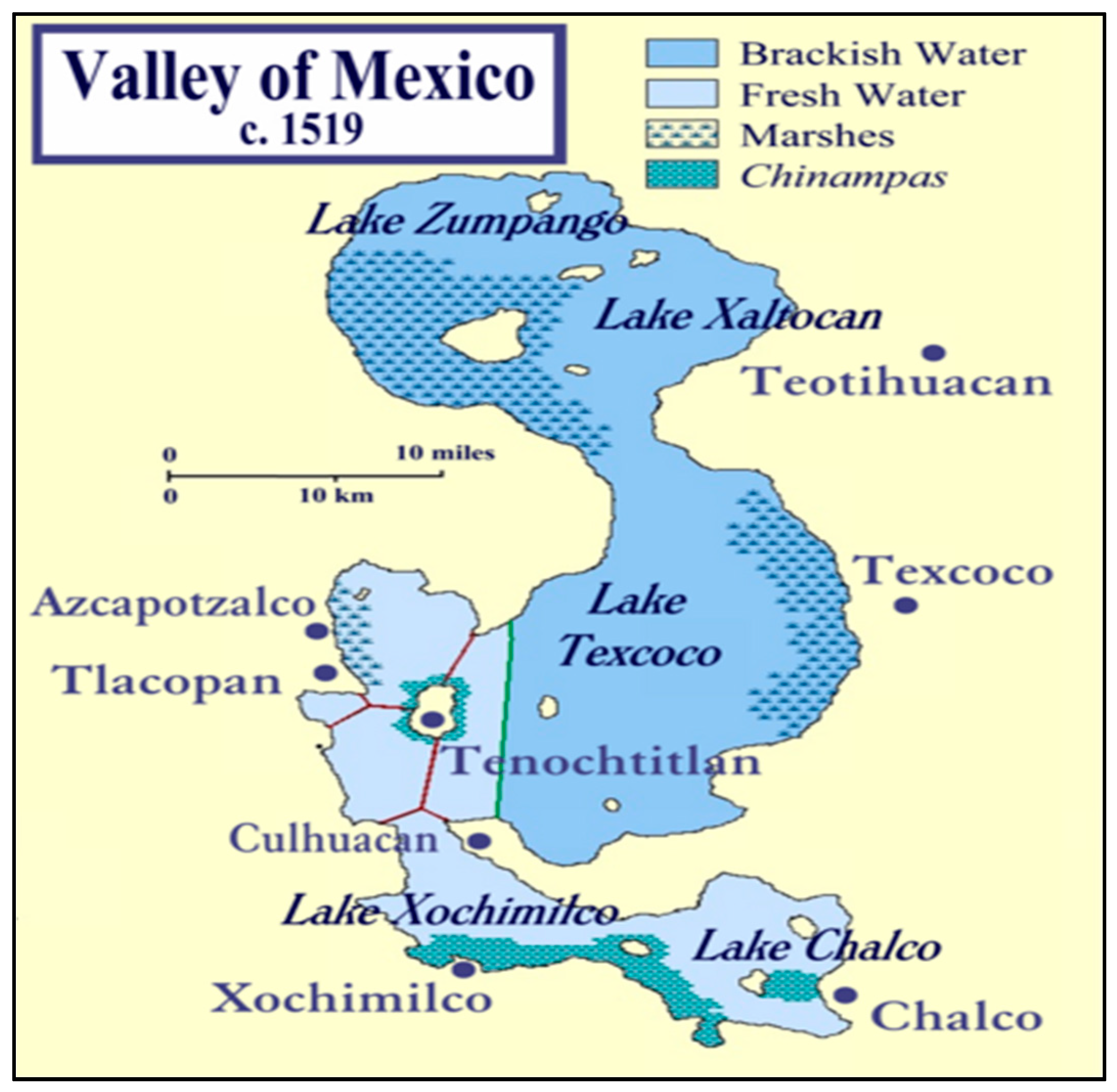
5.1. The Aztec Civilization and its Precursors (ca 1200–1500 AD)
5.2. The Inca Civilization (1438–1533 AD)
6. Medieval Times (ca 330–1500 AD)
6.1. The Byzantines and Other Civilizations (ca 330–1204 AD)
6.2. The Non-Arab Europe
7. Late Chinese Dynasties
8. Irrigation in Modern Times
8.1. The Ottoman Period (ca 16th Century–1923)
8.2. Irrigation Evolution in Present Times (1800 onward)
9. Main Agricultural Water Management Challenges and Future Trends
9.1. Present Day Challenges in Irrigated Agriculture
9.2. Future Directions Anticipated in Irrigated Agriculture
10. Epilogue
- water supply will be limited and regulated for all users, with water rights and water pricing schemes to be re-visited and adapted to changing conditions;
- larger quotas of water will be transferred from agriculture to urban areas, recreational activities and the environment;
- increased climatic variability will exacerbate problems of water supply and expose farmers to increasing vagaries and uncertainties;
- degradation of land and water resources may become more substantial and as well draw increasing public attention;
- more resource-efficient management practices will be needed at farm level that could also combine wider environmental benefits with economic gains for farmers;
- cropping systems implemented in irrigated agriculture in the arid and semiarid areas will need to adapt to less water availability and to lower-quality supplies;
- new varieties and cultivars of plants more adapted to drier conditions are and will be essential for a better use of water in agriculture; and
- the knowledge of the relationships of water and nutrients with the different types of soils will be also essential for proper agricultural water management.
Author Contributions
Funding
Acknowledgments
Conflicts of Interest
References
- Breasted, J.H. Ancient Times: A History of the Early World; The Athenaeum Press: Boston, MA, USA, 1916. [Google Scholar]
- Koutsoyiannis, D.; Angelakis, A.N. Agricultural Hydraulic Works in Ancient Hellas. In The Encyclopaedia of Water Science; Stewart, B.A., Howell, T., Eds.; Markel Dekker Inc.: New York, NY, USA, 2004; pp. 1–4. [Google Scholar]
- Sallares, R. The Ecology of the Ancient Greek World; Cornell University Press: New York, NY, USA, 1991. [Google Scholar]
- Lebesi, A. The Miniature House from Archanes; Archaiologiki Ephemeris: Athens, Greece, 1965; pp. 12–43. [Google Scholar]
- Angelakis, A.N.; De Feo, G.; Laureano, P.; Zourou, A. Minoan and Etruscan hydro-technologies. Water 2013, 5, 972–987. [Google Scholar] [CrossRef]
- Luthin, J.N. Drainage of Agricultural Lands; American Society of Agronomy: Madison, WI, USA, 1957. [Google Scholar]
- Krasilnikoff, J.A. Irrigation as innovation in ancient Greek agriculture. World Archaeol. 2010, 42, 108–121. [Google Scholar] [CrossRef]
- Bazza, M. Experience on Wastewater Reuse in the Near East; FAO Regional Office for the Near East: Cairo, Egypt, 2003. [Google Scholar]
- Bazza, M. Overview of the history of water resources and irrigation management in the Near East region. Water Sci. Technol. 2007, 7, 201–209. [Google Scholar] [CrossRef]
- Bazza, M. Overview of the history of water resources and irrigation management in the near east region. In Proceedings of the 1st IWA International Symposium on Water and Wastewater Technologies in Ancient Civilizations, Iraklion, Greece, 28–30 October 2006; pp. 593–604. [Google Scholar]
- Goblot, H. Dans L’ancien Iran: Les Techniques de L’eau et la Grande Histoire. Ann. Hist. Sci. Soc. 1963, 18, 499–520. [Google Scholar] [CrossRef]
- Water Encyclopedia. Available online: http://www.waterencyclopedia.com/Hy-La/Irrigation-Systems-Ancient.html (accessed on 30 December 2019).
- Viollet, P.L. L’hydraulique Dans les Civilisations Anciennes—5000 ans D’histoire; Presses de l’Ecole Nationale des Ponts et Chaussées: Paris, France, 2005; p. 374. [Google Scholar]
- Tamburrino, A. Water Technology in Ancient Mesopotamia. In Ancient Water Technologies; Mays, L.W., Ed.; Springer: New York, NY, USA, 2010; pp. 29–51. [Google Scholar]
- Xiuling, Y. Several views about unearthed rice and bone plough in the fourth cultural layer of Hemudu archaeological site. Archaeol. J. 1976, 8, 23–26. [Google Scholar]
- IA-CASS. Institute of Archaeology—Chinese Academy of Sciences. Zhongguo Kaoguxue Zhong Tanshisi Shujuji 1965–1991 (Radiocarbon Dating Data Set in Chinese Archaeology 1965–1991); Cultural Relies Publishing House: Beijing, China, 1991. [Google Scholar]
- Zhenglang, Z. Research on Technologies of Ancient Cultivation According to Oracles of Shang dynasty. Archaeol. J. 1973, 1, 97–124. [Google Scholar]
- Moody, J.; Grove, A.T. Terraces and Enclosure Walls in the Cretan Landscape. In Man’s Role in the Shape of the Eastern Mediterranean Landscape; Bottema, S., Balkema, A.A., Eds.; CRC Press: Boca Raton, FL, USA, 1990; pp. 183–191. [Google Scholar]
- Lyrintzis, A.; Angelakis, A.N. Is the Labyrinth a Water Catchment Technique? People and water management in Minoan Crete. In Proceedings of the 1st IWA International Symposium on Water and Wastewater Technologies in Ancient Civilizations, Iraklion, Greece, 28–30 October 2006; pp. 163–174. [Google Scholar]
- Angelakis, A.N.; Spyridakis, S.V. The status of water resources in Minoan times: A preliminary study. In Diachronic Climatic Impacts on Water Resources with Emphasis on Mediterranean Region; Angelakis, A.N., Issar, A.S., Eds.; Springer: Heidelberg, Germany, 1996; pp. 161–191. [Google Scholar]
- Angelakis, A.N.; Dialynas, M.G.; Despotakis, V. Evolution of Water Supply Technologies in Crete, Greece through the Centuries. In Evolution of Water Supply throughout Millennia; IWA Publishing: London, UK, 2012; pp. 227–258. [Google Scholar]
- Yannopoulos, S.; Lyberatos, G.; Theodosiou, N.; Li, W.; Valipour, M.; Tamburrino, A.; Angelakis, A.N. Evolution of Water lifting devices (pumps) through the centuries worldwide. Water 2015, 7, 5031–5060. [Google Scholar] [CrossRef]
- Water Management in Prehistoric Crete: The case of Choiromandres, Zakros. HYDRIA Project Collection, Storage & Distribution of Water in Antiquity Linking Ancient Wisdom to Modern Needs. Available online: http://www.hydriaproject.info/en/greece-crete-water-management-in-zakros-area/importance3 (accessed on 5 December 2019).
- Flood, J.M. Water Management in Neopalatial Crete and the Development of the Mediterranean Climate. Master’s Thesis, The University of North Carolina, Chapel Hill, NC, USA, 2012. [Google Scholar]
- Betancourt, P.P. The Dams and Water Management Systems of Minoan Pseira; INSTAP Academic Press: Philadelphia, PA, USA, 2012. [Google Scholar]
- Celka, S.M.; Puglisi, D.; Bendali, F. Settlement pattern dynamics and natural resources in MM-lM I Crete: The case of Malia. In Physis: ’Environnement Naturel Et La Relation Homme-Milieu Dans Le MONDE Égéen Protohistorique; Touchais, G., Laffineur, R., Rougemont, F., Eds.; Peeters, Leuven: Liege, Belgium, 2014. [Google Scholar]
- Betancourt, P.P.; Davaras, C.; Simpson, R.S. The Archaeological Survey of Pseira Island; INSTAP Academic Press: Philadelphia, PA, USA, 2004. [Google Scholar]
- Angelakis, A.N.; Spyridakis, S.V. Wastewater Management in Minoan Times. In Proceedings of the Meeting on Protection and Restoration of Environment, Chania, Greece, 28–30 August 1996; pp. 549–558. [Google Scholar]
- Wright, R.P.; Bryson, R.A.; Schuldenrein, J. Water supply and history: Harappa and the Beas regional survey. Antiquity 2008, 82, 37–48. [Google Scholar] [CrossRef]
- Lawler, A. Boring no more, a trade-savvy Indus emerges. Science 2008, 320, 1276–1281. [Google Scholar] [CrossRef]
- Violett, P.L. Water Engineering in Ancient Civilizations: 5000 Years of History; International Association of Hydraulic Engineering and Research (IAHR): Madrid, Spain, 2007. [Google Scholar]
- Kenoyer, M.J. Ancient Cities of the Indus Civilization; Oxford University Press: Oxford, UK, 1998; p. 260. [Google Scholar]
- Kenoyer, J.M. Urban Process in the Indus Tradition: A Preliminary Model from Harappa. In Harappa Excavations 1986–1990; Meadow, R.H., Ed.; Prehistory Press: Madison, WI, USA, 1991; pp. 29–60. [Google Scholar]
- Irrigation Development in India: History & Impact, Water Technology Centre, WTC, IARI, New Delhi. Available online: http://indiairrigation.blogspot.com/2009/01/history-of-irrigation-development-in_01.html (accessed on 30 December 2019).
- Krasilnikoff, J.; Angelakis, A.N. Water management and its judicial contexts in ancient Greece: A review from the earliest times to the Roman period. Water Policy 2019, 21, 245–258. [Google Scholar] [CrossRef]
- Harper, R.F. The Code of Hammurabi, King of Babylon, about 2250 BC (Translated); University of Chicago Press: Chicago, IL, USA, 1904. [Google Scholar]
- Richardson, M.E.J. Hammurabi’s Laws: Text, Translation, and Glossary; T&T Clark: London, UK, 2004. [Google Scholar]
- Shaw, B.D. Water and society in the Ancient Maghrib: Technology, property and development. Antiq. Afr. 1984, 20, 121–173. [Google Scholar] [CrossRef]
- El Amami, S.; Chaabouni, Z. Traditional Hydraulic Reshaping: A Means of Controlling Water Erosion; Research Center of Rural Engineering: Tunis, Tunisia, 1981. [Google Scholar]
- Criteria and Options for Appropriate Irrigation Methods. Available online: http://www.fao.org/3/W3094E/w3094e05.htm (accessed on 27 December 2019).
- Kees, H. Ancient Egypt: A Cultural Topography; University of Chicago Press: Chicago, IL, USA, 1961. [Google Scholar]
- Noaman, M.N.; El Quosy, D. Hydrology of the Nile and ancient agriculture. In Irrigated Agriculture in Egypt: Past, Present and Future; Satoh, M., Aboulroos, S., Eds.; Springer: Cham, Switzerland, 2017; Volume 2, pp. 9–28. [Google Scholar]
- Murray, G.W. A note on the Sadd el-Kafara: The ancient dam in wadi Garami. Bull. I’Institut d’Egvpte 1947, 28, 33–43. [Google Scholar]
- Garbrecht, G. The Sadd el Kafara, the world’s oldest dam. In Proceedings of the Special Session on History of Irrigation, 12th ICID Congress, Fort Collins, CO, USA, 28 May–2 June 1984. [Google Scholar]
- Joffe, G. Irrigation and Water Supply Systems in North Africa; Moroccan Studies: Casablanca, Morocco, 1992. [Google Scholar]
- Wikander, O. Sources of Energy and Exploitation of Power. In The Oxford Handbook of Engineering and Technology in the Classical World; Oleson, J.P., Ed.; Oxford University Press: Oxford, UK, 2008; pp. 136–157. [Google Scholar]
- Cohn, G.S. L’origine des Norias de Fès; Hespéris: Fez, Morocco, 1933; pp. 156–157. [Google Scholar]
- Angelfire. Available online: http://www.angelfire.com//journal/millbuilder/album5.html (accessed on 15 May 2018).
- Worldwatch. Available online: hrrp://www.worldwatch.org (accessed on 30 December 2019).
- Fedick, S. Land Evaluation and Ancient Maya Land Use in the Upper Belize. Lat. Am. Antiq. 1995, 6, 16–34. [Google Scholar] [CrossRef]
- Witschey, W.R.T. Encyclopedia of the Ancient Maya; Rowman & Littlefield Publishers: Lanham, MD, USA, 2015; p. 574. [Google Scholar]
- Scarborough, V.; Dunning, N.P.; Tankersley, K.B.; Carr, C.; Weaver, E.; Gracioso, L.; Sadurní, N. Diccionari de l’any 1000 a Catalunya; Edicions 62: Barcelona, Spain, 1999; p. 24. [Google Scholar]
- Doyle, J.A. Early Maya geometric planning conventions at El Palmar, Guatemala. J. Archaeol. Sci. 2013, 40, 793–798. [Google Scholar] [CrossRef]
- Lucero, L.I.; Joel, D.; Gunn, J.D.; Scarborough, V.L. Climate change and classic Maya management. Water 2011, 3, 479–494. [Google Scholar] [CrossRef]
- Scarborough, V.; Gallopin, G.G. A Water Storage Adaptation in the Maya Lowlands. Science 1991, 251, 658–662. [Google Scholar] [CrossRef]
- Largest Ancient Maya Dam Found in Guatemala. Available online: http://www.sci-news.com/archaeology/article00470.html (accessed on 30 December 2019).
- Isendalh, C. The Weight of Water: A New Look at Pre-hispanic Puuc Maya. Anc. Mesoam. 2011, 22, 185–197. [Google Scholar] [CrossRef]
- Pohl, M.D.; Pope, K.O.; Jones, J.G.; Jacob, J.S.; Piperno, D.R.; de France, S.D.; Lentz, D.S.; Gifford, J.A.; Danforth, M.E.; Josserand, J.K. Early Agriculutre in the Maya Lowlands. Lat. Am. Antiq. 1996, 7, 355–372. [Google Scholar] [CrossRef]
- Hodell, D.A.; Brenner, M.; Curtis, J.H.; Guilderson, T. Solar Forcing of Drought Frequency in the Maya Lowlands. Science 2001, 292, 1367–1370. [Google Scholar] [CrossRef]
- China Daily. Nanhu Lake. China Daily, 10 May 2010. [Google Scholar]
- Chi, C.T. Key Economic Areas in Chinese History; George Allenand Unwin: London, UK, 1936. [Google Scholar]
- Rackham, O. Ancient Landscapes. In The Greek City from Homer to Alexander; Murray, O., Price, S., Eds.; Oxford University Press: Oxford, UK, 1990; pp. 85–111. [Google Scholar]
- Amanatidis, G.T.; Paliatsos, A.G.; Repapis, C.C.; Bartzis, J.G. Decreasing precipitation trend in the Marathon area, Greece. Int. J. Climatol. 1993, 13, 191–201. [Google Scholar] [CrossRef]
- Krasilnikoff, J.A. Innovation in Ancient Greek Agriculture: Some Remarks on Climate and Irrigation. Class. Mediaev. 2014, 64, 95–116. [Google Scholar]
- Garnse-y, P. Famine and Food Supply in the Graeco-Roman World. Responses to Risk and Crisis; Cambridge University Press: Cambridge, UK, 1988. [Google Scholar]
- Glick, T.F. Irrigation and Society in Medieval Valencia; Cambridge Belknap Press of Harvard University Press: Cambridge, MA, USA, 1970. [Google Scholar]
- Crouch, D.P. Water Management in Ancient Greek Cities; Oxford University Press: Oxford, UK, 1993. [Google Scholar]
- Krasilnikoff, J.A. Water and farming in Classical Greece: Evidence, Method and Perspective. In Ancient History Matters: Studies Presented to Jens Erik Skydsgaard on His Seventieth Birthday; Ascani, V., Gabrielsen, K.K., Rasmussen, A.H., Eds.; L’Erma di Bretschneider: Rome, Italy, 2002; pp. 47–62. [Google Scholar]
- Carroll-Spilleche, M. Der Antike Griechische Garten: Wohnen in der Griechischen Polis III; Deutscher Kunstverlag: Munich, Germany, 1989. [Google Scholar]
- Osborne, R. Classical Greek Gardens: Between Farm and Paradise. In Garden History. Issues, Approaches, Methods. Dumbarton Oaks Colloquium on the History of Landscape Architecture XIII; Hunt, J.D., Ed.; Harvard University Press: Cambridge, MA, USA, 1992; pp. 373–391. [Google Scholar]
- Foxhall, L. Olive Cultivation in Ancient Greece: Seeking the Ancient Economy; Oxford University Press: Oxford, UK, 2007. [Google Scholar]
- Bowe, P. Civic and other public planting in ancient Greece. Stud. Hist. Gard. Des. Landsc. 2011, 31, 269–285. [Google Scholar] [CrossRef]
- Raaflaub, K.A. The Transformation of Athens in the Fifth Century. In Democracy, Empire, and the Arts in Fifth-Century Athens. Center for Hellenic Studies Colloquia 2; Boedeker, D., Raaflaub, K.A., Eds.; Harvard University Press: Cambridge, MA, USA, 1998; pp. 15–41. [Google Scholar]
- Austin, M.M. The Hellenistic World from Alexander to the Roman Conquest. A Selection of Ancient Sources in Translation; Cambridge University Press: Cambridge, UK, 1981. [Google Scholar]
- Knauss, J. Wasserbau und Siedlungsbedingungen im Altertum: Die Melioration des Kopaisbeckens durch die Minyer im 2. Jt. v. Chr. (Kopasis 2); Technische Universität München, Versuchsanstalt für Wasserbau und Wassermengenwirtschaft: Munich, Germany, 1987. [Google Scholar]
- Knauss, J.; Heinrich, B.; Kalcyk, H. Die Wasserbauten der Minyer in der Kopais–die älteste Flussregulerung Europas. Bericht Nr. 50; Institut für Wasserbau und Wassermengenwirtschaft und Versuchsanstalt für Wasserbau, Oskar v. Miller-Institut, Obernach Technische Universität München: Munich, Germany, 1984. [Google Scholar]
- Horden, P.; Purcell, N. The Corrupting Sea: A Study of Mediterranean History, 8th ed.; Wiley-Blackwell: Hoboken, NJ, USA, 2000; p. 776. [Google Scholar]
- Lohmann, H. Atene: Forschungen zu Siedlungs-und Wirtschaftsstruktur des klassischen Attika; Bohlau Verlag: Koln, Germany, 1993. [Google Scholar]
- Price, S.; Nixon, L. Ancient Greek Agricultural Terraces: Evidence from Texts and Archaeological Survey. Am. J. Archaeol. 2005, 109, 665–694. [Google Scholar] [CrossRef]
- Moreno, A. Feeding the Democracy. The Athenian Grain Supply in the Fifth and Fourth Centuries BC; Oxford University Press: Oxford, UK, 2007. [Google Scholar]
- Prieto, A. Landscape Organization in Magna Graecia. Ph.D. Thesis, University of Texas, Austin, TX, USA, 2005. [Google Scholar]
- Wilson, A. Land drainage. In Handbook of Ancient Water Technology. Technology and Change in History, Vol. 2; Wikander, Ö., Ed.; Brill: Leiden, Belgium, 2000; pp. 303–317. [Google Scholar]
- Margaritis, E.; Jones, M.K. Greek and Roman agriculture. In Handbook of Engineering and Technology in the Classical World; Oleson, G., Ed.; Oxford University Press: Oxford, UK, 2008; pp. 567–578. [Google Scholar]
- Cato, M.P.; Varro, M.T. On Agriculture; Harvard University Press: Cambridge, MA, USA, 1934. [Google Scholar]
- White, K.D. Roman Farming; Thames & Hudson: London, UK, 1970. [Google Scholar]
- Mays, L.W. A very brief History of Hydraulic Technology during Antiquity. Environ. Fluid Mech. 2008, 8, 471–484. [Google Scholar] [CrossRef]
- Butzer, K.W.; Mateu, J.F.; Butzer, E.; Kraus, P. Irrigation agrosystems in eastern Spain: Roman or Islamic origins? Ann. Assoc. Am. Geogr. 1985, 75, 479–509. [Google Scholar] [CrossRef]
- Lechtman, H.; Hobbs, L. Roman concrete and Roman architecture revolution. In High Technology Ceramics: Past, Present, and Future: The nature of Innovation and Change in Ceramic Technology; Kingery, W.D., Ed.; American Ceramic Society: Westerville, OH, UAS, 1986. [Google Scholar]
- Pounds, N.J.G. An Historical Geography of Europe 450 BC-AD 1330; Cambridge University Press: Cambridge, UK, 1973. [Google Scholar]
- Von Stackelberg, K.T. The Roman Garden: Space, Sense, and Society; Routledge: London, UK, 2009. [Google Scholar]
- Fentress, E.; Quilici Gigli, S. La Domesticazione delle Piante e L’agricoltura: Mondo Greco e Mondo Romano. Available online: http://www.treccani.it/enciclopedia/la-domesticazione-delle-piante-e-l-agricoltura-mondo-grecoe-mondo-romano_%28Il-Mondo-dell\T1\textquoterightArcheologia%29/ (accessed on 20 October 2015).
- Barker, G.; Gilbertson, D.; Jones, B.; Mattingly, D. Farming the Desert: The UNESCO Libyan Valleys Archaeological Survey; Graeme, B., Ed.; UNESCO/Department of Antiquities: Tripoli, Libya, 1996; Volume 1. [Google Scholar]
- Kamash, Z. Irrigation technology, society and environment in the Roman Near East. J. Arid Environ. 2012, 86, 65–74. [Google Scholar] [CrossRef]
- Smith, N.A. History of Dams; P. Davies: London, UK, 1971. [Google Scholar]
- Belli, O. Urartian Irrigation Canals in Eastern Anatolia; Archeology and Art Press: Istanbul, Turkey, 1997. [Google Scholar]
- Orhan, A.H. Urartian Water Constructions and Hydraulics; University of Yüzüncü Yıl: Tuşba, Van, Turkey, 2004. [Google Scholar]
- Çifçi, A.; Greaves, A.M. Urartian Irrigation Systems. Anc. Near East. Stud. 2013, 50, 191–214. [Google Scholar]
- Garbrecht, G. Historische Wasserbauten im Ost-Anatolien; DWhG: Siesburg, Germany, 2004. [Google Scholar]
- English, P.W. The origin and spread of qanats in the Old World. Proc. Am. Philos. Soc. 1968, 112, 170–181. [Google Scholar]
- English, P.W. Qanats and Lifeworlds in Iranian Plateau Villages. In Proceedings of the Conference on Transformation of Middle Eastern Natural Environment: Legacies and Lessons, New Haven, CT, USA, 28 October–1 November 1997. [Google Scholar]
- Miu, Q.Y. Research on History of Polders in the Taihu Lake Basin; Agricultural Press: Beijing, China, 1985. [Google Scholar]
- Wang, Z. Annotation of Agricultural Treatise; Shandong Publishing Group: Jinan, China, 1313. [Google Scholar]
- Plattner, G. Intergovernmental Panel on Climate Change. Climate Change 2014: Synthesis Report. Contribution of Working Groups I, II and III to the Fifth Assessment Report of the Intergovernmental Panel on Climate Change; IPCC: Geneva, Switzerland, 2014. [Google Scholar]
- Morehar, C.T. Mapping ancient chinampa landscapes in the Basin of Mexico: A remote sensing and GIS approach. J. Archeol. Sci. 2012, 39, 2541–2551. [Google Scholar] [CrossRef]
- Armillas, P. Gardens on swamps. Science 1971, 175, 653–661. [Google Scholar] [CrossRef]
- Smith, M. The Aztec Silent Majority: William T. Sanders and the Study of the Aztec Peasantry. In Arqueología Mesoamericana; Alba Guadalupe Mastache, A., Parsons, J.R., Santley, R.S., Serra Puche, M.C., Eds.; Instituto Nacional de Antropología e Historia: Mexico City, Mexico, 1996; Volume 1, pp. 375–386. [Google Scholar]
- McCaa, R. The Peopling of Mexico from Origins to Revolution. In The Population History of North America; Richard Steckel, R., Haines, M., Eds.; Cambridge University Press: Cambridge, UK, 2000; pp. 241–304. [Google Scholar]
- DGCOH Dirección General de Construcción y Operación Hidráulica. El Sistema del Drenaje Profundo de la Ciudad de México, 3rd ed.; Dirección General de Construcción y Operación Hidráulica, Dirección Técnica, Subdirección de Programación: Distrito Federal Mexico, Mexico, 1996. [Google Scholar]
- Palerm, A. Obras hidráulicas prehispánicas en el sistema lacustre del Valle de Mexico. Archaeol. Am. Anthropol. 1973, 78, 1245. [Google Scholar]
- Rojas, R.A.; Strauss, K.; Lameiras, J. Technological aspects of the colonial hydraulic infrastructure. In New News on the pre Hispanic and Colonial Hydraulic Infrastructure in the Valley of Mexico; Minister of Public Education, National Institute of History and Anthropology: Distrito Federal Mexico, Mexico, 1974. [Google Scholar]
- Luna, G.; Gregory, G. Late Aztec Chinampa Agriculture and Settlement on Lake Xochimilco: A GIS Analysis of Lakebed Chinampas and Settlement. Ph.D. Thesis, The Pennsylvania State University, State College, PA, USA, 2014. [Google Scholar]
- Villalonga, A. Imperialismo Hidráulico de los Aztecas en la Cuenca de México. Rev. Tecnol. Agua 2007, 288, 78–91. [Google Scholar]
- Chinampa: Raised-Bed Hydrological Agriculture. Available online: https://anthrome.wordpress.com/2011/04/24/chinampa-raised-bed-hydrological-agriculture/ (accessed on 26 June 2013).
- Canabal-Cristiani, B.P.; Tortes-Lima; Burela-Rueda, G. La Ciudad y sus Shinampas; Universidad Autonoma Metropolitana-Xochimilco: Mexico City, Mexico, 1992. [Google Scholar]
- Smith, M.E. The Aztecs; Wiley Blackwell: Hoboken, NJ, USA, 2013. [Google Scholar]
- Coe, M.D. The chinampas of Mexico. Sci. Am. 1964, 211, 90–98. [Google Scholar] [CrossRef]
- Netherly, P.J. The Management of Late Andean Irrigation Systems on the North Coast of Peru. Am. Antiq. 1984, 49, 227–254. [Google Scholar] [CrossRef]
- Boelens, R.; Gelles, P.H. Cultural Politics, Communal Resistance and Identity in Andean Irrigation Development. Bull. Lat. Am. Res. 2005, 24, 311–327. [Google Scholar] [CrossRef]
- Barnebeck, A.T.; Sandholt, J.P.; Volmar, S.C. The heavy plow and the agricultural revolution in Medieval Europe. J. Dev. Econ. 2016, 118, 133–149. [Google Scholar]
- Peix, J. L’aigua i el Medi: Gestió dels Regadius; Quaderns Agraris: Barcelona, Spain, 2002. [Google Scholar]
- Squatriti, P. Water and Society in Early Medieval Italy, AD 400–1000; Cambridge University Press: Cambridge, UK, 2002. [Google Scholar]
- Shanan, L. The impact of irrigation. In Land Transformation in Agriculture; Wolman, M.G., Fourier, F.G.A., Eds.; John Wiley & Sons: New York, NY, USA, 1987; pp. 115–131. [Google Scholar]
- Avdat-Negev Attractions. Available online: http://www.planetware.com/Negev/avdat-isr-st-av.htm (accessed on 20 December 2013).
- Salgot, M.; Angelakis, A. The historical development of water supply technologies in Barcelona, Spain. In Evolution of Water Supply through the Millennia; IWA Publishing: London, UK, 2019. [Google Scholar]
- Christensen, P. Middle Eastern Irrigation: Legacies and Lessons. Bull. Ser. Yale Sch. For. Environ. Stud. 1998, 103, 15–29. [Google Scholar]
- Roldán, J.; Moreno, M.F. La ingeniería y la gestión del agua de riego en Al-Andalus. Ing. Agua 2007, 14, 223–236. [Google Scholar] [CrossRef]
- Morell, A. «de la Vila». Fonts de Tramuntana. Available online: https://www.fontsdetramuntana.com/ (accessed on 18 November 2016).
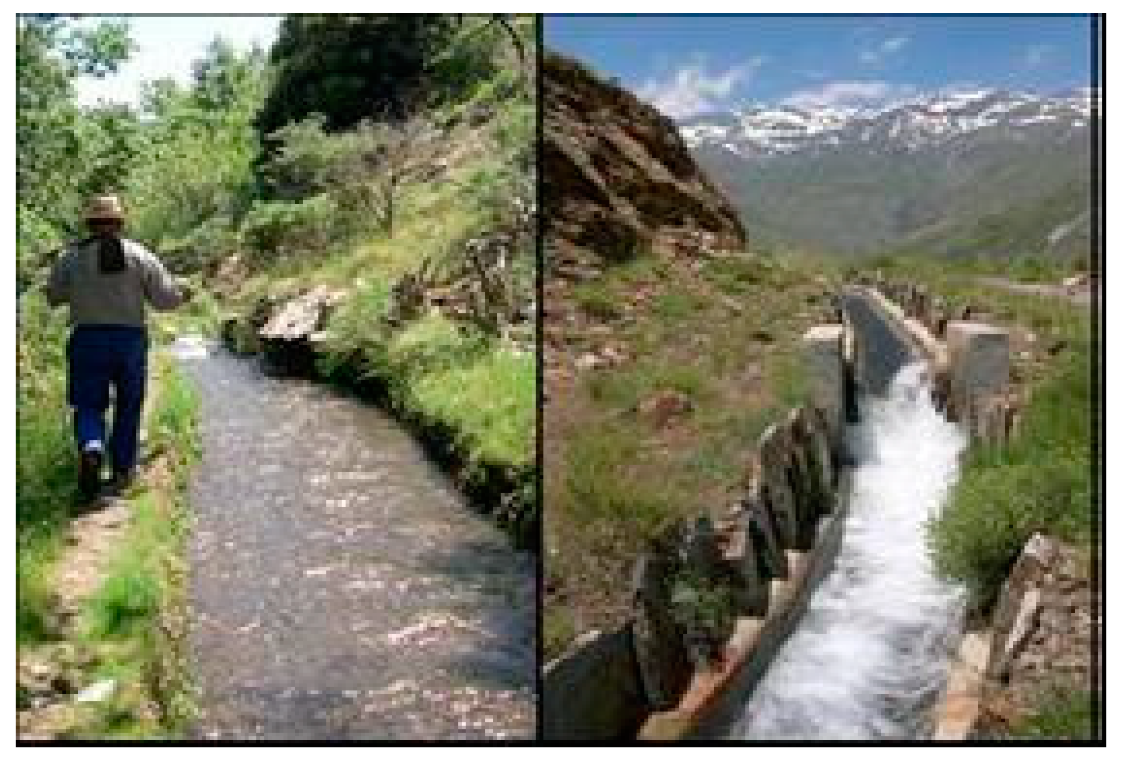
- Vivas, G.; Gómez-Landesa, E.; Mateos, L.; Giráldez, J.V. Integrated Water Management in an Ancestral Water Scheme in a Mountainous Area of Southern Spain; ASCE: Reston, VA, USA, 2009. [Google Scholar]
- Mateos, L.; Vivas, G.; Giráldez, J.V.; González-dugo, M.P. Origin, tradition and decline of the ancestral irrigation systems in the high Alpujarra, Spain. In Proceedings of the Workshop History of Irrigation, Drainage and Flood Control, ICID 22nd European Regional Conference, Pavia, Italy, 2 September 2007. [Google Scholar]
- De la Peña, J.L.; Ibarz, J.; Salgot, M. Water in the royal monastery of Santes Creus, Catalonia (Spain). In Proceedings of the 3rd Specialized Conference on Water and Wastewater Technologies in Ancient Civilizations, Istanbul, Turkey, 22–24 March 2012. [Google Scholar]
- Das, S.K.; Gupta, R.K.; Varma, H.K. Flood and Drought Management through Water Resources Development in India. Bull. World Meter. Organ. 2007, 56, 3. [Google Scholar]
- Postan, M.M. The Agrarian Life of the Middle Ages; Cambridge University Press: Cambridge, UK, 1966. [Google Scholar]
- Şentürk, F. Hydraulics of Dams and Reservoirs; Water Resources Publications: Highlands Ranch, CO, USA, 1994. [Google Scholar]
- Kuban, D. Tarih Vakfı yurt Yayını, Istanbul, A History of City: Istanbul; The Economic and Social History Foundation of Turkey: Istanbul, Turkey, 1996. [Google Scholar]
- Inancık, H.; Arı, B. Urbanism in Turkish-Islamic-Ottoman Tradition and Studies of İnalcık. H. J. Turk. Res. Lit. 2005, 3, 25–56. [Google Scholar]
- RTMCT. Ottoman Period Waterworks and Water Admınıstratıon System; Republic of Turkey Ministry of Culture and Tourism: Ankara, Turkey, 2005.
- DSİ. Water Resources in Turkey; General Directorate State Hydraulic Works: Ankara, Turkey, 2012. [Google Scholar]
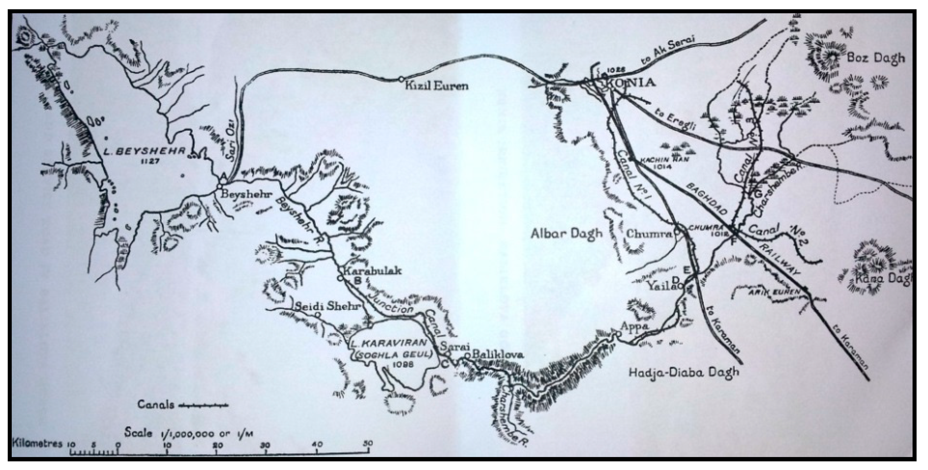
- Money, R.I. The irrigation of the Konia Plain. Geogr. J. 1919, 5, 298–303. [Google Scholar] [CrossRef]
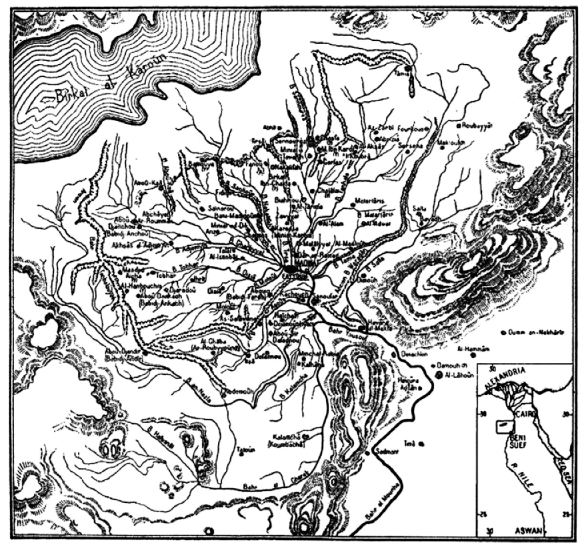
- Keenan, G. Fayyum Agriculture at the End of the Ayyubid Era: Nabulsi’s Survey. In Agriculture in Egypt: From Pharaonic to Modern Times; Bowman, A.K., Rogan, E., Eds.; Oxford University Press for the British Academy: Oxford, UK, 1999; pp. 287–299. [Google Scholar]
- Alan, M. An Irrigated Empire: The Vıew from Ottoman Fayyum. Int. J. Middle East Stud. 2010, 42, 569–590. [Google Scholar]
- Borsch, S.J. Environment and Population: The Collapse of Large Irrigation Systems Reconsidered. Comp. Stud. Soc. Hist. 2004, 46, 458–460. [Google Scholar] [CrossRef]
- Quataert, D. The Ottoman Empire–1700–1922, 2nd ed.; Cambridge University Press: Cambridge, UK, 2005. [Google Scholar]
- Mitchell, W. The Hydraulic Hypothesis. Curr. Anthropol. 1973, 14, 532–534. [Google Scholar] [CrossRef]
- Worster, D. Rivers of Empire: Water, Aridity & the Growth of the American West; Pantheon Books: New York, NY, USA, 1985. [Google Scholar]
- Reisner, M. Cadillac Desert: The American West and Its Disappearing Water; Penguin Books: New York, NY, USA, 1986. [Google Scholar]
- Freydank, K.; Siebert, S. Towards mapping the extent of irrigation in the last century: A time series of irrigated area per country. In Frankfurt Hydrology Paper 08; Institute of Physical Geography, University of Frankfurt: Frankfurt am Main, Germany, 2008. [Google Scholar]
- Shiklomanov, I.A. Appraisal and assessment of world water resources. Water Int. 2000, 25, 11–32. [Google Scholar] [CrossRef]
- Brown, L.B. Raising Water Productivity; Earth Policy Institute, Ratgers University: Washington, DC, USA, 2008. [Google Scholar]
- Kadigi, R.M.J.; Tesfay, G.; Bizoza, A.; Zinabou, G. Irrigation and Water Use Efficiency in Sub-Saharan Africa; Global Development Network: Washington, DC, USA, 2012. [Google Scholar]
- Xie, Y.; Zhou, X. Income inequality in todays’ China. Proc. Natl. Acad. Sci. USA 2014, 111, 6928–6933. [Google Scholar] [CrossRef]
- Aquastat Database. Available online: http://faostat.org (accessed on 30 November 2019).
- Faurès, J.M. The FAO Irrigated Area Forecast for 2030; Food and Agricultural Organization: Rome, Italy, 2002. [Google Scholar]
- Postel, S. Last Oasis: The Worldwatch Environment Alert Series; W.W. Norton and Company: New York, NY, USA, 1992. [Google Scholar]
- Shiklomanov, I.A. Comprehensive Assessment of the Freshwater Resources of the World: Assessment of Water Resources and Water Availability in the World; World Meteorological Organization and Stockholm Environment Institute: Stockholm, Sweden, 1997. [Google Scholar]
- Siebert, S.; Doll, P. Irrigation water use. A global perspective. In Global Change: Enough Water for All? Lozán, J.L., Graßl, H., Hupfer, P., Menzel, L., Schönwiese, C.D., Eds.; Universität Hamburg: Hamburg, Germany, 2007; pp. 104–107. [Google Scholar]
- Sojka, R.E.; Bjorneberg, D.L.; Entry, J.A. Irrigation: An historical perspective. In Encyclopedia of Soil Science, 1st ed.; Lal, R., Ed.; Marcel Dekker, Inc.: New York, NY, USA, 2002; pp. 745–749. [Google Scholar]
- Leibundgut, C.; Kohn, I. European Traditional Irrigation in Transition Part I: Irrigation in Times Past—A historic land use practice across Europe. Irrig. Drain. 2014, 63, 273–293. [Google Scholar] [CrossRef]
- Domokos, M.; Kálmán, M. Summary and conclusions, in Danube Valley. In History of Irrigation, Drainage and Flood Control; Csekő, G., Hayde, L., Eds.; ICID: New Delhi, India, 2004; pp. 679–715. [Google Scholar]
- Bucks, D.A.; Sammis, T.W.; Dickey, G.L. Irrigation for Arid Areas. In Management of Farm Irrigation Systems; Hoffman, G.J., Howell, T.A., Solomon, K.H., Eds.; ASAE: Washington, DC, USA, 1990; pp. 499–548. [Google Scholar]
- National Research Council (USA). A New Era for Irrigation; National Academy Press: Washington, DC, USA, 1996. [Google Scholar]
- National Research Council (USA). Water Transfers in the West: Efficiency, Equity, and the Environment; National Academy Press: Washington, DC, USA, 1992. [Google Scholar]
- UNESCO. The 2nd UN World Water Development Report: “Water, a Shared Responsibility”; UNESCO: Paris, France, 2006. [Google Scholar]
- Gleick, P. An Introduction to Global Fresh Water Issues. In Water in Crisis—A Guide to World’s Fresh Water Resources; Gleick, P., Ed.; Oxford University Press: New York, NY, USA, 1993. [Google Scholar]
- Kendall, H.; Pimentel, D. Constraints on the expansion of the global food supply. Ambio 1994, 23, 198–205. [Google Scholar]
- Howell, T.A. Irrigation’s Role in Enhancing Water Use Efficiency. In Proceedings of the 4th Decennial Symposium; Evans, R.G., Benham, B.L., Trooien, T.P., Eds.; ASAE: Washington, DC, USA, 2000; pp. 66–80. [Google Scholar]
- Rhoades, J.D. Sustainability of Irrigation: An Overview of Salinity Problems and Control Strategies. In Proceedings of the 1997 Annual Conference of Canadian Water Resources Association, Footprints of Humanity: Reflections on Fifty Years of Water Resources Development, Lithbridge, AB, Canada, 3–6 June 1997; pp. 1–40. [Google Scholar]
- Ghassemi, F.; Jakeman, A.J.; Nix, H.A. Salinisation of Land and Water Resources; University of New South Wales Press Ltd.: Canberra, Australia, 1995. [Google Scholar]
- Cerrillo, A. Los ocho naufragios del canal Segarra-Garrigues (The eigth failures of the Segarra-Garrigues canal). La Vanguardia Newspaper, 18 November 2005. [Google Scholar]
- WWAP. The United Nations World Water Development Report 4: Managing Water under Uncertainty and Risk, Vol. 1; UNESCO: Paris, France, 2012. [Google Scholar]
- Jensen, M.E.; Burman, R.D.; Allen, R.G. Evapotranspiration and Irrigation Water Requirements; ASCE Manuals and Reports on Engineering Practice, 70; ASCE: New York, NY, USA, 1990. [Google Scholar]
- Sojka, R.E. Understanding and Managing Irrigation-Induced Erosion. In Advances in Soil and Water Conservation; Pierce, F.J., Frye, W.W., Eds.; Sleeping Bear Press: Ann Arbor, MI, USA, 1998; pp. 21–37. [Google Scholar]
- Walker, W.R.; Zaccaria, D. Agricultural Water Management Challenges in the Western US. Discussion Paper. Presented at the NSF Water Workshop, Cairo, Egypt, 10–14 August 2014. [Google Scholar]
- Levidow, L.; Zaccaria, D.; Maia, R.; Vivas, E.; Todorovic, M.; Scardigno, A. Improving water-efficiency irrigation: Prospects and difficulties of innovative practices. Agric. Water Manag. 2014, 146, 84–94. [Google Scholar] [CrossRef]
- Angelakis, A.N.; Voudouris, K.S.; Tchobanoglous, G. Evolution of Water Supplies in the Hellenic World Focusing on the Water Treatment and Modern Parallels Water Supply. Available online: https://iwaponline.com/ws/article/doi/10.2166/ws.2020.032/72561/Evolution-of-water-supplies-in-the-Hellenic-world (accessed on 30 December 2019).
- UN. Population 2030: Demographic Challenges and Opportunities for Sustainable Development Planning; UN: New York, NY, USA, 2015. [Google Scholar]
- Paranychianakis, N.V.; Salgot, M.S.; Snyder, A.; Angelakis, A.Ν. Quality Criteria for Recycled Wastewater Effluent in EU-Countries: Need for a Uniform Approach. Crit. Rev. Environ. Sci. Technol. 2015, 45, 1409–1468. [Google Scholar] [CrossRef]
- Tzanakakis, V.E.; Koo-Oshima, S.; Haddad, M.; Apostolidis, N.; Angelakis, A.N. The History of Land Application and Hydroponic Systems for Wastewater Treatment and Reuse. In Evolution of Sanitation and Wastewater Management through the Centuries; Angelakis, A., Rose, J., Eds.; IWA Publishing: London, UK, 2014; pp. 459–482. [Google Scholar]
- Salgot, M.; Oron, G.; Cirelli, G.; Dalezios, N.R.; Díaz, A.; Angelakis, A.N. Criteria for Wastewater Treatment and Reuse under Water Scarcity. In Handbook of Drought and Water Scarcity: Environmental Impacts and Analysis of Drought and Water; Eslamian, S., Eslamian, F., Eds.; CRC Press: Boca Raton, FL, USA, 2016. [Google Scholar]
- Hill, D.R. A History of Engineering in Classical and Medieval Times; Croom Helm: London, UK, 1984. [Google Scholar]
- Dillehay, T.D.; Eling, H.H., Jr.; Rossen, J. Preceramic Irrigation Canals in the Peruvian Andes. Proc. Natl. Acad. Sci. USA 2005, 102, 17241–17244. [Google Scholar] [CrossRef] [PubMed]
- Rodda, J.C.; Ubertini, L. The Basis of Civilization—Water Science; ISHS Proceedings & Reports: Wallingford, UK, 2004; Volume 286, p. 342. [Google Scholar]


| Decade | Annual Growth (M Ha) | Annual Rate of Growth (%) |  |
| 1950s | 16.5 | 4.30% | |
| 1960s | 13.3 | 2.40% | |
| 1970s | 16.8 | 2.50% | |
| 1980s | 14.5 | 1.70% | |
| 1990s | 12.6 | 1.30% |
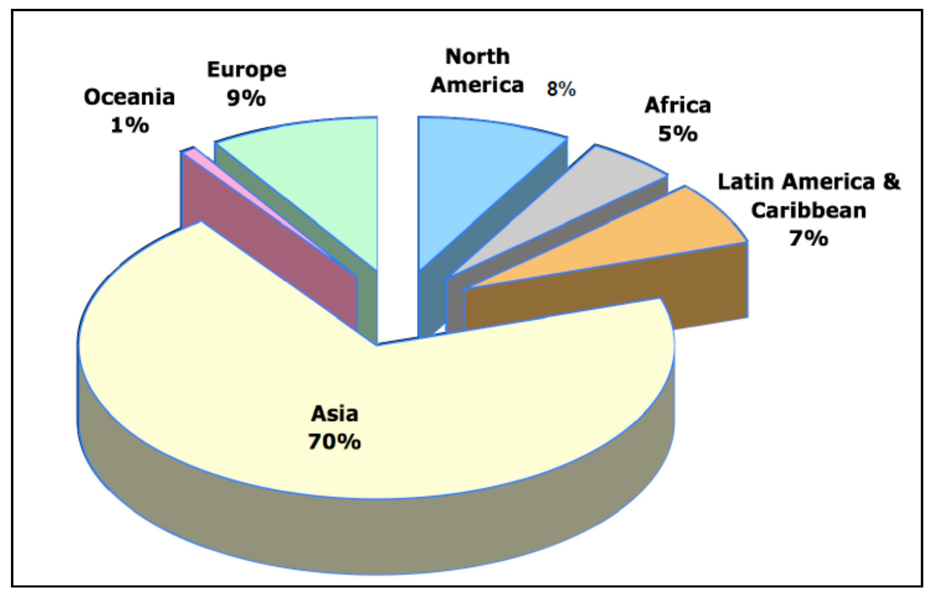
| Region | Irrigated Area (Million hm2) | Irrigated Area as % of Cultivated Land | ||||
|---|---|---|---|---|---|---|
| Year | 1980 | 1990 | 2003 | 1980 | 1990 | 2003 |
| World | 193 | 224.2 | 277.1 | 15.8 | 17.3 | 17.9 |
| Africa | 9.5 | 11.2 | 13.4 | 5.1 | 5.7 | 5.9 |
| Asia | 132.4 | 155 | 193.9 | 28.9 | 30.5 | 34 |
| Latin America | 12.7 | 15.5 | 17.3 | 9.4 | 10.9 | 11.1 |
| Caribbean | 1.1 | 1.3 | 1.3 | 16.4 | 17.9 | 18.2 |
| North America | 21.2 | 21.6 | 23.2 | 8.6 | 8.8 | 9.9 |
| Oceania | 1.7 | 2.1 | 2.8 | 3.4 | 4 | 5.4 |
| Europe | 14.5 | 17.4 | 25.2 | 10.3 | 12.6 | 8.4 |
| Period (ca) | Achievements | Comments |
|---|---|---|
| 5000–2500 BC | The first confirmed evidence of habitation and the first farmers. The first successful effort in developing agricultural irrigation. | In Mesopotamia |
| 5000–2200 BC | Emergence of the primitive irrigation and drainage engineering, and emergence of wells for irrigation. | In ancient China |
| ca. 3100 BC | Egyptians practiced basin irrigation using the loading of the Nile to inundate land plots, which had been surrounded by dykes. | In ancient Egypt |
| 3050–2050 BC | Early irrigation systems in Egypt and Mesopotamia | |
| 3000–1600 BC | Ancient Nubians developed a form of irrigation by using waterwheel-like device called sakia. | In ancient Sudan |
| 2500–1450 BC | Irrigated and drainage agricultural lands in the eastern Crete. Major irrigated crops were olives and grapes | Minoan settlements (e.g., Choiromandres, Zakros, Agia Triada, Messara valley) |
| 2500–1900 BC | Irrigation of agricultural lands. | In Mohenjo-daro and other centers located in modern Pakistan. |
| 2200–771 BC | Emergence of farmland canal systems. | In ancient China |
| 2000–1000 BC | Cultures and civilizations in the Niger river region practiced irrigation based on wet season flooding and water harvesting in the first or second millennium BC. | In sub-Saharan Africa |
| 1500–800 BC | The realization of the importance of irrigation is evident already from the myths of ancient cultures. Irrigation of Kopais valley in the central Greece. | In various Mycenaean cities (in south Greece) |
| 800–500 BC | Development of irrigation and drainage technology for field cultivation and gardening. | Mainland Greece, Western Greece and islands in the Aegean Sea |
| ca. 800 BC | The Qanat technology was developed which is among the oldest known irrigation methods and still use today in several parts of the world. | In Persia and other places |
| ca. 300 BC | The irrigation works in the reign of King Pandukabhaya and which were under continuous development for the following thousand years, were one of the most complex irrigation systems of the ancient world. | In ancient Sri Lanka |
| 256 BC | In the Szechwan region, belonging to the State of Qin, the Dujiangyan irrigation system was built to irrigate an enormous area of farmland that still supplies the water. | In ancient China |
| 246 BC | In the central Shaanxi Plain belonging to the State of Qin, the Zhengguo Canal irrigation system was built to irrigate an enormous area of farmland that today still supplies the water. | In ancient China |
| 167 BC–330 AD | Romans invented the Roman concrete (opus caementitium) which allowed the construction of long canals, very large bridges and long tunnels in soft rock. | In Roman period |
| 581–1279 AD | The pond-canal polder system in the Taihu Lake basin and projects for resisting seawater intrusion and storing freshwater in the southeast coast became the most representative water conservancy of this period. | In ancient China |
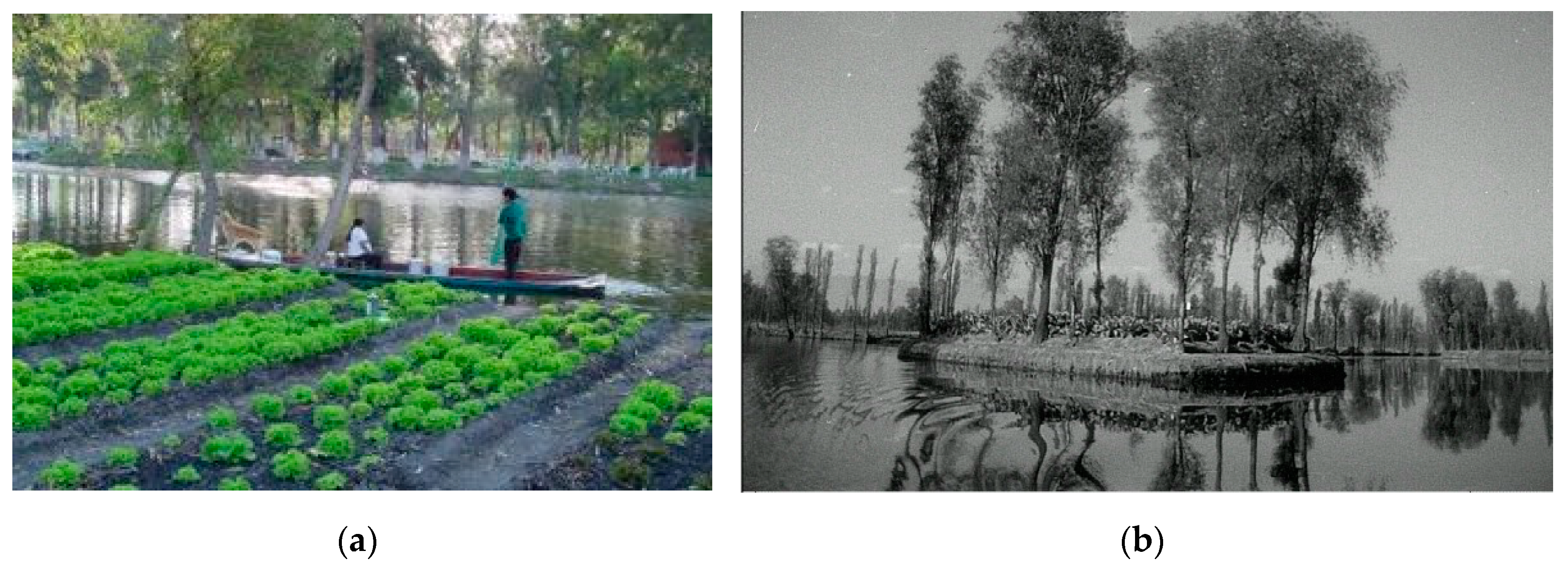
| 1200–1500 AD | Use of Chinampas which is a crop growing method used by the Aztec civilization consisting of small manmade islands placed on lakes in marshes with no need for irrigation and optimizing the use of agricultural land, water and waste to raise yields | In Mexico |
| 1279–1911 AD | The polders in the Poyang Lake and Dongting Lake of the Yangtze river basin and dike enclosure at the Pearl river Delta both entered the large-scale development period, that made the Yangtze river basin and the Pearl river basin become economic centers of China. | In ancient China |
| 1299–1923 AD | Most of the water transmission lines built in Ottoman times. Irrigation activity was densely performed in Fertile Crescent region (Mesopotamia, Egypt, Jordan etc.) during Ottoman period | In Anatolia and neighboring regions |
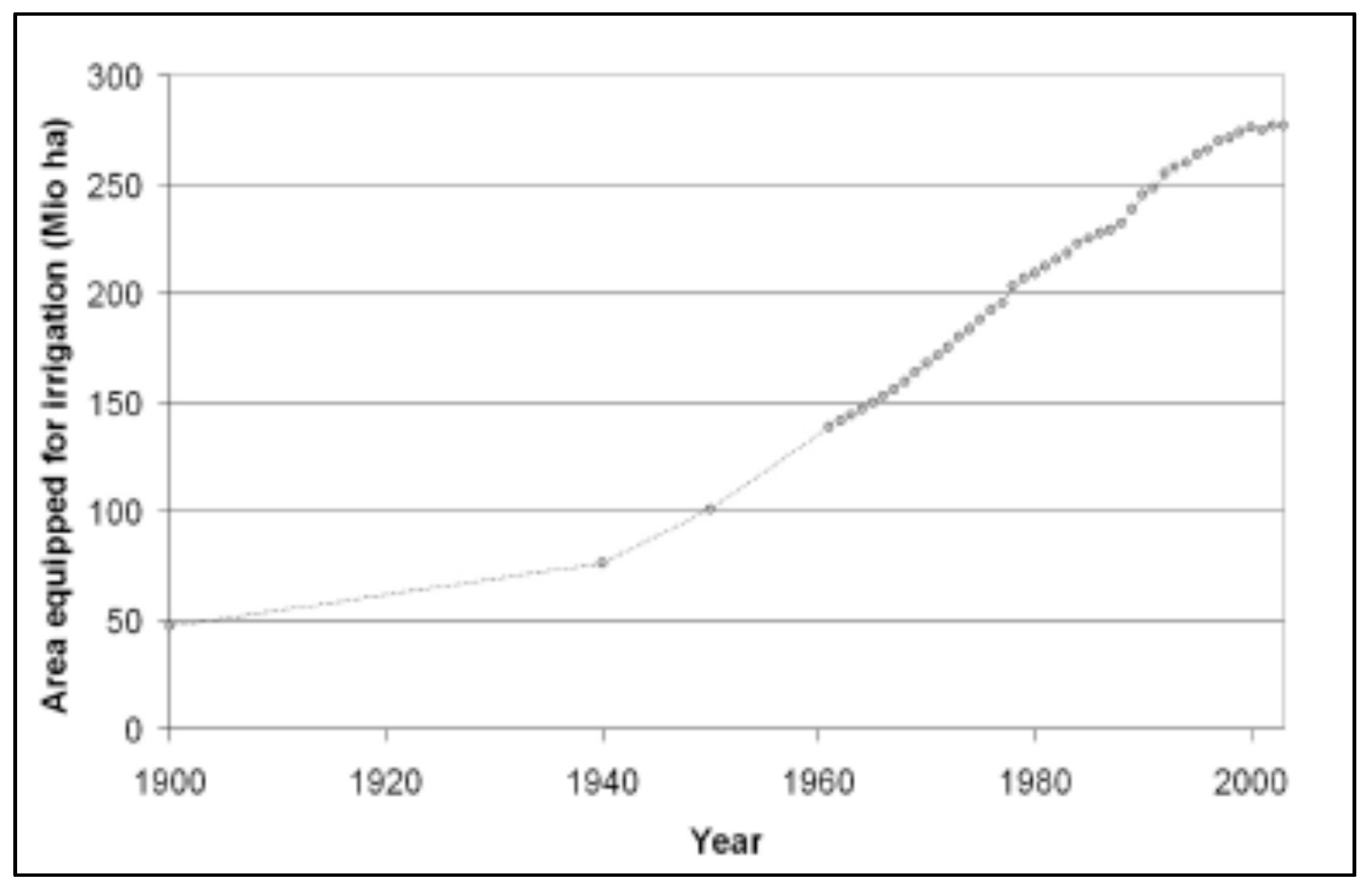
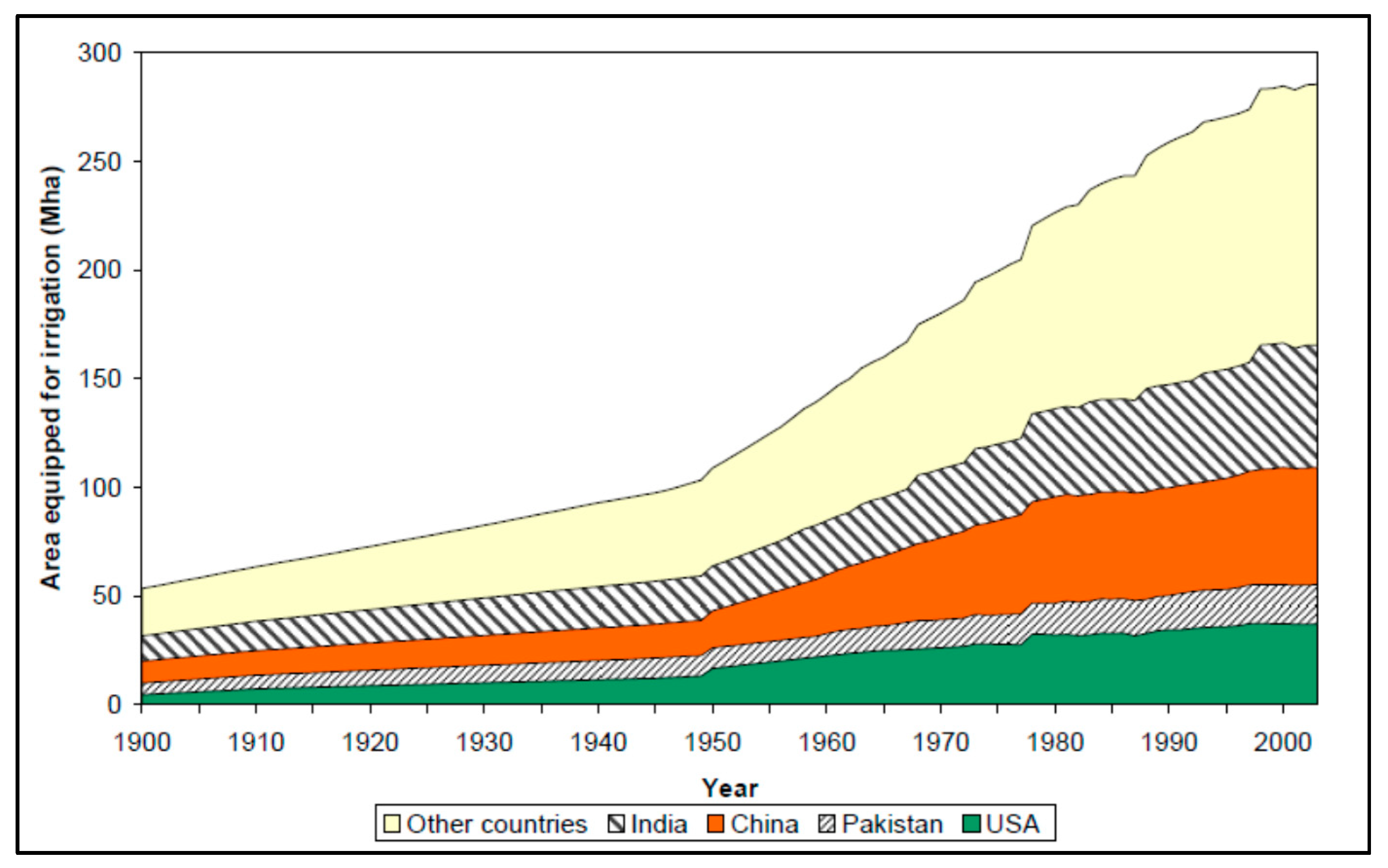
| 1900–Today | It was estimated that around 1800 the extent of irrigated land was about 8 M ha, and it reached 47 M ha million hm2 around 1900 with water consumption for irrigation 500 billion m3 per year. The top four countries with the largest area equipped for irrigation in 1900 were India, China, Pakistan and USA. Total water demand is expected to increase from 4000 today to 5500 billion m3/year in 2050 with irrigation to be the major use. | In the entire World |
© 2020 by the authors. Licensee MDPI, Basel, Switzerland. This article is an open access article distributed under the terms and conditions of the Creative Commons Attribution (CC BY) license (http://creativecommons.org/licenses/by/4.0/).
Share and Cite
Angelakιs, A.N.; Zaccaria, D.; Krasilnikoff, J.; Salgot, M.; Bazza, M.; Roccaro, P.; Jimenez, B.; Kumar, A.; Yinghua, W.; Baba, A.; et al. Irrigation of World Agricultural Lands: Evolution through the Millennia. Water 2020, 12, 1285. https://doi.org/10.3390/w12051285
Angelakιs AN, Zaccaria D, Krasilnikoff J, Salgot M, Bazza M, Roccaro P, Jimenez B, Kumar A, Yinghua W, Baba A, et al. Irrigation of World Agricultural Lands: Evolution through the Millennia. Water. 2020; 12(5):1285. https://doi.org/10.3390/w12051285
Chicago/Turabian StyleAngelakιs, Andreas N., Daniele Zaccaria, Jens Krasilnikoff, Miquel Salgot, Mohamed Bazza, Paolo Roccaro, Blanca Jimenez, Arun Kumar, Wang Yinghua, Alper Baba, and et al. 2020. "Irrigation of World Agricultural Lands: Evolution through the Millennia" Water 12, no. 5: 1285. https://doi.org/10.3390/w12051285
APA StyleAngelakιs, A. N., Zaccaria, D., Krasilnikoff, J., Salgot, M., Bazza, M., Roccaro, P., Jimenez, B., Kumar, A., Yinghua, W., Baba, A., Harrison, J. A., Garduno-Jimenez, A., & Fereres, E. (2020). Irrigation of World Agricultural Lands: Evolution through the Millennia. Water, 12(5), 1285. https://doi.org/10.3390/w12051285