Article

Collaborative Action and Social Organization in Remote Rural Regions: Autonomous Irrigation Arrangements in the Pamirs of Tajikistan

Institute of Geographical Sciences, Freie Universität Berlin, Malteserstr. 74-100, House K, 12249 Berlin, Germany
Water 2020, 12(10), 2905; https://doi.org/10.3390/w12102905
Submission received: 31 August 2020 / Revised: 10 October 2020 / Accepted: 14 October 2020 / Published: 17 October 2020
(This article belongs to the Special Issue Research on Irrigation Strategies for Sustainable Water Management)

Abstract

:
This paper proposes a bottom–up “nexus medium” perspective to examine and understand social organization and how socio-ecological challenges in remote rural regions are dealt with in communities that receive only limited external support. While “nexus mediums” constitute substances, matter, or objects that combine manifold vital meanings and can be seen as socially constructed and materialized arenas of social interaction, autonomous resource management is seen as a means of local social organization. Taking water as the nexus medium of choice allows us to generate locally informed insights about the role of this scarce resource for the everyday life and social organization of communities inhabiting arid rural areas. This reasoning will be exemplified by three local case studies conducted during empirical research in the Pamirs of Tajikistan utilizing a mix of qualitative methods. The findings reveal how many fundamental everyday-life-related aspects and activities of the studied communities are related to water, and how these communities are organized around common water use and management arrangements that are based on joint decision-making, shared benefits and responsibilities, and collaborative action. The “nexus medium” concept appears to be an appropriate approach for research that seeks to understand from a local perspective how communal living is organized and how socio-ecological challenges are addressed.

1. Introduction

The resolution of complex social and environmental issues, as exemplified by the Sustainable Development Goals, and the reliable supply and usage of resources in the context of Global Change require “systems thinking” [1] and integrated action. In this regard, so-called “nexus” approaches have been applied in recent years in the context of globalization and global environmental change to top–down development politics [2,3]. This has been accompanied by solution-oriented scientific research [1,4,5,6,7,8]; development-oriented measures [9,10]; and profit-seeking economic activities [11,12] that deal with interwoven issues related to water, energy, and food resources.
The scientific state-of-the-art thinking specifies the “resource nexus” as being “a heuristic for understanding critical interlinkages between uses of different natural resources for systems of provision such as water, energy, and food” [8] (p. 3). Accordingly, the common denominator of political, development-oriented, scientific, and economic applications of the nexus approach appears to be a deductive reasoning that “leads to necessary statements embodied in theories” [13] (p. 342), or, in other words, to biased understandings of both the causes and origins of the problems addressed and the possible solutions. However, a critical downside of such top–down approaches is that the micro-scale of the everyday lives of people, local understandings and manifestations of the studied challenges, and the unintended effects and trade-offs of the measures taken can be overlooked. This paper turns attention to this blind spot and addresses these aspects from an emic, bottom–up perspective. It applies an inductive reasoning that explicitly pays attention to the “relations (…) amongst phenomena that have been observed empirically” [13] (p. 342).
The purpose of this paper is to introduce and apply, for the first time, the bottom–up “nexus medium” concept to generate locally informed knowledge about, and understanding of, the socio-ecologically situated resource management arrangements of rural communities. These management arrangements are interpreted, here, as being local-specific autonomously organized responses to greater social and environmental challenges. In this approach, a nexus medium constitutes a substance, matter, or object that is characterized by the fact that (at least a significant share of) a given population or community assigns manifold vital and intertwined meanings to it. Nexus mediums, thus, unite multiple meanings in themselves, function as connecting nodes between the people, and can, therefore, be seen as socially constructed and materialized arenas of social interaction. At the same time, the concept envisions nexus mediums as being a means by which local communities organize themselves, act together, and through which they interact with their social and natural environment.
These deliberations will be exemplified through the presentation of findings from empirical field research conducted between 2014 and 2018 in three communities in the remote rural mountain region of the Western Pamirs, which administratively belongs to the Gorno-Badakhshan Autonomous Oblast (GBAO) of Tajikistan. Additionally, archival research was conducted to gather historical background information to provide the foundation for a better understanding of the current situation.
An initial literature review [14,15,16,17,18] revealed that water for local food and fodder production is one of the most important factors for sustaining local livelihoods in the (semi-)arid Pamir Region due to the interplay of challenging environmental and social conditions. Inspired by Netting’s [19] study on village irrigation “system(s) nobody knows” (p. 67) in the Swiss Alps and Israr-ud-din’s [20] research on social organization and irrigation arrangements in the Eastern Hindukush, I ask if taking water as the prism of inquiry and nexus medium of choice would allow for the emergence of differentiated and empirically based insights about local-specific forms of social organization, collaborative action, and common resource management arrangements of the people inhabiting the study region of the Western Pamirs. If the approach is able to provide the information and insights being sought, the proposed “nexus medium” perspective can be seen as an appropriate approach for research that is interested in locally informed insights about how communal living together is organized and how socio-ecological challenges are practically addressed.
In the following, I review the reasoning behind the nexus medium approach, present the applied methods and materials used, and introduce the study sites (Section 2). This is then followed by the main focus of the paper, Section 3 and Section 4, which present and discuss the results of the research. The results are divided into two subsections. The first subsection draws a systematic picture of the manifold meanings ascribed to water by the inhabitants of the chosen communities. The second subsection presents local-specific forms of collective resource management and social organization around irrigation issues. In the conclusion, I reflect on the potentials and limitations of autonomous irrigation water management arrangements in the Western Pamirs to organize social groups and address socio-ecological challenges, and on the theoretical nexus medium perspective in terms of generating locally informed knowledge for an empirically grounded understanding of such topics.

2. Theory, Methods and Materials, and the Study Sites

2.1. The Nexus Medium Approach

The starting point of the nexus medium concept I present here for the first time is a critique of blueprint, top–down nexus concepts to understand the interwoven challenges related to water, energy, and food resources. Nexus concepts seem to pay little attention to the micro-scale of the everyday lives of people, local understandings and manifestations of the studied problems, and the local effects and unintended trade-offs of externally initiated measures applied to address these interwoven challenges. The nexus medium approach, instead, applies an emic, bottom–up perspective that enables findings and results about the lifeworld and everyday lives of people, collaborative action, and social organization that primarily stem from the perspectives, perceptions, understandings, and assessments of local communities and their individual members. It is, therefore, a more inductive, explorative, and open-ended concept that does not try to test pre-formulated hypothesis but tries, instead, to understand the studied problem through mainly qualitative material obtained through the application of non-standardized empirical field research methods. In this regard, it represents an attempt to contribute a practical research approach to the growing scholarship on decolonizing knowledge production in, and about, the Global South.
The concept rests on three basic assumptions. First, a nexus medium has manifold vital and intertwined meanings for a significant share of a group of people. The second assumption is that nexus mediums are seen as a means by which local communities organize themselves, act together, and through which they interact with their social and natural environment. Hence, the first step of an investigation is to identify a substance, matter, or object that is distinguished by these characteristics. Third, the identified resource use and management regimes, as well as organizational arrangements are influenced by, as well as influence, the respective societal and environmental contexts. These arrangements are, therefore, local-specific (Figure 1).
Depending on the respective societal and ecological contexts, forests, pastures, arable land, food, or any other conceivable substance, matter, or object can be seen as possible nexus mediums as long as they unite multiple vital meanings in themselves and function as connecting nodes between the people. They can, therefore, be seen as materialized means and socially constructed arenas of social interaction. The following brief explanation seeks to clarify this idea: In an arid rural area where people receive only limited external support, water can be seen as a nexus medium. Sufficiently available running water could allow irrigation agriculture for local food and fodder production and, for instance, the generation of electricity (economic meaning). The labor division within households, as well as health- and sanitation-related issues are often strongly related to the availability, quantity, and quality of water (social meaning). Water can play a central role in recreational and life cycle events and/or be charged with transcendental meanings (cultural meaning). Finally, water can also be seen as an important factor for local microclimates or be associated with natural hazards (ecological meaning). These examples are not exhaustive, and there are possibly many other meanings that can be ascribed to a nexus medium. Additionally, these meanings do not necessarily belong to just one of the four mentioned vectors but can serve multiple purposes depending on the knowledge, understandings, perspectives, and interests of the respective social group or individual persons that are involved in the interactions related to the chosen nexus medium. Finally, the people must autonomously implement nexus-medium-related management regulations and usage regimes to coordinate the many interests of the involved actors and the resulting practices, since there is no external player overlooking and controlling these interactions.

2.2. Methodology and Materials

The goal of this study was to generate an empirically based and locally informed understanding of how local communities in remote rural areas organize coexistence and address social and ecological challenges. This requires an open-ended approach to the research topics. Due to their non-predefined character, qualitative methods are particularly suitable to serve this purpose. It was expected that no single method would provide sufficient material to understand the complex features of the research topic. Therefore, a mix of different qualitative methods, including narrative and semi-structured interviews, a group interview, transect walks, observations, field notes, and mapping, was applied during several field research campaigns conducted between 2014 and 2018. This also allowed for a triangulation of the insights gathered to overcome ambiguities and check the plausibility of information and statements provided by the respondents.
The first studies for this paper were conducted in 2014 as part of a joint study project of the Centre for Development Studies at the Institute of Geographical Sciences of the Freie Universität Berlin (Germany), the State University in Gorno-Badakhshan’s administrative center of Khorog, and the local office of the German development corporation Deutsche Gesellschaft für Internationale Zusammenarbeit GmbH (GIZ) in which students in the settlement of Sizhd conducted a study on irrigation agriculture under my guidance as was proposed by the Tajik partners (see Section 2.3). In addition to transect walks, mapping, and non-participatory observation, local officials and functionaries, a representative of the development organization Mountain Societies Development Support Programme (MSDSP) of the Aga Khan Development Network (AKDN), contemporary witnesses, and representatives of local households were interviewed.
In the spring of 2015, I undertook an exploration trip to GBAO’s remote southern district of Ishkāshim during which expert interviews were conducted with representatives of the development organizations GIZ and CAMP Tabiat, the latter being a branch of the Central Asian Mountain Partnership (CAMP) Ala-Too Public Foundation in Kyrgyzstan, on the general issues of resource management in the region. Additionally, I conducted narrative interviews with inhabitants of various villages, focusing on livelihoods, resource use, and everyday life. These conversations, as well as all future meetings and explorations, were carried out with local accompaniment. These knowledgeable persons established contact to representatives of the visited places, identified suitable respondents, and ensured that I had an appropriate introduction as a male researcher from a German university who is interested in rural livelihoods, self-organized management and usage of natural resources, collaborative action, and local social organization. Since Russian proved to be the language most interview partners and I shared, most of the interviews were conducted without translation. In the few cases where this was not possible, local assistants interpreted from Tajik or Wakhi, the Pamirian language spoken in the eastern part of the Ishkāshim District, into Russian. In the village of Shirgin (see Section 2.3), direct contact was established even before the trip, which enabled long-term appointments and led to detailed conversations with representatives of the settlement about current and historical issues of local livelihoods, resource use with specific emphasis on irrigation agriculture, and aspects related to the everyday lives of the people. Based on this, I decided to select Shirgin as the second case study site for the coming year.
In the summer of 2016, the research focus was, therefore, entirely on this village, where further narrative and semi-structured conversations with local officials, functionaries, contemporary witnesses, and household representatives, as well as non-participatory observations, transect walks, and mapping took place. Further meetings were held in Khorog with the natural resource management expert of the MSDSP and an agronomist and plant breeding expert from the Pamir Experimental Agronomic Station of the Academy of Agricultural Sciences of the Republic of Tajikistan (PEAS). During these talks, I learned about the Water User Association (WUA) in the municipality of Porshnev (see Section 2.3), which is one of the few existing WUAs in Gorno-Badakhshan.
In order to learn more about the supralocal approach to autonomous irrigation management in Porshnev Municipality, which I chose as the third case study, talks were held in the summer of 2018 in the course of another German-Tajik study project, this time implemented in cooperation with the University of Central Asia (UCA) in Khorog, with representatives of the WUA. I spoke with the local administration, and local households, as well as a doctor in a walk-in clinic and an amateur historian. Remaining open questions were asked and answered by email after I had left the study region. The electronic newsletter of the WUA provided further useful information on the work of this grassroots organization [21]. Three additional meetings were held in 2018 with the MSDSP expert on natural resource management, the agronomist from the PEAS, and an agricultural scientist and expert for rural development at the UCA. Finally, a third short visit of Shirgin Village was conducted to identify the latest local developments by speaking with a teacher, a farmer, and the head of the village youth.
Overall, eight conversations took place with five experts representing the development organizations MSDSP, GIZ, and CAMP Tabiat; the research institute PEAS; and the higher education institution UCA. The general selection criteria for these respondents was that they were considered to be experts on societal, legal, and environmental issues relevant for resource use and management in the Pamirs, in particular related to water, as well as carriers of expert knowledge on the specific challenges of irrigation agriculture and external efforts to improve both resource use and management and the living conditions in the region.
Altogether, fifty-nine narrative and semi-structured interviews and one group meeting were conducted with representatives from the three rural study sites mentioned above and introduced in detail in Section 2.3. The interviews included communications with heads of the villages (raiskho-i kishloq), representing the formal local administration; heads of farmers’ organizations (raiskho-i khojagi-i dekhqoni); employees of the WUA of the municipality of Porshnev; and local leaders and functionaries such as water masters (mirābon), religious dignitaries (khalifakho), a head of the village youth (rais-i javonon), and village elders (muisafedon/aksaqalkho). The latter are respected for their age, accumulated local knowledge, experiences, and standing within the respective community and, therefore, also considered to be local leaders, along with other knowledgeable people such as canal managers (mirjuikho), local amateur historians, farmers (dekhqonon), and teachers (omuzgoron). Most respondents were male adults, due to the dominance of men in the administration, as well as within the sphere of irrigation governance and management of the local communities. The low number of female interview partners may also be due to the combination of my positionality as a male Western academic and the widespread gender-based division of social roles and responsibilities in the studied local communities, which lead to the situation that it is usually men who take on the role of interview partners. However, three women working as a teacher, doctor, and a nurse, as well as two female heads of households were interviewed to consider female perspectives and knowledge. Table 1 provides an overview over the interviews conducted, as well as the institutional background, professional or social status, and gender of the respondents.
The aim of the conversations with local officials, leaders, functionaries, knowledgeable persons, and household representatives was to gather statements and information about, including assessments and perceptions of, the specific socioeconomic and environmental conditions, features, and challenges of the studied communities; the livelihoods of individual households; the diverse meanings ascribed to water; the spatiotemporal variance in water availability; irrigation water supply infrastructure and its maintenance; local water management bodies and institutions; the actors involved in water management; and the management and decision-making processes, as well as irrigation practices and daily tasks connected with the issue of practicing land cultivation for local food and fodder production. Adopting an oral history approach, in the sense of a “historical reconstruction of the past which is based on oral sources” [22], elderly people were asked about their experiences, memories, and perceptions regarding the manifold meanings ascribed to water and information about the water supply and irrigation in the past and how this knowledge informs current activities and practices. The approach to talk to these contemporary witnesses was chosen because there are comparatively few detailed historical publications on local-specific water management and water use practices in the Western Pamirs available [16,17,23,24].
The documentation of these conversation proved to be more challenging than expected. In the early stages of the study, it became clear that audio recordings of the conversations were oftentimes not desired by the interview partners. Therefore, simple notebooks were used to first record analog jottings during, or immediately after, the interviews, and then they were transposed into digital transcripts later the same day [25]. The names of interview partners have been changed or omitted in this paper to ensure anonymity.
Information on the environmental conditions and physical components of the irrigation arrangements including natural features such as glaciers, snow fields, and creeks and the built environment such as ponds, canals, and locks were collected, also noted in analog notebooks, and mapped in the course of twelve transect walks: three in Sizhd, seven in Shirgin, and two in Porshnev. The collected material was used to generate schematic maps of the spatial arrangement of the main water sources or lines of the three study sites. These explorative inspections were combined with non-participatory observations of everyday life activities and of local monitoring and water distribution practices. Here as well, I kept timely systematic field notes of my observations and experiences, as well as impressions and assessments [25]. These entries and the interview transcripts form the central basis of the results presented in Section 3.
Finally, historical information was sought in the Archive of the Institute of Oriental Manuscripts of the Russian Academy of Sciences and the Archive of the Russian Geographical Society in St. Petersburg, the former capital of the Russian Empire, which was the colonial ruling power in Central Asia in the second half of the 19th century and the early 20th century; the Russian State Military History Archive in Moscow; and the Central State Archive of the Republic of Uzbekistan in Tashkent, where the seat of the Russian Colonial Administration of the Governor-Generalship Turkestan was located. This historical research served mainly to identify place-specific information, contexts, and preconditions for current rural everyday practices, livelihoods, and autonomous resource management and usage arrangements. Reports, letters, and statistics including demographic numbers from representatives of the Russian and the Soviet military, diplomatic bodies, and the regional administration provided patchy but useful background information on the historical everyday life conditions, challenges, and livelihoods, as well as resource management and usage regimes of local communities in the Western Pamirs.
The data and information gathered during the empirical field work and the archival research were put into writing. These texts were subjected to a qualitative content analysis [26]. As a first step, the texts were assigned to one of four text genres: interview protocols, historical testimonies of third parties (archival material), notes of own observations and experiences, and personal impressions and assessments. This step was followed by a systematic and separate review of the texts of each genre, and the assignment of individual text segments into different categories—meanings attributed to water, water management and use, collaborative activities, social organization, and socio-ecological conditions and challenges—by considering the social role and positionality of the respective informant or, in the case of historical sources, of the author. Each category included additional specifically coded subcategories, which allowed a more precise allocation of the contents [26]. These subcategories encompassed differentiated meanings ascribed to water; practices, actors, spatiotemporal aspects, and social processes in the management and use of water, collaborative action, and social organization; as well as the nature, mode of operation, and effects of the respective societal and ecological conditions and challenges. From these systematized compilations, written and “thickly described” [27] representations of the individual facets of the study were prepared by means of deliberate and reflected interpretation of the material.

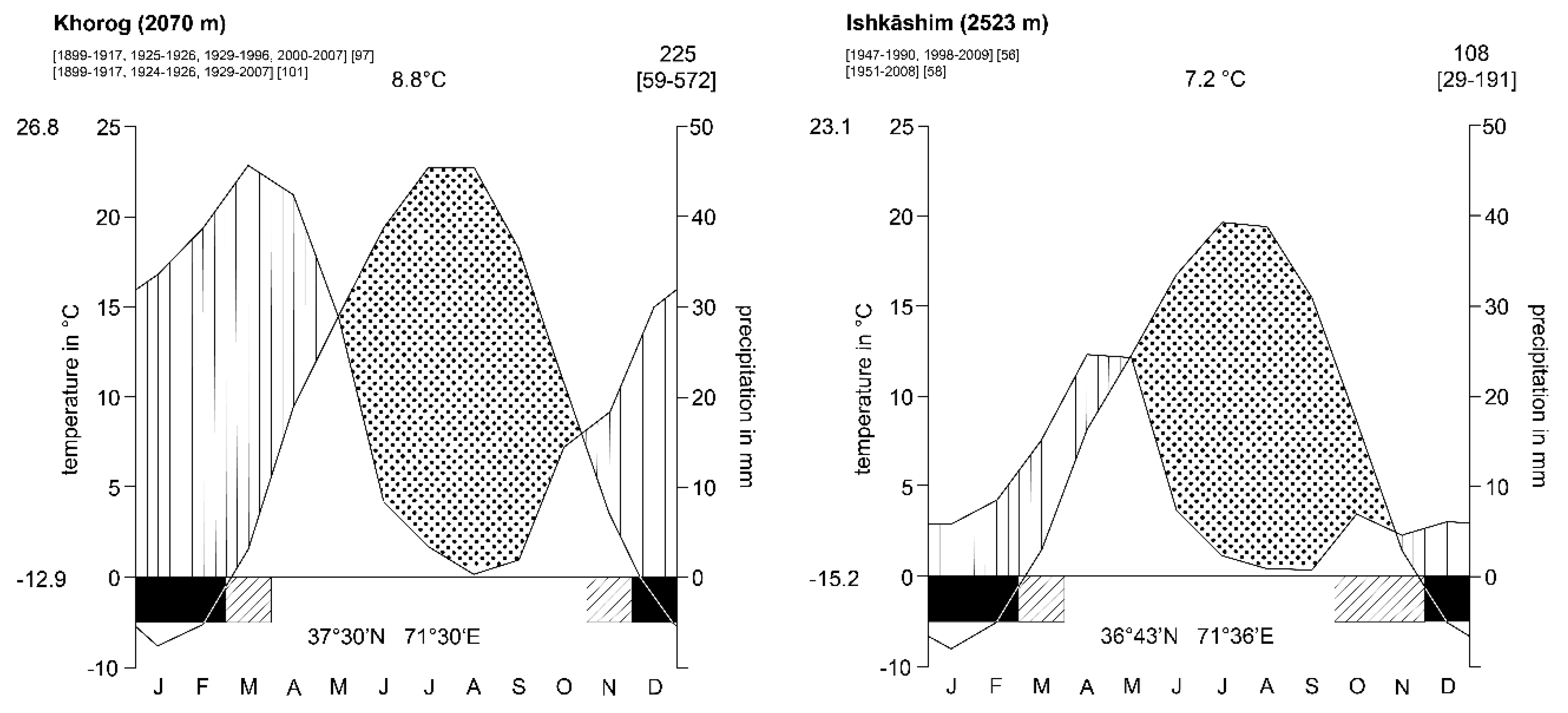
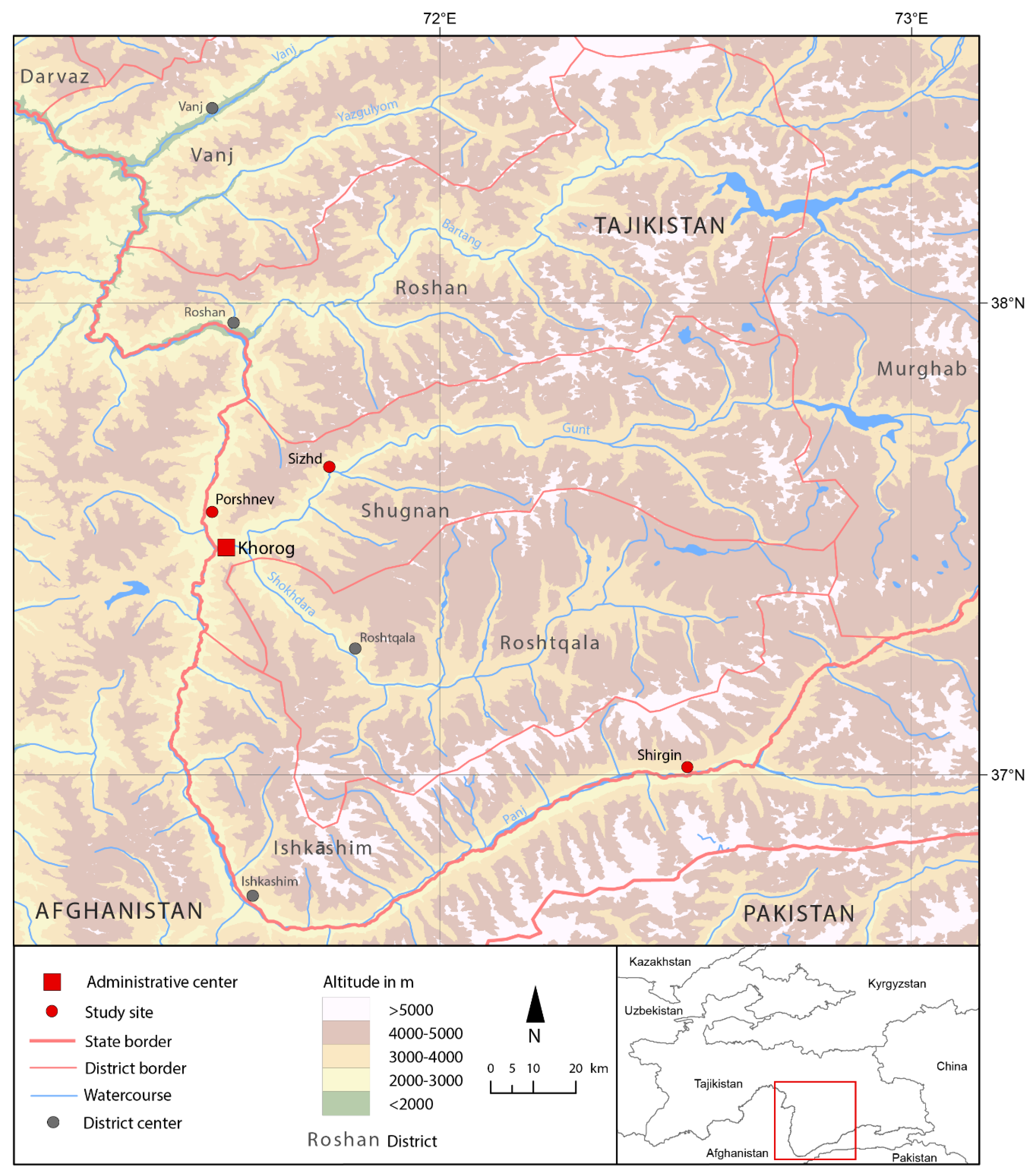
2.3. Three Study Sites in the Western Pamirs in Tajikistan

The high mountain region of the Western Pamirs lies in the remote eastern part of the country. It is characterized by several environmental, historical, and socio-cultural features that make it an attractive place to study the everyday lives, collaborative action, and autonomous resource management and usage approaches to understand local social organization through the prism of the nexus medium of water.
One vital characteristic is that the (semi-)arid conditions of the Western Pamirs permit the cultivation of land plots on alluvial soil that cover the flat valley bottoms and debris cones for local food and fodder production based on hill irrigation. Unfortunately, as for many other regions of High Asia, the network of meteorological stations in the Pamirs is patchy and provides only an incomplete picture of the climatic conditions within the study region. Many measuring stations are located in the valleys near the settlements and, therefore, are not necessarily representative for larger mountainous areas, especially for higher altitudes where the precipitation values are much higher [28,29]. Despite this shortcoming, the climate diagrams of Khorog and the settlement of Ishkāshim provide an adequate picture of the (semi-)arid climatic conditions in selected cropland areas of the Western Pamirs where the study sites of this research are located (Figure 2).
The results presented and discussed in the following sections are mainly based on information that was collected in three rural study sites: (i) the municipality (jamoat) of Porshnev of the Shugnan District (nokhiya) located north of Khorog; (ii) the village (dekha) of Sizhd at the Gunt River, which is also located within the nokhiya of Shugnan at a distance of about 35 km to the northeast of Khorog; and (iii) the village of Shirgin, situated within Ishkāshim District around 100 km to the east of the district center. Both the municipality of Porshnev and Sizhd Village are located at a similar elevation as Khorog, and in close vicinity to the respective meteorological station. Therefore, the climate diagram of Khorog is used to illustrate the climatic conditions in these two study sites. The situation of the third study site, Shirgin Village, is a bit more difficult. In the absence of a local meteorological station, the climate regime of Shirgin is best understood through data provided by the weather observation station in Ishkāshim, located in the same river valley. While it is very likely that the temperatures in Shirgin are lower than in Ishkāshim due to its 400 m higher location, no fact-based statement can be made about the precipitation regime in Shirgin. However, a humid climate can be excluded (Figure 3).
The important conclusions that can be drawn from the presented climate data are that at both measuring stations, first, the mean annual precipitation is below the threshold for practicing rainfed agriculture successfully and, second, that nearly the whole vegetation period from April to September is characterized by a strong arid regime (dotted area within the two diagrams of Figure 2). Due to these conditions, the controlled supply of irrigation water from wells, creeks, rivers, or the places of accumulation of frozen water stored at higher altitudes, such as for glaciers and snow fields, to the cultivated fields, orchards, and kitchen gardens has been necessary since historical times [14,16,17,34,35]. This requires the labor- and cost-intensive creation, operation, and maintenance of irrigation arrangements encompassing physical components such as natural water sources and artificial water tapping, along with water-supply- and water-distribution-related infrastructure. It also requires social components such as local-specific management and usage regimes [24]. Besides the spatiotemporally uneven distribution of water, potentially destructive gravitational mass movements typical for high mountains such as rockfalls, avalanches, mudflows, and landslides pose hazards that also represent serious threats to agricultural lands and the built environment, including irrigation infrastructure components as well as communication lines [36].
In addition to these challenging environmental conditions, the selected study sites also share several historical and socio-cultural features and legacies important for this study. They lie within an area that historically represented a geopolitical frontier at the margins of the Russian Empire bordering China and Afghanistan and, later on, of the Soviet Union. During the Soviet era, Gorno-Badakhshan became a showcase for the socioeconomic achievements that the leading country of the socialist world was able to attain. Local social organization and economic affairs in the remote region of Gorno-Badakhshan became largely defined and controlled by the state. Profound transitions took place under the conditions of the socialist command economy: Local farmers were collectivized, the means of production were nationalized, the regional economy including the agricultural sector was modernized, and cost-intensive infrastructural development and infrastructure repair and maintenance works were initiated and covered by the state. Social services were extensively expanded, and the region received substantial external supplies from the Soviet political and economic centers [37,38,39]. These voluminous state-run supportive measures vanished in the course of the dissolution of the Soviet Union in 1991 and the outbreak of a cruel civil war in Tajikistan in 1992. The loss of jobs and secure incomes in the course of the restructuring of the command economy, including the agricultural sector, became a widespread phenomenon. In remote rural regions such as the Pamirs, many additional social challenges, such as limited market integration and monetary incomes lower than the national average, exacerbated the already existing difficulties people faced to make a living [24,37,38,40,41]. Against the background of these difficult conditions, the inhabitants of the Pamirs had to reorganize their own survival in large part independently or with assistance from external non-state actors. Along with labor migration and remittances, the use of natural resources became vital within the livelihood strategies of the majority of rural households in Gorno-Badakhshan. In this regard, both the extension of, and the return to, subsistence farming became unavoidable, especially for people living in remote settlements where wage work opportunities were especially scarce, salaries were low, and access to the markets in Khorog was cost-intensive. These developments were accompanied by the mandatory reorganization of the complex and expensive maintenance, development, and control of agricultural facilities, including irrigation infrastructure, which previously used to be the task of the large collective and state farms [24,40,42,43]. Land cultivation is practiced today by the majority of rural households and, thus, most depend on access to irrigation water. Before displaying and discussing the study results, specific information on the three study areas to help ground the findings are presented.
The jamoat of Porshnev consists of nine settlements that lie at altitudes of between 2000 m and 2300 m. At the turn of the 20th century, there were approximately 280 inhabitants living in 59 households in the settlements. People mainly cultivated grains such as wheat, barley, millet, and legumes such as peas, beans, and lentils on an individual basis. The variety and amount of vegetables grown by the people was negligible [44]. After the finalization of the Soviet collectivization campaign in the Western Pamirs in 1939, the agricultural sector experienced deep changes. Porshnev was turned into a collective farm (kolkhoz), which was repeatedly restructured and, finally, became part of the state farm (sovkhoz) “Shugnan” [45,46]. At that time, agricultural production was shifted from cultivation toward animal husbandry under the national planned production system. While the collectivized agriculture had to produce mainly fodder, the highly subsidized food products for the people were imported [38,47,48,49,50,51,52,53,54,55,56,57,58]. Due to the challenging conditions of the post-socialist time, people returned to individual irrigation-based cultivation of grain and legumes, as well as root crops such as potatoes and vegetables, which were only widely introduced during the Soviet era. Similar changes occurred throughout the western parts of Gorno-Badakhshan. In 2015, the population of the jamoat of Porshnev had grown more than thirty times since the turn of the 20th century to more than 8500 inhabitants forming more than 1350 households [58].
Over the last 120 years, the population of the village of Sizhd located at an altitude of 2500–2600 m has grown more than thirteen times, from less than 80 people in the 1890s to over 1000 people in 153 households in 2015 [44,49]. After Tajikistan’s independence, Sizhd experienced the same fate as the two other study sites: The former state farm “Vatan” that specialized in animal husbandry and fodder cultivation was dissolved in the 1990s and land usage rights were privatized. The people had to switch back to subsistence cultivation and grow similar kinds of grains, legumes, and vegetables as the inhabitants of Porshnev Municipality [50,51].
As with the previous examples, the people in Shirgin Village (altitude of 2800–3000 m) experienced a remarkable growth in population, from 110 people at the turn of the 20th century to nearly 900 inhabitants living in 100-something households in 2015 [49,52,53]. Along with this population growth came the challenge of needing to extend the cultivation land and irrigation infrastructure and adjusting the corresponding irrigation arrangements to the shifting societal conditions of the socialist and post-Soviet societies [20,21,54]. After experiencing similar developments during the Soviet era to the two other study sites, including collectivization and the establishment of a state farm named after Lenin in the 1970s, subsistence farming is widely applied in Shirgin today. The village is hampered by the challenges of water scarcity during the vegetation period and also a lack of water sources within the village boundaries and a particularly pronounced shortage of land [23,24,55,56]. In this regard, the head of the village confided to me that basically “it is not a tragedy when people leave for training, new professions, and labor migration, but rather the right thing to do in view of the shortage of land and the weakness of the local economy” [57].
Despite the commonalities, the socio-ecological conditions and irrigation arrangements of these three sites differ in many ways such as the sources of water, organizational aspects, and the administrative scope and spatial scale they address. These characteristics allow us to elaborate on how the inhabitants of rural areas of the Western Pamirs of Tajikistan collaborate, address socio-ecological challenges, and organize themselves around the nexus medium of water. Table 2 provides an overview of selected features of the three study sites, including demographic data and cultivation patterns since the turn of the 20th century and some characteristics of the respective autonomous irrigation arrangement, which will be presented and discussed in the following sections. The first subsection of the results section introduces a systematic picture of the many meanings attributed to water by the inhabitants of the study communities and, thus, highlights central aspects of the lifeworld and everyday lives of the people in the Western Pamirs. The second subsection presents local-specific forms of autonomous irrigation arrangements and social organization around water in the studied communities.

3. Results

3.1. Meanings Ascribed to Water by the Rural Communities

Talks with local respondents and my own observations unveiled that, indeed, nearly all households in the three study sites practice irrigation-based agriculture for food and fodder production. The only exceptions are the few households consisting of older or sick people that do not have the strength or ability to practice hard farming work. However, these households usually receive material support from local relatives, neighbors, and the respective community in the form of locally produced goods [51,57,59,60,61]. Water, therefore, has an immediate agronomic value for the entire population of the studied settlements (Figure 4a). Three short examples from the study sites shall illustrate the diversity of irrigation-based cultivation practices pursued in the study region.
In the municipality of Porshnev, cultivation patterns based on continuous weather observation and local environmental knowledge are widely applied. After winters with little snow, mainly early ripening and less water-needy fodder plants such as alfalfa and sainfoin are cultivated as sufficient water flow can already stop in July. Revenues from selling surplus harvests are used to buy cereals and other staple foods at the market. Snow-rich winters, instead, allow an increased cultivation of cereals, root crops, and vegetables on the irrigated areas of the municipality [61].
During the civil war in the 1990s, when the food supply was particularly difficult, the former water master of the state farm “Vatan” who lives on the outskirts of Sizhd Village cultivated the 1.5 hectares of land allocated to his household with wheat for his own consumption. Since the economic conditions have improved considerably since then, he shifted to the cultivation of fodder crops such as alfalfa and clover for his growing livestock. Up to three harvests are possible depending on the weather conditions. The excess harvest is usually sold for 2.00–2.50 TJS (Tajik Somoni) (0.40–0.50 USD) per kilogram, which enables him to buy the wheat and flour his household requires at the market [51].
A teacher in the village of Shirgin, who is struggling to make a living from his low salary of 450.00 TJS (ca. 55.00 USD) and unregular remittances sent from his sons who work in Russia, has only 0.5 hectare of irrigation land at his disposal for a household of eleven persons. In order to use this resource as effectively as possible for subsistence purposes, he, like many other farmers in the region, cultivates the fields with a mix of wheat and legumes (beans and peas), which after the harvest are threshed and ground together. This flour mix is more nutritious than pure wheat flour due to the additional protein it contains. The second positive effect of this cultivation practice, which is based on historical experiences, is that the legumes enrich the soil with nitrogen and, thus, improve the soil for future agricultural activities. The availability of, as well as access to, irrigation water is essential for the sheer survival of his household [55].
Another common immediate economy-related usage of water at the local scale is the operation of micro hydels for the generation of electricity (Shirgin), as well as of water-driven oil and flour mills (Porshnev, Sizhd, and Shirgin) used to process local harvests. Several interviewees also mentioned aspects that do not represent an immediate use of water, but which can be interpreted as indirect economic meanings attributed to water. Subsistence-oriented irrigation farming partly substitutes the purchase of food, which means that the financial resources released are available for other purposes [51,55,59,61]. Another aspect is that of the individuals elected by local communities, who take leading positions in autonomous water management arrangements, such as water masters or canal masters, and receive a collectively borne, partly monetary, partly non-monetary remuneration for their efforts [51,59,60,61]. Water is, thus, understood as an immediate economic factor, as well as a means of both substituting expenditures and generating incomes.
Regarding the social meanings of water, institutions of water-related collaborative action (hashar, kyryar) were identified in all three study sites (Figure 4b). Water-related collaborative activities are mostly devoted to costly construction, maintenance, and repair work on irrigation infrastructures and are usually carried out regularly on long-established dates or on the occasion of public events and festivities such as Navruz (locally called Shogun), the vernal equinox on March 21. The deliberate pooling of resources minimizes individual costs and enables each party involved to gain a greater advantage from the usage of commonly shared irrigation infrastructure than would be possible from individual irrigation water supply efforts. In all three study sites, collective repairs of irrigation infrastructure are regularly carried out in spring before the start of the first irrigation round and also during the irrigation period when they experience unexpected mechanical damages. Depending on the scope of work, each household of a neighborhood, or the entire village, sends a volunteer to participate in the construction, repair, or maintenance work that usually takes between two and three days [51,55,59,60,61]. An additional regular collaborative task is pursued in Sizhd Village, where after the end of the irrigation period in early autumn, the farmers collectively clean a culvert, which due to local water shortages, supplies additional water from a neighboring valley [60,62]. Despite Mukhamedova’s and Wegerich’s observation of an increasing “feminization of agriculture in post-Soviet Tajikistan” [63] due to agrarian reforms and seasonal male labor migration, I observed a widespread gendered pattern of intra-household divisions of water-related chores. The representatives of the WUA and local administration of the municipality of Porshnev were the only respondents who mentioned that women are becoming more and more involved in agricultural tasks, which historically were seen as in the male domain [61]. Men are usually responsible for supervising the canals, weirs, and sluices outside the farmsteads, while women oftentimes carry out water-related tasks on the farmsteads. This is also evident from publicly displayed local irrigation schedules, which only mention males as being responsible for the spatiotemporal allocation of water [61,64], Figure 5. However, men do not act independently from their spouses or other female household members. By taking over farm-based agricultural chores, as well as reproduction and care activities, women give men the free space to perform tasks outside the farm limits. Based on my own observations of the activities in the farmsteads, I also consider it very likely that women are directly involved in the negotiation of irrigation entitlements by having an important voice in the decision-making process within the households. The immediately visible performance of water-related tasks, though, reproduces both the social relations and gender-related positionalities within rural communities and individual households in the Western Pamirs (own observation).
Due to the manifold, and partly very local-specific, cultural and transcendental meanings of water, only three aspects related to agriculture, home, and landscape valid for all study sites should be mentioned. According to pre-Islamic Zoroastrian principles, which are still widely known and followed in the region, water is one of the four elements of creation and a symbol of life that is worshipped throughout the year, as well as used during diverse ceremonies held for seasonal public festivals. Important examples are the commonly celebrated rituals of the symbolic cleaning of water canals, ploughing of the first furrow in the fields (barzai yakum) and the sending of the first water of the season into the main irrigation canal in spring [65,66]. Another significant aspect is the fact that within the popular traditional Pamiri houses (chid), which are charged with many transcendental meanings, the local population worships not only fire, air, and earth, but also water. The mandatory skylight construction called chorkhona (literally “four houses”) consists of four concentric square wooden layers, each rotated by ninety degrees, which symbolically represent these four elements. During Navruz, some water is poured through the opening of the skylight into the main room to bless the household with health, wealth, and joy [67,68], own observation. The third aspect is the existence of local-specific physical landscape elements that are connected to water-related myths and legends and provided with corresponding toponyms. Located in the village of Midenshor of the Porshnev Municipality is one of the best known and most revered springs in Gorno-Badakhshan, named after the scholar and missionary Nazir-i Khuzraw (Chashmai Piri Shokh Nosir), who is seen as having brought the Ismaili faith to the region and, therefore, is worshipped as a saint [61,69,70,71] (Figure 4c). In Sizhd Village, the villagers worship a mountain spring that, according to lore, opened hundreds of years ago at a rocky mountain slope near the village at the request of a female descendant of the Prophet Mohammed. The inhabitants still refer to it as Bibizainab [69,72]. Finally, in Shirgin, the people worship and use a warm mineral spring for healing and personal hygiene purposes. It is said to have been created after the Prophet Mohammad’s son-in-law Ali killed a dragon near the village and rammed his famous sword, called Zulfikar, into the ground before he kneeled down for a prayer [55,72,73,74,75]. There are many other places in the Western Pamirs where water-related landscape elements are charged with transcendental connotations.
Finally, water is also acknowledged to be an environmental force and factor causing useful and detrimental effects. In this regard, people closely monitor weather conditions such as the precipitation, temperature, and wind throughout the year in order to estimate the availability of water in the short, medium, and long term. Precipitation-rich autumn and winter periods are valued because they lead to the accumulation of frozen water in the higher altitudes, which will potentially be available as melted irrigation water during the coming vegetation period. On the other hand, in the high mountain context of the Pamirs, larger snow and ice masses, as well as rather rare heavy rainfall pose potential dangers for settlements, arable land, and irrigation infrastructure, as well as communication lines and traffic installations, as they can trigger destructive mass movements such as avalanches, mudflows, and slope erosion [35,55,59,61,76,77]. In such contexts, the institution of the hashar or kyryar is oftentimes applied to carry out complex and cost-intensive infrastructure repair works and preventive measures, such as the establishment of protective plantings in locations exposed to such natural hazards (Figure 4d).
These brief observations and reflections show that the people of the Western Pamirs continuously operate with water-related economic, social, cultural-transcendental, and ecological meanings and symbolisms in their everyday life, as well as in their interactions with each other and with their social and natural environment. The following section presents three examples of autonomous irrigation arrangements from the study areas, which I understand to be central means of local social organization.

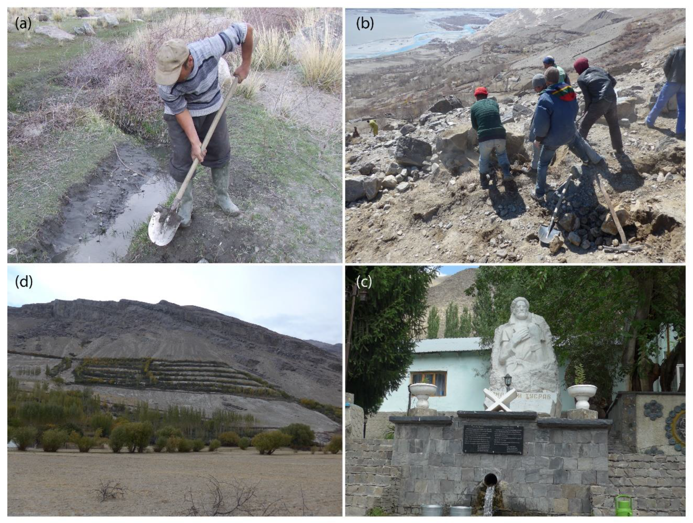
3.2. Autonomous Irrigation Arrangements of the Three Study Sites

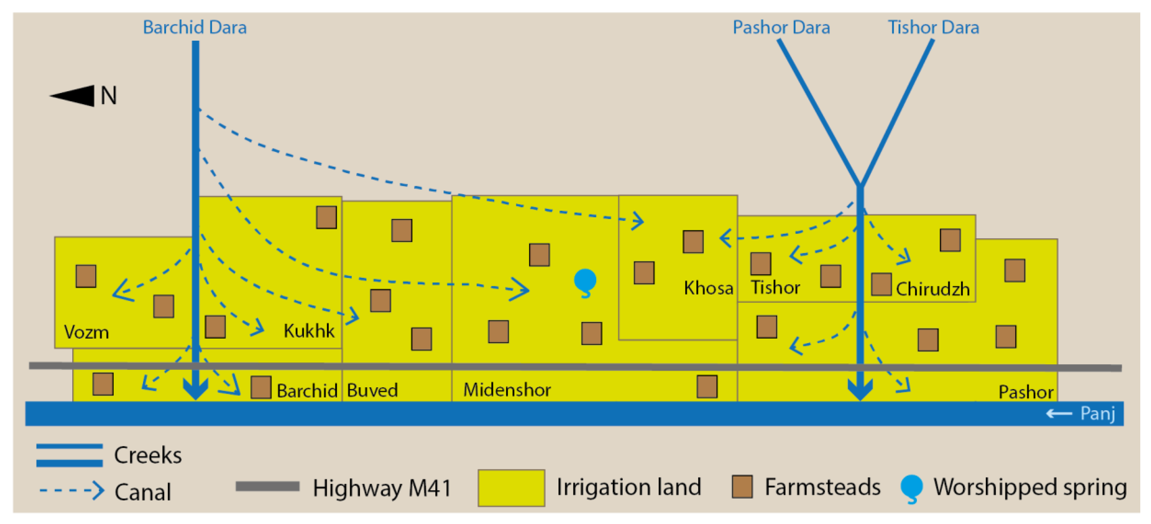
3.2.1. The Supralocal Water User Association of Porshnev Municipality

Irrigation agriculture within Porshnev Municipality historically relied on three natural creeks fed by snowmelt water, which are tapped by several canals that deliver water to the individual fields, orchards, and kitchen gardens of the local households. While both the creeks, named Tishor Dara and Pashor Dara, provide irrigation water from May until September to the four southern villages of Pashor, Chirudzh, Tishor, and Khosa, the largest of the three creeks, named Barchid Dara, provides irrigation water during the same time period to the six villages of Khosa, Midenshor, Buved, Barchid, Kukhk, and Vozm. A couple of smaller creeks flow for a short time after rain showers and snow melts but provide too little water to be substantial components of the supralocal irrigation arrangement of the jamoat of Porshnev. A small number of households receive water from the Panj River with the use of pumps [61,78,79,80], Figure 6.
According to local respondents, top–down regulations clearly defined that the fields of the state farm were prioritized and irrigated during the day during the socialist times. Private kitchen gardens could only receive water during night hours. Water theft was punished quickly and severely by the state. After the land privatization in the 1990s, instead, when each farmstead received an arable land plot according to the size of the respective household, conflicts over the order, time, duration of irrigation slots, and the amount of water withdrawn from the canals broke out between the farmers [60,79]. The head of the WUA told me during the group interview in the office of the organization that the “law of the jungle took over”, [61] meaning that water thievery, self-interest, and competition replaced regulated water use and cooperation in Porshnev. Households led by women, as well as isolated old and sick people, oftentimes emerged as losers from these discords, due to both their lower assertiveness and position within local hierarchies, as well as the absence of functioning authorities to implement an effective regulation that would guarantee equal access to irrigation water. The combination of the socioeconomic hardships of the post-socialist period mentioned in Section 2.3, spatiotemporal water scarcity, and the simultaneously growing number of people involved in irrigation affairs for subsistence agriculture required a locally developed answer to balance the interests of the stakeholders and to curtail the new irrigation-related conflicts. While the scarcity and spatially uneven distribution of irrigation water represented the most pressing environmental constraints for cultivation, the just and comprehensively satisfying allocation of irrigation water became one of the most important social tasks in the municipality of Porshnev at that time [61,71,80]. Local activists sought, through grassroots efforts, institutional support from the MSDSP to develop a just and inclusive mechanism to constructively handle the irrigation-related conflicts within the municipality. In this regard, several participatory assessment meetings were conducted to identify irrigation-related strengths and potentials, the most vulnerable groups, and the most pressing irrigation water-related challenges in Porshnev Municipality [61,71,81]. On these occasions, the physical components of the supralocal irrigation system were assessed and mapped, and older inhabitants were asked for their experiences and memories about historical approaches to irrigation management and practices [61,80,81].
The outcome of these grassroot efforts was the launch of a quickly growing WUA named “Ob Umed” (Water is hope) in 2009, which was serving nearly 9000 inhabitants of the municipality and had already over 1100 members (individual local households) paying a monthly membership fee of 1.00 TJS (0.10 USD) in 2018. Thus, with support from the MSDSP, the local activists used the legal requirements and provisions of the national law “On Water User Associations” as a framework for designing a local-specific irrigation management body adapted to the socio-ecological conditions in Porshnev [58,61,81,82].
The organizational structure of this WUA looks as follows. The coordination of the spatiotemporal water distribution between the villages is carried out by the water master (mirāb). Before implementation, these schedules have to be approved by the local administration of the municipality. To give an impression of how the spatiotemporal irrigation water allocation between the settlements of this study site looks like, the scheme for the Barchid Dara for the period of late spring–early summer is presented in Table 3. The distribution of irrigation water from this creek was such that each settlement mentioned above typically received a three-day irrigation slot with breaks of six days in between. In 2018, there was a ten-day break between the last irrigation slots in May and the first irrigation slot in June.
The water master is elected by the assembly of the canal masters (mirjuikho) for the duration of one year. In this regard, each of the nine settlements of the municipality delegates one mirjui to the assembly. The mirāb is assisted by an advisory body that consists of a congregation of the councils of village elders (muisafedon/aksaqalkho) from the nine settlements. The mirāb reports to the head (rais) of the WUA, who in turn has a so-called assembly of knowledgeable people (majlizi umumi) at his disposal to act as his advisory and arbitrating body. These positions historically, and today, have been held by men [61]. Regarding the allocation of irrigation water within the settlements, each settlement has its own internal scheme, as all settlements differ in terms of their physical endowment, the layout of farms and fields, and demographic features. These place-specific schedules are designed by the respective mirjuikho, which were, and continue to be, elected by the household representatives of the respective settlement for the duration of one year. Each mirjui gets advice from a local council of experienced and respected elder persons representing different neighborhoods of the respective settlements [61,80].
The fact that the water-related self-organization in Porshnev focuses not only on economic but also on cultural and social meanings of water is made clear by the fact that the WUA repaired and restored the holy spring named after Nazir-i Khuzraw (Figure 4c); that the organization decisively tackles the problem of having a reliable and fair drinking water supply in the municipality; and that the inhabitants of the villages use the organizational structure to convene collaborative work assignments at the neighborhood, village, and supralocal level, depending on the size of the task [21,61]. In order to support economically weak households and those who struggle with the labor shortage caused by the migration, sickness, or death of relative, a pilot project has recently created positions of jointly financed so-called “irrigators” (obshoron) at the village level. These individuals take over individual irrigation chores to support the respective households, which are often led by women [61]. These activities have gained notable international recognition: in 2014, the WUA was awarded the Equator Prize by the Equator Initiative of the United Nations Development Programme (UNDP) for its “best practice” activities for rural sustainable development [61,80]. From these locally informed insights, it becomes clear that the self-initiated supralocal organization addresses both several socio-ecological challenges outlined above with its activities and serves different meanings ascribed to water by the locals.

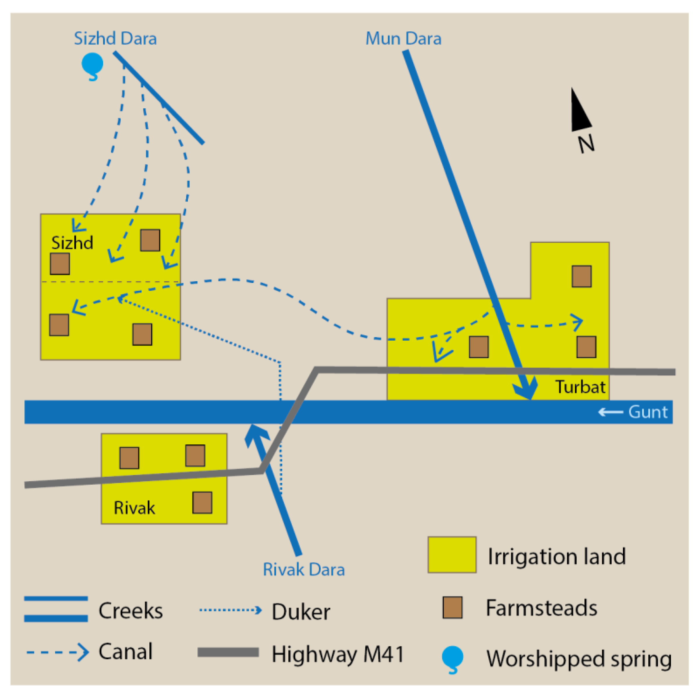
3.2.2. The Interlocal Irrigation Arrangement of Sizhd Village

Historically, the irrigation arrangement of Sizhd Village relied on two water sources fed by snowmelt: the local Sizhd Dara Creek originating from the Bibizainab Spring mentioned before, which runs down the hillside north of the village, and an approximately three-kilometer long interlocal canal channeling irrigation water from the neighboring side valley of the Mun Dara Creek, located to the east of Sizhd Village. Since 2002, a subterranean penstock pipe, which was constructed with the help of MSDSP and is locally known as “the duker”, withdraws water from the Rivak Dara Creek from the other side of the Gunt Valley to increase the irrigation water supply for the growing number of farmers at this study site [50,51,60,62]. Three rather small canals fed by the Sizhd Dara Creek usually provide irrigation water to the upper northern part of the settlement from May until the harvest in late summer, with a runoff peak in June and July. These canals can be used independently from other settlements. However, households that have their agricultural land in the upper part of Sizhd Village have repeatedly experienced the hardships of irrigation water scarcity due to the interplay of a growing number of water users in the area, a limited capacity of the water line caused by the detrimental effects of recurrent gravitational mass movements that cover parts of the creek, and a limited endowment of financial and technical means to pump irrigation water up from lower water bodies, such as the Gunt River or the mouth of the duker. The interlocal canal is instead considered to be the central water source of Sizhd Village. It has a larger capacity than the channels mentioned before and provides irrigation water from June until September to the lower southern part of the settlement using gravitational flow. Its water has to be shared with the settlement of Turbat though, which lies to the east of Sizhd. This requires coordinated water withdrawal to meet the irrigation demands of both settlements. The penstock empties into the main canal in the middle of the village for the benefit of the remaining downstream farmsteads. However, the farms located on the western edge of the village suffer the most from acute water shortages, especially after winters with low precipitation. Against this background, receiving a sufficient amount of irrigation water is, to a certain degree, up to the spatial location within the water supply system, since the current infrastructure favors upstream residents and the institutional arrangements are not able to fully compensate for this fact [51,60,62], Figure 7.
In terms of the local-specific irrigation arrangement, the main management responsibility rests with two canal masters. One is responsible for the upper part of the settlement, with nearly eighty households. The other is responsible for the lower part below the main canal, with an equal number of farmsteads receiving water from the Mun Dara Creek and the penstock pipe. Both mirjuikho are democratically elected by the inhabitants of the respective part of the village for one year and can be discharged when the performance they provide does not satisfy the recipients of the irrigation water. Both canal masters have to draft the irrigation schedules for the part of the settlement they are responsible for; to organize collaborative infrastructural maintenance activities that usually occur around the beginning of May, as well as for the collective cleaning of the duker in the fall; to define fines for breaching the set rules and schemes; and to mediate conflicts that arise [60,62]. Since a local water user association does not exist, they report directly to the village organization (VO) of Sizhd Village, which is a self-organized and participatory governance body that was initiated in Gorno-Badakhshan in 1998 by the MSDSP. The concept of the VOs in the Pamirs of Tajikistan is not an entirely new idea but is based on historical approaches of self-organization in the region and experiences made by the Aga Khan Rural Support Programme (AKRSP) in Northern Pakistan a decade prior [83,84]. This administrative body also acts as a formalized local link between the community and the official state administration.
When questions concerning the village arise, common meetings are announced in Sizhd. Every household dispatches one representative to participate in the discussions and public decision-making. According to local respondents, the most important water-related topics discussed during these meetings are infrastructure repair and maintenance works, possible extensions of the water supply system, and the payment schemes. In 2014, the mutually agreed price in the upper part of Sizhd for irrigating a hectare of land for twenty hours a month was a flat rate of 20.00 TJS (4.00 USD). In the lower part of the village, the lump sum was 15.00 TJS (3.00 USD) for irrigating a hectare of land for ten hours a month. The VO collects the irrigation fee from the farmers and forwards it to both canal masters as remuneration for their efforts [60,62].
Sizhd appeared to be the only one of the three studied cases in which irrigation water theft was brought up by local respondents without being specifically asked [50,60,62]. To fight the problem of water theft, the canal masters have set a procedure where first-time violators are obliged to pay a penalty of 15.00 TJS (3.00 USD in 2014) to the VO. The second breach of the rules for irrigation water withdrawal is punished with 100.00 TJS (20.20 USD), and a third violation will be reported to the police. This procedure is widely accepted and is considered to have a preventive character [51,60,62]. I interpret the proactive mentioning of irrigation water theft as indicating that it is an ongoing problem, especially for downstream abstractors, since they suffer the most from it. However, the existence of gradual sanctions and the respondents’ statements about the wide acceptance of this scheme are indications that a pragmatic approach has been found by the community to deal with this issue. Water-related collaborative activities and self-organization in Sizhd Village, thus, seem to focus primarily on the economic aspect of the agronomic importance of irrigation water for individual farming activities, as well as on disciplining unsocial behavior.

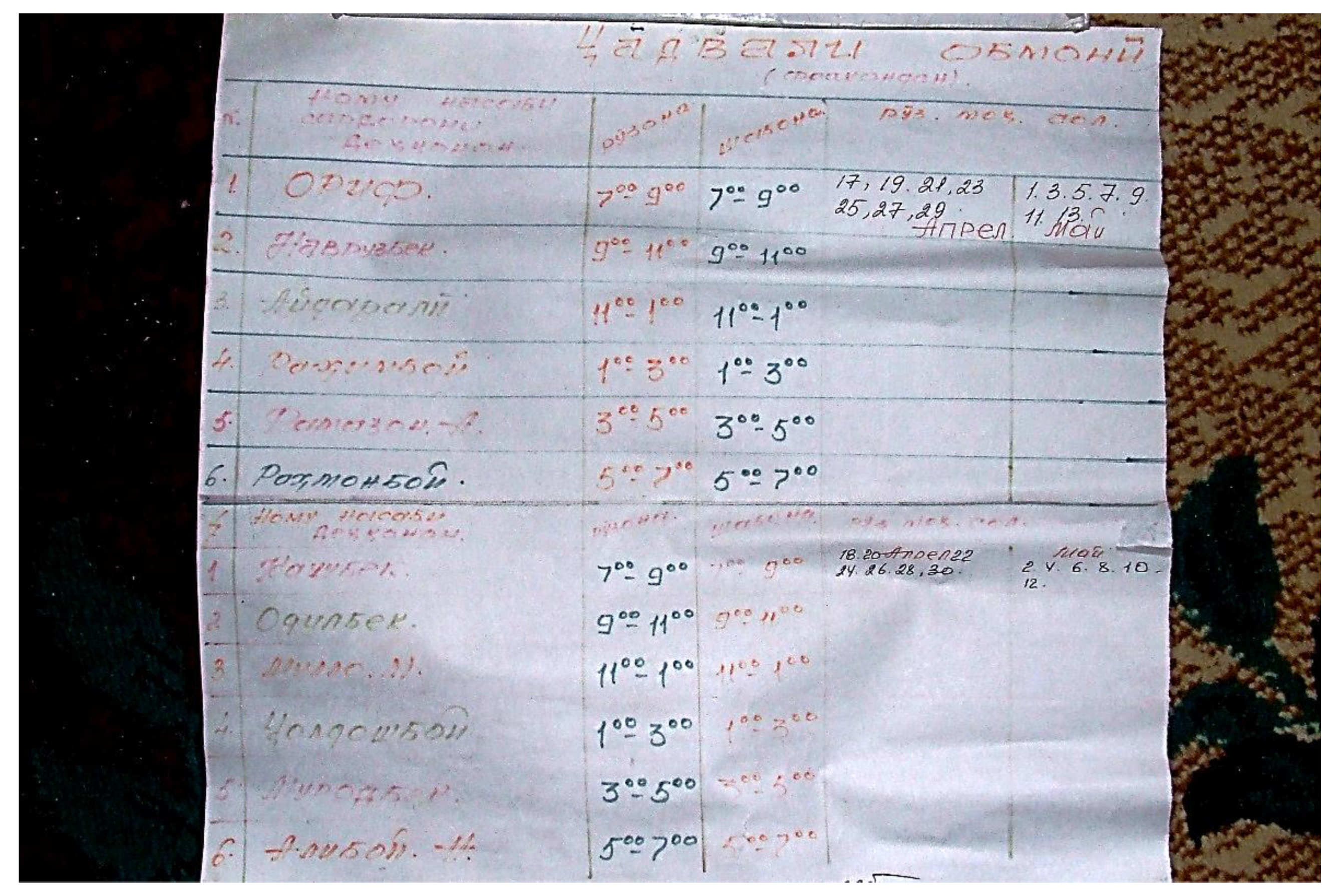
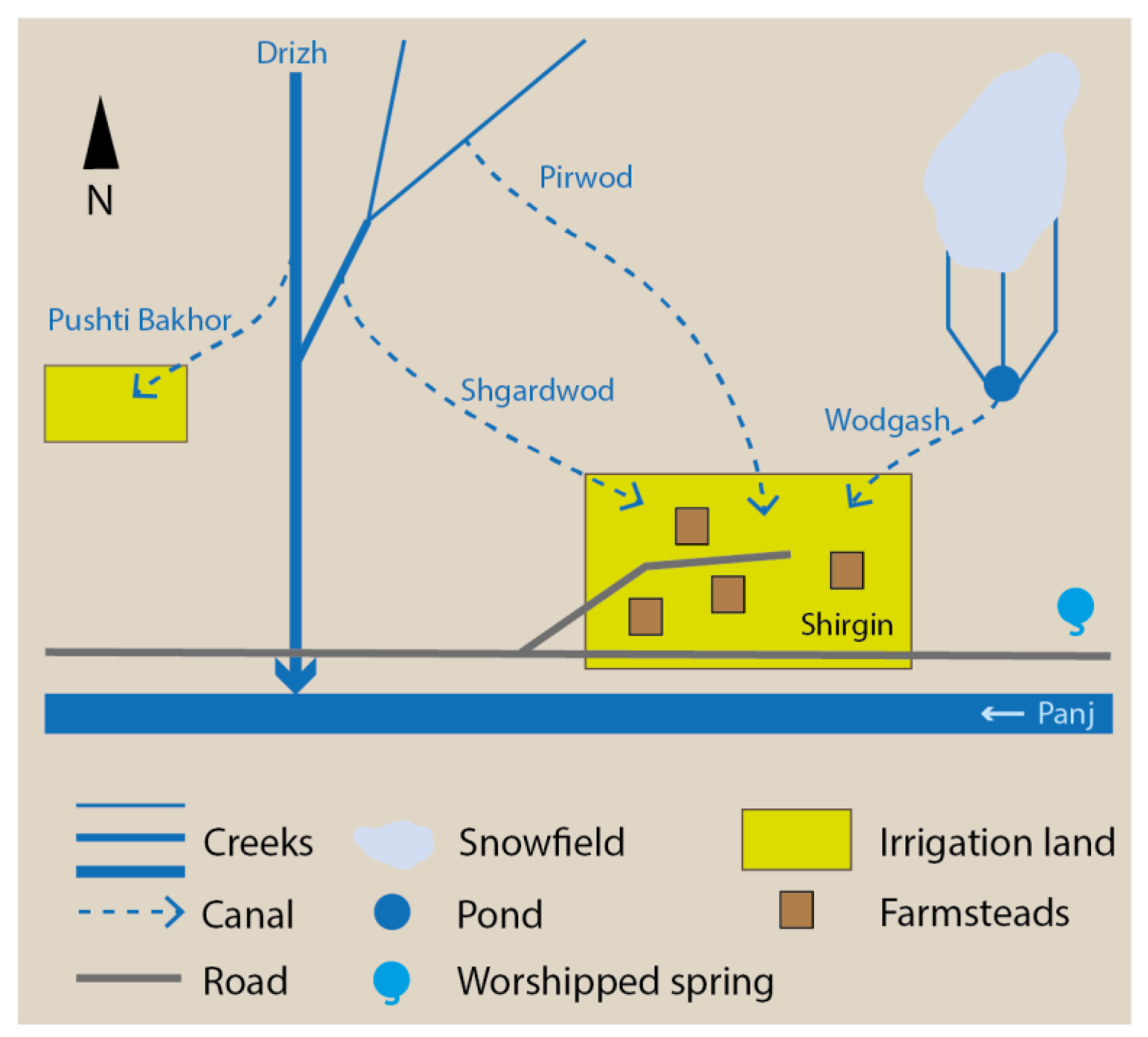
3.2.3. The Local Irrigation Arrangement of Shirgin Village

Due to the lack of water sources within the limits of the settlement, a technical structure for the delivery and distribution of irrigation water is required in Shirgin Village. Four main canals pipeline irrigation water from different sources to the land plots is cultivated by the villagers. The “Pirwod” is regarded to be the oldest canal, stemming from the early 19th century. It channels water coming from a glacier-fed creek from May until September using the natural gradient of a steep hill located to the north of the village. The small and short Wodgash Canal stems from a snow-fed natural pool and provides water from April to June to a couple of homesteads and land plots located in the eastern part of the village. Against the background of a growing population and the subsequently necessary extensions of arable land, a canal named Shgardwod, characterized by long concreted sections, was completed with technical support from the Russian Pamir Detachment in the early 20th century, which was securing the border to Afghanistan after finalizing the border delimitation agreement with Great Britain in 1895, according to local lore. Finally, the fields of a small high plateau called Late Spring (Pushti Bakhor), located outside of Shirgin to the West and used mainly for the cultivation of fodder crops, receive water from a canal that is fed by the Drizh Creek [54,55,59,76,77,84,85], Figure 8.
Over time, the community developed a sophisticated and autonomous arrangement to address the problem of the irregular and spatiotemporally uneven water supply. Against the background that an overarching institution governing local water issues does not exist, the village assembly (majliz) became the major decision-making body. It gathers annually around the time of the Navruz Festival. The assembly consists of the elected head of the village, respected village elders and spiritual leaders, and representatives of the village’s women and youth group, as well as the heads of the individual households of Shirgin Village. At this annual occasion, the majliz elects and appoints the mirāb, who is responsible for securing the water supply through supervising the main canals [54,55,57,59,76]. When the mirāb identifies infrastructural problems during his daily inspections, he announces a day of collective work. This often occurs in late winter, early spring, and after damages from rockfalls and landslides during the vegetation period. The maintenance regime for the Shgardwod Canal is organized differently. Each household that receives water from this canal is responsible for a specific section of approximately 30 to 50 m in length and has to conduct small cleaning and repair jobs independently to insure the functionality of this irrigation water supply line [59,76]. The water master is also responsible for the creation of irrigation schedules adapted to different stages of the cultivation period and the amount of available water. These schedules have to be accepted by the village assembly. The mirāb receives an annual remuneration of 10.00 TJS (1.30 USD in 2016) from each household, which makes an annual income of approximately 1000.00 TJS (130.00 USD). Payments calculated on the size or location of land, such as those seen in Sizhd Village, do not exist [54,55,59]. Low payment morale and irrigation water theft are not significant problems in Shirgin Village. According to the water master, the head of the village, and a teacher, there are usually only a few defaulters on the payment of the annual fee, and despite water shortages, the local farmers adhere to the jointly agreed water distribution regulations [57,59,84].
In alignment with the gravitational flow of the water, so-called heads of farmers (sardorkho-i dekhqonon) are one management level below the water master. They are responsible for the supervision and the handling of the locks blocking the six secondary canals within the village limits, as well as for the condition of the canals themselves. In this respect, they perform a role that corresponds to that of the mirjuikho of Porshnev Municipality and Sizhd Village. Each secondary canal has four heads that take turns and represent a different subgroup of farmers using the same secondary canal. The sardorkho-i dekhqonon are elected by their group and are responsible for water withdrawal according to the agreed upon schedules. The spatiotemporal water division within these subgroups is negotiated internally. The arrangements are very flexible to quickly address changing water availabilities due to weather changes or damages of the infrastructure. Individual farmers handling the water distribution on their private plots can be seen as the fifth, and final, tier of this autonomous irrigation arrangement [24,54,59,84].
Finally, different irrigation schedules adapted to different scenarios in terms of two different stages of the cultivation period and the amount of available water are briefly outlined. The first schedule is used during the beginning of the cultivation period from the middle of April until mid-May in years with an average water supply. All farmers of the village are allocated to two main groups, each consisting of six subgroups of up to ten households. The six subgroups belonging to the first main group are entitled to irrigate their fields on odd calendar dates, the second main group on even dates. The irrigation entitlement of a group comprises a day irrigation round lasting from 7am to 7pm, and a night irrigation round lasting from 7pm until 7am the next morning. Accordingly, every subgroup has the right to irrigate their fields for two hours during the day and two hours during the night. The water distribution within the subgroup is negotiated by its members (Figure 5). A second schedule is used from the middle of May until the main harvest in August. Every neighborhood receives irrigation rights valid for one specific day of the week. Within the neighborhoods, the neighbors organize the water distribution themselves. In summers with serious water scarcity, the canal-specific subgroups mentioned before receiving 24-h-long irrigation rights, have to negotiate the water distribution within their groups independently. When the water shortage is severe, the time slot for irrigation can be shortened to less than one hour duration per beneficiary [24,54,59,84].
In my understanding, the water-related activities and self-organization of the community of Shirgin Village, such as in the other two case studies, primarily refer to the economic meaning of water. Based on an egalitarian principle, this autonomous irrigation arrangement provides all households with as equal an access as possible to irrigation water for subsistence agriculture in a situation characterized by acute water scarcity. Through collaborative activities, divided maintenance responsibilities for one of the main canals, and the involvement of many households representatives in the overall management arrangement (1 water master, 24 canal masters, and an unknown number of persons involved in water distribution within the subgroups of farmers), the water-related social meanings of common ownership of, and shared responsibility for, a community property is also given special consideration. The worshipped spring, instead, is not the subject of joint efforts at the village level but is maintained by a group of young activists interested in improving the living conditions in the village and promoting Shirgin’s attractiveness to external visitors [75].

4. Discussion

The presented results show that water plays a key role in the lifeworld, everyday life activities, livelihood strategies, collaborative resource management arrangements, and the local-specific form of autonomous social organization of the people inhabiting the rural areas of the arid mountain region of the Western Pamirs. Common features of the three case studies are a similar historical past and similar socio-ecological challenges, including demographic growth, spatial and temporal unequal distribution and scarcity of water, and agricultural practices dependent on it. Likewise, all three studied irrigation arrangements primarily address economic and social meanings of water. However, there also are significant differences in the administrative scope and legal status of each irrigation arrangement, the number of beneficiaries, the degree of involvement of the population in the management structures and practices, and the problem of water theft (Table 2). These aspects are discussed in the following paragraphs.
Agriculture in the study area presupposes the existence of a functioning technical irrigation infrastructure; the operation, maintenance, and development of which is associated with considerable and individually insurmountable costs. By means of local self-organization, collective structures were created in all three study sites to replace the former state farms and take over the control of the respective irrigation arrangement. Based on local knowledge and, as in the case of Porshnev, also on external expertise, bottom–up initiatives developed management systems and water distribution schemes that are adapted to the changed social conditions. These collective arrangements, based on cost sharing mainly in terms of shared management responsibilities and collaborative actions, enable the people to practice individual irrigation farming. By establishing, enforcing, and monitoring balanced and widely accepted water distribution schemes, the general problems of scarcity and unequal spatiotemporal distribution of the resource is addressed. For those persons who are entrusted with management responsibilities on a full-time basis, as in the leadership of the WUA of Porshnev Municipality, or on a voluntary basis, as in Sizhd and Shirgin, there are also positive monetary effects in the form of collectively born wages or fees. Autonomous irrigation arrangements, thus, address crucial economic meanings of water and enable the exercise of irrigation agriculture representing a basic component of the livelihood strategies of many rural households in a context of very limited non-agricultural income opportunities in the Western Pamirs.
The collaborative work on irrigation infrastructures in all three study sites also addresses social aspects of water and often focuses on aspects of its ecological significance by being called up after events damage infrastructure. In this regard, irrigation infrastructure-related collaborative action initiated by bodies of local social organization is a response to the challenge of the vulnerability of irrigation infrastructures to physical damage caused by natural forces. With the broad anchoring of management responsibilities in the local communities, especially in Shirgin Village and Porshnev Municipality, an effective system of control and collective ownership of the irrigation system seems to be associated with an effective prevention of water theft. Sizhd Village differs in that way that within the village there are considerable disparities in the irrigation water supply that are partly attributed to water theft. However, the locally accepted institution of gradual sanctions is perceived as an effective preventive instrument and can be understood in Ostrom’s sense as one of the design principles of “long-enduring common pool resources (CPR)” [86] (p. 90).
One of the central characteristics of the autonomous social organization approach around water in Porshnev Municipality is the fact that it is based on a formal national legal regulation that defines the basic requirements, components, and working principles for WUAs as a legal person and translates these regulations and principles into local management practices. This supralocal autonomous irrigation arrangement includes regulations for determining the head of the organization and other owners of administrative function; procedural aspects such as elections and collaborative irrigation infrastructure construction, repair, and maintenance works, as well as channels and interfaces for direct communication with the communities at all involved levels such as the advisory panels at both the local and supralocal level to deliberately allocate and regulate responsibilities and accountability. The other key aspect is that the WUA of the Porshnev Municipality was not a top–down implemented project as seen in as many other places in Central Asia [87,88] but originated from the grassroots efforts of local activists. Last but not least, as problem definition and suggestions for new activities have to come from the users themselves, this supralocal social organization around water highly depends on the active engagement, participation, and cooperation of the inhabitants in water resource governance and management activities.
According to the WUA leadership in Porshnev Municipality, this approach has proven to be successful since the settlements effectively cooperate with each other, share labor, time, and other costs and, so far, have managed to solve conflicts over irrigation water without the involvement of external state actors [61,80,82]. This positive interpretation is challenged by Shabdolov, who refers to his own observations and complaints from local water users about recurring violations of regulations commonly agreed upon, water theft, and the unsatisfying execution of sanctions. However, the author also reports that “in most of the cases conflict participants together with (canal masters) have managed to mediate the struggles by referring to formal authorities and appealing to traditions, religion and brotherhood” [79] (p. 18). Finally, the new obshoron approach attempts to help needy households in the area of irrigation work, which is essential for their survival. Other aspects that support my assessment that this autonomous irrigation arrangement, which successfully blends formal and informal institutional aspects to a local-specific hybrid resource management approach that appears to be a sustainable and robust form of supralocal social organization, is the fact that it has been awarded the Equator Prize by the Equator Initiative of the UNDP and recognized as one of the ”best practices” for equitable community-based water management and local governance. Representatives of the organization conduct training sessions on water management based on their experiences for interested organizations not only in the GBAO, but also in other regions of Tajikistan and Afghanistan [21,61]. The situation is different in Sizhd Village. There are several factors that seem to contribute to recurring cases of water theft reported by the respondents in this village: a generally insufficient quantity of irrigation water and its spatially uneven distribution; limited non-agricultural income opportunities and a wide reliance on subsistence cultivation to make a living; limited financial assets to afford technical equipment such as construction machinery to clean the streambed of the Sizhd Dara Creek, the only local water source, as well as pumps to convey irrigation water from lower water bodies such as the Gunt River to upper parts of the settlements; and finally, a rising number of farmsteads and water users due to a growing population. Interestingly, water theft has not been mentioned by respondents from the other two study sites as being a frequent and potentially serious threat to the respective local irrigation arrangement. However, it is notable that the respondents stated that they accept the current irrigation system the way it is, and that the concept of gradual sanctions is perceived as an effective instrument to prevent water theft. Looking at the community of Sizhd Village through the prism of water helps to uncover otherwise possibly invisible features of both the social organization and spatial division of a community in terms of access to the existential resource of irrigation water, on the one hand, and on the other hand, a local-specific approach mutually agreed upon to handle water-related misbehavior. Finally, I conclude that the local irrigation arrangement of Shirgin Village represents a functional common resource management approach and form of independent social organization, which includes joint decision-making, sharing of both the benefits and burdens, collaborative action, the division of management responsibilities among many farmers, and prevention of free riding and water theft through social control. This assessment is based on several arguments. First, five knowledgeable persons, including individual farmers, local leaders, and people involved in irrigation water management, explicitly regarded the distribution system of irrigation water as equitable [55,57,75,76,77]. Second, the arrangement reliably provides irrigation water, enabling the local cultivation of food and fodder plants for many years and, thereby, contributes to achieving the goal of food security at the local level. Third, the approach is flexible and differentiated enough to successfully balance different cultivation-related interests within the user community and to adapt quickly to the shifting availability of irrigation water caused by weather changes and damage to the irrigation infrastructure. Thereby, this local-specific solution promotes the survival of individual households under the current challenging social and ecological conditions mentioned above. Other important reasons for the almost frictionless performance seem to be that water access rights are barely contested within the settlement itself and the fact that the irrigation water consumed by the inhabitants of Shirgin Village is not shared with other settlements; thus, it can be autonomously deployed. The broad involvement of the community in irrigation water management and the system’s adaptability appear to be pivotal factors for its sustainability and resilience to the challenging socio-ecological conditions of the region.

5. Conclusions

The presented autonomous irrigation arrangements in the three study sites represent highly differentiated and socio-ecologically contextualized solutions, which were initiated from the bottom–up and developed by the communities themselves. I conclude that the longevity of the presented arrangements suggests that they are widely accepted by the respective populations, quite well-adapted to the respective local setting, and flexible enough to respond to shifting conditions. The particular strength of the presented cases seems to lie in several social assets shared by the community members, such as situated local knowledge; the acceptance of clearly defined management structures within widely participatory decision-making; and coordinated collaborative action and sharing of benefits and burdens. Instead of being based on the logic of the market, the principles of cooperation and mutual support are characteristic of the irrigation arrangements. They promote a kind of micro-scale “hydrosolidarity” [89] among the respective water user community members. Together, these features lead to the reduction in individual risks and living costs, as well as decrease free-riding through social control, if not its full eradication. Consequently, collective acceptance of, and identification with, local irrigation arrangements have developed.
At the same time, however, local social organization efforts also face several limitations. The case of Sizhd Village, for instance, shows the limitations autonomous resource management approaches are facing. The challenges that cannot be addressed solely by local efforts, include, amongst others, the acquisition of expensive technical solutions for delivering water from other sources; the structural improvement of the limited wage work opportunities in the village to diversify the livelihoods of the people and make them less dependent on irrigation cultivation; and a stronger integration of the region into national and international market networks. This is where external assistance remains necessary, when requested by the communities.
Irrigation governance and management has been studied by numerous scientists from many disciplines, applying diverse perspectives and emphasizing different aspects such as the impacts of institutional change on irrigation governance [90], nature-related transactions and governance structures [91], and the role of gender and authority in collective irrigation systems [39,92], to mention just a few. This paper instead looks from an inductive, bottom–up perspective at small-scale autonomous irrigation arrangements through the prism of water, conceptualized as a so-called “nexus medium”. On the one hand, the approach is characterized by an emic mindset that attempts to understand the issue from the perspective of local communities and their members. This is linked to the attempt to contribute to the growing pool of approaches that aim at decolonizing knowledge production in, and about, the Global South (and East). On the other hand, the approach opposes the modernization theory-informed view that compartmentalizes research subjects with an integrative approach and considers them in their ambiguity. The detailed results underline the potential of open-ended qualitative ethnographic research approaches for the study of common pool resources, collaborative action, and social organization. It also shows that the nexus medium concept is an appropriate approach for studying social processes and human–environment relations at the local scale, particularly where a resource itself, or a resource management approach, can be considered as being a common pool resource. The application of the perspective does not seek solutions for already identified problems; it aims instead to understand the phenomena and processes at the local level with explicit consideration of the perceptions and assessments of the local people, as well as the corresponding social and ecological contexts. Applying this perspective can provide contextualized insights about the potentials, performances, guiding principles, and limitations of common pool resource management approaches not only in the remote high mountain regions of Central Asia, but also beyond. This is one of the possible added values of the approach compared to the deductive nexus approaches criticized at the beginning. However, the paper does not want to play the two perspectives off against each other. Rather, I see them as complementary, and think that a combined application of both perspectives to a research question can lead to both a new avenue of study and mutually informed insights, which remain hidden if just one perspective is applied.

Funding

Research for this study was kindly supported by the German Federal Ministry of Education and Research (Grant: 01DK15010), the University Alliance for Sustainability (Senior Researcher Scholarship); the Geo.X—The Research Network for Geosciences in Berlin and Potsdam (Outgoing Geo.X Travel Award); and the Centre for Development Studies of the Freie Universität Berlin. Financial and practical support is highly acknowledged. The publication of this article was funded by Freie Universität Berlin.

Acknowledgments

Many local residents shared their knowledge of environmental conditions, institutions, and customs, as well as the local terminology utilized in the study region. The names of interview partners have been changed or omitted to ensure anonymity. I would also like to thank Mary Elizabeth Wilson for reviewing earlier drafts and the reviewers for their valuable comments. Practical support is highly acknowledged.

Conflicts of Interest

The author declares no conflict of interest. The funders had no role in the design of the study; in the collection, analyses, or interpretation of data; in the writing of the manuscript; or in the decision to publish the results.

References

  1. Bleischwitz, R.; Spataru, C.; VanDeveer, S.; Obersteiner, M.; van der Voet, E.; Johnson, C.; Andrews-Speed, P.; Boersma, T.; Hoff, H.; van Vuuren, D.P. Resource nexus perspectives towards the United Nations Sustainable Development Goals. Nat. Sustain. 2018, 1, 737–743. [Google Scholar] [CrossRef] [Green Version]
  2. Bizikova, L.; Roy, D.; Swanson, D.; Venema, H.D.; McCandless, M. The Water–Energy–Food Security Nexus: Towards a Practical Planning and Decision-Support Framework for Landscape Investment and Risk Management, 1st ed.; The International Institute for Sustainable Development: Winnipeg, MB, Canada, 2013. [Google Scholar]
  3. Nexus. Nexus in Central Asia. European Union Supports Investment to Foster Water, Energy and Food Security in Central Asia. Available online: https://www.water-energy-food.org/news/nexus-in-central-asia-european-union-supports-investment-to-foster-water-energy-and-food-security-in-central-asia/ (accessed on 10 July 2020).
  4. Bazilian, M.; Rogner, H.; Howells, M.; Hermann, S.; Arent, D.; Gielen, D.; Steduto, P.; Mueller, A.; Komor, P.; Tol, R.S.J.; et al. Considering the Energy, Water and Food Nexus: Towards an Integrated Modelling Approach. Energy Policy 2011, 39, 7896–7906. [Google Scholar] [CrossRef]
  5. Hussey, K.; Pittock, J. The Energy-Water Nexus: Managing the Links between Energy and Water for a Sustainable Future. Ecol. Soc. 2012, 17, 31. [Google Scholar] [CrossRef]
  6. Abdullaev, I.; Rakhmatullaev, S. Setting up the Agenda for Water Reforms in Central Asia: Does the Nexus Approach Help? Environ. Earth Sci. 2016, 75, 870. [Google Scholar] [CrossRef]
  7. Rasul, G.; Sharma, B. The Nexus Approach to Water–Energy–Food Security: An Option for Adaptation to Climate Change. Clim. Policy 2016, 16, 682–702. [Google Scholar] [CrossRef] [Green Version]
  8. Bleischwitz, R.; Hoff, H.; Spataru, C.; van der Voet, E.; VanDeveer, S.D. (Eds.) The Resource Nexus. Preface and Introduction to the Routledge Handbook. In Routledge Handbook of the Resource Nexus, 1st ed.; Routledge: London, UK, 2018; pp. 3–14. [Google Scholar]
  9. Gesellschaft für Internationale Zusammenarbeit (GIZ) GmbH. Programme: Nexus—Water, Energy and Food Security for Bolivia. German Development Cooperation Supports the Integration and Systematic Implementation of Multi-Sectoral Development Measures; GIZ: La Paz, Bolivia, 2017. [Google Scholar]
  10. Food and Agricultural Organization of the United Nations. The Water-Energy-Food Nexus. A New Approach in Support of Food Security and Sustainable Agriculture, 1st ed.; FAO: Rome, Italy, 2014. [Google Scholar]
  11. Zahner, A.; Renewable Energy & Energy Efficiency Partnership (REEEP). Making the Case: How Agrifood Firms Are Building New Business Cases in the Water-Energy-Food Nexus, 1st ed.; REEEP, Food and Agricultural Organization of the United Nations: Vienna, Austria; Rome, Italy, 2014. [Google Scholar]
  12. Brears, R.C. (Ed.) The Green Economy and the Water-Energy-Food Nexus, 1st ed.; Palgrave Macmillan: London, UK, 2018. [Google Scholar]
  13. Church, M.; Mark, D.M. On Size and Scale in Geomorphology. Prog. Phys. Geogr. 1980, 4, 342–390. [Google Scholar] [CrossRef]
  14. Kreutzmann, H. (Ed.) Water Towers of Humankind: Approaches and Perspectives for research on Hydraulic Resources in the Mountains of South and Central Asia. In Sharing Water. Irrigation and Water Management in the Hindukush, Karakoram, Himalaya, 1st ed.; Oxford University Press: Karachi, Pakistan, 2000; pp. 13–31. [Google Scholar]
  15. Fourniau, V. Some Notes on the Contribution of the Study of Irrigation to the History of Central Asia. In Sharing Water. Irrigation and Water Management in the Hindukush, Karakoram, Himalaya, 1st ed.; Kreutzmann, H., Ed.; Oxford University Press: Karachi, Pakistan, 2000; pp. 32–54. [Google Scholar]
  16. Mukhiddinov, I. Zemledelie Pamirskikh Tadzhikov Vakhana i Ishkashima v XIX-Nachale XX v. (Istoriko-Etnograficheskii Ocherk), 1st ed.; Izd. Nauka; Glavnaya Redakciya Vostochnoi Literatury: Moskva, Soviet Union, 1975. [Google Scholar]
  17. Mukhiddinov, I. Osobennosti Tradicionnogo Zemledel’cheskogo Khozyaistva Pripamirskikh Narodnostei v XIX—Nachale XX Veka, 1st ed.; Izd. Nauka; Glavnaya Redakciya Vostochnoi Literatury: Moskva, Soviet Union, 1984. [Google Scholar]
  18. Koen, B.D. Beyond the Roof of the World: Music, Prayer, and Healing in the Pamir Mountains, 1st ed.; Oxford University Press: New York, NY, USA, 2009. [Google Scholar]
  19. Netting, R.M. The System Nobody Knows. Village Irrigation in the Swiss Alps. In Irrigation’s Impact on Society, 1st ed.; Downing, T.E., Gibson, M., Eds.; University of Arizona Press: Tucson, AZ, USA, 1974; pp. 67–75. [Google Scholar]
  20. Kreutzmann, H. (Ed.) Israr-ud-din. Social Organization and Irrigation Systems in the Khot Valley, Eastern Hindukush. In Sharing Water. Irrigation and Water Management in the Hindukush, Karakoram, Himalaya, 1st ed.; Oxford University Press: Karachi, Pakistan, 2000; pp. 55–72. [Google Scholar]
  21. WUA OU Water User Association Ob Umed. Informacionnyi Bulleten’ (Different Editions). Available online: http://obumed.org/index.php/publications (accessed on 1 August 2019).
  22. Hajek, A.; Davis, A. Oral History. In International Encyclopedia of the Social & Behavioral Sciences, 1st ed.; Wright, J.D., Ed.; Elsevier: Oxford, UK, 2015; pp. 284–290. [Google Scholar] [CrossRef]
  23. Dörre, A. Local Knowledge-Based Water Management and Irrigation in the Western Pamirs. Int. J. Environ. Impacts 2018, 1, 254–266. [Google Scholar] [CrossRef]
  24. Dörre, A.; Goibnazarov, C. Small-Scale Irrigation Self-Governance in a Mountain Region of Tajikistan. Mt. Res. Dev. 2018, 38, 104–113. [Google Scholar] [CrossRef]
  25. Bernard, H.R. (Ed.) Field Notes: How to Take Them, Code Them, Manage Them. In Research Methods in Anthropology. Qualitative and Quantitative Approaches, 4th ed.; Altamira Press: Lanham, MD, USA; New York, NY, USA; Toronto, ON, Canada; Oxford, UK, 2006; pp. 387–412. [Google Scholar]
  26. Schreier, M. Qualitative Content Analysis. In The SAGE Handbook of Qualitative Data Analysis, 1st ed.; Flick, U., Ed.; SAGE: Los Angeles, CA, USA; London, UK; New Delhi, India; Singapore; Washington, DC, USA, 2014; pp. 170–183. [Google Scholar]
  27. Geertz, C. (Ed.) Thick Description: Toward an Interpretive Theory of Culture. In The Interpretation of Cultures, 1st ed.; Basic Books: New York, NY, USA, 1973; pp. 3–30. [Google Scholar]
  28. Miehe, G.; Winiger, M.; Böhner, J.; Yili, Z. The Climatic Diagram Map of High Asia. Purpose and Concepts. Erdkunde 2001, 55, 94–97. [Google Scholar] [CrossRef]
  29. Xenarios, S. Climate Change and Adaptation of Mountain Societies in Central Asia: Uncertainties, Knowledge Gaps, and Data Constraints. Reg. Environ. Chang. 2018, 19, 1339–1352. [Google Scholar] [CrossRef]
  30. Water Systems Analysis Group, UNH University of New Hampshire. Meteorological Station Data, Horog. 2010. Available online: http://neespi.sr.unh.edu/cgi-bin/station/meteo_station.pl?id=38954 (accessed on 27 July 2020).
  31. Water Systems Analysis Group, UNH University of New Hampshire. Meteorological Station Data, Ishkashim. 2010. Available online: http://neespi.sr.unh.edu/cgi-bin/station/meteo_station.pl?id=38957 (accessed on 27 July 2020).
  32. Jarvis, A.; Reuter, H.I.; Nelson, A.; Guevara, E. Hole-Filled Seamless Srtm Data V4. Tile 51–5. 2008. Available online: http://srtm.csi.cgiar.org/ (accessed on 11 May 2015).
  33. OSM Open Street Map. Open Street Map. 2017. Available online: https://www.openstreetmap.org (accessed on 3 May 2017).
  34. Olufsen, O. Through the Unknown Pamirs. The Second Danish Pamir Expedition 1898–99, 1st ed.; William Heinemann: London, UK, 1904. [Google Scholar]
  35. Andreev, M.S.; Polovcev, A.A. Materialy po Etnografii Iranskikh Plemen Srednei Azii. Ishkashim and Vakhan, 1st ed.; Tipografiya Imperatorskoi Akademii Nauk: St. Petersburg, Russia, 1911. [Google Scholar]
  36. Saidov, M.; Ischuk, N. Natural Hazards in Tajikistan; OSCE: Dushanbe, Tajikistan, 2016.
  37. Kraudzun, T. From the Pamir Frontier to International Borders: Exchange Relations of the Borderland Population. In Subverting Borders. Doing Research on Smuggling and Small-Scale Trade, 1st ed.; Bruns, B., Miggelbrink, J., Eds.; VS Verlag für Sozialwissenschaften: Wiesbaden, Germany, 2011; pp. 171–191. [Google Scholar]
  38. Kreutzmann, H. Pamirian Crossroads. Kirghiz and Wakhi of High. Asia, 1st ed.; Harrassowitz: Wiesbaden, Germany, 2015. [Google Scholar]
  39. Bossenbroek, L.; Zwarteveen, M. Irrigation Management in the Pamirs in Tajikistan: A Man’s Domain? Mt. Res. Dev. 2014, 34, 266–275. [Google Scholar] [CrossRef]
  40. Anderson, K.; Pomfret, R. Consequences of Creating a Market. Economy. Evidence from Household Surveys in Central Asia, 1st ed.; Edward Elgar: Cheltenham, UK; Northampton, MA, USA, 2003. [Google Scholar]
  41. Dudwick, N.; Gomart, E.; Marc, A.; Kuehnast, K. (Eds.) From Soviet Expectations to Post-Soviet Realities: Poverty during the Transition. In When Things Fall Apart: Qualitative Studies of Poverty in the Former Soviet Union; The World Bank: Washington, DC, USA, 2003; pp. 21–27. [Google Scholar]
  42. Bliss, F. Social and Economic Change in the Pamirs (Gorno-Badakhshan, Tajikistan), 1st ed.; Routledge: London, UK; New York, NY, USA, 2006. [Google Scholar]
  43. Robinson, S.; Guenther, T. Rural Livelihoods in Three Mountainous Regions of Tajikistan. Post-Communist Econ. 2007, 19, 359–378. [Google Scholar] [CrossRef]
  44. Serebrennikov, A.G. Ocherk Shugnana (S Kartoyu), 1895. In File 74/1/2; Archive of the Russian Geographical Society: St Petersburg, Russia, 1895. [Google Scholar]
  45. Baranov, P.A. Pamir i Ego Zemledel’cheskoe Osvoenie, 1st ed.; Gosudarstvennoe Izdatel’stvo Kolkhoznoi i Sovkhoznoi Literatury: Moskva, Soviet Union, 1940. [Google Scholar]
  46. Bubnova, M.A. Gorno-Badakhshanskaya Avtonomnaya Oblast’. Zapadnyi Pamir (Pamyatniki 2 tys. do n. e.—XIX v.), 1st ed.; Donish: Dushanbe, Tajikistan, 1997. [Google Scholar]
  47. GKTS Gosudarstvennyi Komitet Tadzhikskoi SSR po Statistike. Gorno-Badakhshanskaya Avtonomnaya Oblast‘ v Cifrakh v 1987 godu, 1st ed.; GOSKOMSTAT TaSSR: Dushanbe, Soviet Union, 1988. [Google Scholar]
  48. Herbers, H. Postsowjetische Transformation in Tadschikistan: Die Handlungsmacht der Akteure im Kontext von Landreform und Existenzsicherung, 1st ed.; Fränkische Geographische Gesellschaft: Erlangen, Germany, 2006. [Google Scholar]
  49. HSA PRT Head of the Statistical Agency under the President of the Republic of Tajikistan. Report on the Number of Households and Population in Rural Areas to 2015; HSA PRT: Dushanbe, Tajikistan, 2015.
  50. Parvonov, P.; Former clerk, state farm ‘Vatan’, Sizhd Village, Tajikistan. Personal communication, 2014.
  51. Khudomunov, K.; Former water master, state farm ‘Vatan’, Sizhd Village, Tajikistan. Personal communication, 2014.
  52. Snesarev, A.E. Statisticheskie Svedenie o Pravom Berege Reki Pyandzha v Uchastke Lyangar–Namadgut. In File 115/1/128; Archive of the Institute of Oriental Manuscripts of the Russian Academy of Sciences: St Petersburg, Russia, 1902. [Google Scholar]
  53. UNKhU Upravlenie Narodno-Khozyaistvennogo Uchyota Tadzhikskoi SSR, Sektor Uchyota Naseleniya i Kult’tury. Spisok Naselyonnykh Punktov TadzhSSR, 1st ed.; UNKhU: Stalinabad, Soviet Union, 1932. [Google Scholar]
  54. Mudoyorov, K.; Former teacher; expert on local history, Shirgin Village, Tajikistan. Personal communication, 2015, 2016.
  55. Deronov, S.; Teacher, farmer, Shirgin Village, Tajikistan. Personal communication, 2016.
  56. ADC Austrian Development Cooperation; PAMIR Poverty Alleviation by Mitigation of Integrated High-Mountain Risk; FOCUS; Humanitarian Assistance, Hilfswerk Austria International. Nakshai Idorakunii Ofatkhoi Tabii. Dekhai Shirgin–Dzhamoati Vrang–Nokhiyai Ishkoshim; ADC: Khorog, Tajikistan, 2013. [Google Scholar]
  57. Maklabekov, B.; Head of village, farmer, Shirgin Village, Tajikistan. Personal communication, 2016.
  58. WUA OU Water User Association Ob Umed. Nasha Deyatel’nost’ v Cifrakh. 2018. Available online: http://obumed.org/index.php (accessed on 3 October 2020).
  59. Khirzoev, M.; Former farm manager and water master state farm “Lenin”; water master,, Shirgin Village, affiliation, city, Tajikistan. Personal communication, 2015, 2016.
  60. Mishkhonov, A.; Canal master, Sizhd Village, Tajikistan. Personal communication, 2014.
  61. WUA OUA Administration of the Water User Association Ob Umed; Porshnev Municipality, Midenshor Village, Tajikistan. Personal communication, 2018.
  62. Füssel, G.; Kaikovusova, G.; Schaddenhorst, H.; Sabzaliev, T. Understanding Community-Managed Hill Irrigation Systems in the Tajik Pamirs; Freie Universitaet Berlin, Centre for Development Studies: Berlin, Germany, 2014. [Google Scholar]
  63. Mukhamedova, N.; Wegerich, K. The Feminization of Agriculture in Post-Soviet Tajikistan. J. Rural Stud. 2018, 57, 128–139. [Google Scholar] [CrossRef]
  64. Ochiai, Y. The Current Status of Lifestyle and Occupations in the Wakhan Area of Tajikistan. In Mapping Transitions in the Pamirs. Changing Human-Environmental Landscapes, 1st ed.; Kreutzmann, H., Watanabe, T., Eds.; Springer: Cham, Switzerland, 2016; pp. 181–195. [Google Scholar]
  65. Dodkhudoeva, L.; Yusufbekova, Z.; Shovalieva, M. National Festivals of the Tajiks Through the Ages, 1st ed.; University of Central Asia, Graduate School of Development, Cultural Heritage and Humanities Unit: Dushanbe, Tajikistan, 2020. [Google Scholar]
  66. WUA OU Water User Association Ob Umed. Pervyi Poliv: Vozrozhdenie Tradicionnogo Prazdnika. Inf. Bull. 2017, 2, 3. [Google Scholar]
  67. Mamadnazarov, M.K.; Yakubov, Y.Y. Konstruktivnye i Funkcional’nye Osobennosti Gornobadakhshanskogo Stupenchatogo Potolka Chorkhona. In Pamirovedenie (Sbornik Statei). Vypusk 2, 1st ed.; Asimov, M.S., Ed.; Donish: Dushanbe, Soviet Union, 1985; pp. 183–202. [Google Scholar]
  68. Nekushoeva, S. The Conception of the House in the Shughni Linguistic Worldview, 1st ed.; University of Central Asia, Graduate School of Development, Cultural Heritage and Humanities Unit: Dushanbe, Tajikistan, 2020. [Google Scholar]
  69. Vasil’cov, K.S. Prirodnye Mesta Pokloneniya Zapadnogo Pamira. In Central’naya Aziya. Tradiciya v Usloviyakh Peremen, t. 3, 1st ed.; Rakhimov, R.R., Rezvan, M.E., Eds.; Kunstkamera: St. Peterburg, Russia, 2012; pp. 205–243. [Google Scholar]
  70. Beben, D. The Legendary Biographies of Nāsir-i Khusraw: Memory and Textualization in Early Modern Persian Ismā′īlism. Ph.D. Thesis, Department of History and Department of Central Eurasian Studies, Indiana University, Bloomington, IN, USA, Ann Arbor, MI, USA, 2015. [Google Scholar]
  71. Khurshedov, J.; Local historian, Porshnev Municipality, Midenshor Village, Tajikistan. Personal communication, 2018.
  72. Middleton, R. Legends of the Pamirs, 1st ed.; University of Central Asia: Khorog, Tajikistan, 2012. [Google Scholar]
  73. Zarubin, I.I. Vypiski o Svyashhyonnykh Mestakh v Vakhane. In File 121/1/361; Archive of Oriental Manuscripts, Russian Academy of Sciences, Institute of Oriental Manuscripts: St. Petersburg, Russia, 1916. [Google Scholar]
  74. Iloliev, A. King of Men: ’Ali ibn Abi Talib in Pamiri Folktales. J. Shi’a Islam. Stud. 2015, 8, 307–323. [Google Scholar] [CrossRef]
  75. Murodov, J.; Head of the village youth, farmer, Shirgin Village, Tajikistan. Personal communication, 2018.
  76. Amonbekov, C.; Local guide, farmer, Shirgin Village, Tajikistan. Personal communication, 2016.
  77. Omadbekov, M.; Elderly knowledgeable person, farmer, Shirgin Village, Tajikistan. Personal communication, 2015.
  78. MSDSP Mountain Societies Development Support Programme. Tavsiyanoma Oidi Istifodabarii Samaranoki Zamin va Ob dar Dzhamoati Porshinevi Nokhiyai Shughnon, 1st ed.; MSDSP: Dushanbe, Tajikistan, 2009. [Google Scholar]
  79. Shabdolov, A. Incomplete Reforms and Institutional Bricolage in Community-Based Governance of Mountain Irrigation Systems in Tajikistan: A Case Study in the Pamirs, 1st ed.; Michael Succow Stiftung zum Schutz der Natur: Greifswald, Germany, 2016. [Google Scholar]
  80. UNDP United Nations Development Program. WUA “Ob Umed.” Tajikistan, 1st ed.; UNDP: New York, NY, USA, 2016. [Google Scholar]
  81. Yunonov, Q.; Expert for natural resource management, MSDSP Khorog, city, Tajikistan. Personal communication, 2016, 2018.
  82. RT Republic of Tajikistan. Zakon Respubliki Tadzhikistan Ob Associacii Vodopol’zovatelei No 11. 2006. Available online: http://mmk.tj/ru/legislation/legislation-base/2006 (accessed on 13 February 2017).
  83. Freizer, S. Tajikistan. Local Self-Governance: A Potential Bridge between Government and Civil society? In Tajikistan at a Crossroad: The Politics of Decentralization, 1st ed.; De Martino, L., Ed.; Cimera: Geneva, Switzerland, 2004; pp. 17–25. [Google Scholar]
  84. Invarov, A.; Teacher, Shirgin Village, Tajikistan. Personal communication, 2015.
  85. Mirzo, O. Wakhan (A Scientific, Historic and Ethnographic Study), 1st ed.; Irfon: Khorog, Tajikistan, 2010. [Google Scholar]
  86. Ostrom, E. Governing the Commons. The Evolution of Institutions for Collective Action, 1st ed.; Cambridge University Press: Cambridge, UK, 1990. [Google Scholar]
  87. Sehring, J. Irrigation reform in Kyrgyzstan and Tajikistan. Irrig. Drain. Syst. 2007, 21, 277–290. [Google Scholar] [CrossRef]
  88. Shenhav, R.; Xenarios, S.; Domullodzhanov, D. The Role of Water User Associations in Improving the Water for Energy Nexus in Tajikistan, 1st ed.; OSCE: Dushanbe, Tajikistan, 2019. [Google Scholar]
  89. Falkenmark, M. Forward to the Future: A Conceptual Framework for Water Dependence. Ambio 1999, 28, 356–361. [Google Scholar]
  90. Djumaboev, K.; Hamidov, A.; Anarbekov, O.; Gafurov, Z.; Tussupova, K. Impact of Institutional Change on Irrigation Management: A Case Study from Southern Uzbekistan. Water 2017, 9, 419. [Google Scholar] [CrossRef] [Green Version]
  91. Kasymov, U.; Hamidov, A. Comparative Analysis of Nature-Related Transactions and Governance Structures in Pasture Use and Irrigation Water in Central Asia. Sustainability 2017, 9, 1633. [Google Scholar] [CrossRef] [Green Version]
  92. Hill, J. The Role of Authority in the Collective Management of Hill Irrigation Systems in the Alai (Kyrgyzstan) and Pamir (Tajikistan). Mt. Res. Dev. 2013, 33, 294–304. [Google Scholar] [CrossRef]
Figure 1. Idealized scheme of the inductive bottom–up nexus medium perspective. The symbols showing silhouettes of persons represent members of a social group, for example a rural community, which assign different meanings (dashed lines) to a nexus medium, within specific societal and ecological contexts. The local-specific arrangement, in turn, also affects the social and ecological conditions. (Design: own elaboration).
Water 12 02905 g001
Figure 2. Climate diagrams of Khorog and Ishkāshim. Design: own elaboration based on [30,31].
Water 12 02905 g002
Figure 3. Location of the three study sites in the Western Pamirs, Gorno-Badakhshan Autonomous Oblast of Tajikistan Design: own elaboration based on [32,33].
Water 12 02905 g003
Figure 4. Selected water-related activities and meanings (clockwise from top left): (a) field irrigation for local food and fodder production; (b) collaborative infrastructure repair and maintenance work called hashar or kyryar; (c) the holy spring of Nazir-i Khuzraw in Midenshor Village (the inscription above the outlet says: “The Spring of Sacred Shohnosir. According to people’s saying, Hakim Nosiri Khusrav (1004–1088) during his trip to Badakhshan stayed in the village of Midenshor—Porshnev hamlet. Because of high temperature he got very thirsty, but couldn’t find water anywhere. Nosiri Khusrav stuck his stick into the ground and there appeared pure water with divine mercy. Since that time, this place became sacred and has been carrying the name of Sacred Nosiri Khusrav.”); and (d) tree shelterbelts near Shirgin Village planted to protect farmsteads, canals, and agricultural lands from landslides, mudflows, rockfalls, and avalanches. (Photographs: Dörre 2015–2018).
Water 12 02905 g004
Figure 5. An irrigation schedule from a village in the Western Pamirs intended for public display. The second column from the left mentions twelve male farmers presiding over twelve subgroups of farmers. These group leaders are responsible for the distribution of irrigation water according to the specifications of the irrigation schedule (third, fourth, fifth, and sixth columns from the left) between those beneficiaries who belong to the respective group. The public display of these schedules creates transparency and the possibility of control. (Photograph: Dörre 2016).
Water 12 02905 g005
Figure 6. Irrigation water provision of the Porshnev Municipality (Design: own elaboration based on [61,78,79,80], and own observations).
Water 12 02905 g006
Figure 7. Irrigation water provision of Sizhd Village (Design: own elaboration based on [51,60,62], and own observations).
Water 12 02905 g007
Figure 8. Irrigation water provision of Shirgin Village (Design: own elaboration based on [54,55,59,76,77,84] and own observations).
Water 12 02905 g008
Table 1. Interviews conducted.
Year, PlaceInstitution: Professional or Social Status of IntervieweeKind of Interview (Number of Interviews)Gender of Respondent
2014
Khorog
Sizhd
Mountain Societies Development Support Programme (MSDSP): expert for natural resource management Expert interview (1)Male
Local administration: head of village Narrative interview (1)Male
Water management: canal mastersNarrative interviews (3) Male
Former state farm “Vatan”: former employees (contemporary witnesses) Narrative interviews (2) Male
Community members: household representatives Semi-structured interviews (15) Male
2015
Khorog
Shirgin
Deutsche Gesellschaft für Internationale Zusammenarbeit GmbH (GIZ): expert for rural development Expert interviews (2)Male
CAMP Tabiat: expert for natural resource management and regional history Male
Community members: teacher, farmer, water master, and village elder Narrative interviews (4)Male
2016
Shirgin
Khorog
Community members: teachers, farmers, shepherds, village elders, head of farmer organization, water master, amateur historians, religious dignitary, shop keeper, and head of the village youthNarrative interviews (15)Male
Former state farm “Lenin”: former employees (contemporary witnesses)
Local administration: head of villageSemi-structured interviews (2)Male
Community members: household representativesSemi-structured interviews (12)Male/Female
MSDSP: expert for natural resource managementExpert interviews (2)Male
PEAS: agronomist, plant breeding expert Male
2018
Khorog
Porshnev
Shirgin
MSDSP: expert for natural resource management Expert interviews (3)Male
Pamir Experimental Agronomic Station of the Academy of Agricultural Sciences of the Republic of Tajikistan (PEAS): agronomist, plant breeding expert Male
University of Central Asia (UCA): agricultural scientist and expert on rural development Male
Water User Association (WUA): head, deputy, water master, and clerkGroup interview (1)Male
Local administration: clerk Male
Community members: head of farmer organization, local farmers Male
Walk-in clinic: doctor, nurse Semi-structured interview (1)Female
Local museum: historian Narrative interview (1)Male
Community members: teacher, farmer, and head of the village youthSemi-structured interviews (3)Male
Table 2. Selected features of the three study sites.
Porshnev MunicipalitySizhd VillageShirgin Village
Elevation2000–2300 m2500–2600 m2800–3000 m
Inhabitants/households late 19th, early 20th century 1,2283/5977/8110/11
In 1931 31755/238278/27242/19
In 2015 48568/13571024/153893/103
Main crops cultivated late 19th, early 20th century 1,2 Grains and legumesGrains and legumesGrains and legumes
In the 1980s 5Forage crops and vegetables Forage crops and vegetables Forage crops and vegetables
In the 21st century 6Grains, legumes, root crops, and vegetables Grains, legumes, root crops, and vegetablesGrains, legumes, root crops, and vegetables
Irrigation arrangement
Organizational statusBottom–up initiated formal WUAInformal local-specific arrangementInformal local-specific arrangement
Spatio-administrative scaleSupralocalInterlocalLocal
Number of beneficiaries 5,6,7ca. 9000 inhabitants (2018)ca. 150 households (2014)ca. 100 households (2016)
Key administrative tiers and functions 5,6Municipality administration, head of the WUA, water master, assembly of canal masters, individual canal masters, neighborhood groups, and individual householdsVO and village assembly, canal masters, neighborhood groups, and individual households VO and village assembly, water masters, heads of farmers, subgroups of farmers, and individual households
Funding and fees 5WUA membership fee of 1.00 TJS per household per month independent of the size of the irrigated areaA monthly fee of 15.00 TJS or 20.00 TJS from each beneficiary household dependent upon the location and the area of the irrigated landA general annual remuneration of 10.00 TJS from each household to the water master independent of the size of the irrigated area
Main challenges besides scarcity and uneven distribution of irrigation water 5,6Lack of non-agricultural income opportunities
Low wages
Irrigation infrastructure vulnerable to natural hazards
Lack of non-agricultural income opportunities
Low wages
Growing number of farmers
Water theft
Irrigation infrastructure vulnerable to natural hazards
Lack of arable land and demographic growth
Local of non-agricultural income opportunities
Low wages
Irrigation infrastructure vulnerable to natural hazards
Sources: 1 [44], 2 [52], 3 [53], 4 [49], 5 interview partners, 6 own observations, 7 [58].
Table 3. Spatiotemporal distribution of irrigation water from the Barchid Dara in May–June 2018.
May12345678910111213141516171819202122232425262728293031
Vozm/Buved
Barchid/Midenshor
Khosa/Kukhk
June123456789101112131415161718192021222324252627282930
Vozm/Buved
Barchid/Midenshor
Khosa/Kukhk
Source: [61].
Publisher’s Note: MDPI stays neutral with regard to jurisdictional claims in published maps and institutional affiliations.

