Terrestrial Laser Scanning for the Detection of Coarse Grain Size Movement in a Mountain Riverbed


Abstract
1. Introduction
2. Materials and Methods
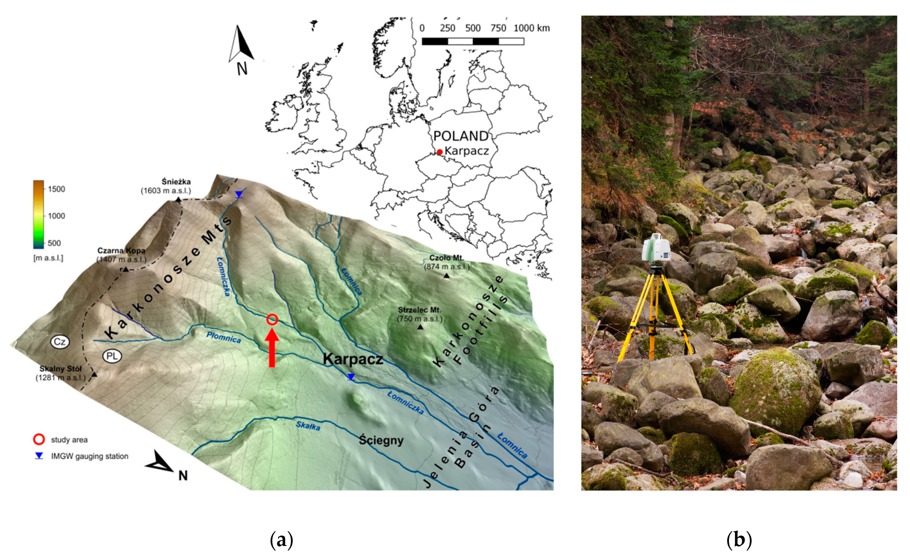
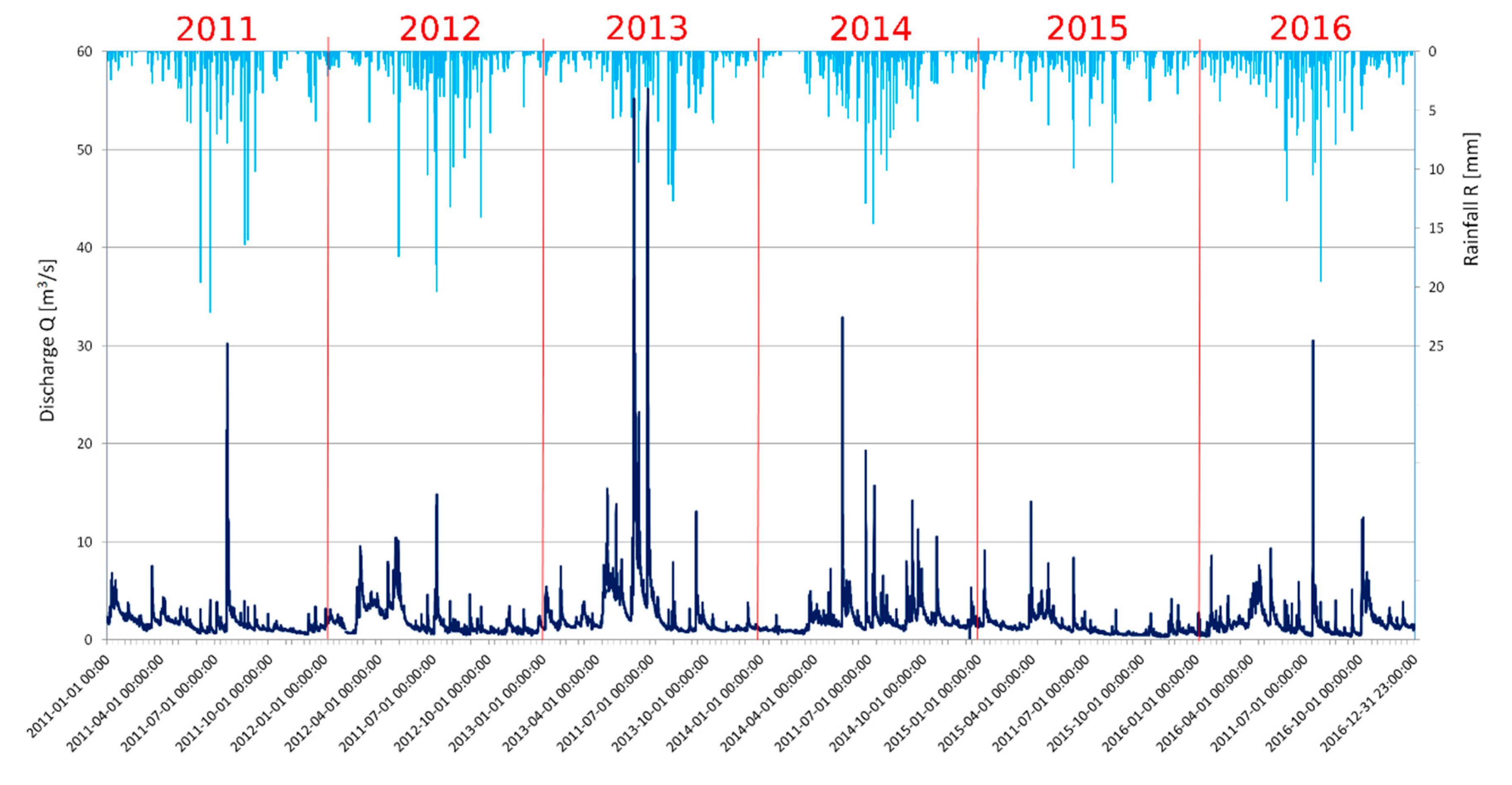
2.1. Study Area
- the spring thaw, often affected by rainfalls in April;
- the precipitation power falling shortly after the thaw in slightly lower parts of the mountains and the snow cover melting in the higher parts during May;
- heavy summer rainfall in July.
2.2. Terrestrial Laser Scanning
- The goal of the monitoring: Since the transportation of boulders happens occasionally during high flow, scanning campaigns are not required to be executed at constant cycles and can be performed with a longer break period, depending on the flow size.
- The season of the investigation: During autumn, the bed of the Łomniczka River stays almost dry. This presents the perfect conditions for scanning since all boulders are almost completely exposed during that time.
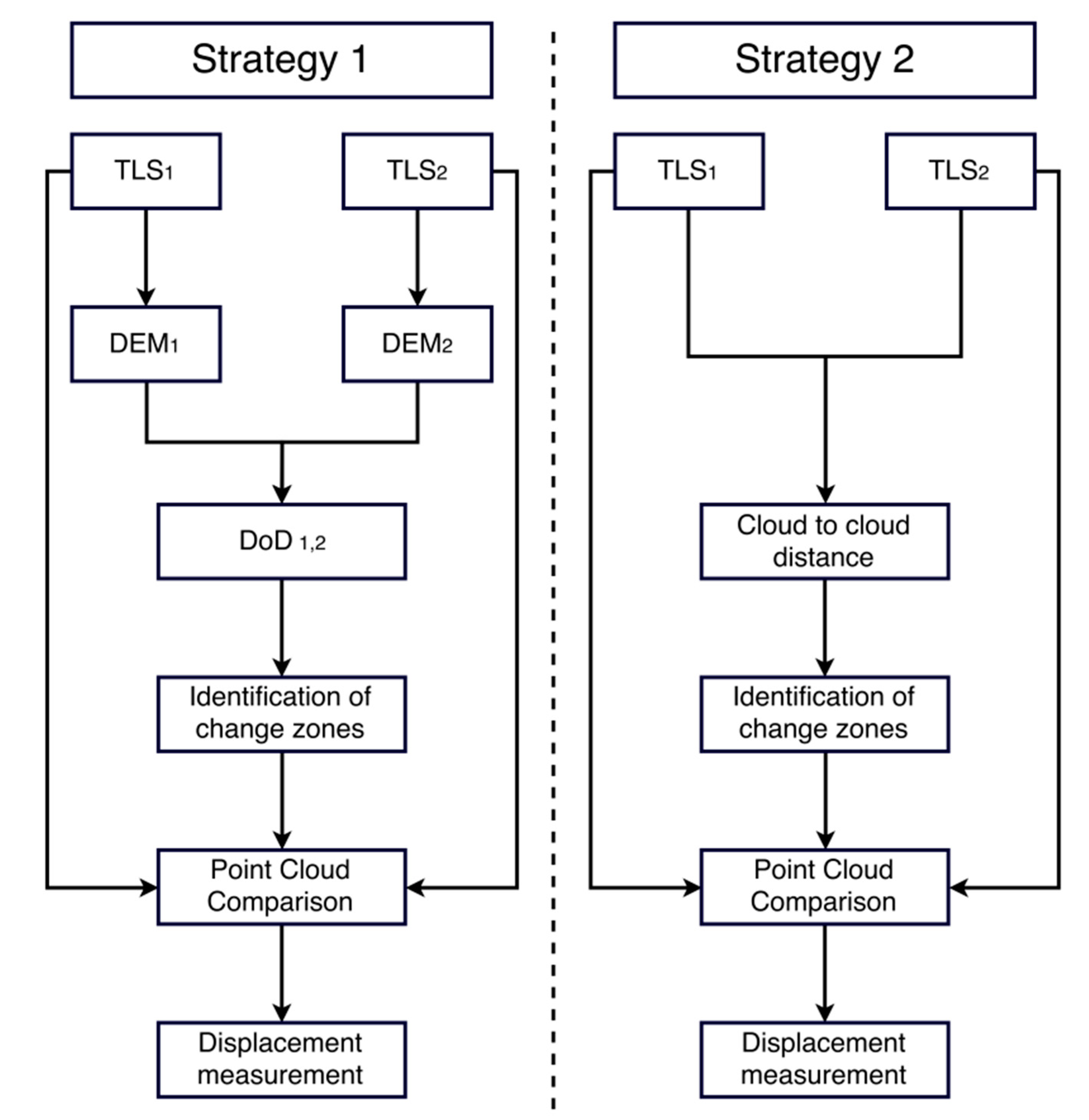
2.3. Detection of Change Zones
2.4. 3D Displacement Determination
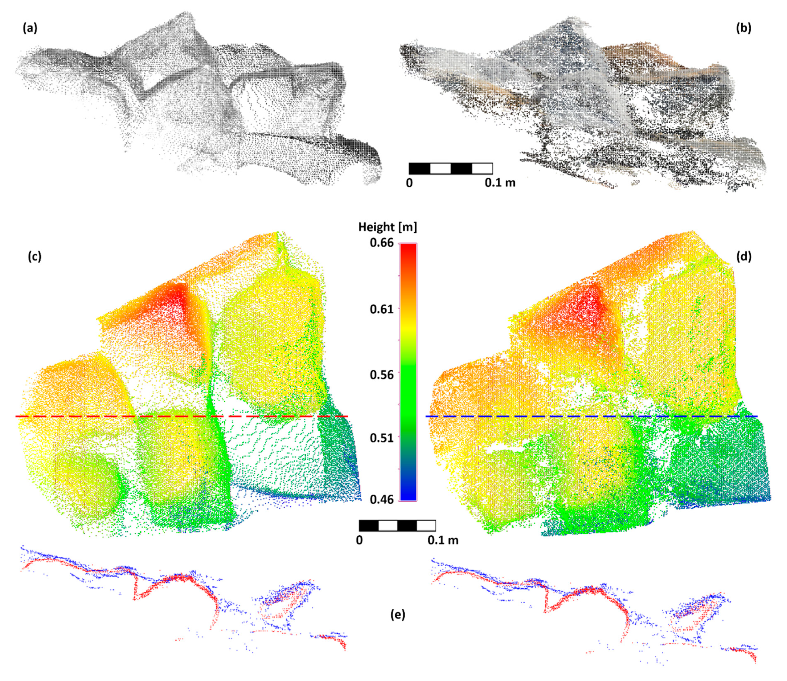
2.5. Synthetic Test
3. Results and Discussion
3.1. Synthetic Test
- 15 particles were moved on different distances and directions (the movement included both translation and rotation);
- three new particles were placed in the test area for the second-epoch measurement;
- one particle was removed from the test area after the first-epoch measurement.
3.2. Real-World Dataset
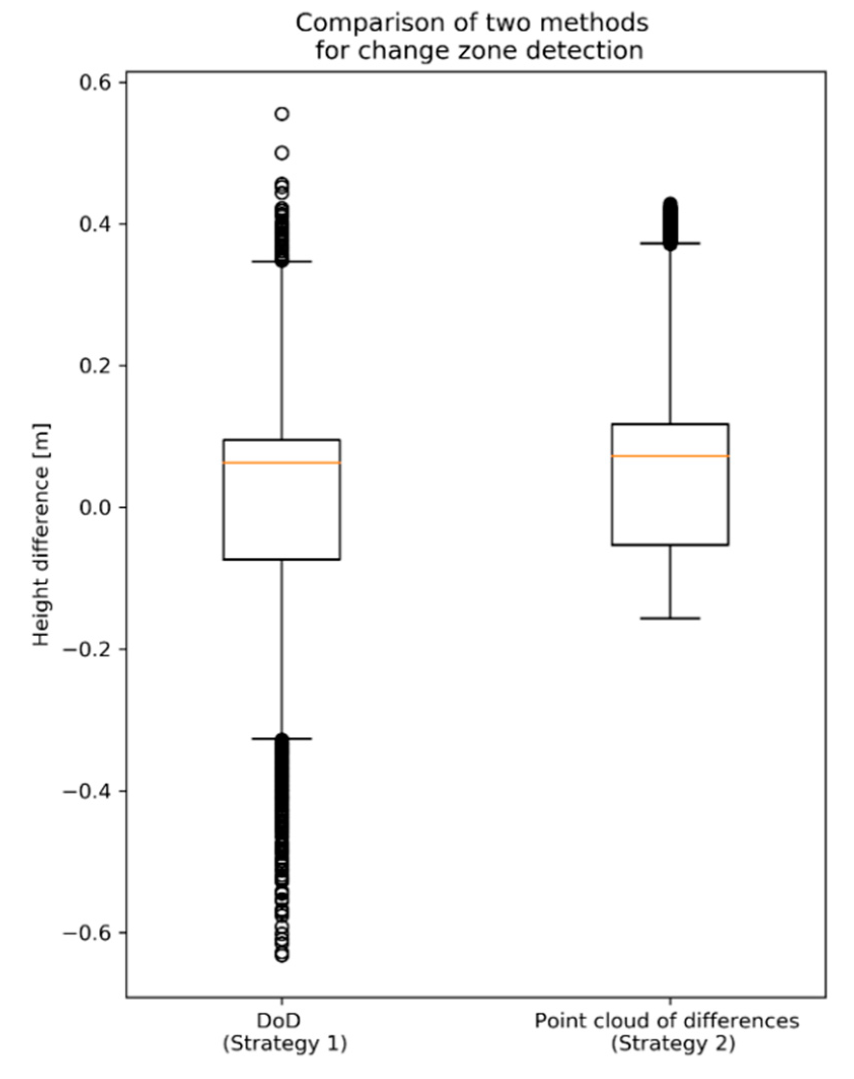
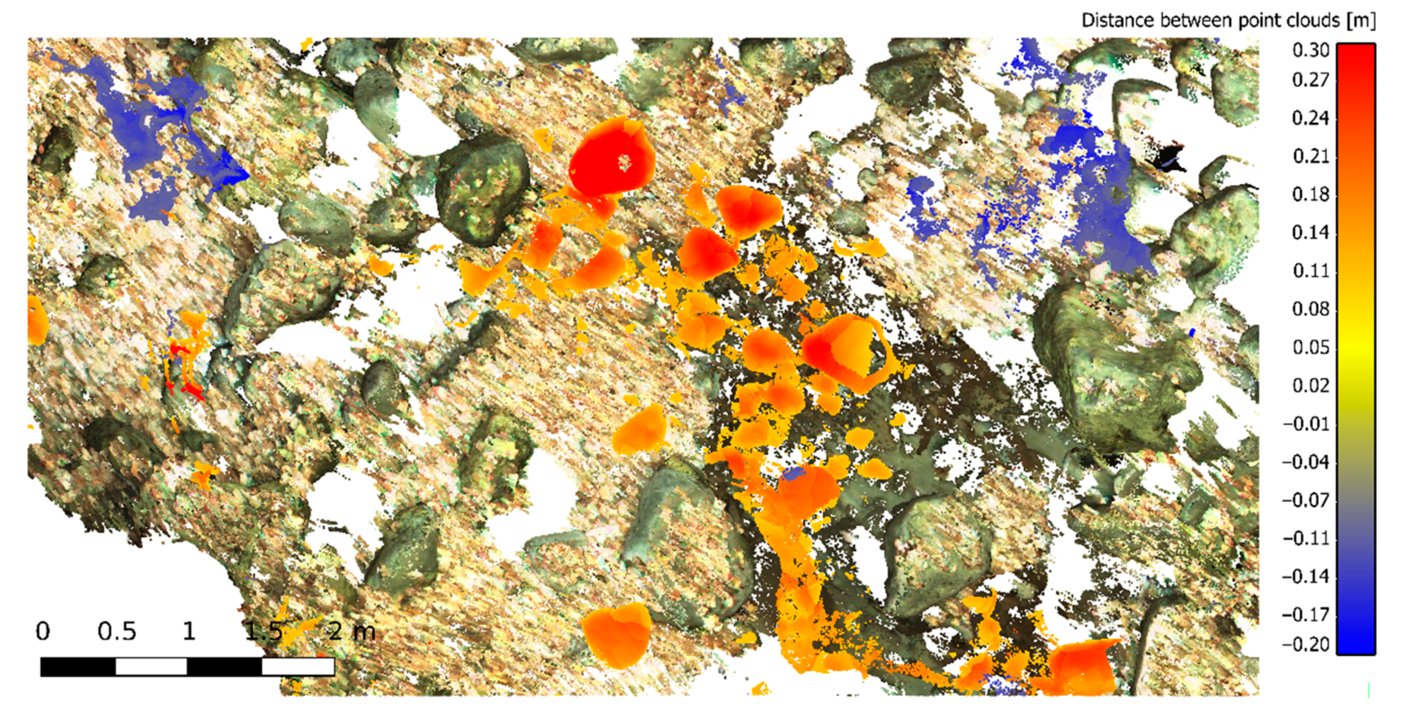
3.2.1. Detection of Change Zones
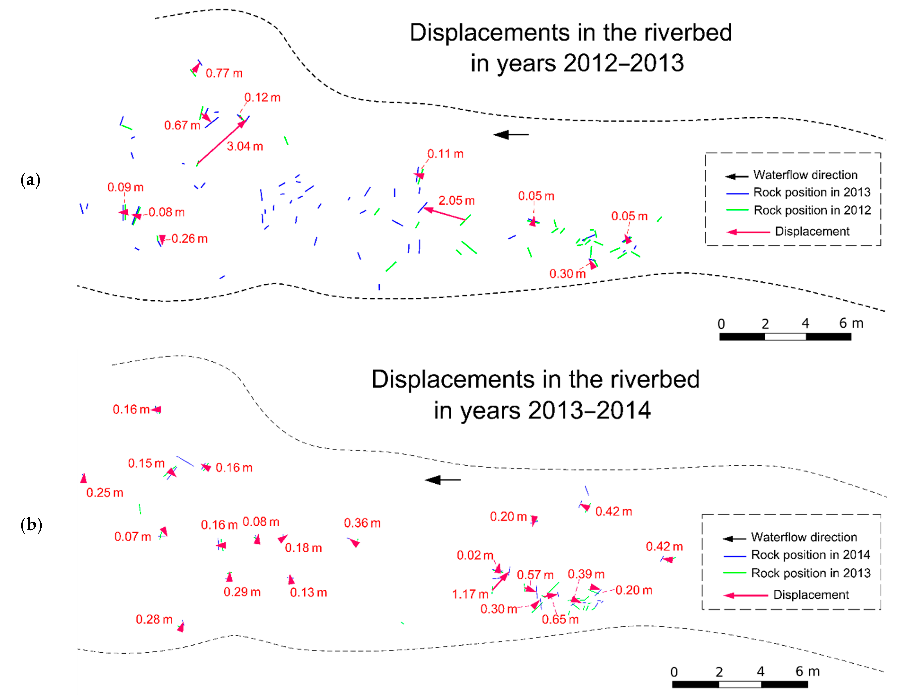
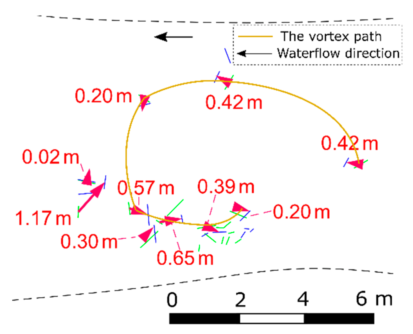
3.2.2. 3D Displacement Determination
3.2.3. Limitations of the Methodology
3.2.4. Alternatives to TLS
4. Conclusions
Author Contributions
Funding
Acknowledgments
Conflicts of Interest
References
- Wilcock, P.R. Toward a practical method for estimating sediment-transport rates in gravel-bed rivers. Earth Surf. Process. Landf. 2001, 26, 1395–1408. [Google Scholar] [CrossRef]
- Recking, A.; Frey, P.; Paquier, A.; Belleudy, P.; Champagne, J.Y. Feedback between bed load transport and flow resistance in gravel and cobble bed rivers. Water Resour. Res. 2008, 44, 1–21. [Google Scholar] [CrossRef]
- Garcia, C.; Laronne, J.B.; Sala, M. Continuous monitoring of bedload flux in a mountain gravel-bed river. Geomorphology 2000, 34, 23–31. [Google Scholar] [CrossRef]
- Bunte, K.; Abt, S.R.; Potyondy, J.P.; Ryan, S.E. Measurement of coarse gravel and cobble transport using portable bedload traps. J. Hydraul. Eng. 2004, 130, 879–893. [Google Scholar] [CrossRef]
- Bergman, N.; Laronne, J.B.; Reid, I. Benefits of design modifications to the Birkbeck bedload sampler illustrated by flash-floods in an ephemeral gravel-bed channel. Earth Surf. Process. Landf. 2007, 32, 317–328. [Google Scholar] [CrossRef]
- Allan, J.C.; Hart, R.; Tranquili, J.V. The use of Passive Integrated Transponder (PIT) tags to trace cobble transport in a mixed sand-and-gravel beach on the high-energy Oregon coast, USA. Mar. Geol. 2006, 232, 63–86. [Google Scholar] [CrossRef]
- Bradley, D.N.; Tucker, G.E. Measuring gravel transport and dispersion in a mountain river using passive radio tracers. Earth Surf. Process. Landf. 2012, 37, 1034–1045. [Google Scholar] [CrossRef]
- Hassan, M.A.; Voepel, H.; Schumer, R.; Parker, G.; Fraccarollo, L. Displacement characteristics of coarse fluvial bed sediment. J. Geophys. Res. Earth Surf. 2013, 118, 155–165. [Google Scholar] [CrossRef]
- Phillips, C.B.; Martin, R.; Jerolmack, D.J. Impulse framework for unsteady flows reveals superdiffusive bed load transport. Geophys. Res. Lett. 2013, 40, 1328–1333. [Google Scholar] [CrossRef]
- Ancey, C.; Heyman, J. A microstructural approach to bed load transport: mean behaviour and fluctuations of particle transport rates. J. Fluid Mech. 2014, 744, 129–168. [Google Scholar] [CrossRef]
- Olinde, L.; Johnson, J.P.L. Using RFID and accelerometer-embedded tracers to measure probabilities of bed load transport, step lengths, and rest times in a mountain stream. Water Resour. Res. 2015, 51, 7572–7589. [Google Scholar] [CrossRef]
- Ancey, C. Stochastic modeling in sediment dynamics: Exner equation for planar bed incipient bed load transport conditions. J. Geophys. Res. Space Phys. 2010, 115. [Google Scholar] [CrossRef]
- Recking, A.; Liébault, F.; Peteuil, C.; Jolimet, T. Testing bedload transport equations with consideration of time scales. Earth Surf. Process. Landf. 2012, 37, 774–789. [Google Scholar] [CrossRef]
- Haddadchi, A.; Omid, M.H.; Dehghani, A.A. Bedload equation analysis using bed load-material grain size. J. Hydrol. Hydromech. 2013, 61, 241–249. [Google Scholar] [CrossRef][Green Version]
- Vázquez-Tarrío, D.; Menéndez-Duarte, R. Assessment of bedload equations using data obtained with tracers in two coarse-bed mountain streams (Narcea River basin, NW Spain). Geomorphol. 2015, 238, 78–93. [Google Scholar] [CrossRef]
- Vosselman, G.; Maas, H.G. Airborne and Terrestrial Laser Scanning; Whittles Publishing: Scotland, UK, 2010; pp. 1–336. [Google Scholar]
- Heritage, G.L.; Milan, D.J. Terrestrial Laser Scanning of grain roughness in a gravel-bed river. Geomorphology 2009, 113, 4–11. [Google Scholar] [CrossRef]
- Theule, J.I.; Liebault, F.; Loye, A.; Laigle, D.; Jaboyedoff, M. Sediment budget monitoring of debris-flow and bedload transport in the Manival Torrent, SE France. Nat. Hazards Earth Syst. Sci. 2012, 12, 731–749. [Google Scholar] [CrossRef]
- Picco, L.; Mao, L.; Cavalli, M.; Buzzi, E.; Rainato, R.; Lenzi, M. Evaluating short-term morphological changes in a gravel-bed braided river using terrestrial laser scanner. Geomorphology 2013, 201, 323–334. [Google Scholar] [CrossRef]
- Kuo, C.-W.; Brierley, G.; Chang, Y.H. Monitoring channel responses to flood events of low to moderate magnitudes in a bedrock-dominated river using morphological budgeting by terrestrial laser scanning. Geomorphology 2015, 235, 1–14. [Google Scholar] [CrossRef]
- Brasington, J.; Vericat, D.; Rychkov, I. Modeling river bed morphology, roughness, and surface sedimentology using high resolution terrestrial laser scanning. Water Resour. Res. 2012, 48, W11519. [Google Scholar] [CrossRef]
- Baewert, H.; Bimböse, M.; Bryk, A.; Rascher, E.; Schmidt, K.-H.; Morche, D. Roughness determination of coarse grained alpine river bed surfaces using Terrestrial Laser Scanning data. Z. Geomorphol. Suppl. Issues 2014, 58, 81–95. [Google Scholar] [CrossRef]
- Hodge, R.; Brasington, J.; Richards, K. Analysing laser-scanned digital terrain models of gravel bed surfaces: linking morphology to sediment transport processes and hydraulics. Sedimentology 2009, 56, 2024–2043. [Google Scholar] [CrossRef]
- Williams, R.; Rennie, C.; Brasington, J.; Hicks, M.; Vericat, D. Linking the spatial distribution of bed load transport to morphological change during high-flow events in a shallow braided river. J. Geophys. Res. 2013, 120, 604–622. [Google Scholar] [CrossRef]
- Jozkow, G.; Borkowski, A.; Kasprzak, M. Monitoring of fluvial transport in the mountain river bed using terrestrial laser scanning. ISPRS Int. Arch. Photogramm. Remote Sens. Spat. Inf. Sci. 2016, 41, 523–528. [Google Scholar] [CrossRef]
- Lotsari, E.; Wang, Y.; Kaartinen, H.; Jaakkola, A.; Kukko, A.; Vaaja, M.; Hyyppä, H.; Hyyppä, J.; Alho, P. Gravel transport by ice in a subarctic river from accurate laser scanning. Geomorphology 2015, 246, 113–122. [Google Scholar] [CrossRef]
- Dubicki, A.; Mordalska, H.; Tokarczyk, T.; Adynkiewicz-Piragas, M. Wody Powierzchniowe Karkonoszy (Surface Water of Karkonosze Mountains). In Karkonosze: Przyroda nieożywiona i człowiek (Karkonosze: Inanimate Nature and Man); Mierzejewski, M.P., Ed.; Wyd. Uniwersytetu Wrocławskiego: Wrocław, Poland, 2005; pp. 399–425. (In Polish) [Google Scholar]
- Bieroński, J.; Pawlak, W.; Tomaszewski, J. Komentarz do Mapy Hydrograficznej w Skali 1:50 000 (Comment on the Hydrographical Map in Scale 1:50000); Arkusz (sheet) M-33-44-C Szklarska Poręba; GEPOL: Poznań, Poland, 2002. (In Polish) [Google Scholar]
- Kasprzak, M.; Migoń, P. Historical and recent floods in the West Sudetes—geomorphological dimension. Z. Geomorphol. Suppl. Issues 2015, 59, 73–97. [Google Scholar] [CrossRef]
- Smith, M.; Vericat, D.; Gibbins, C. Through-water terrestrial laser scanning of gravel beds at the patch scale. Earth Surf. Process. Landforms. 2012, 37, 411–421. [Google Scholar] [CrossRef]
- Heritage, G.; Hetherington, D. Towards a protocol for laser scanning in fluvial Geomorphology. Earth Surf. Process. Landf. 2007, 32, 66–74. [Google Scholar] [CrossRef]
- Wang, Y.; Liang, X.; Flener, C.; Kukko, A.; Kaartinen, H.; Kurkela, M.; Vaaja, M.; Hyyppä, H.; Alho, P. 3D Modeling of Coarse Fluvial Sediments Based on Mobile Laser Scanning Data. Remote Sens. 2013, 5, 4571–4592. [Google Scholar] [CrossRef]
- Bangen, S.G.; Wheaton, J.M.; Bouwes, N.; Bouwes, B.; Jordan, C. A methodological intercomparison of topographic survey techniques for characterizing wadeable streams and rivers. Geomorphology 2014, 206, 343–361. [Google Scholar] [CrossRef]
- Girardeau-Montaut, D. CloudCompare—Open Source Project. 2016. Available online: http://www.danielgm.net/cc/ (accessed on 26 April 2017).
- Lana-Renault, N.; Alvera, B.; García-Ruiz, J.M. Runoff and sediment transport during the snowmelt period in a Mediterranean high-mountain catchment. Arct. Antarct. Alp. Res. 2011, 43, 213–222. [Google Scholar] [CrossRef]
- Beylich, A.A.; Gintz, D. Effects of high-magnitude/low-frequency fluvial events generated by intense snowmelt or heavy rainfall in arctic periglacial environments in northern Swedish Lapland and Northern Siberia. Geogr. Ann. Ser. A Phys. Geogr. 2004, 86, 11–29. [Google Scholar] [CrossRef]
- Kociuba, W.; Janicki, G.; Siwek, K.; Gluza, A. Bedload transport as an indicator of contemporary transformations of arctic fluvial systems. DEBRIS Flows 2012, 1, 125–135. [Google Scholar]
- Noss, C.; Lorke, A. Roughness, resistance, and dispersion: Relationships in small streams. Water Resour. Res. 2016, 52, 2802–2821. [Google Scholar] [CrossRef]
- Tuijnder, A.P.; Ribberink, J.S. Experimental observation and modelling of roughness variation due to supply-limited sediment transport in uni-directional flow. J. Hydraul. Res. 2012, 50, 506–520. [Google Scholar] [CrossRef]
- Remondino, F.; Spera, M.G.; Nocerino, E.; Menna, F.; Nex, F. State of the art in high density image matching. Photogramm. Rec. 2014, 29, 144–166. [Google Scholar] [CrossRef]
- Wolff, K.; Kim, C.; Zimmer, H.; Schroers, C.; Botsch, M.; Sorkine-Hornung, O.; Sorkine-Hornung, A. Point Cloud Noise and Outlier Removal for Image-Based 3D Reconstruction. In Proceedings of the 2016 4th International Conference on 3D Vision (3DV), Stanford, CA, USA, 25–28 October 2016; pp. 118–127. [Google Scholar]


| Watercourse Characteristics | Upper Gauge Station | Lower Gauge Station (Karpacz) |
|---|---|---|
| Length of the stream | 0.55 km | 6.5 km |
| Catchment area | 0.46 km2 | 12.1 km2 |
| Average inclination of the stream | 89‰ | 136‰ |
| Average annual low water level | – | 111 cm |
| Average annual medium water level | – | 121 cm |
| Average annual high water level | – | 169 cm |
| Average annual low flow | 0.007 m3 s−1 | 0.09 m3 s−1 |
| Average annual medium flow | 0.024 m3 s−1 | 0.42 m3 s−1 |
| Average annual high flow | 0.71 m3 s−1 | 9.09 m3 s−1 |
| Maximum recorded water level | – | 260 cm (7 July 1997) |
| Maximum recorded water flow | – | 51.6 m3 s−1 (7 July 1997) |
| Parameter | Leica ScanStation C10 | Leica ScanStation P20 |
|---|---|---|
| Laser wavelength | 532 nm (green) | 808 nm/658 nm (infrared/red) |
| Horizontal field of view | 360° | 360° |
| Vertical field of view | 270° | 270° |
| Range | 300 m @90% albedo | 120 m |
| 134 m @18% albedo | ||
| Maximum scan rate | 50,000 points/s | 1,000,000 points/s |
| Point 3D position accuracy | 6 mm | 3 mm |
| Range accuracy | 4 mm | <1 mm |
| Target acquisition standard deviation | 2 mm | 2 mm |
| Measurement Epoch | 2011 | 2012 | 2013 | 2014 | 2015 | 2016 |
|---|---|---|---|---|---|---|
| Date of measurement | 10 November | 23 October | 24 October | 4 October | 30 October | 17 November |
| Registration mean absolute error (mm) | 1 | 1 | 2 | 2 | 2 | 2 |
| Georeferencing mean absolute error (mm) | 3 | 11 | 6 | 4 | 5 | 8 |
| Movement Type | Correctly Identified | Incorrectly Identified | Not Identified |
|---|---|---|---|
| Moved particles | 14 | 1 | 0 |
| New particles in the area | 3 | 0 | 0 |
| Particles removed from the area | 0 | 0 | 1 |
| Number | Distance (D) (m) | Reference Distance (DRef) (m) | ∆D = D − DRef (m) |
|---|---|---|---|
| 1 | 0.12 | 0.12 | 0 |
| 2 | 0.11 | 0.11 | 0 |
| 3 | 0.89 | 0.90 | 0.01 |
| 4 | 0.30 | 0.30 | 0 |
| 5 | 0.41 | 0.40 | 0.01 |
| 6 | 1.27 | 1.26 | 0.01 |
| 7 | 0.15 | 0.06 | 0.09 |
| 8 | 0.85 | 0.82 | 0.03 |
| 9 | 0.03 | 0.05 | −0.02 |
| 10 | 1.58 | 1.60 | −0.02 |
| 11 | 1.13 | 1.16 | −0.03 |
| 12 | 0.58 | 0.58 | 0 |
| 13 | 1.02 | 1.13 | −0.11 |
| 14 | 0.22 | 0.21 | 0.01 |
| RMSE | 0.04 | ||
© 2019 by the authors. Licensee MDPI, Basel, Switzerland. This article is an open access article distributed under the terms and conditions of the Creative Commons Attribution (CC BY) license (http://creativecommons.org/licenses/by/4.0/).
Share and Cite
Walicka, A.; Jóźków, G.; Kasprzak, M.; Borkowski, A. Terrestrial Laser Scanning for the Detection of Coarse Grain Size Movement in a Mountain Riverbed. Water 2019, 11, 2199. https://doi.org/10.3390/w11112199
Walicka A, Jóźków G, Kasprzak M, Borkowski A. Terrestrial Laser Scanning for the Detection of Coarse Grain Size Movement in a Mountain Riverbed. Water. 2019; 11(11):2199. https://doi.org/10.3390/w11112199
Chicago/Turabian StyleWalicka, Agata, Grzegorz Jóźków, Marek Kasprzak, and Andrzej Borkowski. 2019. "Terrestrial Laser Scanning for the Detection of Coarse Grain Size Movement in a Mountain Riverbed" Water 11, no. 11: 2199. https://doi.org/10.3390/w11112199
APA StyleWalicka, A., Jóźków, G., Kasprzak, M., & Borkowski, A. (2019). Terrestrial Laser Scanning for the Detection of Coarse Grain Size Movement in a Mountain Riverbed. Water, 11(11), 2199. https://doi.org/10.3390/w11112199