Potential Benefits of Managed Aquifer Recharge MAR on the Island of Gotland, Sweden


 ,
, 
Abstract
1. Introduction
2. Materials and Methods
2.1. Materials
2.2. Methods
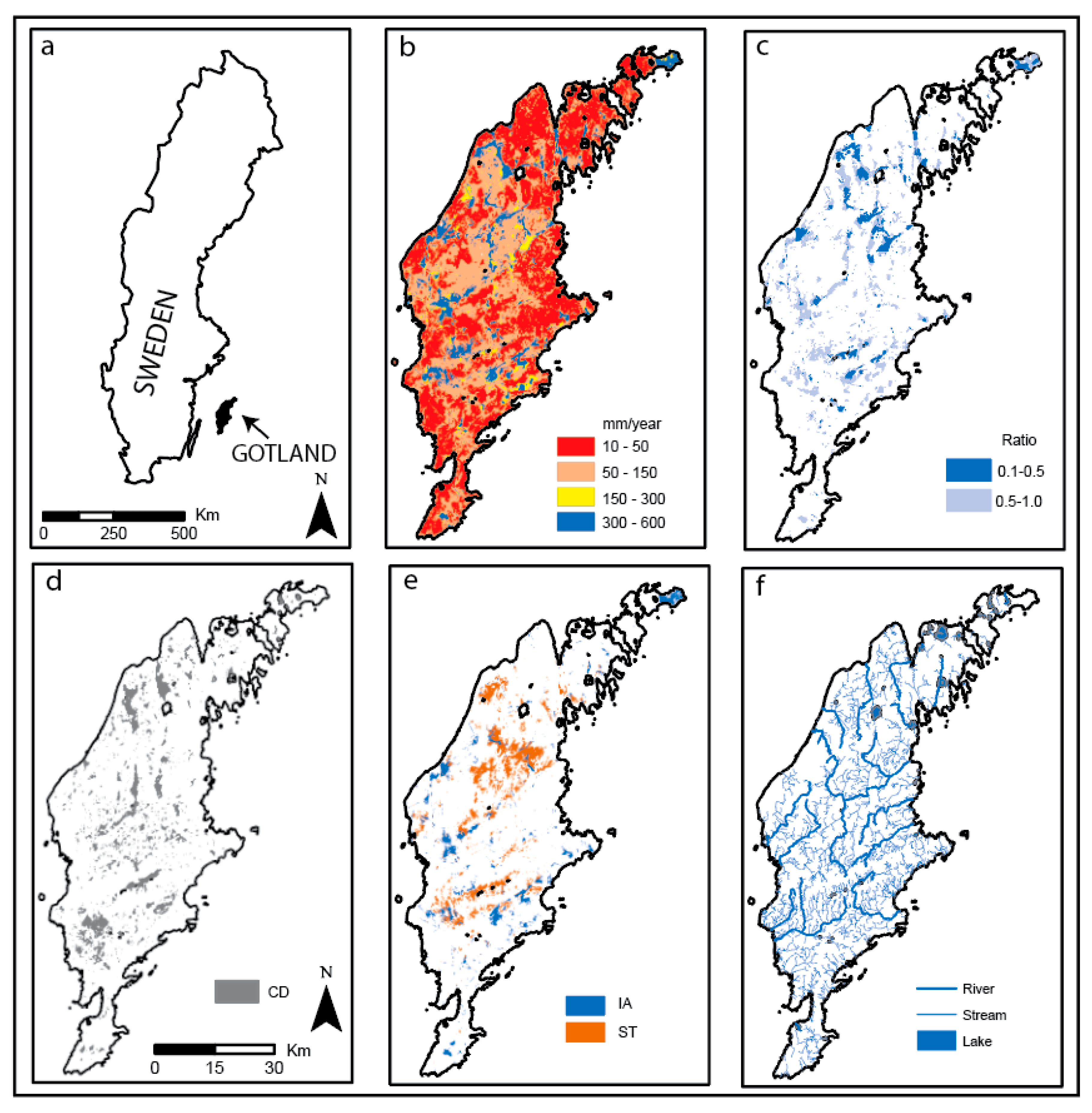
- The aquifer storage capacity of the soil and bedrock were previously estimated by the Geological Survey of Sweden (SGU) on a national scale (Figure 1b) and should be used with caution on scales below 1:100,000 on Gotland. The groundwater storage capacity is based on assessments of porosity of soil and bedrock types, soil thickness, groundwater surface and possible drawdown caused by groundwater withdrawal [25]. A modeled annual groundwater recharge map for Sweden (national scale, coarse resolution) was made in 2006 [26]. Values of natural groundwater recharge on Gotland used in this analysis were either 200 or 260 mm/year, depending on location. A raster containing the ratio between groundwater recharge and groundwater storage capacity was created, and values below 1.0 indicate areas with potential to store more groundwater than the natural recharge, i.e., they might be suitable for MAR. This raster is abbreviated as GS and is shown in Figure 1c.
- The geological 3D model for Gotland includes a bedrock surface. A GIS analysis identified depressions in the bedrock surface, assuming that these areas are generally favorable for storage of groundwater. Some of these areas coincide with lakes, whereas others are “hidden” depressions with little or no surface expression because they have been infilled by soils. A selection was made to show only closed depressions larger than 1 hectare and with no contact with the Baltic Sea. Water has a higher potential in these areas for storage without being lost as a shallow groundwater outflow through the permeable soil (Figure 1d). The resulting raster is named Closed Depressions (CD).
- Through selection from the lithological 3D model of Gotland, areas with >4 m thickness of sand and/or gravel (Figure 1e) were identified. This geological environment is important on both local and regional scales because these high permeability deposits increase infiltration to the bedrock aquifer. The resulting raster is abbreviated as IA.
- To assess the possibility of storing surface water in dams, areas with over 4 m thickness of till and or clay were selected from the lithological 3D model of Gotland (Figure 1e). In these areas the construction of sufficiently large storage dams will be a relatively easy and cheap operation since the construction material can be sourced on site. The resulting raster is abbreviated as ST (Surface water storage).
- Because of arable land drainage, thin soil cover and relatively impermeable bedrock, most streams and rivers on Gotland have high flow rates during the winter (November–March; [1]). Even small streams can serve as good sources of water supply if the water can be stored (e.g., in man-made dams or wetlands) until the spring and summer. Lakes are rare on the island and mostly very shallow. Lakes and streams may both be regulated to increase the available source but that is not discussed in this paper. A GIS-based analysis of proximity to surface waters was made with a buffer of 0.2 km on smaller streams (sometimes intermittent) and 0.5 km for perennial rivers and lakes (Figure 1f, raster abbreviation S). This difference in distance reflects a variation in the estimation of cost effectiveness and can be further explored.
3. Results
3.1. Mapping of Suitable MAR and Source Areas
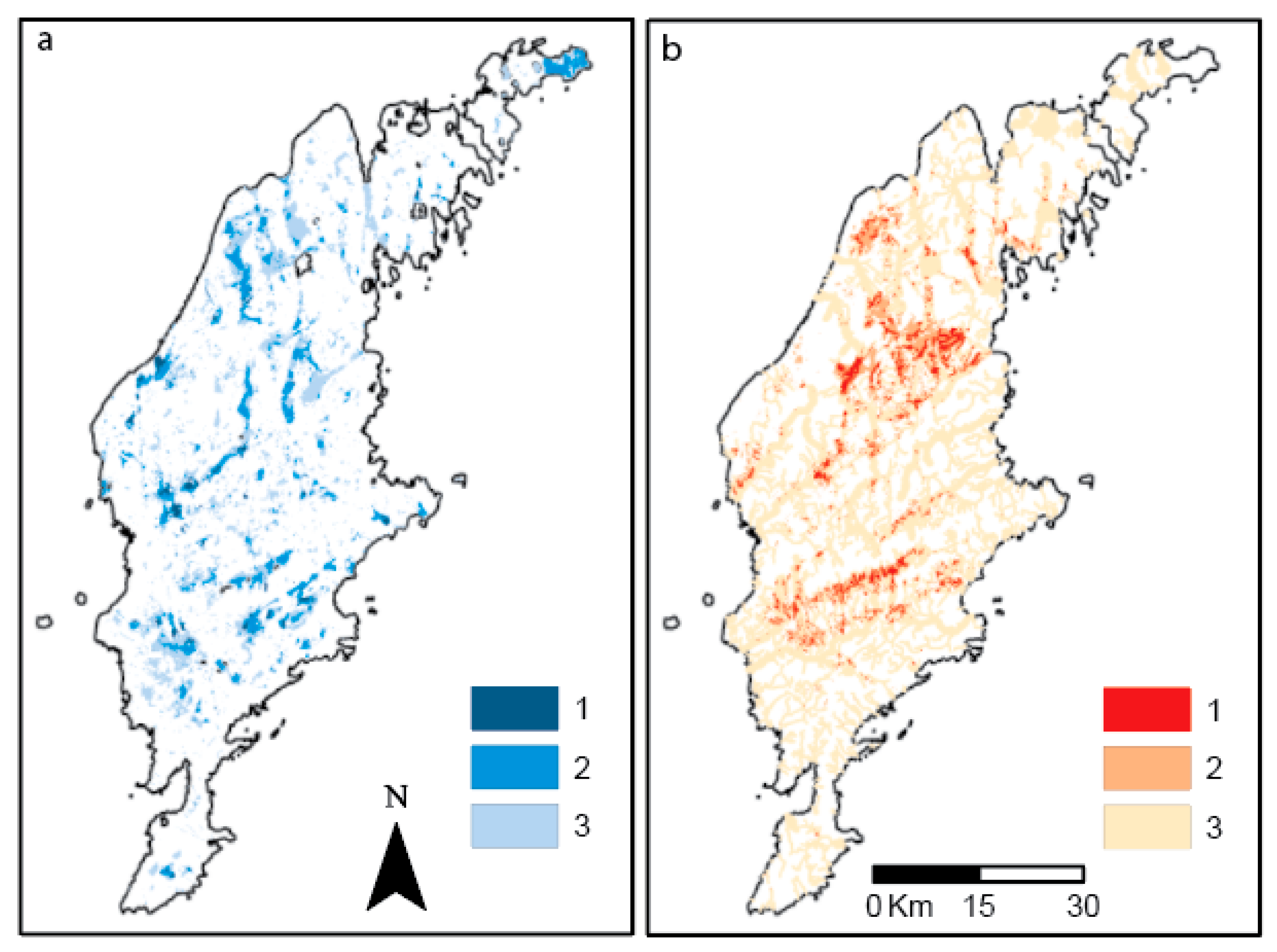
3.1.1. Infiltration Areas and Areas for Groundwater Storage (IA + GS + CD)
3.1.2. Source and Suitable Areas for Surface Water Storage (S + ST)
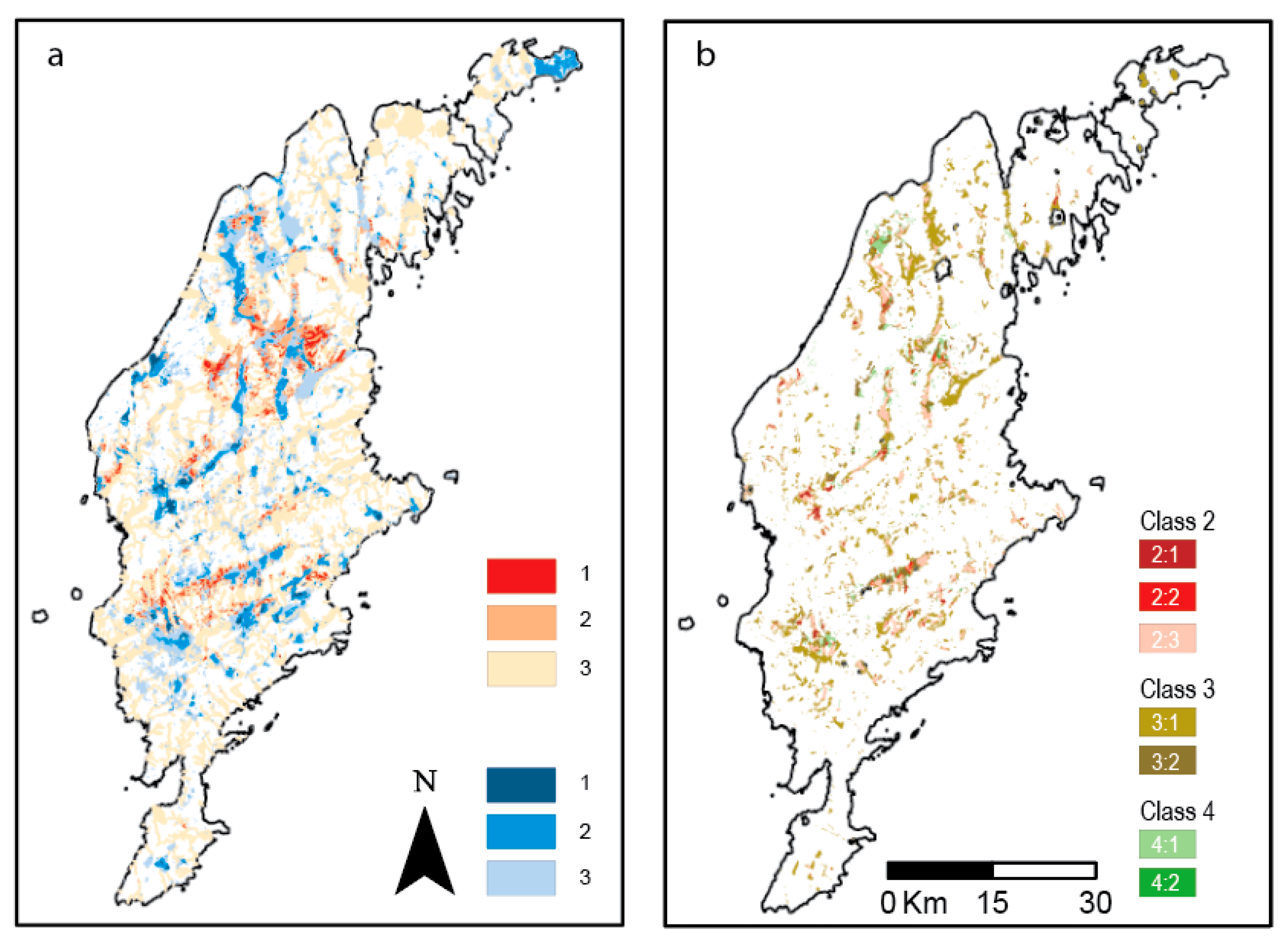
3.1.3. Areas with Combination of Infiltration, Groundwater Storage, Source and Surface Water Storage (IA + GS + CD + S + ST)
3.2. Estimation of Increased Groundwater Recharge and Groundwater Extraction at MAR Favorable Groundwater Catchments in Use Today
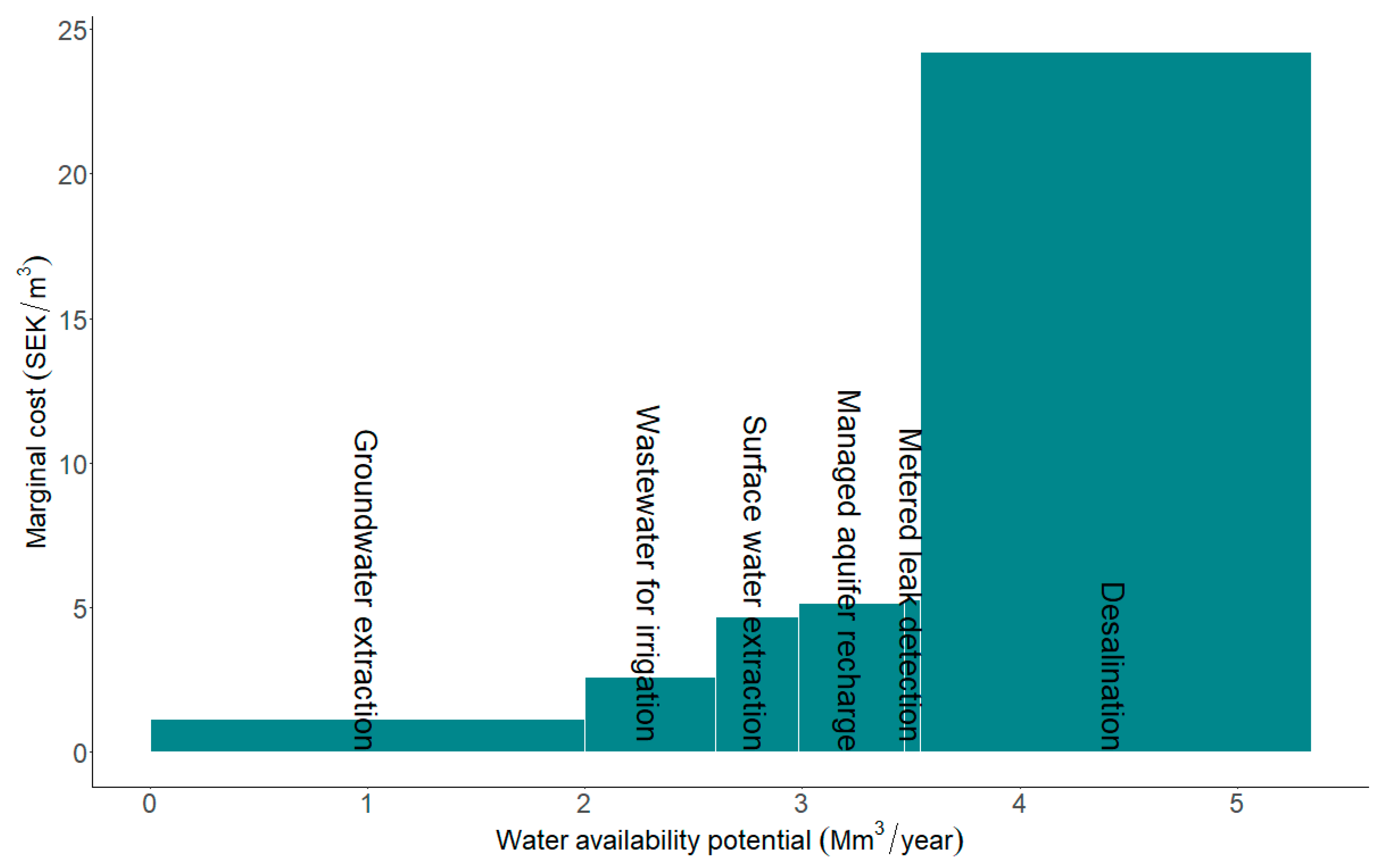
3.3. Comparative Study of Alternative Measures
4. Discussion
5. Conclusions
- The best conditions for infiltration and groundwater storage occur in a total area of ca 2000 ha (0.7% of Gotland), second best in 14,400 ha (4.8% of Gotland), and third best in 43,000 ha (14% of Gotland).
- Areas with both proximity to a raw water source and conditions for storage in dams occur in a total area of ca 10,000 ha (3.3% of Gotland).
- An area of ca 7700 ha (2.5% of Gotland) has good local conditions for MAR and an area of ca 22,700 ha (7.5% of Gotland) has moderate local conditions for MAR.
- Decision support is provided by comparing MAR with other measures in a marginal abatement cost curve, contributing to informed prioritizations and decisions on water resource improvement on Gotland.
- MAR is not the alternative with the largest water availability potential, but it has significantly lower marginal costs compared, for example, with desalination, and the potential will increase if also considering new well fields and in preventing adverse consequences of increased abstraction.
- The water supply potential of MAR in existing well fields (public water supply) was estimated to be about 35% of the forecasted drinking water supply and 7% of the total water demand gap in year 2045. The total water supply potential of MAR on Gotland is much larger and is expected to exceed the demand.
Author Contributions
Funding
Acknowledgments
Conflicts of Interest
References
- Länsstyrelsen. Regional Water Supply Plan of Gotland; County Administrative Board of Gotland: Gotland, Sweden, 2018. (In Swedish) [Google Scholar]
- Dahlqvist, P.; Thorsbrink, M.; Holgersson, B.; Nisell, J.; Maxe, L.; Gustafsson, M. Wet Lands and Groundwater Recharge—Possibilities for Increased Capacity at Groundwater Catchments in Gotland; SGU-Rapport 2017:01; Sveriges Geologiska Undersökning: Uppsala, Sweden, 2017; 73p. (In Swedish) [Google Scholar]
- Erlström, M.; Persson, L.; Sivhed, U.; Wickström, L. Description of the Bedrock on Gotland; Sveriges Geologiska Undersökning K221; Sveriges Geologiska Undersökning: Uppsala, Sweden, 2009; 60p. (In Swedish) [Google Scholar]
- Hansson, G. Artificial groundwater recharge—A method used in Swedish drinking water supply for 100 years. VA Forsk 2000, 5, 96–106, (In Swedish with English Summary). [Google Scholar]
- Dillon, P. Future management of aquifer recharge. Hydrogeol. J. 2005, 13, 313–316. [Google Scholar] [CrossRef]
- Stefan, C.; Ansems, N. Web-based global inventory of managed aquifer recharge applications. Sustain. Water Resour. Manag. 2017, 4, 153–162. [Google Scholar] [CrossRef]
- Sprenger, C.; Hartog, N.; Hernández, M.; Vilanova, E.; Grützmacher, G.; Scheibler, F.; Hannappel, S. Inventory of managed aquifer recharge sites in Europe: Historical development, current situation and perspectives. Hydrogeol. J. 2017, 6, 1909–1922. [Google Scholar] [CrossRef]
- National Water Quality Management Strategy. Australian Guidelines for Water Recycling; Water Quality Australia: Canberra, Australia, 2009; Volume 24, 251p.
- IGRAC (International Groundwater Resource Assessment Centre). Global Inventory of Managed Aquifer Recharge (MAR) Schemes. 2015. Available online: https://ggis.un-igrac.org/ggis-viewer/viewer/globalmar/public/default (accessed on 22 June 2018).
- Rahman, M.A.; Rusteberg, B.; Gogu, R.C.; Lobo Ferreira, J.P.; Sauter, M. A new spatial multi-criteria decision support tool for site selection for implementation of managed aquifer recharge. J. Environ. Manag. 2012, 99, 61–75. [Google Scholar] [CrossRef]
- Russo, T.A.; Fisher, A.T.; Lockwood, B.S. Assessment of managed aquifer recharge site suitability using a GIS and modeling. Groundwater 2015, 53, 389–400. [Google Scholar] [CrossRef]
- Malczewski, J. GIS and Multicriteria Decision Analysis; John Wiley & Sons: Hoboken, NJ, USA, 1999. [Google Scholar]
- Sallwey, J.; Bonilla Valverde, J.P.; Vásquez López, F.; Junghanns, R.; Stefan, C. Suitability maps for managed aquifer recharge: A review of multi-criteria decision analysis studies. Environ. Rev. 2018, 27, 138–150. [Google Scholar] [CrossRef]
- Maples, S.R.; Foglia, L.; Fogg, G.E.; Maxwell, R.M. Sensitivity of hydrologic and geologic parameters on recharge processes in a highly-heterogeneous, semi-confined aquifer system. Hydrol. Earth Syst. Sci. Discuss. 2019. [Google Scholar] [CrossRef]
- Asano, T.; Cotruvo, J.A. Groundwater recharge with reclaimed municipal wastewater: Health and regulatory considerations. Water Res. 2004, 38, 1941–1951. [Google Scholar] [CrossRef] [PubMed]
- Bekele, E.; Pattersson, B.; Toze, S.; Furness, A.; Higginson, S.; Shackelton, M. Aquifer residence times for recycled water estimated using chemical tracers and the propagation of temperature signals at a managed aquifer recharge site in Australia. Hydrogeol. J. 2014, 22, 1383–1401. [Google Scholar] [CrossRef]
- Greskowiak, J.; Prommer, H.; Massmann, G.; Johnston, C.D.; Nützmann, G.; Pekdeger, A. The impact of variably saturated conditions on hydrogeochemical changes during artificial recharge of groundwater. Appl. Geochem. 2005, 20, 1409–1426. [Google Scholar] [CrossRef]
- Moeck, C.; Radny, D.; Auckenthaler, A.; Berg, M.; Hollender, J.; Schirmer, M. Estimating the spatial distribution of artificial groundwater recharge using multiple tracers. Isot. Environ. Health Stud. 2017, 53, 484–499. [Google Scholar] [CrossRef] [PubMed]
- Franssen, H.J.H.; Kaiser, H.P.; Kuhlmann, U.; Bauser, G.; Stauffer, F.; Muller, R.; Kinzelbach, W. Operational real-time modelling with ensemble Kalman filter of variably saturated subsurface flow including stream-aquifer interaction and parameter updating. Water Resour. Res. 2011, 47. [Google Scholar] [CrossRef]
- Fernández Escalante, E.; Calero Gil, R.; San Miguel Fraile, M.Á.; Sánchez Serrano, F. Economic assessment of opportunities for managed aquifer recharge techniques in Spain using an advanced geographic information system (GIS). Water 2014, 6, 2021–2040. [Google Scholar] [CrossRef]
- Megdal, S.B.; Dillon, P. Policy and economics of managed aquifer recharge and water banking. Water 2015, 7, 592–598. [Google Scholar] [CrossRef]
- Ross, A.; Hasnain, S. Factors affecting the cost of managed aquifer recharge (MAR) schemes. Sustain. Water Resour. Manag. 2018, 4, 179–190. [Google Scholar] [CrossRef]
- Dahlqvist, P.; Triumf, C.-A.; Persson, L.; Bastani, M.; Erlström, M.; Jørgensen, F.; Thulin Olander, H.; Gustafsson, M.; Thorsbrink, M.; Schoning, K.; et al. SkyTEM-Survey on Gotland; Rapporter och Meddelanden 136; Sveriges Geologiska Undersökning: Uppsala, Sweden, 2015; 108p. (In Swedish) [Google Scholar]
- Dahlqvist, P.; Triumf, C.-A.; Persson, L.; Bastani, M.; Erlström, M.; Schoning, K. SkyTEM-Survey on Gotland, Part 2; Rapporter och Meddelanden 140; Sveriges Geologiska Undersökning: Uppsala, Sweden, 2017; 135p. (In Swedish) [Google Scholar]
- Geological Survey of Sweden. Report of Government Mandate: Groundwater Recharge and Resources in Sweden; SGU-Rapport 2017:09; Geological Survey of Sweden: Uppsala, Sweden, 2017; 45p. (In Swedish) [Google Scholar]
- Rodhe, A.; Lindström, G.; Rosberg, J.; Pers, C. Groundwater Recharge in Swedish Soils—A General Calculation with a Water Balance Model; Institutionen för Geovetenskaper, Luft-och Vattenlära, Uppsala Universitet, Rapport, Serie A; Uppsala Universitet: Uppsala, Sweden, 2006; Volume 66, 35p. (In Swedish) [Google Scholar]
- Addams, L.; Boccaletti, G.; Kerlin, M.; Stuchtey, M. Charting Our Water Future—Economic Frameworks to Inform Decision-Making; 2030 Water Resources Group: Washington, DC, USA, 2009. [Google Scholar]
- Eory, V.; Pellerin, S.; Carmona Garcia, G.; Lehtonen, H.; Licite, I.; Mattila, H.; Lund-Sørensen, T.; Muldowney, J.; Popluga, D.; Strandmark, L.; et al. Marginal abatement cost curves for agricultural climate policy: State-of-the art, lessons learnt and future potential. J. Clean. Prod. 2018, 182, 705–716. [Google Scholar] [CrossRef]
- Hastings, N.A.J. Physical Asset Management: With an Introduction to ISO55000; Springer International Publishing: Cham, Switzerland, 2015. [Google Scholar]
- Brealey, R.A.; Myers, S.C.; Allen, F. Principles of Corporate Finance, 10th ed.; McGraw-Hill/Irwin: New York, NY, USA, 2010. [Google Scholar]
- Onder, H.; Yilmaz, M. Underground dams. A tool of sustainable development and management of groundwater resources. Eur. Water 2005, 11, 35–45. [Google Scholar]
- Sallwey, J.; Schlick, R.; Bonilla Valverde, J.P.; Junghanns, R.; Vásquez López, F.; Stefan, C. Suitability maps for managed aquifer recharge: Review and tool development. Abstract 33. In Proceedings of the 10th International Symposium on Managed Aquifer Recharge, Madrid, Spain, 20–24 May 2019. [Google Scholar]
- Gorski, G.; van der Valk, M. Producing more interpretable maps of managed aquifer recharge suitability by visualizing sensitivity to subjective choices during mapmaking. Abstract 133. In Proceedings of the 10th International Symposium on Managed Aquifer Recharge, Madrid, Spain, 20–24 May 2019. [Google Scholar]
- Gao, L.; Connor, J.; Dillon, P. The economics of groundwater replenishment for reliable urban water supply. Water 2014, 6, 1662–1670. [Google Scholar] [CrossRef]
- Maliva, R. Economics of managed aquifer recharge. Water 2014, 6, 1257–1279. [Google Scholar] [CrossRef]


| Class | Groundwater | Surface Water | Area (ha) | |
|---|---|---|---|---|
| 1 | IA + GS + CD | S + ST | Not present due to construction of analysis | 0 |
| 2:1 | IA + GS + CD | S | Good local conditions for MAR | 980 |
| 1 | IA + GS + CD | ST | Not present, due to construction of analysis | 0 |
| 2:2 | Two of IA, GS, CD | S + ST | Good local conditions for MAR | 512 |
| 2:3 | Two of IA, GS, CD | S | Good local conditions for MAR | 7207 |
| 4:1 | Two of IA, GS, CD | ST | No source within chosen distance | 209 |
| 3:1 | One of IA, GS, CD | S + ST | Probable local conditions for MAR | 3579 |
| 3:2 | One of IA, GS, CD | S | Probable local conditions for MAR | 19,131 |
| 4:2 | One of IA, GS, CD | ST | No source within chosen distance | 2556 |
© 2019 by the authors. Licensee MDPI, Basel, Switzerland. This article is an open access article distributed under the terms and conditions of the Creative Commons Attribution (CC BY) license (http://creativecommons.org/licenses/by/4.0/).
Share and Cite
Dahlqvist, P.; Sjöstrand, K.; Lindhe, A.; Rosén, L.; Nisell, J.; Hellstrand, E.; Holgersson, B. Potential Benefits of Managed Aquifer Recharge MAR on the Island of Gotland, Sweden. Water 2019, 11, 2164. https://doi.org/10.3390/w11102164
Dahlqvist P, Sjöstrand K, Lindhe A, Rosén L, Nisell J, Hellstrand E, Holgersson B. Potential Benefits of Managed Aquifer Recharge MAR on the Island of Gotland, Sweden. Water. 2019; 11(10):2164. https://doi.org/10.3390/w11102164
Chicago/Turabian StyleDahlqvist, Peter, Karin Sjöstrand, Andreas Lindhe, Lars Rosén, Jakob Nisell, Eva Hellstrand, and Björn Holgersson. 2019. "Potential Benefits of Managed Aquifer Recharge MAR on the Island of Gotland, Sweden" Water 11, no. 10: 2164. https://doi.org/10.3390/w11102164
APA StyleDahlqvist, P., Sjöstrand, K., Lindhe, A., Rosén, L., Nisell, J., Hellstrand, E., & Holgersson, B. (2019). Potential Benefits of Managed Aquifer Recharge MAR on the Island of Gotland, Sweden. Water, 11(10), 2164. https://doi.org/10.3390/w11102164