Diurnal Variation of Rainfall in a Tropical Coastal Region with Complex Orography

Abstract

1. Introduction
2. Data and Methods
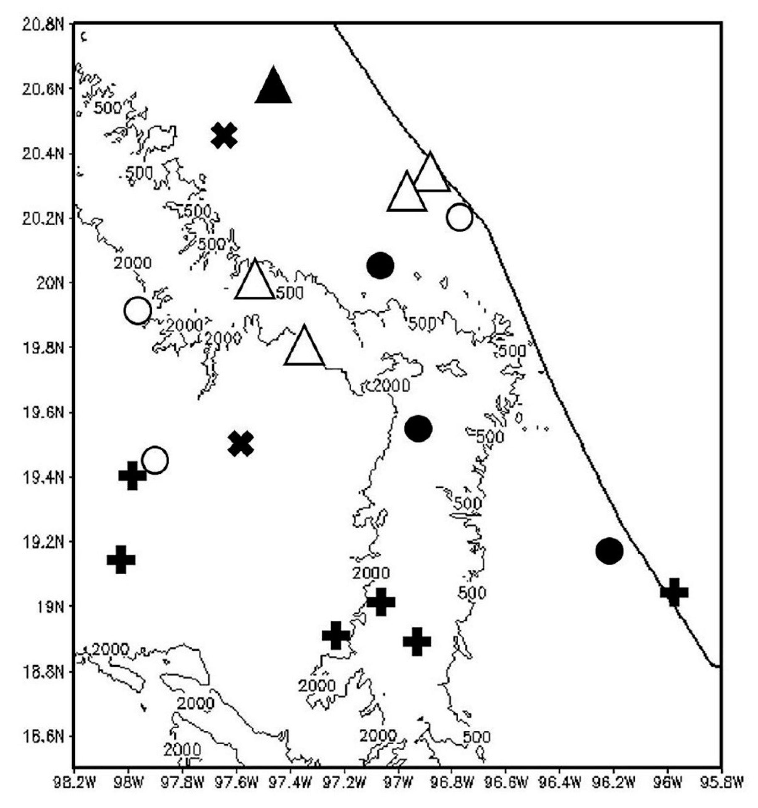
2.1. Observed Data
2.2. CMORPH Data
2.3. NARR Data
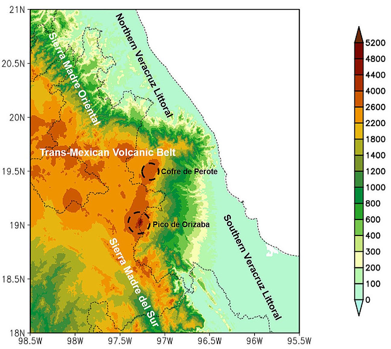
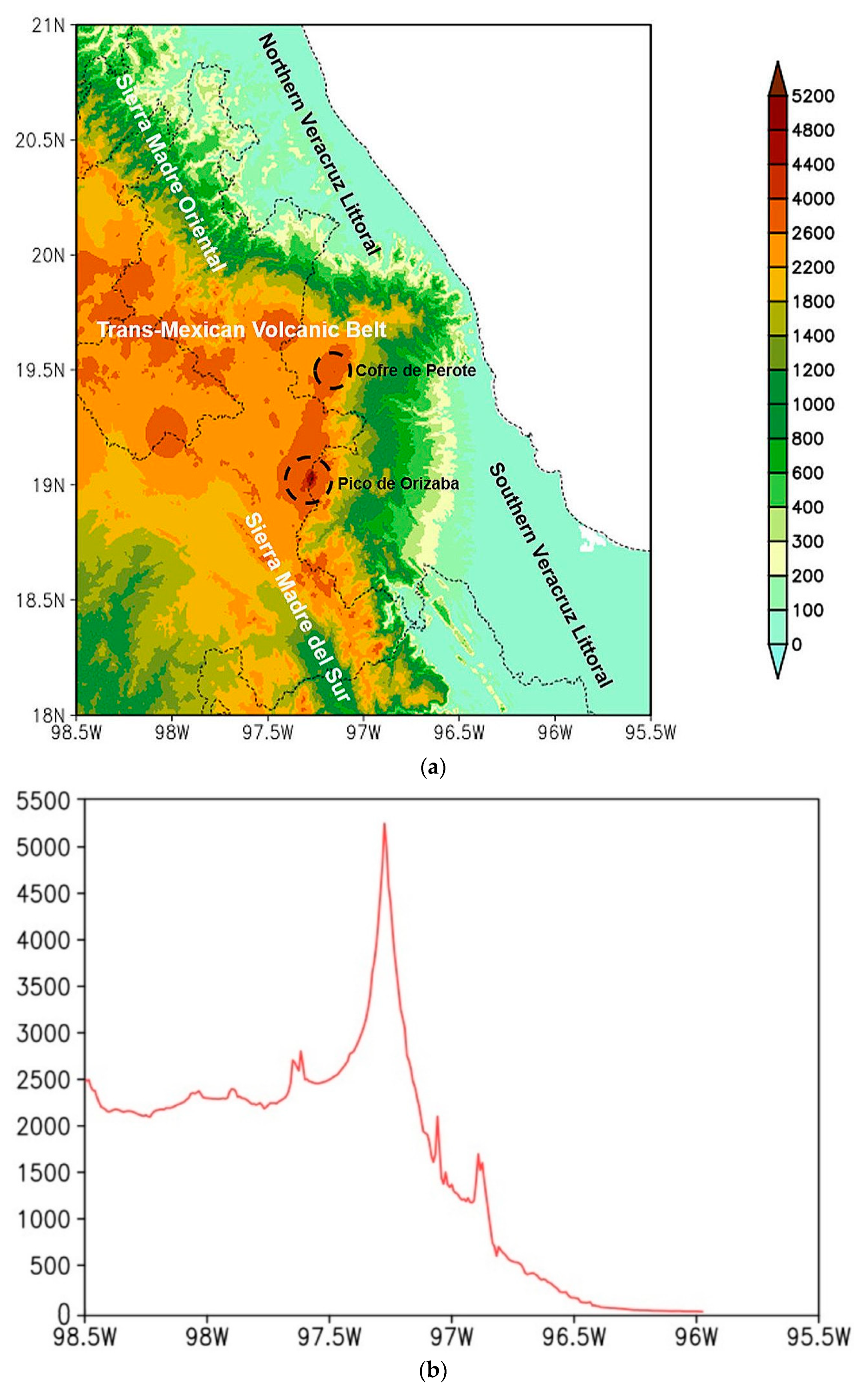
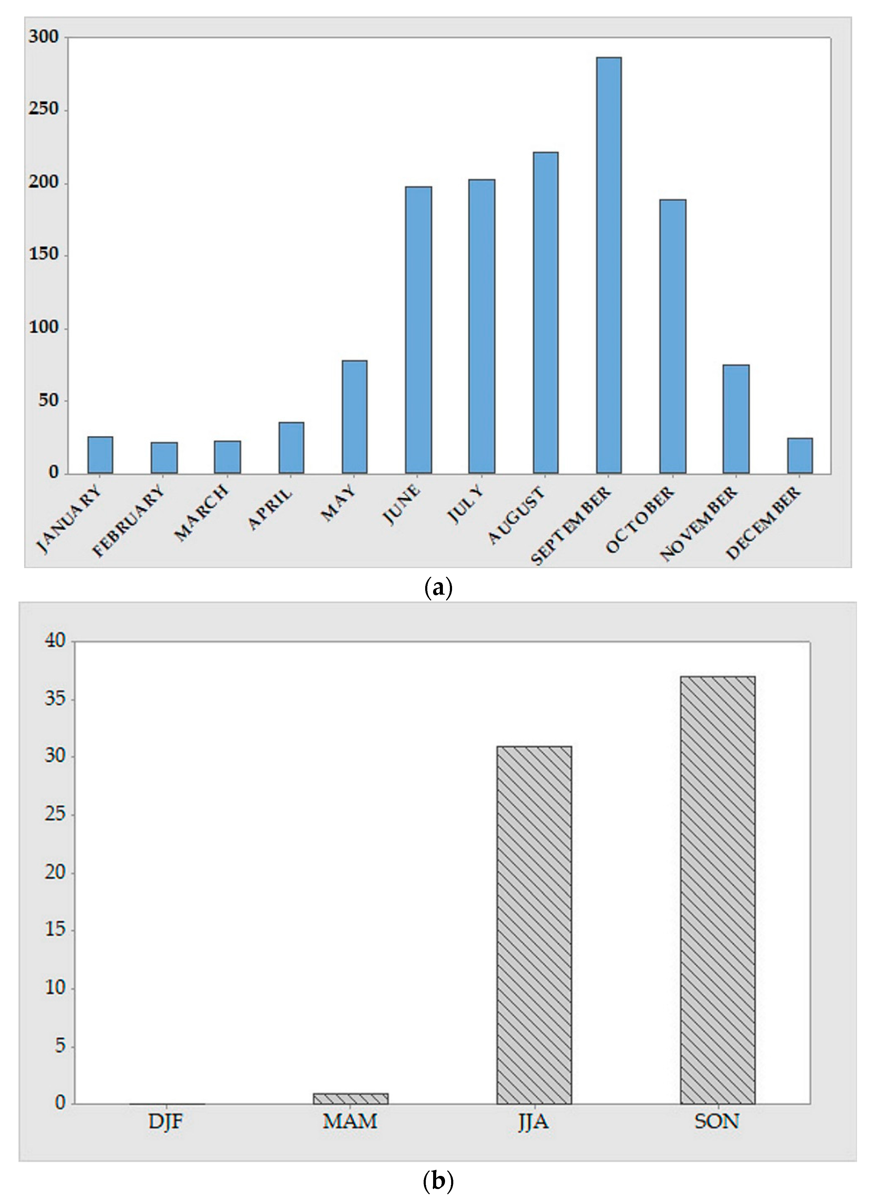
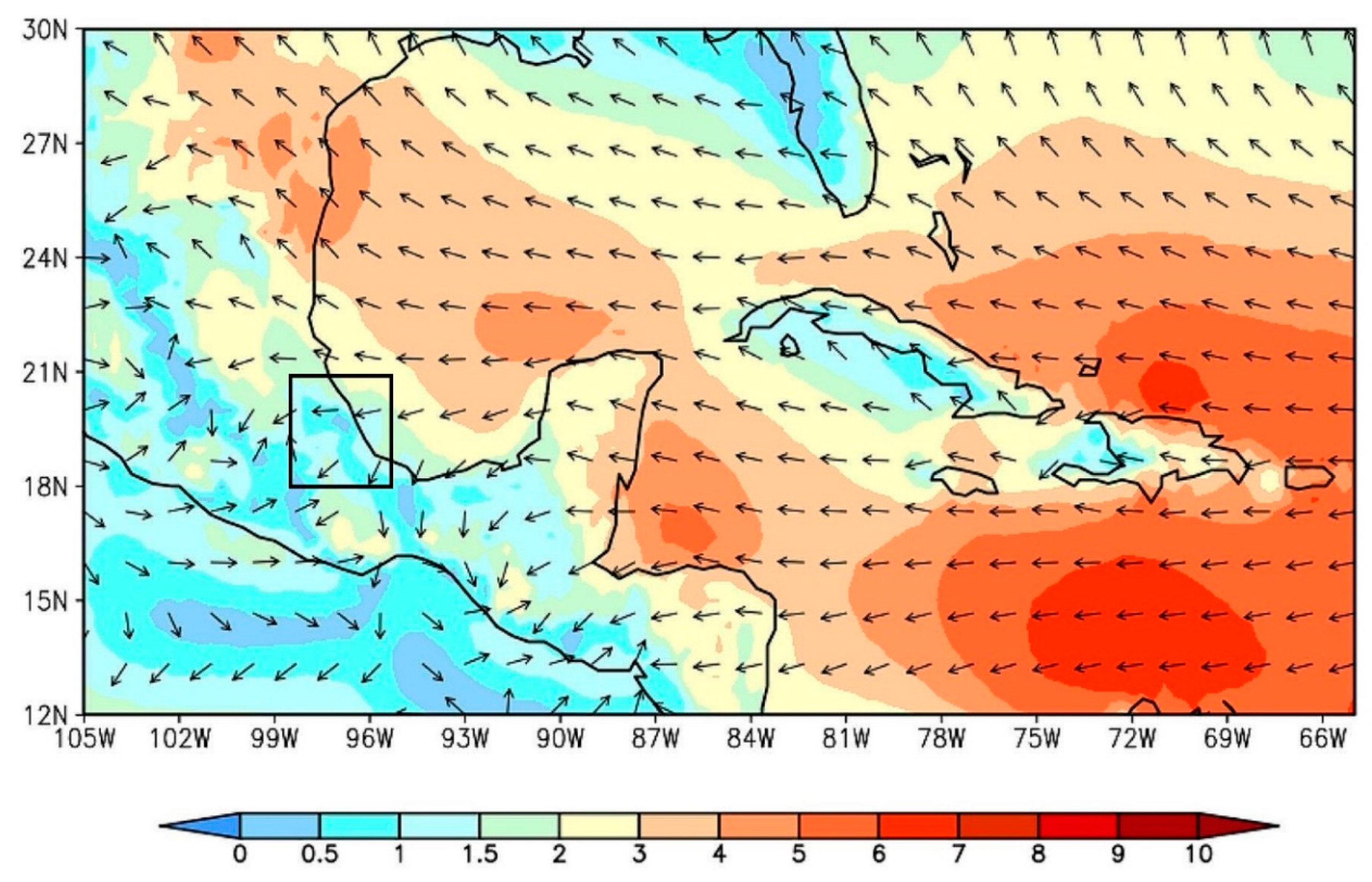
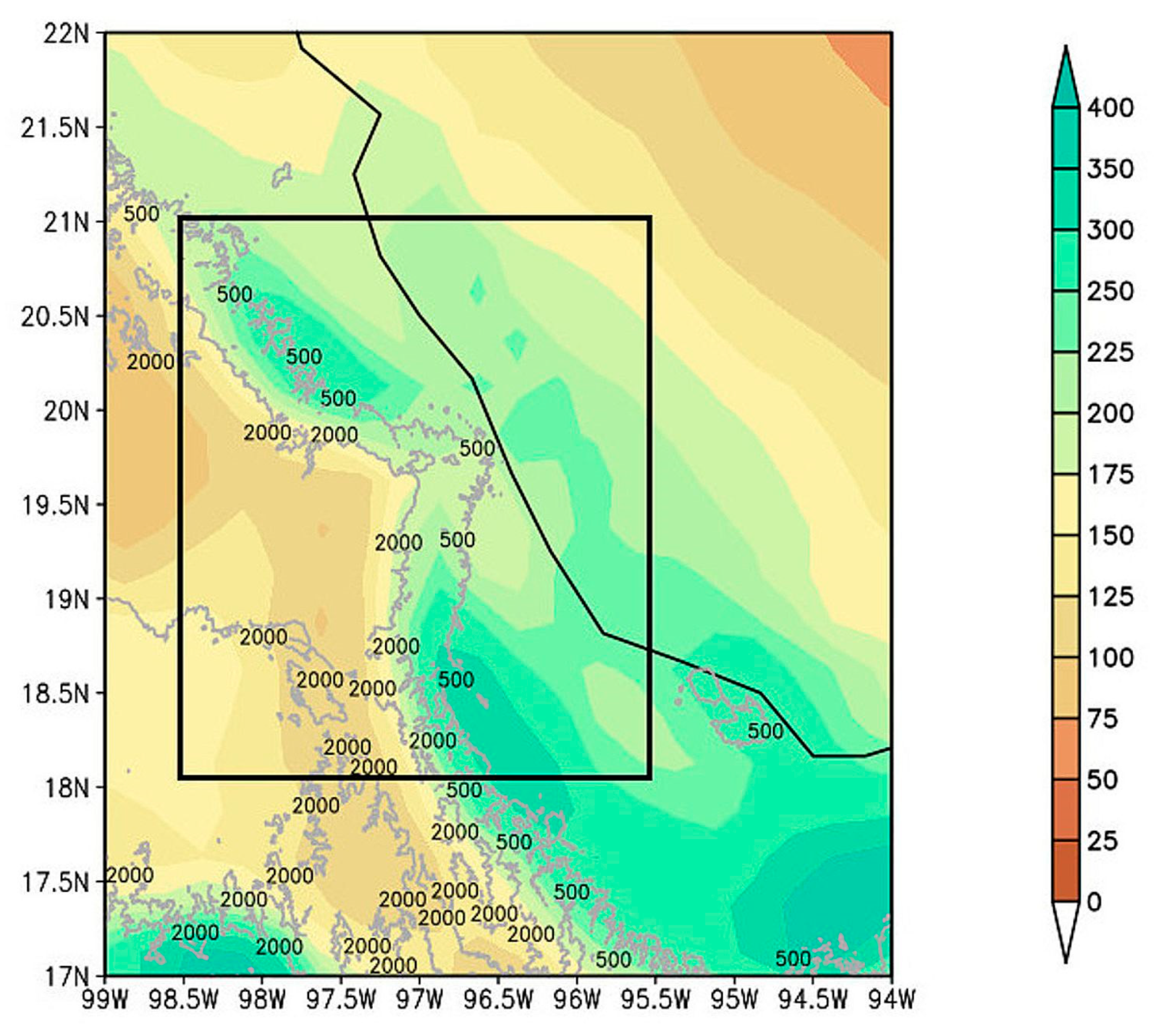
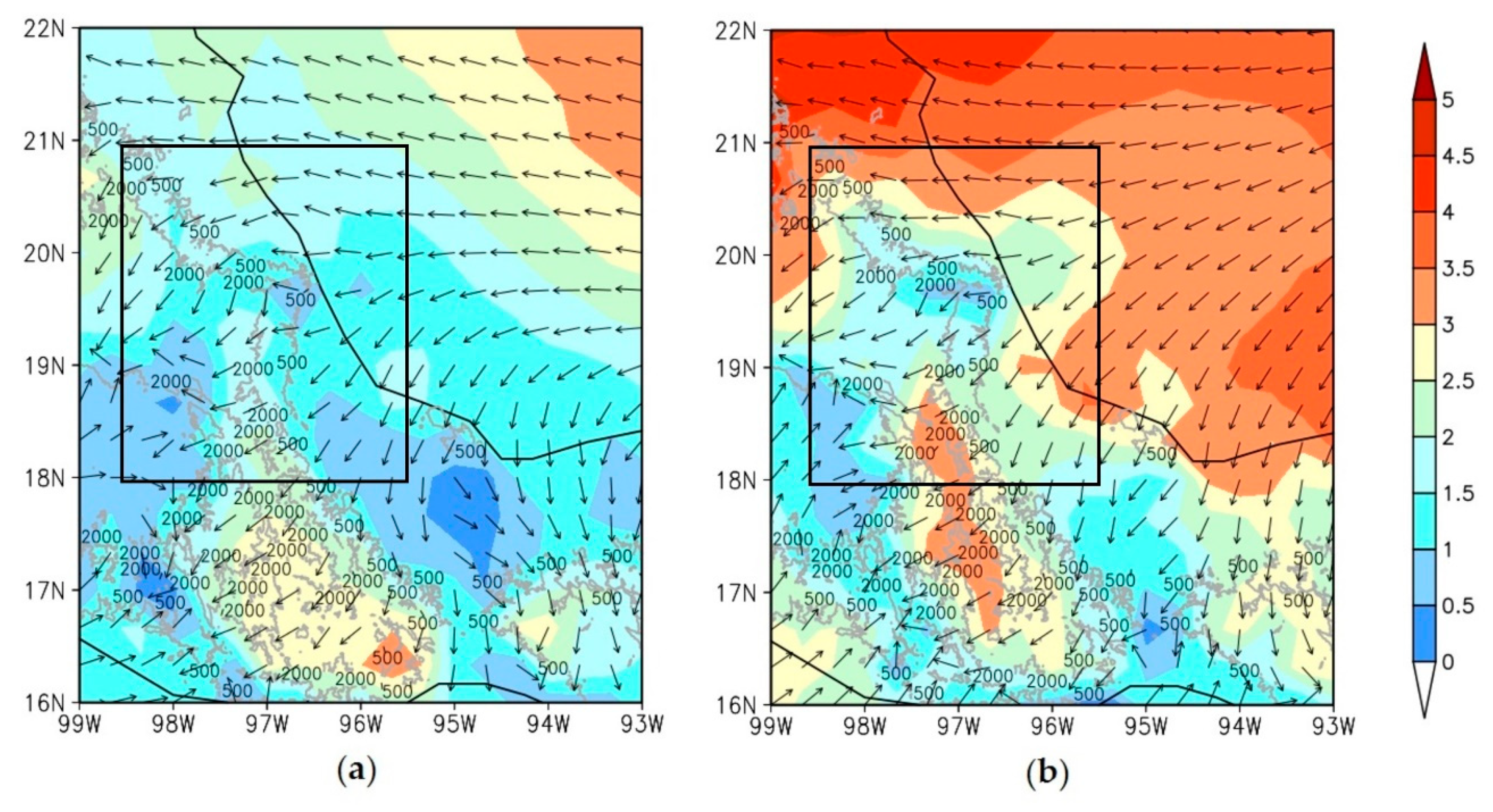
3. Regional Rainfall Climatology
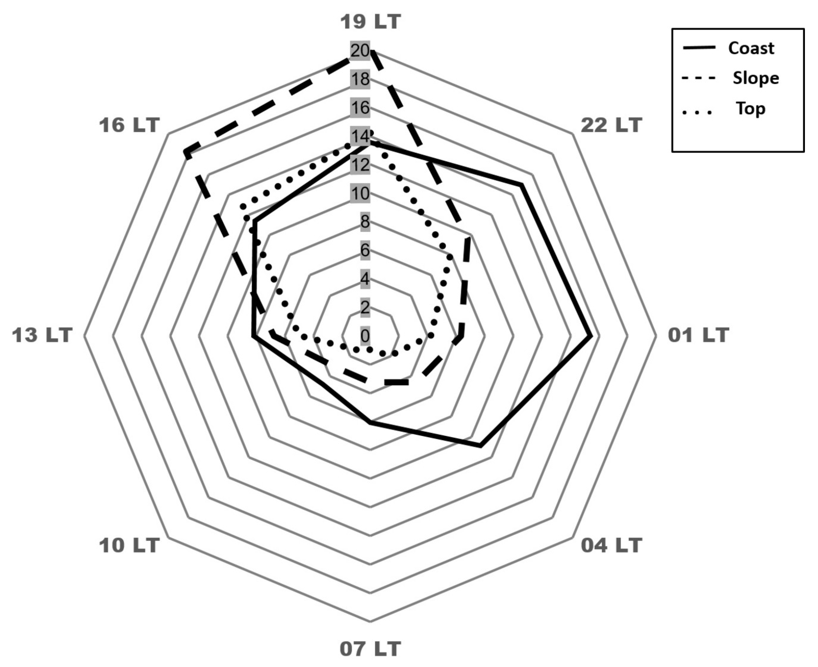
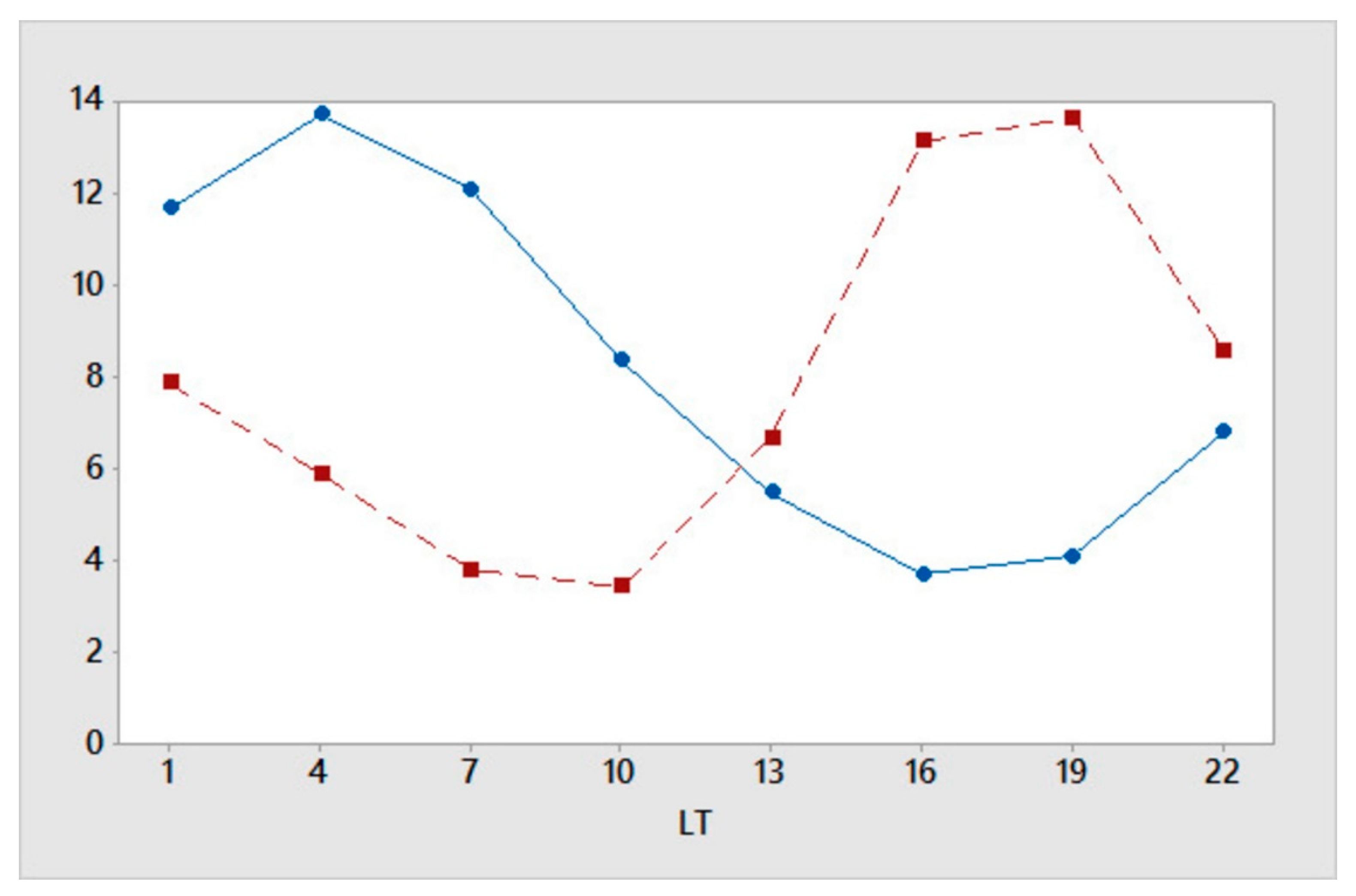
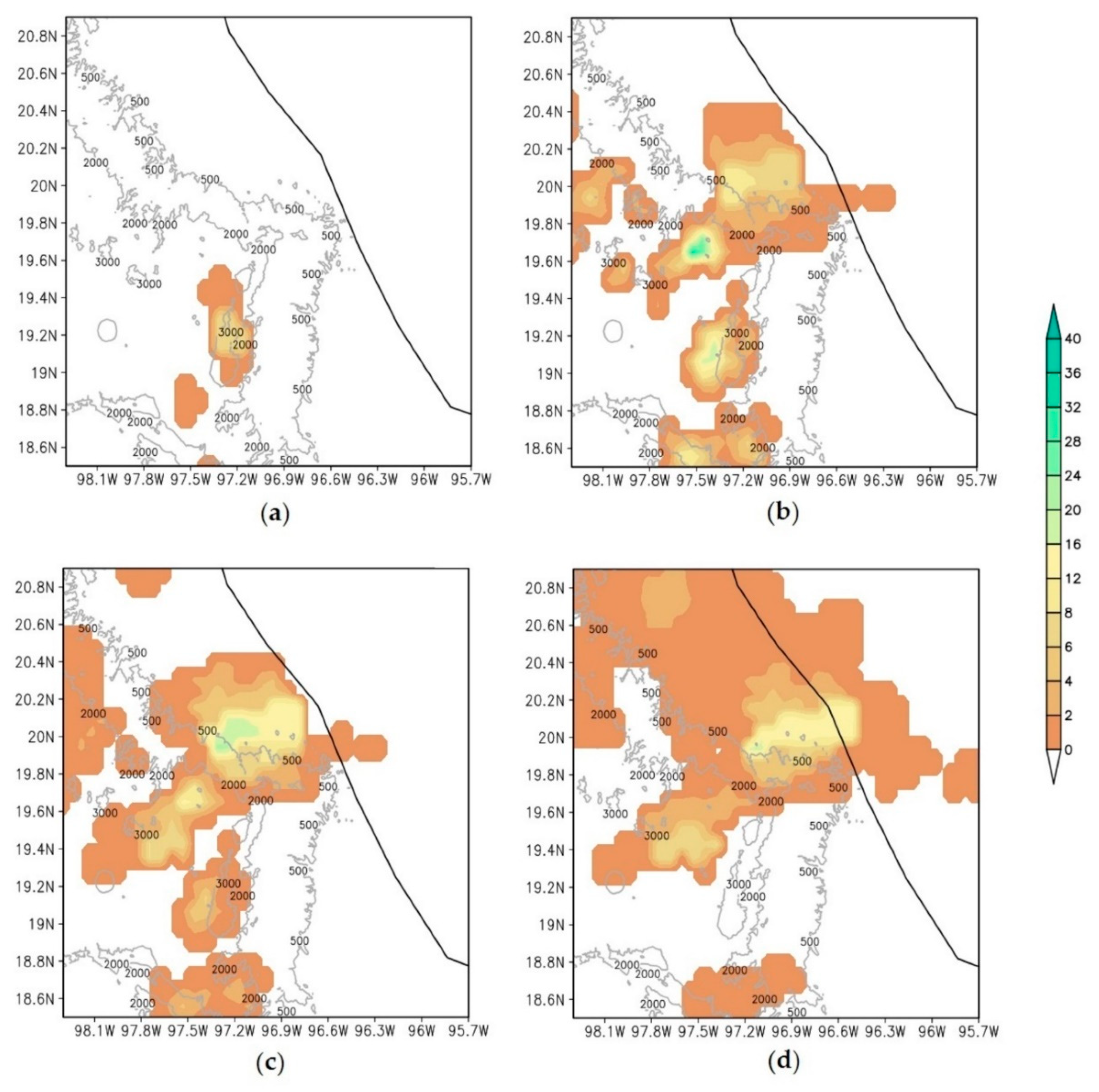
4. Diurnal Rainfall Cycle along the Coastal Plain
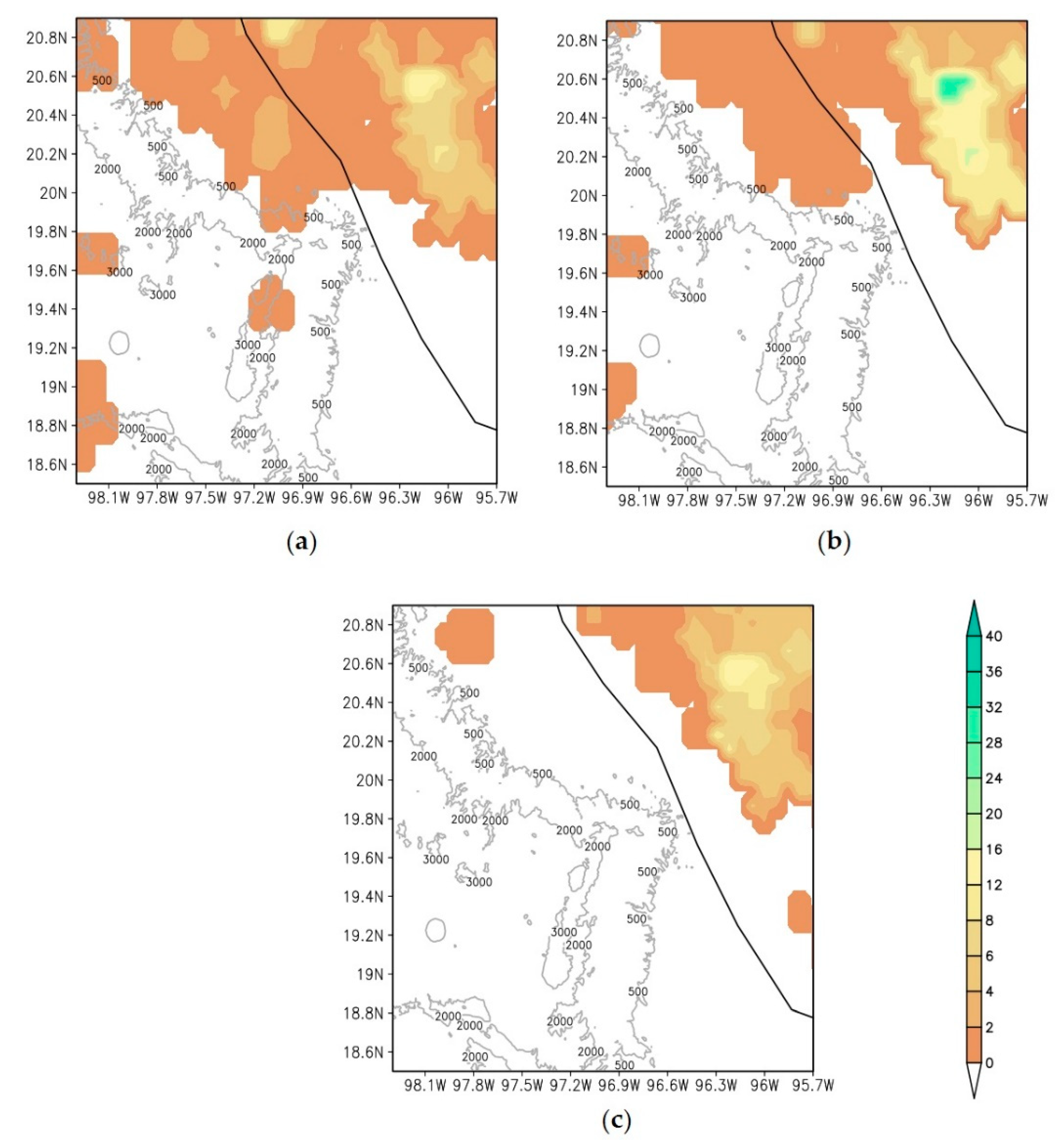
5. Case Studies
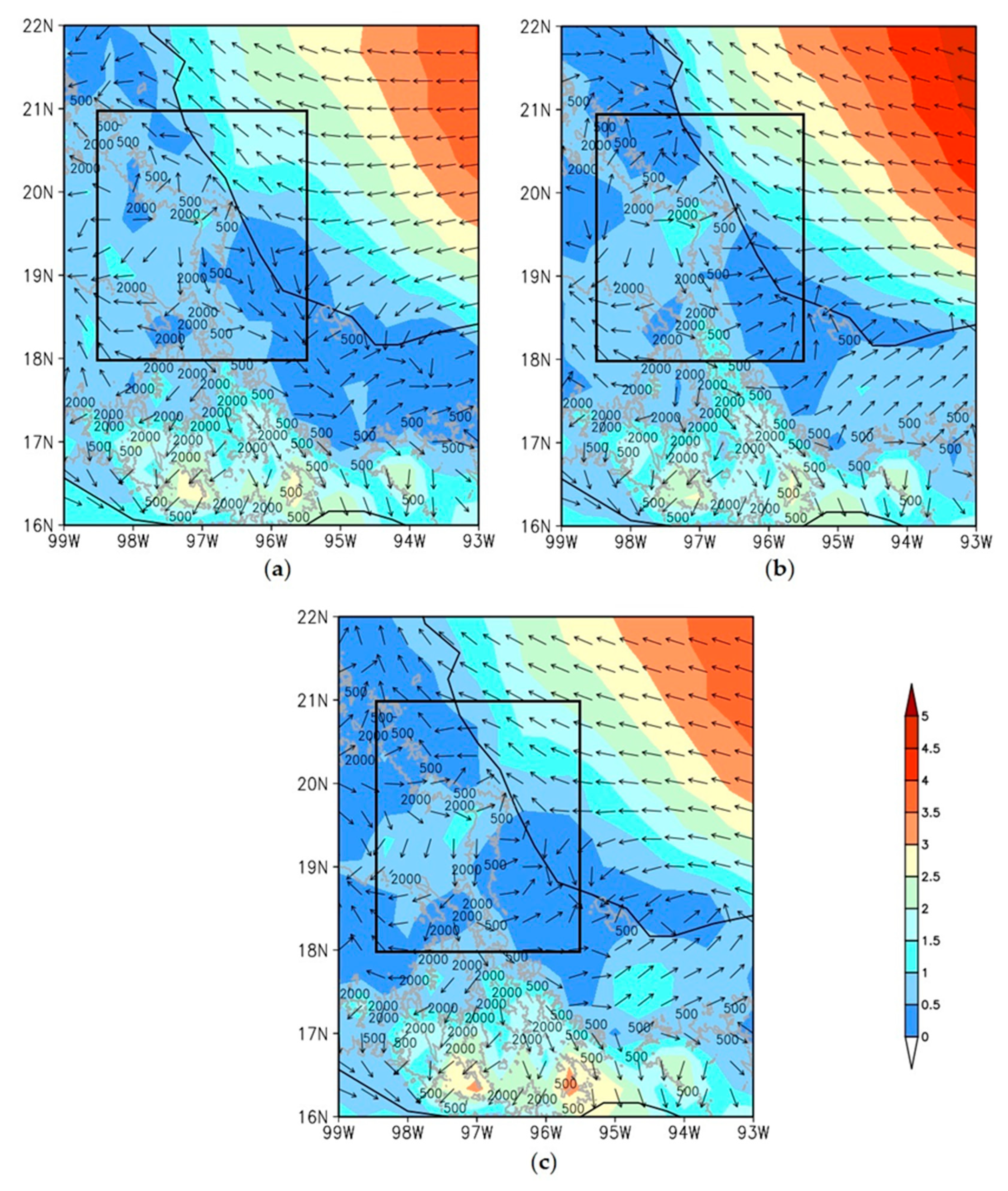
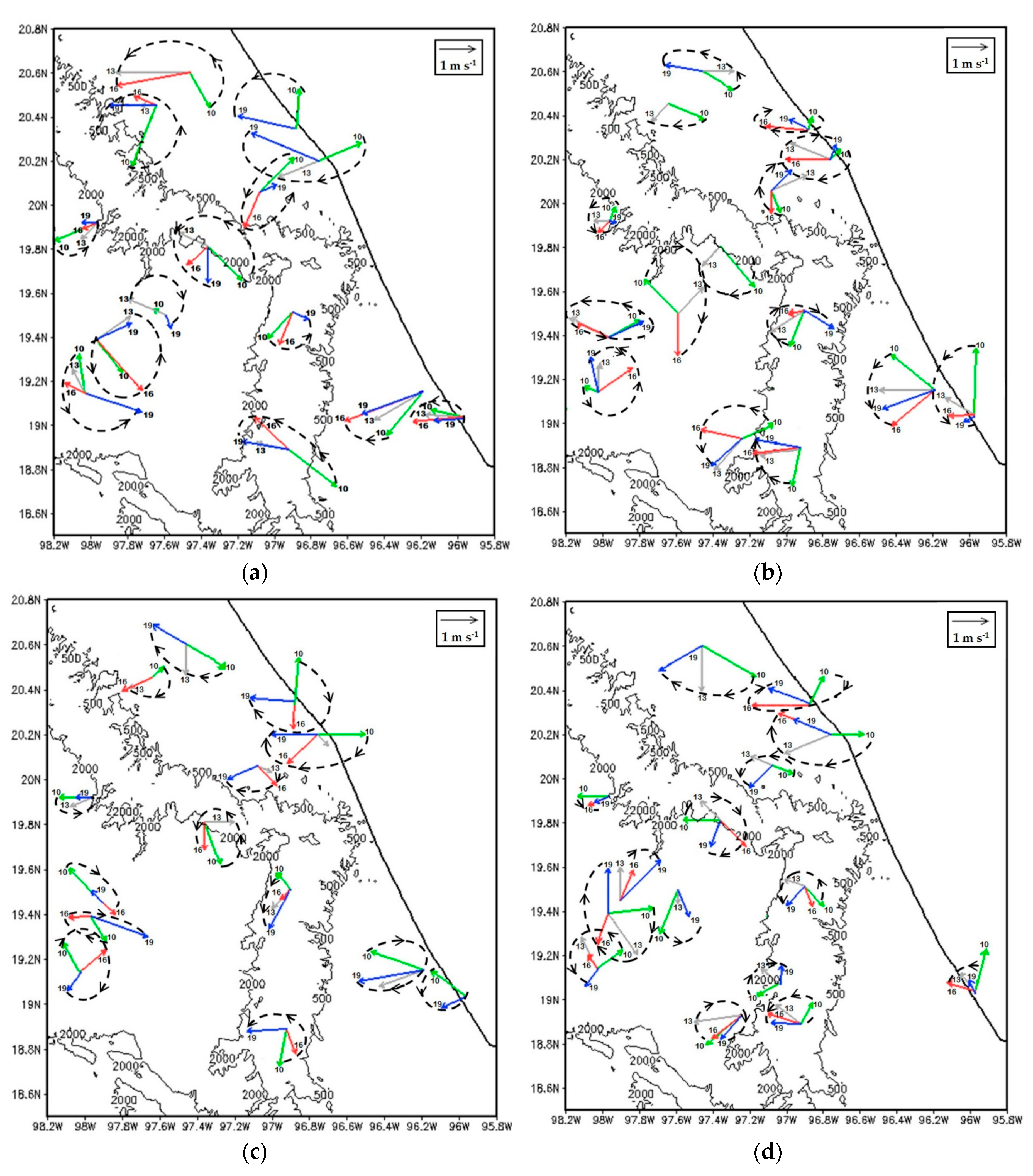
5.1. Local Circulation from 29 June to 2 July
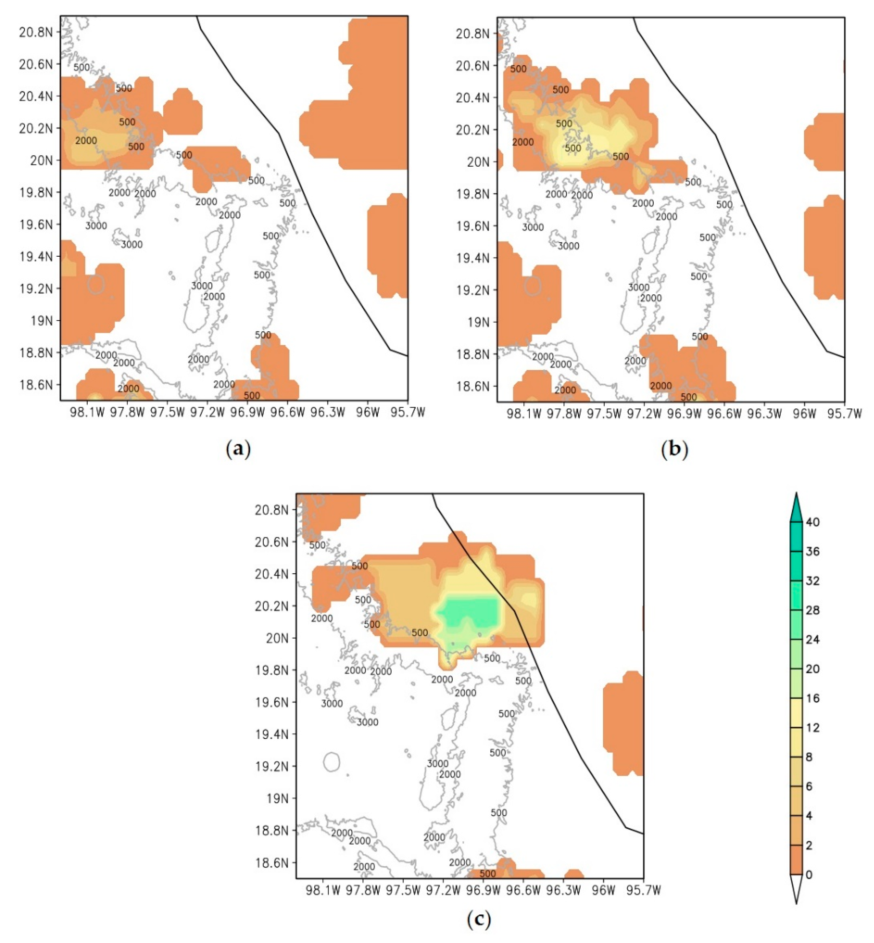
5.2. Evening and Nocturnal Rainfall Episodes
6. Conclusions
Author Contributions
Funding
Acknowledgments
Conflicts of Interest
Appendix A

| Authors | Rodgers et al. (2001) | Jiang and Zipser (2009) | Prat and Nelson (2013) | Khouakhi et al. (2017) |
|---|---|---|---|---|
| Contribution Month | to annual mean rainfall | to annual mean rainfall | to annual mean rainfall | to seasonal mean rainfall |
| DEC | 0% | 0% | 0% | 0% |
| JAN | 0% | 0% | 0% | |
| FEB | 0% | 0% | 0% | |
| MAR | 0% | 0% | 0% | 3% |
| APR | 0% | 0% | 0% | |
| MAY | 0% | 0% | 1% | |
| JUN | 1% | 2% | 2% | 15% |
| JUL | 3% | 3% | 2% | |
| AUG | 5% | 10% | 4% | |
| SEP | 6% | 20% | 11% | 20% |
| OCT | 6% | 7% | 6% | |
| NOV | 4% | 2% | 2% | |
| Focus domain | 100° W–50° W 5° N–35° N | 85° W–20° W 5° N–30° N | 130° W–50° W 0° N–50° N | Global |
| Period | 1988, 1989, and 1991–1998 | 1998–2000 and 2002–2006 | 1998–2009 | Data between 1970 and 2014 |
| Data | SSM/I (Special Sensor Microwave Imager)-derived | Tropical Rainfall Measuring Mission (TRMM) | Tropical Rainfall Measuring Mission (TRMM) Multi-satellite Precipitation Analysis (TMPA) product 3B42 | 18,607 global rain gauges |
References
- Houze, R.A.; Geotis, S.G.; Marks, F.D., Jr.; West, A.K. Winter monsoon convection in the vicinity of north Borneo. Part I: Structure and time variation of the clouds and precipitation. Mon. Weather Rev. 1981, 109, 1595–1614. [Google Scholar] [CrossRef]
- Garreaud, R.; Wallace, J.M. The diurnal march of convective cloudiness over the Americas. Mon. Weather Rev. 1997, 125, 3157–3171. [Google Scholar] [CrossRef]
- Dai, A.; Giorgi, F.; Trenberth, K.E. Observed and model-simulated diurnal cycles of precipitation over the contiguous United States. J. Geophys. Res. Atmos. 1999, 104, 6377–6402. [Google Scholar] [CrossRef]
- Ohsawa, T.; Ueda, H.; Hayashi, T.; Watanabe, A.; Matsumoto, J. Diurnal variations of convective activity and rainfall in tropical Asia. J. Meteorol. Soc. Jpn. Ser. II 2001, 79, 333–352. [Google Scholar] [CrossRef]
- Yang, G.-Y.; Slingo, J. The diurnal cycle in the tropics. Mon. Weather Rev. 2001, 129, 784–801. [Google Scholar] [CrossRef]
- Sorooshian, S.; Gao, X.; Hsu, K.; Maddox, R.; Hong, Y.; Gupta, H.V.; Imam, B. Diurnal variability of tropical rainfall retrieved from combined GOES and TRMM satellite information. J. Clim. 2002, 15, 983–1001. [Google Scholar] [CrossRef]
- Mapes, B.E.; Warner, T.T.; Xu, M.; Negri, A.J. Diurnal patterns of rainfall in northwestern South America. Part I: Observations and context. Mon. Weather Rev. 2003, 131, 799–812. [Google Scholar] [CrossRef]
- Yang, S.; Smith, E.A. Mechanisms for diurnal variability of global tropical rainfall observed from TRMM. J. Clim. 2006, 19, 5190–5226. [Google Scholar] [CrossRef]
- Kikuchi, K.; Wang, B. Diurnal precipitation regimes in the global tropics. J. Clim. 2008, 21, 2680–2696. [Google Scholar] [CrossRef]
- Bao, X.; Zhang, F.; Sun, J. Diurnal variations of warm-season precipitation east of the Tibetan Plateau over China. Mon. Weather Rev. 2011, 139, 2790–2810. [Google Scholar] [CrossRef]
- Huang, W.-R.; Wang, S.-Y. Impact of land–sea breezes at different scales on the diurnal rainfall in Taiwan. Clim. Dyn. 2014, 43, 1951–1963. [Google Scholar] [CrossRef]
- Lee, M.-I.; Schubert, S.D.; Suarez, M.J.; Held, I.M.; Kumar, A.; Bell, T.L.; Schemm, J.-K.E.; Lau, N.-C.; Ploshay, J.J.; Kim, H.-K. Sensitivity to horizontal resolution in the AGCM simulations of warm season diurnal cycle of precipitation over the United States and northern Mexico. J. Clim. 2007, 20, 1862–1881. [Google Scholar] [CrossRef]
- Sato, T.; Miura, H.; Satoh, M.; Takayabu, Y.N.; Wang, Y. Diurnal cycle of precipitation in the tropics simulated in a global cloud-resolving model. J. Clim. 2009, 22, 4809–4826. [Google Scholar] [CrossRef]
- Dirmeyer, P.A.; Cash, B.A.; Kinter, J.L.; Jung, T.; Marx, L.; Satoh, M.; Stan, C.; Tomita, H.; Towers, P.; Wedi, N. Simulating the diurnal cycle of rainfall in global climate models: Resolution versus parameterization. Clim. Dyn. 2012, 39, 399–418. [Google Scholar] [CrossRef]
- Nikulin, G.; Jones, C.; Giorgi, F.; Asrar, G.; Büchner, M.; Cerezo-Mota, R.; Christensen, O.B.; Déqué, M.; Fernandez, J.; Hänsler, A. Precipitation climatology in an ensemble of CORDEX-Africa regional climate simulations. J. Clim. 2012, 25, 6057–6078. [Google Scholar] [CrossRef]
- Wallace, J.M. Diurnal variations in precipitation and thunderstorm frequency over the conterminous United States. Mon. Weather Rev. 1975, 103, 406–419. [Google Scholar] [CrossRef]
- Oki, T.; Musiake, K. Seasonal change of the diurnal cycle of precipitation over Japan and Malaysia. J. Appl. Meteorol. 1994, 33, 1445–1463. [Google Scholar] [CrossRef]
- Chen, T.-C.; Yen, M.-C.; Hsieh, J.-C.; Arritt, R.W. Diurnal and seasonal variations of the rainfall measured by the automatic rainfall and meteorological telemetry system in Taiwan. Bull. Am. Meteorol. Soc. 1999, 80, 2299–2312. [Google Scholar] [CrossRef]
- Kishtawal, C.; Krishnamurti, T. Diurnal variation of summer rainfall over Taiwan and its detection using TRMM observations. J. Appl. Meteorol. 2001, 40, 331–344. [Google Scholar] [CrossRef]
- Mori, S.; Jun-Ichi, H.; Tauhid, Y.I.; Yamanaka, M.D.; Okamoto, N.; Murata, F.; Sakurai, N.; Hashiguchi, H.; Sribimawati, T. Diurnal land–sea rainfall peak migration over Sumatera Island, Indonesian Maritime Continent, observed by TRMM satellite and intensive rawinsonde soundings. Mon. Weather Rev. 2004, 132, 2021–2039. [Google Scholar] [CrossRef]
- Kousky, V.; Janowiak, J.; Joyce, R. The Diurnal Cycle of Precipitation over the Americas based on CMORPH. J. Geophys. Res. Atmos. 2005, 110. [Google Scholar] [CrossRef]
- Qian, J.-H. Why precipitation is mostly concentrated over islands in the Maritime Continent. J. Atmos. Sci. 2008, 65, 1428–1441. [Google Scholar] [CrossRef]
- He, H.; Zhang, F. Diurnal variations of warm-season precipitation over northern China. Mon. Weather Rev. 2010, 138, 1017–1025. [Google Scholar] [CrossRef]
- Singh, P.; Nakamura, K. Diurnal variation in summer precipitation over the central Tibetan Plateau. J. Geophys. Res. Atmos. 2009, 114. [Google Scholar] [CrossRef]
- Vidal, R. Las regiones climáticas de México: Temas selectos de geografía de México; Instituto de Geografía, UNAM: Ciudad de México, México, 2005. [Google Scholar]
- Ruiz-Barradas, A.; Tejeda-Martínez, A.; Miranda-Alonso, S.; Flores-Zamudio, R.H. Climatología. In Atlas del Patrimonio Natural, Histórico y Cultural de Veracruz; Florescano, E., Ortíz-Escamilla, O., Eds.; Gobierno del Estado de Veracruz y Universidad Veracruzana: Veracruz, Mexico, 2010; pp. 203–226. [Google Scholar]
- Jáuregui, E.; Soto, C. La Vertiente del Golfo de México, Algunos Aspectos Fisiográficos y Climáticos. BoletÍN Inst. Geogr. ÍA 1975, 6, 37–45. [Google Scholar]
- Mosiño, P.; García, E. The climate of Mexico. Climates of North America. World Surv. Climatol. 1974, 11, 345–404. [Google Scholar]
- Tejeda, A.; Méndez Pérez, I.R.; Utrera, A.; García Tello, L.G.; Mendoza, V.M. Circulación local y ascenso de aire en un sitio costero y tropical al pie de la montaña. El Clima Entre El Mar Y La Montaña 2004, 4, 145–154. [Google Scholar]
- Fitzjarrald, D.R. Slope winds in Veracruz. J. Clim. Appl. Meteorol. 1986, 25, 133–144. [Google Scholar] [CrossRef]
- Nesbitt, S.W.; Zipser, E.J. The diurnal cycle of rainfall and convective intensity according to three years of TRMM measurements. J. Clim. 2003, 16, 1456–1475. [Google Scholar] [CrossRef]
- Joyce, R.J.; Janowiak, J.E.; Arkin, P.A.; Xie, P. CMORPH: A method that produces global precipitation estimates from passive microwave and infrared data at high spatial and temporal resolution. J. Hydrometeorol. 2004, 5, 487–503. [Google Scholar] [CrossRef]
- Mesinger, F.; DiMego, G.; Kalnay, E.; Mitchell, K.; Shafran, P.C.; Ebisuzaki, W.; Jović, D.; Woollen, J.; Rogers, E.; Berbery, E.H. North American regional reanalysis. Bull. Am. Meteorol. Soc. 2006, 87, 343–360. [Google Scholar] [CrossRef]
- DeHart, J.C.; Houze, R.A., Jr. Orographic modification of precipitation processes in Hurricane Karl (2010). Mon. Weather Rev. 2017, 145, 4171–4186. [Google Scholar] [CrossRef]
- Breña-Naranjo, J.A.; Pedrozo-Acuña, A.; Pozos-Estrada, O.; Jiménez-López, S.A.; López-López, M.R. The contribution of tropical cyclones to rainfall in Mexico. Phys. Chem. Earth Parts A/B/C 2015, 83, 111–122. [Google Scholar]
- Jiang, H.; Zipser, E.J. Contribution of tropical cyclones to the global precipitation from eight seasons of TRMM data: Regional, seasonal, and interannual variations. J. Clim. 2010, 23, 1526–1543. [Google Scholar] [CrossRef]
- Prat, O.P.; Nelson, B.R. Mapping the world’s tropical cyclone rainfall contribution over land using the TRMM Multi-satellite Precipitation Analysis. Water Resour. Res. 2013, 49, 7236–7254. [Google Scholar] [CrossRef]
- Rodgers, E.B.; Adler, R.F.; Pierce, H.F. Contribution of tropical cyclones to the North Atlantic climatological rainfall as observed from satellites. J. Appl. Meteorol. 2001, 40, 1785–1800. [Google Scholar] [CrossRef]
- Khouakhi, A.; Villarini, G.; Vecchi, G.A. Contribution of tropical cyclones to rainfall at the global scale. J. Clim. 2017, 30, 359–372. [Google Scholar] [CrossRef]
- Malkus, J.S. On the Structure of the Trade Wind Moist Layer; Massachusetts Institute of Technology and Woods Hole Oceanographic Institution: Cambridge, MA, USA, 1958. [Google Scholar]
- Malkus, J.S. On the maintenance of the trade winds. Tellus 1956, 8, 335–350. [Google Scholar] [CrossRef]
- Satomura, T. Diurnal variation of precipitation over the Indo-China Peninsula. J. Meteorol. Soc. Jpn. Ser. II 2000, 78, 461–475. [Google Scholar] [CrossRef]
- Reed, R.J.; Jaffe, K.D. Diurnal variation of summer convection over West Africa and the tropical eastern Atlantic during 1974 and 1978. Mon. Weather Rev. 1981, 109, 2527–2534. [Google Scholar] [CrossRef]
- Jiang, X.; Lau, N.C.; Klein, S.A. Role of eastward propagating convection systems in the diurnal cycle and seasonal mean of summertime rainfall over the US Great Plains. Geophys. Res. Lett. 2006, 33. [Google Scholar] [CrossRef]
- Nesbitt, S.W.; Gochis, D.J.; Lang, T.J. The diurnal cycle of clouds and precipitation along the Sierra Madre Occidental observed during NAME-2004: Implications for warm season precipitation estimation in complex terrain. J. Hydrometeorol. 2008, 9, 728–743. [Google Scholar] [CrossRef]


| Source | Instrumentation | No. Stations |
|---|---|---|
| Mexican National Weather Service automatic weather stations | http://smn.cna.gob.mx/es/observando-el-tiempo/estaciones-meteorologicas-automaticas-ema-s | 6 |
| Regional Weather Underground cited stations | https://www.wunderground.com/weatherstation/overview.asp | 2 |
| Institute of Geography of the UNAM stations | Meteorological station Davis Vantage Pro 2. | 3 |
| Universidad Veracruzana Stations | Termohygrometric datalogger HOBO LCD Onset Computer Corp, model U14-001. High precision portable weather station SKYWATCH model GEOS N°11. | 3 |
| METAR data | Automated Surface Observing System (ASOS). | 1 |
© 2019 by the authors. Licensee MDPI, Basel, Switzerland. This article is an open access article distributed under the terms and conditions of the Creative Commons Attribution (CC BY) license (http://creativecommons.org/licenses/by/4.0/).
Share and Cite
Pérez-Méndez, M.; Tejeda-Martínez, A.; Fitzjarrald, D.R. Diurnal Variation of Rainfall in a Tropical Coastal Region with Complex Orography. Atmosphere 2019, 10, 604. https://doi.org/10.3390/atmos10100604
Pérez-Méndez M, Tejeda-Martínez A, Fitzjarrald DR. Diurnal Variation of Rainfall in a Tropical Coastal Region with Complex Orography. Atmosphere. 2019; 10(10):604. https://doi.org/10.3390/atmos10100604
Chicago/Turabian StylePérez-Méndez, Martha, Adalberto Tejeda-Martínez, and David R. Fitzjarrald. 2019. "Diurnal Variation of Rainfall in a Tropical Coastal Region with Complex Orography" Atmosphere 10, no. 10: 604. https://doi.org/10.3390/atmos10100604
APA StylePérez-Méndez, M., Tejeda-Martínez, A., & Fitzjarrald, D. R. (2019). Diurnal Variation of Rainfall in a Tropical Coastal Region with Complex Orography. Atmosphere, 10(10), 604. https://doi.org/10.3390/atmos10100604