Article

Geophysical and Remote Sensing Techniques for Large-Volume and Complex Landslide Assessment

1
Department of Earth Sciences, Sapienza University of Rome, 00185 Rome, Italy
2
CERI Research Center, Sapienza University of Rome, Piazzale Aldo Moro 5, 00185 Rome, Italy
3
Department of Psychological, Health and Territorial Sciences, Gabriele D’Annunzio University of Chieti-Pescara, 66013 Chieti, Italy
4
Special Office for the Reconstruction—Earthquake-2016 Extraordinary Commissary, Bureau of the Council of Ministers, 00187 Rome, Italy
5
Trigeo s.n.c., Soci, 52011 Arezzo, Italy
*
Author to whom correspondence should be addressed.
Remote Sens. 2025, 17(12), 2029; https://doi.org/10.3390/rs17122029
Submission received: 9 May 2025 / Revised: 9 June 2025 / Accepted: 11 June 2025 / Published: 12 June 2025

Abstract

:
Landslides pose significant risks to human life and infrastructure, driven by a complex interplay of geological and hydrological factors. This study investigates the ongoing slope instability affecting the village of Borrano, in Central Italy, where large-scale landslides are triggered or reactivated by extreme rainfall and seismic activity. A multidisciplinary approach was employed, integrating traditional geological surveys, direct investigations, and advanced geophysical techniques—including electrical resistivity tomography (ERT) and seismic refraction tomography (SRT)—to characterize subsurface structures. Additionally, Sentinel-1 interferometric synthetic aperture radar (InSAR) was employed to parametrize the deformation rates induced by the landslide. The results reveal a complex geological framework dominated by the Teramo Flysch, where weak clayey facies and structurally controlled dip-slopes predispose the area to gravitational instability. ERT and SRT identified resistivity and velocity contrasts associated with shallow and depth sliding surfaces. At the same time, satellite-based synthetic aperture radar (SAR) data confirmed persistent slow movements, with vertical displacement rates between −10 and −24 mm/year. These findings underscore the importance of lithological heterogeneity and structural settings in the evolution of landslides. The integrated geophysical and remote sensing approach enhances the understanding of slope dynamics. It can be used to cross-check interpretations, capture displacement trends, characterize the internal structure of unstable slopes, and resolve the limitations of each method. This synergy provides a more comprehensive assessment of complex slope instability, offering valuable insights for hazard mitigation strategies in landslide-prone areas.

1. Introduction

1.1. Large-Volume Landslide Background

Landslides are natural and human-induced geomorphological processes caused by surface and/or deep deformation under the force of gravity. They represent a significant threat to human life, infrastructure, and livelihoods. Indeed, landslides can cause widespread destruction, including the loss of buildings, roads, and entire communities [1,2]. Deep-seated gravitational slope deformations (DsGSDs) present a unique set of challenges due to their extensive dimensions, prolonged temporal evolution, and frequently imperceptible surface indicators [3,4,5,6]. These large-scale phenomena are characterized by the progressive displacement of huge masses of soil and rock, which create long-term hazards and lead to the gradual but persistent degradation of land, the disruption of infrastructure, and eventual threats to built-up areas. Under specific conditions, they often evolve into more dramatic events [7,8,9]; in fact, their widespread extent can pose a risk to entire communities. These phenomena have been observed in the Apennine region of Italy, where many settlements and part of the infrastructure have been built on or near slopes that are slowly deforming [10,11,12,13]. These movements, which typically occur at rates ranging from a few millimeters to a few centimeters per year, are influenced by a combination of geological, tectonic, seismic, and hydrological factors. Geological frameworks, such as planes of stratification and pre-existing structural weaknesses, play a crucial role in this process by acting as slip surfaces or zones of weakness [4,8,14,15,16]. Similarly, geomorphological factors, such as slope and geometry, influence deformation patterns, which are often observed even on moderately steep slopes [5,17,18,19]. In tectonically active regions, the presence of faults and fractures increases susceptibility to landslides, as seismic events can trigger or speed up deformation by causing changes in stress and pore pressure [4,10]. In addition, hydrological factors, particularly water infiltration, reduce material strength, thereby reducing stability and triggering deep movement [14,20,21,22]. Furthermore, identifying and monitoring DsGSDs is often difficult as erosion and alteration processes mask some of the morphological traces of surfaces [4,23,24].

1.2. Geological, Geophysical, and SAR Investigation for Slope Instability Characterization

A multidisciplinary approach is required to study the evolution of DsGSDs involving large volumes of land, integrating surface geology and geomorphology with subsurface investigations (particularly geophysical ones) and remote sensing to accurately characterize deformations and their evolution [4,7,16,25,26]. Surface geological surveys and geognostic investigations can provide direct evidence of stratigraphy and deformation planes. These surveys can identify active deformation, and the morphological features associated with it, such as tensile zones, escarpments, counter slopes, and summit depressions [8,27,28,29]. These studies help to define the extent and activity level of landslides, complementing geomorphological analyses based on high-resolution digital elevation models (DEMs). Indeed, high-resolution DEMs combined with direct geological observation allow for the detailed mapping of morphological structures, providing an initial characterization of them [6,30]. Boreholes, on the other hand, provide direct access to the subsurface, and are often equipped with instrumentation that can monitor deformation and groundwater flow at depth in real time [31,32,33]. These data are essential for defining the hydraulic characteristics of the subsurface and for correlating them with sliding surfaces, both for subsequent numerical modeling and for slope stability assessment [34].
For complex systems involving large volumes of soil, combining borehole investigations with geophysical survey methodologies improves the accuracy with which the extent and direction of DsGSD movement can be defined. Geophysical methods are essential for mapping subsurface structures in detail, revealing stratigraphic and structural configurations even at great depths [32]. These techniques, which include methods such as electrical resistivity tomography (ERT) and seismic surveys, enable non-invasive exploration of the subsurface. Seismic surveys and ERT provide valuable insights into the mechanical response of the materials to seismic waves and their electrical resistivity characteristics, thereby enhancing the overall understanding of subsurface properties [20,21,31,35]. Geophysical methods can reveal hidden geological features that might otherwise remain undetected through surface observations alone by capturing variations in the electrical conductivity and propagation velocities of seismic waves in soils [17,24,36]. ERT is a widely used technique for mapping variations in subsurface resistivity. It provides information on lithological heterogeneity, water saturation levels, and the geometry of sliding surfaces [7,37,38,39]. ERT is effective in delineating the buried morphology of landslides and the depth of sliding surfaces, as demonstrated in Hunan Province, China [40]. In the Thompson River valley in British Columbia, geophysical profiles revealed curvilinear features related to rotational–translational failure planes [41]. This technique is particularly effective in characterizing clay-rich zones and can highlight displaced portions of material [34,42]. Active and passive seismic methods, including seismic refraction, reflection, and ambient noise tomography, are more suitable, however, for evaluating subsurface stratigraphy, fault systems, and seismic and elastic material properties [43,44]. These techniques provide critical data on shear wave velocities, which are often correlated with material stiffness and susceptibility to deformation. In the case of an active landslide in North Yorkshire, UK, for example, seismic refraction tomography (SRT) provided valuable information on the volumetric characteristics of the subsurface affected by the phenomenon [24]. Scientific studies and research have demonstrated that integrating geophysical techniques with traditional field surveys improves the accuracy of geological models and enables a more comprehensive understanding of complex phenomena [6,16,32,45]. Furthermore, advances in synthetic aperture radar (SAR) techniques have revolutionized this approach even further [46]. SAR imaging offers a unique ability to monitor large-scale surface movements over time. This makes it a powerful tool for identifying the triggers of instability, which may be related to seismic activity, prolonged rainfall, or water infiltration, as well as the reactivation mechanisms involved [5,23,30]. By measuring ground displacement with millimeter accuracy over large areas, InSAR can detect deformation trends and identify acceleration phases, as well as map spatial displacement patterns. Time-series analyses, such as persistent scatterer interferometry (PSI), enable strain rates to be assessed over long periods, providing information on the dynamics of slow-moving active landslides [3,9,47]. There are countless interesting cases of gravity phenomena being analyzed using the abovementioned techniques in combination [22,27,33,48,49].

1.3. Case Study

Interferometric and geophysical techniques were integrated and applied to the case of Borrano, which is located approximately 2 km east of Civitella del Tronto in Central Italy. The area is seismically active and has experienced numerous landslides over time, causing significant damage to the local population [50]. It is in a landscape characterized by steep hills, with altitudes ranging from 300 to 430 m above sea level, within the Salinello River basin, which flows slightly further north. Gravitational instability phenomena, often of a complex nature, affect the entire territory of Civitella del Tronto. The types of landslides observed, the sliding surfaces, the volumes of material involved, and the geometries of the phenomena are all extremely variable, as are the triggers. In 2017, numerous active landslides related to extreme weather events and significant seismic activity were observed in the study area. The observed deformation mechanisms differed between deep rotary and translatory movements and slow DsGSD-type phenomena. Due to the geological complexity of the area and the presence of an objective risk to the population, an extremely detailed study was conducted by combining geological and geognostic surveys with the previously described geophysical and satellite monitoring techniques. To support the interpretation of ongoing landslide activity in the Borrano area, we have incorporated a series of photographic records documenting visible surface effects.
This research aims to develop a robust framework for investigating unstable slopes, with ERT and SAR data serving as the primary investigative drivers. The objective is to characterize the internal structure of landslides, delineate subsurface discontinuities that govern their kinematics, map the geometry and volume of the landslide body, identify potential sliding surfaces, and quantify deformation rates. To enrich and validate this interpretation, SRT data, geological information, and borehole data are used as complementary sources in the investigation of both shallow and DsGSD-type phenomena. When interpreted within the broader geological context, this integrated evidence aims to support the formulation of a well-grounded hypothesis on the origin of the observed displacement processes. The integrated approach of geophysics and remote sensing aims to enrich the understanding of slope dynamics, enabling cross-validation of interpretations and resolution of the limitations inherent to each method.

2. Materials and Methods

2.1. Geological and Morphological Reconstruction

The village of Borrano, situated in the province of Teramo, within the Abruzzo region, is located in the central part of the Italian peninsula (Figure 1a). The geological and morphological reconstruction of the study area was based on a combination of pre-existing data and new investigations. A total of six continuous core drills were performed: three during the initial campaign in 2018, prompted by structural damage following the 2016/2017 seismic events, and an additional three during a subsequent campaign in 2023 to enhance stratigraphic understanding (Figure 1b). The spatial distribution of boreholes reflects the need to ensure homogeneous coverage of the urban settlement, taking into account area accessibility. Figure 1c,d respectively illustrate the sequence of lithotypes encountered at the six geological boreholes (BH1–BH6) and an image of a core box, distinguishing the pelitic and arenaceous facies sampled in the boreholes. The execution of the geological boreholes was part of a scientific collaboration between the Department of Civil Protection and the University of Chieti–Pescara.
Data collection through direct investigations was complemented by a simultaneous and large-scale detailed geological survey to reconstruct a comprehensive conceptual model of the local stratigraphic framework. This approach had the goal of identifying key geological units, their spatial distribution, and the structural characteristics that influence the site’s stability.
By combining field observations with advanced analytical techniques, the model aimed to provide a nuanced representation of the subsurface, capturing the horizontal and vertical stratigraphic variability essential for understanding the dynamic processes at play. These data were integrated with high-resolution digital elevation models (DEMs), constructed using vector layers from the Abruzzo Region open data portal [51] and LIDAR data provided by the Ministry of Environment and Energy Security [52]. The datasets were processed, filtered, and interpolated to produce a detailed 3D terrain reconstruction, consisting of a triangular mesh covering the entire area of interest.
Morphometric analyses, including slope gradient and relief energy calculations, were performed using this DEM. The gradient of the slope was derived from the tangent plane in the direction of maximum steepness for each cell, applying a spatial window of nine elements. This analysis aimed to provide dominant slope classes in the area and critical insights into the evolution of large-scale morphometric systems, offering an effective framework for understanding both topographical features and geomorphological processes. This methodology had the purpose of highlighting the interconnections between geological and morphological features, serving as a foundation for the subsequent interpretation of indirect geophysical and remote sensing data and ensuring that all components of the study were firmly grounded in a robust geological background and geomorphological context.

2.2. Geophysical and Satellite Analyses

Geophysical and satellite-based analyses were employed for characterizing subsurface structures and surface-deformation dynamics.
As a preliminary step, ERT and SRT investigations were carried out simultaneously to evaluate the feasibility of distinguishing subsurface lithotechnical units and spatially discriminating between surface and profound instability phenomena by analyzing electrical resistivity and P-wave velocity variations. This initial calibration phase, conducted in May 2023, included a single ERT profile (ERT-A: 710 m, 72 electrodes with 10 m spacing), which partially overlapped with the SRT line B–B’. The investigation aimed to identify the most suitable methodology for the complex geological setting and associated instability scenario, refine acquisition parameters for subsequent surveys, and achieve high-resolution characterization of subsurface structures. Building upon the insights gained from this preliminary phase, the second characterization stage was designed and implemented. This phase introduced four additional profiles, ERT-1 to ERT-4, ranging from 550 m to 590 m in length, all maintaining a 10 m electrode spacing (Figure 2). The ERT and SRT arrays were arranged to intersect the stratigraphic logs, where possible, to cross-correlate seismic and resistivity signals with lithological observations and validate the geophysical findings.
The seismic refraction method was conducted using vertical 4.5 Hertz geophones. A total of 24 geophones were installed along a 240 m profile line, spaced 10 m apart. Nine hammer shots were employed, evenly distributed at 30 m intervals along the profile. The first shot was positioned at −6 m from the first geophone, while the ninth shot was placed at +6 m beyond the last geophone. This technique aimed to identify subsurface velocity contrasts, providing information on the extent and depth of potential instability zones. A geo-resistivimeter with 96 electrodes and 10 channels was utilized to perform electrical resistivity measurements. The Wenner and pole–dipole configurations were adopted as the electrode arrays, allowing for a balance between the resolution and depth of investigation. The data collected were processed using ErtLAB software [53], enabling the creation of a 3D model and 2D sections derived from the survey data. This processing employed the inversion method, which converts apparent resistivity values into true resistivity values that are representative of the investigated subsurface. This non-invasive geophysical technique was employed to investigate the electrical conductivity distribution in the subsurface by injecting an electrical current through steel electrodes and recording the resulting potential differences. The recorded data were analyzed to detect resistivity contrasts, which can be attributed to variations in lithology, instability phenomena, and groundwater content. The correlation of lithological interfaces identified during geological drilling with contrasts in electrical properties was performed to delineate and identify potential failure planes. Two-dimensional ERT profiles were used to depict both shallow and deep landslide bodies, reveal the potential location of sliding surfaces, and locally distinguish resistivity contrasts driven by the lithological nature of the subsurface. The processing of 3D-inverted geoelectrical data focused on identifying deeper landslide bodies using resistivity isosurfaces, while also estimating the volumes potentially impacted by large-scale mass movements on-site. An isosurface is the three-dimensional analog of an isoline. It represents a surface connecting points within a volume where a given scalar field (e.g., resistivity) has a constant value. In mathematical terms, it is a level set of a continuous function defined over a three-dimensional domain. The extrapolation of resistivity values from the three-dimensional analysis domain onto horizontal slices at different elevations aimed to spatially map the electrical conductivity contrasts, providing valuable insights into the subsurface structure and hydrogeological conditions. This approach had the goal of providing a detailed understanding of the site’s stratigraphy and the factors influencing its stability. Also, geophysical data were incorporated into geological cross-sections, integrating field-derived and geoelectric interpretations to refine the subsurface model.
Satellite analyses employed interferometric synthetic aperture radar (InSAR) to monitor surface deformation. Sentinel-1 radar datasets, covering the period from January 2021 to December 2022 with a temporal resolution of 12 days and perpendicular baselines within ±100 m, were acquired from the Alaska satellite facility portal [54]. The datasets, from both ascending and descending orbits, were processed using SNAP [55] and StaMPS [56] software to identify persistent scatterers (PSs)—radar targets maintaining phase stability across temporal acquisitions. The PS time-series data were homogenized on a 20 × 20 m regular grid, and displacement vectors were decomposed to extract the vertical (up-down) component. The point-based analysis of SAR displacement analysis aimed to provide critical insights into the temporal evolution and spatial distribution of surface deformation, supporting a robust understanding of landslide dynamics. The SAR data analysis was spatially focused on the village of Borrano, aiming to derive important insights into slope stability and, for evident reasons, assess the reliability of existing infrastructures and the safety of local settlements.

3. Results

3.1. Reconstruction of Geological and Geomorphological Framework

The geological framework reveals a stratigraphy dominated by chaotic sandy–clayey deposits transitioning to a basal sequence of clays and marl clays. Structural complexity further complicates the hydrological regime, with meteoric precipitation being the primary source of groundwater recharge. The fractured and disarticulated basal formations suggest the possibility of a shallow aquifer system, although its consistency and extent remain elusive [50].
Detailed geological mapping identifies the uppermost units of the Laga Formation, specifically the Teramo Flysh, comprising marl clays and clayey marls interbedded with pelitic–sandy intervals, with an estimated thickness of 1500 m. Structurally, the Teramo Flysch exhibits a monoclinal configuration with strata inclined at 35–45° towards the east–northeast direction, creating a dip-slope that is predisposed to instability. Distinct lithostratigraphic units are delineated, including sandstone-dominated facies resistant to erosion and pelite-dominated facies prone to deformation. The sandstone facies form robust geological substrates, while the pelitic facies, interspersed with thin marl and sandstone layers, exhibit heightened structural vulnerability. Through detailed surveys, the stratigraphic contact zones between clayey and sandy facies emerge as mechanically weak, exacerbating slope instability. These stratifications, dipping steeply (>45°) and often in a dip-slope orientation relative to the topography, create conditions that are conducive to deep-seated gravitational deformations (Figure 3). From the field survey, it is possible to hypothesize the location of an uncertain fault, as represented in Figure 3a. Although the fault’s role is not investigated in detail for this study, it should be considered as a potential weakness and a discontinuity surface for the development of movements and deformations. Additionally, seismic events are known to amplify the movement of unstable masses. The photographic images capture structural damage to buildings, ground fissures, and deformation features directly observed on site. The photographic evidence provides tangible, field-based confirmation of slope instability (Figure 3e–h).
The geomorphological survey reinforces these findings, highlighting the predominance of slow rotational–translational landslides across the area. Old, large-scale gravitational movements dominate the ridge crests, with minor landslides rejuvenating the activity (Figure 4a). Notably, the eastern slope of Borrano shows concentrated gravitational activity. This 2 km long slope, with a vertical relief of approximately 300 m, transitions from steep gradients at the crest to gentler slopes at the base, marked by incised channels and alternating crests and valleys. Here, the structural dip-slope configuration and deformation within the clayey association emerge as critical drivers of instability.
DEM analysis further elucidates slope gradients, revealing dominant inclinations between 10° and 30°. The slope analysis underscores the area’s susceptibility to gravitational processes. The combination of geological mapping, DEM-derived slope metrics, and structural analysis provides a comprehensive framework for understanding the mechanisms driving instability in Borrano (Figure 4b).

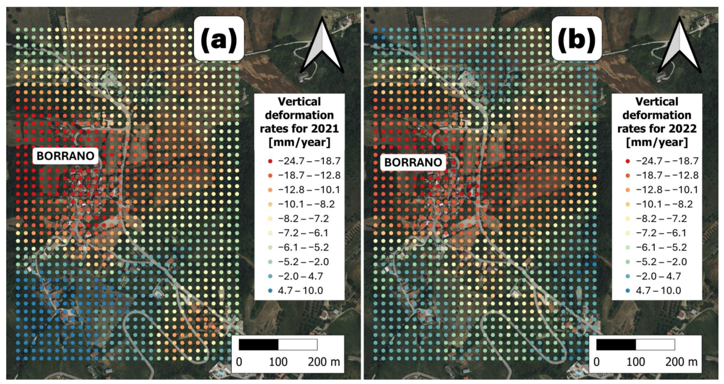
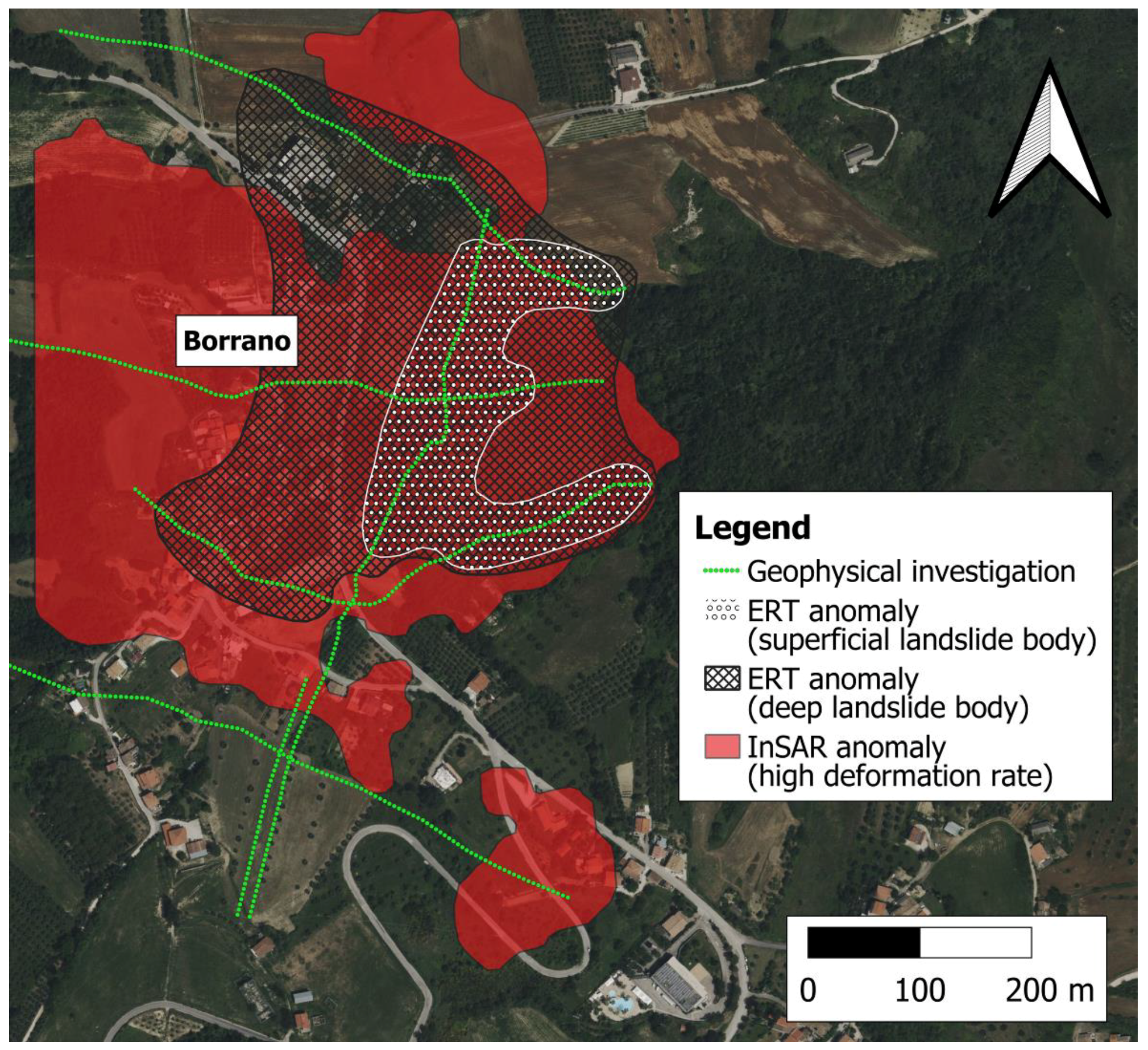
3.2. Evidence from the Interpretation of SRT, ERT, and SAR Data

The SRT results indicate very low P-wave velocities (Vp < 500 m/s) within approximately the upper 10 m of surficial deposits, outlining the spatial extent of the shallow slope instability phenomena. These deposits, characterized by low P-wave velocities, could correspond to the cover deposits with a predominantly sandy-clay matrix, which, according to borehole data, exhibited thicknesses ranging between approximately 4 and 13 m. These low velocities are likely associated with a high degree of weathering, de-structuring, and low material density. Despite these features, the Vp values show a gradual increase with depth, yet they fail to provide a clear distinction between the different lithological units present at the site (Figure 5). Moreover, the SRT findings struggle to delineate deep landslide bodies within the challenging geological context.
The ERT interpretation identifies resistivity contrasts primarily driven by the lithological nature of the subsurface and slope denudation processes. The inverted ERT sections spatially depict both shallow and deep landslide bodies and potentially suggest the location of sliding surfaces based on evident resistivity contrasts. Nearly all resistivity profiles show localized surface-cover anomalies characterized by moderately resistive values (>20 Ohm·m) and thicknesses ranging from 4.0 to 10.0 m. These anomalies could be linked to the presence of superficial landslide bodies, which are more aerated compared to the surrounding and underlying materials and are coherently delineated by the SRT. Additionally, several ERT profiles reveal deeper anomalies with a more conductive behavior that are not detected by the SRT. Such evidence, characterized by a lower resistivity fingerprint (<11 Ohm·m), extends to variable depths of approximately 50–100 m, and can likely be linked with large-scale mass movements involving fine-grained materials. Finally, the 2D resistivity profiles locally distinguish the arenaceous and clayey facies of the Teramo Flysch in areas unaffected by instability phenomena. The arenaceous facies exhibit a slightly more resistive electrical behavior (resistivity > 20 Ohm·m) compared to the clayey facies, which have a resistivity of less than approximately 10 Ohm·m (Figure 6).
The interpretation of the geophysical findings is validated by observations from the geological boreholes in Figure 1d, which indicate the transition from clayey to an arenaceous facies of the Teramo Flysch at depths between 41 and 55 m. This zone likely corresponds to planes of weakness between arenaceous and pelitic materials and potential deep sliding surfaces, detectable as resistivity contrasts observed in the ERT profiles outlined in Figure 6. The lithological boundary between two stratigraphic units, as identified in the borehole logs, is reflected in the resistivity contrasts, and constrains the delineation of failure planes at the interface at 11 Ohm·m within this geologically complex setting that exhibits only subtle variations in resistivity. Furthermore, Section 4–4’ in Figure 6 illustrates an ERT profile that may intersect one of the potential rupture lines indicated in Figure 4a. The processing of 3D-inverted geoelectrical data enabled the visualization of resistivity anomalies in a georeferenced space (Figure 7a), the delineation of the potential deep landslide body using an 11 Ohm·m resistivity isosurface (Figure 7b), and the estimation of its volume, which corresponds to approximately 7 million m3.
Additionally, the overall observation of horizontal slices at different elevations (Figure 8) extrapolated from the ERT sections spatially discriminates two macro-domains with different electrical behaviors.
Although the slices result from a plan-view interpolation process, the resistivity data acquired along the various arrays with an investigation resolution of 10 m pave the way for potentially refining large-scale field mapping. In the northeast portion of the area, almost exclusively conductive materials belonging to the clayey facies of the Teramo Flysch are present, while in the southwest domain, resistive materials associated with the arenaceous facies of the Teramo Flysch dominate. In this latter sector, resistive levels gradually deepen toward the E-NE direction, alternating locally with the conductive levels of the clayey facies according to the same bedding orientation in the geological sequence. The conceptualization of the electrical behavior of the subsurface helped in imaging the structural setting of the “dip-slope” substrate, refined the geological section constructed from field surveys through the integration of geoelectric data (Figure 9), and provides a data-driven picture of the predisposing factors for large-scale mass movements on-site.
The InSAR data analysis reveals negative vertical displacement rates for the urbanized areas of the village of Borrano, indicating ground downward movement and a retreat from the sensor. These rates range between approximately −10 and −24 mm/year for the years 2021 and 2022 (Figure 10).
SAR analysis quantifies the vertical displacement component of the roto-translational motion, parametrizing the deformation rates induced by the landslide. This downward motion is consistent with the behavior of a slope affected by gravitational instability, corroborating evidence from geophysical investigations. The observed deformation rates highlight the ongoing slow yet persistent activity, which is likely influenced by the interplay of lithological heterogeneity, structural settings, and external triggers such as precipitation or seismic events. The integration of InSAR data with geophysical interpretations provides a comprehensive understanding of the dynamic processes governing the area. Figure 11 illustrates the distribution and areal extent of shallow and deep landslide bodies, derived from the spatial-clustering ERT anomalies. Shallow and deep landslides associated with ERT anomalies extend over 37.5 km2 and 134.7 km2, respectively. These elements are integrated with, and spatially overlapped onto, regions exhibiting high deformation rates (greater than 10 mm/year), as inferred from SAR observations over the monitoring period.
This integrated visualization reveals a strong correspondence between ERT anomalies—both shallow and deep—and areas undergoing significant vertical displacement (Figure 11). Seismic data alone, which are indeed limited to a single profile, do not allow for a comprehensive delineation of the landslide-affected area. Consequently, the SRT anomaly—potentially depicting the shallow landslide body—is not represented in the map of Figure 11. Although the seismic survey at the start of the A–A’ ERT profile identified low P-wave velocities (<500 m/s) in the surficial landslide materials, these deposits exhibit moderately high resistivity values (>20 Ohm·m) due to their aerated, fractured nature and reduced moisture content—conditions that contribute to higher resistivity responses despite the low seismic velocities—highlighting the complex interplay of geophysical responses in these shallow slope instabilities.
The synthesis of geophysical and remote sensing findings provides a spatially resolved depiction of the anatomy of large-volume and complex landslides, while also allowing for an assessment of the sensitivity of different techniques in detecting slope instability phenomena.
The integrated assessment of SAR and ERT data offers a comprehensive framework for quantifying deformation rates and imaging the internal architecture of unstable slopes. When contextualized within the geological setting, these datasets support the development of a coherent hypothesis on the origin of the detected ground displacements. The deformation patterns are indicative of deep-seated gravitational slope deformations occurring along planes of weakness at the interface between arenaceous and pelitic units. Although not definitive, this hypothesis is strongly corroborated by the converging evidence from both InSAR and ERT analyses. SAR-derived displacement fields reveal zones of active ground motion, while resistivity anomalies detected through ERT delineate key subsurface discontinuities that likely govern landslide dynamics. The synergy of these independent datasets significantly enhances the interpretation of failure mechanisms for slope instability processes.
While nearly all geophysically defined bodies show InSAR anomalies, these anomalies sometimes extend over areas not covered by ERT and SRT anomalies. This misfit suggests significant spatial and temporal complexity and heterogeneity in the deformation processes, highlighting the need for more extensive borehole data coverage and higher-resolution geophysical surveys to capture the full extent and dynamics of instability within the complex geological architecture. Furthermore, our analysis raises some doubts about the effectiveness of SRT in imaging shallow and deep landslides in this stratigraphic context. It also highlights the importance of extending the satellite observation time interval to establish long-term landslide activity, and expanding the spatial coverage of InSAR analysis to encompass both the landslide and its surrounding areas.

4. Discussion

The geological context of the Borrano area, dominated by the Teramo Flysch formations, plays a critical role in predisposing the slopes to large-volume landslides. The alternation of resistant sandstone layers with weaker clayey marls creates a natural structural vulnerability, particularly where high structural dips and weak contact zones between facies are present [4,8,15,50]. This geological configuration is known to facilitate slow-moving, deep-seated landslides, even in cases where surface deformation may not be immediately apparent [8]. In our study, detailed geological surveys highlighted these structural predispositions, supporting previous findings that emphasize the necessity of geological investigations in landslide-prone, clay-rich environments [14,20,21,22,35].
Nevertheless, geological surveys alone were insufficient to fully map the complexity of the landslide bodies. Therefore, geophysical techniques were integrated to improve subsurface characterization. SRT captured shallow instability phenomena within the first 10 m, revealing limitations commonly reported in the literature [43,57]. Specifically, velocity inversion phenomena hindered deeper imaging, confirming that SRT alone may not resolve complex subsurface structures, especially in heterogeneous geological contexts with low-contrast interfaces [31,33,43,44,45]. Despite these limitations, SRT remains valuable for delineating near-surface weathered zones and landslide boundaries [24], and its combination with other methods is recommended to enhance interpretation [22,38,42,43].
The ERT surveys provided crucial insights into the deeper structure of the landslide bodies. The interpretation of potential sliding surfaces in this study primarily relied on the spatial distribution of resistivity contrasts identified by ERT, particularly the interface at approximately 11 Ohm·m. However, as highlighted by the geological cross-section (Figure 3b), this interface corresponds to the lithological boundary between the arenaceous and pelitic facies of the Teramo Flysch. Such a boundary, although mechanically weak and steeply inclined (~45°), is consistent with regional stratigraphy, and may not represent the classical shear surface typically associated with large-scale landslides, which is generally characterized by lower-angle geometries.
This distinction is crucial: while the ERT anomalies coincide with the lithological boundary and reflect contrasts in material competence and moisture content, they may not unequivocally denote active failure planes. Instead, they likely mark zones of mechanical susceptibility within the slope, where the combination of lithological heterogeneity and structural predisposition promotes deep-seated gravitational deformations (DSGSDs) in a dip-slope setting. This nuanced interpretation reconciles the ERT findings with the broader geological and geomechanical framework of the area. In Borrano, ERT effectively identified key resistivity contrasts corresponding to the contact zones between arenaceous and clayey facies, delineating the main sliding surfaces at depths consistent with inclinometric measurements (42–51 m) [50]. These findings align with previous studies that demonstrated the ability of ERT to map landslide geometry, identify sliding surfaces, and estimate material thickness in complex settings [7,20,21,35,58]. The acquisition setup, characterized by long profiles (>995 m) and wide electrode spacing (5–10 m), allowed for deep imaging (~200 m penetration depth) while accepting some trade-offs in resolution [15,16]. As noted by other authors [21,59,60,61,62], interpretation challenges persist in clay-rich, saturated subsoils where resistivity contrasts may be weak. However, at a large scale, ERT successfully delineates slope geometry and highlights critical weak zones, particularly when calibrated with borehole data [16,41].
In addition to geophysical surveys, remote sensing via InSAR analysis provided a spatially extensive view of surface displacements, detecting slow-moving landslides with displacement rates of around 10–15 mm/year—values comparable to those reported in the literature for similar phenomena [27]. Consistent with previous observations [5,9,30,48,63], InSAR proved particularly effective for long-term deformation monitoring. Although the InSAR data analyzed in this study span two years and offer valuable insights into the localized deformation rates, the lack of longer-term InSAR observations limits the ability to fully characterize the temporal evolution of slope instability. Recent photo-interpretation studies and in situ monitoring data, however, provide additional lines of evidence that support the progressive and long-term evolution of the Borrano landslide. Specifically, photogrammetric analyses of historical images (1981–1987) and more recent datasets (2010) reveal a marked expansion of the unstable area [50]. This trend is further corroborated by the surface monitoring data, including crack meter and inclinometer measurements, which display a continuous increase in displacement over time. Notably, the most significant vertical displacements recorded by the inclinometers occur between depths of 42.4 m and 51.4 m, corresponding to the interpreted deep slip surfaces. While the InSAR data alone cannot provide a complete history of landslide activity, the convergence of evidence from these complementary datasets indicates ongoing and progressive deformation in the Borrano area, consistent with the hypothesis of active deep-seated gravitational slope deformations within this geologically complex setting.
In our study, SAR-derived displacement patterns corresponded with zones identified as unstable in geological and geophysical data, reinforcing the integrated interpretation approach.
The synergy between ERT, SRT, InSAR, and geological data allowed for a comprehensive multi-scale assessment of landslide behavior in Borrano. ERT’s identification of curvilinear sliding surfaces matched vertical displacements detected by SAR monitoring, mirroring patterns documented in other case studies, such as Hollin Hill (UK) [39,64], the northwest Himalayas [65], and Ciudad Victoria (Ecuador) [66]. In all these contexts, integrating DInSAR with ERT enhanced the understanding of landslide mechanisms: SAR captured displacement trends and activity zones, while ERT refined subsurface interpretations by pinpointing failure planes and internal deformation structures [5,25,38,39,41,64].
Ultimately, our results confirm that vertical displacements observed via remote sensing are expressions of deeper structural deformations in roto-translational landslides. The combined use of geological, geophysical, and remote sensing data provides a complete and more accurate framework for characterizing slope instability and informing hazard mitigation strategies, in line with observations from numerous studies [25,38,39,41,49]. Nevertheless, each method has inherent limitations, underscoring the importance of a multidisciplinary approach to reduce interpretative uncertainties [60,61,62].

5. Conclusions

5.1. Key Findings

This study highlights the complex interplay between geological structures and slope geometry in driving landslide dynamics in the Borrano area. The integration of geological surveys, geophysical investigations (ERT, SRT), and remote sensing (InSAR) provided a comprehensive characterization of subsurface conditions and surface deformations.
SRT results identified shallow instability zones within the upper ~10 m, characterized by very low P-wave velocities (<500 m/s), consistent with highly weathered, de-structured, and low-density cover deposits. Borehole data indicated that these materials have thicknesses ranging from 4 to 13 m, suggesting widespread shallow instability, despite the velocity increase with depth preventing a clear separation of lithological units. ERT surveys revealed significant resistivity contrasts linked to both lithological variability and denudation processes. Shallow anomalies (moderately resistive, >20 Ohm·m; thicknesses of 4–10 m) correspond to superficial landslide bodies. In contrast, deeper conductive zones (<11 Ohm·m), extending to depths of 50–100 m, indicate large-scale, deep-seated mass movements involving fine-grained materials. The 2D resistivity profiles distinguished between the arenaceous (>20 Ohm·m) and clayey (<10 Ohm·m) facies of the Teramo Flysch, corroborated by borehole transitions observed at depths of 41–55 m. The 3D inversion of resistivity data allowed for the georeferenced visualization of subsurface anomalies and the delineation of a deep landslide body using an 11 Ohm·m isosurface, estimating a displaced volume of approximately 7 million m3. Horizontal ERT slices identified two macro-domains: a conductive northeast sector dominated by clayey flysch, and a resistive southwest sector characterized by arenaceous layers deepening towards the east–northeast direction. InSAR data confirmed continuous deformation, with vertical displacement rates ranging from −10 to −24 mm/year, underscoring the persistent activity of slope processes in the area.

5.2. Methodological Contributions and Technical Implications

The findings emphasize the importance of a multi-method approach in landslide assessment and hazard evaluation. ERT and InSAR data emerged as the key drivers of the integrated analysis, providing a robust framework for characterizing the geophysical structure of unstable slopes, delineating subsurface discontinuities, identifying potential sliding surfaces, and quantifying deformation rates.
SRT data, geological information, and borehole logs served as complementary sources, supporting and refining the interpretation by integrating different scales and physical-property contrasts. When combined with the geological context, these multi-source datasets enabled the formulation of a hypothesis regarding the origin of the detected displacement processes, with each technique compensating for the limitations of the others.

Author Contributions

Conceptualization, P.C., M.M. and L.M.G.; methodology, M.M. and L.M.G.; software, B.B.; validation, N.S., C.E. and G.S.; formal analysis, M.M. and L.M.G.; investigation, B.B. and M.M.; resources, N.S.; data curation, M.M., L.M.G. and B.B.; writing—original draft preparation, P.C.; writing—review and editing, L.M.G.; visualization, C.E.; supervision, N.S. and G.S.; project administration, N.S. All authors have read and agreed to the published version of the manuscript.

Funding

This research received no external funding.

Data Availability Statement

The raw data supporting the conclusions of this article will be made available by the authors on request.

Conflicts of Interest

Author Benedetto Burchini was employed by the company Trigeo s.n.c.. The remaining authors declare that the research was conducted in the absence of any commercial or financial relationships that could be construed as a potential conflict of interest.

References

  1. Hungr, O.; Leroueil, S.; Picarelli, L. The Varnes classification of landslide types, an update. Landslides 2014, 11, 167–194. [Google Scholar] [CrossRef]
  2. Reichenbach, P.; Rossi, M.; Malamud, B.D.; Mihir, M.; Guzzetti, F. A review of statistically-based landslide susceptibility models. Earth-Sci. Rev. 2018, 180, 60–91. [Google Scholar] [CrossRef]
  3. Ao, M.; Wei, L.; Liao, M.; Zhang, L.; Dong, J.; Liu, S. Incremental multi temporal InSAR analysis via recursive sequential estimator for long-term landslide deformation monitoring. ISPRS J. Photogramm. Remote Sens. 2024, 215, 313–330. [Google Scholar] [CrossRef]
  4. Auflič, M.J.; Herrera, G.; Mateos, R.M.; Poyiadji, E.; Quental, L.; Severine, B.; Peternel, T.; Podolszki, L.; Calcaterra, S.; Kociu, A.; et al. Landslide Monitoring Techniques in the Geological Surveys of Europe. Landslides 2023, 20, 951–965. [Google Scholar] [CrossRef]
  5. Bentivenga, M.; Bellanova, J.; Calamita, G.; Capece, A.; Cavalcante, F.; Gueguen, E.; Guglielmi, P.; Murgante, B.; Palladino, G.; Perrone, A.; et al. Geomorphological and Geophysical Surveys with InSAR Analysis Applied to the Picerno Earth Flow (Southern Apennines, Italy). Landslides 2021, 18, 471–483. [Google Scholar] [CrossRef]
  6. Boyd, J.; Chambers, J.; Wilkinson, P.; Peppa, M.; Watlet, A.; Kirkham, M.; Jones, L.; Swift, R.; Meldrum, P.; Uhlemann, S.; et al. A linked geomorphological and geophysical modelling methodology applied to an active landslide. Landslides 2021, 18, 2689–2704. [Google Scholar] [CrossRef]
  7. Cassiani, G.; Godio, A.; Stocco, S.; Villa, A.; Deiana, R.; Frattini, P.; Rossi, M. Monitoring the hydrologic behaviour of a mountain slope via time-lapse electrical resistivity tomography. Near Surf. Geophys. 2009, 7, 475–486. [Google Scholar] [CrossRef]
  8. Gutiérrez, F.; Linares, R.; Roqué, C.; Zarroca, M.; Carbonel, D.; Rosell, J.; Gutiérrez, M. Large landslides associated with a diapiric fold in Canelles Reservoir (Spanish Pyrenees): Detailed geological–geomorphological mapping, trenching and electrical resistivity imaging. Geomorphology 2015, 241, 224–242. [Google Scholar] [CrossRef]
  9. Yang, D.; Qiu, H.; Zhu, Y.; Liu, Z.; Pei, Y.; Ma, S.; Du, C.; Sun, H.; Liu, Y.; Cao, M. Landslide Characteristics and Evolution: What We Can Learn from Three Adjacent Landslides. Remote Sens. 2021, 13, 4579. [Google Scholar] [CrossRef]
  10. Aringoli, D.; Farabollini, P.; Pambianchi, G.; Materazzi, M.; Bufalini, M.; Fuffa, E.; Gentilucci, M.; Scalella, G. Geomorphological hazard in active tectonics area: Study cases from Sibillini Mountains thrust system (Central Apennines). Land 2021, 10, 510. [Google Scholar] [CrossRef]
  11. Della Seta, M.; Esposito, C.; Marmoni, G.M.; Martino, S.; Scarascia Mugnozza, G.; Troiani, F. Morpho–structural evolution of the valley—Slope systems and related implications on slope–scale gravitational processes: New results from the Mt. Genzana case history (Central Apennines, Italy). Geomorphology 2017, 289, 60–77. [Google Scholar] [CrossRef]
  12. Mangifesta, M.; Aringoli, D.; Pambianchi, G.; Giannini, L.M.; Scalella, G.; Sciarra, N. A Methodologic Approach to Study Large and Complex Landslides: An Application in Central Apennines. Geosciences 2024, 14, 272. [Google Scholar] [CrossRef]
  13. Santangelo, M.; Marchesini, I.; Bucci, F.; Cardinali, M.; Cavalli, M.; Crema, S.; Marchi, L.; Alvioli, M.; Guzzetti, F. Exposure to landslides in rural areas in Central Italy. J. Maps 2021, 17, 124–132. [Google Scholar] [CrossRef]
  14. Břežný, M.; Pánek, T. Deep-seated landslides affecting monoclinal flysch morphostructure: Evaluation of LiDAR-derived topography of the highest range of the Czech Carpathians. Geomorphology 2017, 285, 44–57. [Google Scholar] [CrossRef]
  15. Chalupa, V.; Pánek, T.; Břežný, M.; Gutiérrez, F.; Medialdea, A. Evolution of deep-seated gravitational slope deformation in a deep valley of the Czech Flysch Carpathians. Geomorphology 2025, 470, 109545. [Google Scholar] [CrossRef]
  16. Merritt, A.; Chambers, J.; Murphy, W.; Wilkinson, P.; West, L.; Gunn, D.; Meldrum, P.; Kirkham, M.; Dixon, N. 3D ground model development for an active landslide in Lias mudrocks using geophysical, remote sensing and geotechnical methods. Landslides 2014, 11, 537–550. [Google Scholar] [CrossRef]
  17. Bièvre, G.; Jongmans, D.; Goutaland, D.; Pathier, E.; Zumbo, V. Geophysical characterization of the lithological control on the kinematic pattern in a large clayey landslide (Avignonet, French Alps). Landslides 2016, 13, 423–436. [Google Scholar] [CrossRef]
  18. Hu, S.; Wang, X.; Wang, N.; Yang, D.; Wang, D.; Ma, S.; Song, Z.; Cao, M. Dynamic process, influence, and triggering mechanism of slope remodelling by landslide clusters in the South Jingyang Tableland, China. CATENA 2022, 217, 106518. [Google Scholar] [CrossRef]
  19. Kasprzak, M.; Jancewicz, K.; Różycka, M.; Kotwicka, W.; Migoń, P. Geomorphology-and geophysics-based recognition of stages of deep-seated slope deformation (Sudetes, SW Poland). Eng. Geol. 2019, 260, 105230. [Google Scholar] [CrossRef]
  20. Bellanova, J.; Calamita, G.; Giocoli, A.; Luongo, R.; Macchiato, M.; Perrone, A.; Uhlemann, S.; Piscitelli, S. Electrical resistivity imaging for the characterization of the Montaguto landslide (southern Italy). Eng. Geol. 2018, 243, 272–281. [Google Scholar] [CrossRef]
  21. Perrone, A.; Lapenna, V.; Piscitelli, S. Electrical resistivity tomography technique for landslide investigation: A review. Earth-Sci. Rev. 2014, 135, 65–82. [Google Scholar] [CrossRef]
  22. Soto, J.; Galve, J.P.; Palenzuela, J.A.; Azañón, J.M.; Tamay, J.; Irigaray, C. A Multi-Method Approach for the Characterization of Landslides in an Intramontane Basin in the Andes (Loja, Ecuador). Landslides 2017, 14, 1929–1947. [Google Scholar] [CrossRef]
  23. Li, R.; Hu, X.; Xu, D.; Liu, Y.; Yu, N. Characterizing the 3D hydrogeological structure of a debris landslide using the transient electromagnetic method. J. Appl. Geophys. 2020, 175, 103991. [Google Scholar] [CrossRef]
  24. Uhlemann, S.; Hagedorn, S.; Dashwood, B.; Maurer, H.; Gunn, D.; Dijkstra, T.; Chambers, J. Landslide characterization using P-and S-wave seismic refraction tomography—The importance of elastic moduli. J. Appl. Geophys. 2016, 134, 64–76. [Google Scholar] [CrossRef]
  25. Aguzzoli, A.; Arosio, D.; Mulas, M.; Ciccarese, G.; Bayer, B.; Winkler, G.; Ronchetti, F. Multidisciplinary non-invasive investigations to develop a hydrogeological conceptual model supporting slope kinematics at Fontana Cornia landslide, Northern Apennines, Italy. Environ. Earth Sci. 2022, 81, 471. [Google Scholar] [CrossRef]
  26. Podolszki, L.; Kosović, I.; Novosel, T.; Kurečić, T. Multi-Level Sensing Technologies in Landslide Research—Hrvatska Kostajnica Case Study, Croatia. Sensors 2022, 22, 177. [Google Scholar] [CrossRef]
  27. Bounab, A.; El Kharim, Y.; El Hamdouni, R.; Hlila, R. A multidisciplinary approach to study slope instability in the Alboran Sea shoreline: Study of the Tamegaret deep-seated slow-moving landslide in Northern Morocco. J. Afr. Earth Sci. 2021, 184, 104345. [Google Scholar] [CrossRef]
  28. Giannini, L.M.; Younsi, S.; Burchini, B.; Deiana, R.; Cassiani, G.; Ciampi, P. Integrating Geophysical Methods, InSAR, and Field Observations to Address Geological Hazards and Buried Archaeological Features in Urban Landscapes. J. Appl. Geophys. 2025, 238, 105726. [Google Scholar] [CrossRef]
  29. Kannaujiya, S.; Chattoraj, S.L.; Jayalath, D.; Champati Ray, P.K.; Bajaj, K.; Podali, S.; Bisht, M.P.S. Integration of satellite remote sensing and geophysical techniques (electrical resistivity tomography and ground penetrating radar) for landslide characterization at Kunjethi (Kalimath), Garhwal Himalaya, India. Nat. Hazards 2019, 97, 1191–1208. [Google Scholar] [CrossRef]
  30. Liu, X.; Zhao, C.; Zhang, Q.; Peng, J.; Zhu, W.; Lu, Z. Multi-Temporal Loess Landslide Inventory Mapping with C-, X- and L-Band SAR Datasets—A Case Study of Heifangtai Loess Landslides, China. Remote Sens. 2018, 10, 1756. [Google Scholar] [CrossRef]
  31. Himi, M.; Anton, M.; Sendrós, A.; Abancó, C.; Ercoli, M.; Lovera, R.; Deidda, G.P.; Urruela, A.; Rivero, L.; Casas, A. Application of Resistivity and Seismic Refraction Tomography for Landslide Stability Assessment in Vallcebre, Spanish Pyrenees. Remote Sens. 2022, 14, 6333. [Google Scholar] [CrossRef]
  32. Pastor, J.L.; Tomás, R.; Lettieri, L.; Riquelme, A.; Cano, M.; Infante, D.; Ramondini, M.; Di Martire, D. Multi-Source Data Integration to Investigate a Deep-Seated Landslide Affecting a Bridge. Remote Sens. 2019, 11, 1878. [Google Scholar] [CrossRef]
  33. Qi, S.; Zou, Y.; Wu, F.; Yan, C.; Fan, J.; Zang, M.; Zhang, S.; Wang, R. A Recognition and Geological Model of a Deep-Seated Ancient Landslide at a Reservoir under Construction. Remote Sens. 2017, 9, 383. [Google Scholar] [CrossRef]
  34. Sciarra, N.; Mangifesta, M.; Carabba, L.; Mischiatti, L. Methodological Approach for the Study of Historical Centres of High Architectural Value Affected by Geo-Hydrological Hazards: The Case of Lanciano (Abruzzo Region—Central Italy). Geosciences 2022, 12, 193. [Google Scholar] [CrossRef]
  35. Orozco, A.F.; Bücker, M.; Steiner, M.; Malet, J.P. Complex-conductivity imaging for the understanding of landslide architecture. Eng. Geol. 2018, 243, 241–252. [Google Scholar] [CrossRef]
  36. Pavoni, M.; Carrera, A.; Boaga, J. Improving the Galvanic Contact Resistance for Geoelectrical Measurements in Debris Areas: A Case Study. Near Surf. Geophys. 2022, 20, 178–191. [Google Scholar] [CrossRef]
  37. Ciampi, P.; Giannini, L.M.; Cassiani, G.; Esposito, C.; Petrangeli, P.M. Geo-constrained clustering of resistivity data revealing the heterogeneous lithological architectures and the distinctive geoelectrical signature of shallow deposits. Eng. Geol. 2024, 337, 107589. [Google Scholar] [CrossRef]
  38. Samodra, G.; Ramadhan, M.F.; Sartohadi, J.; Setiawan, M.A.; Christanto, N.; Sukmawijaya, A. Characterization of Displacement and Internal Structure of Landslides from Multitemporal UAV and ERT Imaging. Landslides 2020, 17, 2455–2468. [Google Scholar] [CrossRef]
  39. Xu, D.; Hu, X.Y.; Shan, C.L.; Li, R.H. Landslide monitoring in southwestern China via time-lapse electrical resistivity tomography. Appl. Geophys. 2016, 13, 1–2. [Google Scholar] [CrossRef]
  40. Sun, M.; Liu, J.; Ou, J.; Liu, R.; Zhu, L. Electrical Resistivity Tomography (ERT) Investigation for Landslides: Case Study in the Hunan Province, China. Appl. Sci. 2024, 14, 3007. [Google Scholar] [CrossRef]
  41. Huntley, D.; Bobrowsky, P.; Hendry, M.; Macciotta, R.; Best, M. Multi-technique geophysical investigation of a very slow-moving landslide near Ashcroft, British Columbia, Canada. J. Environ. Eng. Geophys. 2019, 24, 87–110. [Google Scholar] [CrossRef]
  42. Huayllazo, Y.; Infa, R.; Soto, J.; Lazarte, K.; Huanca, J.; Alvarez, Y.; Teixidó, T. Using Electrical Resistivity Tomography Method to Determine the Inner 3D Geometry and the Main Runoff Directions of the Large Active Landslide of Pie de Cuesta in the Vítor Valley (Peru). Geosciences 2023, 13, 342. [Google Scholar] [CrossRef]
  43. Imani, P.; El-Raouf, A.A.; Tian, G. Landslide investigation using Seismic Refraction Tomography method: A review. Ann. Geophys. 2022, 64, SE657. [Google Scholar] [CrossRef]
  44. Mreyen, A.S.; Cauchie, L.; Micu, M.; Onaca, A.; Havenith, H.B. Multiple geophysical investigations to characterize massive slope failure deposits: Application to the Balta rockslide, Carpathians. Geophys. J. Int. 2021, 225, 1032–1047. [Google Scholar] [CrossRef]
  45. Wróbel, M.; Stan-Kłeczek, I.; Marciniak, A.; Majdański, M.; Kowalczyk, S.; Nawrot, A.; Cader, J. Integrated Geophysical Imaging and Remote Sensing for Enhancing Geological Interpretation of Landslides with Uncertainty Estimation—A Case Study from Cisiec, Poland. Remote Sens. 2023, 15, 238. [Google Scholar] [CrossRef]
  46. Casagli, N.; Intrieri, E.; Tofani, V.; Gigli, G.; Raspini, F. Landslide detection, monitoring and prediction with remote-sensing techniques. Nat. Rev. Earth Environ. 2023, 4, 51–64. [Google Scholar] [CrossRef]
  47. Donati, D.; Stead, D.; Rabus, B.; Engelbrecht, J.; Clague, J.J.; Newman, S.D.; Francioni, M. Characterization of the Fels Landslide (Alaska) Using Combined Terrestrial, Aerial, and Satellite Remote Sensing Data. Remote Sens. 2024, 16, 117. [Google Scholar] [CrossRef]
  48. Bian, S.; Chen, G.; Zeng, R.; Meng, X.; Jin, J.; Lin, L.; Zhang, Y.; Shi, W. Post-failure evolution analysis of an irrigation-induced loess landslide using multiple remote sensing approaches integrated with time-lapse ERT imaging: Lessons from Heifangtai, China. Landslides 2022, 19, 1179–1197. [Google Scholar] [CrossRef]
  49. Perrone, A.; Zeni, G.; Piscitelli, S.; Pepe, A.; Loperte, A.; Lapenna, V.; Lanari, R. Joint analysis of SAR interferometry and electrical resistivity tomography surveys for investigating ground deformation: The case-study of Satriano di Lucania (Potenza, Italy). Eng. Geol. 2006, 88, 260–273. [Google Scholar] [CrossRef]
  50. Mangifesta, M.; Ciampi, P.; Giannini, L.M.; Esposito, C.; Scalella, G.; Sciarra, N. DsGSD numerical modelling supported by an integrated geognostic surveys: The case of the Borrano (Abruzzo Region—Central Italy). Geosciences 2025, 15, 134. [Google Scholar] [CrossRef]
  51. Il Portale dei Dati Aperti Della Regione Abruzzo. Available online: http://opendata.regione.abruzzo.it/ (accessed on 18 March 2025).
  52. Geoportale Nazionale MASE. Available online: https://gn.mase.gov.it/portale/home (accessed on 18 March 2025).
  53. ERTLab Studio. Available online: http://www.geostudiastier.it/area_en.asp?idCanale=56&sezione=1 (accessed on 18 March 2025).
  54. ASF Data Search. Available online: https://search.asf.alaska.edu/ (accessed on 18 March 2025).
  55. SNAP Download. Available online: https://step.esa.int/main/download/snap-download/ (accessed on 18 March 2025).
  56. STAMPS.com. Available online: https://www.stamps.com/download/ (accessed on 18 March 2025).
  57. Petronio, L.; Boaga, J.; Cassiani, G. Characterization of the vajont landslide (north-eastern italy) by means of reflection and surface wave seismics. J. Appl. Geophys. 2016, 128, 58–67. [Google Scholar] [CrossRef]
  58. Boyd, J.P.; Binley, A.; Wilkinson, P.; Holmes, J.; Bruce, E.; Chambers, J. Practical considerations for using petrophysics and geoelectrical methods on clay rich landslides. Eng. Geol. 2024, 334, 107506. [Google Scholar] [CrossRef]
  59. Loke, M.H.; Chambers, J.E.; Rucker, D.F.; Kuras, O.; Wilkinson, P.B. Recent developments in the direct-current geoelectrical imaging method. J. Appl. Geophys. 2013, 95, 135–156. [Google Scholar] [CrossRef]
  60. Nasta, P.; Boaga, J.; Deiana, R.; Cassiani, G.; Romano, N. Comparing ERT-and Scaling-Based Approaches to Parameterize Soil Hydraulic Properties for Spatially Distributed Model Applications. Adv. Water Res. 2019, 126, 155–167. [Google Scholar] [CrossRef]
  61. Holmes, J.; Chambers, J.; Wilkinson, P.; Meldrum, P.; Cimpoiaşu, M.; Boyd, J.; Huntley, D.; Williamson, P.; Gunn, D.; Dashwood, B.; et al. Application of petrophysical relationships to electrical resistivity models for assessing the stability of a landslide in British Columbia, Canada. Eng. Geol. 2022, 301, 106613. [Google Scholar] [CrossRef]
  62. Hübner, R.; Heller, K.; Günther, T.; Kleber, A. Monitoring Hillslope Moisture Dynamics with Surface ERT for Enhancing Spatial Significance of Hydrometric Point Measurements. Hydrol. Earth Syst. Sci. 2015, 19, 225–240. [Google Scholar] [CrossRef]
  63. Zito, C.; Mangifesta, M.; Francioni, M.; Guerriero, L.; Di Martire, D.; Calcaterra, D.; Sciarra, N. Cascading Landslide: Kinematic and Finite Element Method Analysis through Remote Sensing Techniques. Remote Sens. 2024, 16, 3423. [Google Scholar] [CrossRef]
  64. Kelevitz, K.; Novellino, A.; Watlet, A.; Boyd, J.; Whiteley, J.; Chambers, J.; Jordan, C.; Wright, T.; Hooper, A.; Biggs, J. Ground and Satellite-Based Methods of Measuring Deformation at a UK Landslide Observatory: Comparison and Integration. Remote Sens. 2022, 14, 2836. [Google Scholar] [CrossRef]
  65. Rathore, H.A.; Abrar, N.; Farooq, M.; Khan, M.Y.; Turab, S.A.; Saralioglu, E.; Noor, S.; Niaz, J. Geophysical and geotechnical characterization of Lower Sudhan Gali Landslide (LSGL), Bagh Azad Jammu & Kashmir. Geomat. Nat. Hazards Risk 2024, 15, 2383775. [Google Scholar] [CrossRef]
  66. Jaramillo, G.G.; Galve, J.P.; Ortiz, M.F.G.; Reyes-Carmona, C.; Luzuriaga, J.S.; Azañón, J.M. Multi-technique approaches to diagnose unstable ground: Origin of the structural damages in Ciudad Victoria (Loja, Ecuador) case-study. J. S. Am. Earth Sci. 2024, 146, 105106. [Google Scholar] [CrossRef]
Figure 1. The study area’s location in the Italian Peninsula (a). The localization of geological investigations in the area, with the drilled depths indicated (b). Map data: © Google Earth. The sequence of lithotypes encountered at the six geological boreholes (BH1–BH6) (c). An image of a core box, highlighting the distinction between the pelitic and arenaceous facies sampled in the boreholes (d).
Remotesensing 17 02029 g001
Figure 2. The localization of the ERT and SRT survey profiles in the study area. Map data: © Google Earth.
Remotesensing 17 02029 g002
Figure 3. A geological map of the study area, showing the geological trace in plan view, the uncertain fault line, and the location of the arenaceous and clayey facies of the Teramo Flysch, identified in outcrops and boreholes, respectively (a). A 2D geological section showing the distinction between the pelitic and arenaceous facies of the Teramo Flysch and the localization of the potential sliding surface (b). A field image showing an outcrop of the Teramo Flysch in predominantly arenaceous facies (c). The location of the outcrop shown in (c) is indicated in (a). Details of the Teramo Flysch in predominantly pelitic facies identified in a borehole at depths exceeding 30 m (d). The location of the borehole log sampling the pelitic Flysch shown in (d) is illustrated in (a). Ground fissures observed on the slope surface are indicative of ongoing superficial deformation in the area surrounding the village of Borrano (e). Ground fractures highlighting differential soil displacement and confirming active landslide processes in the village of Borrano (f). Structural damage observed in a building within the village of Borrano, attributed to active landslide movements. Visible cracks on the wall and pavement indicate significant deformation linked to the underlying slope instability (g). Visible structural damage to a building in Borrano, caused by slope movements associated with active landslide processes (h). For the location of the sites illustrated in (eh), refer to (a).
Remotesensing 17 02029 g003
Figure 4. Identification of potential rupture lines in the area (a). Calculation of slope steepness within the study area (b).
Remotesensing 17 02029 g004
Figure 5. A 2D SRT section, showing the Vp values of near-surface lithologic units and delineating the potential sliding surface of the shallow landslide body.
Remotesensing 17 02029 g005
Figure 6. Two-dimensional ERT profiles depicting both shallow and deep landslide bodies, revealing the potential location of sliding surfaces and locally distinguishing the arenaceous and clayey facies of the Teramo Flysch.
Remotesensing 17 02029 g006
Figure 7. (a) Three-dimensional views of the inverted resistivity profiles; (b) delineation of the deep landslide volume using an 11 Ohm·m resistivity isosurface.
Remotesensing 17 02029 g007
Figure 8. Horizontal slices representing the resistivity values resulting from inversion at different elevations. The transparent dots on the contour maps represent the electrodes arranged along the geoelectrical profiles.
Remotesensing 17 02029 g008
Figure 9. Comparison between the geological section derived from field surveys (a) and the geological section integrated with geoelectrical interpretation (b), delineating the localization of sliding surfaces.
Remotesensing 17 02029 g009
Figure 10. Vertical deformation rates for the year 2021 (a) and the year 2022 (b). Map data: © Google Earth.
Remotesensing 17 02029 g010
Figure 11. A map delineating areas affected by high vertical deformation rates, as inferred from SAR data, and illustrating the spatial extent and distribution of both superficial and deep-seated landslides, as derived from the interpretation of ERT anomalies. Map data: © Google Earth.
Remotesensing 17 02029 g011
Disclaimer/Publisher’s Note: The statements, opinions and data contained in all publications are solely those of the individual author(s) and contributor(s) and not of MDPI and/or the editor(s). MDPI and/or the editor(s) disclaim responsibility for any injury to people or property resulting from any ideas, methods, instructions or products referred to in the content.

