
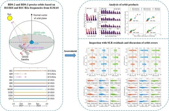
Comprehensive Assessment of BDS-2 and BDS-3 Precise Orbits Based on B1I/B3I and B1C/B2a Frequencies from iGMAS


Abstract
1. Introduction
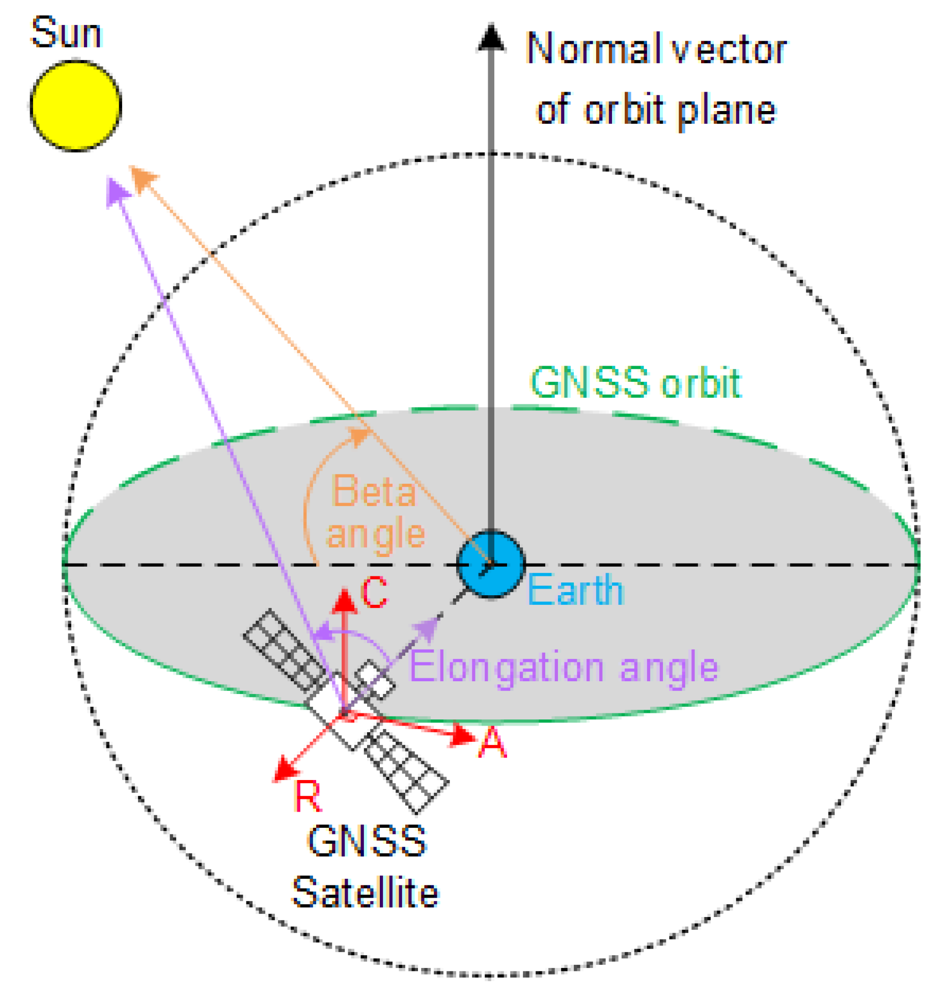
2. Methodology
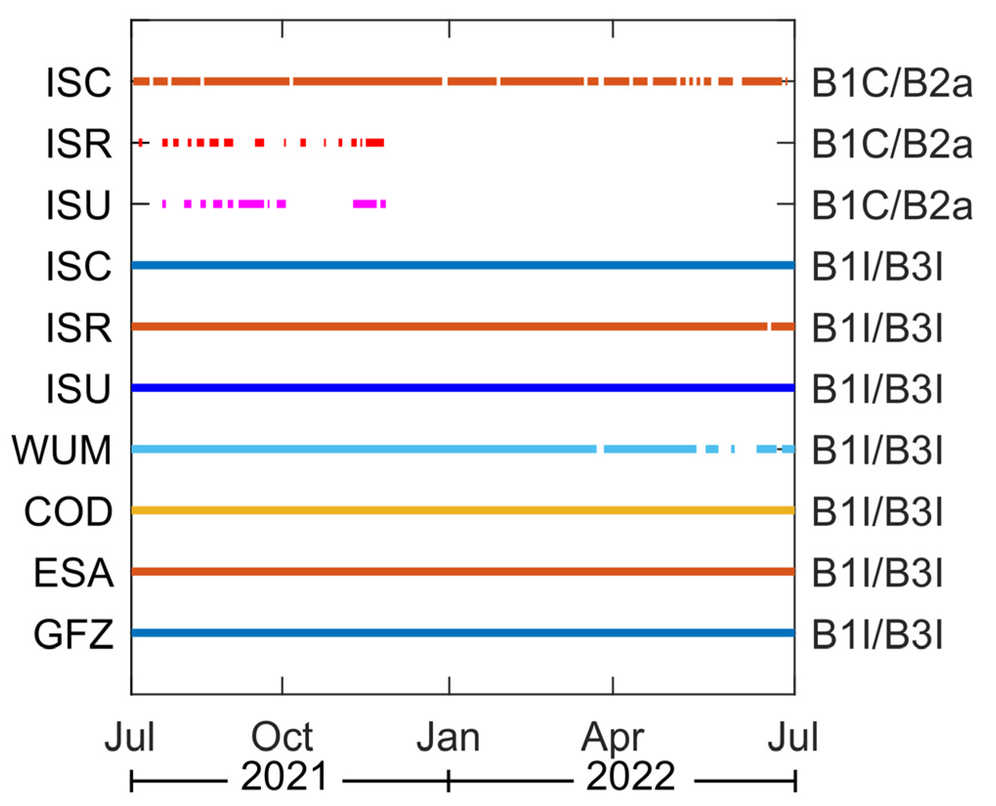
3. Data and Experiment
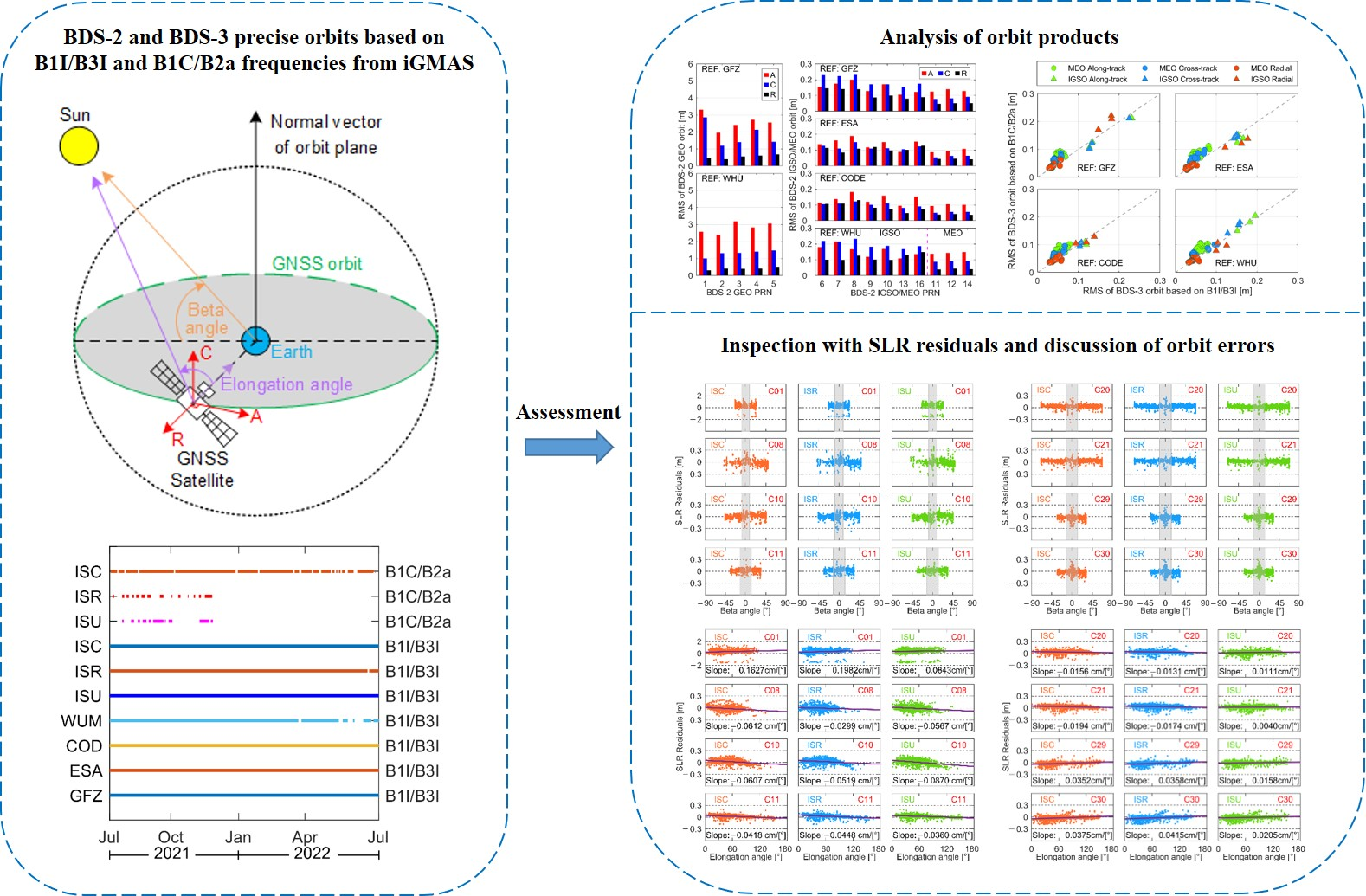
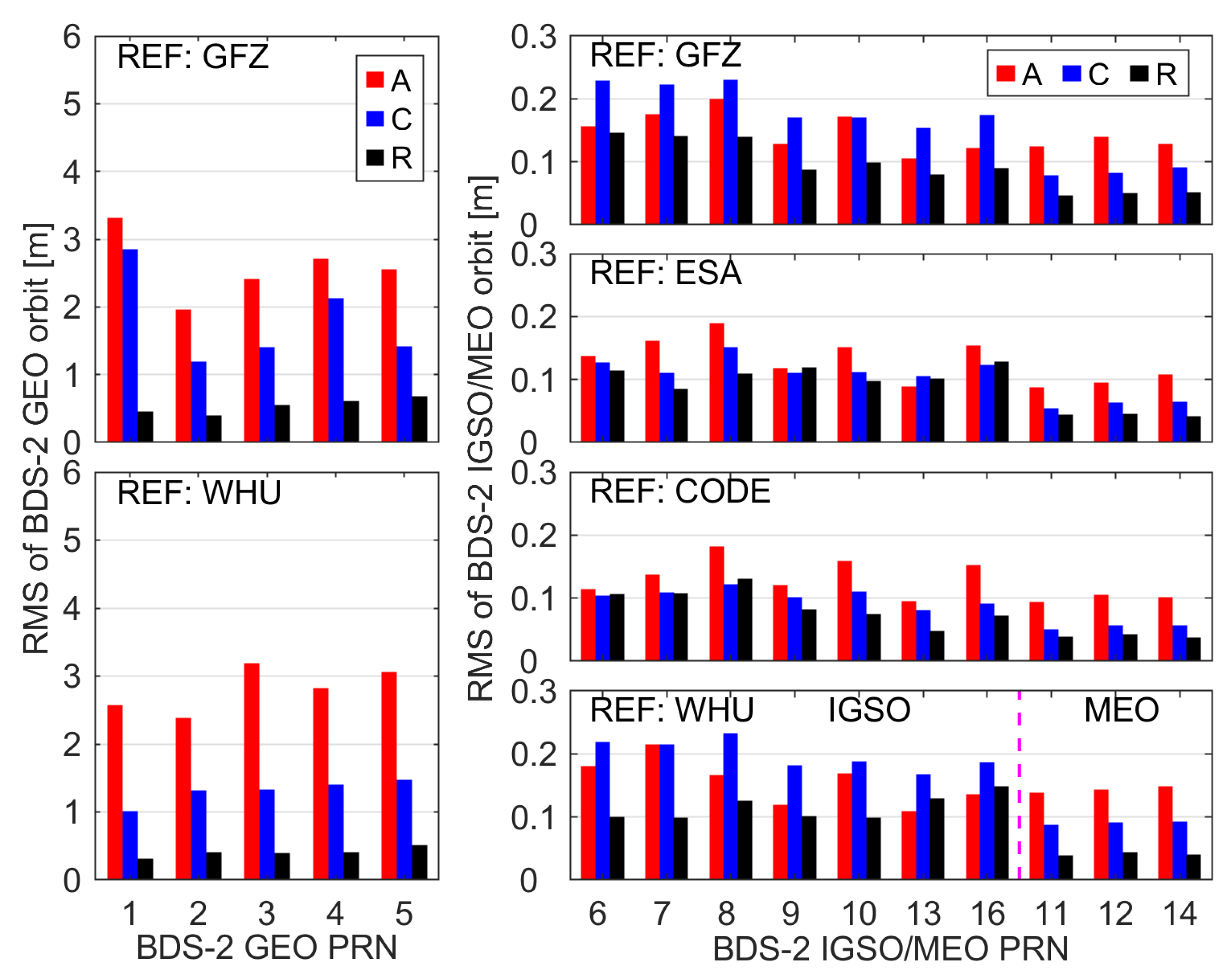
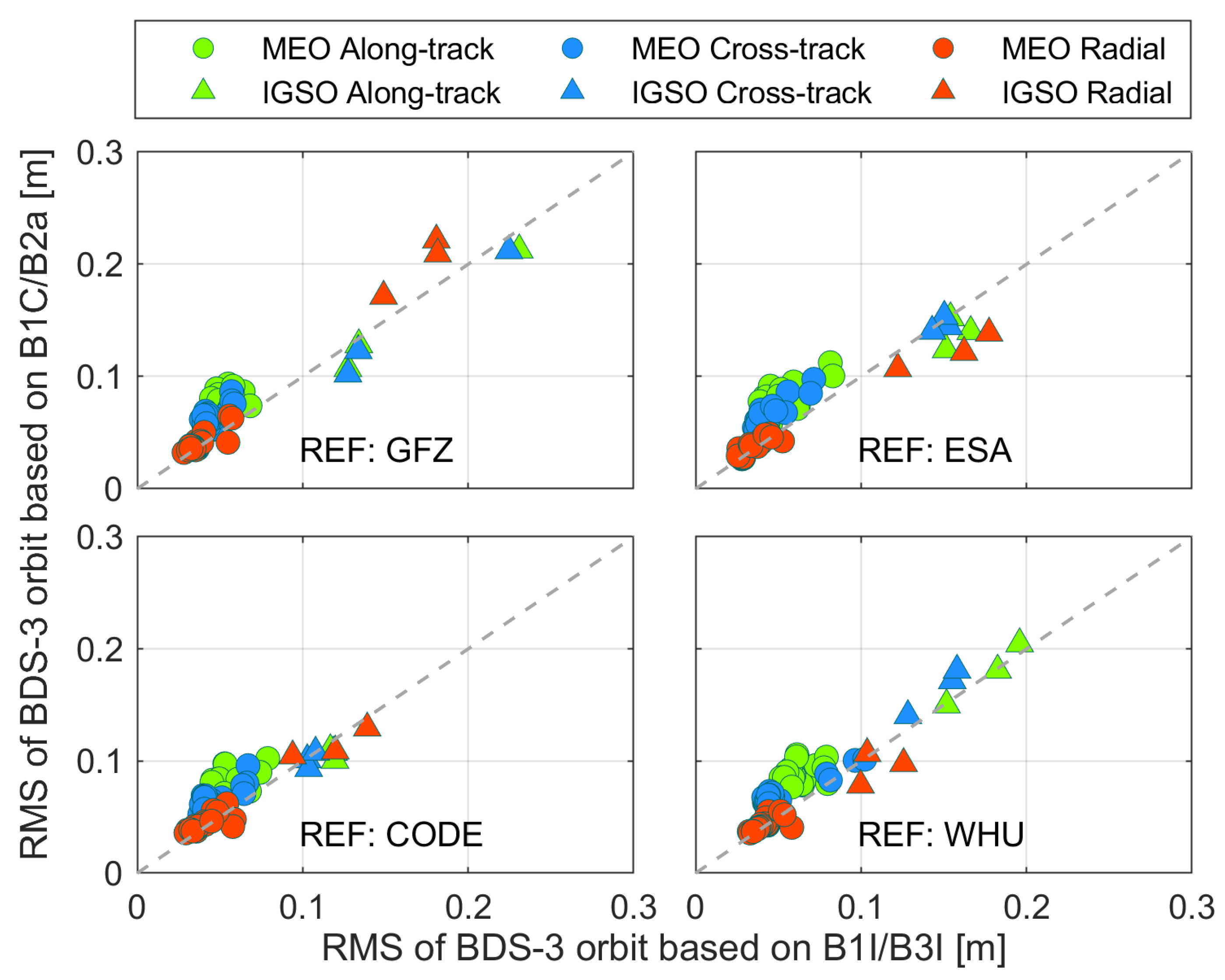
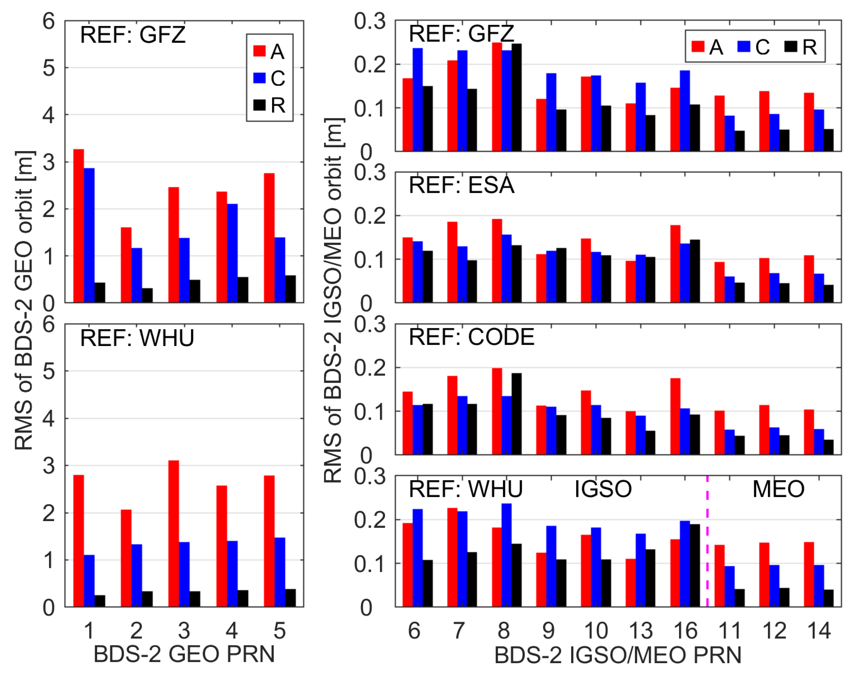
4. Analysis of Orbit Products
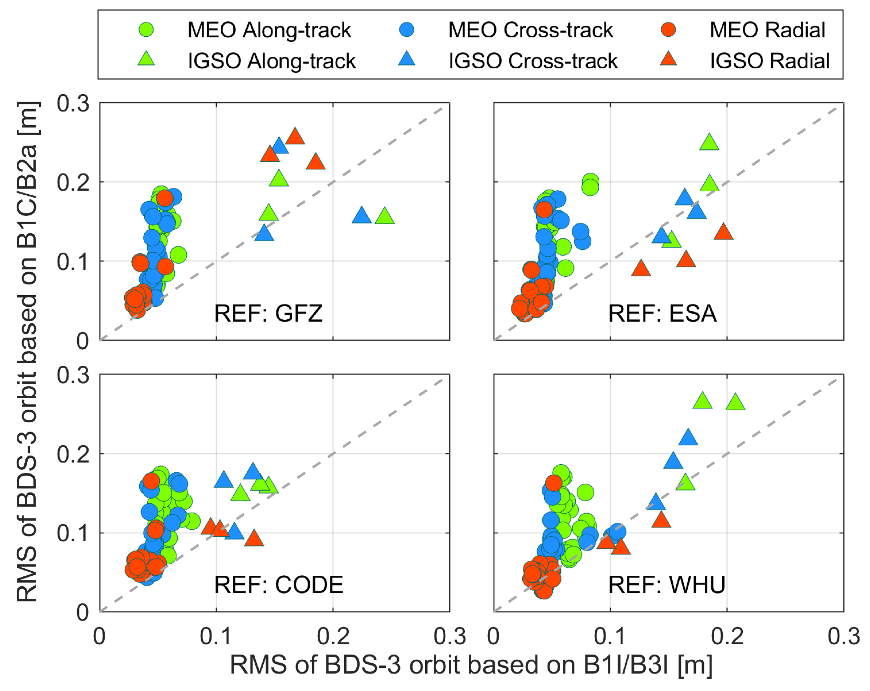
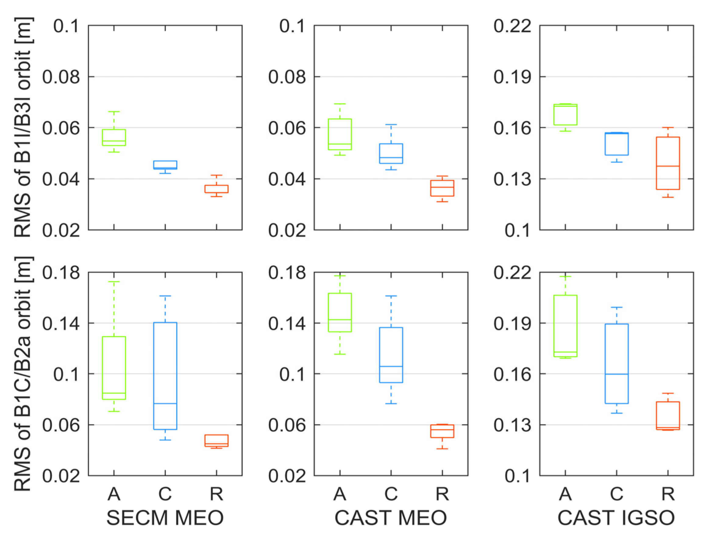
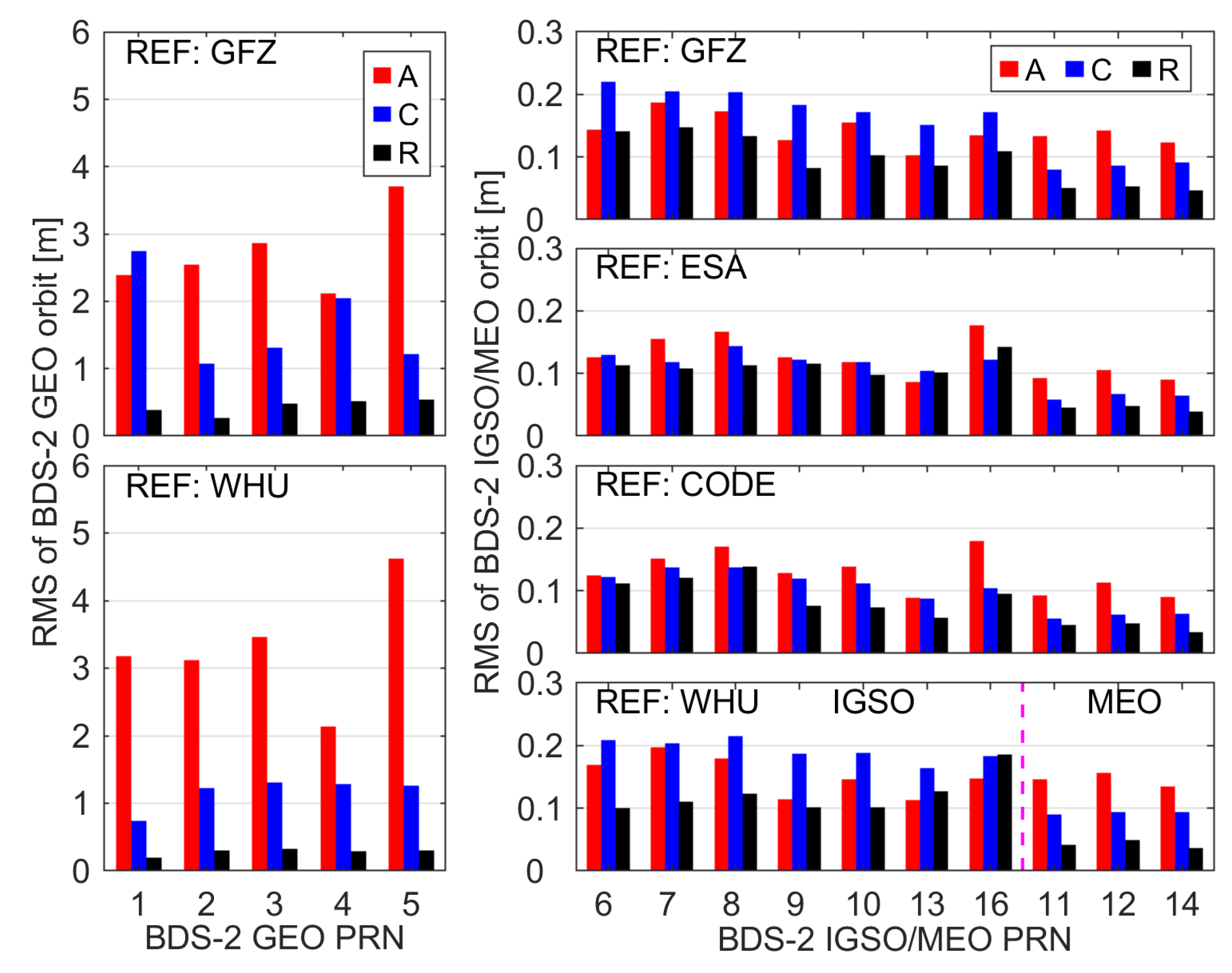
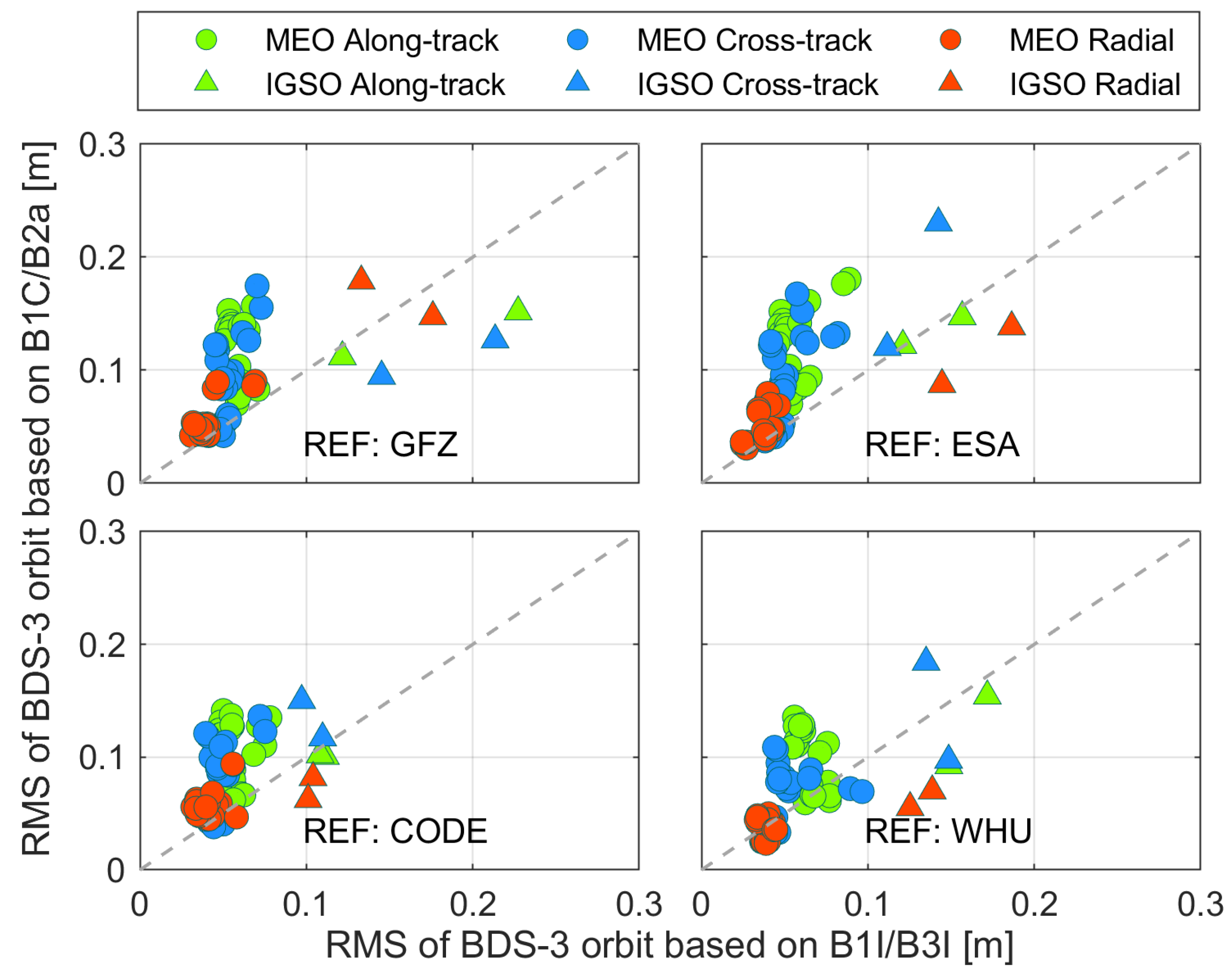
4.1. ISC Products
4.2. ISR Products
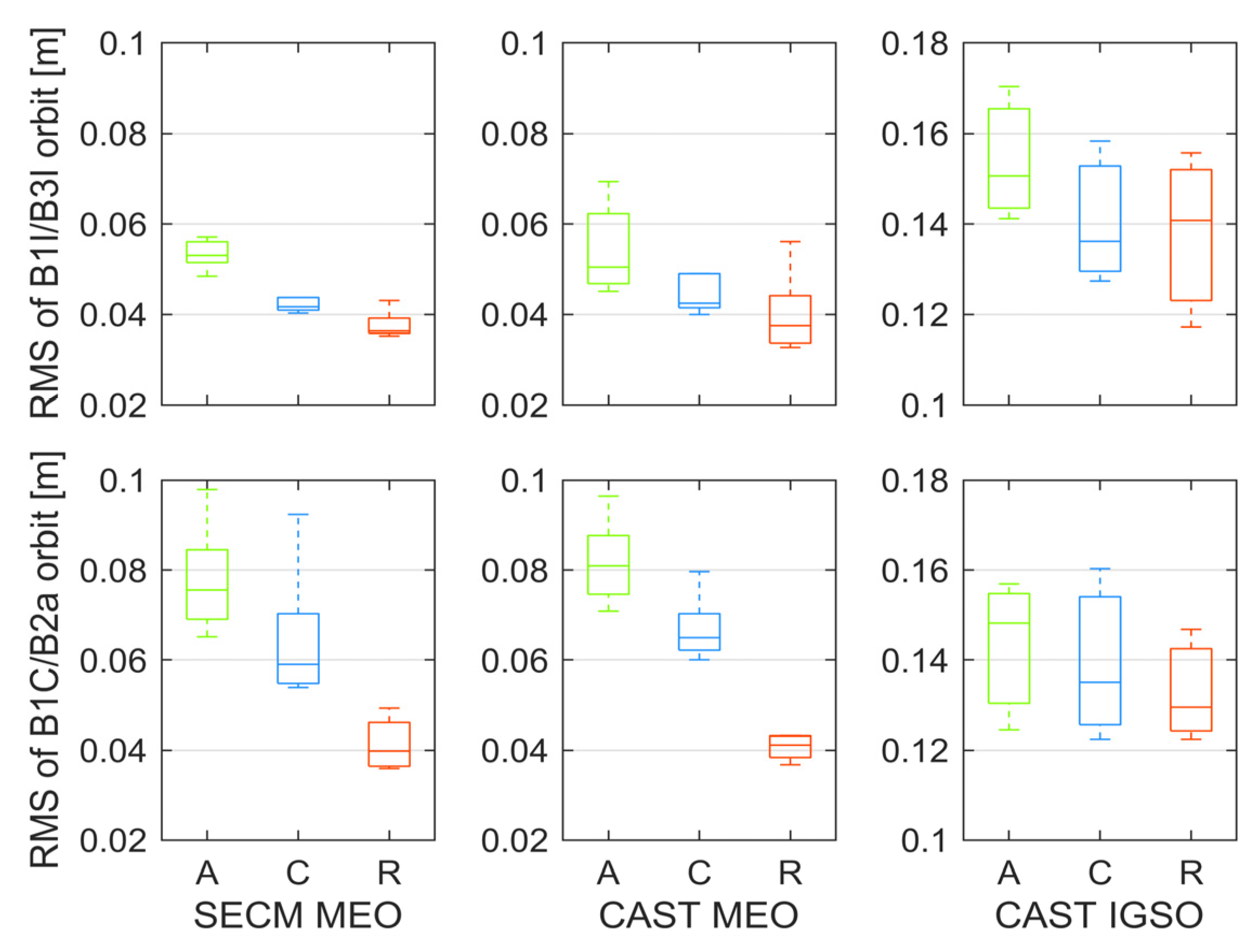
4.3. ISU Products
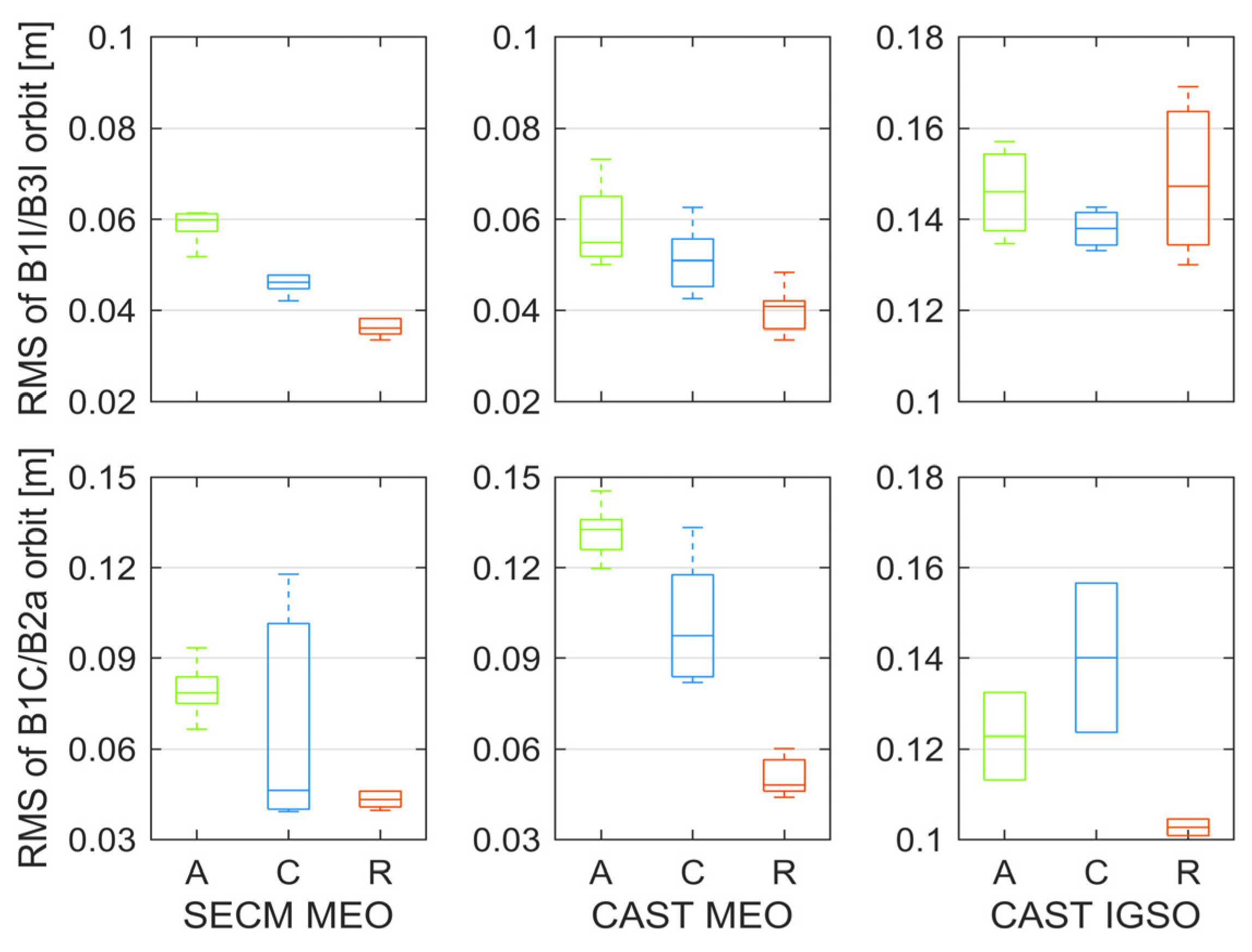
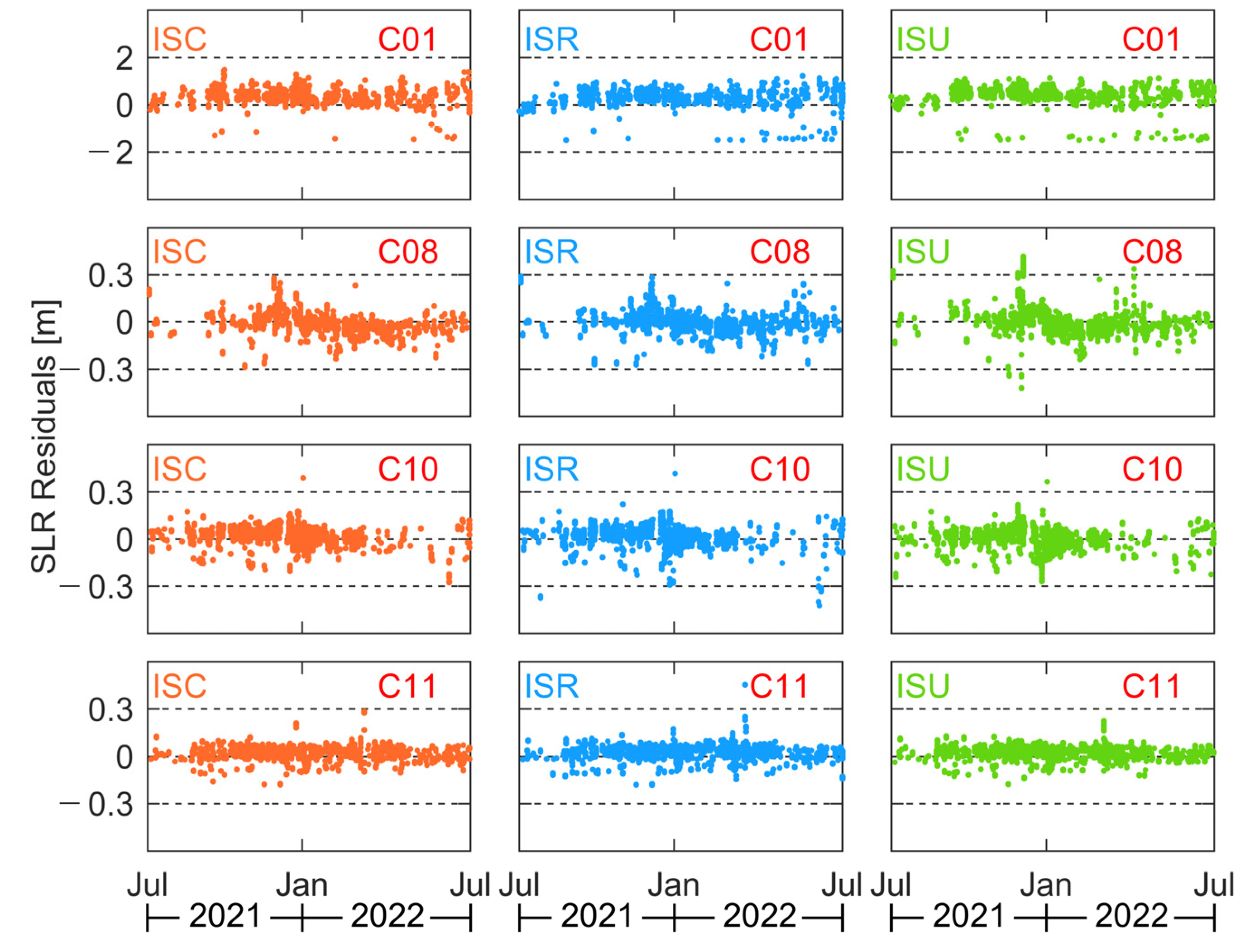
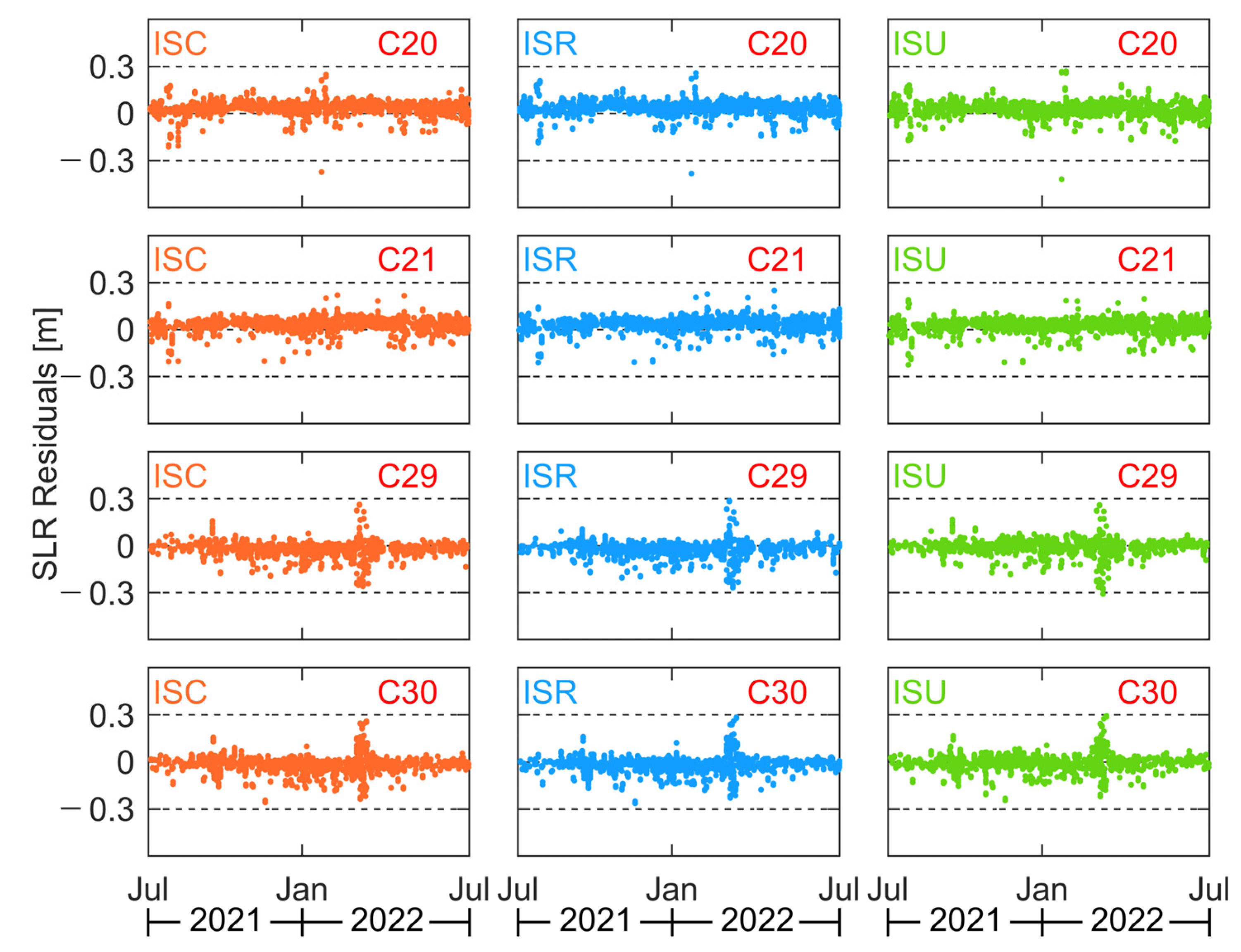
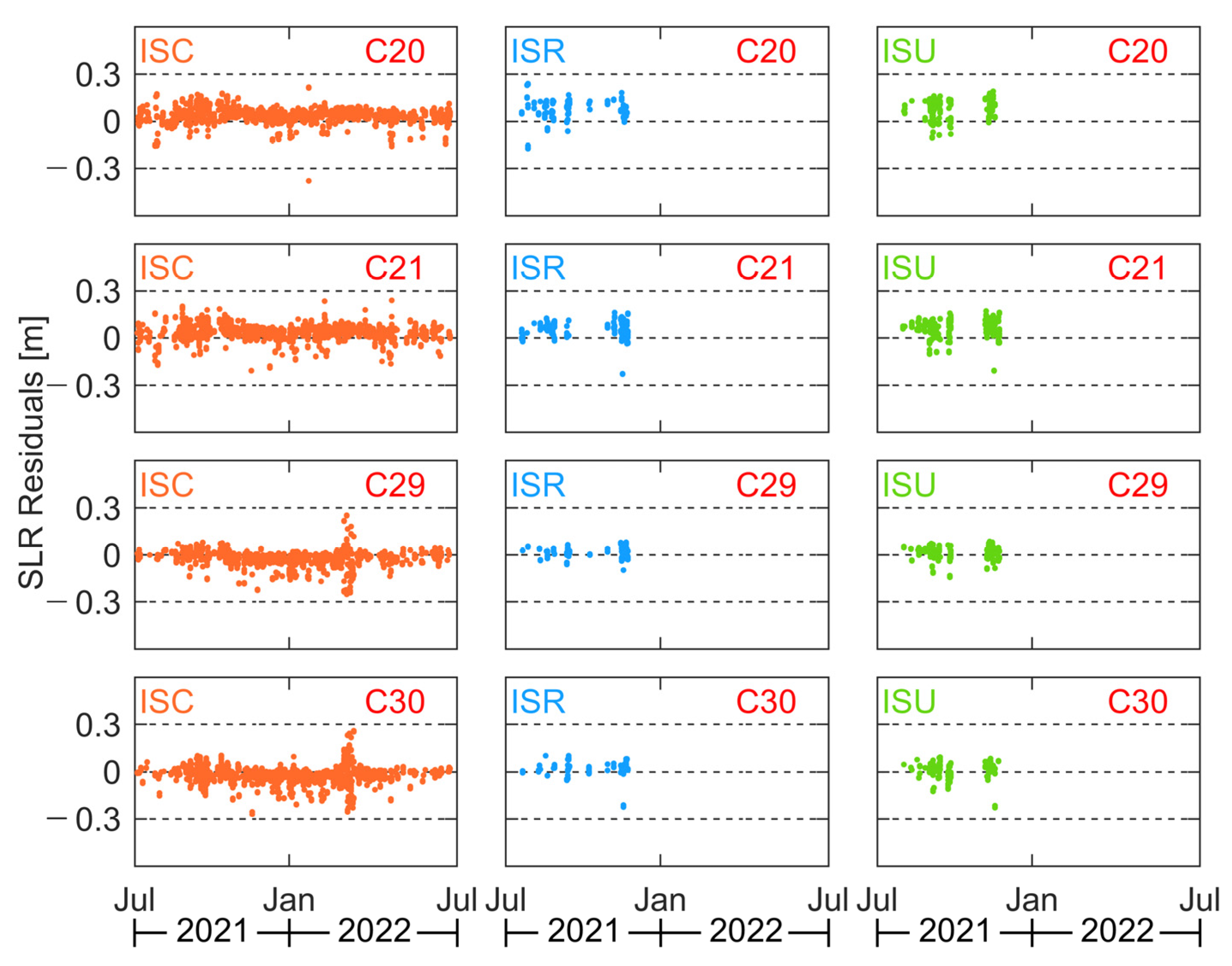
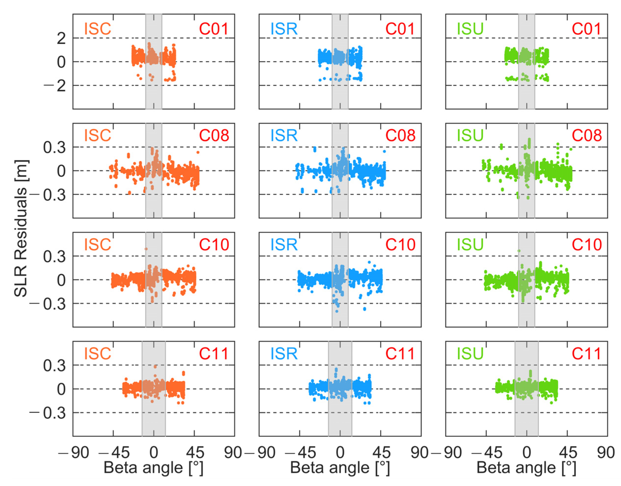
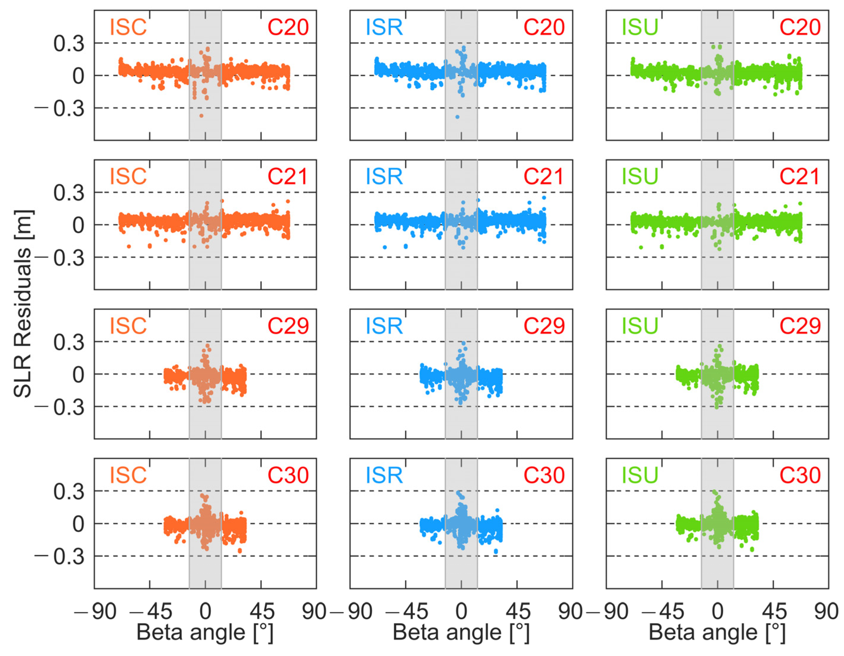
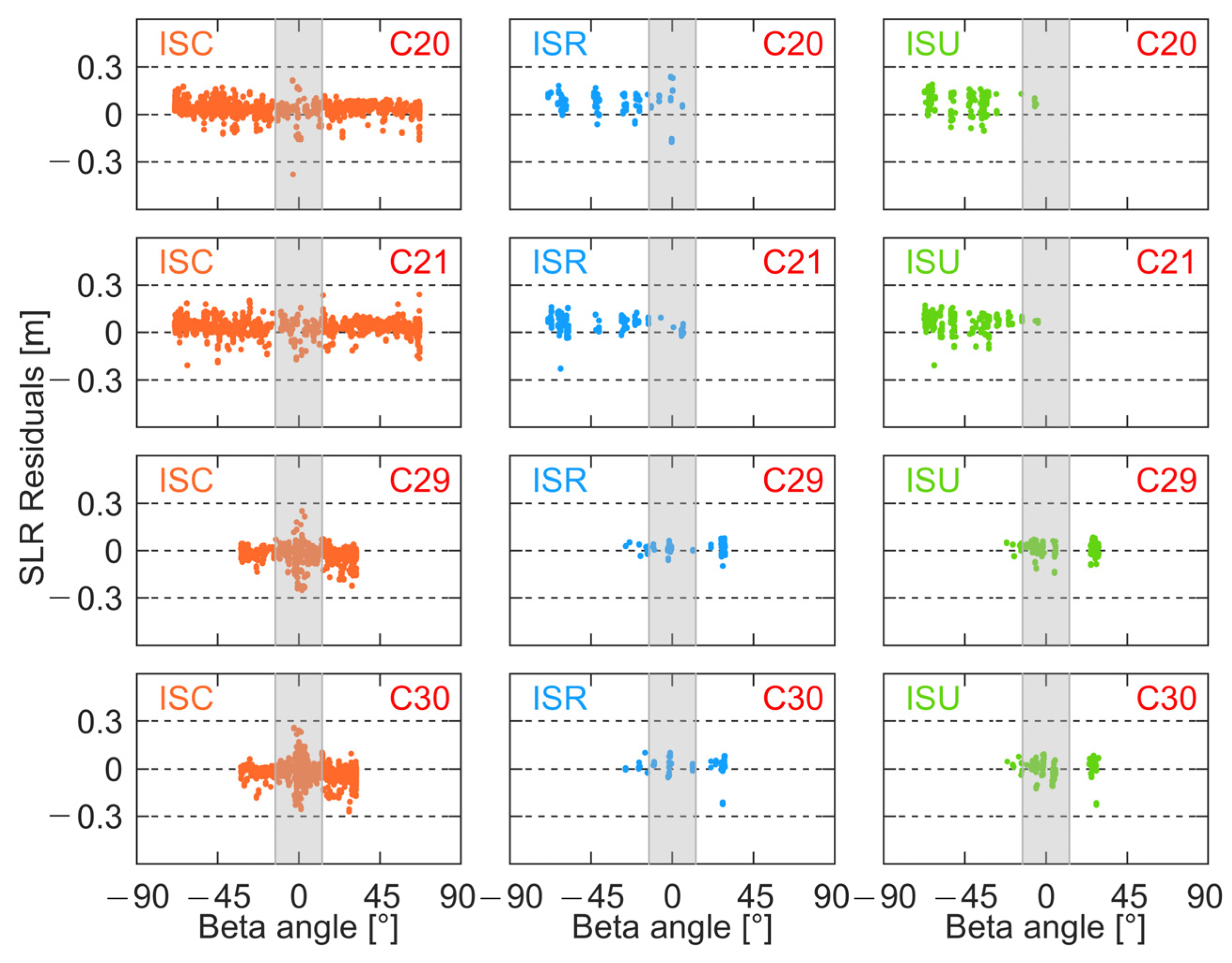
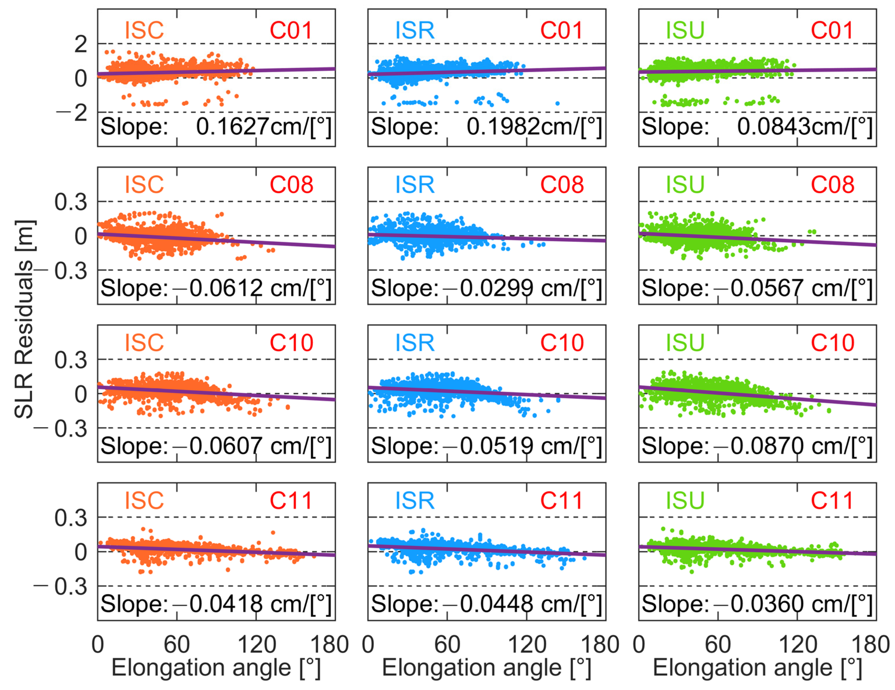
5. Inspection with SLR Residuals
5.1. B1I/B3I Frequencies
5.2. B1C/B2a Frequencies
6. Discussion of Orbit Errors
6.1. Beta Angle
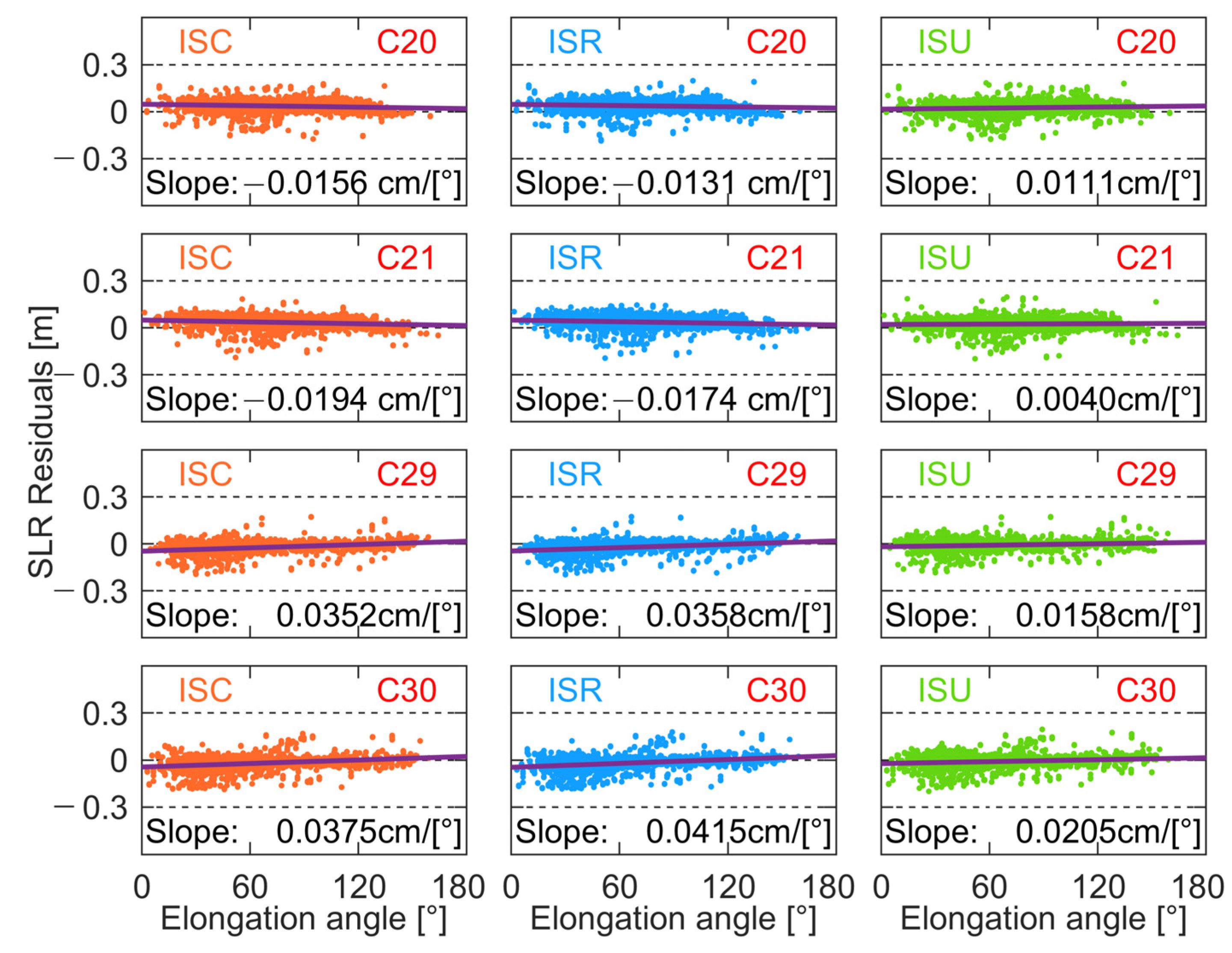
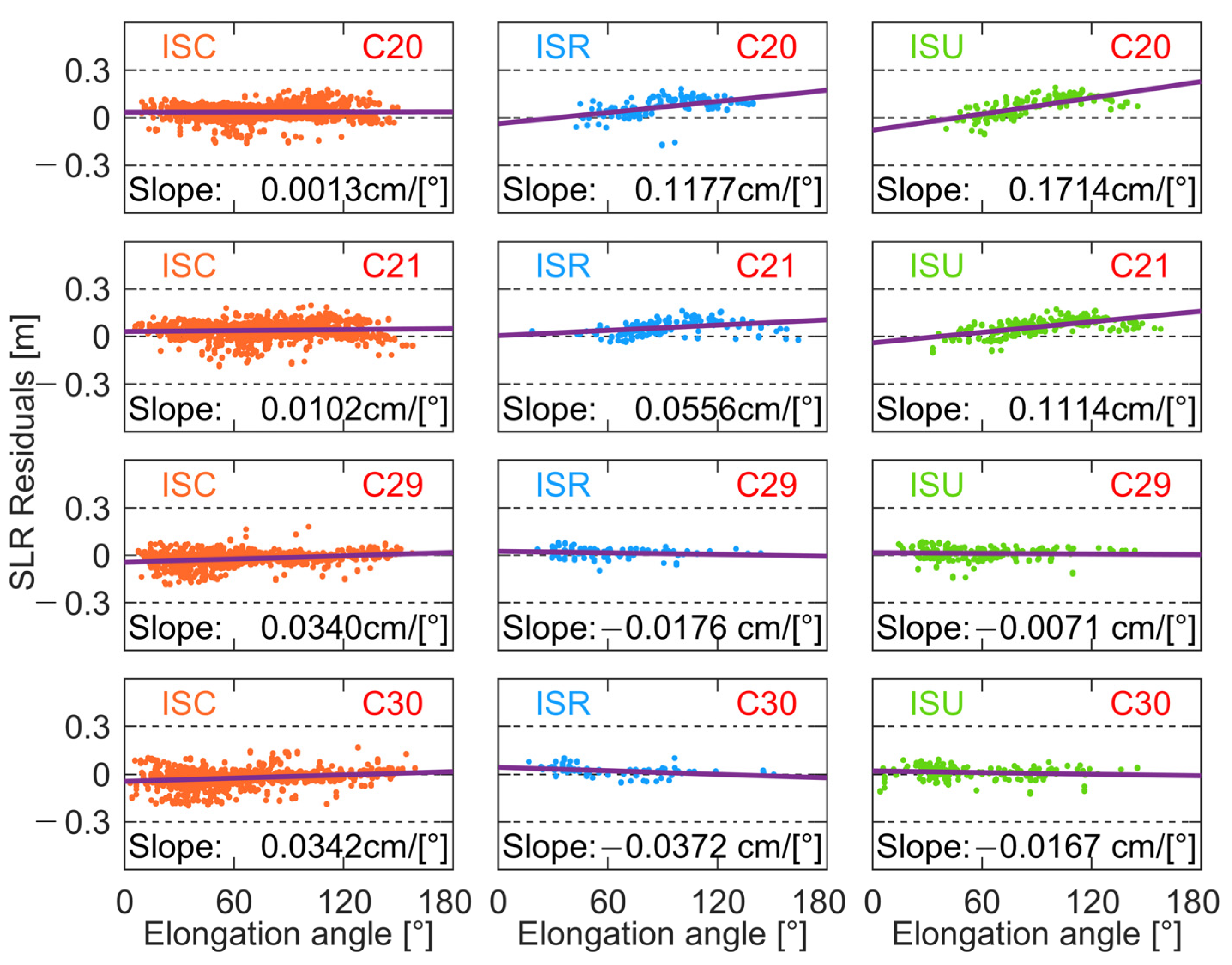
6.2. Elongation Angle
7. Conclusions
Author Contributions
Funding
Data Availability Statement
Acknowledgments
Conflicts of Interest
References
- Yang, Y.; Mao, Y.; Sun, B. Basic Performance and Future Developments of BeiDou Global Navigation Satellite System. Satell. Navig. 2020, 1, 1. [Google Scholar] [CrossRef]
- Yang, Y.; Gao, W.; Guo, S.; Mao, Y.; Yang, Y. Introduction to BeiDou-3 Navigation Satellite System. Navigation 2019, 66, 7–18. [Google Scholar] [CrossRef]
- CSNO BeiDou Navigation Satellite System Signal in Space Interface Control Document Open Service Signal B1C (Version 1.0); China Satellite Navigation Office: Beijing, China, 2017.
- CSNO BeiDou Navigation Satellite System Signal in Space Interface Control Document Open Service Signal B2a (Version 1.0); China Satellite Navigation Office: Beijing, China, 2017.
- CSNO BeiDou Navigation Satellite System Signal in Space Interface Control Document Open Service Signal B3I (Version 1.0); China Satellite Navigation Office: Beijing, China, 2018.
- CSNO BeiDou Navigation Satellite System Signal in Space Interface Control Document Open Service Signal B1I (Version 3.0); China Satellite Navigation Office: Beijing, China, 2019.
- CSNO BeiDou Navigation Satellite System Signal in Space Interface Control Document Open Service Signal B2b (Version 1.0); China Satellite Navigation Office: Beijing, China, 2020.
- CSNO. Fundamental PNT Service. 2022. Available online: http://www.csno-tarc.cn/en/system/constellation (accessed on 1 December 2022).
- Zhao, Q.; Guo, J.; Wang, C.; Lyu, Y.; Xu, X.; Yang, C.; Li, J. Precise Orbit Determination for BDS Satellites. Satell. Navig. 2022, 3, 2. [Google Scholar] [CrossRef]
- Kouba, J. A Guide to Using International GNSS Service (IGS) Products; Maryland Biological Stream Survey; Versar, Inc.: Springfield, VA, USA, 2009; Volume 4, p. 106. [Google Scholar]
- IGS. IGS Analysis Centers. 2022. Available online: https://igs.org/acc/#ac-list (accessed on 1 December 2022).
- Montenbruck, O.; Steigenberger, P.; Prange, L.; Deng, Z.; Zhao, Q.; Perosanz, F.; Romero, I.; Noll, C.; Stürze, A.; Weber, G.; et al. The Multi-GNSS Experiment (MGEX) of the International GNSS Service (IGS)–Achievements, Prospects and Challenges. Adv. Space Res. 2017, 59, 1671–1697. [Google Scholar] [CrossRef]
- Montenbruck, O.; Steigenberger, P.; Khachikyan, R.; Weber, G.; Langley, R.; Mervart, L.; Hugentobler, U. IGS-MGEX: Preparing the Ground for Multi-Constellation GNSS Science. Inside GNSS 2014, 9, 42–49. [Google Scholar]
- Ai, Q.; Maciuk, K.; Lewinska, P.; Borowski, L. Characteristics of Onefold Clocks of GPS, Galileo, BeiDou and GLONASS Systems. Sensors 2021, 21, 2396. [Google Scholar] [CrossRef] [PubMed]
- Jaduszliwer, B.; Camparo, J. Past, Present and Future of Atomic Clocks for GNSS. GPS Solut. 2021, 25, 27. [Google Scholar] [CrossRef]
- Chen, Q.; Song, S.; Zhou, W. Accuracy Analysis of GNSS Hourly Ultra-Rapid Orbit and Clock Products from SHAO AC of IGMAS. Remote Sens. 2021, 13, 1022. [Google Scholar] [CrossRef]
- Kazmierski, K.; Zajdel, R.; Sośnica, K. Evolution of Orbit and Clock Quality for Real-Time Multi-GNSS Solutions. GPS Solut. 2020, 24, 111. [Google Scholar] [CrossRef]
- Zhou, W.; Cai, H.; Chen, G.; Jiao, W.; He, Q.; Yang, Y. Multi-GNSS Combined Orbit and Clock Solutions at IGMAS. Sensors 2022, 22, 457. [Google Scholar] [CrossRef]
- Jiao, W.; Ding, Q.; Li, J.; Lu, X.; Feng, L.; Ma, J.; Chen, G. Monitoring and Assessment of GNSS Open Services. J. Navig. 2011, 64, S19–S29. [Google Scholar] [CrossRef]
- Cai, H.; Chen, K.; Xu, T.; Chen, G. The IGMAS Combined Products and the Analysis of Their Consistency. In Proceedings of the China Satellite Navigation Conference (CSNC) 2015 Proceedings, Xi’an, China, 13–15 May 2015; Springer: Berlin/Heidelberg, Germany, 2015; Volume III, pp. 213–226. [Google Scholar]
- iGMAS. Analysis Centers. 2022. Available online: http://en.igmas.org/About/Showigmas/detail/nav_id/6/cate_id/62.html (accessed on 1 December 2022).
- Ye, F.; Yuan, Y.; Yang, Z. Validation and Evaluation on B1IB3I-Based and B1CB2a-Based BDS-3 Precise Orbits from IGMAS. Adv. Space Res. 2022, 70, 2167–2177. [Google Scholar] [CrossRef]
- Ye, F.; Yuan, Y.; Deng, Z. Improved Ultra-Rapid UT1-UTC Determination and Its Preliminary Impact on GNSS Satellite Ultra-Rapid Orbit Determination. Remote Sens. 2020, 12, 3584. [Google Scholar] [CrossRef]
- Li, Z.; Wang, N.; Wang, L.; Liu, A.; Yuan, H.; Zhang, K. Regional Ionospheric TEC Modeling Based on a Two-Layer Spherical Harmonic Approximation for Real-Time Single-Frequency PPP. J. Geod. 2019, 93, 1659–1671. [Google Scholar] [CrossRef]
- Li, X.; Chen, X.; Ge, M.; Schuh, H. Improving Multi-GNSS Ultra-Rapid Orbit Determination for Real-Time Precise Point Positioning. J. Geod. 2019, 93, 45–64. [Google Scholar] [CrossRef]
- Chen, K.; Xu, T.; Chen, G.; Li, J.; Yu, S. The Orbit and Clock Combination of IGMAS Analysis Centers and the Analysis of Their Precision. In Proceedings of the China Satellite Navigation Conference (CSNC) 2015 Proceedings, Xi’an, China, 13–15 May 2015; Springer: Berlin/Heidelberg, Germany, 2015; Volume II, pp. 421–438. [Google Scholar]
- Tan, B.; Yuan, Y.; Wen, M.; Ning, Y.; Liu, X. Initial Results of the Precise Orbit Determination for the New-Generation BeiDou Satellites (BeiDou-3) Based on the IGMAS Network. ISPRS Int. J. Geo-Inf. 2016, 5, 196. [Google Scholar] [CrossRef]
- Zhang, X.; Li, X.; Lu, C.; Wu, M.; Pan, L. A Comprehensive Analysis of Satellite-Induced Code Bias for BDS-3 Satellites and Signals. Adv. Space Res. 2019, 63, 2822–2835. [Google Scholar] [CrossRef]
- Li, X.; Xie, W.; Huang, J.; Ma, T.; Zhang, X.; Yuan, Y. Estimation and Analysis of Differential Code Biases for BDS3/BDS2 Using IGMAS and MGEX Observations. J. Geod. 2019, 93, 419–435. [Google Scholar] [CrossRef]
- Xie, X.; Fang, R.; Geng, T.; Wang, G.; Zhao, Q.; Liu, J. Characterization of GNSS Signals Tracked by the IGMAS Network Considering Recent BDS-3 Satellites. Remote Sens. 2018, 10, 1736. [Google Scholar] [CrossRef]
- Yang, H.; Xu, T.; Nie, W.; Gao, F.; Guan, M. SLR Validation and Evaluation on BDS Precise Orbits from 2013 to 2018. Adv. Space Res. 2019, 64, 475–490. [Google Scholar] [CrossRef]
- Montenbruck, O.; Steigenberger, P.; Wang, N.; Hauschild, A. Characterization and Performance Assessment of BeiDou-2 and BeiDou-3 Satellite Group Delays. NAVIGATION J. Inst. Navig. 2022, 69, navi.526. [Google Scholar] [CrossRef]
- Arnold, D.; Montenbruck, O.; Hackel, S.; Sośnica, K. Satellite Laser Ranging to Low Earth Orbiters: Orbit and Network Validation. J. Geod. 2019, 93, 2315–2334. [Google Scholar] [CrossRef]
- Zhang, Z.; Li, B.; Shen, Y.; Gao, Y.; Wang, M. Site-Specific Unmodeled Error Mitigation for GNSS Positioning in Urban Environments Using a Real-Time Adaptive Weighting Model. Remote Sens. 2018, 10, 1157. [Google Scholar] [CrossRef]
- Zhang, Z.; Li, B. Unmodeled Error Mitigation for Single-Frequency Multi-GNSS Precise Positioning Based on Multi-Epoch Partial Parameterization. Meas. Sci. Technol. 2020, 31, 025008. [Google Scholar] [CrossRef]


| Institution | ID | Orbit Latency | Orbit Update | Orbit Sampling | Frequency |
|---|---|---|---|---|---|
| iGMAS | ISC | 12 days | weekly | 15 min | B1I/B3I; B1C/B2a |
| ISR | 17 h | daily | 15 min | B1I/B3I; B1C/B2a | |
| ISU | 3 h | 6 h | 15 min | B1I/B3I; B1C/B2a | |
| GFZ | GFZ | daily | daily | 5 min | B1I/B3I |
| ESA | ESA | daily | daily | 5 min | B1I/B3I |
| CODE | COD | daily | daily | 5 min | B1I/B3I |
| WHU | WUM | daily | daily | 15 min | B1I/B3I |
| Item | Strategy |
|---|---|
| Time Span | DOY 190 in 2021 to DOY 190 in 2022 |
| Orbit compare | iGMAS orbit products convert to GPST and are compared with MGEX ACs BDS-2: all of the GEO, IGSO, and MEO satellites BDS-3:C19-C49 (except C31) |
| SLR validation | BDS-2 GEO: C01 BDS-2 IGSO: C08, C10 BDS-2 MEO: C11 BDS-3 CAST MEO: C20, C21 BDS-3 SCEM MEO: C29, C30 |
Disclaimer/Publisher’s Note: The statements, opinions and data contained in all publications are solely those of the individual author(s) and contributor(s) and not of MDPI and/or the editor(s). MDPI and/or the editor(s) disclaim responsibility for any injury to people or property resulting from any ideas, methods, instructions or products referred to in the content. |
© 2023 by the authors. Licensee MDPI, Basel, Switzerland. This article is an open access article distributed under the terms and conditions of the Creative Commons Attribution (CC BY) license (https://creativecommons.org/licenses/by/4.0/).
Share and Cite
Zhang, Z.; Zeng, P.; Wen, Y.; He, L.; He, X. Comprehensive Assessment of BDS-2 and BDS-3 Precise Orbits Based on B1I/B3I and B1C/B2a Frequencies from iGMAS. Remote Sens. 2023, 15, 582. https://doi.org/10.3390/rs15030582
Zhang Z, Zeng P, Wen Y, He L, He X. Comprehensive Assessment of BDS-2 and BDS-3 Precise Orbits Based on B1I/B3I and B1C/B2a Frequencies from iGMAS. Remote Sensing. 2023; 15(3):582. https://doi.org/10.3390/rs15030582
Chicago/Turabian StyleZhang, Zhetao, Ping Zeng, Yuanlan Wen, Lina He, and Xiufeng He. 2023. "Comprehensive Assessment of BDS-2 and BDS-3 Precise Orbits Based on B1I/B3I and B1C/B2a Frequencies from iGMAS" Remote Sensing 15, no. 3: 582. https://doi.org/10.3390/rs15030582
APA StyleZhang, Z., Zeng, P., Wen, Y., He, L., & He, X. (2023). Comprehensive Assessment of BDS-2 and BDS-3 Precise Orbits Based on B1I/B3I and B1C/B2a Frequencies from iGMAS. Remote Sensing, 15(3), 582. https://doi.org/10.3390/rs15030582