Abstract
In the inland closed area of Horqin Sandy Land, China, lakes are the most important source of water, and they maintain the regional hydrological balance and ecosystem health. Clarifying long-term continuous changes of inland lake surface area and water storage in the sandy land is thus of great significance to the management of water resources in arid and semi-arid areas. This study estimated changes in the surface area and water storage of small lakes in the sandy land during 1984–2021 using a multiple index threshold method and an empirical equation based on Shuttle Radar Topography Mission (SRTM) DEM (digital elevation model) data and Landsat 5/7/8 images. Hydro-meteorological variables were also incorporated to explore their potential relationship with changes in the lake elements. The lakes in the sandy land resemble stars or dots, with distinct inhomogeneity. Permanent lakes account for the majority of the total lake area, mostly distributed in the center and east of the study area, whereas most seasonal lakes are small water bodies, with surface areas of 0.1–0.5 km2 and irregularly distributed. Lake surface area and water storage underwent frequent changes during the 38 years, and could be divided into three characteristic fluctuation phases. From 1984 to 1999, the lake surface area fluctuated greatly, and the water storage increased by approximately 0.3732 Gt, with an average expansion rate of 0.0572 Gt/y. Specifically, lakes with a surface area >2 km2 primarily accounted for the expansion. From 1999 to 2004, the lake area shrank sharply to the lowest point, and the water storage capacity decreased by approximately 0.4003 Gt. From 2004 to 2021, the lake surface area and water storage tended to be stable. Annual fluctuations of lake surface area and water storage were mostly affected by precipitation and evapotranspiration, followed by vapor pressure deficit, wet day frequency, and temperature, which have significant periodicity and hysteresis.
1. Introduction
Lakes serve as an important link for water–atmosphere exchange on land [1,2]. Lakes also play a crucial role in the global water cycle and maintaining ecological balance [3]. They can act as a medium for energy transfer at different interfaces and dominate the hydrological evolution mechanism of watershed systems [4,5]. The formation and disappearance, expansion and contraction, and evolution of the water ecology of lakes are the result of interactions among regional and local structures, as well as the climate and environment [6,7]. Some inland lakes are located at the tail-end of rivers or in an independent catchment area, and lake water does not discharge into the sea [8]. China’s inland lakes are mainly distributed in areas such as the Inner Mongolia Autonomous Region, the Xinjiang Uygur Autonomous Region, and Gansu Province. In particular, inland lakes in desertification areas are an important water resource for sandy lands, but their ecological environment is fragile, complex, and highly sensitive [9,10]. Therefore, such lakes can be used as a terminal indicator of regional hydrological cycles and environmental change.
In recent years, under the influence of complex factors, such as the increased frequency of climate anomalies and excessive interference of human activities, lakes have changed by varying degrees [11]. For instance, under the combined action of climate warming and groundwater change, the number and surface area of lakes in northern China have decreased, and some small lakes have even dried up. Specifically, the lake surface area of the Inner Mongolia Plateau alone decreased by 1223.76 km2 [12,13]. In addition, the melting of glaciers and the increase of precipitation have led to the rapid expansion of most lakes and the rise of water levels on the Tibetan Plateau, resulting in the inundation of pastures and the destruction of highways and bridges, which have had a serious impact on the local economy and ecology [14,15]. In summary, it is urgent to monitor the spatio-temporal characteristics of lakes in the long term, so as to provide scientific guidance and important support for the ecological protection and restoration, and sustainable development of resources and the environment.
The traditional approach to lake monitoring is to obtain water level, shoreline, and other data directly through hydrological stations and manual observations. However, this approach has various shortcomings in that it is time-consuming and has limited spatial scope, among others. The remote areas and intricate topography of the Horqin Sandy Land make it difficult for researchers to conduct field measurements. Moreover, the region is lacking historical data or even station observations. Consequently, with the help of remote sensing technology, which can provide a long-time series of large-scale lake change information in a convenient and rapid manner [16]. It has become an important means for monitoring the dynamic changes of lake elements [17]. Nevertheless, the intricate nature of the underlying surface in desertified areas leads to the predominance of small, widely distributed lakes that are typically less than 10 km2 in size [13,18]. As a result, remote sensing techniques face substantial challenges when monitoring the dynamic changes in lake elements. At present, some water products have been made available in China and abroad, such as the global water data set (JRCGSW) and HydroLakes data set [19,20]. However, the identification of small lakes in many regions using these products is limited by misclassification, which can introduce uncertainties in the results. Furthermore, the widely used method based on a single water body index often has low accuracy when applied in desertification regions [21,22]. Moreover, due to differences in lake topography, changes in lake surface area cannot fully reflect the lake’s response to climate and environmental changes, but lake vertical information such as changes in water storage can effectively compensate for it [23]. Altimetry satellites such as ICESat and Jason1/2/3 are often used to estimate lake water storage capacity [24,25]. Many scholars use the directly obtained lake surface area and water level changes to estimate the lake water volume by establishing a water balance model [23,26]. However, existing altimetry satellites offer long-term coverage for only a few large lakes, and the estimation of lake water storage capacity in other areas without water level data remains uncertain. Thence, there is an urgent and essential need for a comprehensive investigation of the long-term dynamic changes in lake elements in this region. Worthy of attention is the recent launch of the SWOT (Surface Water Ocean Topography) satellite. With its wide-range altimetry technology, it will provide new support for future surface water research through repeated high-resolution elevation measurements.
The study of the relationship between lakes and climate change has become a hot topic [18,27,28]. The researchers qualitatively and quantitatively explored the intrinsic and extrinsic factors that lead to the dynamic changes of the lake, whether from large-scale atmospheric circulation (such as ENSO, PDO, etc.) or local climate fluctuations, which all play an important role in it. Previous studies have shown that meteorological factors are considered the main driving factors affecting the change of inland lakes [29]. The response of lakes exhibits temporal and spatial differences in different regions to different hydro-meteorological factors [28]. Fan et al. suggested that the annual fluctuation of water storage in Hulun Lake is mainly affected by precipitation [30]. In contrast, the reduction in the surface area of Bosten Lake is directly determined by the increase in annual average evaporation [31]. Temperature change plays a leading role in Selincuo Lake and Namucuo Lake [32]. In general, existing studies have explored the response of the dynamic changes of large lakes to climate, but the relationship between small inland lakes in sandy land and climate change has rarely been investigated. Therefore, it is necessary to fill this gap and clarify the impact of climatic and hydrological factors on changes in small inland lakes in sandy land.
Considering the above limitations, this study selected small lakes in the inland closed flow area of Horqin Sandy Land in northern China as the research object. In this study, changes in the lake surface area and water storage of inland lakes in the sandy land during 1984–2021 were first analyzed using Landsat images and SRTM data. Then, the long-term relationship between hydro-meteorological factors and lake elements was determined. The objectives of this study were to (1) accurately estimate lake surface area and water storage changes, (2) clarify the temporal and spatial distribution of changes in lake surface area and water storage, and (3) reveal the potential relationship between lake dynamic changes and hydro-meteorological factors.
2. Materials and Methods
2.1. Overview of Study Area
The study area (42°39′00″–43°42′00″N, 121°50′00″–123°20′00″E) is located in the closed basin of the southeast margin of Horqin Sandy Land in North China, with an area of approximately 8000 km2 (Figure 1). The region is controlled by the semi-arid continental monsoon climate in the temperate zone. The annual mean temperature is 6.7 °C and the annual mean evapotranspiration is 1412 mm (∅20 cm evaporating dish). The annual mean precipitation is 389 mm, which is approximately 1/4 of the evapotranspiration, and mainly occurs from June to September. The overall topography is high in the southwest and low in the east, with an elevation of 132 m to 296 m. The region is rich in groundwater and surface water resources. The underground aquifer is generally a unified phreatic aquifer composed of Quaternary loose strata, with a thickness of approximately 100–200 m, thickening from west to east and from south to north. Small lakes and blisters, which are closed lakes, on the surface are mostly formed by surface runoff or underground runoff in low-lying areas (Figure 1). Therefore, the region presents a unique geomorphological type of sand dune–meadow–lake (Figure 1). Wetland meadow vegetation, such as Phragmites australis, Leymus chinensis, and Scirpus yagara, are mainly distributed near lakes and blisters in the study area, with crops such as Oryza sativa Lam, Zea mays Lam, and Glycine max Merr. The vegetation in the dune area far from lakes mainly comprises desert vegetation, such as Caragana microphylla, Salix gordejevii, Artemisia halodendron, Corispermum hyssopifolium, and Tribulus terrestris, and natural trees such as Ulmus pumila Lam and Armeniaca sibirica Lam, or artificially planted poplar such as Populus davidiana.
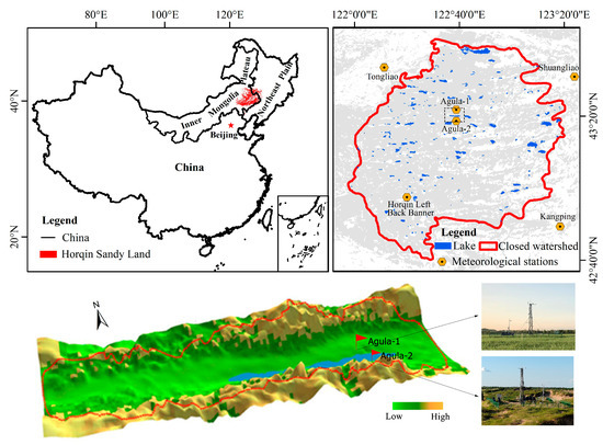
Figure 1.
Geographical location and lake distribution of the study area.
2.2. Data and Processing
2.2.1. Multi-Temporal Landsat Image and Digital Elevation Model (DEM) Data
A total of 2777 Collection 1 Tier 1 images of Landsat 5 TM, Landsat 7 ETM+, and Landsat 8 OLI from 1984 to 2021 were obtained based on the Google Earth Engine (GEE) (https://earthengine.google.com/, accessed on 10 March 2023) (Figure 2a). The Landsat Collection 1 Tier 1 images were conducted with geometric and atmospheric correction, as well as cross-calibration among the different sensors [33]. The temporal resolution of the images is 16 days and the spatial resolution is 30 m. All acquired images were screened for cloud cover (cloud cover < 10%), and the data quality layer from the CFmask algorithm for cloud masking was used to remove invalid pixels such as clouds and cloud shadows. Then, by using the solar azimuth and zenith angle of Landsat images and DEM to remove terrain shadows, the preprocessed high-quality images were used to extract the lake area (the number of high-quality images was 1354) (Figure 2b). Among them, the scan line corrector fault had occurred in the Landsat 7 ETM+ images since 2003, which led to image striping. Therefore, within the GEE platform, gaps in the Landsat ETM + SLC-off images were removed using the method of focal statistics, utilizing the functions ‘ee.Image.focal_mean’ and ‘ee.Image.blend’.
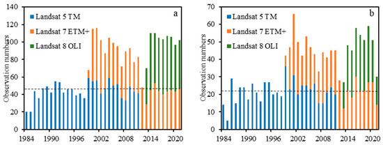
Figure 2.
The total number of Landsat observations (a) and the number of high-quality images (b) in the study area from 1984 to 2021, where the dotted line is the annual average number of observations.
The Shuttle Radar Topography Mission (SRTM) is an eleven-day global surface remote sensing mission completed in February 2000 by NASA and NIMA, as well as German and Italian space agencies. Through this mission, global DEM data covering more than 80% of the Earth have been obtained [34]. The data have high accuracy for regions in China, such as the inland flow area of the Tibetan Plateau and Inner Mongolia Plateau [15,23,29,35]. The entire data set can be divided into 1″ SRTM1 and 3″ SRTM3 according to the accuracy. In this study, STRM1 data (source: GEE) with a resolution of 30 m were selected to establish the relationship between lake surface area and lake surface elevation.
2.2.2. Meteorological and Hydrological Data
Two sets of Bowen ratio system meteorological stations installed in the study area by the Agula Ecohydrology Experimental Station of Inner Mongolia Agricultural University were selected (Figure 1). All the stations are equipped with temperature and humidity probes (CS655, Campbell Scientific Inc., Logan, UT, USA), rain gauges (TE525MM, Texas Electronics, Dallas, DT, USA), air temperature and humidity measuring instruments (HMP155A, Campbell Scientific, Logan, UT, USA), and other sensing equipment. Relevant monitoring elements were calculated and stored by the data collector (CR1000, Campbell, Logan, UT, USA) with an interval of 30 min or 1 day. Four national meteorological stations in and around the study area (Figure 1) were selected as follows: Horqin Left Back Banner Station and Tongliao Station in the Inner Mongolia Autonomous Region, Kangping Station in Liaoning Province, and Shuangliao Station in Jilin Province. The data were obtained from the China Meteorological Data Sharing Service System (http://data.cma.gov.cn/, accessed on 10 March 2023). In this study, four daily/monthly climatological and hydrological variables, which are closely related to lake changes, during the ice-off period (April–October) from 1984 to 2021 were selected. These variables included precipitation (P), temperature (T), relative humidity (RH), evapotranspiration (ET), wet day frequency (WET), and vapor pressure deficit (VPD). Specifically, WET and VPD were calculated using Equation (1) [36] and Equation (2) [37], respectively.
where DP is the daily sequence of daily precipitation, starting from the 1st of each month; each single-day precipitation is counted in turn: 1, 2, …, . The value of ranges from 1 to 31.
2.3. Methods
2.3.1. Extraction of Lake Surface Area and Accuracy Assessment
In remote sensing images, water bodies with low reflectance can be misidentified as shadow and vegetation. Moreover, the accuracy of lake identification based on a single band or a single index is often limited, especially for small lakes [38]. In this study, the Modified Normalized Difference Water Index (MNDWI), Normalized Difference Water Index (NDWI), Normalized Difference Vegetation Index (NDVI), and Enhanced Vegetation Index (EVI) were comprehensively selected to identify the lake boundary. The extraction threshold and rules are NDWI > 0 and EVI < 0.1, and MNDWI > EVI or MNDWI > NDVI.
The expression of each index is as follows:
where is the green band, is the short wavelength infrared band, is the near infrared band, is the red band, and is the blue band.
Additionally, in order to further classify the lake type, the stagnant water frequency (WF) is introduced, that is, the ratio of the number of times that any pixel position is identified as a water body to the total number of times that pixel is well observed in a period of time (Equation (7)) [39]. Based on the WF value of each pixel position in that year, pixels with WF > 0.75 were set as a permanent lake and those with 0.25 < WF ≤ 0.75 as a seasonal lake [13,39,40]. The above steps are handled on GEE. All the obtained data were projected into the Albers Conical Equal Area coordinate system using ArcGIS 10.5 software to calculate the lake surface area, and scattered small water bodies (<0.1 km2) were removed to obtain the spatial distribution and surface area of continuous small inland lakes in Horqin Sandy Land from 1984 to 2021.
where is the number of total Landsat high-quality observations of the pixel in years, denotes that one observation of the pixel is water, with indicating water and indicating non-water.
We use historical high-definition images of Google Earth to verify the accuracy of the extracted sand surface water. A total of 400 test samples were randomly generated by using the ‘Create Evaluation Point’ function in ArcGIS in the study area in 1990, 2000, 2010, and 2020, including 200 water samples and 200 non-water samples (Figure 3). The corresponding Google Earth historical images of each year were loaded into the ArcGIS layer and detected by visual interpretation. At the same time, we selected 10 typical lakes to further verify the accuracy of the results by delineating the region of interest (i.e., lake region) from the historical high-definition images of Google Earth in 2000 (Figure 3).
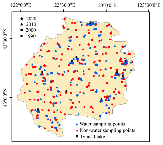
Figure 3.
Spatial distribution of 400 test sampling points (200 points for water and 200 points for non-water) and 10 typical lakes.
2.3.2. Estimating Water Storage Change
Suppose the lake is a regular lake basin. Then the underwater topography of the lake can be regarded as the continuation of the water surface area topography with similar characteristics, and the topographic characteristic parameters (such as topographic height difference and average elevation) on the lake surface and above the lake surface can be used as the characterization index of underwater topography. Thus, through analysis and construction of a linear functional relationship between the elevation above the lake water surface, plane area, and volume increment, it is possible to deduce the water storage change corresponding to the water surface area below the water surface [23]. The concept map is shown in Figure 4.
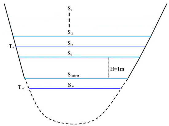
Figure 4.
Estimation of lake water storage based on SRTM data.
Therefore, based on SRTM data, raster data were converted into vector data using the elevation value with an interval of 1 m in ArcGIS 10.5 software. According to the distribution of lakes in 2000, lakes could be divided into four regions according to their elevation: <150 m, 150–200 m, 200–250 m, and >250 m, respectively. Firstly, lakes with different surface areas in each elevation interval were randomly selected, as shown in Figure 5a. The lake area, SSRTM, extracted by SRTM and the surface area, Si (i = 1, 2, …), with closed vector polygons as elevation at the equidistant H (1 m) of each lake were calculated. Then, according to the empirical equation (Equation (8)), the water storage change ΔV can be calculated from SSRTM to S1, and S1 to S2, and so on. In other words, a unit change in water storage change ΔV is a 1 m change in elevation. By summing the change in water storage with an elevation increment of 1 m, the water storage change with different elevation distances under SSRTM can be calculated. Finally, by constructing the linear relationship between the elevation area and volume increment of the lake surface and above, the numerical relationship model between the lake surface area and the corresponding water storage change can be deduced (Figure 5b). When the lake surface area at the time of Tn and Tm is known based on the linear relation model, the water storage change compared with February 2000 can be estimated.
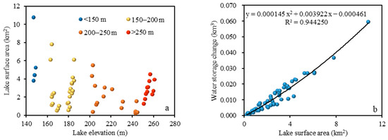
Figure 5.
Relationship between lake elevation, lake surface area, and water storage change. (a) Lake surface area and lake elevation distribution; (b) relationship between lake surface area and water storage change.
For example, Baga Yaolu Nur Lake (42°50′44.04″, 122°18′55.80″) is located in an area with an elevation >250 m. Based on SRTM data, the lake surface elevation of Baga Yaolu Nur Lake in February 2000 was measured to be 253 m, and the corresponding lake surface area was 2.1980 km2. The corresponding values with the increase every 1 m of elevation are shown in Table 1. Owing to the significant variation in elevation among the lakes in the region, typical lakes of various sizes within each elevation range were selected and aggregated. A numerical model was then established by correlating the lake area (such as the third column) with the corresponding water storage change (such as the fifth column) (Figure 5b).

Table 1.
The relationship among lake elevation, lake surface area, and water storage change in Baga Yaolu Nur Lake from SRTM.
2.3.3. Lake Water Balance Equation
Climate change and human activities cause changes in lakes by affecting the recharge and loss terms of the water balance. Based on the basic method of lake water balance (Equation (9)), this study used the data fitting function in Matlab 2023 software to construct an empirical model after derivation and generalization. To analyze the response of climate and human activities to the changes in the lake surface area and water storage. The water balance equation of a lake can be expressed as:
where is the amount of water storage change in the lake, is the total volume of water entering the lake, is the total water volume out of the lake, is the evaporation of lake water, and is the amount of water loss from the lake influenced by non-climatic factors such as human activities.
3. Results
3.1. Accuracy Evaluation
Table 2 shows the accuracy of surface water bodies in sandy land extracted in this study. The overall accuracy and Kappa coefficient were 95.25% and 0.91, respectively. This shows that the extracted water body has high accuracy and can be used for further analysis.

Table 2.
The confusion matrix for accuracy assessment of extracting water body.
We selected 10 typical lakes, and the coordinates of the lake centers are shown in Table 3. The results show that the average relative error of the lake surface area extracted in this study is 2.6% compared with the Google Earth image (Table 3), which indicates that the accuracy of the extracted sandy lake surface area is relatively high.

Table 3.
The typical lake surface area extracted from Landsat and Google Earth images in 2000.
To evaluate the accuracy of SRTM data, we conducted a comparison between the lake surface area derived from SRTM data and the lake surface area computed from Landsat images in 2000, using comparable similar values of lake surface elevation since the elevation of the lake surface is relatively invariable. Figure 6 shows the good consistency between the areas derived using SRTM and those from Landsat images, with a correlation of 0.996 for ten typical lakes. The results show that SRTM data exhibit high accuracy and have better performance. In this study, only relative elevation changes were used to estimate storage changes, so the SRTM data are sufficiently reliable for this study.
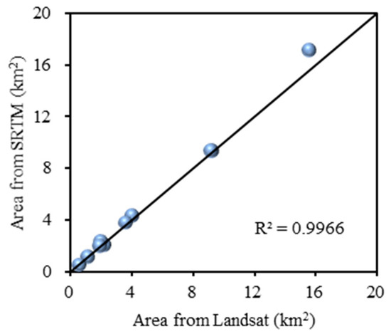
Figure 6.
Comparison of typical lake surface areas derived using SRTM data and Landsat images.
3.2. Temporal Variation Characteristics of Lake Surface Area
In order to quantify the evolution of lakes in the inland closed watershed of Horqin Sandy Land from 1984 to 2021, lakes in the past years were divided into four intervals according to their surface area size, namely 0.1–0.5 km2, 0.5–1 km2, 1–2 km2, and >2 km2, respectively. Figure 6 shows the changes in surface area and number of permanent lakes (Figure 7a) and seasonal lakes (Figure 7b) over the years. Changes in the area and quantity of both permanent and seasonal lakes appear to be holistic. In other words, no inconsistent phenomenon of individual shrinkage or expansion was observed in any year. Lake changes during the 38 years could be divided into three stages. The first stage was from 1984 to 1999, and the lake surface area fluctuated widely. During this period, the surface area and number of seasonal lakes reached the maximum in 1994 of 114.57 km2 and 201, respectively. For permanent lakes, the surface area and number of lakes reached the maximum in 1995 (154.56 km2 and 154, respectively). The second stage was from 1999 to 2004, during which lakes shrank sharply, showing a significant downward trend, with a surface area change rate of −25.35. The surface area and number of permanent lakes and seasonal lakes reached the minimum in 2004. The third stage was from 2004 to 2021, during which lakes tended to be stable as a whole, with little fluctuation.
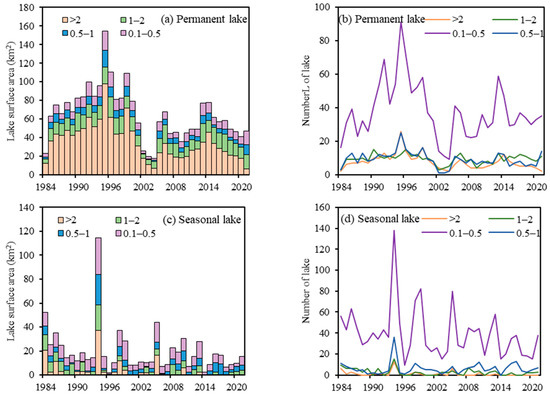
Figure 7.
Changes in the number and surface area of lakes in the study area from 1984 to 2021. (a) The surface area of permanent water bodies; (b) the number of permanent water bodies; (c) the surface area of seasonal water bodies; and (d) the number of seasonal water bodies.
Specifically for permanent lakes (Figure 7a,b), the number of lakes of >2 km2 was the smallest in the region. However, these lakes accounted for the largest proportion of permanent lakes. In contrast, the number of lakes of 0.1–0.5 km2 accounted for 57–60% of the total number of lakes in each year. Regarding seasonal lakes (Figure 7c,d), they are mainly small water bodies, and the number and surface area of lakes of 0.1–0.5 km2 were larger than those of other lakes. In particular, there was a sudden increase in seasonal water bodies in 1994, as much as 10 times that in the past five years. During the 38 years, seasonal lakes of 1–2 km2 and >2 km2 with larger surface areas disappeared continuously, and the surface area and number tended towards zero.
3.3. Spatial Differentiation Characteristics of Lake Surface Area
Based on the temporal variation law of lakes in the study area, four years (1984, 1999, 2004, and 2021) were selected to visualize the spatial distribution of lakes. As shown in Figure 8, the lakes were generally widely distributed, exhibiting distinct inhomogeneity. Most of the permanent lakes were clustered and concentrated in the center and east of the study area, while the seasonal lakes were randomly scattered. When lakes expanded (such as in 1999) or shrunk (such as in 2004), seasonal lakes significantly increased or decreased (disappeared), followed by the increase or decrease of smaller permanent lakes. Different types of lakes showed different changes in surface area in the study area from 1984 to 2021 (Table 4). Seasonal lakes showed the largest transformation, with changes in the surface area of seasonal lakes accounting for 58% of the total conversion of surface area. Although permanent lakes were relatively stable because of their large surface area, the total changes in the surface area of permanent lakes still amounted to 22.7521 km2. In the past 38 years, the decrease of lake surface area was mainly attributable to the disappearance of seasonal lakes, with a surface area change of 25.2147 km2, accounting for nearly one third of the total conversion of surface area. Among them, the conversion of surface area from permanent lake to seasonal lake was the lowest at only 0.8365 km2.
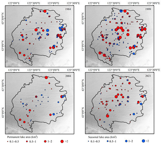
Figure 8.
Spatial distribution of different types of lakes from 1984 to 2021.

Table 4.
Transfer matrix of lake types from 1984 to 2021 (in km2).
3.4. Water Storage Change
This study investigated the changes in permanent lake water storage from 1984 to 2021 in the study area. As shown in Figure 9 and Figure 10, the lake surface area showed an expanding trend from 1984 to 1999, and the water storage of the permanent lakes increased by approximately 0.3732 Gt (1 Gt = 1 km3, assuming the lake water density is 1000 kg/m3). During this period, the expansion rate of lakes from 1989 to 1995 was higher than that in other periods, and the water storage of permanent lakes increased by approximately 0.3432 Gt, with an average expansion rate of 0.0572 Gt/y. Most of the areas with larger increments were distributed in lakes with a surface area larger than 2 km2. From 1999 to 2004, the water storage of regional permanent lakes was consistent with the total surface area, and decreased sharply. The water storage of permanent lakes decreased by approximately 0.4003 Gt in these 5 years, which was three times as much as that in the previous 10 years. After 2004, with the increase of the lake surface area, the water storage of permanent lakes also rebounded, which was widely distributed, and the water storage of sporadic lakes decreased, mainly at the southern and northern boundaries of the study area. In the past 16 years, the water storage of permanent lakes fluctuated in a small range of increase-decrease-increase-decrease, and the fluctuation range was maintained between 0.1398 Gt and 0.3071 Gt. From 2004 to 2021, the water storage of permanent lakes increased by 0.0835 Gt, but it decreased in comparison with 2014. During this period, the water storage increased in 2004–2006 (0.1953 Gt) and 2009–2014 (0.1674 Gt), with increase rates of 0.0977 Gt/y and 0.0335 Gt/y, respectively. Water storage decreased during 2006–2009 (−0.1229 Gt) and 2014–2021 (−0.1562 Gt), with decrease rates of 0.0410 Gt/y and 0.0223 Gt/y, respectively. From 2004 to 2021, water storage clearly showed a trend of rapid increase and slow decrease. During the 38-year period, the decrease of the water storage of permanent lakes was concentrated in larger lakes in the eastern part of the region, while the increase of the water storage of permanent lakes was mainly in the northern and middle parts of the region.
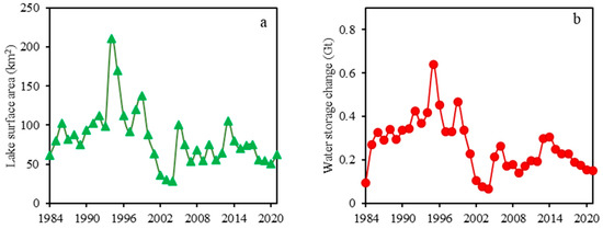
Figure 9.
Total lake surface area (a) and water storage change (b) of permanent lakes from 1984 to 2021.
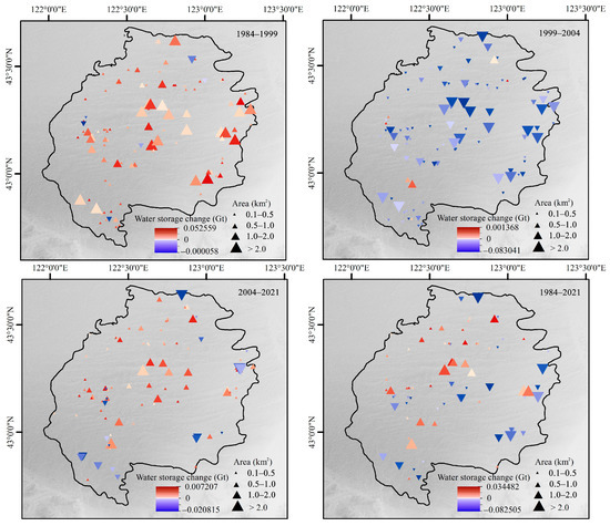
Figure 10.
Spatial distribution of water storage changes of permanent lakes from 1984 to 2021.
3.5. Relationship between Lake Surface Area, Water Storage Change, and Hydro-Meteorological Variables
The hydro-meteorological variables showed synchronicity in Horqin Sandy Land on the temporal scale, namely the annual and monthly variation characteristics of precipitation, temperature, evapotranspiration, vapor pressure deficit, and wet day frequency, as shown in Figure 11. The annual cumulative precipitation showed a fluctuating and decreasing trend as a whole, and the range of change varied in different periods. During the study period, the average annual precipitation was 441.63 mm, and the high-precipitation periods were 1994 (583.60 mm), 1998 (628.73 mm), 2005 (593.50 mm), 2012 (602.97 mm), and 2016 (589.03 mm), which were consistent with the total surface area of high lakes and seasonal lake surface areas in the 1990s. Except for 2012, the lake surface area and water storage changes showed an increasing trend in each corresponding year. Notably, seasonal scattered small lakes are highly sensitive to climate change, leading to large fluctuations in their surface area. Although the lake surface area did not increase in 2012, it only decreased by 1.07%, and the water storage change displayed an increasing trend in 2012. As the annual precipitation is mainly concentrated from June to September, heavy precipitation events were distributed in July or August (Figure 11a). Therefore, the period of large increases in the surface area of permanent lakes and large changes in water storage showed a lag of approximately one year in general, such as in 1995, 1999, and 2006.
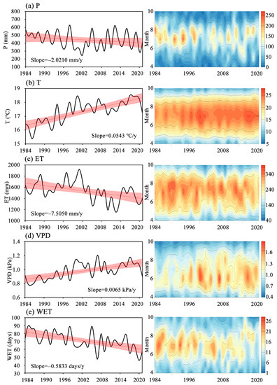
Figure 11.
Annual/monthly changes in meteorological and hydrological variables from 1990 to 2020.
The change in regional annual mean temperature was relatively strong, opposite to that of the annual cumulative precipitation, and showed an upward trend with periodic fluctuations (Figure 11b). The annual average temperature in 2021 was 0.78 °C higher than that in 1984, and the change rate was approximately 0.20 °C/10 y. The frequency of high temperature (>24 °C) in the last 5 years was higher than that in the previous years, and the duration of high temperature within a year was significantly increased. The rise of temperature aggravated the trend of drought in Horqin Sandy Land, which led to the change in vegetation cover in the region [41]. As a result, the permanent lake surface area and water storage continued to decline even in high precipitation years (such as in 2016 and 2019), with reductions of 4.40 km2 (0.0203 Gt) and 2.52 km2 (0.0111 Gt), respectively, compared with the previous year.
As shown in Figure 11c,d, the periodic variation model of annual cumulative evapotranspiration is basically consistent with the vapor pressure deficit, which indicates a strong correlation between the two variables. The vapor pressure deficit showed a slight upward trend as a whole (slope = 0.0065 kPa/y), which further indicates that the region tended to be arid. However, the annual cumulative evapotranspiration showed a downward trend as a whole (slope = −7.5050 mm/y), and evapotranspiration during the year was mainly concentrated from June to August, accounting for 53–63% of the total frost-free period. Meanwhile, the vapor pressure deficit was mainly concentrated from May to June. Since the beginning of the 20th century, the vapor pressure deficit has expanded to July–August. The rapid decrease of the lake surface area and water storage occurred during 1999–2004, while the corresponding evapotranspiration and vapor pressure deficit were high. On the contrary, the lake surface area and water storage showed an overall fluctuating increase from 2004 to 2013. During this period, the evapotranspiration and vapor pressure deficit fluctuated and decreased to −32.0303 mm/y and −0.0138 kPa/y, respectively, with a significant negative correlation.
The wet day frequency can indicate the degree of wetness or drought in a certain year, which has a certain influence on the change in lake surface area or water storage capacity. From 1984 to 2021, the wet day frequency ranged from 46 to 90 days. In particular, the highest value of 90 days appeared in 1985, followed by 89 days in 1998 and 2005. However, the precipitation in 1998 was higher than that in 2005, indicating that the precipitation in 1998 was a short-term heavy precipitation event, mainly concentrated in July. Therefore, the sudden expansion of the seasonal lake surface area reached its peak in 1998, while the peak value of the permanent lake surface area and water storage appeared in the next year. In 2005, the lake surface area and water storage showed synchronous growth. As shown in Figure 11e, frequent wet days were mainly concentrated in June and July.
In order to analyze further the influence of climate and human activities on changes in the regional lake surface area and water storage, lake surface area () and water storage changes () in year t were selected as dependent variables. The two most important hydro-meteorological parameters affecting the lake, precipitation, and evapotranspiration, were selected as independent variables (Figure S1). In addition, changes in lake surface area () and water storage () in the previous year were further selected as independent variables. At the same time, time () was used to characterize the persistent and enhanced disturbance of human activities. It was defined as 0 in 1984, and, recursively, as 37 in 2021. Considering the regional lake water balance equation, the following empirical models are constructed.
The correlation coefficients of the nonlinear empirical model of changes in lake surface area and water storage were 0.80 and 0.82, respectively, indicating their good representativeness for changes in regional lake elements. With the strengthening of human activities (t = 0, 1, 2, …, 37), the lake area appeared to gradually shrink, but its influence was relatively weak. At the same time, the model once again reflected the positive effect of precipitation on lake elements, while evapotranspiration exhibited a generally negative correlation with lake elements, which is a localized phenomenon. This also confirms that lakes are generally sensitive to climate change.
4. Discussion
4.1. Evolution of Lakes in Sandy Land
Many studies utilize a limited quantity of remote sensing images spanning diverse timeframes to detect lake surface areas for the purpose of studying lake evolution [15,42], which is a staged analysis approach [43]. Compared with those studies, this study investigated changes in lake surface area and water storage in the long term, which can accurately reveal the change trend of small inland lakes in sandy land and help further clarify the impact of hydro-meteorological parameters on lakes. Simultaneously, The GEE platform provides rapid access to publicly available remote sensing images and data sets. Integrating multi-source remote sensing data within the GEE platform has emerged as a current research hotspot, particularly in investigating surface water body changes. Aided by the GEE platform, the method employed in this study can serve as a reference for swift and comprehensive monitoring of lakes in areas lacking hydrological data. The results show that the surface area of permanent lakes accounted for more than 70% of the total surface area in each year. During the 38-year period, the number of permanent lakes was larger than that of seasonal lakes for more than 25 years. Undoubtedly, permanent lakes are the most important water bodies in sandy land. The formation of seasonal lakes is driven by short-term strong rainfall events, especially affected by the dry/wet periods of the region, and the change of its elements is mainly reflected in the fluctuation of the surface area. Therefore, changes in the water storage of permanent lakes calculated on the basis of SRTM data can be used to characterize the water storage change in the entire study area reliably. According to relevant research reports on lakes in sandy land, the evolution of lakes in sandy land exhibits regional characteristics and cannot be generalized. For example, the lakes in Mu Us Sandy Land, with similar topography and environmental characteristics, were in a state of shrinkage from 1989 to 2014, and the lake surface area shrank most rapidly from 1994 to 1999 [44]. The results of the present study show that the shrinking rate of the lake surface area in Horqin Sandy Land was similar to that of Mu Us Sandy Land from 1994 to 1997. However, there was a brief increase in the lake surface area from 1997 to 1999, which was mainly related to different hydrological conditions and transport rules in the region [6,45]. Thus, future research needs to strengthen the simulation and analysis of regional-scale hydrological processes, such that the internal mechanism of lake evolution in sandy land can be clarified. It is important to highlight that our focus should not be limited to the in-depth study of a few representative lakes [3,30,31,43]. The continual and dynamic changes in small lakes within desertified areas, such as the Horqin Sandy Land, cannot be readily disregarded. The findings from our research hold immense significance in advancing the understanding of global change phenomena.
4.2. Potential Causes of Lake Change Based on Hydro-Meteorological Elements
Lakes in sandy land are an important part of desert ecosystems. On the one hand, the stability of lakes in sandy land is poor, mainly affected by meteorological changes in the long term [7,46,47]. On the other hand, lakes in sandy land can develop a locally humid environment with relatively good water conditions, providing distinct functions of regulating the local microclimate, increasing air humidity, and degrading sand and dust [11,48]. Under the unique geographical conditions of the study area, most lakes are small closed lakes. In most cases, they have no direct connection with rivers, and only a short-term phenomenon of surface runoff occurs in exceptionally rainy years or during periods of heavy precipitation. Therefore, the intricate combination of hydro-meteorological factors is regarded as the underlying potential cause behind regional lake transformations, primarily manifested in the lakes being strongly affected by the fluctuation of precipitation (Figure 9 and Figure 11a). Seasonal lakes occur in relatively low and flat areas, where rainwater easily accumulates. During the period of high precipitation in July and August, the surface area of lakes expands rapidly and the number of lakes prominently increases. Thus, the surface area and number of lakes show synchronous changes with precipitation. When entering continuous dry years or dry periods, seasonal lakes tend to shrink or disappear directly. Although changes in the surface area and water storage of permanent lakes are mainly affected by precipitation, all of them showed a significant lag of approximately one year (Figure 9, Figure 11a and Figure S1). Meanwhile, a certain amount of time is required for underground runoff to replenish permanent lakes. Temperature has little influence on the changes in regional lakes. This differs from the rapid expansion of lakes on the Tibetan Plateau, where rising temperatures lead to increased runoff through the melting of permanent and seasonal permafrost or glaciers [15,24,49]. The relationship between small inland lakes and temperature in sandy land has an indirect impact on lakes, mainly by changing evapotranspiration. Most of the lakes in the region are closed lakes, and evapotranspiration is the main discharge pathway. Figure 11c and Figure S1c show that the influence of evapotranspiration on lake change is second only to precipitation.
Regarding recent years (2016–2021), the evolution of lakes tended to be more complex, driven by hydro-meteorological parameters. This phenomenon commonly occurs in arid closed basins, where drying trends are observed [50]. Specifically, evaporation showed a slow decrease and precipitation showed a decreasing-increasing-decreasing trend. However, changes in the lake surface area and water storage of permanent lakes showed increasing-decreasing-gentle and continuous decreasing trends, respectively. On the one hand, the surface area and water storage of permanent lakes are strongly affected by the lake surface area and water storage during the previous year. When the lake surface area and water storage are large in the previous year, even if the lake shrinks, the lake will maintain a large surface area and water storage (Equations (10) and (11)). On the other hand, the lake surface area is related to the vegetation cover of sand dunes, and the degree of meadow reclamation and human activities. The specific results are as follows. When the vegetation coverage in the dune area increases, the downward recharge of groundwater by precipitation will decrease [51,52], thus affecting the discharge of groundwater to the lake. When meadow land around the lake is excessively reclaimed into cultivated land, its ridges will further destroy the continuity of the surface runoff channel and space, reducing the rate of surface runoff and runoff production. Consequently, the replenishment of the lake by surface runoff is affected. According to the Inner Mongolia Statistical Yearbook and the Tongliao Statistical Yearbook, it can be seen that the regional livestock population has increased from 662,000 in the 1980s to 1.1396 million in recent years, and the area of cultivated land has also increased from 1.2829 million hectares to 4.4511 million hectares. Additionally, the intervention of human activities, such as overgrazing, random exploitation of groundwater, and the aquaculture of lakes [53,54], significantly increases the complexity of lake evolution in sandy land. Implementing effective water conservation measures can alleviate the drying up of lakes caused by excessive and indiscriminate human disturbances.
Compared with the empirical model of lake area we constructed, it is not a continuity equation. However, Chang et al. believe that there is a significant relationship between lake surface area and precipitation when the regional single cumulative precipitation (24 h precipitation) is more than 25 mm [48]. Therefore, the empirical model of lake surface area constructed in this study is not a continuity equation. For Horqin Sandy Land, the model (Equation 10) is established only when the single cumulative precipitation reaches a certain threshold or domain. Hence, it is necessary to explore further the response threshold of precipitation to lakes in the future, such that a more accurate response model of climate change and lakes can be established. This approach will facilitate the exploration of lake responses to potential future climate scenarios.
4.3. Uncertainty Analysis
Inland lakes exhibit variations in size, dimensions, and morphology. Errors and uncertainty in lake mapping using remote sensing may be caused by spatial, spectral/radiometric, and temporal factors [55]. In this study, due to the restricted utilization of satellite images, the high-quality Landsat images selected from 1984 to 2021 displayed discernible temporal disparities, which exerted a certain influence on the research outcomes. Figure 2 shows that the number of high-quality images during the 1984–1998 period was considerably less than that from 1999–2021, and, in some years, the image count even fell below the annual average of observations. This is likely to create uncertainty about the temporal and spatial variability of seasonal lakes. However, the regional overall lake temporal variation trend is consistent with the study by Zhou et al. [13]. This shows that the selected high-quality images can relatively reliably meet our extraction requirements for sandy lakes. Furthermore, we employed a preprocessing step to remove small, dispersed water bodies with a surface area of less than 0.1 km2. This not only helped to mitigate uncertainties arising from insufficient image data but also improved the overall accuracy of our analysis.
5. Conclusions
Based on GEE, this study investigated continuous changes in the surface area of small inland lakes (>0.1 km2) in Horqin Sandy Land from 1984 to 2021 using a multi-index threshold method. On the spatial scale, sandy lakes are widely distributed and embedded in the region in a star-shaped pattern, showing obvious inhomogeneity. Permanent lakes, which are the main components of regional lakes, are mostly concentrated in the central and eastern parts of the study area. In contrast, seasonal lakes are irregularly dispersed. On the temporal scale, the study period could be divided into three stages. In the first stage, from 1984 to 1999, the lake area fluctuated widely, and the total lake surface area reached the maximum in 1994 (243.1380 km2). In the second stage, from 1999 to 2004, the lake area shrank sharply at a change rate of −25.35. The surface area and number of lakes reached the minimum in 2004. In the third stage, from 2004 to 2021, the lakes tended to be generally stable, with little fluctuation.
Based on SRTM data and lake surface area, an empirical equation model was constructed to estimate changes in the water storage of permanent lakes in the sandy land during the 38 years. From 1984 to 1999, with the expansion of the lake surface area, the water storage capacity increased by 0.3732 Gt. From 1999 to 2004, the water storage capacity of regional permanent lakes decreased by 0.4003 Gt, which was three times as much as that in the previous 10 years. Since 2004, the water storage capacity of permanent lakes has rebounded, fluctuating between 0.1398 Gt and 0.3071 Gt, showing a trend of rapid increase and slow decrease.
Finally, the relationship between the surface area and water storage capacity of lakes in the sandy land and hydro-meteorological parameters (precipitation, temperature, evapotranspiration, vapor pressure difference, and rain day frequency) was explored. The increase of precipitation, decrease of evaporation, decrease of vapor pressure difference, and increase of rainy day frequency were found to have positive effects on lake variation. In general, precipitation and evapotranspiration are the main factors affecting the change of lake elements.
This study clarified the continuous temporal and spatial variation characteristics of changes in the surface area and water storage of inland lakes in Horqin Sandy Land. Moreover, it reveals the potential relationship between hydro-meteorological parameters and changes in lake elements. It promotes the understanding of the long-term hydrological response of lake water balance to meteorological variables. Meanwhile, it can provide scientific reference and support for the sustainable development of resources and environment in arid and semi-arid areas. On the basis of this study, future research can focus on the internal and external mechanisms of lake evolution and environmental change in sandy land.
Supplementary Materials
The following supporting information can be downloaded at: https://www.mdpi.com/article/10.3390/rs15112719/s1, Figure S1: WTC results between total lake surface area, water storage change of permanent lakes, and meteorological and hydrological variables, including (a) precipitation, (b) temperature, (c) evapotranspiration, (d) vapor pressure difference, and (e) wet day frequency.
Author Contributions
Conceptualization, Y.Z. and T.L.; methodology, Y.Z.; software, X.T.; validation, Y.Z., T.J. and S.L.; formal analysis, Y.Z.; data curation, L.H.; writing—original draft preparation, Y.Z.; writing—review and editing, T.L. and Y.Z.; visualization, X.T. and L.D.; supervision, T.L. and V.P.S. All authors have read and agreed to the published version of the manuscript.
Funding
This work was financially supported by the Yellow River Water Science Research Joint Fund (U2243234), the National Natural Science Foundation of China (Grant Nos. 51809141, 52169002, 51620105003 and 52109022), the Major Science and Technology Projects of Inner Mongolia Autonomous Region (2020ZD0009 and 2021ZD0015), the Science and Technology Plan Project of Inner Mongolia Autonomous Region (2022YFSH0105), the Inner Mongolia Natural Science Foundation (Grant Nos. 2018BS05001 and 2018ZD05), the Ministry of Education Innovative Research Team (IRT_17R60), the Ministry of Science and Technology Innovative Team in Priority Areas (2015RA4013), Inner Mongolia Autonomous Region Science and Technology Leading Talent Team (2022LJRC0007), and the Inner Mongolia Industrial Innovative Research Team (Grant No. 2012).
Data Availability Statement
The Landsat 5 TM, Landsat 7 ETM+ and Landsat 8 OLI data are available on the U.S. Geological Survey website (http://glovis.usgs.gov/, accessed on 20 November 2022); the SRTM data are available via the Google Earth Engine (http://glovis.usgs.gov/, accessed on 20 November 2022), the meteorological and hydrological data are available on the China Meteorological Data Sharing Service System (http://data.cma.gov.cn/, accessed on 21 November 2022).
Conflicts of Interest
The authors declare no conflict of interest.
References
- Verpoorter, C.; Kutser, T.; Seekell, D.A.; Tranvik, L.J. A global inventory of lakes based on high-resolution satellite imagery. Geophys. Res. Lett. 2014, 41, 6396–6402. [Google Scholar] [CrossRef]
- Messager, M.L.; Lehner, B.; Grill, G.; Nedeva, I.; Schmitt, O. Estimating the volume and age of water stored in global lakes using a geo-statistical approach. Nat. Commun. 2016, 7, 13603. [Google Scholar] [CrossRef] [PubMed]
- Yao, J.; Chen, Y.; Zhao, Y.; Yu, X. Hydroclimatic changes of Lake Bosten in Northwest China during the last decades. Sci. Rep. 2018, 8, 466–484. [Google Scholar] [CrossRef] [PubMed]
- Moser, K.A.; Baron, J.S.; Brahney, J.; Oleksy, I.A.; Saros, J.E.; Hundey, E.J.; Sadro, S.A.; Kopacek, J.; Sommaruga, R.; Kainz, M.J.; et al. Mountain lakes: Eyes on global environmental change. Glob. Planet. Chang. 2019, 178, 77–95. [Google Scholar] [CrossRef]
- Maberly, S.C.; O’donnell, R.A.; Woolway, R.I.; Cutler, M.E.J.; Gong, M.; Jones, I.D.; Merchant, C.J.; Miller, C.A.; Politi, E.; Scott, E.M.; et al. Global lake thermal regions shift under climate change. Nat. Commun. 2020, 11, 1681–1694. [Google Scholar] [CrossRef] [PubMed]
- Shrestha, N.; Mittelstet, A.R.; Gilmore, T.E.; Zlotnik, V.; Neale, C.M. Effects of drought on groundwater-fed lake areas in the Nebraska Sand Hills. J. Hydrol.-Reg. Stud. 2021, 36, 42–62. [Google Scholar] [CrossRef]
- Zhang, R.; Zhu, L.; Ma, Q.; Chen, H.; Liu, C.; Zubaida, M. The consecutive lake group water storage variations and their dynamic response to climate change in the central Tibetan Plateau. J. Hydrol. 2021, 601, 126–145. [Google Scholar] [CrossRef]
- Jacob, K. Limnology-Inland Water Ecosystems; Prentice-Hall Inc.: Upper Saddle River, NJ, USA, 2002. [Google Scholar]
- Pekel, J.-F.; Cottam, A.; Gorelick, N.; Belward, A.S. High-resolution mapping of global surface water and its long-term changes. Nature 2016, 540, 418–437. [Google Scholar] [CrossRef]
- Rad, A.M.; Kreitler, J.; Abatzoglou, J.T.; Fallon, K.; Roche, K.R.; Sadegh, M. Anthropogenic stressors compound climate impacts on inland lake dynamics: The case of Hamun Lakes. Sci. Total Environ. 2022, 829, 324–343. [Google Scholar]
- Liu, X.; Shi, Z.; Huang, G.; Bo, Y.; Chen, G. Time Series Remote Sensing Data-Based Identification of the Dominant Factor for Inland Lake Surface Area Change: Anthropogenic Activities or Natural Events? Remote Sens. 2020, 12, 612. [Google Scholar] [CrossRef]
- Zhang, G.; Yao, T.; Chen, W.; Zheng, G.; Shum, C.K.; Yang, K.; Piao, S.; Sheng, Y.; Yi, S.; Li, J.; et al. Regional differences of lake evolution across China during 1960s–2015 and its natural and anthropogenic causes. Remote Sens. Environ. 2019, 221, 386–404. [Google Scholar] [CrossRef]
- Zhou, Y.; Dong, J.; Xiao, X.; Liu, R.; Zou, Z.; Zhao, G.; Ge, Q. Continuous monitoring of lake dynamics on the Mongolian Plateau using all available Landsat imagery and Google Earth Engine. Sci. Total Environ. 2019, 689, 366–380. [Google Scholar] [CrossRef]
- Lei, Y.; Yao, T.; Bird, B.W.; Yang, K.; Zhai, J.; Sheng, Y. Coherent lake growth on the central Tibetan Plateau since the 1970s: Characterization and attribution. J. Hydrol. 2013, 483, 61–67. [Google Scholar] [CrossRef]
- Qiao, B.; Zhu, L.; Yang, R. Temporal-spatial differences in lake water storage changes and their links to climate change throughout the Tibetan Plateau. Remote Sens. Environ. 2019, 222, 232–243. [Google Scholar] [CrossRef]
- Duan, H.; Cao, Z.; Shen, M.; Ma, J.; Qi, T. Review of lake remote sensing research. J. Remote Sens. 2022, 26, 3–18. [Google Scholar]
- Papa, F.; Cretaux, J.-F.; Grippa, M.; Robert, E.; Trigg, M.; Tshimanga, R.M.; Kitambo, B.; Paris, A.; Carr, A.; Fleischmann, A.S.; et al. Water Resources in Africa under Global Change: Monitoring Surface Waters from Space. Surv. Geophys. 2022, 12, 9–30. [Google Scholar]
- Zhang, G.; Yao, T.; Piao, S.; Bolch, T.; Xie, H.; Chen, D.; Gao, Y.; O’reilly, C.M.; Shum, C.K.; Yang, K.; et al. Extensive and drastically different alpine lake changes on Asia’s high plateaus during the past four decades. Geophys. Res. Lett. 2017, 44, 252–260. [Google Scholar] [CrossRef]
- Che, X.; Feng, M.; Sun, Q.; Sexton, J.O.; Channan, S.; Liu, J. The Decrease in Lake Numbers and Areas in Central Asia Investigated Using a Landsat-Derived Water Dataset. Remote Sens. 2021, 13, 1032. [Google Scholar] [CrossRef]
- Sogno, P.; Klein, I.; Kuenzer, C. Remote Sensing of Surface Water Dynamics in the Context of Global Change-A Review. Remote Sens. 2022, 14, 2475. [Google Scholar] [CrossRef]
- Rokni, K.; Ahmad, A.; Selamat, A.; Hazini, S. Water Feature Extraction and Change Detection Using Multitemporal Landsat Imagery. Remote Sens. 2014, 6, 4173–4189. [Google Scholar] [CrossRef]
- Bai, J.; Chen, X.; Li, J.; Yang, L.; Fang, H. Changes in the area of inland lakes in arid regions of central Asia during the past 30 years. Environ. Monit. Assess. 2011, 178, 247–256. [Google Scholar] [CrossRef]
- An, C.; Zhang, F.; Chan, N.W.; Johnson, V.C.; Shi, J. A review on the research progress of lake water volume estimation methods. J. Environ. Manag. 2022, 11, 57–80. [Google Scholar] [CrossRef] [PubMed]
- Zhang, G.; Xie, H.; Kang, S.; Yi, D.; Ackley, S.F. Monitoring lake level changes on the Tibetan Plateau using ICESat altimetry data (2003–2009). Remote Sens. Environ. 2011, 115, 1733–1742. [Google Scholar] [CrossRef]
- Kostianoy, A.G.; Lebedev, S.A.; Kostianaia, E.A.; Prokofiev, Y.A. Interannual Variability of Water Level in Two Largest Lakes of Europe. Remote Sens. 2022, 14, 659. [Google Scholar] [CrossRef]
- Song, C.; Huang, B.; Ke, L. Modeling and analysis of lake water storage changes on the Tibetan Plateau using multi-mission satellite data. Remote Sens. Environ. 2013, 135, 25–35. [Google Scholar] [CrossRef]
- Woolway, R.I.; Kraemer, B.M.; Lenters, J.D.; Merchant, C.J.; O’reilly, C.M.; Sharma, S. Global lake responses to climate change. Nat. Rev. Earth Environ. 2020, 1, 388–403. [Google Scholar] [CrossRef]
- Tao, S.; Fang, J.; Ma, S.; Cai, Q.; Xiong, X.; Tian, D.; Zhao, X.; Fang, L.; Zhang, H.; Zhu, J.; et al. Changes in China’s lakes: Climate and human impacts. Natl. Sci. Rev. 2020, 7, 132–140. [Google Scholar] [CrossRef]
- Yang, K.; Yu, Z.; Luo, Y.; Zhou, X.; Shang, C. Spatial-Temporal Variation of Lake Surface Water Temperature and Its Driving Factors in Yunnan-Guizhou Plateau. Water Resour. Res. 2019, 55, 4688–4703. [Google Scholar] [CrossRef]
- Fan, C.; Song, C.; Liu, K.; Ke, L.; Xue, B.; Chen, T.; Fu, C.; Cheng, J. Century-Scale Reconstruction of Water Storage Changes of the Largest Lake in the Inner Mongolia Plateau Using a Machine Learning Approach. Water Resour. Res. 2021, 57, 8831–8849. [Google Scholar] [CrossRef]
- Dai, X.; Yang, X.; Wang, M.; Gao, Y.; Liu, S.; Zhang, J. The Dynamic Change of Bosten Lake Area in Response to Climate in the Past 30 Years. Water 2020, 12, 4. [Google Scholar] [CrossRef]
- Wan, W.; Xiao, P.; Feng, X.; Li, H.; Ma, R.; Duan, H.; Zhao, L. Monitoring lake changes of Qinghai-Tibetan Plateau over the past 30 years using satellite remote sensing data. Chin. Sci. Bull. 2014, 59, 1021–1035. [Google Scholar] [CrossRef]
- Dwyer, J.L.; Roy, D.P.; Sauer, B.; Jenkerson, C.B.; Zhang, H.K.; Lymburner, L. Analysis Ready Data: Enabling Analysis of the Landsat Archive. Remote Sens. 2018, 10, 1363. [Google Scholar] [CrossRef]
- Rodriguez, E.; Morris, C.S.; Belz, J.E. A global assessment of the SRTM performance. Photogramm. Eng. Remote Sens. 2006, 72, 249–260. [Google Scholar] [CrossRef]
- Yang, R.; Zhu, L.; Wang, J.; Ju, J.; Ma, Q.; Turner, F.; Guo, Y. Spatiotemporal variations in volume of closed lakes on the Tibetan Plateau and their climatic responses from 1976 to 2013. Clim. Chang. 2017, 140, 621–633. [Google Scholar] [CrossRef]
- Chen, X.; Shang, K.; Wang, S.; Yang, D. Analysis on the Spatiotemporal Characteristics of Precipitation under Different Intensities in China in Recent 50 Years. Arid. Zone Res. 2010, 27, 766–772. [Google Scholar]
- Allen, R.G.; Pereira, L.S.; Raes, D.; Smith, M. Crop Evapotranspiration: Guidelines for Computing Crop Water Requirements-FAO Irrigation and Drainage; FAO: Rome, Italy, 1998. [Google Scholar]
- Sun, G.; Huang, H.; Weng, Q.; Zhang, A.; Jia, X.; Ren, J.; Sun, L.; Chen, X. Combinational shadow index for building shadow extraction in urban areas from Sentinel-2A MSI imagery. Int. J. Appl. Earth Obs. Geoinf. 2019, 78, 53–65. [Google Scholar] [CrossRef]
- Deng, Y.; Jiang, W.; Tang, Z.; Ling, Z.; Wu, Z. Long-Term Changes of Open-Surface Water Bodies in the Yangtze River Basin Based on the Google Earth Engine Cloud Platform. Remote Sens. 2019, 11, 2213. [Google Scholar] [CrossRef]
- Zou, Z.; Xiao, X.; Dong, J.; Qin, Y.; Doughty, R.B.; Menarguez, M.A.; Zhang, G.; Wang, J. Divergent trends of open-surface water body area in the contiguous United States from 1984 to 2016. Proc. Natl. Acad. Sci. USA 2018, 115, 3810–3815. [Google Scholar] [CrossRef]
- Shao, Y.; Zhang, Y.; Wu, X.; Bourque, C.P.A.; Zhang, J.; Qin, S.; Wu, B. Relating historical vegetation cover to aridity patterns in the greater desert region of northern China: Implications to planned and existing restoration projects. Ecol. Indic. 2018, 89, 528–537. [Google Scholar] [CrossRef]
- Wang, Z.; Liu, K.; Zhan, P.; Wang, C.; Fan, C.; Song, C.; Tang, G. Spatiotemporal changes of lake shoreline morphology in Tibetan Plateau during 1990–2018. Geogr. Res. 2022, 41, 980–996. [Google Scholar]
- Jumaah, H.J.; Ameen, M.H.; Mohamed, G.H.; Ajaj, Q.M. Monitoring and evaluation Al-Razzaza lake changes in Iraq using GIS and remote sensing technology. Egypt. J. Remote Sens. Space Sci. 2022, 25, 313–321. [Google Scholar] [CrossRef]
- Xu, D.; Ding, J.; Wu, Y. Lake Area Change in the Mu Us Desert in 1989–2014. J. Desert Res. 2019, 39, 40–47. [Google Scholar]
- Vasilevskiy, P.; Wang, P.; Pozdniakov, S.; Wang, T.; Zhang, Y.; Zhang, X.; Yu, J. Simulating River/Lake-Groundwater Exchanges in Arid River Basins: An Improvement Constrained by Lake Surface Area Dynamics and Evapotranspiration. Remote Sens. 2022, 14, 1657. [Google Scholar] [CrossRef]
- Demura, Y.; Hoshino, B.; Baba, K.; Mccarthy, C.; Sofue, Y.; Kai, K.; Purevsuren, T.; Hagiwara, K.; Noda, J. Determining the Frequency of Dry Lake Bed Formation in Semi-Arid Mongolia From Satellite Data. Land 2017, 6, 88. [Google Scholar] [CrossRef]
- Li, H.; Luo, Z.; Xu, Y.; Zhu, S.; Chen, X.; Geng, X.; Xiao, L.; Wan, W.; Cui, Y. A remote sensing-based area dataset for approximately 40 years that reveals the hydrological asynchrony of Lake Chad based on Google Earth Engine. J. Hydrol. 2021, 603, 934–948. [Google Scholar] [CrossRef]
- Chang, X.; Zhao, X.; Wang, W.; Liu, L. Responses of lake fluctuation to climate change in Horqin Sandy Land. Acta Ecol. Sin. 2013, 33, 7002–7012. [Google Scholar] [CrossRef]
- Zhong, X.; Wang, L.; Zhou, J.; Li, X.; Qi, J.; Song, L.; Wang, Y. Precipitation Dominates Long-Term Water Storage Changes in Nam Co Lake (Tibetan Plateau) Accompanied by Intensified Cryosphere Melts Revealed by a Basin-Wide Hydrological Modelling. Remote Sens. 2020, 12, 1926. [Google Scholar] [CrossRef]
- Yao, F.; Livneh, B.; Rajagopalan, B.; Wang, J.; Crétaux, J.-F.; Wada, Y.; Berge-Nguyen, M. Satellites reveal widespread decline in global lake water storage. Science 2023, 380, 743–749. [Google Scholar] [CrossRef]
- Liu, J.; Gao, G.; Wang, S.; Jiao, L.; Wu, X.; Fu, B. The effects of vegetation on runoff and soil loss: Multidimensional structure analysis and scale characteristics. J. Geog. Sci. 2018, 28, 59–78. [Google Scholar] [CrossRef]
- Xu, S.; Frey, S.K.; Erler, A.R.; Khader, O.; Berg, S.J.; Hwang, H.T.; Callaghan, M.V.; Davison, J.H.; Sudicky, E.A. Investigating groundwater-lake interactions in the Laurentian Great Lakes with a fully-integrated surface water-groundwater model. J. Hydrol. 2021, 594, 125911. [Google Scholar] [CrossRef]
- Smith, A.B.; Jackson, D.W.T.; Cooper, J.A.G. Three-dimensional airflow and sediment transport patterns over barchan dunes. Geomorphology 2017, 278, 28–42. [Google Scholar] [CrossRef]
- Telfer, M.W.; Hesse, P.P.; Perez-Fernandez, M.; Bailey, R.M.; Bajkan, S.; Lancaster, N. Morphodynamics, boundary conditions and pattern evolution within a vegetated linear dunefield. Geomorphology 2017, 290, 85–100. [Google Scholar] [CrossRef]
- Lyons, E.A.; Sheng, Y.; Smith, L.C.; Li, J.; Hinkel, K.M.; Lenters, J.D.; Wang, J. Quantifying sources of error in multitemporal multisensor lake mapping. Int. J. Remote Sens. 2013, 34, 7887–7905. [Google Scholar] [CrossRef]
Disclaimer/Publisher’s Note: The statements, opinions and data contained in all publications are solely those of the individual author(s) and contributor(s) and not of MDPI and/or the editor(s). MDPI and/or the editor(s) disclaim responsibility for any injury to people or property resulting from any ideas, methods, instructions or products referred to in the content. |
© 2023 by the authors. Licensee MDPI, Basel, Switzerland. This article is an open access article distributed under the terms and conditions of the Creative Commons Attribution (CC BY) license (https://creativecommons.org/licenses/by/4.0/).