A Method for Assessing Urban Ecological Resilience and Identifying Its Critical Distance Belt Based on the “Source-Sink” Theory: A Case Study of Beijing
Abstract
:1. Introduction
- Assessment of the spatial and temporal characteristics of land use change from 2000 to 2020 and under different scenarios in 2030.
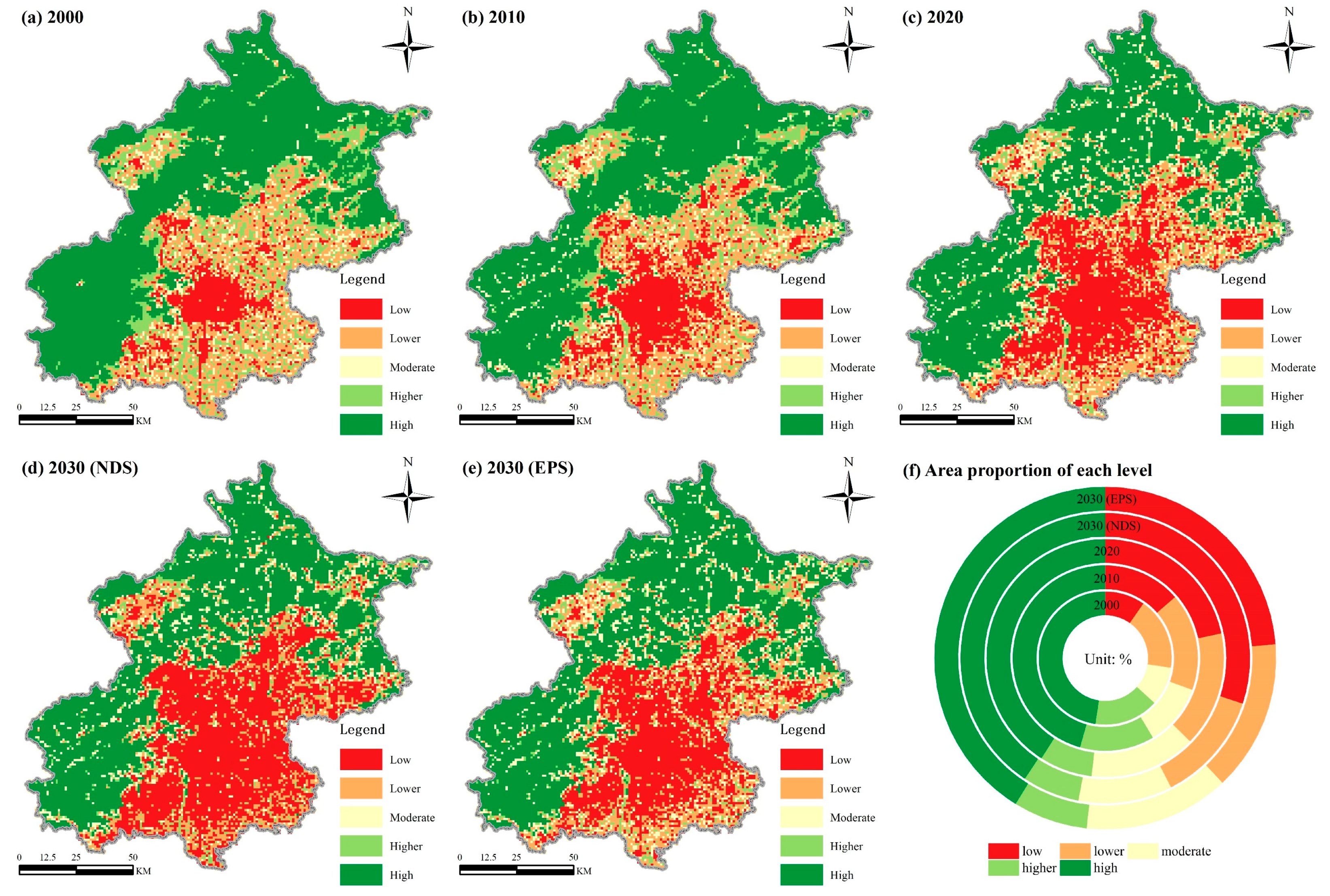
- Assessment of the spatial and temporal characteristics of UER change from 2000 to 2020 and under different scenarios in 2030.
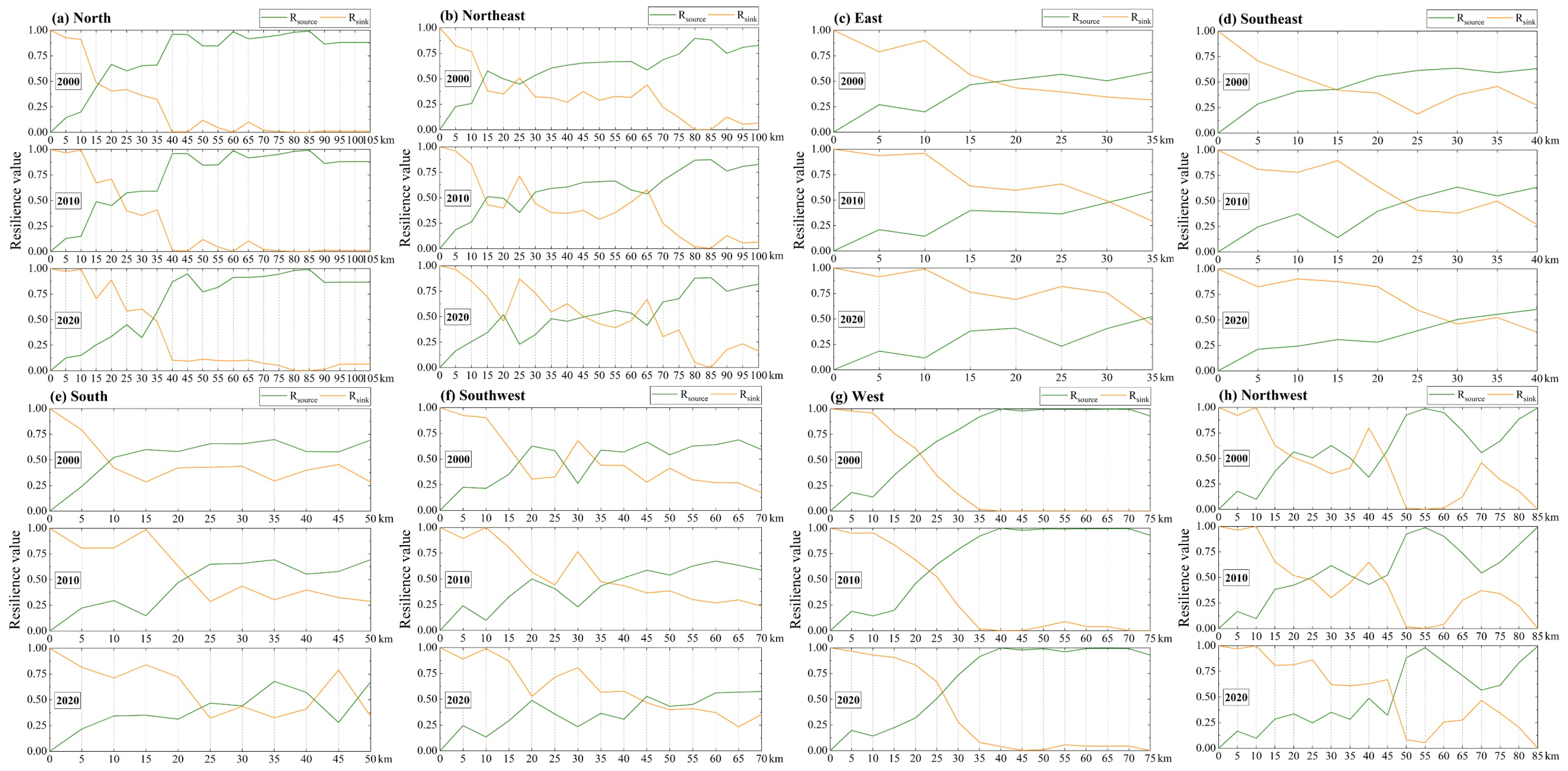
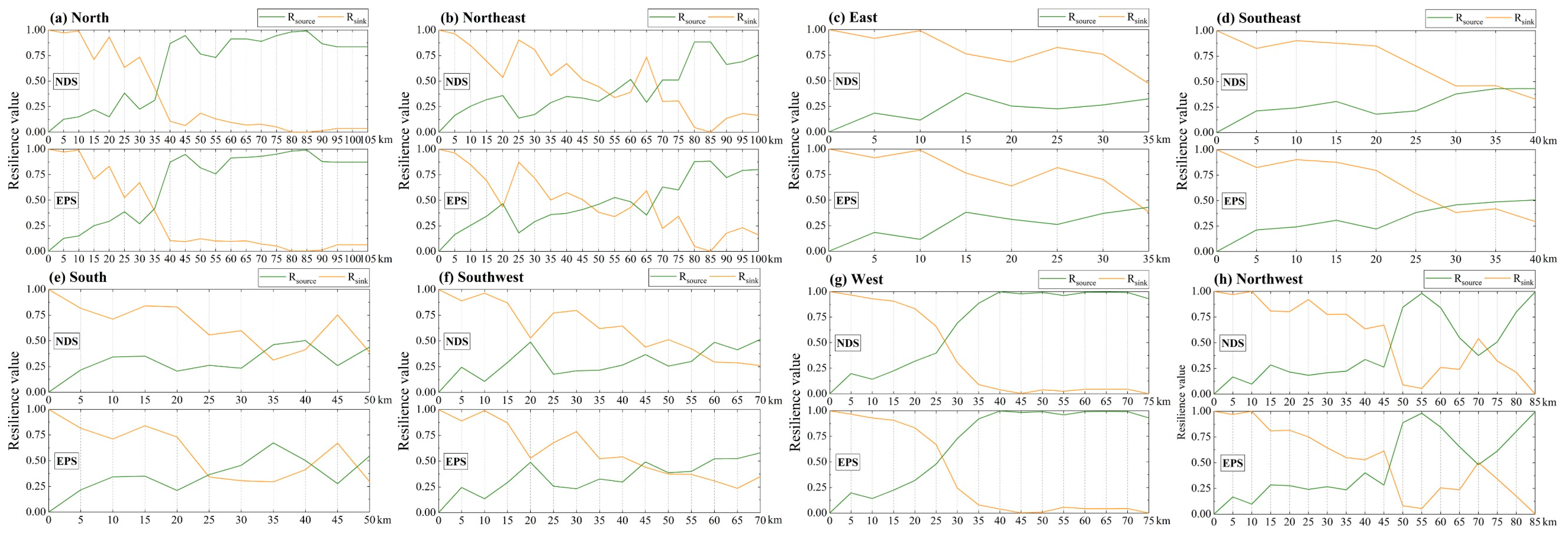
- Assessment of the change characteristics of UER-CDB from 2000 to 2020 and under different scenarios in 2030.
2. Materials and Methods
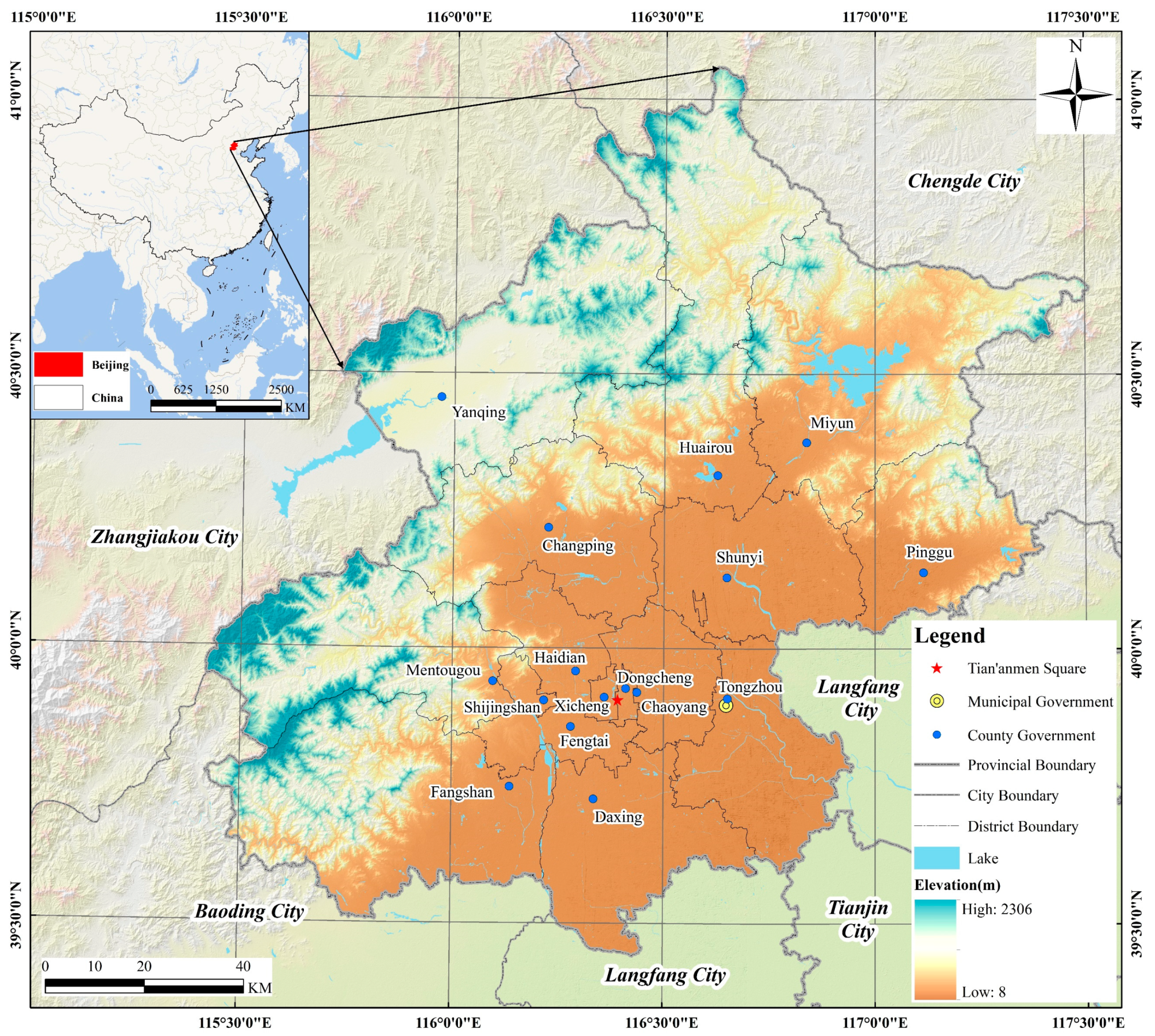
2.1. Study Area
2.2. Dataset and Preprocessing
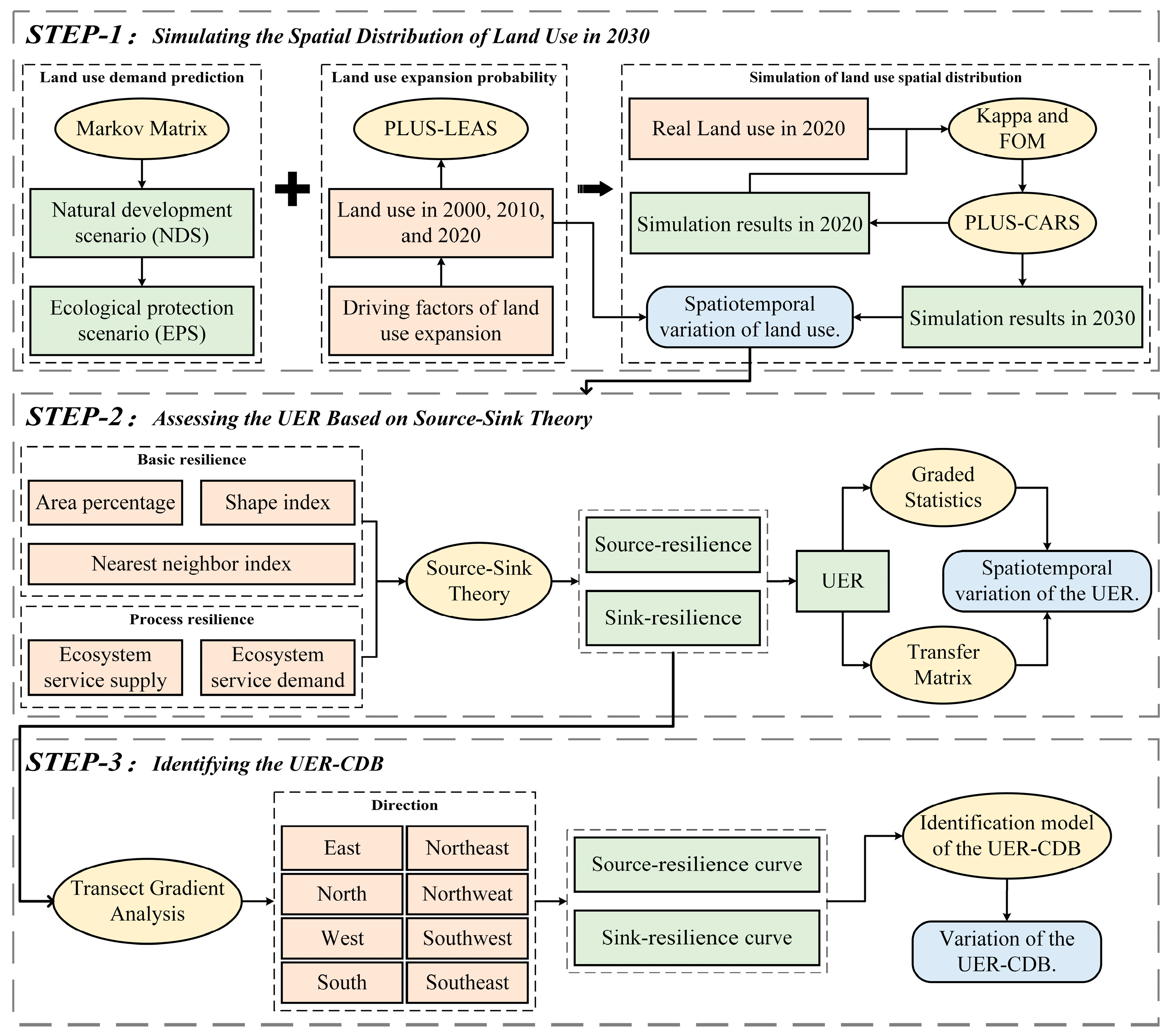
2.3. Technological Process
2.4. Simulating the Spatial Distribution of Land Use in 2030
2.4.1. Setting Development Scenarios and Predicting Land Use Demand
- (1)
- NDS
- (2)
- EPS
2.4.2. The PLUS Model and Accuracy Verification
2.5. Assessing UER Based on “Source-Sink” Theory
2.5.1. Basic Resilience
2.5.2. Process Resilience
2.5.3. Ecological Resilience
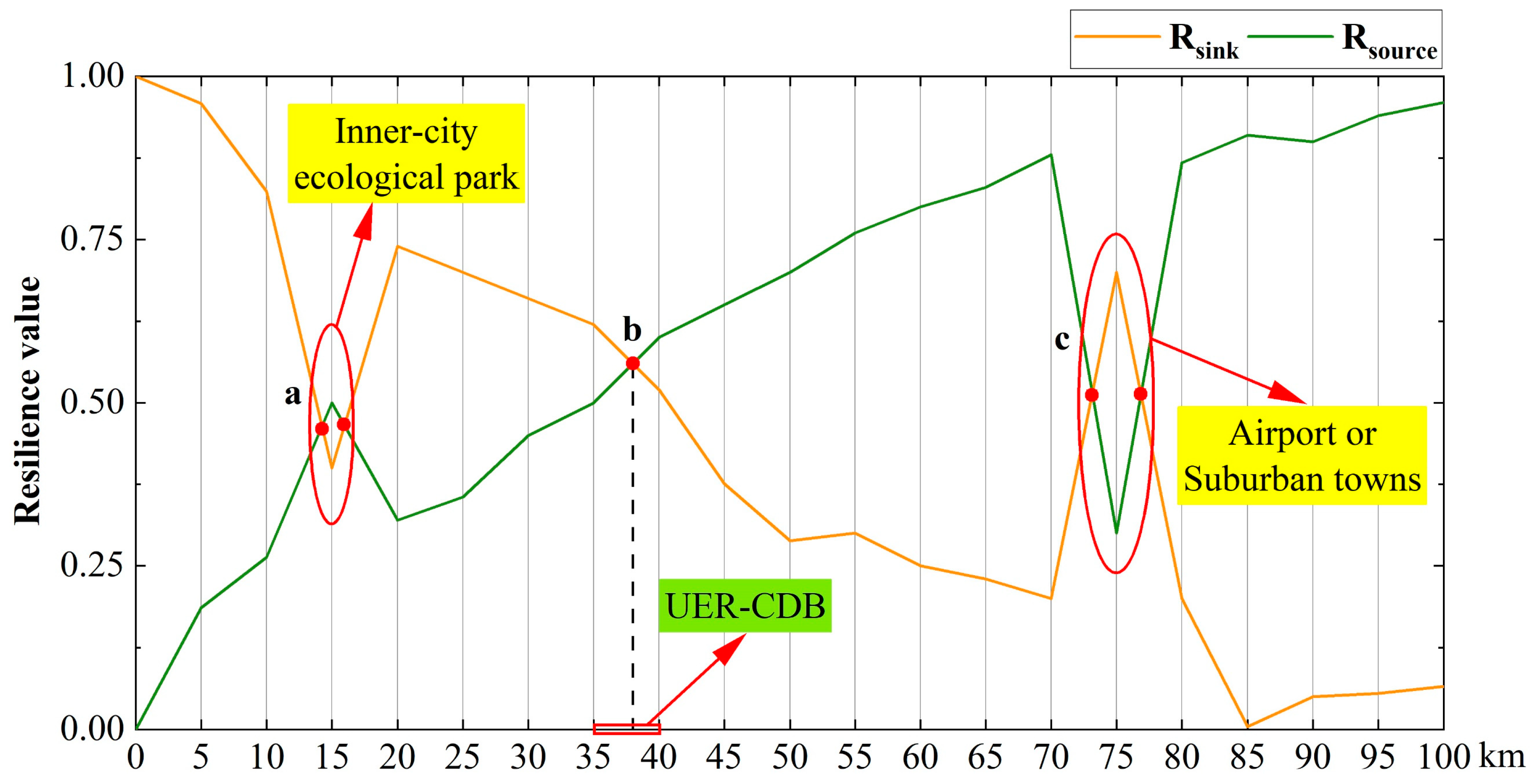
2.6. Identifying the UER-CDB
- The extension of the Beijing central axis as the north–south direction and the extension of Chang’an Street as the east–west direction, which are the significant development axes in Beijing’s urban planning.
- The intersection of Beijing’s central axis and Chang’an Street as the urban center, the extension of the connection line between the urban center and Miyun District Government as the northeast direction, and the extension of the connection line between the urban center and Yanqing District Government as the northwest direction. These two directions are located on the connection line between Beijing’s urban center and ecological cultured area, and are also essential areas for promoting the integrated development of urban and rural areas.
- The extension of the connection line between the urban center and Fangshan District Government as the southwest direction, and the extension of the connection line between the urban center and Yizhuang New Town (Yizhuang Town Government) as the southeast direction. These two directions are located on the “Beijing-Baoding-Shijiazhuang” development axis and the “Beijing-Tianjin” development axis, respectively, which are essential areas reflecting the coordinated development of the Beijing–Tianjin–Hebei region.
3. Results
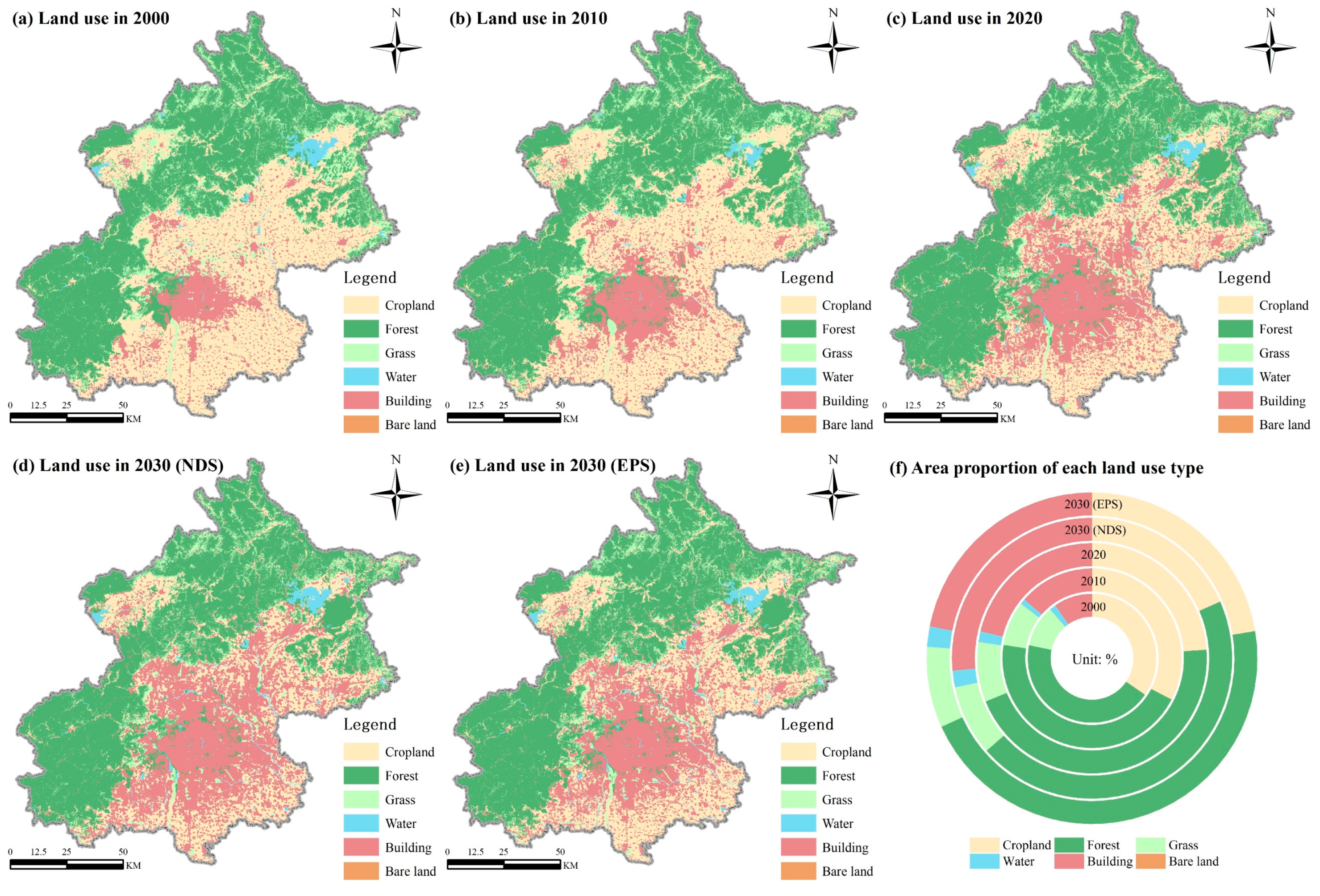
3.1. Analysis of Spatiotemporal Variation Characteristics of Land Use
3.2. Analysis of Spatiotemporal Variation Characteristics of UER
3.3. Analysis of Variation Characteristics of UER-CDB
4. Discussion
4.1. Implications of Spatiotemporal Variation Characteristics of Land Use
4.2. Impact of Urban Land Use on the UER
4.3. Differences of UER-CDB in Different Development Directions
4.4. Advantages and Limitations
5. Conclusions
- We demonstrate that the effective assessment of UER and quantitative identification of UER-CDB can be achieved by using the “source-sink” theory and the transect gradient method and successfully applying it in practice to historical periods and different development scenarios in the future. This study is an important complement to the methodological study on the assessment of UER and the identification of its critical thresholds.
- Over the past 20 years, land use in Beijing was dominated by forest, accounting for more than 40% of the total area, and this proportion has been showing an increasing trend. The encroachment of new buildings on cropland has been the main feature of land use change in Beijing, mainly in plain areas. In the next ten years, compared with the NDS, ecological spaces such as cropland, forest, grass, and water will be strictly protected under the EPS, and land expansion for the building will slow down.
- High and Higher UER areas in Beijing are mainly located in the western and northern mountainous areas, but the area share decreased from 63.26% to 48.15% from 2000 to 2020. In contrast, Low UER areas are mainly located in the building areas of the city, with an increased share of 11.94%. In the future, the EPS restrains the expansion of the building area, resulting in UER in Beijing in 2030 remaining stable compared with that in 2020.
- From 2000 to 2020, the changes in UER-CDB in Beijing in different development directions had obvious differences. Among them, the increase in the northeast, southwest, and northwest was more than 25 km. The changes were also obvious in the east and southeast due to the impact of policy planning. In the future, the UER-CDB will further increase under the NDS, while it remains basically the same as in 2020 under the EPS.
- Compared with the NDS, the EPS based on ecological protection policies is more in line with Beijing’s future urban development plans. It has proven to be both ecologically safe for the region and to improve the quality of cropland, which is more conducive to sustainable urban development.
Author Contributions
Funding
Data Availability Statement
Acknowledgments
Conflicts of Interest
References
- Thwala, W.D. The New Global Frontier: Urbanization, Poverty and Environment in the 21st Century. Dev. Pract. 2009, 19, 943–945. [Google Scholar] [CrossRef]
- Turner, V.K.; Kaplan, D.H. Geographic perspectives on urban sustainability: Past, current, and future research trajectories. Urban Geogr. 2019, 40, 267–278. [Google Scholar] [CrossRef]
- UN-Habitat. World Cities Report 2022: Envisaging the Future of Cities; United Nations Human Settlements Programme: Nairobi, Kenya, 2022. [Google Scholar]
- Krellenberg, K.; Bergsträßer, H.; Bykova, D.; Kress, N.; Tyndall, K. Urban Sustainability Strategies Guided by the SDGs—A Tale of Four Cities. Sustainability 2019, 11, 1116. [Google Scholar] [CrossRef]
- Zhou, M.; Ma, Y.; Tu, J.; Wang, M. SDG-oriented multi-scenario sustainable land-use simulation under the background of urban expansion. Environ. Sci. Pollut. Res. 2022, 29, 72797–72818. [Google Scholar] [CrossRef] [PubMed]
- Yang, M.; Jiao, M.; Zhang, J. Coupling Coordination and Interactive Response Analysis of Ecological Environment and Urban Resilience in the Yangtze River Economic Belt. Int. J. Environ. Res. Public Health 2022, 19, 11988. [Google Scholar] [CrossRef] [PubMed]
- Sterzel, T.; Lüdeke, M.K.B.; Walther, C.; Kok, M.T.; Sietz, D.; Lucas, P.L. Typology of coastal urban vulnerability under rapid urbanization. PLoS ONE 2020, 15, e0220936. [Google Scholar] [CrossRef] [PubMed]
- El-Hadidy, S.M. The relationship between urban heat islands and geological hazards in Mokattam plateau, Cairo, Egypt. Egypt. J. Remote Sens. Space Sci. 2021, 24, 547–557. [Google Scholar] [CrossRef]
- Zhang, W. Theoretical basis and methods of city health examination evaluation in China. Sci. Geogr. Sin. 2021, 41, 1687–1696. [Google Scholar] [CrossRef]
- Wang, T.; Zou, Z.; Zhou, G.; Zheng, J. A framework for measuring urban ecological resilience under high-quality development. J. Nat. Sci. Hunan Norm. Univ. 2022, 45, 8. Available online: https://kns.cnki.net/kcms/detail/43.1542.n.20220826.0841.002.html (accessed on 1 March 2023).
- Holling, C.S. Resilience and Stability of Ecological Systems. Annu. Rev. Ecol. Syst. 1973, 4, 1–23. [Google Scholar] [CrossRef]
- Meerow, S.; Newell, J.P. Urban resilience for whom, what, when, where, and why? Urban Geogr. 2016, 40, 309–329. [Google Scholar] [CrossRef]
- Motesharrei, S.; Rivas, J.; Kalnay, E.; Asrar, G.R.; Busalacchi, A.J.; Cahalan, R.F.; Cane, M.A.; Colwell, R.R.; Feng, K.; Franklin, R.S.; et al. Modeling sustainability: Population, inequality, consumption, and bidirectional coupling of the Earth and Human Systems. Natl. Sci. Rev. 2016, 3, 470–494. [Google Scholar] [CrossRef] [PubMed]
- Duo, L.; Li, Y.; Zhang, M.; Zhao, Y.; Wu, Z.; Zhao, D. Spatiotemporal Pattern Evolution of Urban Ecosystem Resilience Based on “Resistance-Adaptation-Vitality”: A Case Study of Nanchang City. Front. Earth Sci. 2022, 10, 902444. [Google Scholar] [CrossRef]
- Wilbanks, T.J.; Sathaye, J. Integrating mitigation and adaptation as responses to climate change: A synthesis. Mitig. Adapt. Strateg. Glob. Chang. 2007, 12, 957–962. [Google Scholar] [CrossRef]
- Zhang, X.; Li, H. Urban resilience and urban sustainability: What we know and what do not know? Cities 2018, 72, 141–148. [Google Scholar] [CrossRef]
- Zhao, R.; Fang, C.; Liu, H. Progress and prospect of urban resilience research. Prog. Geogr. 2020, 39, 1717–1731. [Google Scholar] [CrossRef]
- Zheng, Y.; Wang, W.; Pan, J. Low Carbon Resilient City: Concept, Approach and Policy Options. Urban Dev. Stud. 2013, 20, 10–14. [Google Scholar] [CrossRef]
- Tzoulas, K.; Korpela, K.; Venn, S.; Yli-Pelkonen, V.; Kaźmierczak, A.; Niemela, J.; James, P. Promoting ecosystem and human health in urban areas using Green Infrastructure: A literature review. Landsc. Urban Plan. 2007, 81, 167–178. [Google Scholar] [CrossRef]
- Chen, S.; Yuan, Q. Urban Ecosphere Structure and Its Resilience Evolution: Theoretical Framework and Empirical Analysis of Guangzhou. Planners 2017, 33, 25–30. Available online: https://kns.cnki.net/kcms/detail/detail.aspx?FileName=GHSI201708003&DbName=CJFQ2017 (accessed on 1 March 2023).
- Wang, S.; Cui, Z.; Lin, J.; Xie, J.; Su, K. The coupling relationship between urbanization and ecological resilience in the Pearl River Delta. J. Geogr. Sci. 2022, 32, 44–64. [Google Scholar] [CrossRef]
- Wu, X.; Zhang, J.; Geng, X.; Wang, T.; Wang, K.; Liu, S. Increasing green infrastructure-based ecological resilience in urban systems: A perspective from locating ecological and disturbance sources in a resource-based city. Sustain. Cities Soc. 2020, 61, 102354. [Google Scholar] [CrossRef]
- Chen, L.; Fu, B.; Zhao, W. Source-sink landscape theory and its ecological significance. Front. Biol. China 2008, 3, 131–136. [Google Scholar] [CrossRef]
- Bak, P.; Chen, K. Self-Organized Criticality. Sci. Am. 1991, 264, 46–53. [Google Scholar] [CrossRef]
- Li, J.; Sun, C.; Zheng, X. Assessment of spatio-temporal evolution of regionally ecological risks based on adaptive cycle theory: A case study of Yangtze River Delta urban agglomeration. Acta Ecol. Sin. 2021, 41, 2609–2621. [Google Scholar] [CrossRef]
- Sherrieb, K.; Norris, F.H.; Galea, S. Measuring Capacities for Community Resilience. Soc. Indic. Res. 2010, 99, 227–247. [Google Scholar] [CrossRef]
- Gunderson, L.H.; Holling, C.S. Panarchy: Understanding Transformations in Human and Natural Systems; Island Press: Washington, DC, USA, 2001. [Google Scholar]
- Wang, S.; Yun, Y.; Jia, Q. Ecological Resilience Evaluation of Central Urban Area of Tianjin Based on“Source-Flow-Sink”Index Analysis. J. Hum. Settl. West China 2020, 35, 82–90. [Google Scholar] [CrossRef]
- Chen, Y.; Wang, J.; Xiong, N.; Sun, L.; Xu, J. Impacts of Land Use Changes on Net Primary Productivity in Urban Agglomerations under Multi-Scenarios Simulation. Remote Sens. 2022, 14, 1755. [Google Scholar] [CrossRef]
- Xie, H.; Tong, X.; Meng, W.; Liang, D.; Wang, Z.; Shi, W. A Multilevel Stratified Spatial Sampling Approach for the Quality Assessment of Remote-Sensing-Derived Products. IEEE J. Sel. Top. Appl. Earth Obs. Remote Sens. 2015, 8, 4699–4713. [Google Scholar] [CrossRef]
- Chen, F.; Chen, J.; Wu, H.; Hou, D.; Zhang, W.; Zhang, J.; Zhou, X.; Chen, L. A landscape shape index-based sampling approach for land cover accuracy assessment. Sci. China Earth Sci. 2016, 59, 2263–2274. [Google Scholar] [CrossRef]
- Jun, C.; Ban, Y.; Li, S. Open access to Earth land-cover map. Nature 2014, 514, 434. [Google Scholar] [CrossRef]
- Xia, C.; Dong, Z.; Chen, B. Spatio-temporal analysis and simulation of urban ecological resilience: A Case Study of Hangzhou. Acta Ecol. Sin. 2022, 42, 116–126. [Google Scholar] [CrossRef]
- Gao, L.; Tao, F.; Liu, R.; Wang, Z.; Leng, H.; Zhou, T. Multi-scenario simulation and ecological risk analysis of land use based on the PLUS model: A case study of Nanjing. Sustain. Cities Soc. 2022, 85, 104055. [Google Scholar] [CrossRef]
- Wang, Z.; Zeng, J.; Chen, W. Impact of urban expansion on carbon storage under multi-scenario simulations in Wuhan, China. Environ. Sci. Pollut. Res. 2022, 29, 45507–45526. [Google Scholar] [CrossRef] [PubMed]
- Zhou, L.; Dang, X.; Sun, Q.; Wang, S. Multi-scenario simulation of urban land change in Shanghai by random forest and CA-Markov model. Sustain. Cities Soc. 2020, 55, 102045. [Google Scholar] [CrossRef]
- Liang, X.; Guan, Q.; Clarke, K.C.; Liu, S.; Wang, B.; Yao, Y. Understanding the drivers of sustainable land expansion using a patch-generating land use simulation (PLUS) model: A case study in Wuhan, China. Comput. Environ. Urban Syst. 2021, 85, 101569. [Google Scholar] [CrossRef]
- Wang, Z.; Li, X.; Mao, Y.; Li, L.; Wang, X.; Lin, Q. Dynamic simulation of land use change and assessment of carbon storage based on climate change scenarios at the city level: A case study of Bortala, China. Ecol. Indic. 2022, 134, 108499. [Google Scholar] [CrossRef]
- Zhai, H.; Lv, C.; Liu, W.; Yang, C.; Fan, D.; Wang, Z.; Guan, Q. Understanding Spatio-Temporal Patterns of Land Use/Land Cover Change under Urbanization in Wuhan, China, 2000–2019. Remote Sens. 2021, 13, 3331. [Google Scholar] [CrossRef]
- Zhang, X.; Wang, J.; Yue, C.; Ma, S.; Wang, L.-J. Exploring the spatiotemporal changes in carbon storage under different development scenarios in Jiangsu Province, China. PeerJ 2022, 10, e13411. [Google Scholar] [CrossRef]
- Zhu, K.; He, J.; Zhang, L.; Song, D.; Wu, L.; Liu, Y.; Zhang, S. Impact of Future Development Scenario Selection on Landscape Ecological Risk in the Chengdu-Chongqing Economic Zone. Land 2022, 11, 964. [Google Scholar] [CrossRef]
- Pontius, R.G.; Boersma, W.; Castella, J.-C.; Clarke, K.; de Nijs, T.; Dietzel, C.; Duan, Z.; Fotsing, E.; Goldstein, N.; Kok, K.; et al. Comparing the input, output, and validation maps for several models of land change. Ann. Reg. Sci. 2008, 42, 11–37. [Google Scholar] [CrossRef]
- Pontius, R.G.; Peethambaram, S.; Castella, J.-C. Comparison of Three Maps at Multiple Resolutions: A Case Study of Land Change Simulation in Cho Don District, Vietnam. Ann. Assoc. Am. Geogr. 2011, 101, 45–62. [Google Scholar] [CrossRef]
- Chen, Y.; Li, X.; Liu, X.; Ai, B. Modeling urban land-use dynamics in a fast developing city using the modified logistic cellular automaton with a patch-based simulation strategy. Int. J. Geogr. Inf. Sci. 2014, 28, 234–255. [Google Scholar] [CrossRef]
- Feng, X.; Xiu, C.; Bai, L.; Zhong, Y.; Wei, Y. Comprehensive evaluation of urban resilience based on the perspective of landscape pattern: A case study of Shenyang city. Cities 2020, 104, 102722. [Google Scholar] [CrossRef]
- Huang, Z.; Wang, F.; Cao, W. Dynamic analysis of an ecological security pattern relying on the relationship between ecosystem service supply and demand: A case study on the Xiamen-Zhangzhou-Quanzhou city cluster. Acta Ecol. Sin. 2018, 38, 4327–4340. [Google Scholar] [CrossRef]
- Li, S.; Liu, H. Spatio-temporal pattern evolution of coupling coordination between urbanization and ecological resilience in arid region: A case of Ningxia Hui Autonomous Region. Arid. Land Geogr. 2022, 45, 1281–1290. [Google Scholar] [CrossRef]
- Li, Z.; Hu, B.; Ren, Y. The Supply–Demand Budgets of Ecosystem Service Response to Urbanization: Insights from Urban–Rural Gradient and Major Function-Oriented Areas. Remote Sens. 2022, 14, 5670. [Google Scholar] [CrossRef]
- Burkhard, B.; Kroll, F.; Müller, F.; Windhorst, W. Landscapes’ capacities to provide ecosystem services—A concept for land-cover based assessments. Landsc. Online 2009, 15, 1–22. [Google Scholar] [CrossRef]
- Wu, A.; Zhang, J.; Zhao, Y.; Shen, H.; Guo, X. Simulation and Optimization of Supply and Demand Pattern of Multiobjective Ecosystem Services—A Case Study of the Beijing-Tianjin-Hebei Region. Sustainability 2022, 14, 2658. [Google Scholar] [CrossRef]
- Luck, M.; Wu, J. A gradient analysis of urban landscape pattern: A case study from the Phoenix metropolitan region, Arizona, USA. Landsc. Ecol. 2002, 71, 1232–1237. [Google Scholar] [CrossRef]
- Cui, W.; Li, Y.; Li, X. Gradient Analysis and Comparison of Landscape Pattern along Different Transects in the Main Urban Area of Chongqing City. J. Nat. Resour. 2017, 32, 553–567. [Google Scholar] [CrossRef]
- Huang, N.; Lin, T.; Zhang, W.; Cao, Y. Gradient Analysis and Comparison of Landscape Pattern along Different Expansion Axes of Tong’an District in Xiamen City. Prog. Geogr. 2009, 28, 767–774. [Google Scholar] [CrossRef]
- Zhang, J.; Wu, Z.; Lv, Z.; Gao, Y. Extent effect of landscape gradient analysis of urban-rural transect. Chin. J. Ecol. 2008, 27, 978–984. [Google Scholar] [CrossRef]
- Wang, J.; Zhang, J.; Xiong, N.; Liang, B.; Wang, Z.; Cressey, E.L. Spatial and Temporal Variation, Simulation and Prediction of Land Use in Ecological Conservation Area of Western Beijing. Remote Sens. 2022, 14, 1452. [Google Scholar] [CrossRef]
- Zhang, P.; Shao, G.; Zhao, G.; Le Master, D.C.; Parker, G.R.; Dunning, J.B.; Li, Q. China’s Forest Policy for the 21st Century. Science 2000, 288, 2135–2136. [Google Scholar] [CrossRef]
- Liu, B.; Qian, J.; Zhao, R.; Yang, Q.; Wu, K.; Zhao, H.; Feng, Z.; Dong, J. Spatio-Temporal Variation and Its Driving Forces of Soil Organic Carbon along an Urban–Rural Gradient: A Case Study of Beijing. Int. J. Environ. Res. Public Health 2022, 19, 15201. [Google Scholar] [CrossRef]
- Zhao, X.; Zhang, Z.; Wang, X.; Zuo, L.; Liu, B.; Yi, L.; Xu, J.; Wen, Q. Analysis of Chinese cultivated land′s spatial-temporal changes and causes in recent 30 years. Trans. Chin. Soc. Agric. Eng. 2014, 30, 1–11. [Google Scholar] [CrossRef]
- Chu, M.; Lu, J.; Sun, D. Influence of Urban Agglomeration Expansion on Fragmentation of Green Space: A Case Study of Beijing-Tianjin-Hebei Urban Agglomeration. Land 2022, 11, 275. [Google Scholar] [CrossRef]
- Naeem, S.; Cao, C.; Fatima, K.; Najmuddin, O.; Acharya, B.K. Landscape Greening Policies-based Land Use/Land Cover Simulation for Beijing and Islamabad—An Implication of Sustainable Urban Ecosystems. Sustainability 2018, 10, 1049. [Google Scholar] [CrossRef]
- Dadashpoor, H.; Azizi, P.; Moghadasi, M. Land use change, urbanization, and change in landscape pattern in a metropolitan area. Sci. Total Environ. 2019, 655, 707–719. [Google Scholar] [CrossRef]
- Li, J.; Dong, S.; Li, Y.; Wang, Y.; Li, Z.; Li, F. Effects of land use change on ecosystem services in the China–Mongolia–Russia economic corridor. J. Clean. Prod. 2022, 360, 132175. [Google Scholar] [CrossRef]
- Li, H.; Peng, J.; Yanxu, L.; Yi’na, H. Urbanization impact on landscape patterns in Beijing City, China: A spatial heterogeneity perspective. Ecol. Indic. 2017, 82, 50–60. [Google Scholar] [CrossRef]
- Xie, W.; Huang, Q.; He, C.; Zhao, X. Projecting the impacts of urban expansion on simultaneous losses of ecosystem services: A case study in Beijing, China. Ecol. Indic. 2018, 84, 183–193. [Google Scholar] [CrossRef]
- Wang, Y.; Huang, H.; Yang, G.; Chen, W. Ecosystem Service Function Supply–Demand Evaluation of Urban Functional Green Space Based on Multi-Source Data Fusion. Remote Sens. 2023, 15, 118. [Google Scholar] [CrossRef]
- Shi, C.; Zhu, X.; Wu, H.; Li, Z. Assessment of Urban Ecological Resilience and Its Influencing Factors: A Case Study of the Beijing-Tianjin-Hebei Urban Agglomeration of China. Land 2022, 11, 921. [Google Scholar] [CrossRef]
- Huang, L.; Wang, J.; Cheng, H. Spatiotemporal changes in ecological network resilience in the Shandong Peninsula urban agglomeration. J. Clean. Prod. 2022, 339, 130681. [Google Scholar] [CrossRef]
- Seto, K.C.; Güneralp, B.; Hutyra, L.R. Global forecasts of urban expansion to 2030 and direct impacts on biodiversity and carbon pools. Proc. Natl. Acad. Sci. USA 2012, 109, 16083–16088. [Google Scholar] [CrossRef] [PubMed]
- Delphin, S.; Escobedo, F.J.; Abd-Elrahman, A.; Cropper, W.P. Urbanization as a land use change driver of forest ecosystem services. Land Use Policy 2016, 54, 188–199. [Google Scholar] [CrossRef]
- Qiu, J.; Wang, X.; Lu, F.; Ouyang, Z.; Zheng, H. The spatial pattern of landscape fragmentation and its relations with urbanization and socio-economic developments: A case study of Beijing. Acta Ecol. Sin. 2012, 32, 2659–2669. [Google Scholar] [CrossRef]
- Chen, X.; Zeng, X.; Zhao, C.; Qiu, R.; Zhang, L.; Hou, X.; Hu, X. The ecological effect of road network based on remote sensing ecological index: A case study of Fuzhou City, Fujian Province. Acta Ecol. Sin. 2021, 41, 4732–4745. [Google Scholar] [CrossRef]
- Hu, Y.; Zheng, Y.; Zheng, X. Simulation of land-use scenarios for Beijing using CLUE-S and Markov composite models. Chin. Geogr. Sci. 2013, 23, 92–100. [Google Scholar] [CrossRef]
- Su, R.; Cao, Y.; Wang, W.; Qiu, M.; Song, L. Analysis of spatiotemporal characteristics of cultivated land use change from 2001 to 2017 in the Chaobai River basin of the Beijing-Tianjin-Hebei region. J. Agric. Resour. Environ. 2020, 37, 574–582. [Google Scholar] [CrossRef]
- Qing, F.; Peng, Y. Development and optimization of ecological network of Shunyi District of Beijing based on RS and GIS. Chin. J. Appl. Environ. Biol. 2016, 22, 1074–1081. Available online: https://kns.cnki.net/kcms2/article/abstract?v=3uoqIhG8C44YLTlOAiTRKibYlV5Vjs7iAEhECQAQ9aTiC5BjCgn0Rk2q2Ixd8lVJsMmFoiDkk6yumZCJu3KtRVuoL5avyWA5&uniplatform=NZKPT (accessed on 1 March 2023).
- Liu, Y.; Shi, J.; Zheng, Y.; Huang, X. The Evolution Pattern and Simulation of Land Use in the Beijing Municipal Administrative Center (Tongzhou District). J. Resour. Ecol. 2022, 13, 270–284. [Google Scholar] [CrossRef]
- Wang, J.; Hu, Y.; Song, R.; Wang, W. Research on the Optimal Allocation of Ecological Land from the Perspective of Human Needs—Taking Hechi City, Guangxi as an Example. Int. J. Environ. Res. Public Health 2022, 19, 12418. [Google Scholar] [CrossRef]

| Category | Data | Resolution | Data Resource |
|---|---|---|---|
| Socioeconomic driver data | GDP | 1 km | https://www.resdc.cn, accessed on 1 August 2022 |
| Population density | 100 m | https://hub.worldpop.org/, accessed on 1 August 2022 | |
| Nighttime lights | 500 m | https://eogdata.mines.edu/products/vnl/, accessed on 1 August 2022 | |
| Road network | Ministry of Natural Resources of China | ||
| Governments point | Ministry of Natural Resources of China | ||
| Nature and climatic driver | DEM | 30 m | ASTER GDEM 30 M dataset http://www.gscloud.cn, accessed on 1 August 2022 |
| Temperature | 1 km | http://www.geodata.cn, accessed on 1 August 2022 | |
| Precipitation | 1 km | http://www.geodata.cn, accessed on 1 August 2022 | |
| River system | 2 m | Ministry of Natural Resources of China |
| Level | Low | Lower | Moderate | Higher | High | Total 2000 |
|---|---|---|---|---|---|---|
| Low | 1445.59 | 125.45 | 23.16 | 2.89 | 0.00 | 1597.09 |
| Lower | 1219.77 | 1203.37 | 414.96 | 45.36 | 2.89 | 2886.35 |
| Moderate | 447.76 | 358.98 | 689.99 | 41.49 | 6.76 | 1544.98 |
| Higher | 410.13 | 744.99 | 465.13 | 822.19 | 127.38 | 2569.82 |
| High | 32.81 | 138.00 | 788.41 | 271.17 | 6581.37 | 7811.76 |
| Total 2020 | 3556.06 | 2570.79 | 2381.65 | 1183.10 | 6718.40 | 16,410.00 |
| Level | Low | Lower | Moderate | Higher | High | Total 2020 |
|---|---|---|---|---|---|---|
| Low | 3485.61 | 68.52 | 1.93 | 0.00 | 0.00 | 3556.06 |
| Lower | 1166.70 | 1167.66 | 220.02 | 16.41 | 0.00 | 2570.79 |
| Moderate | 284.68 | 712.18 | 1225.56 | 132.21 | 27.02 | 2381.65 |
| Higher | 0.97 | 87.81 | 205.55 | 863.68 | 25.09 | 1183.10 |
| High | 0.00 | 0.97 | 64.65 | 39.56 | 6613.22 | 6718.40 |
| Total 2030 (NDS) | 4937.96 | 2037.14 | 1717.71 | 1051.86 | 6665.33 | 16,410.00 |
| Low | 3443.16 | 111.94 | 0.96 | 0.00 | 0.00 | 3556.06 |
| Lower | 441.02 | 1867.29 | 250.90 | 11.58 | 0.00 | 2570.79 |
| Moderate | 8.69 | 353.19 | 1943.53 | 70.45 | 5.79 | 2381.65 |
| Higher | 0.00 | 6.74 | 49.22 | 1072.13 | 55.01 | 1183.10 |
| High | 0.00 | 0.00 | 12.55 | 4.82 | 6701.03 | 6718.40 |
| Total 2030 (EPS) | 3892.85 | 2339.18 | 2257.16 | 1158.98 | 6761.83 | 16,410.00 |
| Direction | 2000 | 2010 | 2020 | 2030 (NDS) | 2030 (EPS) |
|---|---|---|---|---|---|
| North | 15–20 | 20–25 | 30–35 | 35–40 | 30–35 |
| Northeast | 10–15 | 10–15 | 45–50 | 50–55 | 45–50 |
| East | 15–20 | 30–35 | 30–35 | — | 30–35 |
| Southeast | 10–15 | 20–25 | 25–30 | 35–40 | 25–30 |
| South | 5–10 | 20–25 | 20–25 | 30–35 | 20–25 |
| Southwest | 15–20 | 35–40 | 40–45 | 55–60 | 40–45 |
| West | 20–25 | 20–25 | 25–30 | 25–30 | 25–30 |
| Northwest | 15–20 | 20–25 | 45–50 | 45–50 | 45–50 |
Disclaimer/Publisher’s Note: The statements, opinions and data contained in all publications are solely those of the individual author(s) and contributor(s) and not of MDPI and/or the editor(s). MDPI and/or the editor(s) disclaim responsibility for any injury to people or property resulting from any ideas, methods, instructions or products referred to in the content. |
© 2023 by the authors. Licensee MDPI, Basel, Switzerland. This article is an open access article distributed under the terms and conditions of the Creative Commons Attribution (CC BY) license (https://creativecommons.org/licenses/by/4.0/).
Share and Cite
Ning, X.; Zhang, X.; Zhang, X.; Wang, H.; Zhang, W. A Method for Assessing Urban Ecological Resilience and Identifying Its Critical Distance Belt Based on the “Source-Sink” Theory: A Case Study of Beijing. Remote Sens. 2023, 15, 2502. https://doi.org/10.3390/rs15102502
Ning X, Zhang X, Zhang X, Wang H, Zhang W. A Method for Assessing Urban Ecological Resilience and Identifying Its Critical Distance Belt Based on the “Source-Sink” Theory: A Case Study of Beijing. Remote Sensing. 2023; 15(10):2502. https://doi.org/10.3390/rs15102502
Chicago/Turabian StyleNing, Xiaogang, Xiaoyuan Zhang, Xiaoyu Zhang, Hao Wang, and Weiwei Zhang. 2023. "A Method for Assessing Urban Ecological Resilience and Identifying Its Critical Distance Belt Based on the “Source-Sink” Theory: A Case Study of Beijing" Remote Sensing 15, no. 10: 2502. https://doi.org/10.3390/rs15102502
APA StyleNing, X., Zhang, X., Zhang, X., Wang, H., & Zhang, W. (2023). A Method for Assessing Urban Ecological Resilience and Identifying Its Critical Distance Belt Based on the “Source-Sink” Theory: A Case Study of Beijing. Remote Sensing, 15(10), 2502. https://doi.org/10.3390/rs15102502


