
Analysis of GNSS-Derived Tropospheric Zenith Non-Hydrostatic Delay Anomaly during Sandstorms in Northern China on 15th March 2021


Abstract
1. Introduction
2. Materials and Methods
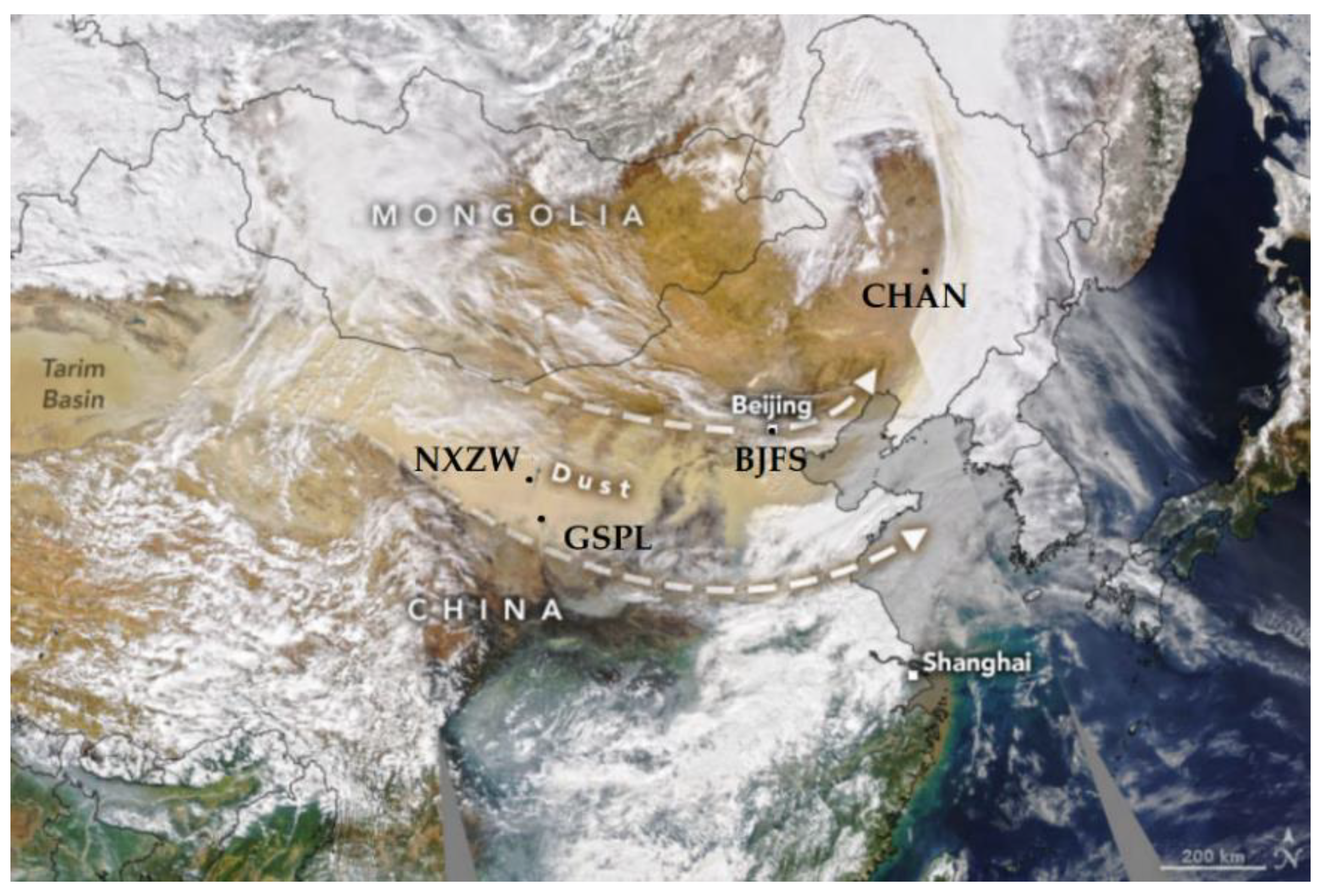
2.1. Materials
2.2. Methodology
2.2.1. PWV Inversion Based on GNSS Data
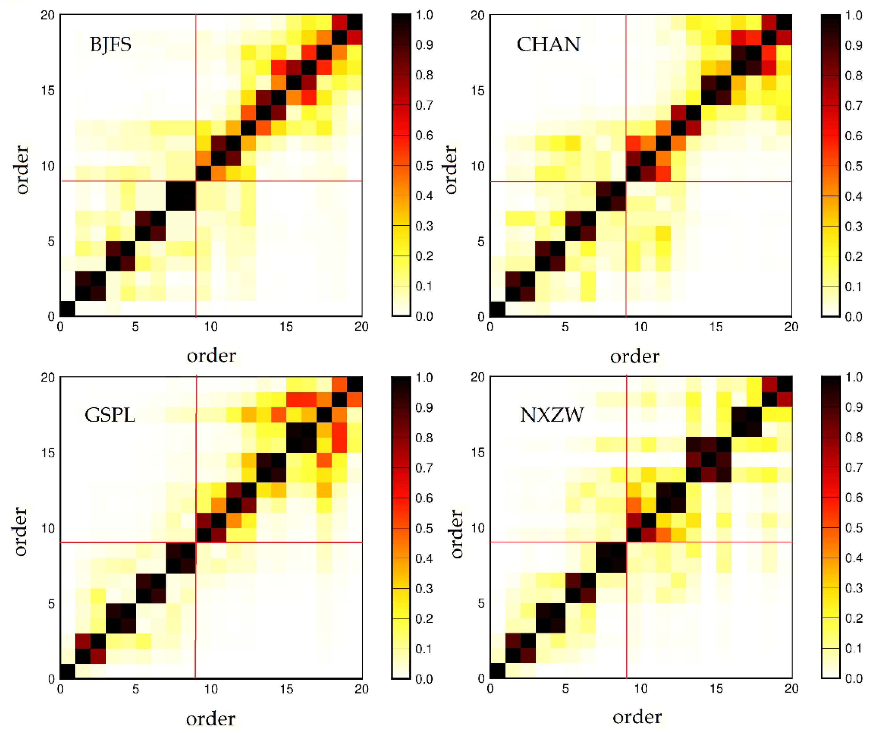
2.2.2. Singular Spectrum Analysis
3. Results and Discussion
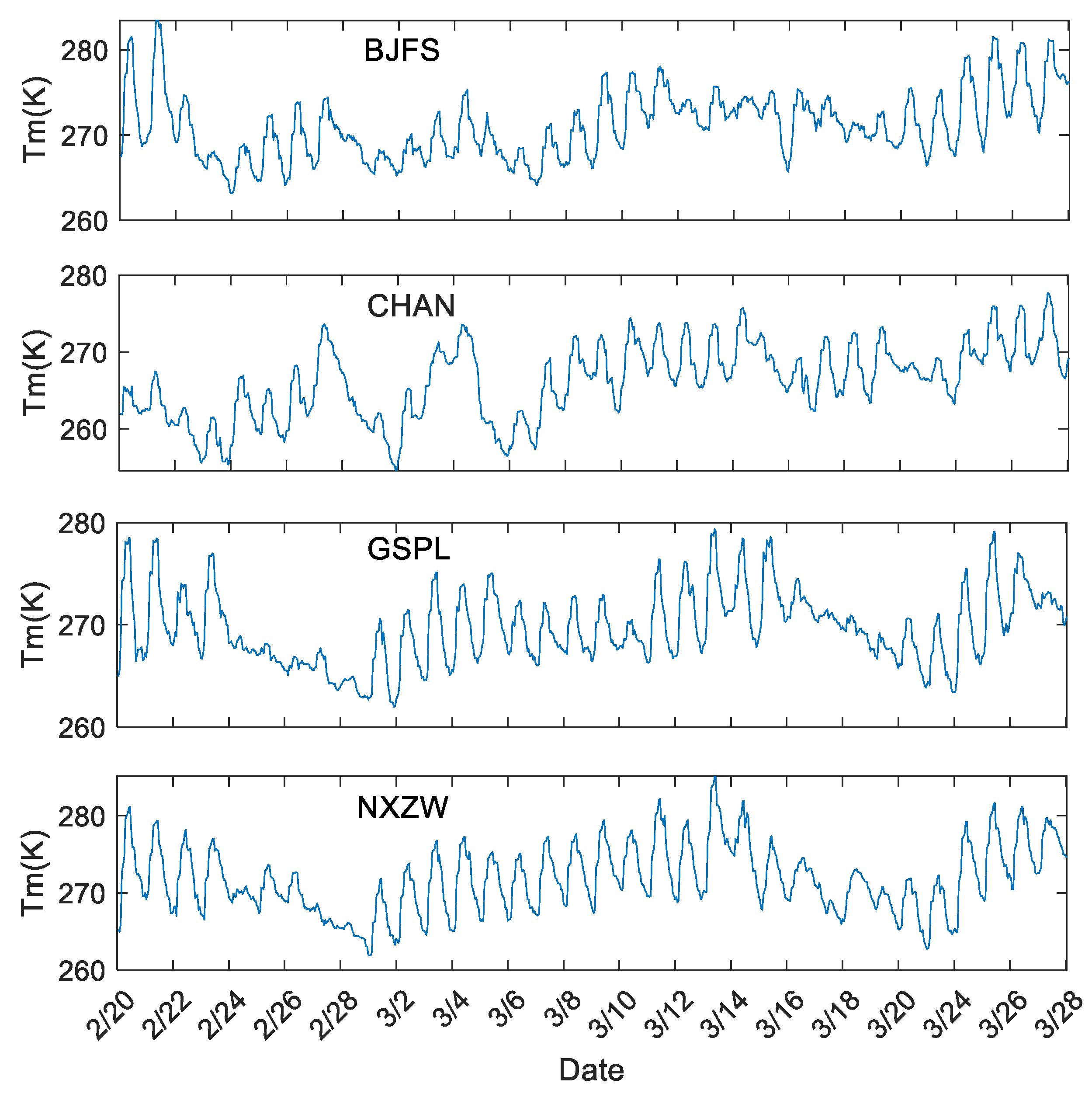
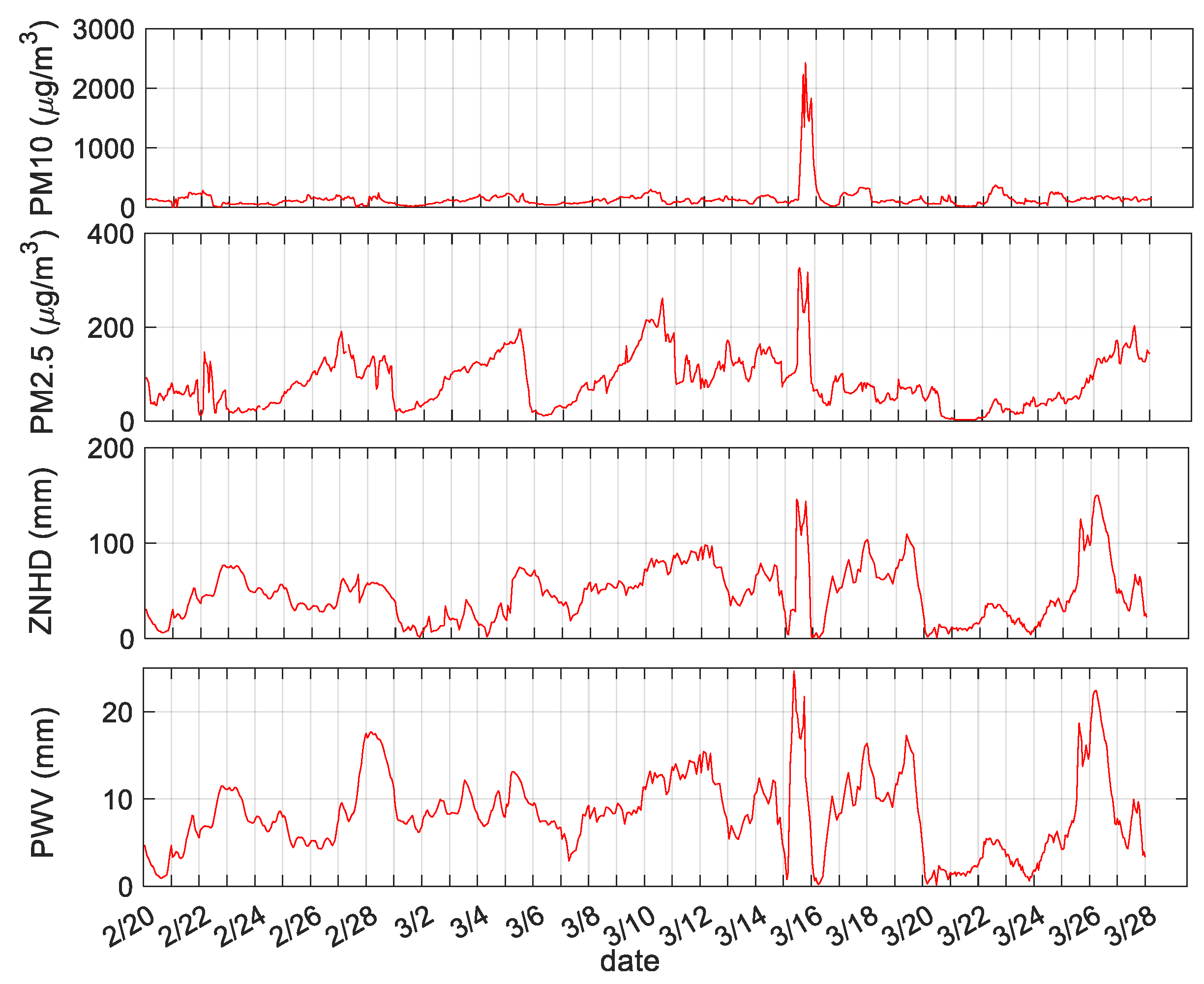
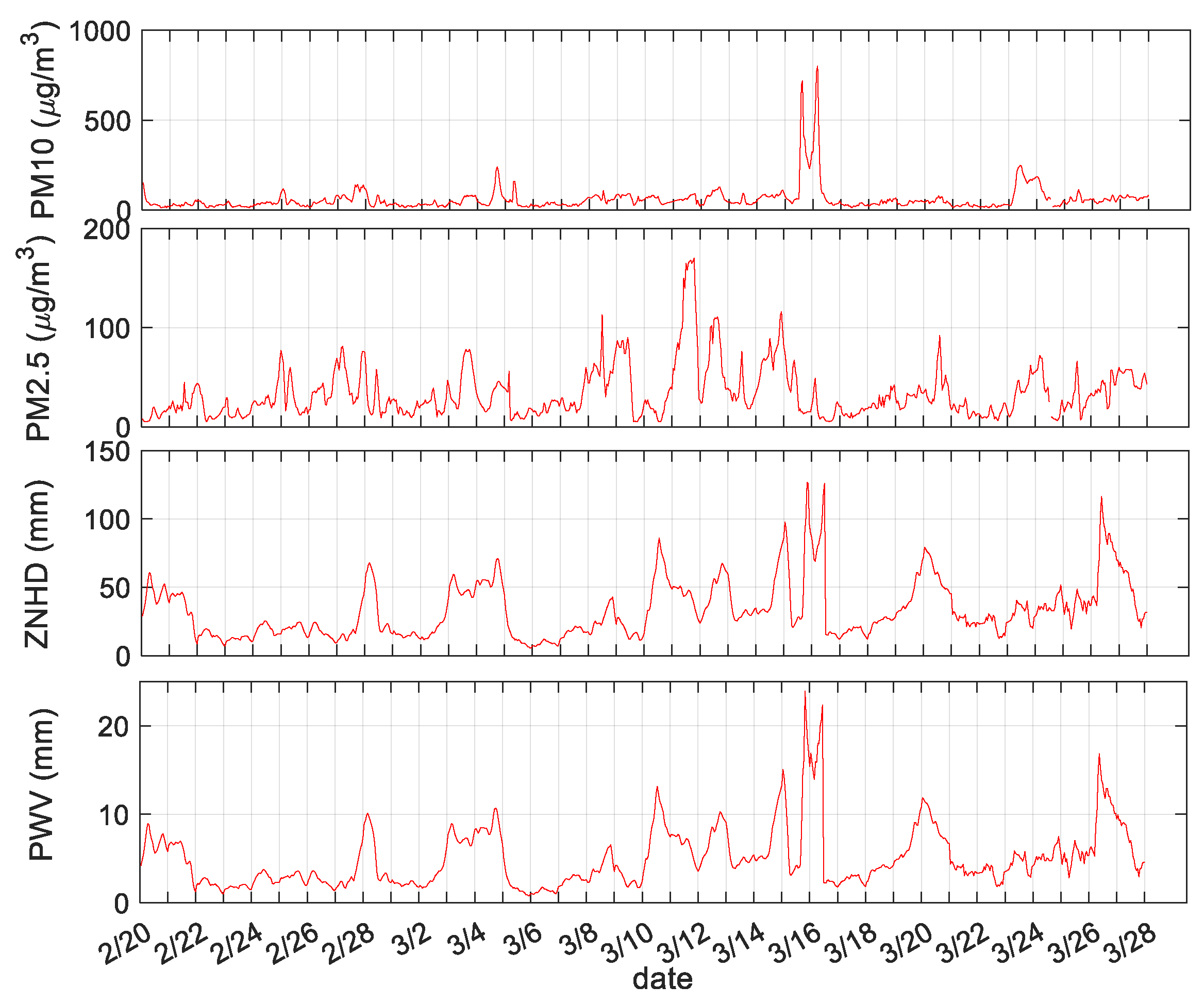
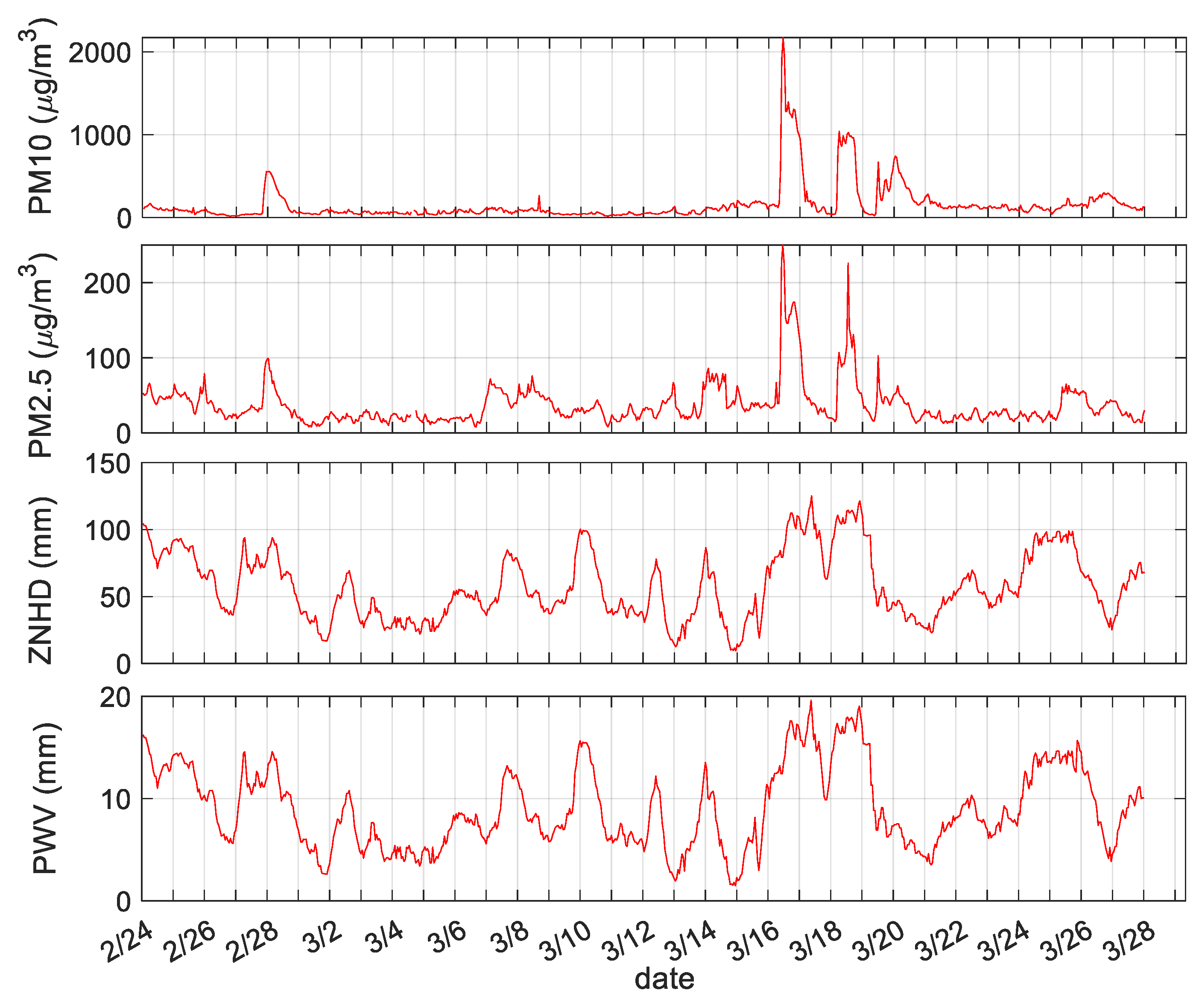
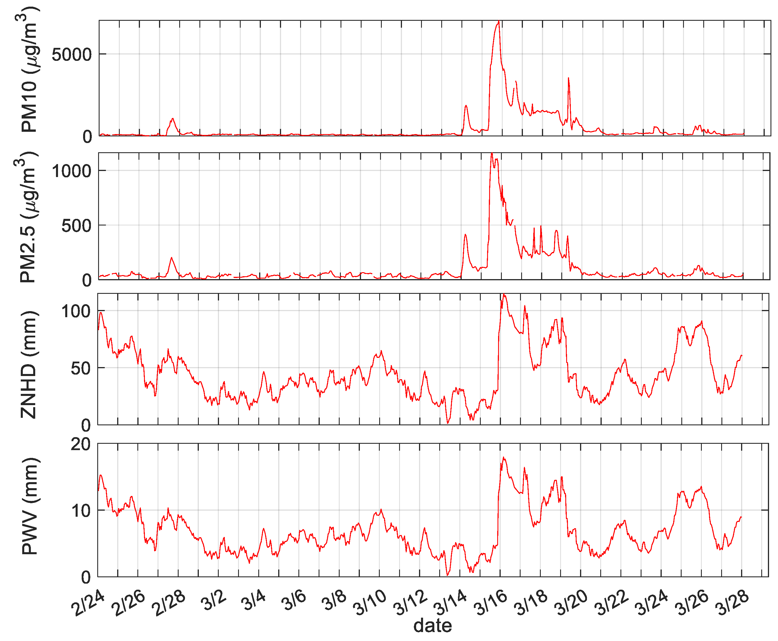
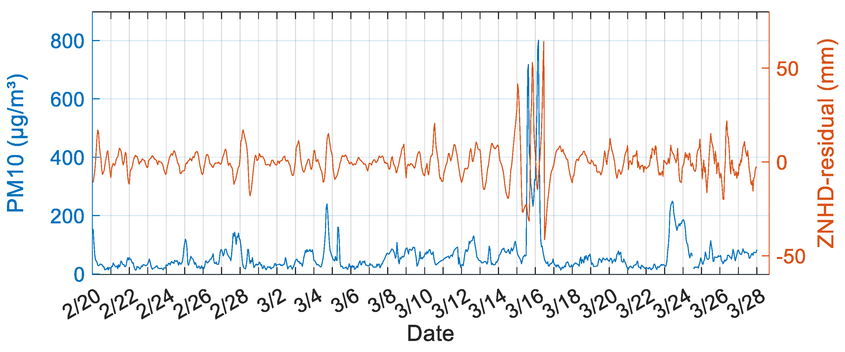
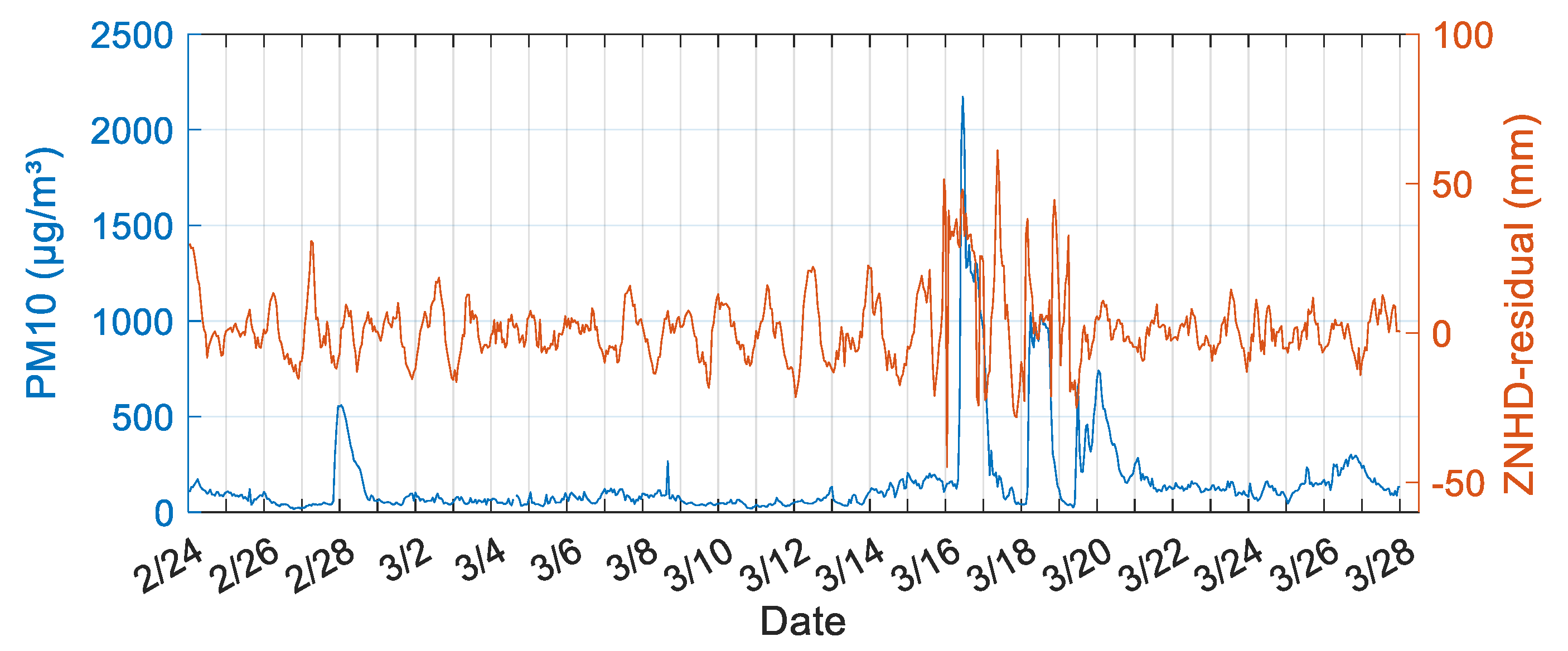
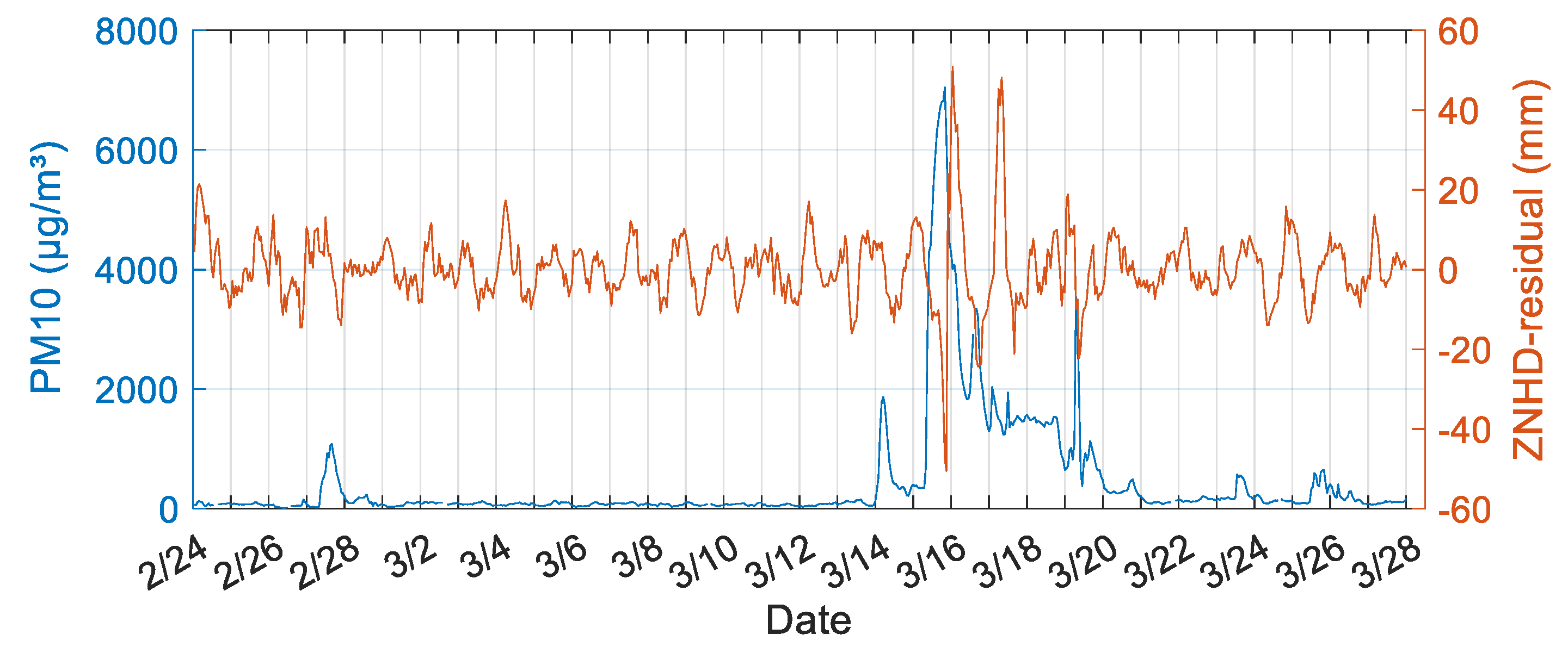
3.1. Relationship between ZNHD/PWV and PM2.5/PM10
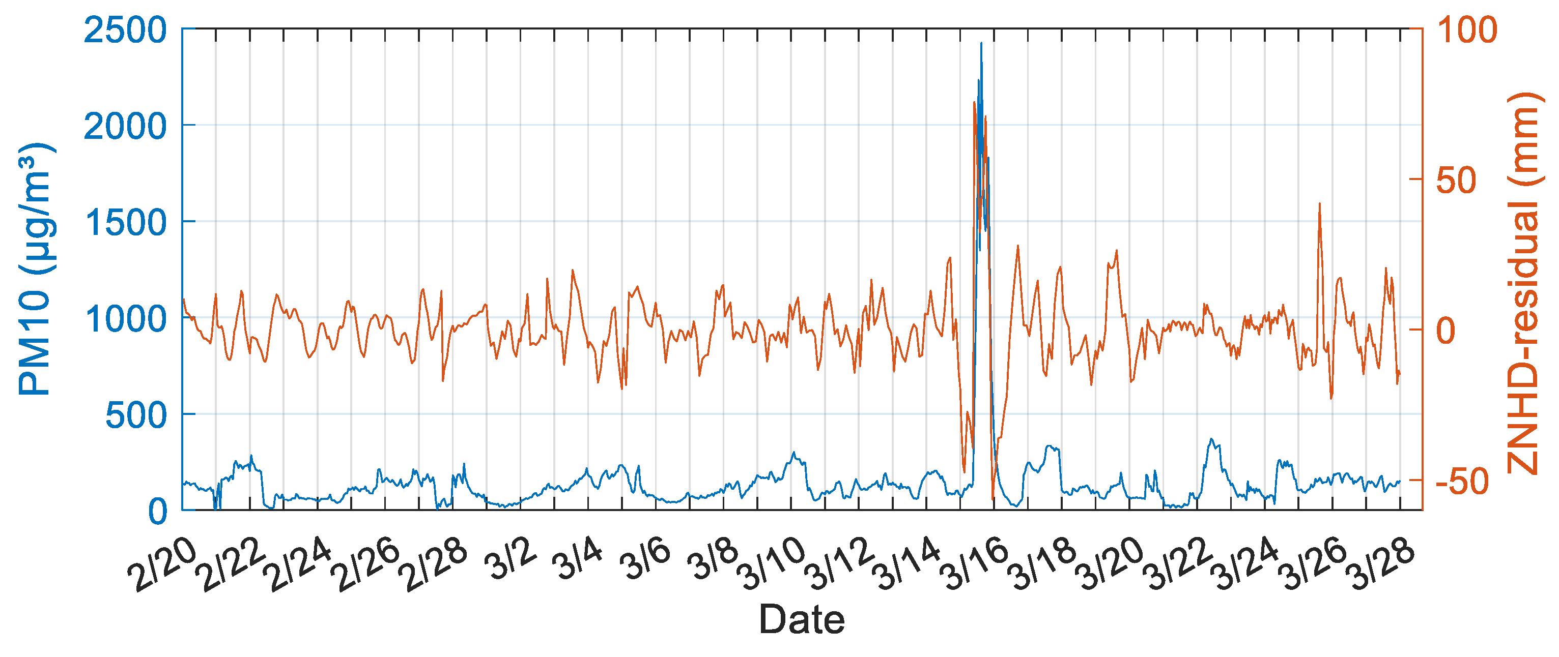
3.2. Monitoring Sandstorms Based on the ZNHD Residual
4. Conclusions
Author Contributions
Funding
Institutional Review Board Statement
Informed Consent Statement
Data Availability Statement
Acknowledgments
Conflicts of Interest
References
- Yao, L.; Lu, N.; Yue, X.; Du, J.; Yang, C. Comparison of hourly PM2.5 observations between urban and suburban areas in Beijing, China. Int. J. Environ. Res. Public Health 2015, 12, 12264–12276. [Google Scholar] [CrossRef] [PubMed]
- Kiser, D.; Metcalf, W.; Elhanan, G.; Schnieder, B.; Schlauch, K.; Joros, A.; Petersen, C.; Grzymski, J. Particulate matter and emergency visits for asthma: A time-series study of their association in the presence and absence of wildfire smoke in Reno, Nevada, 2013–2018. Environ. Health 2020, 19, 92. [Google Scholar] [CrossRef] [PubMed]
- Kuempel, E.; Attfield, M.; Vallyathan, V.; Lapp, N.; Hale, J.; Smith, R.; Castranova, V. Pulmonary inflammation and crystalline silica in respirable coal mine dust: Dose response. J. Biosci. 2003, 28, 61. [Google Scholar] [CrossRef] [PubMed]
- Lei, Y.; Chan, C.; Wang, P.; Lee, C.; Cheng, T. Effects of Asian dust event particles on inflammation markers in peripheral blood and bronchoalveolar lavage in pulmonary hypertensive rats. Environ. Res. 2004, 95, 71–76. [Google Scholar] [CrossRef]
- Wang, P.; Vuran, M.; Al-Rodhaan, M.; Al-Dhelaan, A.; Akyildiz, I. Topology analysis of wireless sensor networks for sandstorm monitoring. In Proceedings of the IEEE International Conference on Communications (ICC), Kyoto, Japan, 5–9 June 2011. [Google Scholar]
- Pun, V.; Tian, L.; Ho, K. Particulate matter from re-suspended mineral dust and emergency cause-specific respiratory hospitalizations in Hong Kong. Atmos. Environ. 2017, 165, 191–197. [Google Scholar] [CrossRef][Green Version]
- The New York Times. The Worst Dust Storm in a Decade Shrouds Beijing and Northern China. Available online: https://www.nytimes.com/2021/03/15/world/asia/china-sandstorm.html (accessed on 15 March 2021).
- NPR. Desert Dust Sweeps into Beijing, Causing China’s Worst Sandstorm in 10 Years. Available online: https://www.npr.org/2021/03/15/977397941/desert-dust-sweeps-into-beijing-causing-chinas-worst-sandstorm-in-10-years (accessed on 15 March 2021).
- Reuters. Beijing Choked in Dust Storm Stirred by Heavy Northwest Winds. 14 March 2021. Available online: https://www.reuters.com/article/us-china-weather-sandstorm/beijing-choked-in-duststorm-amid-heavy-northwest-winds-idUSKBN2B703O?il=0 (accessed on 15 March 2021).
- South China Morning Post. Six Dead, Dozens Missing as Beijing, Northern China and Mongolia Hit by Worst Sandstorm in a Decade. Available online: https://www.scmp.com/news/china/article/3125433/worst-sandstorm-decade-hits-beijing-huge-parts-northern-china (accessed on 15 March 2021).
- NASA Earth Observatory. Early Season Dust Storm Hits Beijing. Available online: https://earthobservatory.nasa.gov/images/148052/early-season-dust-storm-hits-beijing (accessed on 15 March 2021).
- World Meteorological Organization. Severe Sand and Dust Storm Hits Asia. Available online: https://public.wmo.int/en/media/news/severe-sand-and-dust-storm-hits-asia (accessed on 16 March 2021).
- Qu, J.; Hao, X.; Kafatos, M.; Wang, L. Asian dust storm monitoring combining terra and aqua MODIS SRB measurements. IEEE Geosci. Remote Sens. Lett. 2006, 3, 484–486. [Google Scholar] [CrossRef]
- Hao, X. Saharan dust storm detection using moderate resolution imaging spectroradiometer thermal infrared bands. J. Appl. Remote Sens. 2007, 1, 13510. [Google Scholar] [CrossRef]
- Xie, Y.; Zhang, W.; Qu, J. Detection of Asian dust storm using MODIS measurements. Remote Sens. 2017, 9, 869. [Google Scholar] [CrossRef]
- Sun, K.; Su, Q.; Ming, Y. Dust storm remote sensing monitoring supported by MODIS land surface reflectance database. Remote Sens. 2019, 11, 1772. [Google Scholar] [CrossRef]
- Rayegania, B.; Baratib, S.; Goshtasba, H.; Gachpaza, S.; Ramezanic, J.; Sarkheild, H. Sand and dust storm sources identification: A remote sensing approach. Ecol. Indic. 2020, 112, 106099. [Google Scholar] [CrossRef]
- Bevis, M.; Businger, S.; Herring, T.; Rocken, C.; Anthes, R.; Ware, R. GPS meteorology: Remote sensing of atmospheric water vapor using the global positioning system. J. Geophys. Res. Atmos. 1992, 97, 15787–15801. [Google Scholar] [CrossRef]
- Rohm, W. The precision of humidity in GNSS tomography. Atmos. Res. 2012, 107, 69–75. [Google Scholar] [CrossRef]
- Jiang, P.; Ye, S.; Liu, Y.; Zhang, J.; Xia, P. Near real-time water vapor tomography using ground-based GPS and meteorological data: Long-term experiment in Hong Kong. Ann. Geophys. 2014, 32, 911–923. [Google Scholar] [CrossRef]
- Benevides, P.; Catalao, J.; Miranda, P. On the inclusion of GPS precipitable water vapour in the nowcasting of rainfall. Nat. Hazards Earth Syst. Sci. 2015, 15, 2605–2616. [Google Scholar] [CrossRef]
- Yong, W.; Liu, Y.; Li, J.; Liu, L. The Effect of PM2. 5/PM10 variation based on precipitable water vapor and wind speed. J. Catastrophol. 2015, 30, 5–7. [Google Scholar]
- Ye, S.; Xia, P.; Cai, C. Optimization of GPS water vapor tomography technique with radiosonde and COSMIC historical data. Ann. Geophys. 2016, 34, 789–799. [Google Scholar] [CrossRef]
- Stoycheva, A.; Guerova, G. Study of fog in Bulgaria by using the GNSS tropospheric products and large scale dynamic analysis. J. Atmos. Sol. Terr. Phys. 2015, 133, 87–97. [Google Scholar] [CrossRef]
- Tang, X.; Hancock, C.; Xiang, Z.; Kong, Y.; Shi, L.; Jonathan Arthur Quaye-Ballard. Precipitable water vapour retrieval from GPS precise point positioning and NCEP CFSv2 dataset during typhoon events. Sensors 2018, 18, 3831. [Google Scholar] [CrossRef]
- Zhu, E.; Yang, L.; Jia, P.; Zhao, S.; Gao, Y. Correlation between GNSS Tropospheric Delay and Smog Haze; China Satellite Navigation System Management Office Academic Exchange Center: Beijing, China, 2018. [Google Scholar]
- Guo, J.; Hou, R.; Zhou, M.; Jin, X.; Li, C.; Liu, X.; Gao, H. Monitoring 2019 forest fires in southeastern Australia with GNSS technique. Remote Sens. 2021, 13, 386. [Google Scholar] [CrossRef]
- Guo, J.; Hou, R.; Zhou, M.; Jin, X.; Li, G. Detection of particulate matter changes caused by 2020 California wildfires based on GNSS and radiosonde station. Remote Sens. 2021, 13, 4557. [Google Scholar] [CrossRef]
- Zhao, Q.; Yao, Y.; Yao, W. GPS-based PWV for precipitation forecasting and its application to a typhoon event. J. Atmos. Sol. Terr. Phys. 2018, 167, 124–133. [Google Scholar] [CrossRef]
- Choy, S.; Wang, C.; Zhang, K.; Kuleshov, Y. GPS sensing of precipitable water vapour during the March 2010 Melbourne storm. Adv. Space Res. 2013, 52, 1688–1699. [Google Scholar] [CrossRef]
- Nykiel, G.; Figurski, M.; Baldysz, Z. Analysis of GNSS sensed precipitable water vapour and tropospheric gradients during the derecho event in Poland of 11 August 2017. J. Atmos. Sol. Terr. Phys. 2019, 193, 105082. [Google Scholar] [CrossRef]
- Yu, J.; Tan, K.; Zhang, C.; Zhao, B.; Wang, D.; Li, Q. Present-day crustal movement of the Chinese mainland based on Global Navigation Satellite System data from 1998 to 2018. Adv. Space Res. 2019, 63, 840–856. [Google Scholar] [CrossRef]
- Saastamoinen, J. Atmospheric correction for the troposphere and stratosphere in radio ranging satellites. Use Artif. Satell. Geod. 1972, 15, 247–251. [Google Scholar]
- Byun, S.H.; Bar-Sever, Y.E. A new type of troposphere zenith path delay product of the international GNSS service. J. Geod. 2009, 83, 367–373. [Google Scholar] [CrossRef]
- Wen, H.; Dang, Y.; Li, L. Short-Term PM2.5 concentration prediction by combining GNSS and meteorological factors. IEEE Access 2020, 8, 115202–115216. [Google Scholar] [CrossRef]
- Jin, S.G.; Luo, O.; Ren, C. Effects of physical correlations on long-distance GPS positioning and zenith tropospheric delay estimates. Adv. Space Res. 2010, 46, 190–195. [Google Scholar] [CrossRef]
- Liu, Z.; Li, Y.; Li, F.; Guo, J. Estimation and evaluation of the precipitable water vapor from GNSS PPP in Asia Region. In Lecture Notes in Electrical Engineering; Springer: Berlin/Heidelberg, Germany, 2017; pp. 85–95. [Google Scholar]
- Bevis, M.; Businger, S.; Chiswell, S.; Herring, T.A.; Randolph, H.W. GPS meteorology: Mapping zenith wet delays onto precipitable water. J. Appl. Meteorol. 1994, 33, 379–386. [Google Scholar] [CrossRef]
- Vautard, R.; Yiou, P.; Ghil, M. Singular spectrum analysis: A toolkit for short, noisy chaotic signals. Phys. D 1992, 58, 95–126. [Google Scholar] [CrossRef]
- Chen, Q.; van Dam, T.; Sneeuw, N.; Collilieux, X.; Weigelt, M.; Rebischung, P. Singular spectrum analysis for modeling seasonal signals from GPS time series. J. Geodyn. 2013, 72, 25–35. [Google Scholar] [CrossRef]
- Kondrashov, D.; Berloff, P. Stochastic modeling of decadal variability in ocean gyres. Geophys. Res Lett. 2015, 42, 1543–1553. [Google Scholar] [CrossRef]
- Shen, Y.; Guo, J.; Liu, X.; Kong, Q.; Guo, L.; Li, W. Long-term prediction of polar motion using a combined SSA and ARMA model. J. Geod. 2018, 92, 333–343. [Google Scholar] [CrossRef]
- Zhou, M.S.; Guo, J.Y.; Liu, X.; Shen, Y.; Zhao, C.M. Crustal movement derived by GNSS technique considering common mode error with MSSA. Adv. Space Res. 2020, 66, 1819–1828. [Google Scholar] [CrossRef]
- Hassani, H. Singular spectrum analysis: Methodology and comparison. J. Data Sci. 2007, 5, 239–257. [Google Scholar] [CrossRef]


| Site | GSPL | NXZW | BJFS | CHAN |
|---|---|---|---|---|
| Maximum (Max) | 6.02 | 5.61 | 5.12 | 6.06 |
| Minimum (Min) | 4.03 | 3.72 | 3.62 | 3.61 |
| Mean | 4.81 | 4.41 | 4.28 | 4.32 |
| Standard deviation (Std) | 0.53 | 0.54 | 0.43 | 0.57 |
| Before Sandstorms | During Sandstorms | After Sandstorms | |
|---|---|---|---|
| BJFS | 0.08 | 0.75 | 0.27 |
| CHAN | 0.16 | 0.71 | 0.05 |
| GSPL | 0.23 | 0.54 | 0.18 |
| NXZW | 0.14 | 0.35 | 0.24 |
Publisher’s Note: MDPI stays neutral with regard to jurisdictional claims in published maps and institutional affiliations. |
© 2022 by the authors. Licensee MDPI, Basel, Switzerland. This article is an open access article distributed under the terms and conditions of the Creative Commons Attribution (CC BY) license (https://creativecommons.org/licenses/by/4.0/).
Share and Cite
Zhou, M.; Guo, J.; Liu, X.; Hou, R.; Jin, X. Analysis of GNSS-Derived Tropospheric Zenith Non-Hydrostatic Delay Anomaly during Sandstorms in Northern China on 15th March 2021. Remote Sens. 2022, 14, 4678. https://doi.org/10.3390/rs14184678
Zhou M, Guo J, Liu X, Hou R, Jin X. Analysis of GNSS-Derived Tropospheric Zenith Non-Hydrostatic Delay Anomaly during Sandstorms in Northern China on 15th March 2021. Remote Sensing. 2022; 14(18):4678. https://doi.org/10.3390/rs14184678
Chicago/Turabian StyleZhou, Maosheng, Jinyun Guo, Xin Liu, Rui Hou, and Xin Jin. 2022. "Analysis of GNSS-Derived Tropospheric Zenith Non-Hydrostatic Delay Anomaly during Sandstorms in Northern China on 15th March 2021" Remote Sensing 14, no. 18: 4678. https://doi.org/10.3390/rs14184678
APA StyleZhou, M., Guo, J., Liu, X., Hou, R., & Jin, X. (2022). Analysis of GNSS-Derived Tropospheric Zenith Non-Hydrostatic Delay Anomaly during Sandstorms in Northern China on 15th March 2021. Remote Sensing, 14(18), 4678. https://doi.org/10.3390/rs14184678