Extraction and Analysis of Finer Impervious Surface Classes in Urban Area
Abstract
1. Introduction
2. Materials and Methods
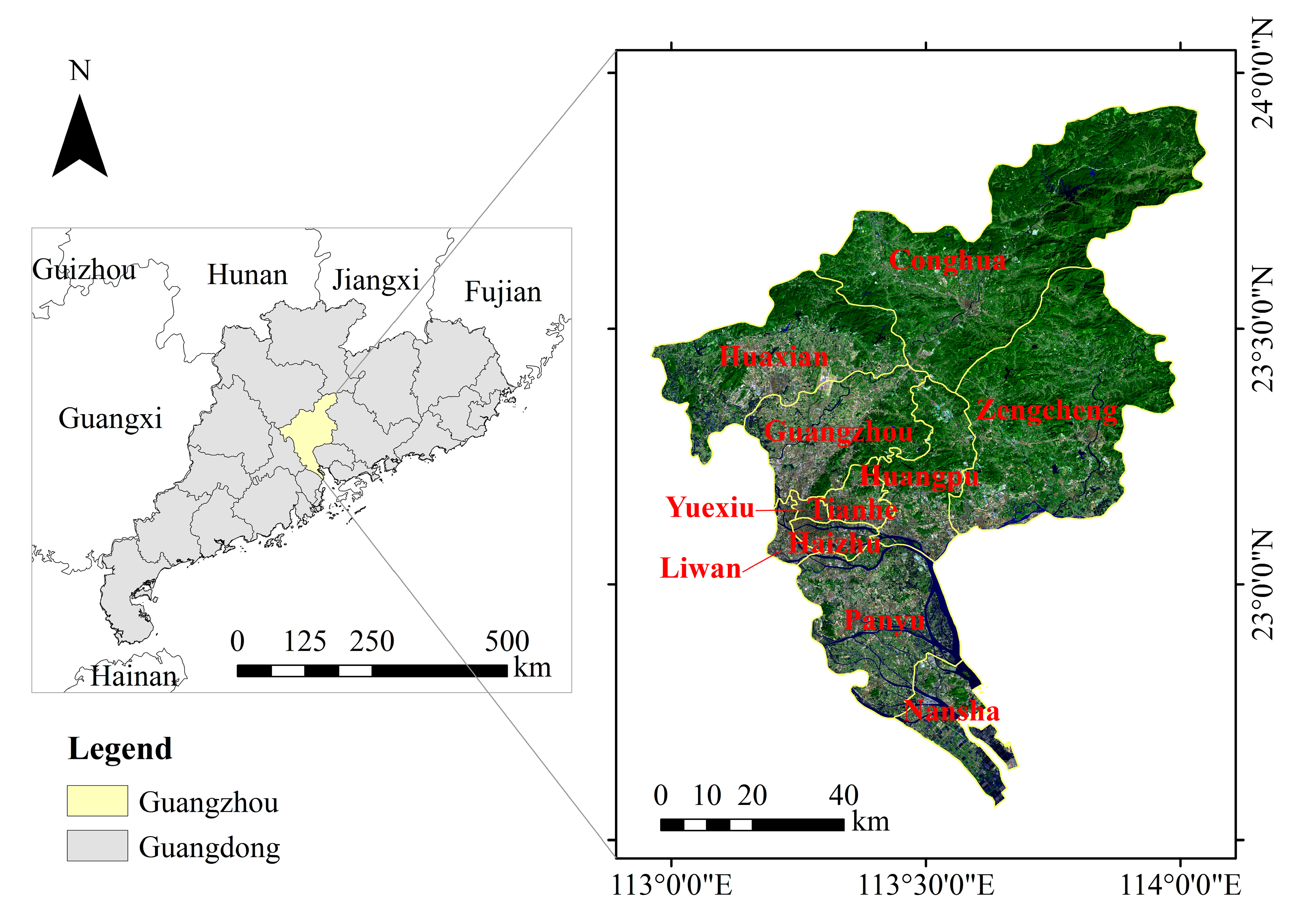
2.1. Study Area
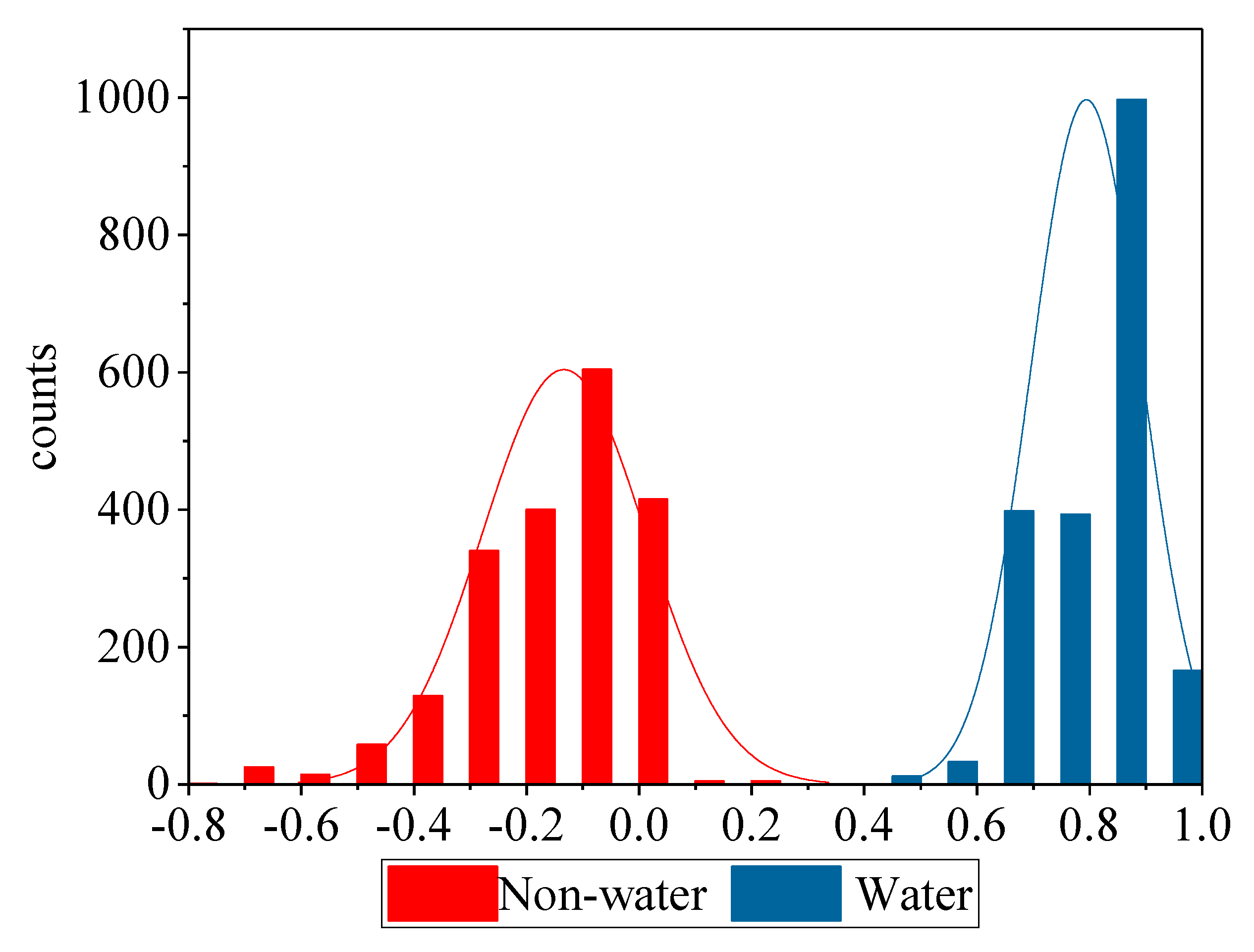
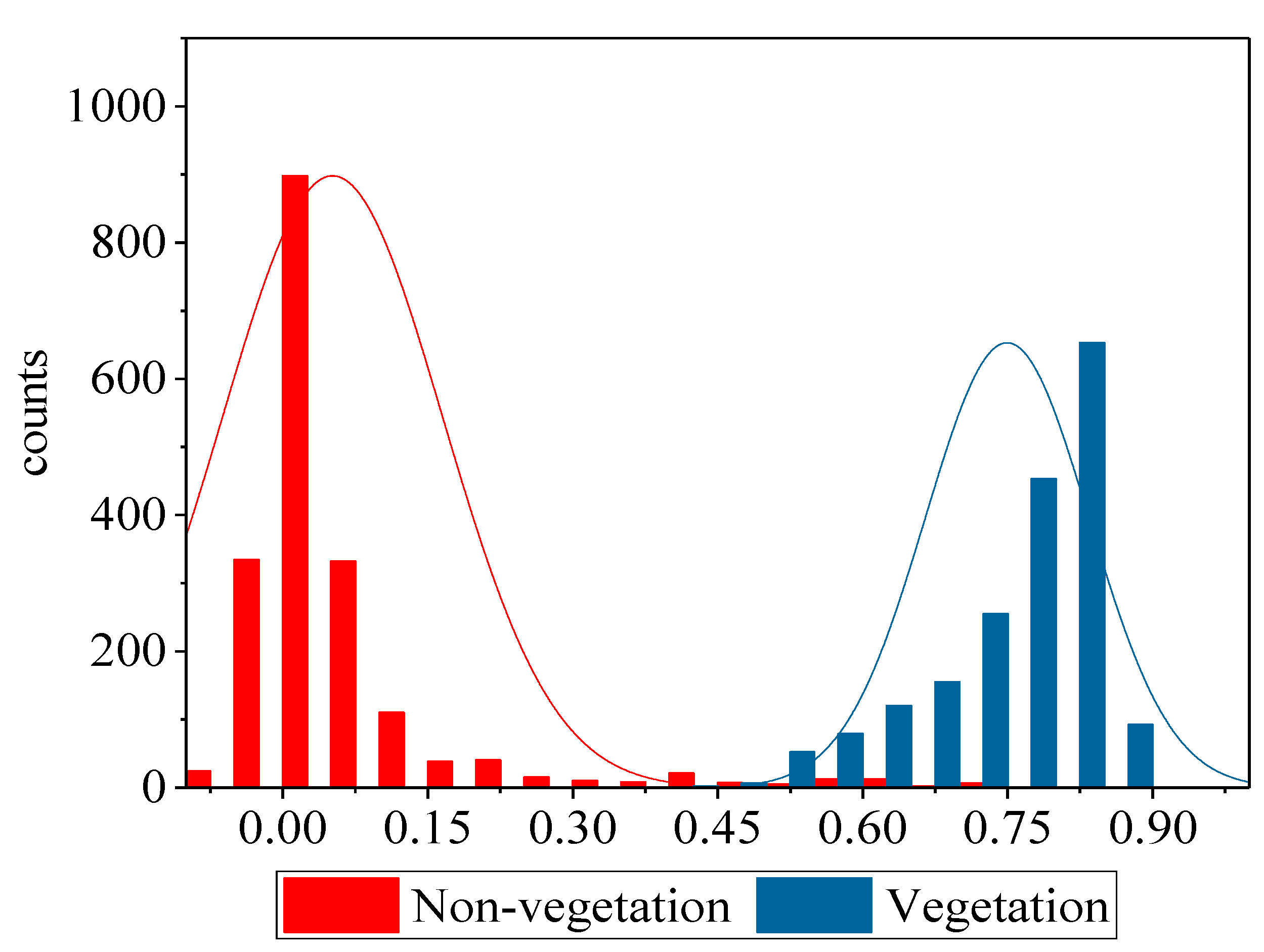
2.2. Datasets and Data Processing
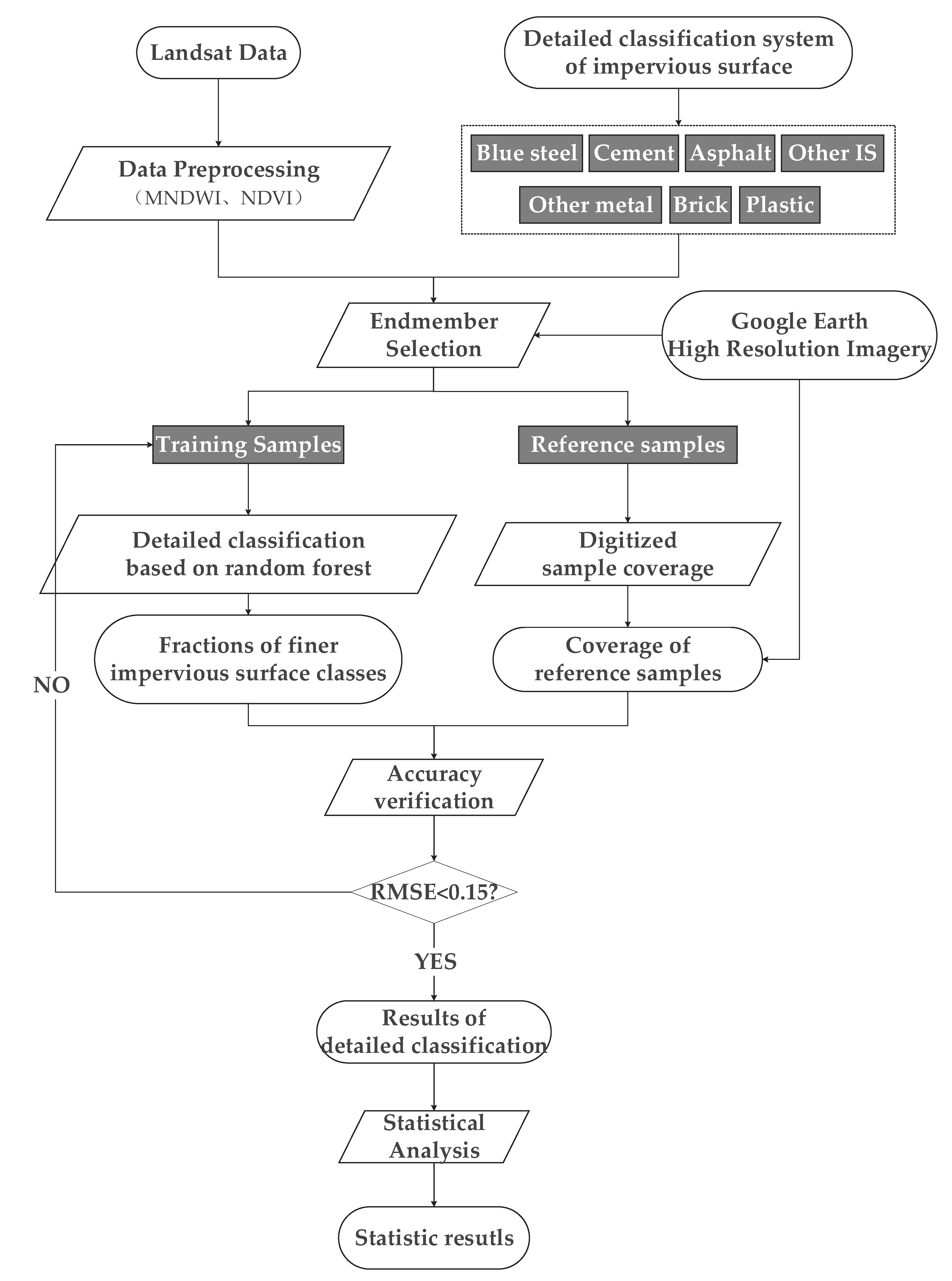
2.3. Methods
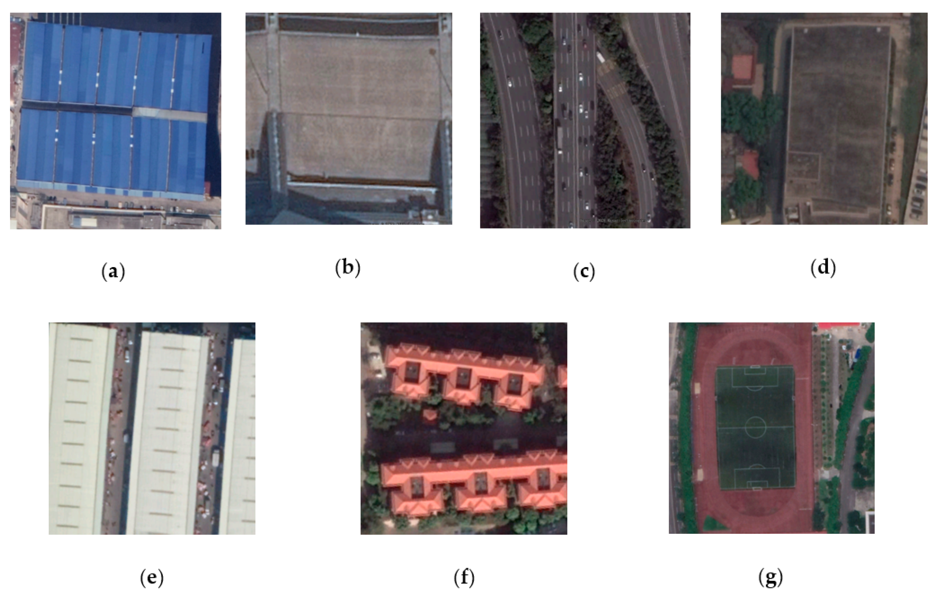
2.3.1. Finer Impervious Surfaces (IS) Classification Scheme
2.3.2. Endmember Selection
2.3.3. Random Forest-Based Detailed Classification
2.3.4. Accuracy Assessment
3. Results
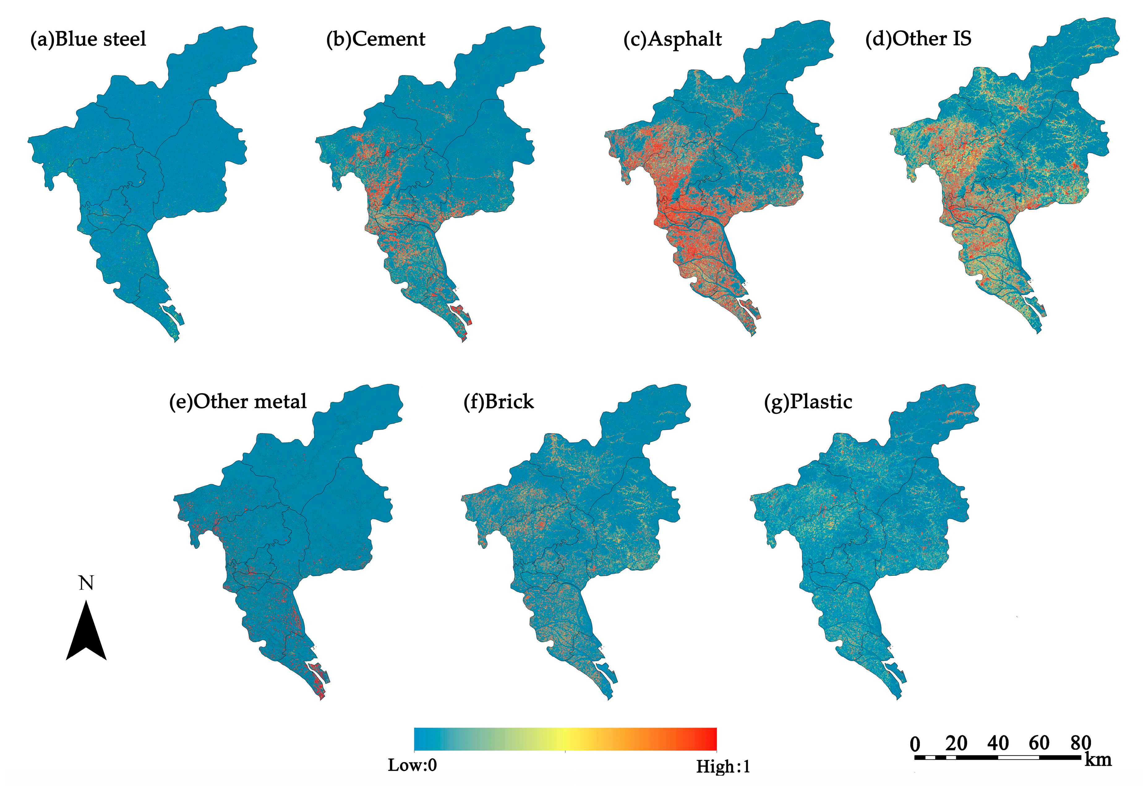
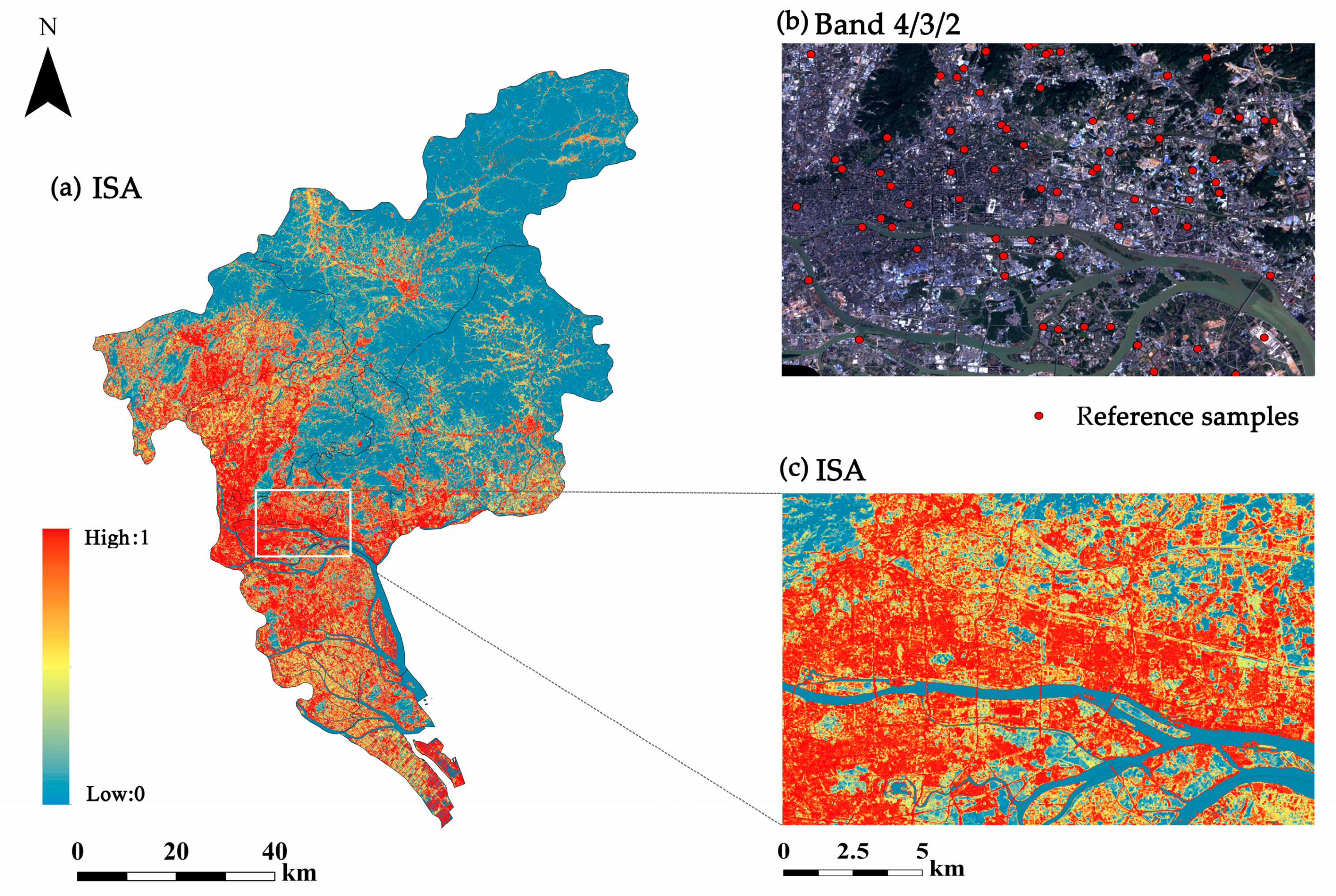
3.1. Fractions of Finer Impervious Surface Classes
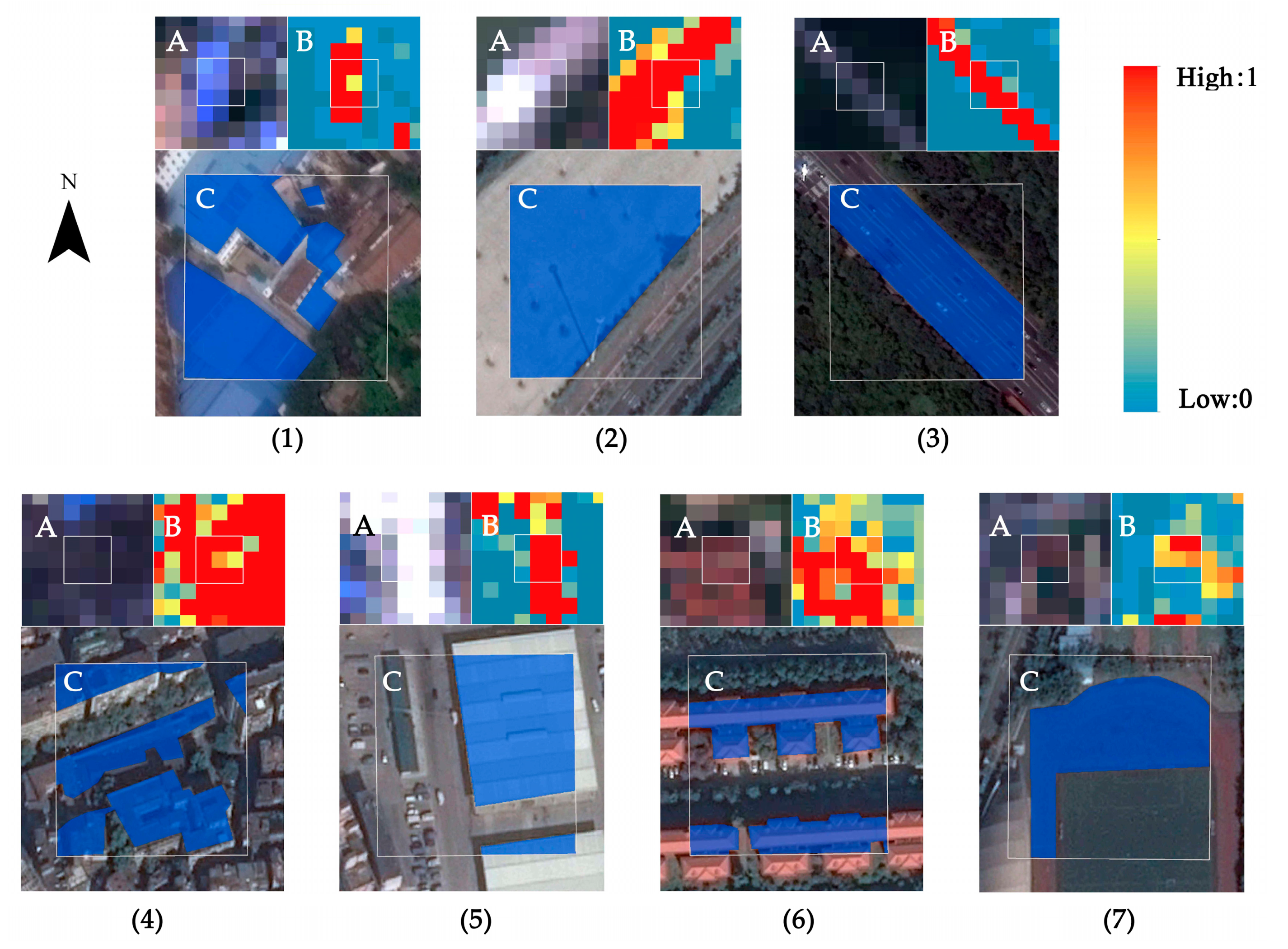
3.2. Accuracy
3.3. Statistic Results
4. Discussion
5. Conclusions
- (1)
- Finer impervious surface classes can be divided using the random forest classification method within Landsat data. RMSE values of all impervious surface classes are below 15%, with asphalt demonstrating the highest classification accuracy.
- (2)
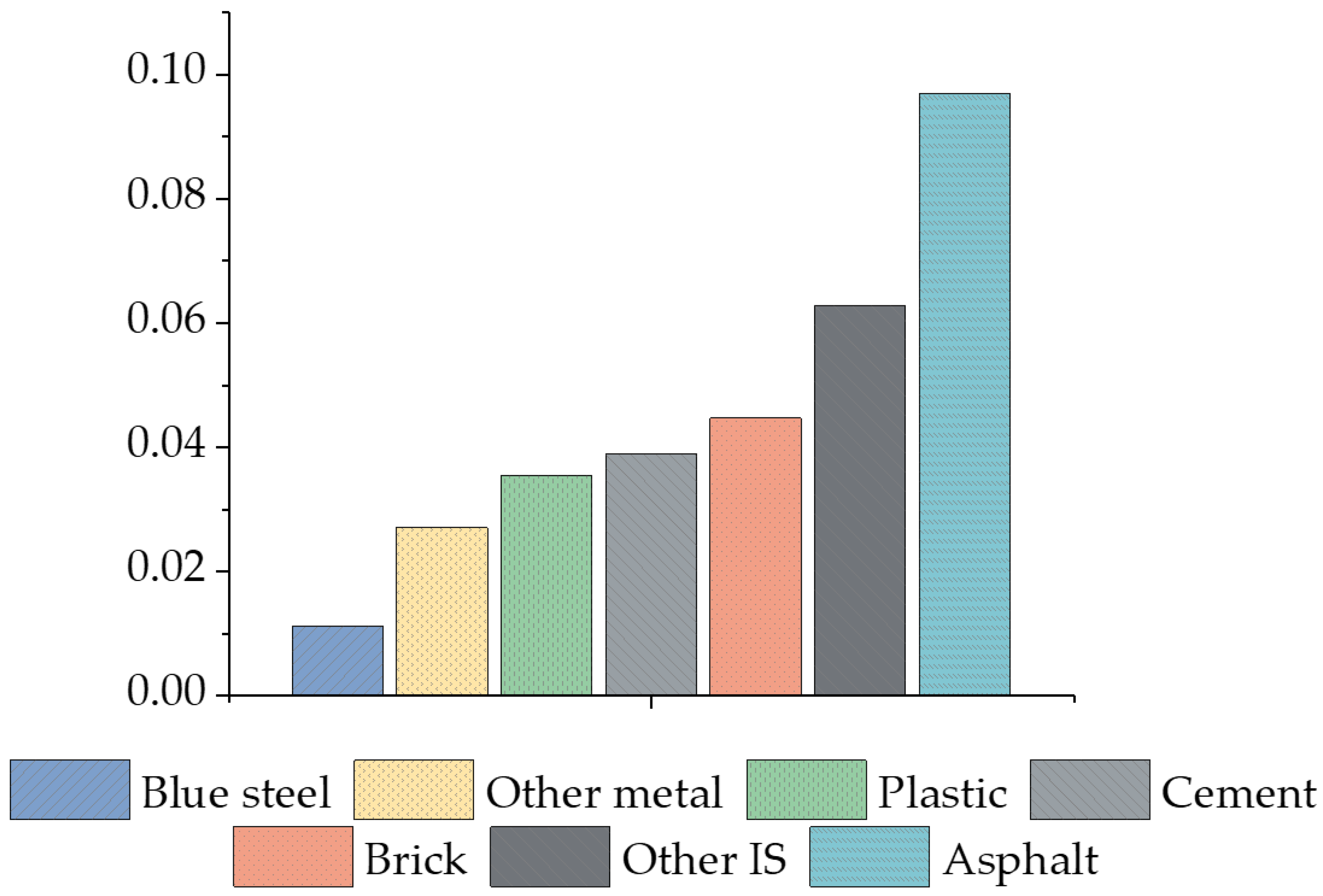
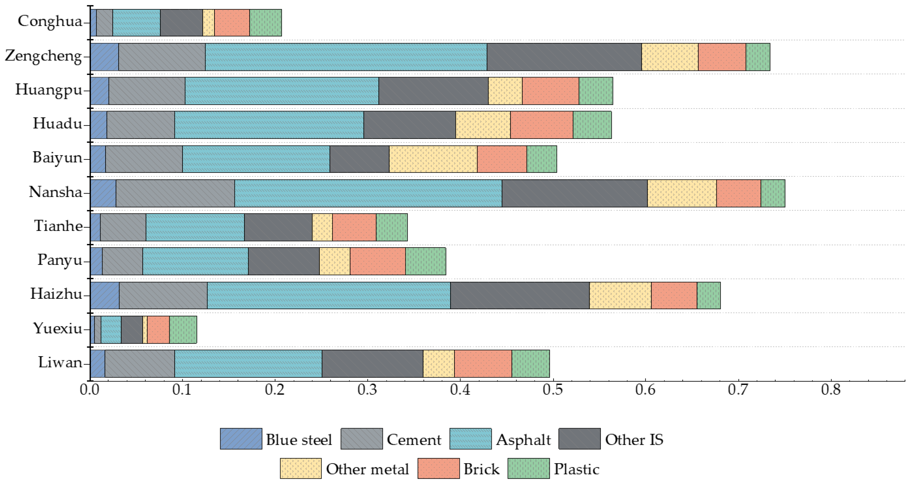
- The total area of impervious surfaces in the study area is 2258.5 km2, accounting for 36.33% of the entire Guangzhou. Asphalt, other impervious surface, and brick are the dominant impervious surface area types with the percentages of 9.68%, 6.27%, and 4.45%, respectively. They are mainly located in Yuexiu, Liwan, Haizhu, and Panyu districts.
Author Contributions
Funding
Institutional Review Board Statement
Informed Consent Statement
Data Availability Statement
Acknowledgments
Conflicts of Interest
References
- Sun, Z.; Wang, C.; Guo, H.; Shang, R. A Modified Normalized Difference Impervious Surface Index (MNDISI) for Automatic Urban Mapping from Landsat Imagery. Remote Sens. 2017, 9, 942. [Google Scholar] [CrossRef]
- Lu, D.; Hetrick, S.; Moran, E. Impervious surface mapping with Quickbird imagery. Int. J. Remote Sens. 2011, 32, 2519–2533. [Google Scholar] [CrossRef] [PubMed]
- Tang, Q.; Wang, L.; Li, B.; Yu, J. Towards a comprehensive evaluation of V-I-S sub-pixel fractions and land surface temperature for urban land-use classification in the USA. Int. J. Remote Sens. 2012, 33, 5996–6019. [Google Scholar] [CrossRef]
- Phinn, S.; Stanford, M.; Scarth, P.; Murray, A.T.; Shyy, P.T. Monitoring the composition of urban environments based on the vegetation-impervious surface-soil (VIS) model by subpixel analysis techniques. Int. J. Remote Sens. 2002, 23, 4131–4153. [Google Scholar] [CrossRef]
- Jie, J.; Wang, X. Application of land surface temperature in extracting urban impervious surfaces based on spectral mixture analysis. Mine Surv. 2018, 46, 5–11. [Google Scholar] [CrossRef]
- Wu, C.; Murray, A.T. Estimating impervious surface distribution by spectral mixture analysis. Remote Sens. Environ. 2003, 84, 493–505. [Google Scholar] [CrossRef]
- Cui, T.; Long, Y.; Wang, Y.; Hu, Q.; Liu, Y. Research on the Process of Urban Expansion In Suzhou City Based on Spectral Mixture Analysis. China Rural Water Hydropower 2016, 402, 59–62. [Google Scholar] [CrossRef]
- Yuan, C.; Wu, B.; Luo, X.; Li, Z.; Yan, N. Estimating urban impervious surface distribution with RS. Eng. Surv. Mapp. 2009, 18. [Google Scholar] [CrossRef]
- Qiu, B.; Zhang, K.; Tang, Z.; Chen, C.; Wang, Z. Developing soil indices based on brightness, darkness, and greenness to improve land surface mapping accuracy. GISci. Remote Sens. 2017, 54, 759–777. [Google Scholar] [CrossRef]
- Yan, L.; Shi, X.-F.; Yu, L.-Z.; Miao, Y.-G.; Yao, L.-P.; Li, L. Elimination effects of riparian vegetation buffer zones on surface water nitrogen and phosphorus in Shenyang suburbs. Chin. J. Eco-Agric. 2011, 19, 403–408. [Google Scholar] [CrossRef]
- Xiong, H.; Yu, C.; Li, X.; Li, L. Rapid Extraction of Impervious Surface Based on High-resolution Remotely Sensed Image. Territory Nat. Res. Study 2015, 529–554. [Google Scholar] [CrossRef]
- Zheng, Y.; Jiang, H.; Liu, W. Study on Urban Fine Land Use Classification Based on High-resolution Remote Sensing Image. J. Fujian Teach. Univ. Nat. Sci. 2017, 33, 60–68. [Google Scholar] [CrossRef]
- Chengming, Y.; Cui, P.; Pirasteh, S.; Li, J.; Li, Y. Experimental approach for identifying building surface materials based on hyperspectral remote sensing imagery. J. Zhejiang Univ. A 2017, 18, 984–990. [Google Scholar] [CrossRef]
- Jilge, M.; Heiden, U.; Neumann, C.; Feilhauer, H. Gradients in urban material composition: A new concept to map cities with spaceborne imaging spectroscopy data. Remote Sens. Environ. 2019, 223, 179–193. [Google Scholar] [CrossRef]
- Raczko, E.; Zagajewski, B. Comparison of support vector machine, random forest and neural network classifiers for tree species classification on airborne hyperspectral APEX images. Eur. J. Remote Sens. 2017, 50, 144–154. [Google Scholar] [CrossRef]
- Ren, C.; Ju, H.; Zhang, H.; Huang, J.; Zheng, Y. Multi-Source Data for Forest Land Type Precise Classification. Sci. Silvae Sinicae 2016, 52, 54–65. [Google Scholar] [CrossRef]
- Cui, X.; Liu, Z. Wetland Vegetation Classification Based on Object-based Classification Method and Multi-source Remote Sensing Images. Geom. Spatial Inf. Technol. 2018, 41, 113–116. [Google Scholar]
- Breiman, L. Random Forests. Mach. Learn. 2001, 45, 5–32. [Google Scholar] [CrossRef]
- Cai, G.; Ren, H.; Yang, L.; Zhang, N.; Du, M.; Wu, C. Detailed Urban Land Use Land Cover Classification at the Metropolitan Scale Using a Three-Layer Classification Scheme. Sensors 2019, 19, 3120. [Google Scholar] [CrossRef]
- Chen, Y.; Yun, W.; Zhou, X.; Peng, J.; Li, S.; Zhou, Y. Classification and Extraction of Land Use Information in Hilly Area Based on MESMA and RF Classifier. Trans. Chin. Soc. Agric. Mach. 2017, 48, 136–144. [Google Scholar] [CrossRef]
- Xu, H. A Study on Information Extraction of Water Body with the Modified Normalized Difference Water Index (MNDWI). J. Remote Sens. 2005, 9, 589–595. [Google Scholar] [CrossRef]
- Deering, D.W. Rangeland Reflectance Characteristics Measured by Aircraft and Spacecraft Sensors. Ph.D. Thesis, Texas A&M University, College Station, TX, USA, 1978; p. 338. [Google Scholar]
- Zhou, W.; Huang, G.; Troy, A.; Cadenasso, M. Object-based land cover classification of shaded areas in high spatial resolution imagery of urban areas: A comparison study. Remote Sens. Environ. 2009, 113, 1769–1777. [Google Scholar] [CrossRef]
- Zhou, W.; Troy, A. An object-oriented approach for analysing and characterizing urban landscape at the parcel level. Int. J. Remote Sens. 2008, 29, 3119–3135. [Google Scholar] [CrossRef]
- Chen, J.; Lin, Z.; Chen, Y. Urban Material Identification Based on Linear Mixture Model Using Hyperspectral Data. J. Basic Sci. Eng. 2009, 17, 206–218. [Google Scholar] [CrossRef]
- Fan, S.; Liu, Z.; Hu, Y. Remote Sensing Information Extraction of Urban Built-up Land Based on Spectral Signature Analysis of Normalized Difference Index. Digit. Commun. World 2019, 5–9. [Google Scholar] [CrossRef]
- Gao, Z.; Zhang, L.; Li, X.; Liao, M.; Qiu, J. Detection and analysis of urban land use changes through multi-temporal impervious surface mapping. J. Remote Sens. 2010, 14, 593–606. [Google Scholar]
- Sun, M.; Deng, Y.; Li, M.; Jiang, H.; Huang, H.; Liao, W.; Liu, Y.; Yang, J.; Li, Y. Extraction and Analysis of Blue Steel Roofs Information Based on CNN Using Gaofen-2 Imageries. Sensors 2020, 20, 4655. [Google Scholar] [CrossRef]
- Lillesand, T.; Kiefer, R.W.; Chipman, J. Remote Sensing and Image Interpretation; John Wiley and Sons: Hoboken, NJ, USA, 2015. [Google Scholar]
- Ghosh, A.; Sharma, R.; Joshi, P.K. Random forest classification of urban landscape using Landsat archive and ancillary data: Combining seasonal maps with decision level fusion. Appl. Geogr. 2014, 48, 31–41. [Google Scholar] [CrossRef]
- Lin, H.; Shao, C.; Li, H.; Gu, H.; Wang, L. Five Object-oriented Classification Methods Analysis Based on High-resolution Remote Sensing Image. Bull. Surv. Mapp. 2017, 17–21. [Google Scholar] [CrossRef]
- Guo, Y.; Chi, T.; Peng, L.; Liu, J.; Yang, L. Classification of GF-1 Remote Sensing Image Based on Random Forests for Urban Land-use. Bull. Surv. Mapp. 2016, 73–76. [Google Scholar] [CrossRef]
- Noi, P.T.; Kappas, M. Comparison of Random Forest, k-Nearest Neighbor, and Support Vector Machine Classifiers for Land Cover Classification Using Sentinel-2 Imagery. Sensors 2017, 18, 18. [Google Scholar] [CrossRef]
- Li, W. Mapping Urban Impervious Surfaces by Using Spectral Mixture Analysis and Spectral Indices. Remote Sens. 2019, 12, 94. [Google Scholar] [CrossRef]
- Lu, D.; Weng, Q. Spectral Mixture Analysis of the Urban Landscape in Indianapolis with Landsat ETM+ Imagery. Photogramm. Eng. Remote Sens. 2004, 70, 1053–1062. [Google Scholar] [CrossRef]
- Zhong, Y.; Hu, X.; Luo, C.; Wang, X.; Zhao, J.; Zhang, L. WHU-Hi: UAV-borne hyperspectral with high spatial resolution (H2) benchmark datasets and classifier for precise crop identification based on deep convolutional neural network with CRF. Remote Sens. Environ. 2020, 250, 112012. [Google Scholar] [CrossRef]
- Tang, J. Analysis on the Redevelopment Policy of Urban Inefficient Land. China Land 2013, 41–43. [Google Scholar] [CrossRef]
- Wang, C.; Sun, J.; Hu, F.; Jiang, W. Observation and Analysis of the Characteristics of Urban Concrete Surface Energy Balance. J. Nanjing Univ. Nat. Sci. Ed. 2007, 43, 270–279. [Google Scholar]
- Li, S.; Huang, T. Influence on Rainfall Run-off due to Urbanization and Rain-water Flood Control in the City. China Munic. Eng. 2002, 35–37. [Google Scholar] [CrossRef]
- Khare, P.; Machesky, J.; Soto, R.; He, M.; Presto, A.A.; Gentner, D.R. Asphalt-related emissions are a major missing nontraditional source of secondary organic aerosol precursors. Sci. Adv. 2020, 6, eabb9785. [Google Scholar] [CrossRef]
- Xu, H. Quantitative analysis on the relationship of urban impervious surface with other components of the urban ecosystem. Acta Ecol. Sin. 2009, 29, 2456–2462. [Google Scholar] [CrossRef]
- Elhacham, E.; Ben-Uri, L.; Grozovski, J.; Bar-On, Y.M.; Milo, R. Global human-made mass exceeds all living biomass. Nat. Cell Biol. 2020, 588, 442–444. [Google Scholar] [CrossRef]
- Li, J.; Song, C.; Cao, L.; Zhu, F.; Meng, X.; Wu, J. Impacts of landscape structure on surface urban heat islands: A case study of Shanghai, China. Remote Sens. Environ. 2011, 115, 3249–3263. [Google Scholar] [CrossRef]
- Jensen, J.R.; Lulla, K. Introductory digital image processing: A remote sensing perspective. Geocarto Int. 1987, 2, 65. [Google Scholar] [CrossRef]
- Burghardt, W. Soil sealing and soil properties related to sealing. Geol. Soc. Lond. Spéc. Publ. 2006, 266, 117–124. [Google Scholar] [CrossRef]
- Zhou, H.; Hu, D.; Wang, X.; Han, F.; Li, Y.; Wu, X.; Ma, S. Horizontal Heat Impact of Urban Structures on the Surface Soil Layer and Its Diurnal Patterns under Different Micrometeorological Conditions. Sci. Rep. 2016, 6, 18790. [Google Scholar] [CrossRef]
- Fan, S.; Hu, Y.; Liu, Z. Research of Information Extraction of City Building Based on a New Object-Oriented Method. J. South China Norm. Univ. (Nat. Sci. Ed.) 2015, 47, 91–97. [Google Scholar] [CrossRef]
- Li, M.; Nian, Y.; Bian, R.; Bai, Y.; Ma, J. Classification of Picea crassifolia and Sabina przewalskii based on Multi-source Remote Sensing Images. Remote Sens. Technol. Appl. 2020, 35, 128–136. [Google Scholar] [CrossRef]
- Li, M.; Stein, A.; Bijker, W.; Zhan, Q. Urban land use extraction from Very High Resolution remote sensing imagery using a Bayesian network. ISPRS J. Photogramm. Remote Sens. 2016, 122, 192–205. [Google Scholar] [CrossRef]
- Iftene, M.; Liu, Q.; Wang, Y. Very high-resolution images classification by fine tuning deep convolutional neural networks. In Proceedings of the Eighth International Conference on Digital Image Processing (ICDIP 2016), Chengdu, China, 20–22 May 2016; Volume 10033, p. 100332D. [Google Scholar]
- Yan, L.; Li, Q.; Wang, Y.; Ye, Z. Classification Performance of Airborne Mid-wave Infrared Imagery. Remote Sens. Inf. 2019, 34, 7–14. [Google Scholar] [CrossRef]
- Wang, Q.; Blackburn, G.A.; Onojeghuo, A.O.; Dash, J.; Zhou, L.; Zhang, Y.; Atkinson, P.M. Fusion of Landsat 8 OLI and Sentinel-2 MSI Data. IEEE Trans. Geosci. Remote Sens. 2017, 55, 3885–3899. [Google Scholar] [CrossRef]
- Mao, W.; Xia, L. Analysis on spatial-temporal change monitoring of urban resilience. Bull. Surv. Mapp. 2019, 141–144. [Google Scholar] [CrossRef]
- Xiu, C.; Wei, Y.; Wang, Q. Evaluation of urban resilience of Dalian city based on the perspective of “Size-Density-Morphology”. Acta Geogr. Sin. 2018, 73, 2315–2328. [Google Scholar] [CrossRef]
- Yang, Y.; Lin, L.; Zhong, Z.; Ou, Y.; Xu, Q.; Meng, M.; Hao, S. Comprehensive evaluation and spatial differentiation of community resilience in Guangzhou based on response of the city to public health hazards. Acta Geogr. Sin. 2019, 74, 266–284. [Google Scholar] [CrossRef]
- Jenerette, G.D.; Harlan, S.L.; Buyantuev, A.; Stefanov, W.L.; Declet-Barreto, J.; Ruddell, B.L.; Myint, S.W.; Kaplan, S.; Li, X. Micro-scale urban surface temperatures are related to land-cover features and residential heat related health impacts in Phoenix, AZ USA. Landsc. Ecol. 2016, 31, 745–760. [Google Scholar] [CrossRef]
- Kang, J.; Körner, M.; Wang, Y.; Taubenböck, H.; Zhu, X.X. Building instance classification using street view images. ISPRS J. Photogramm. Remote Sens. 2018, 145, 44–59. [Google Scholar] [CrossRef]



| Classes | Training Samples (1-Pixel, 30 m × 30 m) | Reference Samples (3-Pixel, 90 m × 90 m) |
|---|---|---|
| Blue steel | 23 | 25 |
| Cement | 10 | 35 |
| Asphalt | 10 | 30 |
| Other IS 1 | 5 | 30 |
| Other metal | 8 | 17 |
| Brick | 8 | 30 |
| Plastic | 6 | 30 |
| Other classes 2 | 33 | 34 |
| Total | 103 | 231 |
| Class | Area (km2) |
|---|---|
| Blue steel | 78.79 |
| Cement | 276.72 |
| Asphalt | 691.71 |
| Other IS 1 | 447.84 |
| Other metal | 192.31 |
| Brick | 318.43 |
| Plastic | 252.72 |
| Guangzhou | 7147.81 |
| District Name | District Area | Blue Steel | Cement | Asphalt | Other IS | Other Metal | Brick | Plastic |
|---|---|---|---|---|---|---|---|---|
| Baiyun | 671.24 | 11.12 | 50.61 | 106.52 | 73.46 | 22.84 | 41.25 | 27.59 |
| Conghua | 1981.24 | 9.58 | 13.72 | 44.19 | 46.08 | 8.99 | 47.73 | 58.30 |
| Haizhu | 100.82 | 3.18 | 9.60 | 26.52 | 15.11 | 6.77 | 4.98 | 2.53 |
| Huadu | 955.20 | 12.63 | 42.03 | 108.79 | 73.46 | 31.69 | 57.06 | 41.45 |
| Huangpu | 457.11 | 5.17 | 22.71 | 48.57 | 33.35 | 9.92 | 21.58 | 15.46 |
| Liwan | 70.88 | 2.01 | 9.06 | 20.47 | 11.15 | 5.28 | 3.42 | 1.83 |
| Nansha | 336.22 | 5.83 | 27.89 | 53.50 | 21.55 | 31.93 | 18.00 | 10.92 |
| Panyu | 798.75 | 14.72 | 58.27 | 163.40 | 79.04 | 47.65 | 53.63 | 33.22 |
| Tianhe | 127.64 | 2.62 | 10.47 | 26.78 | 15.04 | 4.72 | 7.78 | 4.66 |
| Yuexiu | 32.89 | 1.03 | 3.07 | 10.01 | 5.50 | 2.01 | 1.69 | 0.87 |
| Zengcheng | 1615.81 | 10.90 | 29.29 | 82.96 | 74.11 | 20.51 | 61.32 | 55.88 |
Publisher’s Note: MDPI stays neutral with regard to jurisdictional claims in published maps and institutional affiliations. |
© 2021 by the authors. Licensee MDPI, Basel, Switzerland. This article is an open access article distributed under the terms and conditions of the Creative Commons Attribution (CC BY) license (http://creativecommons.org/licenses/by/4.0/).
Share and Cite
Liao, W.; Deng, Y.; Li, M.; Sun, M.; Yang, J.; Xu, J. Extraction and Analysis of Finer Impervious Surface Classes in Urban Area. Remote Sens. 2021, 13, 459. https://doi.org/10.3390/rs13030459
Liao W, Deng Y, Li M, Sun M, Yang J, Xu J. Extraction and Analysis of Finer Impervious Surface Classes in Urban Area. Remote Sensing. 2021; 13(3):459. https://doi.org/10.3390/rs13030459
Chicago/Turabian StyleLiao, Wenyue, Yingbin Deng, Miao Li, Meiwei Sun, Ji Yang, and Jianhui Xu. 2021. "Extraction and Analysis of Finer Impervious Surface Classes in Urban Area" Remote Sensing 13, no. 3: 459. https://doi.org/10.3390/rs13030459
APA StyleLiao, W., Deng, Y., Li, M., Sun, M., Yang, J., & Xu, J. (2021). Extraction and Analysis of Finer Impervious Surface Classes in Urban Area. Remote Sensing, 13(3), 459. https://doi.org/10.3390/rs13030459


