Abstract
Satellite remote sensing is well demonstrated to be a powerful tool for investigating ancient land use in Southwest Asia. However, few regional studies have systematically integrated satellite-based observations with more intensive remote sensing technologies, such as drone-deployed multispectral sensors and ground-based geophysics, to explore off-site areas. Here, we integrate remote sensing data from a variety of sources and scales including historic aerial photographs, modern satellite imagery, drone-deployed sensors, and ground-based geophysics to explore pre-modern land use along the Upper Diyala/Sirwan River in the Kurdistan Region of Iraq. Our analysis reveals an incredible diversity of land use features, including canals, qanats, trackways, and field systems, most of which likely date to the first millennium CE, and demonstrate the potential of more intensive remote sensing methods to resolve land use features. Our results align with broader trends across ancient Southwest Asia that document the most intensive land use in the first millennium BCE through the first millennium CE. Land use features dating to the earlier Bronze Age (fourth through second millennium BCE) remain elusive and will likely require other investigative approaches.
Keywords:
land use; archaeology; agriculture; Mesopotamia; ancient Iraq; historic imagery; CORONA; UAVs; multispectral; magnetometry 1. Introduction
Ancient land-use features, such as field boundaries, trackways, and canals, constitute invaluable records of past land use practices [1,2,3], providing unique insights into ancient subsistence practices, agricultural economies, human–environment relationships, and movement across landscapes. In Mesopotamia, which includes the Tigris–Euphrates river basin in modern Iraq and adjacent regions, our understanding of the land use history is strongly informed by two areas where land use features are exceptionally well-preserved and tend to be readily visible on satellite imagery: (1) the rainfed farming zones in the steppe regions of Northern Mesopotamia (i.e., the Jezirah) and (2) the irrigated zones in the arid alluvial plains of Southern Mesopotamia (Figure 1). In both areas, the preserved land use features and their association with settlement patterns reveal a great deal about ancient societies and the processes by which they modified landscapes [2,4].
For example, in Southern Mesopotamia, the alluvial plain is crosscut by vast and intricate canal networks visible on the ground and in satellite imagery [5,6,7,8,9,10,11].
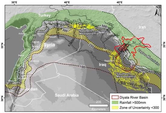
Figure 1.
Map of major agricultural zones (and land use features), river systems, and average annual rainfall isohyets (dashed lines, mm) in ancient Southwest Asia (Source: GPCC [12]). Yellow lines represent “hollow ways” [13,14] and ancient water channels [6,15] in Northern and Southern Mesopotamia, respectively. The Diyala/Sirwan River basin is outlined in red, and the Sirwan Regional Project (SRP) survey area is colored in semi-transparent red. Green and yellow areas represent zones of secure and unreliable agriculture, respectively [16]. Topographic basemap generated from 1 arc-second Shuttle Radar Topography Mission (SRTM) digital elevation model (DEM) (courtesy of the USGS).
Habitation in this extremely arid region is dependent on water from rivers and wetland areas. Thus, settlements are typically arranged in linear patterns, along levees and canals, or along the wetland edges, and shift with the construction, use, and abandonment of water management features [5,6,7,17]. In rainfed Northern Mesopotamia during the Bronze Age (late 4th–2nd millennium BCE), long-lived, nucleated settlements, agricultural extensification, and pastoral intensification all coordinated to form a distinctive network of linear routeways, or “hollow ways” [14,18,19,20]. From the first millennium BCE onwards, technological advances and imperial initiatives transformed the landscape in Northern Mesopotamia, inscribing it with networks of water management features, including canals and qanat systems [21,22,23]. Qanat systems are networks of subterranean channels and tunnels that use the natural geology and hydrology to direct water from the water table to the surface [24].
However, to the north and east, these two agricultural regions are flanked by hilly steppe and piedmont zones, which despite having a long history of human settlement, are comparatively devoid of land use features. Hilly steppe and piedmont zones might lack land use features because the environment poses limits on agricultural potential resulting in lower population density and less centralized political power [25,26]. Similarly, a land use history that emphasized sheep and goat animal husbandry would leave few archaeological traces. However, it is unclear to what degree our understanding of past land use in piedmont zones is simply a result of preservation bias (i.e., land use features existed but have been destroyed) or the low visibility of sites and land use features in satellite imagery (i.e., land use and associated features were ephemeral or are not distinguishable using satellite data). The limited archaeological evidence for past land use practices in the “hilly flanks” of Mesopotamia [27,28] serves as a stumbling block in building a comprehensive understanding of past subsistence, economic interactions, and environmental relationships in the wider region.
This study presents results of a systematic and multiscalar assessment of land use features in the Zagros piedmont zone along the Diyala/Sirwan River in the Kurdistan Region of Iraq. The Upper Diyala/Sirwan River region is an environmentally transitional zone encompassing areas at higher elevations where rainfed farming is possible down to lower elevations where irrigation is necessary for viable agriculture. It is also a cultural and political borderland region connecting societies in the Zagros Mountains with the southern Mesopotamian lowlands. The long history of human occupation in the region [29] makes it an ideal place to investigate the dynamic history of land use practices across a diversity of ecological zones. The goals of this study are twofold: (1) to determine the diversity and intensity of ancient land use in the Upper Diyala/Sirwan region through a systematic survey using historic aerial and satellite imagery (2) to test the potential of more intensive remote sensing methods using drone-mounted sensors and ground-based geophysics to resolve land use around several key archaeological sites. Results from this study offer powerful new perspectives on the history of agricultural land use in the Upper Diyala/Sirwan region and build on research begun decades ago in the lower Diyala [6]. More broadly, the results demonstrate the potential of integrated satellite and ground-based remote sensing to investigate ancient land use in Mesopotamia’s piedmont zones and in similar environments around the world.
Study Region
The river known as the Diyala in Arabic and the Sirwan in Kurdish is a major tributary of the Tigris River, flowing south from its headwaters in the Zagros Mountains of Iran to its confluence with the Tigris just below modern Baghdad (Figure 2). The region experiences a steep environmental and elevational gradient connecting the Zagros Mountain highlands and the Southern Mesopotamian lowlands. Topographically, the region is defined by hilly anticlines running northwest to southeast punctuated by several agricultural valleys fed by snowmelt streams and artesian springs along the Zagros foothills.
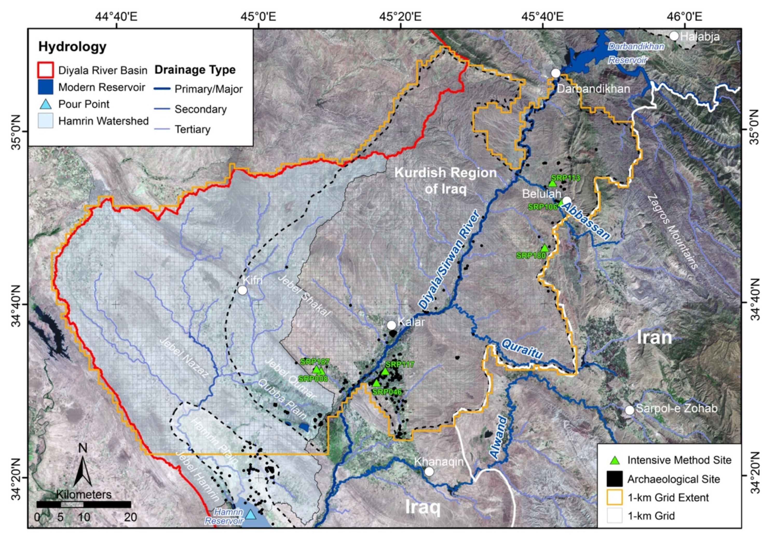
The Diyala/Sirwan basin has been the focus of major archaeological investigations since the 1920s [30,31,32,33,34], and the plains of the lower Diyala were the site of Robert McCormick Adams’ groundbreaking regional survey [6]. To the north, in the Middle Diyala region, the construction of the Hamrin Dam spurred a series of salvage projects in the 1970s, including a survey of the basin [35]. Far to the north in the Shahrizor plain, where the Tanjero and Sirwan rivers meet to form the Diyala/Sirwan River, more recent investigations have been undertaken by a variety of international projects [36,37]. However, until recently, little was known about the archaeology or land use history of the Diyala/Sirwan river valley along the 100 km zone between the Hamrin and the Shahrizor (Figure 2).
From 2012 to 2019, the Sirwan Regional Project (SRP) undertook a series of multiscalar archaeological investigations in the area of the upper Diyala/Sirwan between the Hamrin Basin and the Darbandikhan dam in the modern Kurdish province of Garmian. The project documented hundreds of archaeological sites and land use features through a regional survey effort, as well as undertaking both test and large-scale excavations at numerous sites, helping to reconstruct the area’s long history of human occupation [29,38,39,40,41,42,43]. This paper builds on the initial results of the SRP through a systematic remote sensing survey of pre-modern land use in the Upper Diyala/Sirwan region, as well as offering a comparison of land use in the study area within broader trends occurring across the ancient, semi-arid Southwest Asia.
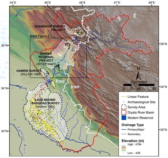
Figure 2.
Archaeological surveys along the Iraq side of the Diyala/Sirwan River Basin. Linear land use features in the Land Behind Baghdad Survey were digitized from [6] (see also Jotheri [15,44]) and those in the Shahrizor survey area are reported by Mühl et al. [37]. Digital elevation model (DEM) basemap and hydrological features are derived from 1 arc-second Shuttle Radar Topography Mission (SRTM) (courtesy NASA and USGS). Dashed white lines are average annual precipitation isohyets (1951–2000) [45]. We generated a 1 km2 search grid (Figure 3).
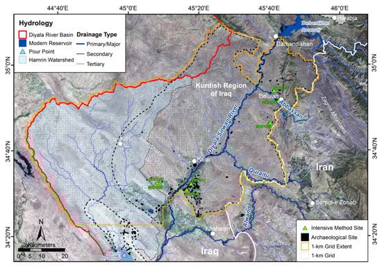
Figure 3.
Systematic 1 km2 survey area of the Upper Diyala/Sirwan region. Green triangles indicate sites where intensive remote sensing methods were deployed. Hydrological features are indicated in blue and red. The watershed for the western side of modern Lake Hamrin is highlighted in light blue, and all water in this area drains to the pour point (blue triangle). The basemap is Landsat 8 imagery from 4 October 2021 (courtesy of the USGS and NASA).
2. Materials and Methods
2.1. Systematic Regional Survey
Archaeology in Southwest Asia has a long history of regional survey that incorporates aerial perspectives and remote sensing ([46]; e.g., [2,8,47,48,49,50,51,52]). In fact, archaeologists working in Southwest Asia have been particularly pioneering in the use of historic aerial photography and declassified spy satellite imagery ([46]; e.g., [14,53,54,55,56,57]), and the use of declassified 1960–1972 CORONA imagery is now commonplace in regional studies thanks to the availability of orthorectified imagery from the CORONA Atlas [53,54]. Historic imagery of Southwest Asia is a valuable tool because it provides a high-resolution record of archaeological landscapes that have been destroyed by rapidly expanding urbanization, agricultural intensification, and hydropower dam construction over the last several decades [58].
This study aims to systematically document land use features in the Upper Diyala/Sirwan region using aerial and satellite imagery aided by historic maps and digital elevation data (Table 1). Within ArcMap 10.6, we generated a 1 km2 search grid (6450 km2 total) over the Upper Diyala/Sirwan region bounded by the Iran–Iraq border to the east, the boundary of the Upper Diyala/Sirwan basin to the west, and between the Darbandikhan reservoir and the northern edge of the Hamrin agricultural plain to the north and south, respectively (Figure 3). We systematically searched each imagery dataset and digitized linear features not currently in use at the time or in alignment with historic maps.

Table 1.
Dates and specifications of historic maps and imagery used in this study.
2.1.1. Feature Identification
Ancient land use features in ancient Southwest Asia tend to be particularly visible on historic imagery because of the region’s unique topographic, environmental, vegetation, and preservation conditions, i.e., landscapes are flat with little precipitation and vegetation cover. Here, land use features are preserved as traces of movement (e.g., roads, trackways, boundaries), subsistence activities (e.g., agricultural cultivation, including field boundaries and canals, and pastoral management such as desert kites, pens, and trackways), water management (e.g., canals, dams, siphons, and qanats), and political and religious practices (e.g., monuments, processional routes, and sacred areas).
We employed a “brute force” approach to feature identification [61], relying on the experience and expertise the authors have gained from years of observing land use features on imagery and on the ground through archaeological surveys in the study area. While ancient water management features and trackways can have similar appearances on historic imagery (i.e., dark linear depressions with light-colored edges), in many cases, consultation with previously published studies (especially: [2,18,58]) and contextual information was sufficient to differentiate between them. For example, large water management features, such as primary canals, have large distinct upcast mounds and clearly tap primary water sources. Other linear features can be distinguished as water management features by their association with qanat shafts. Trackways are often distinguishable if they clearly radiate away from known archaeological sites (like “hollow ways”) or pass over areas of high topographic relief. In cases where it remained difficult to distinguish a feature’s function, features are labeled generically as “linear features.” Finally, this study referenced a wealth of published and ongoing survey data [29,41] to help constrain the dates of land use features––data that may not be readily available to other remote sensing studies.
2.1.2. DEM and Hydrology
In cases where the formation process of a linear feature was ambiguous, we also used Google Earth-derived elevation profiles to aid interpretation, as recommended by Rayne and Donoghue [21]. Rayne and Donoghue [21] suggest that features that consistently decrease in elevation are likely gravity aided water management features. To better visualize topographic changes and further aid the interpretation of land use features, we also created watershed and drainage models of the Diyala/Sirwan River basin with the Shuttle Radar Topography Mission (SRTM) digital elevation model (DEM) using the ArcGIS 10.6.1 hydrology toolset. Within the larger Diyala/Sirwan basin, we generated smaller watersheds to better visualize the drainage patterns in the region and understand the technology required or potential return-on-investment for moving water through higher elevation areas. Drainage types were calculated using the stream order tool with the Strahler method in the ArcGIS 10.6.1 hydrology toolbox. Primary, secondary, and tertiary drainages (see Figure 3 legend) include stream orders 7–8, 5–6, and 3–4, respectively. Stream orders 1–2 are not pictured.
2.2. Targeted Intensive Survey
While some traces of ancient land use are well preserved and clearly visible today, others are more ephemeral and may require particular environmental conditions or instrumentation to resolve subtle changes in elevation, vegetation health, or soil composition. In this study, we employ both terrestrial geophysics (magnetic gradiometry) and drone-acquired, high-resolution multispectral imaging in order to determine whether ancient land use features might be resolvable using these methods, even when no such features are evident in visible light aerial and satellite imagery. Intensive surveys were undertaken at seven sites in the region, selected to encompass a variety of (pre-)historic periods, occupational lengths, environments, and modern land use conditions (see Figure 3; Table 2).
Table 2.
Sites with magnetometry and drone-based multispectral surveys.
2.2.1. Magnetic Gradiometry
Ground-based geophysics, especially magnetic gradiometry (magnetometry), is a popular and effective tool for documenting a wide range of subsurface archaeological features, and has been used widely at sites in Europe (e.g., [62]), North America (e.g., [63,64]), and Southwest Asia (e.g., [65,66,67,68,69]). Although Kvamme [70] has long advocated for the use of terrestrial geophysics as a means of “landscape archaeology,” i.e., exploring off-site areas, it has rarely been employed in this manner. In Mesopotamia, land use features have been shown to appear in magnetic data, but only if they are present within sites or pass nearby, and are not generally goals of surveys (e.g., [71,72]). This study instead seeks to use terrestrial geophysics as a tool to prospect for otherwise invisible ancient land use features in “off-site” areas.
The project conducted geophysical surveys at seven sites in 2017 and 2018 (Figure 3; Table 2). Using an Emlid Reach RTK GPS system, surveyors laid out a 20 × 20 m grid at each site aligned to the WGS 1984 UTM Zone 38N projection system. While the Emlid GPS system is internally accurate within <10 cm, it can differ from true UTM coordinates by up to 3 m. GPS locations were post-processed to align with the real-world system (to within 10 cm) using measurements taken from the iGage iG3s static GPS unit (see [73]). Surveyors used a Bartington GRAD-601 dual axis fluxgate gradiometer to collect data in a zig-zag pattern at eight samples per meter with 0.5 m resolution (except for the SRP113 survey which is 1 m resolution). Data was processed in ArchaeoFusion, open-source software for processing and visualizing archaeo-geophysics datasets designed by the Center for Advanced Spatial Technologies (CAST) at the University of Arkansas. Processed images were exported for viewing in ESRI’s ArcGIS 10.6 software. Interpretation followed the theory and principles of pattern recognition outlined by Kvamme [63,74].
2.2.2. Drone-Based Digital Elevation Models (High-Resolution Topographic Relief)
The use of unmanned aerial vehicles (UAVs), or drones, in archaeological research has become commonplace in recent years [75], as they allow archaeologists to quickly generate high-resolution orthophotos and topographic models of sites and landscapes [76,77]. Drone-derived DEMs and orthoimagery can reveal subtle features or topographic differences caused by ancient land use that are difficult to observe on the ground or to perceive in lower resolution satellite imagery. Additionally, drone data aid geophysical interpretation by ensuring surface features are not mistakenly interpreted as archaeologically important magnetic anomalies.
This study used both Phantom 3 Pro (2017) and Phantom4 Pro (2018) drones. Missions were planned and executed using the Pix4dCapture application on an iPhone 6. Surveys were planned at between 40 and 60 m above ground level to maintain ground sampling distances (GSD), or resolution, of <2 cm/pixel. Ground control point (GCP) targets were only placed for surveys conducted with the Phantom 3 drone and chosen from satellite imagery for all other surveys. Images were processed using Agisoft’s Photoscan (2018) and Metashape (2019) photogrammetric software. Orthorectified photo mosaics and DEMs were exported from Metashape into ESRI’s ArcMap software 10.6 where topographic relief maps were generated using the hillshade tool.
2.2.3. Drone-Based Multispectral Imagery
Archaeologists have long known the potential of near-infrared imagery to reveal ancient features (e.g., [78]), and archaeologists have recently begun to investigate archaeological sites and their surroundings with high-resolution drone-deployed multispectral and thermal sensors (e.g., [79,80,81,82,83,84,85]). This study tests the potential of a drone deployed multispectral sensor for resolving archaeological features in Mesopotamian landscapes.
Drone-based multispectral imagery was collected in late February 2019 using a Phantom4 Pro drone outfitted to carry and power the MicaSense Parrot Sequoia multispectral camera as well as maintain use of its visible light camera (see [82]). The drone surveys were planned and executed using the Pix4dCapture application on an iPhone 6, and the Sequoia camera time-lapse function was initiated using its built-in Wi-Fi network. Depending on the site size, missions were flown at 40–50 m above ground level for a multispectral resolution of 4.9 and 6.2 cm/pixel, respectively [85]. Ground control points (GCP) were chosen from satellite imagery after each survey. Images were processed using Agisoft Metashape (2019) software. Orthorectified images were exported from Metashape into ESRI’s ArcMap 10.6 software.
The Parrot Sequoia was originally designed for precision agriculture but has been successfully applied to a variety of disciplines, including archaeology (e.g., [81,82,84,86]). The Sequoia has a 16 Mpix RGB camera, three separate cameras that each capture 40 nm bands of light centered on the green (550 nm), red (660 nm), and near-infrared (790 nm), as well as a camera that captures a narrow 10 nm band in the red edge (735 nm) portion of the electromagnetic spectrum. We used the Sequoia’s red and near-infrared bands to calculate the normalized difference vegetation index (NDVI): the ratio of red (R) to infrared (NIR) light, calculated as NDVI = (NIR − R)/(NIR + R). NDVI serves as a metric for vegetation health and productivity, with high reflectance values indicating good vegetation health and low values indicating poor vegetation health—typically due to water stress. Relative differences in vegetation health can often be indicative of near-surface or subsurface cultural features, including architecture, pathways, pits, fields, or canal systems.
3. Results
3.1. Regional Survey
3.1.1. Regional Patterns in Land Use
Figure 4 shows the overall results of our systematic regional remote sensing survey of pre-modern land use features and indicates the findings that are highlighted in this paper (insets). One of the most notable patterns at the regional scale is that although archaeological sites are concentrated in the agricultural plains on the eastern side of the Diyala/Sirwan River (dark areas in Figure 5), the western side of the river has the greatest density of preserved pre-modern land use features. This pattern is clearly illustrated in the CORONA imagery in Figure 5 and is likely related to the inverse relationships between archaeological site preservation, water availability, and land use feature visibility. On the one hand, land use features are best preserved and securely identified as pre-modern in areas with less water availability and only intermittent human activity (lighter areas in Figure 5), a pattern that repeats across ancient semi-arid Southwest Asia that Wilkinson [2] has referred to as a paradox of landscape taphonomy. On the other hand, and separate from taphonomy, the western side likely required greater investment in hydrological engineering to surmount additional topographic and hydrological challenges as well as more restricted water availability.
We also see a pattern of land use features appearing to cluster together in elevated areas where movement would have been constricted by the natural topography, particularly on the western side of the river. For example, Figure 6 shows multiple types of ancient and modern land use features all passing through the same area, and in some cases, portions of the pre-modern canal system are still in use. For the trans-Tigris area west of the Upper Diyala/Sirwan region, Mühl [87] also discusses how limited space and topographic challenges force both roads and canals to pass through the same areas. These “pass situations” are closely linked to the settlement history in piedmont regions [87], which is illustrated here by the cutting of a canal through a potential “Uruk colony” [88] strategically located at the chokepoint of the Diyala/Sirwan River (Figure 6). Wilkinson [2] refers to these high preservation areas as “taphonomic windows.” These glimpses of heightened preservation also highlight the destructiveness of millennia of continuous settlement in adjacent areas.
3.1.2. Constructed Field Systems
Constructed field systems predating the nineteenth century are rare in most parts of our study area but are remarkably abundant along the Zagros front range, north of the Abbassan River. Throughout the entire region, remnants of stone field boundaries and architectural foundations can be traced in satellite imagery, sometimes over very large areas. One of the most extensive extant field systems, measuring roughly 7.6 square kilometers (Figure 7), includes stone field boundaries (Figure 7A), terraces built into the natural topography (Figure 7B), and a large aqueduct or raised canal designed to bring water from the spring-fed mountain stream to the outlying fields (see also Figure 12 of [39]). A regional survey of these areas shows that boundary walls are constructed of rough field stones, apparently as clearance walls to enable agriculture in the rocky soils (Figure 8).
Field walls are undoubtedly premodern, as they are frequently cut by historic roads or washed out by stream channels and are often covered in thick layers of lichen, but dating them precisely is challenging because in many instances modern agriculture has continued within existing stone field boundaries. The field systems in Figure 7 are located in a region with little modern settlement and surround two sizable archaeological sites with similarly preserved architectural features. Ceramic collection shows that both sites date primarily to the Sasanian period (224–651 CE), thereby strongly suggesting that the field walls are contemporary. However, not all field walls in the area are Sasanian; in one case, a field wall system is associated with a site dating to the preceding Parthian period (250 BCE–224 CE), while at several other sites field walls surround sites of medieval or later date. Nonetheless, the majority of sites and fields in the region appear to have been constructed or seen their greatest extent during the Sasanian period.
Regional archaeological survey data shows that most settlement prior to the Parthian/Sasanian periods was at a small number of nucleated tell sites located in the central Abbassan Valley, but in later periods many new settlements appeared along the edge of the mountains and at higher upland elevations [29]. The construction of stone field boundaries and associated water management features appears to be contemporary with this movement into previously unoccupied areas, and thus should be understood as part of a broader transformation in regional settlement and land use systems (Figure 4).
3.1.3. Water Management Features
Water management features can be traced in many parts of our study area, appearing variously as either excavated canals or qanat shafts. Several major canal systems are visible on satellite imagery (see also Section 3.1.5), the largest of which is found on the western side of the Diyala/Sirwan, tapping the river just north of modern Kalar and bringing water some 18 km across varied terrain to irrigate the Gumar Plain (Figure 5 and Figure 9). As previously reported, the feature is most clearly visible in CORONA imagery because much of it has been destroyed or obscured by modern land use [29,39]. While regional survey shows the feature is flat and mostly invisible along its course today, it appears as a classic canal in CORONA imagery, with a dark infilled center and lighter upcast mounds along its course. At the entrance of the canal into the Gumar Plain, it crosses the Jebel Shakal, cutting through the rocks and upland landscapes in its most visible stretch today. At each point where the canal crosses a seasonal drainage, remnants of stone-built syphons are preserved, attesting to the hydraulic engineering prowess that went into this construction. Syphons direct waters of the canal below ground, with pressure forcing water back into the main branch of the canal on the opposite side of the drainage. Architectural parallels suggest that the syphons are most likely late Parthian or Sasanian in date, pointing to a date for the canal. Furthermore, a regional survey of archaeological sites in the lower Gumar Plain, an otherwise arid region that was once fed by the canal, shows that all sites are Parthian to Sasanian in date. Settlement in this area was sparse in both earlier or later periods due to the lack of water, but the investment in construction of the major canal enabled irrigation and settlement in a large area of the plain. This canal has parallels with the state-sponsored Nahrawan Canal reported by Adams [6] in the lower Diyala that dates to the same period (224–651 CE) and is of a similar size and scale—suggesting the Upper Diyala/Sirwan canal also had imperial origins [29].
Qanat shafts are perhaps the most easily distinguished type of water management feature, appearing as a long, linear series of circular features or holes and therefore very distinctive. Qanat technology was not invented until the first millennium BCE [24], providing at least a rough date for the features. Visible qanat shafts are preserved on both sides of the Diyala/Sirwan River (Figure 4); however, the most extensive qanat system is located in the western Diyala/Sirwan Basin near modern Kifri (Figure 10). The area has abundant occupation dating back to the Parthian or Sasanian period, and was a major medieval town, and so dating the associated qanat systems is challenging. Smaller qanat systems are located around Hawsh Kuru (SRP156), a large Sasanian center that controls traffic between the Diyala/Sirwan River (via the Khani Masi plain) and the Zagros highlands toward the Quraitu River (Figure 11). Hawsh Kuru was a major fortress, serving as both a caravan stop and a military installation—one of a series of such fortresses built along the Khorasan Road. Regional survey data shows that there is sparse if any other settlement in the arid plain occupied by Hawsh Kuru, strongly suggesting that the qanats were constructed in association with the fortress during the Sasanian period. Future investigations could date the qanat systems more precisely, but the association of qanats with major Sasanian sites offers more confidence about their dating, or at least one period of their use.
Other types of pre-modern water management features are sometimes difficult to distinguish from linear trackways (routeways), and thus most features are labeled generically as “linear features” except where their identification is clear, such as large canals. Feature types were difficult to distinguish because both smaller-scale features tend to have similar appearances and closely follow the regional topography. Both types of features appear as dark linear depressions with lighter edges or upcast mounds. Their dark appearance is the result of slight, differential water accumulation (i.e., pooling in depressions) that leads to increased vegetation growth compared to surrounding areas.
Elevation profiles, which have been an invaluable interpretation tool in other parts of Mesopotamia [21], were generally unhelpful for distinguishing linear feature types in the Upper Diyala/Sirwan region. This is because most preserved features closely follow the natural topography, which continuously decreases across the entire region (~400 m elevation change between the Darbandikhan and Hamrin dams). Additionally, the use of elevation profiles does not account for other types of features in hilly regions, such as water diversion features that only direct the flow of water short distances toward preferred natural drainages. These are particularly difficult to distinguish from pre-modern routeways (see linear features in Figure 10).
3.1.4. Trackways and “Landscapes of Movement”
The most notable trackways in the region are located in an elevated and constricted area where the movement of people, animals, and water has been forced into a confined area between the hills and the western bank of the Diyala/Sirwan River (Figure 6). Today, the modern road still passes through the same area. A second series of possible trackways are visible around an unrecorded site in the western Qubba Plain (Figure 12A). In this case, a series of dark, linear features radiate around a mounded archaeological site, and are frequently crosscut by both historic roads and canals in CORONA imagery, suggesting they are ancient features. The longest of the features extends approximately 3 km to the SE of the site, and unlike small trackways seen elsewhere, they measure 20–30 m in width, appearing more similar to classic pastoral hollow ways. However, the features are difficult to distinguish from canals without further investigation. This area was unstable and dangerous to travel within during most of the SRP survey, preventing us from ground truthing the features or the site that they surround, but future research could investigate this area further to determine both their function and date.
A third series of linear features near Tepe Rahim (SRP182), which we interpret as pre-modern trackways, are also notable for forming the radial pattern associated with “hollow way” formation (Figure 12B); however, these trackways are much smaller in scale, meaning they are true trackways or pre-modern roads, not hollow ways formed through intensive pastoral activity [18]. They are more likely formed by the traffic between an adjacent, abandoned site visible in the 1951 imagery. A modern village appears on the site in the 1969 imagery as well as a series of qanat shafts that were previously obscured. The association with a qanat system suggests the trackways date to a much later, but still pre-modern, period.
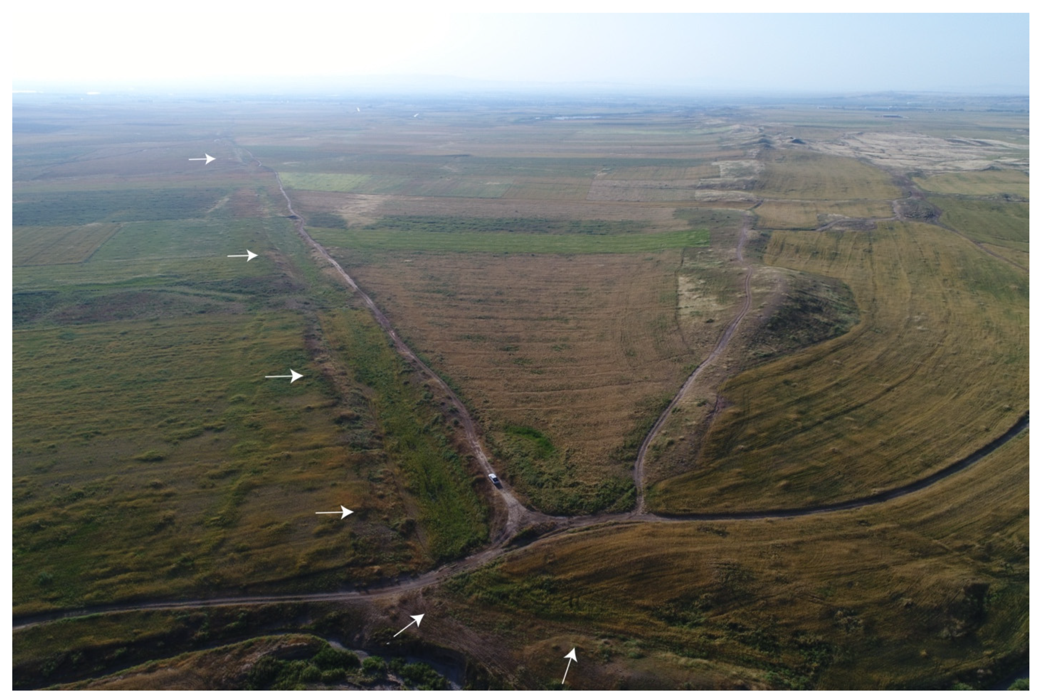
Finally, we noted an early 20th century railway system passing by Hawsh Kuru (SRP156) (Figure 11 and Figure 13). The location of the railway further emphasizes the corridor’s long history as a “landscape of movement” (after [89]) as well as the challenge of identifying even historic features in this landscape. Within the study area, the railway was only distinguished from other linear features (especially roads) in the satellite images by its association with two distinctive semicircular rail curves (Figure 13A,B), which were likely used in its construction. This portion of railroad, as pictured in Figure 11, was constructed by the British Army to extend the Basra to Baghdad railway line across the Iran–Iraq border [90,91]. It was completed in January 1920 and discontinued by 1922 [90]. In the 1951 imagery, the railway already appears defunct, missing several bridges and wadi crossings and is not recorded on the 1942 or 1956 British maps of the region. Instead, the railway runs parallel to and is sometimes crosscut by the road and telephone–telegraph lines indicated in these later maps, clarifying its early 20th century use-date.
3.1.5. Hydrological Modelling
Finally, one of the most important results from this study shows how advances in water management technology may have revolutionized the agricultural potential in the region, demonstrating the intimate knowledge past local people had with the region’s complex hydrology.
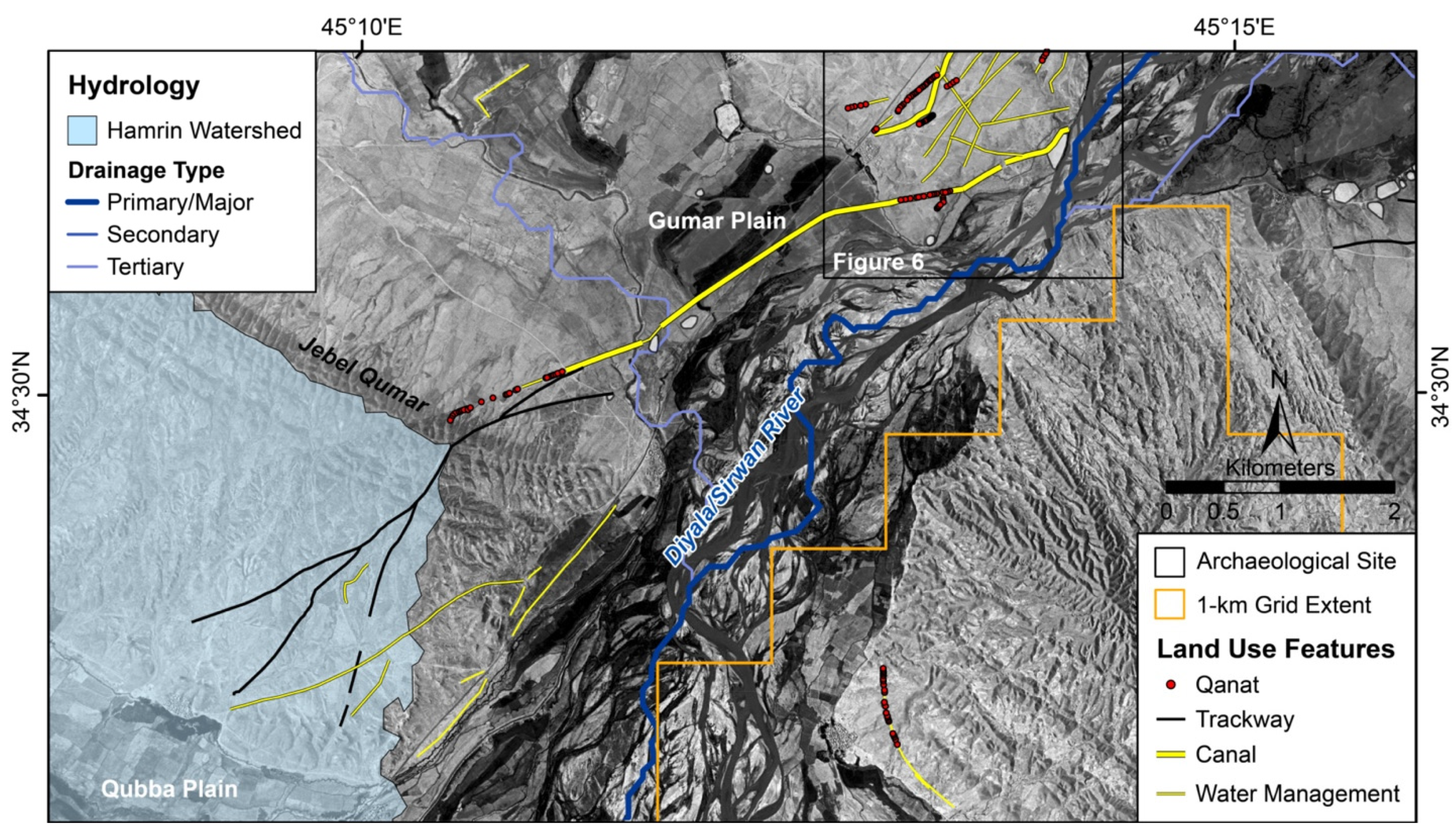
According to the SRTM hydrology model, topography in most of the Upper Diyala/Sirwan directs drainages directly toward the main branch of the Diyala/Sirwan River, except for the western part of the basin (highlighted in light blue in Figure 3 and Figure 14). Here, drainages south of the Jebel Qumar and in the Qubba plain instead flow away from the river, around the Jebel Nazaz, and into the Hamrin plain before emptying back into the river’s main channel. Figure 14 illustrates a number of previously unreported pre-modern irrigation canals that appear to be tapping the Diyala/Sirwan north of the Jebel Nazaz and directing water into the Qubba Plain. In this case, investing in channels to direct water from the Diyala/Sirwan River into the Qubba Plain would have a large return on investment by providing water for intensive cultivation over hundreds of square kilometers (114 km2 in the Qubba plain and potentially more than 300 km2 in the western Hamrin plain). Today, this feat is achieved with the help of diesel and electronically powered pumps.
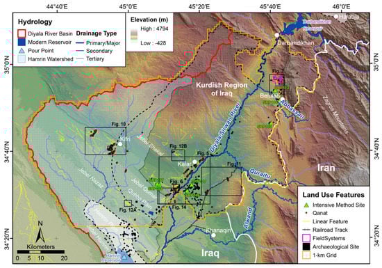
Figure 4.
Results of the systematic 1 km2 survey (gray grid) of the Upper Diyala/Sirwan region with land use features and figure insets indicated. Digital elevation model (DEM) basemap and hydrological features derived from 1 arc-second Shuttle Radar Topography Mission (SRTM) (courtesy NASA and USGS).


Figure 5.
Map of comparative land use feature density, settlement, and aridity on either side of the Upper Diyala/Sirwan River. In the August 1969 CORONA imagery, arid areas are lighter and moister areas with vegetation are darker.
Figure 5.
Map of comparative land use feature density, settlement, and aridity on either side of the Upper Diyala/Sirwan River. In the August 1969 CORONA imagery, arid areas are lighter and moister areas with vegetation are darker.
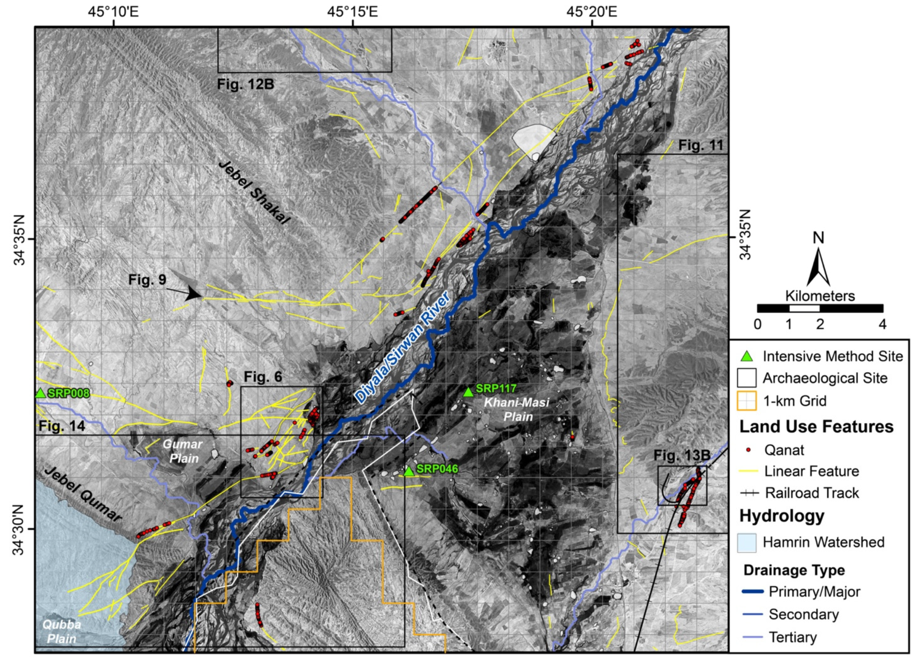
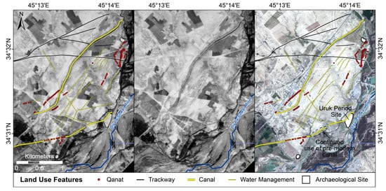
Figure 6.
“Taphonomic window” of land use feature preservation on the western side of Diyala/Sirwan River. The density of land use features also illustrates how all movement and large-scale land use networks are directed through a contained area. The left and central panes are Royal Airforce (RAF) aerial photos (November 1951), and the right pane is a WV-2 satellite image (February 2011; copyright 2011 DigitalGlobe, Inc.).
Figure 7.
CORONA (right) and 1951 RAF aerial photographs (left, insets A and B) of the constructed field systems. See Figure 4 for the location of Figure 7.

Figure 8.
Drone image of constructed field systems (facing northeast). Image by Jeff Kerby. See Figure 7 for the location of Figure 8.
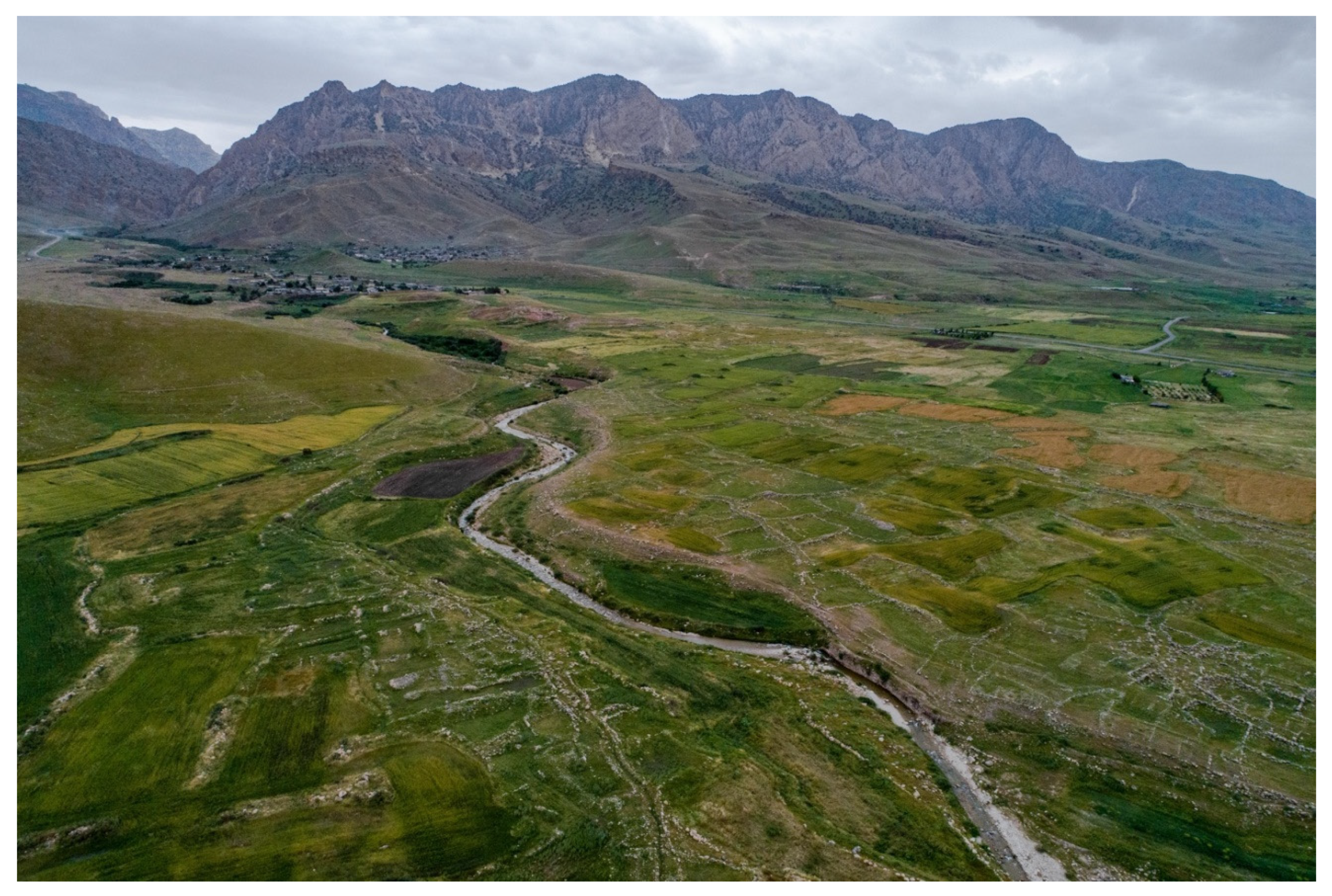

Figure 9.
Drone image of the Kalar-Gumar canal (facing east). See Figure 5 for image location. Image by Jeff Kerby.
Figure 9.
Drone image of the Kalar-Gumar canal (facing east). See Figure 5 for image location. Image by Jeff Kerby.
3.2. Targeted Intensive Survey
The project conducted targeted surveys at seven sites, collecting magnetic data across 8.36 ha and multispectral imagery over ca. 80 ha (Table 2). Land use features were detected at one site only—Tepe Shaho (SRP106), a small, high-mounded 1.1 ha multi-period tell site located in the Abbassan plain in the northern part of the study area (Figure 4 and Figure 15). At Tepe Shaho both magnetometry and the multispectral data extended 250 m and 300 m away, respectively, from the mounded edge of the site. In Figure 15, dark blue lines indicate features that are visible on the surface in 2018 WV-2 imagery. Yellow lines show features visible in both the UAV and magnetometry datasets but not in the modern imagery. Red lines are only visible in the magnetic data.
Additional investigations would be needed to date these features precisely, but a relative date can be determined based on their appearance in historic imagery, their cross-cutting relationships, and their association with Tepe Shaho. Comparing linear features to historic imagery (Figure 16), we found that all the features predate the 1950s but were variously visible on the different types of remote sensing. The dark blue features appear in all datasets and are still in use today as field boundaries. The longevity of these features (>70 years) despite highly disruptive modern agricultural activities suggests the Upper Diyala/Sirwan’s “landscapes of attrition” [2,87] may in fact have a high degree of land use continuity with previous periods. This means that field boundaries and canals that still appear in use in historical imagery could be hundreds of years old, complicating our assessment of land use intensity in the region. This uncertainty could be clarified with direct excavation and dating of land use features.
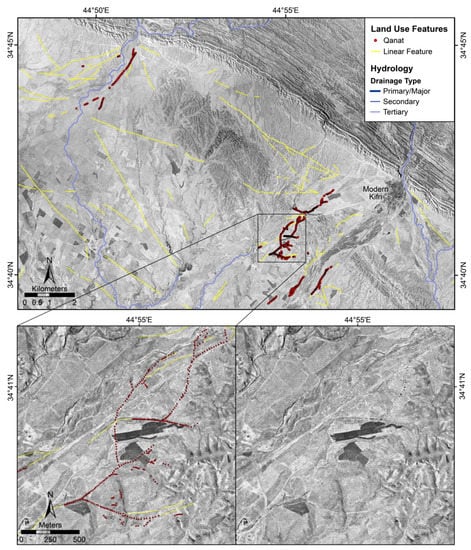
Figure 10.
Map of pre-modern linear features and qanat systems near modern Kifri visible on historic CORONA satellite imagery (Kurdish Region, Iraq). Figure inset shows qanat systems with multiple visible qanat shafts that appear as linear rows of dark spots. Basemap is CORONA imagery from August 1969 (courtesy USGS and CORONA Atlas).
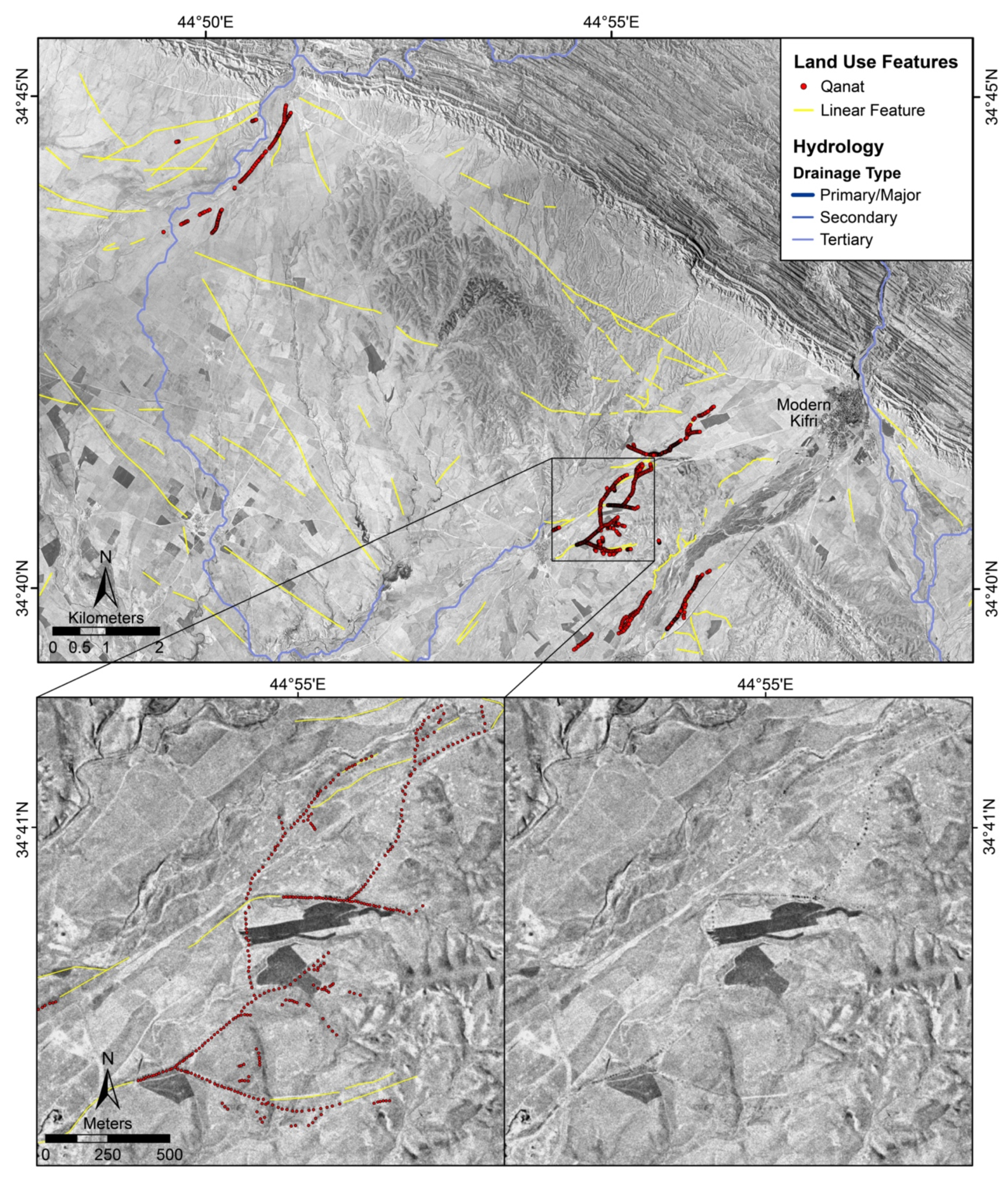
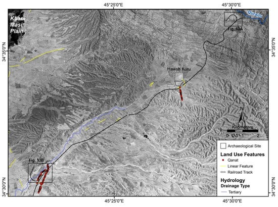
Figure 11.
Map of the qanat systems near the Sasanian center, Hawsh Kuru (SRP156). Basemap is CORONA imagery from August 1969 (courtesy USGS and CORONA Atlas).
Figure 11.
Map of the qanat systems near the Sasanian center, Hawsh Kuru (SRP156). Basemap is CORONA imagery from August 1969 (courtesy USGS and CORONA Atlas).
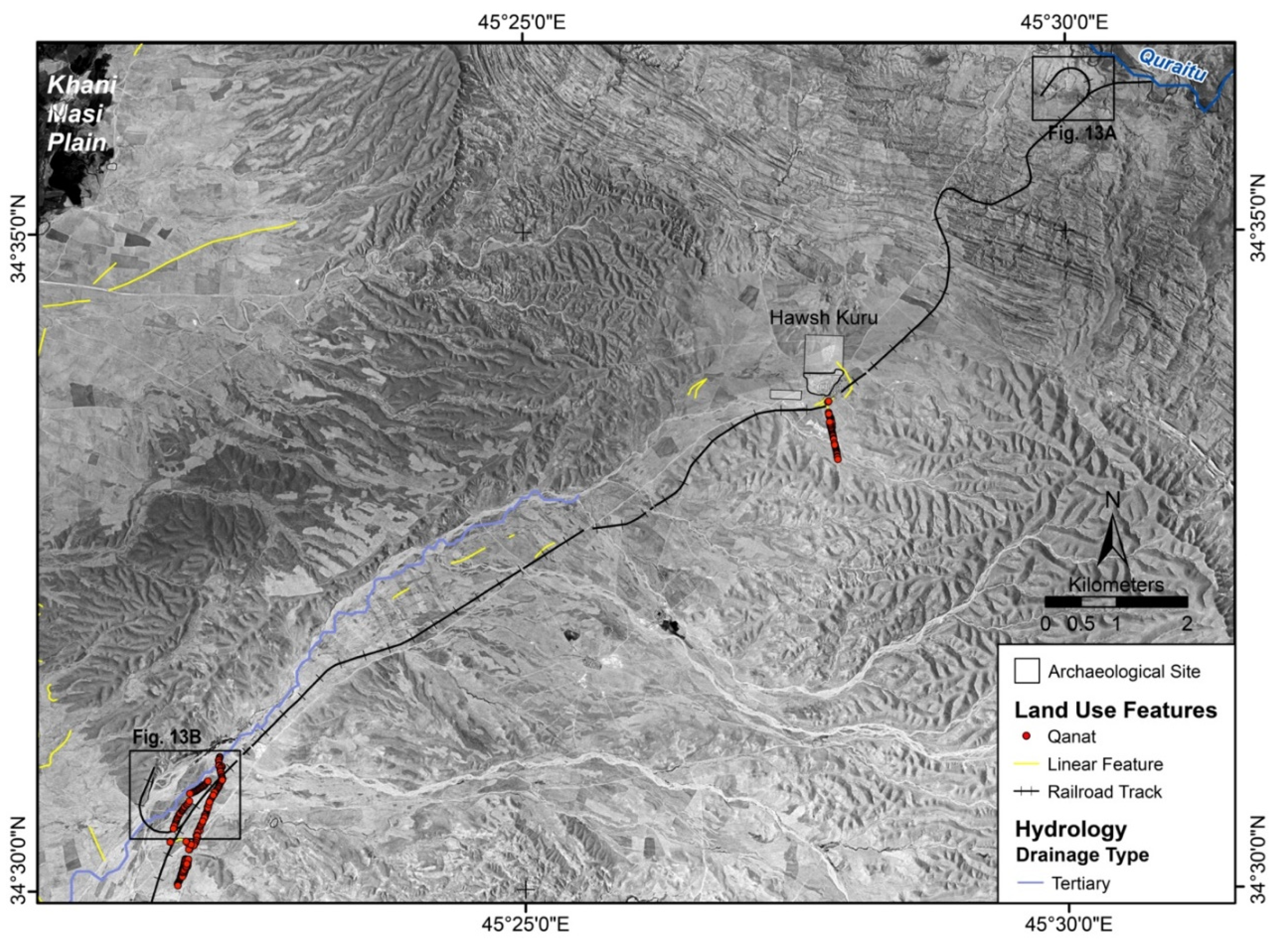
Figure 12.
Map of pre-modern trackways visible in (A) August 1969 CORONA imagery (courtesy USGS and CORONA Atlas) and (B) November 1951 RAF aerial photographs.
Figure 12.
Map of pre-modern trackways visible in (A) August 1969 CORONA imagery (courtesy USGS and CORONA Atlas) and (B) November 1951 RAF aerial photographs.
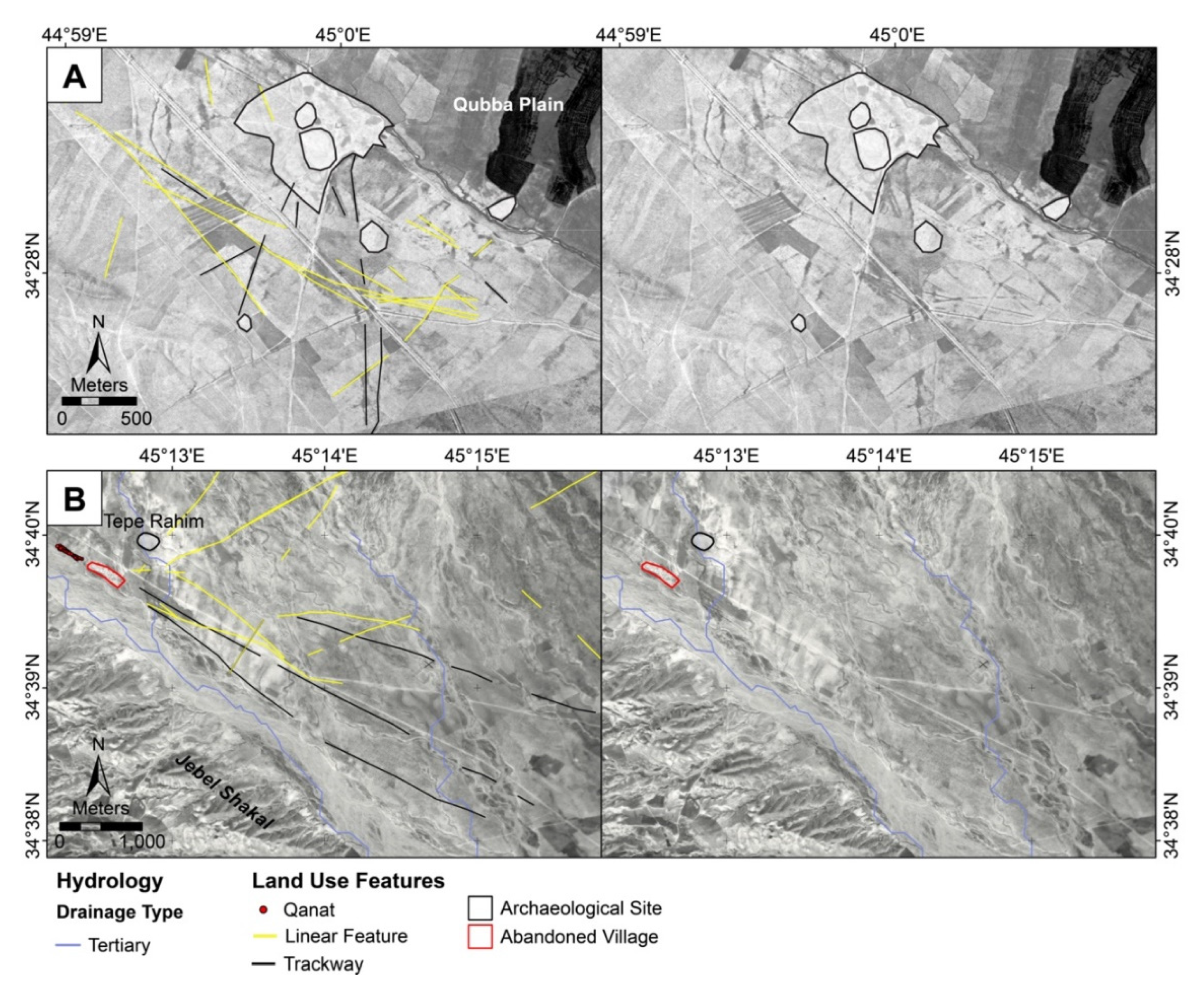
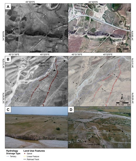
Figure 13.
Map of early 20th century railway. (A,B) Railway curves visible in 1951 (left) and modern Google Earth imagery (A, right: 2015; B, right: 2012). (C) UAV photo (facing southwest) of railway eroded by wadi and extending in the distance into the curve as picture in (B) (courtesy Jeff Kerby). (D) UAV photo (facing north-northwest) of railway cutting earlier qanat shaft and being eroded by wadi (courtesy Jeff Kerby).
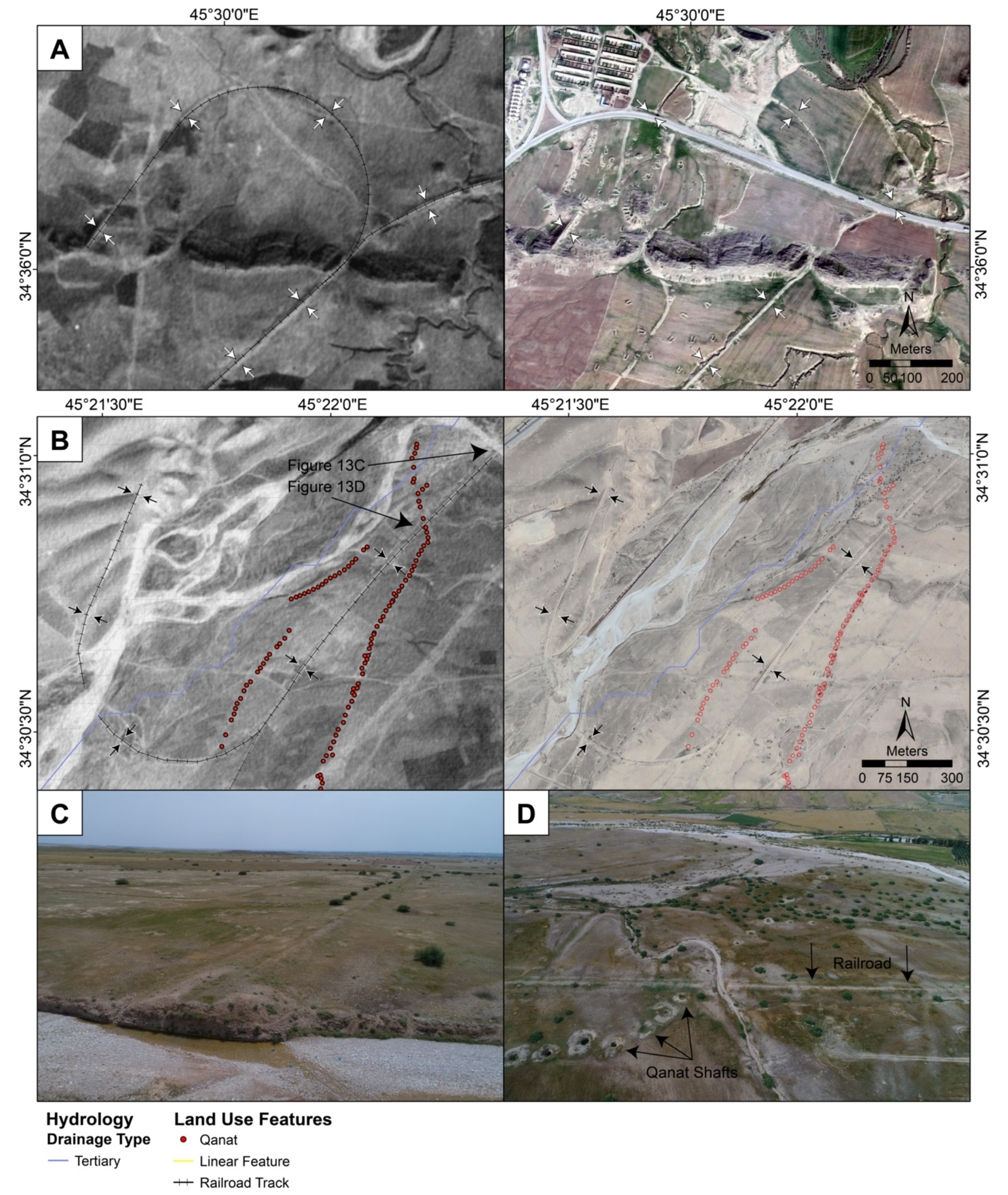
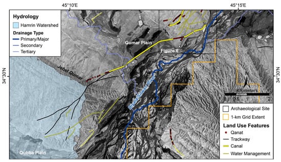
Figure 14.
Map of canal systems channeling water over and around the Jebel Qumar and into the Hamrin Watershed (light blue) and Qubba Plain. Basemap is CORONA imagery from August 1969 (courtesy USGS and CORONA Atlas).
Figure 14.
Map of canal systems channeling water over and around the Jebel Qumar and into the Hamrin Watershed (light blue) and Qubba Plain. Basemap is CORONA imagery from August 1969 (courtesy USGS and CORONA Atlas).
The dotted yellow linear features in Figure 16 appear in the 1951 and CORONA imagery but are no longer visible in modern satellite imagery, suggesting they are likely pre-modern, historic water channels or field boundaries. The solid yellow linear features, on the other hand, are not visible in any satellite or aerial images but appear in both drone-acquired multispectral imagery and geophysics, suggesting they are even older in date. The visibility of these features in color orthoimagery and NDVI data (Figure 15C,D) is a result of their impact on modern vegetation health. Their presence is preventing the more robust greening visible in surrounding fields, suggesting therefore that they are channels infilled with material inhibiting water retention. In this case, drone imagery was collected in February, an optimal time in the agricultural cycle to differentiate vegetation health, but we suspect that such features would remain visible in drone-acquired NDVI data at other times in the phenological cycle.
Finally, the red linear features are only visible in the magnetic data and are at a different orientation than all other features, being crosscut by them in several places, suggesting they are the earliest in the land use sequence. The proximity of the red linear features to Tepe Shaho suggests they are likely associated with the site that has been surveyed and excavated by the Sirwan Regional Project. Surface collections show a long history of occupation dating back to the Bronze Age or earlier, but a test excavation demonstrates that the site had a substantial Early and Middle Islamic occupation, likely continuing from the earlier Sasanian period. Given the occupational history of the site and the abundance of other similar field systems in the area, we suggest these field systems are contemporary with the latest occupations of the site (Sasanian to medieval).

Figure 15.
Results of the intensive surveys at Tepe Shaho (SRP106). (A) Interpretation and (B) processed data from the magnetic gradiometry survey (September 2018) overlaid on a 2018 Worldview 2 satellite image (copyright 2018 DigitalGlobe, Inc). (C) True color orthoimage and (D) NDVI raster generated from the drone-deployed multispectral camera (February 2019). White dashed lines indicate the extent of the magnetometry survey in each panel. See Figure 4 for the location of SRP106.
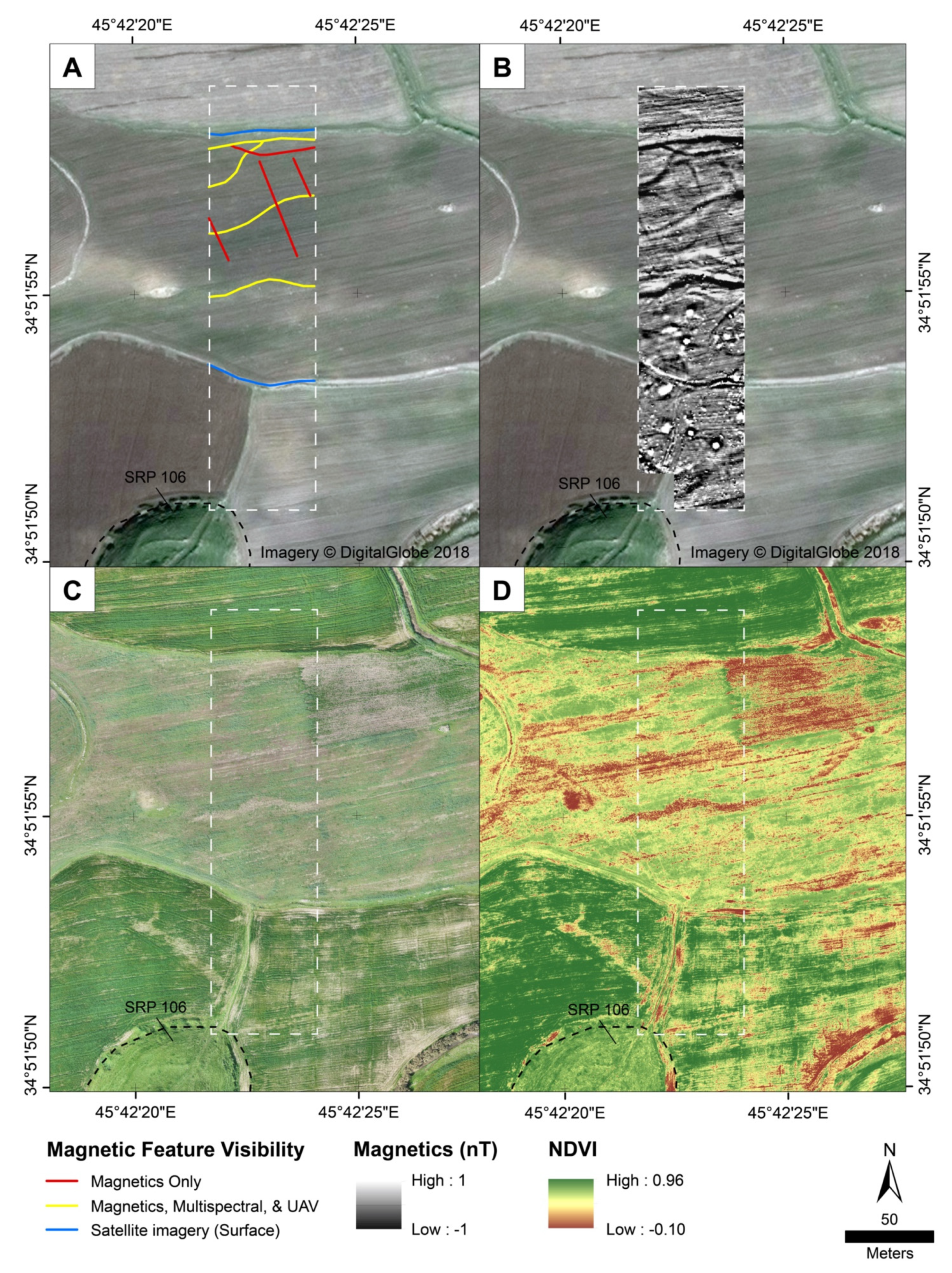
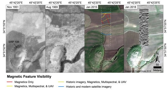
Figure 16.
Comparison of land use features in magnetometry data and historic and modern imagery at Tepe Shaho (SRP106). White dashed lines indicate the extent of the magnetometry survey in each panel. Basemap sources from left to right: November 1951 RAF photograph, August 1969 CORONA imagery (courtesy USGS and CORONA Atlas), and January 2015 and 2018 Worldview 2 satellite images (copyright 2018 DigitalGlobe, Inc). See Figure 4 for the location of SRP106.

4. Discussion
4.1. Long-Term Patterns in Regional Land Use
This systematic remote sensing study demonstrates the incredible diversity of land use features across the Sirwan/Diyala’s steep environmental gradient and reveals past residents’ intimate knowledge of how to leverage the region’s many microenvironments. The diversity and scale of land use features—the majority of which likely date to the Parthian-Sasanian period—also show a level of intensification and cooperation not visible in earlier periods of occupation. These results are consistent with the preliminary studies in the Upper Diyala/Sirwan and adjacent regions that all suggest that the late first millennium BCE through the first millennium CE were the periods of the highest population density and most intensive land use in the region’s history before the modern period [6,21,29,37,92].
The long-term trends in the Upper Diyala/Sirwan also closely align with landscape and remote sensing research in the adjacent Iranian Zagros foothills where Wilkinson and colleagues [92] also report an absence of fourth through second millennium BCE (Bronze Age) land use features. They [92,93] argue that the absence of evidence for Bronze Age land use features is related to a niche construction approach, in which farmers are highly attuned to the environment, manage small canal systems cooperatively, and make small changes over time (“bottom-up” initiatives). Conversely, more intensive, “top-down” land use initiatives employ major construction works to rapidly overcome environmental constraints. Such projects are usually associated with imperial powers and tend to leave the most visible evidence of land use on the landscape but also tend to be short-lived, often being abandoned due to maintenance difficulties.
Niche construction, as argued by Wilkinson and colleagues [92,93], is an important theoretical lens through which to understand hydraulic landscapes and the history of irrigation in Mesopotamia and can be used to explain the development of irrigation networks in the Upper Diyala/Sirwan under the Sasanian Empire. Niche construction may also explain the longevity of land use features in the Upper Diyala/Sirwan, many of which are still in use or along the same courses today. However, it does not fully explain the absence of land use features in the Bronze Ages and taphonomic arguments are also unsatisfactory.
Instead, the lack of evidence for Bronze Age land use may also be related to a regional reliance on pastoralism. The role of pastoralism is not adequately addressed in hydraulic histories, likely due to the challenges associated with detecting pastoral practices, particularly with remote sensing technologies. However, from the data and scale of analysis in this study, we cannot definitively say whether the absence of land use features is due to inclusive systems of land tenure, reliance on pastoralism, or a lack of preservation. Yet, without critical empirical data related to pastoral practice, we are left with an incomplete picture of Bronze Age land use. New phytolith research in the Upper Diyala/Sirwan is beginning to shed light on agro–pastoral practice in the region and shows that pastoral practice was site-based, but also extensive, where animals were free grazed on local hillsides throughout the year [43]. Integrating these disparate forms and scales of evidence will likely be critical for understanding long-term land use in Mesopotamia and beyond.
4.2. The Potential of Intensive Remote Sensing Technologies in Mesopotamian Landscapes
The success of intensive remote sensing methods at Tepe Shaho (SRP106) indicates that there is potential to deploy both technology types in Mesopotamia’s piedmont zones and that drone multispectral imagery has the greatest potential around long-lived, later period sites in rainfed areas; although other approaches will likely be required to investigate land use prior to the first millennium BCE. However, Tepe Shaho was the only site in this study where previously unknown land use features were detected using intensive remote sensing technologies. The fact that only one of the seven sites we investigated in this study had extant, resolvable pre-modern land use features shows that such features exist but are often difficult to recognize (Table 2). Future geophysical surveys could leverage a multi-sensor array to collect larger areas using a variety of different instruments, and multispectral drone surveys would greatly benefit from capturing much larger areas at lower spatial resolutions. For example, the new MicaSense RedEdge MX sensor collects multispectral data at 8 cm/pixel (GSD) at 120 m above ground level, allowing for much larger surveys at resolutions that are still effective for detecting anthropogenic features.
From the six sites where no land use features were detected, we may draw at least two further inferences. First, magnetic data indicates that sites in irrigated zones (SRP046 and 117) are surrounded by continuous archaeological landscapes and do not have distinct “off-site” areas. That is, human activities are present well beyond the mounded portions of sites indicating that occupation zones may be significantly more extensive than topographic relief and even ceramic density indicate. The continuous nature of occupation is particularly well-illustrated at Khani Masi (SRP046), where no clear edge of occupation was detected within 250 m of the site mound. The “off-site” magnetometry survey from Khani Masi (SRP046) was published in Glatz et al. [40]. This finding challenges the accepted notion, or definition, of what a site is in Mesopotamian archaeology.
Second, and conversely, sites in rainfed agricultural zones (SRP 8, 106, 113, 180, and 187) are surrounded by magnetically quiet landscapes. The magnetically quiet data surrounding the prehistoric site, Tepe Qumar (SRP 187), is expected given that agriculture was only nascent during the Hassuna period (6th–5th millennium BCE). For the other sites in rainfed areas (SRP 8, 180, and 187, are currently located above modern agricultural areas in the Gumar plain, which today requires irrigation for agriculture, but would likely have been a rainfed agricultural zone during the moister early- to mid-Holocene [94,95,96]), the quiet magnetic data aligns well with traditional definitions of archaeological sites in the region as well as the site formation processes (nucleation), and land use practices (extensification) expected for long-lived sites in rainfed areas [2,4].
5. Conclusions
This study integrated remotely sensed data from high-resolution historic and modern satellites, as well as data generated from ground-based geophysics and drone-mounted sensors. We recorded a range of previously undocumented pre-modern land use features and demonstrated the potential of intensive technologies for exploring beyond settlement areas in Mesopotamia (ancient Iraq). Results from this study connect land use surveys from the Zagros (Shahrizor Plain) to the Tigris confluence and complete the remote sensing survey of ancient land use features along the Diyala/Sirwan River.
The results demonstrate the importance of integrating both a systematic regional approach and intensive technologies to investigate past land use. In the Upper Diyala/Sirwan region, both preservation bias and poor visibility on satellite-scale imagery contribute to the perceived lack of ancient land use. Land use feature density is much lower in the Upper than in the Lower Diyala Region, but taphonomic windows of good preservation show that land use is more intensive than is accepted for piedmont zones. Land use features are best preserved (or at least clearly pre-modern) on the western side of the Diyala/Sirwan River, away from long-term settlement, modern cultivation, and areas with natural perennial water availability. The perceived lack of ancient land use in the Upper Diyala/Sirwan region is likely due to continuous, low intensity cultivation in a circumscribed river valley (i.e., a “landscape of attrition”), but could also be explained by the prevalence of more inclusive forms of land tenure and extensive forms of pastoralism, both of which produce few durable archaeological features.
Finally, it is worth noting that land use features generally appear more readily on 1951 aerial photography than in 1969 CORONA satellite imagery. This difference is due not only to the higher resolution of the earlier images, but to the two decades of intervening land use that erased or obscured many features. While episodes of intensive looting or destruction of sites have received widespread attention in recent years, agricultural activities have historically been and remain the greatest threat to both sites and traces of past land use [97]. Our results help to highlight the critical role that historical remote sensing datasets play in efforts to document archaeological features, and these resources should be key tools in future cultural heritage mapping efforts.
Author Contributions
Conceptualization, E.J.L. and J.C.; formal analysis, E.J.L. and J.C.; validation, E.J.L. and J.C.; resources, J.C.; writing—original draft preparation, E.J.L.; writing—review and editing, E.J.L. and J.C.; visualization, E.J.L. and J.C.; supervision, J.C.; funding acquisition, E.J.L. and J.C. All authors have read and agreed to the published version of the manuscript.
Funding
Funding for the project was provided by grants from the National Science Foundation (USA) Archaeology and Archaeometry Programs (1724488 and 1822107), the National Endowment for the Humanities (USA) Digital Humanities Advancement Grant (HAA- 256086-17), the ASOR Mesopotamian Fellowship Program, and the Clare Garber Goodman Fund at Dartmouth College as part of E.J.L.’s dissertation. This material is also based upon work supported by the National Science Foundation SBE Postdoctoral Research Fellowship under Grant No. (2104997).
Data Availability Statement
Historical imagery utilized in this study are publicly available through the United States Geological Survey, the UK National Collection of Aerial Photography, as well as through the CORONA Atlas Project (corona.cast.uark.edu) (accessed on 5 December 2021). Archaeological site locational data are held by the General Directorate of Antiquities of the Kurdistan Region of Iraq. Geophysical and drone-based imagery are maintained by the Spatial Archaeometry Lab (SPARCL) at Dartmouth College.
Acknowledgments
We would like to thank the General Directorate of Antiquities of the Kurdistan Region of Iraq and the Directorate of Antiquities of the Garmian Region for their support of the Sirwan Regional Project, the results of which form the basis of the research reported herein. Special thanks are due to Salih Mohammed Sameen, Awat Baban, Sarwat Majeed, and Nawzad Latif for their support during fieldwork. Claudia Glatz co-directed archaeological fieldwork conducted as part of the Sirwan Regional Project, Jeff Kerby assisted with field data collection and field photography, and Austin Chad Hill shared his expertise and assisted with the GPS and UAV deployment at Dartmouth’s Spatial Archaeometry Lab (SPARCL).
Conflicts of Interest
The authors declare no conflict of interest. The funders had no role in the design of the study; in the collection, analyses, or interpretation of data; in the writing of the manuscript; or in the decision to publish the results.
References
- Miller, N.; Gleason, K. (Eds.) The Archaeology of Garden and Field; University of Pennsylvania Press: Philadelphia, PA, USA, 1994; ISBN 978-0-585-08218-9. [Google Scholar]
- Wilkinson, T.J. Archaeological Landscapes of the Near East; University of Arizona Press: Tucson, AZ, USA, 2003; ISBN 978-0-8165-2173-9. [Google Scholar]
- Casana, J. Rethinking the Landscape: Emerging Approaches to Archaeological Remote Sensing. Annu. Rev. Anthropol. 2021, 50, 167–186. [Google Scholar] [CrossRef]
- Widell, M.; Hritz, C.; Ur, J.A.; Wilkinson, T.J. Land Use of the Model Communities. In Models of Mesopotamian Landscapes: How Small-Scale Processes Contributed to the Growth of Early Civilizations; BAR; Wilkinson, T.J., Gibson, M., Widell, M., Eds.; Archaeopress: Oxford, UK, 2013; pp. 56–80. [Google Scholar]
- Adams, R.M. Heartland of Cities: Surveys of Ancient Settlement and Land Use on the Central Floodplain of the Euphrates; University of Chicago Press: Chicago, IL, USA, 1981; ISBN 0-226-00544-5. [Google Scholar]
- Adams, R.M. Land Behind Baghdad: A History of Settlement on the Diyala Plains; University of Chicago Press: Chicago, IL, USA, 1965. [Google Scholar]
- Gasche, H.; Tanret, M. (Eds.) Changing Watercourses in Babylonia: Towards a Reconstruction of the Ancient Environment in Lower Mesopotamia; Mesopotamian History and Environment Series; The Oriental Institute, The University of Ghent: Chicago, IL, USA; Ghent, Belgium, 1998; Volume 1. [Google Scholar]
- Hritz, C. Tracing Settlement Patterns and Channel Systems in Southern Mesopotamia Using Remote Sensing. J. Field Archaeol. 2010, 35, 184–203. [Google Scholar] [CrossRef]
- Hritz, C.; Wilkinson, T.J. Using Shuttle Radar Topography to Map Ancient Water Channels in Mesopotamia. Antiquity 2006, 80, 415–424. [Google Scholar] [CrossRef] [Green Version]
- Jotheri, J.; Altaweel, M.; Tuji, A.; Anma, R.; Pennington, B.; Rost, S.; Watanabe, C. Holocene Fluvial and Anthropogenic Processes in the Region of Uruk in Southern Mesopotamia. Quat. Int. 2018, 483, 57–69. [Google Scholar] [CrossRef]
- Wilkinson, T.J.; Hritz, C. Physical Geography, Environmental Change, and the Role of Water. In Models of Mesopotamian landscapes: How Small-Scale Processes Contributed to the Growth of Early Civilizations; BAR; Wilkinson, T.J., Gibson, M., Widell, M., Eds.; Archaeopress: Oxford, UK, 2013; pp. 1–34. [Google Scholar]
- Schneider, U.; Becker, A.; Finger, P.; Meyer-Christoffer, A.; Rudolf, B.; Ziese, M. GPCC Full Data Reanalysis Version 7.0: Monthly Land-Surface Precipitation from Rain Gauges Built on GTS Based and Historic Data. Research Data Archive at the National Center for Atmospheric Research, Computational and Information Systems Laboratory. 2016. Available online: https://rda.ucar.edu/datasets/ds496.0/ (accessed on 1 December 2019).
- Ur, J.A. Emergent Landscapes of Movement in Early Bronze Age Northern Mesopotamia. In Landscapes of Movement: Trails, Paths, and Roads in Anthropological Perspective; Snead, J.E., Erickson, C.L., Darling, J.A., Eds.; University of Pennsylvania Museum of Archaeology and Anthropology: Philadelphia, PA, USA, 2009; pp. 180–203. ISBN 978-1-934536-13-1. [Google Scholar]
- Ur, J.A. CORONA Satellite Photography and Ancient Road Networks: A Northern Mesopotamian Case Study. Antiquity 2003, 77, 102–115. [Google Scholar] [CrossRef] [Green Version]
- Jotheri, J. The Google Earth File of Archaeological Sites of Southern Mesopotamia. Ph.D. Thesis, Durham University, Durham, UK, 2016. [Google Scholar] [CrossRef]
- Wilkinson, T.J. Settlement and Land Use in the Zone of Uncertainty in Upper Mesopotamia. In Rainfall and Agriculture in Northern Mesopotamia; Jas, R.M., Ed.; Nederlands Historisch-Archaeologisch Instituut te Istanbul: Leiden, The Nederlands, 2000; pp. 3–35. [Google Scholar]
- Pournelle, J.R.; Algaze, G. Travels in Edin: Deltaic Resilence and Early Urbanism in Greater Mesopotamia. In Preludes to Urbanism: The Late Chalcolithic of Mesopotamia; McMahon, A., Crawford, H., Eds.; McDonald Institute for Archaeological Research: Cambridge, UK, 2015; pp. 7–34. ISBN 978-1-902937-65-6. [Google Scholar]
- Casana, J. Radial Route Systems and Agro-Pastoral Strategies in the Fertile Crescent: New Discoveries from Western Syria and Southwestern Iran. J. Anthropol. Archaeol. 2013, 32, 257–273. [Google Scholar] [CrossRef]
- Wilkinson, T.J. Linear Hollows in the Jazira, Upper Mesopotamia. Antiquity 1993, 67, 548–562. [Google Scholar] [CrossRef]
- Wilkinson, T.J.; French, C.; Ur, J.A.; Semple, M. The Geoarchaeology of Route Systems in Northern Syria. Geoarchaeology 2010, 25, 745–771. [Google Scholar] [CrossRef]
- Rayne, L.; Donoghue, D. A Remote Sensing Approach for Mapping the Development of Ancient Water Management in the Near East. Remote Sens. 2018, 10, 2042. [Google Scholar] [CrossRef] [Green Version]
- Soroush, M.; Mehrtash, A.; Khazraee, E.; Ur, J.A. Deep Learning in Archaeological Remote Sensing: Automated Qanat Detection in the Kurdistan Region of Iraq. Remote Sens. 2020, 12, 500. [Google Scholar] [CrossRef] [Green Version]
- Ur, J. Sennacherib’s Northern Assyrian Canals: New Insights from Satellite Imagery and Aerial Photography. Iraq 2005, 67, 317–345. [Google Scholar] [CrossRef]
- English, P. Qanats and Lifeworlds in Iranian Plateau Villages. In Transformation of Middle Eastern Natural Environment, Bulletin Series; Albert, J., Bernhardsson, M., Kenna, R., Eds.; ALE School of Forestry & Environmental Studies Bulletin Series 98; Yale University: New Haven, CT, USA, 1998; Volume 103, pp. 187–205. [Google Scholar]
- Parker, B.J. Toward an Understanding of Borderland Processes. Am. Antiq. 2006, 71, 77–100. [Google Scholar] [CrossRef]
- Scott, J.C. The Art of Not Being Governed: An Anarchist History of Upland Southeast Asia; Yale University Press: London, UK, 2009; ISBN 978-0-300-15652-2. [Google Scholar]
- Braidwood, L.S.; Braidwood, R.J.; Howe, B.; Reed, C.A.; Watson, P.J. (Eds.) Prehistoric Archeology along the Zagros Flanks; Oriental Institute Publications; Oriental Institute of the University of Chicago: Chicago, IL, USA, 1983; ISBN 978-0-918986-36-8. [Google Scholar]
- Braidwood, R.J.; Howe, B. (Eds.) Prehistoric Investigations in Iraqi Kurdistan; Studies in Ancient Oriental Civilization; University of Chicago Press: Chicago, IL, USA, 1960; ISBN 0-226-62404-8. [Google Scholar]
- Casana, J.; Glatz, C. The Land Behind the Land Behind Baghdad: Archaeological Landscapes of the Upper Diyala (Sirwan) River Valley. Iraq 2017, 79, 1–23. [Google Scholar] [CrossRef] [Green Version]
- Frankfort, H.; Jacobsen, T.; Preusser, C. Tell Asmar and Khafaje: The First Season’s Work in Eshnunna 1930/31; Oriental Institute Communications; University of Chicago Press: Chicago, IL, USA, 1932. [Google Scholar]
- Frankfort, H.; Lloyd, S.; Jacobsen, T. The Gimilsin Temple and the Palace of the Rulers at Tell Asmar; Oriental Institute Publications; The University of Chicago Press: Chicago, IL, USA, 1940. [Google Scholar]
- Delougaz, P. The Temple Oval at Khafajah; Oriental Institute Publications; The University of Chicago Press: Chicago, IL, USA, 1940. [Google Scholar]
- Delougaz, P.; Hill, H.D.; Lloyd, S. Private Houses and Graves in the Diyala Region; Oriental Institute Publications; The University of Chicago Press: Chicago, IL, USA, 1967. [Google Scholar]
- Delougaz, P.; Lloyd, S. Pre-Sargonid Temples in the Diyala Region; Oriental Institute Publications; The University of Chicago Press: Chicago, IL, USA, 1942. [Google Scholar]
- Killick, R.G. (Ed.) Tell Rubeidheh: An Uruk Village in the Jebel Hamrin; Hamrin Salvage Project report, 7; Iraq Archaeological Reports, 2.; Aris & Phillips: Warminster, UK, 1988. [Google Scholar]
- Altaweel, M.; Marsh, A.; Mühl, S.; Nieuwenhuyse, O.; Radner, K.; Rasheed, K.; Saber, S.A. New Investigations in the Environment, History and Archaeology of the Iraqi Hilly Flanks: Shahrizor Survey Project 2009–2011. Iraq 2012, 74, 1–35. [Google Scholar] [CrossRef] [Green Version]
- Mühl, S.; Rösch, M.; Al-Manmi, D.A.M.; Kadereit, A.; Aziz, B.Q. Irrigation in the Shahrizor Plain: The Potential of Archaeological and Geoarchaeological Archives to Reconstruct Ancient Water Management. In Water for Assyria; Kühne, H., Ed.; Studia Chaburensia; Harrassowitz Verlag: Wiesbaden, Germany, 2018; Volume 7, pp. 117–136. ISBN 978-3-447-19740-3. [Google Scholar]
- Glatz, C.; Casana, J. Of Highland-Lowland Borderlands: Local Societies and Foreign Power in the Zagros-Mesopotamian Interface. J. Anthropol. Archaeol. 2016, 44, 127–147. [Google Scholar] [CrossRef] [Green Version]
- Panahipour, M. Land Use and Environment in a Zone of Uncertainty: A Case of the Sasanian Expansion in Eastern Iraq–Western Iran. Iran 2021, 59, 90–108. [Google Scholar] [CrossRef]
- Glatz, C.; Casana, J.; Bendrey, R.; Beysal, E.; Calderbank, D.; Chelazzi, F.; Del Bravo, F.; Erskine, N.; Hald, M.M.; Laugier, E.J.; et al. Babylonian Encounters in the Upper Diyala Valley: Contextualizing the Results of Regional Survey and the 2016–2017 Excavations at Khani Masi. Am. J. Archaeol. 2019, 123, 439–471. [Google Scholar] [CrossRef] [Green Version]
- Şerifoğlu, T.E.; Glatz, C.; Casana, J.; Haydar, S.M. The Sirwan (Upper Diyala) Regional Project–First Results. In The Archaeology of the Kurdistan Region of Iraq and Adjacent Regions; Konstantinos, K., MacGinnis, J., Eds.; Archaeopress: Oxford, UK, 2016; pp. 403–410. ISBN 978-1-78491-393-9. [Google Scholar]
- Perruchini, E.; Glatz, C.; Hald, M.M.; Casana, J.; Toney, J.L. Revealing Invisible Brews: A New Approach to the Chemical Identification of Ancient Beer. J. Archaeol. Sci. 2018, 100, 176–190. [Google Scholar] [CrossRef] [Green Version]
- Laugier, E.J.; Casana, J.; Glatz, C.; Sameen, S.M.; Cabanes, D. Reconstructing Agro-Pastoral Practice in the Mesopotamian-Zagros Borderlands: Insights from Phytolith and FTIR Analysis of a Dung-Rich Deposit. J. Archaeol. Sci. Rep. 2021, 38, 103106. [Google Scholar] [CrossRef]
- Jotheri, J. Holocene Avulsion History of the Euphrates and Tigris Rivers in the Mesopotamian Floodplain. Ph.D. Thesis, Durham University, Durham, UK, 2016. Available online: http://etheses.dur.ac.uk/11752/ (accessed on 5 December 2021).
- Schneider, U.; Becker, A.; Finger, P.; Rustemeier, E.; Ziese, M. GPCC Full Data Monthly Product Version 2020 at 0.25°: Monthly Land-Surface Precipitation from Rain-Gauges Built on GTS-Based and Historical Data. Global Precipitation Climatology Centre (GPCC) at Deutscher Wetterdienst. 2020. Available online: https://www.doi.org/10.5676/DWD_GPCC/FD_M_V2020_025 (accessed on 3 January 2021).
- Luo, L.; Wang, X.; Guo, H.; Lasaponara, R.; Zong, X.; Masini, N.; Wang, G.; Shi, P.; Khatteli, H.; Chen, F.; et al. Airborne and Spaceborne Remote Sensing for Archaeological and Cultural Heritage Applications: A Review of the Century (1907–2017). Remote Sens. Environ. 2019, 232, 111280. [Google Scholar] [CrossRef]
- Hritz, C. Contributions of GIS and Satellite-Based Remote Sensing to Landscape Archaeology in the Middle East. J. Archaeol. Res. 2014, 22, 229–276. [Google Scholar] [CrossRef]
- Kouchoukos, N. Satellite Images and Near Eastern Landscapes. East. Archaeol. 2001, 64, 80–91. [Google Scholar] [CrossRef]
- Lawrence, D.; Altaweel, M.; Philip, G. (Eds.) New Agendas in Remote Sensing and Landscape Archaeology in the Near East: Studies in Honour of Tony J. Wilkinson; Archaeopress Publishing Ltd.: Oxford, UK, 2020; ISBN 978-1-78969-574-8. [Google Scholar]
- Menze, B.H.; Ur, J.A. Mapping Patterns of Long-Term Settlement in Northern Mesopotamia at a Large Scale. Proc. Natl. Acad. Sci. USA 2012, 109, E778–E787. [Google Scholar] [CrossRef] [PubMed] [Green Version]
- van Liere, W.; Lauffray, J. Nouvelle Prospection Archéologique Dans La Haute Jezireh Syrienne. AAS 1954, IV–V, 129–148. [Google Scholar]
- Wilkinson, T.J. Regional Approaches to Mesopotamian Archaeology: The Contribution of Archaeological Surveys. J. Archaeol. Res. 2000, 8, 219–267. [Google Scholar] [CrossRef]
- Casana, J. Global-Scale Archaeological Prospection Using CORONA Satellite Imagery: Automated, Crowd-Sourced, and Expert-Led Approaches. J. Field Archaeol. 2020, 45, S89–S100. [Google Scholar] [CrossRef] [Green Version]
- Casana, J.; Cothren, J. The CORONA Atlas Project: Orthorectification of CORONA Satellite Imagery and Regional-Scale Archaeological Exploration in the Near East. In Mapping Archaeological Landscapes from Space; Comer, D., Harrower, M.J., Eds.; Springer: New York, NY, USA, 2013; pp. 31–41. ISBN 978-1-4614-6073-2. [Google Scholar]
- Casana, J.; Cothren, J. Stereo Analysis, DEM Extraction and Orthorectification of CORONA Satellite Imagery: Archaeological Applications from the Near East. Antiquity 2008, 82, 732–749. [Google Scholar] [CrossRef] [Green Version]
- Hammer, E.; Ur, J. Near Eastern Landscapes and Declassified U2 Aerial Imagery. Adv. Archaeol. Pract. 2019, 7, 107–126. [Google Scholar] [CrossRef] [Green Version]
- Philip, G.; Donoghue, D.; Beck, A.; Galiatsatos, N. CORONA Satellite Photography: An Archaeological Application from the Middle East. Antiquity 2002, 76, 109–118. [Google Scholar] [CrossRef] [Green Version]
- Casana, J.; Cothren, J.; Kalayci, T. Swords into Ploughshares: Archaeological Applications of CORONA Satellite Imagery in the Near East. Internet Archaeol. 2012, 32. [Google Scholar] [CrossRef]
- Khanaqin Sheet I-38 J. 1943. Iraq and Iran Series K501. Washington, D.C.: U.S. Army Map Service. Available online: http://legacy.lib.utexas.edu/maps/ams/iraq_and_iran/ (accessed on 14 August 2019).
- NI 38-7 Khanaqin. 1957. Southwestern Asia Series K502. Washington, D.C.: U.S. Army Map Service. Available online: http://legacy.lib.utexas.edu/maps/ams/southwestern_asia/ (accessed on 30 October 2018).
- Casana, J. Regional-Scale Archaeological Remote Sensing in the Age of Big Data. Adv. Archaeol. Pract. J. Soc. Am. Archaeol. 2014, 2, 222–233. [Google Scholar] [CrossRef]
- Gaffney, C.; Gaffney, V.; Neubauer, W.; Baldwin, E.; Chapman, H.; Garwood, P.; Moulden, H.; Sparrow, T.; Bates, R.; Löcker, K.; et al. The Stonehenge Hidden Landscapes Project. Archaeol. Prospect. 2012, 19, 147–155. [Google Scholar] [CrossRef]
- Johnson, J. (Ed.) Remote Sensing in Archaeology: An Explicitly North American Perspective; University of Alabama Press: Tuscaloosa, AL, USA, 2006; ISBN 978-0-8173-5343-8. [Google Scholar]
- McKinnon, D.P.; Haley, B.S. (Eds.) Archaeological Remote Sensing in North America: Innovative Techniques for Anthropological Applications; University of Alabama Press: Tuscaloosa, AL, USA, 2017; ISBN 978-0-8173-1959-5. [Google Scholar]
- Becker, H. Caesium-Magnetometry for Landscape-Archaeology. In Seeing the Unseen: Geophysics and Landscape Archaeology; Campana, S., Piro, S., Eds.; CRC Press: Leiden, The Netherlands, 2009; pp. 129–165. [Google Scholar]
- Casana, J.; Herrmann, J.T. Settlement History and Urban Planning at Zincirli Höyük, Southern Turkey. J. Mediterr. Archaeol. 2010, 23, 55–80. [Google Scholar] [CrossRef]
- Castel, C.; Gondet, S. Prospection Géophysique à Al-Rawda et Urbanisme En Syrie Au Bronze Ancien. Paléorient 2004, 30, 93–109. [Google Scholar] [CrossRef]
- Creekmore, A. The Structure of Upper Mesopotamian Cities: Insight from Fluxgate Gradiometer Survey at Kazane Höyük, Southeastern Turkey. Archaeol. Prospect. 2010, 17, 73–88. [Google Scholar] [CrossRef]
- Schwartz, G.M.; Brinker, C.D.; Creekmore, A.T.; Feldman, M.H.; Smith, A.; Weber, J.A. Excavations at Kurd Qaburstan, A Second Millennium BC Urban Site on the Erbil Plain. Iraq 2017, 79, 213–255. [Google Scholar] [CrossRef]
- Kvamme, K.L. Geophysical Surveys as Landscape Archaeology. Am. Antiq. 2003, 68, 435–457. [Google Scholar] [CrossRef]
- Fassbinder, J.W.E. Beneath the Euphrates Sediments: Magnetic Traces of the Mesopotamian Megacity Uruk-Warka. Anc. East ANE Today 2020, 8. Available online: https://www.asor.org/anetoday/2020/06/euphrates-sediments (accessed on 5 December 2021).
- Thornley, D. Fluxgate Gradiometry Survey at Bestansur. In The Early Neolithic of The Eastern Fertile Crescent: Excavations at Bestansur and Shimshara, Iraqi Kurdistan; Matthews, R., Matthews, W., Raheem, K.R., Richardson, A., Eds.; Central Zagros Archaeological Project Czap Reports Volume 2; Oxbow Books: Oxford, UK, 2020; pp. 57–63. [Google Scholar]
- Hill, A.C.; Limp, F.; Casana, J.; Laugier, E.J.; Williamson, M. A New Era in Spatial Data Recording: Low-Cost GNSS. Adv. Archaeol. Pract. 2019, 7, 169–177. [Google Scholar] [CrossRef] [Green Version]
- Kvamme, K.L. Remote Sensing Approaches to Archaeological Reasoning: Pattern Recognition and Physical Principles. In Archaeological Concepts for the Study of the Cultural Past; University of Utah Press: Salt Lake City, UT, USA, 2008; pp. 65–84. [Google Scholar]
- Campana, S. Drones in Archaeology. State-of-the-Art and Future Perspectives. Archaeol. Prospect. 2017, 24, 275–296. [Google Scholar] [CrossRef]
- Herrmann, J.T.; Glissmann, B.; Sconzo, P.; Pfälzner, P. Unmanned Aerial Vehicle (UAV) Survey with Commercial-Grade Instruments: A Case Study from the Eastern Ḫabur Archaeological Survey, Iraq. J. Field Archaeol. 2018, 43, 269–283. [Google Scholar] [CrossRef]
- Opitz, R.; Herrmann, J. Recent Trends and Long-Standing Problems in Archaeological Remote Sensing. J. Comput. Appl. Archaeol. 2018, 1, 19–41. [Google Scholar] [CrossRef] [Green Version]
- Nichols, D.L. Infrared Aerial Photography and Prehispanic Irrigation at Teotihuacán: The Tlajinga Canals. J. Field Archaeol. 1988, 15, 17–27. [Google Scholar] [CrossRef]
- Casana, J.; Wiewel, A.; Cool, A.; Hill, A.C.; Fisher, K.D.; Laugier, E.J. Archaeological Aerial Thermography in Theory and Practice. Adv. Archaeol. Pract. 2017, 5, 310–327. [Google Scholar] [CrossRef] [Green Version]
- Casana, J.; Kantner, J.; Wiewel, A.; Cothren, J. Archaeological Aerial Thermography: A Case Study at the Chaco-Era Blue J Community, New Mexico. J. Archaeol. Sci. 2014, 45, 207–219. [Google Scholar] [CrossRef]
- Fuldain González, J.J.; Varón Hernández, F.R. NDVI Identification and Survey of a Roman Road in the Northern Spanish Province of Álava. Remote Sens. 2019, 11, 725. [Google Scholar] [CrossRef] [Green Version]
- Hill, A.C.; Laugier, E.J.; Casana, J. Archaeological Remote Sensing Using Multi-Temporal, Drone-Acquired Thermal and Near Infrared (NIR) Imagery: A Case Study at the Enfield Shaker Village, New Hampshire. Remote Sens. 2020, 12, 690. [Google Scholar] [CrossRef] [Green Version]
- McLeester, M.; Casana, J.; Schurr, M.R.; Hill, A.C.; Wheeler, J.H. Detecting Prehistoric Landscape Features Using Thermal, Multispectral, and Historical Imagery Analysis at Midewin National Tallgrass Prairie, Illinois. J. Archaeol. Sci. Rep. 2018, 21, 450–459. [Google Scholar] [CrossRef]
- Moriarty, C.; Cowley, D.C.; Wade, T.; Nichol, C.J. Deploying Multispectral Remote Sensing for Multi-Temporal Analysis of Archaeological Crop Stress at Ravenshall, Fife, Scotland. Archaeol. Prospect. 2019, 26, 33–46. [Google Scholar] [CrossRef] [Green Version]
- Parrot Sequoia User Guide. Available online: https://support.micasense.com/hc/en-us/articles/219325487-Quick-Start-Guide-and-User-Guide-PDF (accessed on 28 February 2018).
- Casana, J.; Laugier, E.J.; Hill, A.C.; Blakeslee, D. A Council Circle at Etzanoa? Multi-Sensor Drone Survey at an Ancestral Wichita Settlement in Southeastern Kansas. Am. Antiq. 2020, 85, 761–780. [Google Scholar] [CrossRef]
- Mühl, S. Human Landscape-Site (Trans-) Formation in the Transigris Area. In Tells: Social and Environmental Space [Proceedings of the International Workshop “Socio-Environmental Dynamics over the Last 12,000 Years: The Creation of Landscapes II (14th-18th March 2011)” in Kiel]; Hofmann, R., Moetz, F.-K., Müller, J., Eds.; Habelt: Bonn, Germany, 2012; pp. 79–92. [Google Scholar]
- Algaze, G. The Uruk World System: The Dynamics of Expansion of Early Mesopotamian Civilization, 2nd ed.; University of Chicago Press: Chicago, IL, USA, 2005; ISBN 978-0-226-01382-4. [Google Scholar]
- Snead, J.E.; Erickson, C.L.; Darling, J.A. Making Human Space: The Archaeology of Trails, Paths, and Roads. In Landscapes of Movement: Trails, Paths, and Roads in Anthropological Perspective; Snead, J.E., Erickson, C.L., Darling, Eds.; Penn Museum International Research Conferences; University of Pennsylvania Museum of Archaeology and Anthropology: Philadelphia, PA, USA, 2009; pp. 1–19. ISBN 978-1-934536-13-1. [Google Scholar]
- Hughes, H. Middle East Railways; The Continental Railway Circle: Harrow, UK, 1981; ISBN 978-0-9503469-7-7. [Google Scholar]
- Wilson, A.T. Loyalties: Mesopotamia 1917–1920, 2nd ed.; Oxford University Press: Oxford, UK, 1936; Volume 2. [Google Scholar]
- Wilkinson, T.J.; Boucharlat, R.; Ertsen, M.W.; Gillmore, G.; Kennet, D.; Magee, P.; Rezakhani, K.; Schacht, T.D. From Human Niche Construction to Imperial Power: Long-Term Trends in Ancient Iranian Water Systems. Water Hist. 2012, 4, 155–176. [Google Scholar] [CrossRef]
- Wilkinson, T.J.; Rayne, L.; Jotheri, J. Hydraulic Landscapes in Mesopotamia: The Role of Human Niche Construction. Water Hist. 2015, 7, 397–418. [Google Scholar] [CrossRef]
- Djamali, M.; De Beaulieu, J.-L.; Miller, N.F.; Andrieu-Ponel, V.; Ponel, P.; Lak, R.; Sadeddin, N.; Akhani, H.; Fazeli, H. Vegetation History of the SE Section of the Zagros Mountains during the Last Five Millennia; a Pollen Record from the Maharlou Lake, Fars Province, Iran. Veg. Hist. Archaeobotany 2009, 18, 123–136. [Google Scholar] [CrossRef]
- Flohr, P.; Fleitmann, D.; Matthews, R.; Matthews, W.; Black, S. Evidence of Resilience to Past Climate Change in Southwest Asia: Early Farming Communities and the 9.2 and 8.2 Ka Events. Quat. Sci. Rev. 2016, 136, 23–39. [Google Scholar] [CrossRef]
- Roberts, N.; Eastwood, W.J.; Kuzucuolu, C.; Fiorentino, G.; Caracuta, V. Climatic, Vegetation and Cultural Change in the Eastern Mediterranean during the Mid-Holocene Environmental Transition. Holocene 2011, 21, 147–162. [Google Scholar] [CrossRef]
- Casana, J.; Laugier, E.J. Satellite Imagery-Based Monitoring of Archaeological Site Damage in the Syrian Civil War. PLoS ONE 2017, 12, e0188589. [Google Scholar] [CrossRef] [Green Version]
Publisher’s Note: MDPI stays neutral with regard to jurisdictional claims in published maps and institutional affiliations. |
© 2021 by the authors. Licensee MDPI, Basel, Switzerland. This article is an open access article distributed under the terms and conditions of the Creative Commons Attribution (CC BY) license (https://creativecommons.org/licenses/by/4.0/).